
Locating Remote Proximities: Documenting Yugoslav Socialist Memorial Heritage
ERIKA LINDSAY
University of Detroit Mercy
In the summer of 2016, I set out on a solo research trip to document Partisan memorials in the territory of former Yugoslavia. This iteration of the fieldwork would last for six weeks as compared to the initial ten-day-long trip taken in 2013 (and the recently completed four-week long journey made in July 2017). In the months leading up to the fieldwork, I researched each of the 28 memorials, locating, mapping and planning routes between sites, towns and cities across Serbia, Macedonia, Croatia, BosniaHerzegovina, and Slovenia. During this time, I drove 4,853 kilometers across the five countries.
Sited in former Yugoslavia, this project situates itself between a particular point of time in history when the state of Yugoslavia existed and these memorials came into being and their current plight in today’s post-Yugoslav context. These memorial sites are at odds with the nationalist and revisionist ideologies increasingly present in the region and subject to the myriad collective memories of people living in the countries of former Yugoslavia. The inspiration for this paper came from the many ways that notions of the proximate and remote slip back and forth geographically, conceptually, and politically in this project. Rather than focus solely on research outcomes, I aim to discuss the tools and techniques employed to render remote sites of study visible.
While conducting the research, I moved between clearly defined point locations and geographically diffuse field conditions in attempts to locate memorials. Monuments erected in both urban and rural contexts, the latter which commemorate partisan hospitals, battles, and strongholds, are typically found in remote locations. Sites exist along a
gradient of discoverability; ranging from simple to locate (marked with signage and visible) to the nearly impossible to find (down unmarked overgrown pathways), invisible until confronted. When housed in remote locations, memorial areas operate as urban enclaves, providing gathering space, circulation, lighting and other infrastructure for large-scale commemorative events. These memorial areas meld familiarity of urban infrastructure in distant locations, mediating them and rendering them less wild, unknowable and remote. Vestiges of this decaying civic infrastructure of mediation bear witness that a memorial site was present in instances when the memorial itself was less fortunate.
Lack of infrastructure produced conditions which rendered an already distant location that much more remote. Some areas were left far more devastated than others following the breakup of Yugoslavia in 1991— to this day some regions are still undergoing de-mining efforts. GPS-enabled devices attempt to plot routes across non-existent bridges, down logging roads, and through abandoned villages. In the absence of known infrastructure and reliable GPS, I turned to human interaction filled with handwritten maps and roadside conversations in broken languages and gestures. In each country, locals offered help to navigate to the site. While engaging this human infrastructure brimming with local knowledge, the remote became far less distant and unknowable to me, underscoring the relative nature of our relationship to the idea of remoteness.

BACKGROUND
This paper follows my efforts to locate and document a series of memorial sites erected to commemorate significant battles and strongholds of the Yugoslav Partisans during the Second World War. In 2012, I began independent research into the circumstances surrounding conservation efforts of these sites.1 As I continued to research these memorial sites, I uncovered numerous complex factors contributing to their varying states of conservation, including but not limited to; individual status as a protected monument, commemorative subject, and geographic location. With the hope of uncovering the complexities surrounding conservation of these sites, I pursued field work documenting a small number of monuments in Croatia, Bosnia-Herzegovina, and Serbia in summer of 2013. As I prepared to locate these sites geographically, at exact points in space, it became apparent that my pursuit to locate them conceptually; as aesthetic objects of importance, as situations to be understood through conservation, and as objects of circumstance, had in effect rendered the actuality of them far more distant. Sites which felt familiar from months of research and an understanding of the manylayered and nuanced circumstances felt incredibly remote, in a place
and from a time unfamiliar. Later attempts to reconcile this only further illuminated that I held a small amount of practical information useful to determine their exact location. It was at this moment that my proximate understanding clashed with the geographically remote nature of them as sites. Once I arrived, this became glaringly obvious, as I relied upon information gleaned from viral blog posts featuring these monuments to guide me. Unaware of how difficult some of these sites would be to find, I began my trip with only these named locations and a vague idea of how to move between them.
At that time it wasn’t evident to what extent Kempenaers’ Spomenik photographs had decontextualized these sites 2 . His technique of using only the name of the nearest city to label a monument stripped the sites of all commemorative and historical significance . Imaging the sites in winter against a backdrop of dreary grey sky served to decontextualize the monuments even further, cementing his interest in them as aesthetic objects and as part of a specific abandonment narrative. Though critical of Kempenaers’ decontextualization of these monuments, I would be remiss if I did not credit his images as my initial point of entry into the topic. His use of an overly simplified abandonment narrative resonated with me, as someone who hails from Detroit, a city subject to similarly reductive narratives of abandonment.
This research tracks the evolution of these sites and uncovers the circumstances surrounding conservation (or lack thereof) to understand their role as cultural signifiers in their contemporary and evolving post-socialist context. This paper discusses the tools and techniques employed to perform this research and utilizes a series of case study monuments to consider methodologies used to find sites that have been rendered invisible by time, neglect, or purposeful erasure.
HISTORIC CONTEXT
Yugoslavia entered the second world war a kingdom and emerged a socialist federal republic. Formed immediately following the war, the formation of this iteration of Yugoslavia was aided in part by Partisan liberation tactics and comprised of; Serbia (which included two autonomous provinces), Macedonia, Croatia, Bosnia-Herzegovina, Montenegro, and Slovenia. Liberated territories dotted the landscape and worked as a network to form the backbone of the Partisan anti-fascist resistance to the Axis powers in occupied Yugoslavia. In figure 1, a map of Yugoslavia shows the country as it existed from 1945 until 1991 — note the Dinaric Alps which stretch across the region from north to south, forming the majority of the mountainous landscape found there. Of note is the precarious location of this central European nation, east of Italy and Albania along the coast of the Adriatic, west of Romania and Bulgaria, south of Hungary and Austria, and North of Greece.
After WWII, the new Yugoslav government began work building the nation ideologically as well as physically. As part of this industrialization process, the government commenced large-scale public projects, villages became electrified, and roads were built throughout the countryside, connecting communities to cities. It is this infrastructure that made the construction of memorial areas in remote landscapes possible. Thousands of partisan monuments and memorials to the National Liberation Struggle were erected over a span of about 30 years, marking victories and remembering the fallen as part of the nation-building project of Yugoslavia. Memorials range in size from simple plaques to large-scale multi-story, occupiable buildings. The Monument to the Revolutionary Victory of The People of Slavonia sits atop Blažuj hill in the now abandoned village of Kamenska. 3
More than half of the monuments erected have been destroyed; by the war in the nineties, or if they survived the war, by nationalists or local governments. 4 The memorial in Kamenska, shown under construction in figure 2 was dynamited multiple times over five days by the Croatian National Army in 1992 until it collapsed. This monumental abstract sculpture standing at 30 meters (98 feet) and built over a decade was considered an engineering marvel and wind tunnel tested to guarantee its resistance to wind loads, and apparently some amount of dynamite blasting.
In its post-socialist context, the region has witnessed a fracturing of collective memory, borne of nationalist narratives of revisionism focused on differences. In some post-Yugoslav countries, this emphasis has produced a binary relationship to the past — a simultaneous
rejection of Yugoslav collective heritage and with it the resulting liberation of the histories of each separate nation. These histories are often constructed by geographically fracturing historically Yugoslav narratives, which leads to nations fighting for ownership of historically significant figures. Yugoslavia as a concept is caught temporally between — beginning with the traumatic events of WWII and ending with the war in the nineties, these events bookend the very existence of the country and the production of these memorials. As sites that mark the history of Yugoslavia’s role in WWII fade from memory, Homeland War narratives enmeshed in nationalist ideology shape the fractured collective memories of people living in the territory of former Yugoslavia. The current context of these monuments, unfortunately, eclipses their importance as sites of European WWII heritage. This misalignment of past and present is yet another factor leading to the complicated context of these monuments in the region. 5
REMOTENESS
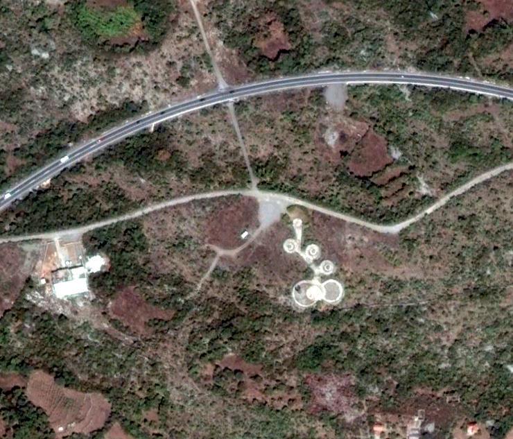
This project engages the geographically remote, as evidenced in the aerial views of monument sites in figure 5. Some sites which are quite remote host few visitors, given the lack of access via transportation and geographically remote nature of the terrain. Beyond acting as a barrier to access to some of these memorial areas, their remoteness often complicates conservation efforts.
Arguably geographic, remoteness can be apprehended as a relative idea. This sense of remoteness can be further perceived when the scars of conflict present themselves. More than two decades later,

warning signs for unexploded ordinances dot the edge of the road through the forest where landmines laid during conflict still await clearing.7 While driving, paved roads give way to dirt ones, the only warning perceptible is the erosive gradient of their disappearance and re-materialization kilometers later. This phenomenon often signals routes through villages abandoned as a result of proximity to borders and conflict during the breakup of Yugoslavia in the nineties.
LOCATING MEMORIAL SITES FROM ABROAD
Locating these sites from 8,000 kilometers was not without limitations. Monument sites were found by any means possible; combing forums and visiting the Wikipedia sites of each country. Some municipalities list these monuments as part of their tourism offerings, and others affiliated with the national park are listed on national park websites. I found some of the more obscure monuments by searching the hashtag #spomenik on Instagram, looking at the resulting images and geolocating based on map, hashtag or other information gleaned from the post. Of particular importance was finding the official name of each monument, which was necessary for later research purposes beyond fieldwork and documentation. When I could not discover sites via the above methods, I scanned google earth examining the context in search of clues that typically led to finding memorial areas from the air.
When locating memorials in this way, I looked for a combination of; clusters of small-scale structures, elements arranged in designed compositions, forms and compositions in contrast to their surrounding context, large areas of hardscape, clearings on hilltops, pathways linking elements, deserted roads, and proximity to the roadside. (see Figure 5 for a matrix of monument sites from an aerial view). When available, I would use Google Street View to find sites when tree cover or scale of the monument complicated finding from above. Street View also served as a double check method for sites found by scanning Google Earth. This form of double-checking, though rarely available, was used to keep from arriving at cemeteries or heading up the wrong, twisting mountain road while in the field. In these moments, the proximate geolocated site slipped into the unknown remote, teaching field lessons about flexibility.
There are many factors which influence how visible a monument site may be and affect how easily sites can be geolocated before arrival as well as located in the field. Factors include whether roads and pathways are maintained and well-marked with signage, if the monument is of a scale which contrasts with its context, or if it has a context which makes it highly visible, such as a hillside, clearing, or city center.
ON THE GROUND IN REMOTE LOCATIONS
I traversed borders via planned transit connections, arriving in major cities of each country and renting a car to move between the geographically diffuse field condition of the countryside, consisting of monument sites and defined point locations of the cities, towns, and villages where I overnighted.
In an age of mapped traffic, satellite images, and drone views it may be hard to believe that there are areas where GPS may be unreliable or where the Google car hasn’t photographed street view images. Navigating to a specific location mapped via GPS coordinates, Google Maps often does not understand the difference between twisting gravel mountain roads and main paved roads crossing valleys through engineered tunnels. I have been in situations where the GPS attempts to navigate off a cliff or down an unsuitable road. Though it has taken time, I have learned not to be tempted by shortcuts. These shortcuts almost always take twice as long (or longer) and navigate down roads rarely used by passenger cars.
In this particular case, proximate refers to the exactitude of GPS coordinates and knowing that a specific place exists at the end of those coordinates. It also suggests having some idea of how to get there in any normal circumstance. The remoteness sensed here is a reminder that this is not an ordinary circumstance. There comes a moment when the realization that all the Google-mapping, GPSnavigating, and even map reading may not render the site visible.
I learned not to trust the GPS system, no matter the form, as it was rendered unhelpful in regions affected by conflict in the nineties. Neither were very helpful, which lead to plenty of reroutes, some trailblazing and many roadside conversations in a combination of broken languages accompanied by a collection of hand-drawn maps. Abundant offers came from locals eager to help navigate to memorial sites. These proposals were made in part because it may have been more comfortable than explaining the exact location of the memorial site. Even having the precise coordinates of the memorial mapped did not help in some instances, especially in cases of purposeful erasure. Many sites have been de-badged7, along with any semblance of how to locate them, all but vague hints that they ever existed remain.
HUMAN INFRASTRUCTURE
When technology failed to render these sites visible, and I realized that I could not rely on it, I was left to rely on people. In the moments when I could not locate a specific memorial, I would map to the nearest town, have a coffee and ask locals if they knew how to get to the monument. This condition led to offers to help navigate to the site by joining me, driving me or having me follow them in their car. These offers were genuine and far more straightforward than attempting to explain the location of the memorial site in broken languages. Outside of the city, many conversations were facilitated through young people who spoke English. In one city, my host joined me on the drive over to the memorial, acting as navigator. We climbed the stairs to its perch, high above the city. Amidst the ruin of the monument, she shared that her last visit was over 20 years ago..
CASE STUDY 001: CENTRAL MONUMENT IN BIJELE POTOCIKAMENSKO MEMORIAL AREA
The central monument of Kamensko Memorial Area, shown in figure 4, is situated in a meadow atop a hill in the mountains between Korenica and Donji Lapac. The leftmost image was taken in the early

Figure 3: Central Monument, Kamensko Memorial Area - Archive of Nenad Gattin, early 1980s | Spomenik #13 (Korenica) - Jan Kampaners 2007 | Central Monument Kamensko Memorial Area - Author 2016
eighties and shows the monument in its heyday. Note the meadow and backdrop of trees as well as the scale of the people in this image. The central image of the unclad frame was taken post-nineties, in a different kind of post-war context, a post-Yugoslav context, and a post-destruction context. Of note, this image was only taken nine years before my visit. In 2013, I drove around the valley of Korenica looking for this monument site, but never found it. Desperate to locate it, I phoned home to see if anything more could be surfaced about its location. Kempenaers was emailed, responded the next day and stated that he had had a guide who spoke with the locals, so he wasn’t able to help locate it remotely.
In 2015, as I prepared my return to the region, I followed what seemed to be some less-than-ideal directions found on an online forum a year earlier. The area of the memorial is quite mountainous. The directions read: “It is situated near Bijeli Potoci, on the road to Donji Lapac. Turn left from the main road following the sign written on a wooden board that says Bijeli Potoci and after passing the small resting hut, turn left at the next crossing. After 500m you’ll get to the monument, that is, what’s left of it.” I followed the directions, parked my car at the crossing and began the ascent up a narrow, wooded dirt road. I carried a sense of hope that I was in the right place as I reached the crest of the hill. Today, the trees look very much like the trees in the original photograph of the monument from the 1980s. The memorial was destroyed with explosives in 1992 by the Croatian National Army. It is now a strongly symbolic anti-fascist, anti-nationalist monument as built by circumstance. The anchors which held the stainless steel forms of the original monument in place are still present, staring blankly back at the empty plinth. Now it stands as a monument to something else — to anything imaginable. It has been rumored that some people from the area used the stainless steel cladding on their own homes, in effect rendering this as a distributed monument to anti-fascism and anti-nationalism.
CASE STUDY 002: MONUMENT TO THE LIBERATORS OF KNIN
[In its heyday, the monument stood proudly above the city of Knin until it became a casualty of conflict in the nineties. For this site, I was unable to determine the exact location of the monument ahead of arriving. Instead, I had to rely on human infrastructure. I typically
ask local bartenders, restauranteurs or in small towns, locals who are out and about if they know where the monument is.
I have a hand drawn map from the owner of the restaurant Tri Lovce. As he drew this diagrammatic map, he described how to get to the monument above the city. He drew through it with me, explaining each part in his best English — take the rotor — at the first junction turn right and drive up toward the castle. Drive along the road to the right of the castle. When I arrived, I did not see any monument remnants or clues about the whereabouts of this particular monument. The castle had a restaurant, so I inquired inside about the monument. I was told to follow the street that I came up until I found a path through the forest that would last about 1000 meters and was given a bit of an eyebrow raise, as if to say not to go there. Only later did I understand that the nuance of the map initially drawn for me.
Reluctant to try an overgrown path that was barely perceptible, it was the closest signifier of an entrance I could find. All other areas had mature vegetation flush with the street. Once I began, I noticed the small amount of overgrowth and it became clear that the path was being maintained. The trail seemed to arbitrarily narrow and widen at points, but remained visible as a delineated path. Sometimes the trail would become overgrown, but the size and corresponding age of the trees can be a good indicator of where an old trail that is no longer being maintained begins and ends.
As I reached the crest of the hill, the monument came into view and became a proximate idea, with an exact location. In an effort to render it further remote by hiding it from view, the monument was toppled from its base with explosives in 1995. Figure 4 depicts the view of the monument in its current state. There has been discussion and a petition to rebuild the monument but with little funding available and money having been spent just last year on a new memorial commemorating the war in the nineties, it seems highly unlikely this will come into fruition. Today, the monument signifies new meaning about resilience in the face of obsolescence.
DOCUMENTATION
In July of 2017, I concluded my third research trip documenting memorial sites. I have now located and documented 58 monuments and memorial areas. From the beginning, this project called upon my background as a filmmaker and photographer to document the monuments to better understand their present context.
While on site, I photograph to understand how people are using the

remnants of streetlight bases offer evidence, as do parking areas at the end of such roads. Stairways and granite pavers also denote this type of memorial infrastructure.
site; taking into account signs of recreation, upkeep, commemoration and new uses. I thoroughly document paths to and from the monument as well as each elevation of the monument and corresponding detail shots of materiality as well as vegetation growing on site. I photograph the memorial and its context as I walk around it, producing a 360-degree view. I also frame views out from the monument to better understand its circumstances; is it in a park in a village, on a remote mountaintop, in a city center or overlooking a city center.
Documentation can last from one to four hours depending on the type of site — these sites exist as large-scale memorial areas complete with interpretive programming in the form of memorial houses, museums, plaques or as stand-alone roadside monuments (see figure 5 for aerial views of a variety of site types) and . Upon arrival, I begin photographing the procession to the monument from the point of entry and back out.
Monuments were often built on elevated plinths, mountainsides, or hilltops. Infrastructure is typically the first clue that a monument site is near. Paved roads in remote areas lined with the concrete
I have found that locating sites is often far more difficult than the documentation of them. My methodology has evolved to include capturing context, something I did not necessarily do when I initially embarked on this research in 2013. As I move around a site documenting, I am working to find answers to the question of why this particular site remains and how it may have changed to remain relevant in its new post-socialist context. .
REFLECTION
With each successive trip, I have learned to seek local advice to find monuments and to engage people at memorial sites. Most people are curious, and when we begin talking, I learn quite a bit about their culture and how people living nearby perceive these sites. Though I do attempt to locate as many memorials ahead of time as possible, I also realize how much has been gained regarding context when I have had the opportunity to wander off course or have reached out to locals for assistance. Between 2016 and 2017 I noticed quite a significant difference between the accuracy of the maps and the availability of apps for different regions of each country. Of note


1: Central Monument in Bijele Potoci, Croatia | Monument to the uprising of the people of Kordun and Banija in Vojnić, Croatia | Memorial Ossuary in Veles, Macedonia | 2: Memorial Park Bubanj in Niš, Serbia | Jasenovac Memorial and Museum in Jasenovac, Croatia | Makedonium in Kruševo, Macedonia | 3: Monument to the Fallen Soldiers of Lješanska nahija in Barutana, Montenegro | Monument to the Victims of Fascism in Podhum, Croatia | Stratište Memorial Complex in Jabuka, Serbia | 4: Monument to the Battle of Sutjeska and Memorial House in Sutjeska National Park, Bosnia-Herzegovina | Monument to the Revolution in Kozara National Park, Bosnia-Herzegovina | Memorial Complex Kadinjača in Uzice, Serbia
is the fact that Google Maps has extended its reach and is far better than before in more areas. Waze, another mapping app is also extending its reach and working in more areas.
On my first trip I did not plan to travel alone, but due to circumstances beyond my control, I had to. (This also marked my realization that ability to adapt to changes on the fly would be necessary to perform this work). After completing my first trip, I learned that traveling alone allowed the opportunity to absorb the context of these sites and provided the flexibility to engage locals and visit unplanned monuments. I have learned that my outsider perspective is an advantage regarding asking questions about the past. Most locals would carefully traverse their answers based on perceptions about my ethnic background and political leanings if I were from the region. As I have documented these sites, I have collected stories about the people who live among these monuments, some nostalgic for the past, others hopeful for the future. It is in these moments that these remote sites, cultures, and people become much more proximate.
Research work is ongoing and seeks to provide enough backgrounding to understand the nuance of each of these monuments in their changing post-socialist context as I work to understand the capacity of memorial elasticity.9 I hope to unearth enough of the rich historical context surrounding these sites so that future, past, and present can coexist.
ENDNOTES
1. Research was launched as part of post-grad studies pursued in Conservation. Work on this project, Spomenik in Flux, was revived at the end of 2015. Work is ongoing.
2. Kempenaers J, Neutelings WJ. Spomenik #1-26. Vol 141. Amsterdam: Roma Publications; 2010.
3. Population by Age and Sex, by Settlements, 2011 Census: Kamenska. Census of Population, Households and Dwellings 2011. Zagreb: Croatian Bureau of Statistics. December 2012.
4. Dusek R. Anti-fascist monuments: Croatia’s ‘Unwanted heritage’. http://www. balkaninsight.com Web site. http://www.balkaninsight.com/en/article/antifascist-monuments-croatia-s-unwanted-heritage--03-31-2017. Updated 2017. Accessed Oct 8, 2017.
5. Ilic I, Robinson M. Croatian leaders tread softly in face of world war two revisionism. Reuters. Fri Feb 10 16:49:38 UTC 2017. Available from: https://www.reuters. com/article/us-croatia-past/croatian-leaders-tread-softly-in-face-of-world-wartwo-revisionism-idUSKBN15P241. Accessed October 8, 2017.
6. Monument of the Revolutionary Victory of The People of Slavonia during construction circa 1960s. DobarSkroz (Own work) [CC BY-SA 3.0 (https://creativecommons.org/licenses/by-sa/3.0)], via Wikimedia Commons.
7. Current mine situation – BHMAC. Bosnia Herzegovina Mine Action Center. 2015.
8. De-badging monuments refers to the phenomenon of monuments being stripped of their commemorative meaning through removal of all identifying plaques and commemorative elements, just as a car which has been de-badged is stripped of allidentifying markings denoting make and model as well as all associated logos of maker of vehicle.
9. Lindsay E. Spomenik in Flux, Dichotomy. 2015;ODDS(21):44-58.