2023
++++++ ++++++ ++++++ ++++++ ++++++ ++++++ ++++++ ++++++ @evankriswandi P O R T F O L I O
Evan Kriswandi Soendjojo


I am a passionate architect and urban designer, graduated from the University of Sydney, under the Australia Awards Scholarship, a prestigious scholarship from the Australian Government for the next global leaders to pursue study, research and professional development. Throughout my previous study and career, I have challenged myself to explore all of my potentials and passion in architecture and urban design. I have consistently sought innovative design solutions in every project and the result can be seen in my portfolio where I have developed skills for research, design strategy, and high capacity for aesthetic resolution. My biggest dream is to use my skills and knowledge to help built happier and better cities to live, work and play for future generations.


Charles Montgomery “Happy City” 2013


 West Residence | Nusantara
Westmead 2050 | Sydney
Hi-Tech Garden City | Karawang
Kota Baru Keandra | Cirebon
The Radiant | BSD
Sustaining Granville | Sydney
MRTJ Phase 2B | Jakarta
NCC | Bali
Cisadane Waterfront | Tangerang
Oxford Street | Sydney
Simpulima | Banjarmasin
West Residence | Nusantara
Westmead 2050 | Sydney
Hi-Tech Garden City | Karawang
Kota Baru Keandra | Cirebon
The Radiant | BSD
Sustaining Granville | Sydney
MRTJ Phase 2B | Jakarta
NCC | Bali
Cisadane Waterfront | Tangerang
Oxford Street | Sydney
Simpulima | Banjarmasin
Principal: Mr. Sibarani Sofian | Founder & Director | URBAN+
Project Manager: Ms. Vallin Tsarina | Associate Urban Designer | URBAN+
Project Type: Residential Precinct Urban Design Guidelines
Client: Indonesia Ministry of Public Works and Housing
Location: IKN Nusantara (Indonesia New Capital City in Kalimantan Island)
Site Area: 90,53 ha
Period: August - December 2021

Indonesia is building a new capital city from the scratch. It is a huge challenge but also a rare opportunity to build an ideal city with the best practice standards of urban design. This project is in the phase of making urban design guidelines for one of the earliest precincts to be built, which is the residential precinct for government officials and their families. The aim is to guide the design and construction of each district, block and parcel will correspond with the ultimate vision of the IKN Nusantara master plan, which is Inclusive, Sustainable, Smart & Resilient Capital City Residential Areas. Thus, the guideline will bring the living transformation of the Indonesian people which focuses on developing quality housing that is inclusive, smart, collaborative, compact and based on the 10-minutes city concept, which also respects the natural condition of the site.


Principal: Mr. Sibarani Sofian | Founder & Director | URBAN+
Project Manager: Mr. Wagiono Bustami | Senior Urban Designer | URBAN+
Project Type: Transit Oriented Development Urban Design Guidelines
Client: PT MRT Jakarta
Location: North Jakarta
Site Area: 165.02 ha
Period: June - December 2020
This following project is a unique opportunity to transform the densely populated urban area in North Jakarta to be redeveloped as a new transit-oriented development with the advent of the new MRT line and stations. This project comprises three distinct urban design guidelines for three stations, which are Mangga Dua, Marina Ancol and Ancol Barat Final Station. But, in this portfolio, only one station is featured, which is Ancol Barat which also serves as a train depot. The site is unique because it is a compilation of a former industrial ditrict, dense ‘kampung’, private residential development and also a ‘prime’ waterfront. So the vision of this project is to create a lively, resilient and sustainable seaside transit-oriented development with ample public open space in the waterfront area to reconnect Jakartans with their precious natural surrounding, the Java Sea.


Legenda:
 Rencana Titik Stasiun
Rencana Trase MRT Fase II B Jalan Eksisting
Rencana Titik Stasiun
Rencana Trase MRT Fase II B Jalan Eksisting


Legenda:


 = View dari Stasiun ke Laut
= View dari Bangunan ke Laut = View Axis Jalan ke Laut
= View dari Bangunan ke Tengaran
= Bangunan Tengaran
Gambar 12.5.1.3 Tampak Barat KBT Ancol yang memperlihatkan Skyline Bangunan yang bergradasi semakin mendekati laut semakin rendah
= View dari Stasiun ke Laut
= View dari Bangunan ke Laut = View Axis Jalan ke Laut
= View dari Bangunan ke Tengaran
= Bangunan Tengaran
Gambar 12.5.1.3 Tampak Barat KBT Ancol yang memperlihatkan Skyline Bangunan yang bergradasi semakin mendekati laut semakin rendah


Disclaimer: Rendereing made by third party hired by URBAN+

Principal: Mr. Sibarani Sofian | Founder & Director | URBAN+
Project Manager: Mr. Wagiono Bustami | Senior Urban Designer | URBAN+
Project Type: Industrial Park Detailed Master Plan
Client: Undisclosed
Location: Karawang
Site Area: 1386.57 ha
Period: March - December 2020

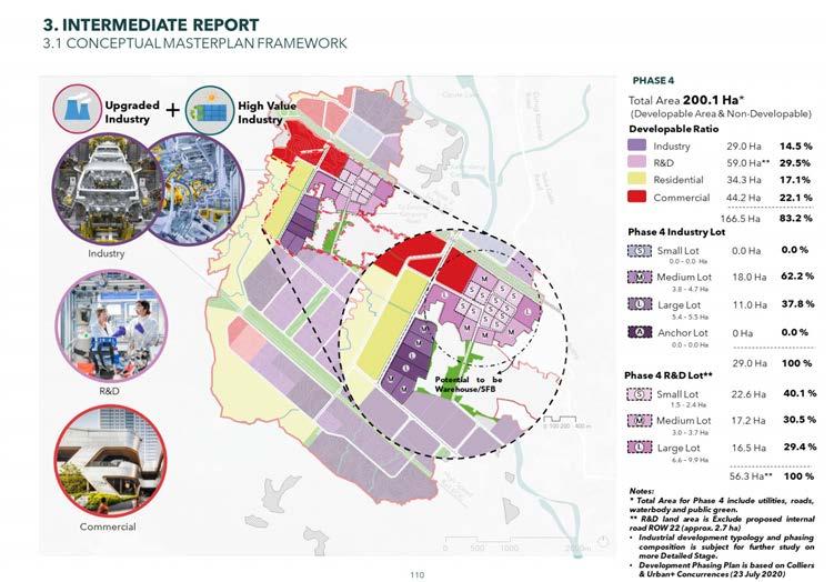
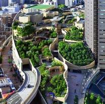
This ambitious project aims to build a new hi-tech sustainable and integrated industrial park in Karawang, West Java, Indonesia. The massive site area gives a perfect opportunity to not just develop rows of factory and warehouse buildings, but also a residential area for the workers and executives as well as commercial and recreational area for them to work, live and play in an integrated area, minimizing the need for commuting. The diversity is also applied within the industrial development itself with the mix of small, medium, and big industrial complexes and warehouses. The master plan layout and design aims to optimize the smooth circulation and the challenging contour of the site, with the vision to create an Integrated & Efficient Industrial Development with a Vibrant Neighbourhood in a Garden Setting


Disclaimer: Rendereing made by third party hired by URBAN+

Unit Coordinator: Dr. Pranita Shresta | Director of Urbanism | University of Sydney
Tutor: Mr. Rouzbeh Loghmany | Lecturer | University of Sydney
Project Type: Academic Unit of Study
Institution: University of Sydney
Location: Sydney Metropolitan Area, Australia
Site Area: 9.66 km2
Period: March - June 2019


will be an attractive and well-integrated city that celebrates nature, heritage and culture, thus catalysing sustainable growth and innovation

The following project takes a closer look at Westmead, its history, and unique characteristics and presents an ambitious strategic plan for transforming the area into a dynamic, world-class city and second CBD for Sydney. Beginning with a thorough investigation of Westmead’s context, demography, and position relative to the existing Sydney CBD, a vision is proposed to make Westmead in 2050 an attractive and well-integrated city that celebrates nature, heritage and culture, which could further catalyse sustainable growth and innovation. To achieve that vision, 5 themes are formulated, which are Economy, Community and Culture, Liveability, Connectivity and Ecology. Each theme has several objectives which are explained in details with action plans that follow.


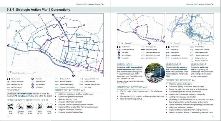
• Westmead Metro City Circle Metro with 6 stations


• North expansion of Parramatta Light Rail
• City circle bus routes

• More frequent bus routes serving east and west residential areas
• Connection to Sydney Metro West and Northwest Link
• Proposing community-based living


• New research centre for Westmead
H&E precinct expansion
• Dedicated key-workers and student accommodation

• Existing school expansion
• Tree canopy improvement
Art & Innovation Hub
• Redevelop light industrial land
• Low-rent spaces for artists and start-ups

• Expansion of community-based living

• New theatre
• Many events and programs
North Parramatta
• Connected with more frequent bus routes
• Connected to Parramatta Lake
• New school
Economic Priority Area
Westmead H&E Precinct Expansion
Local Centre
Night Time Economy
Art & Innovation Hub Precinct
Enhanced Cultural Programming

Multilingual Signage Pilot Area
Heritage Adaptive Reuse
Westmead Botanic Garden
Special Cultural Buildings
Artist Studio and Start-ups Office
High Density Housing
Medium Density Housing
Urban Farm
Key-workers & Student Accomodation
New School Expansion
Community-based Living
Westmead Transport Hub
Light Rail
New Bus Routes
Metro City Circle

Sydney Metro West
Sydney Metro Northwest
River Revitalisation
Parramarra Park Revitalisation
Endangered Vegetation Protection
New Park
New Habitat for Flora & Fauna
Existing Green Space
Urban Heat Island Mitigation

Swale Graden
Tree Canopy Improvement
Pedestrian Access to Parramatta Lake
Unit Coordinator: Ms. Deena Ridenour | Senior Lecturer | University of Sydney
Tutor: Mr. Ben Nacard | Senior Associate Urban Designer | Oculus
Location: Granville, Sydney Metropolitan Area, Australia
Project Type: Academic Unit of Study
Institution: University of Sydney, City of Parramatta, Cumberland Council
Site Area: 332,045 m2
Period: August - November 2018

• Granville is located in the south east of Parramatta. In the recent council amalgamation, the precinct is divided into two councils. The northern part of the railway is included in the City of Parramatta Council, while the Southern part belongs to the Cumberland Council. This becomes a constraint for formulating an integrated plan for the whole precinct because each council has its own plan.
• The location makes Granville the first precinct that is included in the Parramatta Road Corridor Plan.
• There are four major destinations surrounding Granville which could potentially attract people to visit or live in Granville, which are the Parramatta CBD, Sydney Olympic Park, Auburn Botanic Garden and Merryland Town Centre.


Integrated north and south town centres by connecting diverse small centres into one big prominent centre with a distinct identity and a sense of community that the residents proudly to call ‘HOME’
To create an integrated town centre with a unifying character of the place


 To connect Good St and South St with direct pedestrian link.
Council Boundary
Town Centre Boundary
Rail Line
Existing/New Bridge
Heritage Buidlings
Active Frontages
New/Improved Through Site Links

Existing/Proposed High-Rise
Existing/Proposed Medium-Height

Existing Low-Height
New Shared Space
New Plaza Over Railway
Mixed-use Development

New Car Parking
New Green Space
Existing Basketball Court
Residential Boulevard
New Pedestrian Boulevard
Improved Creek Corridor
Existing/New Pedestrian Crossing

Rooftop Gardento create amenity for high density


Total Area : 332,045 sqm
Residential Yield : 766,005 sqm
Non-residential Yield : 329,375 sqm
Open Space Area : 95,556 sqm
Community Use : 20,472 sqm

Total Dwellings : 8,511 dwlg
Total Jobs : 13,175 jobs
Granville has a big problem. It is divided by a major railway, LGA borders and unconnected plans on both sides of the railway. So the brief is to make an integrated precinct with one unifying vision for Granville that balances the future needs for growth and the preservation of local heritage and unique low-rise suburban character of the precinct. The design approach includes urban densification, mixed-use integrated transport oriented development, maintaining fine urban grain, preserving the urban heritage and upgrading the local park into a regional park with greater amenities for a better quality of life.
Unit Coordinator: Ms. Gabriela Fernandez | Senior Urban Designer | City of Sydney
Tutor: Dr. Pranita Shresta | Director of Urbanism | University of Sydney
Location: Sydney, Australia
Project Type: Academic Unit of Study
Institution: University of Sydney
Site Area: 81.23 m2
Period: March - April 2018


Mix Land Use
Vehicle Domination
Late Night Management
Closing Stores

Preserving Heritage


Divided Squares

Unique Community
Lack of Green Space


Relatively Small Blocks

Lack of Shades
Oxford Street is one of the unique streets in Sydney with distinct characters and charms. One factor that contributes to its liveliness is the mix land use that could generate diversity from the commercial, cultural and residential area. Nevertheless, there are some discernable problems such as vehicle domination, lack of green space and lack of shades to protect people from the weather condition. Therefore, the vision is to enhance the vibrancy and liveliness of the whole Oxford Street by integrating Oxford Street as one ‘Shared Space’, adding more green space area and applying urban art as shades. The shared space may claim the street from vehicle domination to pedestrians which would unite the street as a place and thus make people move around from one part to another more easily. Adding more green space area would enhance the liveliness and aesthetic of the street as well as providing the shades from sun heat. Applying urban art as shades in the squares would also activate it in unfriendly weather condition, thus inviting people to spend more time in this place, rather than just passing by.

To enhance the vibrancy and liveliness of the whole Oxford Street at the various times of day by these three key objectives:
2. Adding More Green Space Area

1. Integrating the Oxford Street from Crown St. to Comber St. as one ‘Shared Space’


3. Applying Urban Art as Shades


Green Space
Vertical Garden Recommendation
Adding Trees Recommendation
Canopy Recommendation

Landscape Nodes
Shared Space

Public Plaza
Pedestrian Network


Principal: Mr. Ari Widio Prihananto | Principal | Monokroma Architect
Collaborator: Mr. Dadan Adriansyah | Urban Designer | Rupaidea
Project Type: Consulting Work
Client: PT. Tulus Asih
Location: Cirebon, West Java, Indonesia
Site Area: 100 ha
Period: January - December 2017


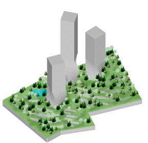
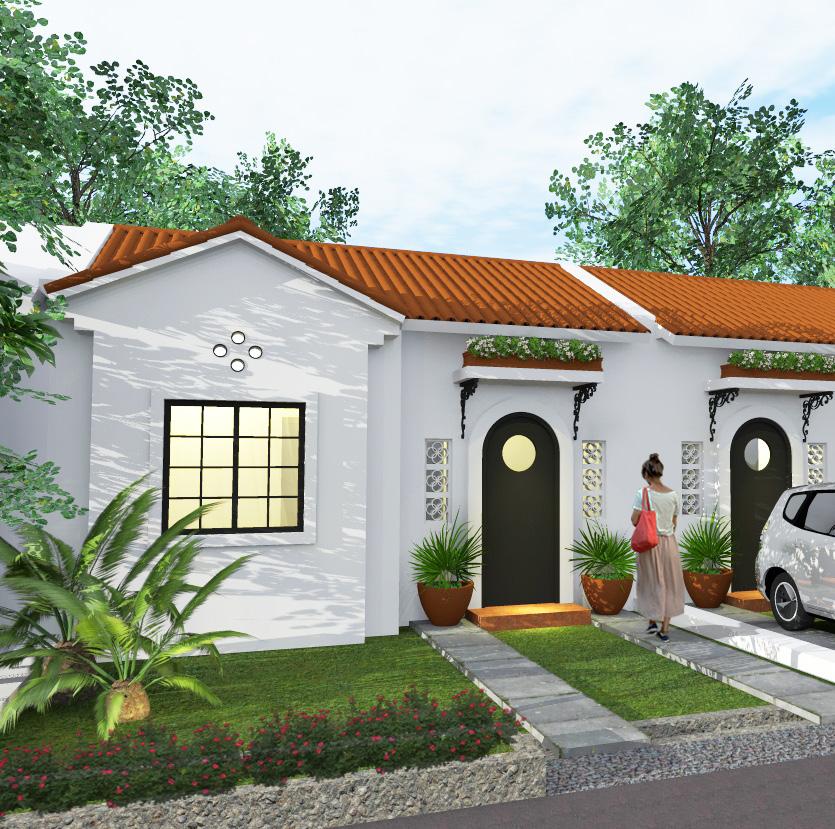
This is a new integrated residential development in the outskirt of Cirebon. This new complex will host subsidized housing as well as commercial housing for middle-class families along with its public facilities. The city of Cirebon is growing and drawing more people from the surroundings. There is a significant demand for landed houses. A progressive developer in Cirebon wants to meet those demands and has an ambitious vision to acquire up to 100 hectares of land to develop a new residential complex with a unique concept. Located just beneath the mountain, the site has challenging contour. There is a grand entry statement at the front to welcome the visitors before they see a stunning farm and hill scenery. The masterplan will be fulfilled by lavish greenery to create a resort ambience.


Principal: Mr. Ari Widio Prihananto | Principal | Monokroma Architect
Collaborator: Mr. Andreas Yanuar Wibisono | Lecturer | Universitas Pelita Harapan
Project Type: National Competition
Organiser: South Kalimantan Government
Award: 4th Prize
Location: Banjarmasin, South Kalimantan, Indonesia
Site Area: 904.04 m2
Period: October - December 2017


This is a national competition to design a landmark in the centre of Banjarmasin city that was the location of the old governor office building. This venue is intended to become a new landmark to attract more tourists to the city. The old governor office which sits on the site will be preserved as a heritage building. The site is near the Martapura river which has great potential to be integrated with the design, but a busy street separates the site with the river. In the larger context of Banjarmasin, the city lacks attractive tourism venue, so it is a great potential to design something stunning for the city which will make the citizen proud of their hometown. The design proposes a monumental design concept in a sculptural form of a sleek tower rising from the water 80 meters into the sky. The form symbolises the five historic rivers that formed Banjarmasin in the beginning. A viewing platform in the sky so people will be able to see the city edges as the city grows. This venue will integrate the old governor office as a museum, as well as add a new amphitheatre for cultural performance, a culinary centre, and the biggest urban park in the city. It will be an amazing public space for the people of Banjarmasin.


Principal: Mr. Ari Widio Prihananto | Principal | Monokroma Architect
Collaborator: Mr. Andreas Yanuar Wibisono | Lecturer | Universitas Pelita Harapan
Project Type: National Competition
Organiser: PT. Jimbaran Hijau
Award: 2nd Prize
Location: Jimbaran, Bali, Indonesia
Site Area: 36,180 m2
Period: October - December 2016

Bali is rich in local culture that is very attractive to the international world
The philosophy of Bali is reflected in its ornaments, zoning, architecture, and rituals that always remind Balinese of its historical roots.
The traditional values of Bali becomes the basic principle for its society, preventing it to lose its identity in the midst of technological advancement
The population and information distribution becomes easier nowadays. It makes universal values distibution unavoidable

The development of civilization is always preceded by the development of the imagination. Architecture can learn from the values of the past, but must also contribute to provide many possibilities for the future.
Rapid technological developments influence the way society thinks. Architecture should be able to follow these developments.

Complex Enclosed

Ornamental Historic Platform Simple Open plan
Bare
Futuristic
2nd & 3rd Floor:
Museum of Nusantara
Art and Culture
1st Floor:


Museum Soekarno
1st & 2nd Floor: Exhhibition room with optimum lighting
Ground Floor:

Museum of Modern Art
Ground Floor: Exhibition opening, discussion room, exhibition room with more open space
Amphitheater is the core that blend dichotomy of traditional and modern values, between spectators and performers
1st Floor: Indoor Theater
Utama Museum Madya Nista Gallery Amphitheater Theater Head Body Leg
In every building, visitors can feel the change from modern to traditional ambience using vertical circulation

Platform
Traditional ambience
Visitors feel authentic Balinese Ambience
Ground Floor Modern Ambience
Visitors feel Balinese modern ambience

Basement Service Area


This competition invites architects to design a new art and cultural centre in the heart of Jimbaran that reflects the richness of Balinese architecture alongside contemporary design style. A developer in Bali wants to preserve and promote the local Balinese culture by designing a new art and cultural centre for young people from around the world to learn and practice the richness of Balinese culture in a contemporary way of promoting popular culture. The design proposes a concept that confronts old traditional values with modern imagination in one place. With an open platform, the contemporary style on the ground floor is separated from the Balinese style in the first and second platform. The intention is to make the complex looks traditional from afar or bird-eye-view, but when people enter the ground floor, they are suddenly welcomed by very contemporary architecture and interior. When they go up, the will once again feel the exotic Balinese village ambience. The master plan is arranged according to “Sanga Mandala”, an ancient Balinese principle of home master planning. The modern part is an open plan and always be flexible to change, while the traditional part will always be preserved as a remembrance of its cultural richness.

Supervisor: Mr. David Hutama | Department Head | Universitas Pelita Harapan
Project Type: Undergraduate Final Project
Institution: Universitas Pelita Harapan
Award: Finalist | National Final Project Competition | ITS Surabaya
Location: Jakarta, Indonesia
Site Area: 10,000 m2
Period: August 2014 - July 2015


This final project intends to create variations of spaces and rooms which could be explored by the users. The main target user of this hotel is the ‘Bourgeois Bohemian’ people. It is the term coined by American sociologists David Brooks in his book “Bobos in Paradise: The New Upper Class, and How They Got There” in 2000. They are new the upper class in urban societies with high income and high education who has specific characteristics. After summarising those characteristics, the programs of space, site criteria, and design guides are derived. Those parameters then guide the evolution of form and programming of this five-star hotel. The challenge is how to accommodate those specific requirements alongside the complex standards of five stars hotel as well as public regulations and environmental concerns in Jakarta.


Supervisor: Mr. Realrich Sjarief | Principal | RAW Architecture
Project Type: National Student Competition
Organiser: PT. Sinarmas Land
Award: 2nd Prize | Masterplan Category
Location: BSD City, Banten, Indonesia
Site Area: 180,000 m2
Period: July - September 2014


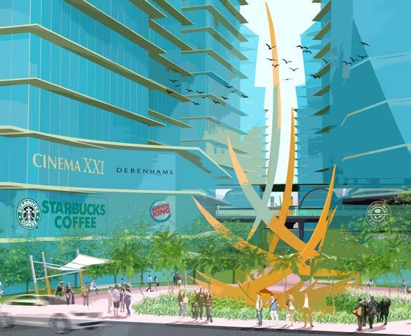
This competition invites young architects to design a masterplan of a central business district of new development on the outskirt of Jakarta. The developer running this competition wants to develop the prime piece of land as the CBD. With 5 Floor Area Ratio but only 15 floors maximum height, this competition seeks a design that could optimize the economic value as well as aesthetic and environmental objectives. The master plan is designed to make the area as the brightest spot in BSD City to attract as many people who pursue a brighter future. The Radiant determines to create an exuberant space, full of life and vitality with large open space area so that the office workers could easily refresh themselves at lunch or after works and interacting with people around the area. The masterplan is carefully composed to enhance delightful working, living and recreational experiences. It envisions to be the crown jewel of the BSD City as well as the grand entrance to the region.


Unit Coordinator: Dr. Susinety Prakoso | Lecturer | Universitas Pelita Harapan
Tutor: Dr. Bagoes Wiryomartono | Lecturer | Universitas Pelita Harapan
Project Type: Academic Unit of Study
Institution: Universitas Pelita Harapan
Location: Tangerang, Banten, Indonesia
Site Area: 320,000 m2
Period: January - April 2014


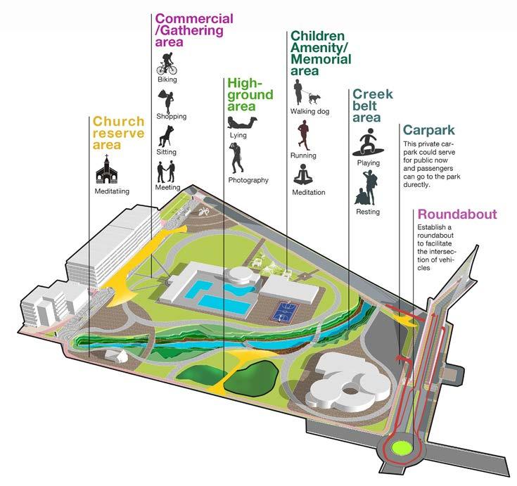
This is an urban design project for the revitalisation of a riverbank to create a new urban centre for vibrant public space, thriving commercial area, and centre of art and culture. Urban life in greater Jakarta area is now concentrated mostly in the shopping malls. Consequently, malls are becoming too crowded especially on weekend. This project aims to offer an alternative of a safe and interesting public space for mingling, socialising and trading. In 32 ha area, a masterplan of waterfront complex is designed with a waterfront dining district, landed townhouses, high-rise condominiums, offices, shophouses, luxury houses and a grand convention hotel.

NODES 1
The Marina is developed to become moreplayful & intersecting


NODES 2
NODES 3
NODES 4
NODES 5
The long frontline of the waterfront with identical shophouses can cause boredom and dissorientation. People could have difficulty to locate where they are. To solve this, some nodes are created, which are a Marina, an Amphitheater, a Skateboard Track, a Floating Restaurant, a Pedestrian Circle Walk and a Perfomance Stage.

Marina simplified and refined
Some greeneries are generated in the middle of the plaza based on the pattern line to place some trees as natural shades and some benches for the people to rest


The twisted shophouse arrangement intends to respond to the site and surrounding nodes and also serves as visual effect on the joint of the twisted building blocks.
 The Skateboard Track is omitted in the second skecth because it blocks view from the shophouses to the river
Standart linear shophouses arrangement
Pedestrian bridge to the mainstreet
The Skateboard Track is omitted in the second skecth because it blocks view from the shophouses to the river
Standart linear shophouses arrangement
Pedestrian bridge to the mainstreet
Initially the parking lots are planned in front of the shophouses. But, when the arrangement is changed to organic curve, the number of the parking lots decreases because of the irregular form. The solution is making a basement for parking so that the gound floor could be utilized for outdoor cafes
This shophouse block is parted by the pedestrian bridge so it is omitted in the next phase of the draft
The Skateboarding Track is provided again with larger site so there will be more tracks. This place functions as public facilities for youngsters from the neighbourhood to play and socialize


The street form corresponds to the organic shophouse arrangement
Stiff linear arrangement will look not resounding the form of the river as the site. So the masterplan is composed in an organic shape. It is intended to be more communicative with its surrounding and smoothly blending with other elements of this masterplan.


