

City of Wheeling Comprehensive Plan Update


City of Wheeling Comprehensive Plan
Mayor of Wheeling
City Manager
Assistant City Manager
WHEELING CITY COUNCIL
Ward 1
Ward 2
Ward 3
Ward 4
Ward 5
Ward 6
WHEELING CITY STAFF
Building & Planning Director
Development Director
Parks & Recreation Director
Marketing & Community
Relations Specialist
Denny Magruder
Robert Herron
William Lanham
ACKNOWLEDGMENTS
Tony Assaro
Ben Seidler
Connie Cain
Jerry Sklavounakis
Ty Thorngate
Dave Palmer
Brenda Delbert
Nancy Prager
Rochelle Barry
Michele Rejonis
WHEELING CITY PLANNING COMMISSION
Chariman
Jeremy West
Michael Baum
Thomas Conner
William Lanham
Howard Monroe
Ben Seidler
Christina Schessler
William Schwarz
CONSULTANT TEAM
evolve Environment :: Architecture
Details Reviewed LLC
The Wheeling Forward 2034 Team would like to thank municipal staff, our public, private, nonprofit, and institutional partners for your support and participation in the Comprehensive Planning process. Also a special thanks to the generous hosts of our Community Workshops - West Virginia Northern Community College, Wheeling University and the White Palace at Wheeling Park.
COMPREHENSIVE PLAN STEERING COMMITTEE
Robert Herron
City Manager
Jeremy West
Planning Commission Chair
Michael Baum
Planning Commission
Howard Monroe
Planning Commission
Stephanie Hockenberry Ohio County Development Authority
Olivia Litman
Wheeling Convention & Visitors Bureau
Scott Schenerlein
Wheeling Heritage
Elizabeth Paulhus Community Foundation
Valerie Piko
Regional Economic Development
Wendy Scatterday Scatterday Architecture

FOREWORD
On behalf of the Wheeling City Council and the Administration, it is with great pleasure that we present the Wheeling Forward 2034 Comprehensive Plan, a collaborative vision for our community’s future. This plan serves as a roadmap for growth and development, reflecting our shared values and aspirations. Over the past year, we have engaged with residents, business and community organizations to gather inut and insights on what they would like to see in the Friendly City going forward. Those voices have shaped this plan, ensuring it addresses the unique needs and opportunities of our city. Wheeling Forward 2034 outlines our goals for housing, transportation, economic development, sustainability and public services. It is designed to guide our decision-making and investments over the next 10 years, fostering a vibrant and inclusive community for all.
Wheeling has a tremendous history and while we want to preserve that, it is important that we forge a path that focuses on where we want to be. Wheeling has gained significant momentum in revitalization, and we look to our future with tremendous optimism. We believe this strategic vision will enable our community leaders to acieve many of the initiatives and goals laid out in these ages. With a combination of calculated decisions and partnerships we will guide Wheeling Forward. While much more work remains, we hope that you will recognize Wheeling as a flourishing city on the move. We encourage you to explore the plan and stay involved in its implementation. Together, we can build a brighter future.

01
INTRODUCTION
How do we leverage our legacy while remaining competitive in a rapidly changing world?


The city of Wheeling’s 2024 Comprehensive Plan will be a pivotal document enabling the community to innovate and respond to national and international trends. Comprehensive planning is a collaborative planning process that builds consensus among many voices as cities decide how to take advantage of new resources and navigate a pivoting community.
The City’s Planning Commission with support from department staff in partnership with residents and stakeholders have created a comprehensive plan that provides the framework for city-wide investment. Wheeling’s plan serves as a guide for orderly growth and change and provides a rational basis for future investment, planning and zoning decisions.
Envisioning our Places
Through the comprehensive planning process, we have come together to envision a shared future for Wheeling. We see a future where the city thrives with a revitalized downtown, strong neighborhoods, and a resilient environment. Cultural amenities, recreation, and natural resources will contribute to the city’s tax base, while cultural and educational institutions play a vital role in supporting an economically robust future. Wheeling’s great neighborhoods will flourish, with attention given to all areas of the city.
As part of this process, we analyzed regional data and listened to the needs of each neighborhood to identify opportunities for the next decade. We identified where the city’s assets, access to funding, or other programs can be leveraged, and where public investment can attract private dollars. Additionally, we pinpointed areas where processes can be streamlined to ensure high-quality outcomes.

Wheeling Heritage (City of Wheeling)
We are working towards a
VISION FOR THE FUTURE

Wheeling, WV is a community of choice where forward thinking and collective action offer a high quality of life, ensuring equitable prosperity for all.


Welcoming City a city where people feel connected
Resilient City Innovative City a city building new on solid foundations a city bouncing back and moving forward
We are a city of
NEIGHBORHOODS

We are a city of SYSTEMS
CULTURE
The City of Wheeling is alive with self starters who inspire others through their craft and innovation.
HOUSING
The City of Wheeling is building community with walkable, historic, and sustainable neighborhoods.
Ohio River Communities
Revitalizing Ohio River neighborhoods by connecting communities to Wheeling and beyond.
Wheeling Creek Communities
Strengthening community ties with the Wheeling Creek at heart.
DEVELOPMENT
The City of Wheeling is a growing destination that can accommodate local and regional activity.
MOBILITY
The City of Wheeling is a regional center that builds connections between people businesses and institutions.
ECONOMY
The City of Wheeling is a partner for people and industry realizing their full potential.
RESILIENCE
The City of Wheeling is prepared for any challenge through reliable networks of support and infrastructure.
vision for the future WHEELING FORWARD
Wheeling, WV is a community of choice where forward thinking and collective action offer a high quality of life, ensuring equitable prosperity for all.
The purpose of a comprehensive plan is to help guide the future development of the community over the next 10-20 years. Central to that guidance is the overall community vision, which forms the foundation of the goals and initiatives in this plan. The following is the vision statement developed from the contributions of the many people involved in this planning process that succinctly summarizes the direction Wheeling wants to go over the lifespan of this plan.

Welcoming City a city where people feel connected
The City of Wheeling stands as the center of regional commerce, its influence propelled by a growing population, a compact urban core, and increasingly accelerated urban expansion. People, businesses, and institutions can connect and communicate regularly and effectively.
Wheelin Festival (City of Wheeling)

Resilient City a city bouncing back and moving forward
The City of Wheeling is structured to meet its daily challenges as well as deftly navigate unplanned climate challenges such as landslides and floods. Its adaptivity enables commercial and cultural vitality and this propels the city forward.

Innovative City a city building new on solid foundations
The City of Wheeling, known for its cultural richness, boasts historic architecture, picturesque parks, extensive trail networks, a burgeoning arts scene, and has become a center of cultural vibrancy. All are invited to share in and help uphold the rich culture, history, and sense of community.
Wheeling island Flood Wall (City of Wheeling)
City of Wheeling Downtown (City of Wheeling)


The Ohio River (Convention and Visitors Bureau)
Oglebay Park (Convention and Visitors Bureau)

We are a city of
NEIGHBORHOODS
FULTON INDUSTRIAL HUB
This area preserves the city’s traditional industrial legacy and serves as an employment hub for makers and innovative start ups.
UNIVERSITY VILLAGE AT NATIONAL ROAD
Rich with educational assets this area connects multiple commercial centers that could bring together young innovators and enterprises with local residents.
ELM GROVE BUSINESS DISTRICT
This commercial corridor is ideal for a traditional walkable retail that leverages the Creek and historic road as a place of connection.
Wheeling’s comprehensive plan designates neighborhoods as river communities or Creek communities to highlight shared opportunities and challenges.


WHEELING ISLAND DEVELOPMENT
Wheeling Island serves as the city’s greatest opportunity for affordable residential unit production with a regional draw on the southern end.
RIVER COMMUNITY VISION. Revitalizing Ohio River neighborhoods by connecting communities to Wheeling and beyond.
Creek COMMUNITY VISION. Strengthening community ties with the Wheeling Creek at heart.
DOWNTOWN TO CENTRE MARKET
Downtown to Centre Market can be a district of destinations, including river and Creek attractions.
WARWOOD COMMUNITY CENTER
An expanded commercial core connects to the riverfront and offers public spaces for the community to gather.
SOUTH WHEELING MAINSTREET
This commercial corridor is ideal for a traditional walkable retail and civic institutions for local residents but also as a hub for start ups and makers.


REGIONAL BUS STOP

COMMERCIAL BUILDINGS

We are a city of
SYSTEMS
CULTURE
Retain our emerging local talent with opportunities to stay in the city.
Attract professionals and families into the city.
Strengthen our involvement in the creative production of the arts and our craftsmanship.
DEVELOPMENT
Support a daytime to nighttime economy in the downtown historic districts.
Create a clear process for the preservation of underutilized properties. Expand the activities around institutional campuses to accommodate broader community needs.
DOWNTOWN RIVERFRONT
The city can double down on its promise as a river town by activating both sides of the river with new investment along the water that enables more recreational and cultural offerings.
RESILIENCE
LANDSLIDE MITIGATION
A proactive approach to climate related issues allow for the city to fully engage with its unique environmental assets.
MOBILITY
TRANSIT VILLAGE
Pedestrian-friendly mixed-use communities designed around transit access and mobility choice.
ECONOMY COMMERCIAL BUILDINGS
There are several economic nodes across the city that provide employment opportunities. By expanding both the geography and permitted building types the city can support the next generation of innovators and entrepreneurs.
City-Wide Systems are the essential components or topic areas that make up a comprehensive plan and contribute to accomplishing our desired outcome.
ECONOMY
Attract high-paying jobs with the potential for growth into the region.
Attract businesses in key industries. Support growth among local and entrepreneurial business start-ups.
HOUSING
Provide housing choices for younger and senior populations who want to own.
Provide quality places to live that remain affordable for the city’s early adopters. Preserve the historic character of the city’s existing housing stock.
MOBILITY
Maintain the quality of our infrastructure.
Support the safe passage of people who travel without a car.
Improve connections to regional networks and destinations.
RESILIENCE
Improve the health of our environmental assets.
Improve access to essential services.
Improve access to our quality parks and recreational amenities.
critical issues
WHEELING’S PAST AND FUTURE

In the
Northern Panhandle of
West Virginia, Wheeling has long been an innovator in the infrastructure of cities and a springboard for economic expansion.
Wheeling’s prime location at the intersection of the Ohio River, the National Road (via the groundbreaking Wheeling Suspension Bridge), and the Baltimore and Ohio Railroad positioned the city as a vital hub and the first capital of the newly formed state. The Northern Panhandle became a key passageway between Pittsburgh, PA, and Columbus, OH, and served as a gateway for the nation’s westward expansion.

1859 First Capitol Building for WV Credit: Ohio County Public Library
The city’s earliest non-native settlements grew where the land naturally flattened, with Downtown and Wheeling Island among the oldest neighborhoods. These areas developed around major manufacturing centers like the Riverside Iron Works and Top Mill, as well as the retail and service industries that supported the booming labor force. Most of the city’s historic buildings and infrastructure were constructed between 1900 and 1940, and Wheeling’s distinctive architectural character is a lasting legacy of that era of investment and growth.
The Contributions of Many
Many people shaped Wheeling’s legacy, including the Native Americans whose settlements influenced the location of European communities and routes. While the stories of Western European immigrants are often told as part of the history of industrialization, other narratives are less familiar, such as those of Africans brought to the region as enslaved people, considered the legal property of
Wheeling’s “first families.” Their labor contributed to the building of Wheeling, and their resistance played a role in the history of emancipation, despite West Virginia’s alignment with many southern states during Reconstruction1.
Economic Challenges and Historic Grief
Manufacturing played a crucial role in Wheeling’s history, but like many legacy communities, the city felt the impact of America’s decline in the manufacturing sector. During that time, globalization and U.S. economic policies allowed investors to move capital to regions with lower overhead costs and cheaper labor. At the same time, there was a decreasing demand for coal, a key export for the state. Although coal continues to provide livingwage jobs in Wheeling, its reduced demand has strained the local economy.


1 Duffy, Sean. “Wheeling’s 20th Man: 250 Years of Race Relations in the Northernmost Southern City of the Southernmost Northern State,” 23, June 2020. Archiving Wheeling
A map depicting the economic status of counties within the ARC’s service area as of fiscal year 2024.
Credit: Appalachian Regional Commission
Endangered building owned by the City Credit: Preservation Alliance of West Virginia
As industries moved overseas, many manufacturing jobs disappeared with them, leaving communities struggling to shift toward new industries that could sustain their populations. Property owners found it difficult to maintain their buildings, businesses struggled to stay open, and residents left in search of better opportunities elsewhere. The region’s overreliance on coal, combined with reduced investment in healthcare and education, made it challenging for new families to find opportunities for growth.
A Shift in Economic Focus
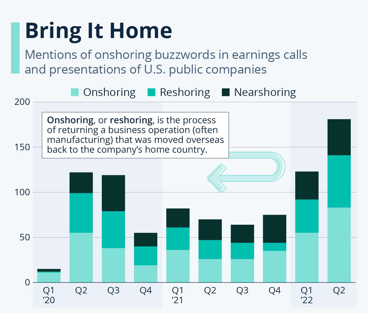
Today, both Wheeling and West Virginia recognize that to move forward, they must take control and actively shape their desired future. A growing trend of reshoring jobs, particularly in additive manufacturing, is emerging due to advancements in technology and the rise of e-commerce. The city is transforming its historically industry-driven waterways and regional connections into a network of trails and new ecological links.The state continues to strike a balance between attracting large industries, supporting local entrepreneurship, and improving infrastructure.
As part of the Appalachian Regional Commission’s efforts, West Virginia has outlined key investment priorities in its State Appalachian Development Plan and Annual Strategy Statement:
• provision of basic infrastructure such as water and wastewater (highest priority)
• industrial and commercial site development
• addressing abandoned and dilapidated buildings
• workforce development, including re-entry into the workforce for individuals with substance use disorders (SUDs).
Looking to the Future
The community’s demographics have been trending upward, and Wheeling is working to build on this momentum by creating an inclusive environment for everyone. This includes offering diverse housing choices, improving mobility options, expanding cultural and recreational opportunities, and attracting jobs that provide living wages. Decades of successes and challenges alike will shape this new comprehensive plan, as Wheeling redefines what it means to be a twenty-first-century legacy city.

Banner unveiled during the 2024 State of the State address by State highway workers (West Virginia Infrastructure Hub)
Public Companies push towards onshoring (Bloomberg)
City of Wheeling Demographic Trends
Wheeling is experiencing a slower population decline compared to its metropolitan statistical area (MSA), with a balanced flow of people moving in and out of the region, though slightly more are leaving. The city’s population is aging, with an increase in share of older adults and a decline in younger families and the workforce. Wheeling has a higher proportion of households with individuals aged 65 and over, as well as people living alone, while it has fewer households with younger married couples and families with children. Despite these trends, Wheeling remains a key job center in its region, largely due to WVU Hospital, the state’s largest employer.


ABOUT THIS PROJECT
A Comprehensive Plan describes a community vision and outlines the steps needed to make the vision a reality.
Comprehensive plans provide recommendations to help leaders guide future growth and development by outlining how land should be used. More than just a document of past and present land use trends, a comprehensive plan serves as a tool to align businesses, residents, and organizations around a shared vision for the future.
As required by WV State Code §8A-3-4, Wheeling’s comprehensive plan update is a written statement
on current and future land use and development patterns. It includes descriptive materials such as text, graphics, and maps, detailing the objectives, principles, and guidelines for the orderly and balanced economic, social, physical, environmental, and fiscal development.
A comprehensive plan update must meet the following WV State Code objectives:
• A statement of goals and objectives for City Council, concerning its present and future land development;
• A timeline on how to meet short and long-range goals and objectives;
• An action plan setting forth implementation strategies;
• Recommend to City Council a financial program for goals and objectives that need public financing;
• A statement of recommendations concerning future land use and development policies that are consistent with the goals and objectives set forth in the comprehensive plan update;
• A program to encourage regional planning, coordination and cooperation with other governing bodies, units of government and planning commissions;
• Maps, plats, charts and/or descriptive material presenting basic information on the land included in the comprehensive plan update, including present and future uses.
A Reference Document for Grant Writing
Regional funders prioritize projects that show potential for broader impact. This Comprehensive Plan incorporates specific, community-vetted strategies within a larger development framework. Grant writers can use the plan’s text, graphics, and data to pursue funding for implementation.
A Plan for Future Action
Throughout this process, we discovered many individuals doing important work for the community, often without prior connection to one another. This Comprehensive Plan provides a broad framework for collective action while being specific enough to guide individual efforts, offering clear opportunities for coordination and partnership.
An Advocacy Tool for Community Oriented Development
This Comprehensive Plan highlights priorities, projects, policies, and programs that are data-driven and have earned community consensus. Community organizers and stakeholders are encouraged to use this report as a tool when advocating for the types of development they want to see in future discussions.
NAVIGATING THE PLAN
Section 01
INTRODUCTION
This section articulates the vision and values that are synthesized from community conversations, the overall plan proposal and describes how and why the planning process has been undertaken.
Section 02
CITY-WIDE SYSTEMS PLANNING
The six city-wide systems represent the key components of the comprehensive plan. Each system includes one overarching goal, three objectives, and an implementation plan with action-oriented initiatives, partners, and timelines to help achieve the desired outcome. For four of the systems, there is a high-priority, city-wide strategy featuring solution typologies that can be applied across the city, along with recommendations for impactful locations.
City-wide systems chapter include:
CULTURE DEVELOPMENT
ECONOMY HOUSING MOBILITY
RESILIENCE
Section 03
NEIGHBORHOOD PLANNING
This section connects Wheeling’s neighborhoods with its waterways and introduces city-wide placemaking and investment strategies, along with specific recommendations for high-priority districts. These recommendations address current character, places, policies, and programs that could meet community needs, and how potential changes could enhance the overall functioning of the city. Seven priority districts have been identified, where multiple infrastructure and development opportunities intersect.
APPENDIX
The Appendix includes progress summaries and technical report documents including:
Wheeling’s waterway communities include:
OHIO RIVER COMMUNITIES
WHEELING CREEK COMMUNITIES
making the plan
ABOUT OUR PROCESS
We believe that broad engagement leads to effective implementation. Throughout the process, we focused on ensuring diverse participation, both in our outreach efforts and in the plan’s development.
Wheeling’s identity is shaped by both its community capacity and the circumstances in which it operates. Strong communities like Wheeling adapt to their unique social, economic, and environmental conditions, which in turn shape their culture and identity. To manage change effectively, these communities also rely on clear decision-making, organizational learning, legal frameworks, and financial resources—key tenets of this plan that will strengthen Wheeling’s sense of identity. The comprehensive planning process brought community leaders together to collaboratively shape the city’s future while developing core principles. This collaborative approach is expected to continue throughout the implementation of the plan.
Community Conversations
This three-part planning process was the community’s opportunity to shape municipal priorities for the future. The purpose of each community conversation was to introduce the project, share progress made in the three communities, and gather input on strategies for moving forward.

14
Interviews and Focus Groups were held with members of leadership, regulatory agencies, land and property owners who have an interest in what goes on in the city.
10
Action Plan Workshops gathered teams of local and regional experts to discuss the opportunities and challenges when addressing city-wide issues.
3
Public Meetings and Surveys were conducted across the city to gather feedback and context around Wheeling’s most pressing issues and critical issues that this project needs to address.
City of Wheeling Staff kick off the Comprehensive Plan process by constructing a map of stakeholders and develop an outreach plan for the project.
Credit: Consultant Team
At community meetings, residents, stakeholders, and experts shared information and worked together to plan the city’s future. Data and lived experience clarified concerns to inform collective decisions.


ONE ARTICULATING A VISION
NOV 2023 - FEB 2024
OUTCOME: A shared understanding of city-wide critical issues and project goals clarity about the process to get to the finish line.
TWO DEVELOPING A PLAN
FEB 2024 - MAY 2024
OUTCOME: Preliminary recommendations and projects in the community that synthesize values and support community goals.
THREE
DEEPENING PRIORITIES
MAY 2024 - AUG 2024
OUTCOME: A series of projects or ideas poised for future action, including potential funding, partners, and a time frames.
DELIVERABLES
• Engagement and Outreach Plan
• Existing Conditions Analysis
• Community Vision and Goals
DELIVERABLES
• Future Development Scenarios
• City-Wide Systems Development
• Community Objectives and Initiatives
DELIVERABLES
• Catalytic Projects and Investments
• Neighborhood Planning
• Community Implementation Plan
WHEELING FORWARD
Included in our Urban systems map are the following public realm priorities:
Strategic Planning Areas: Identified in this plan as potential future areas of economic growth, redevelopment, and/or community planning efforts.
Enhanced Bus Routes: Proposed routes for transit improvements that extend the reach of high frequency and high speed service from the Ohio Valley Regional Transit Authority across the BELOMAR region.
Mainstreet Improvements: High priority streets for public realm improvements that serve as the community backbone for non-residential uses, public transit service, truck traffic, cyclist and pedestrian needs.
Streetscape Improvements: Secondary streets for public realm improvements that serve as neighborhood circulation for primarily cyclists and pedestrians.
Trailheads: A developed site that is designed to mark the entrance of a park or trail that provides amenities to trail users including signage, information kiosks, bike racks, street furniture, public art, or landscaping.

Urban Systems
Waterfront Parcels
Priority Streets
Slopes (High to Low)
Trails
Streetscape Improvements
Neighborhoods
Transit Stops
10 Minute Walkshed
Base Map Layers
Neighborhood Assets
City of Wheeling Boundary
Neighborhood Parks
River and Creek Areas
Existing Roads
Key Projects

02 CITY-WIDE SYSTEMS PLANNING
How can we act together to strengthen the systems that allow Wheeling to prosper?
To meet its ambitious goals, Wheeling must organize around shared action items. This section highlights the key initiatives essential for implementing the community vision and serves as a playbook, guiding and aligning the efforts of Wheeling’s stakeholders as they work toward a common goals.
The following pages outline the prioritized initiatives that emerged from community discussions with residents and experts. These initiatives are grouped into City-Wide Systems, which represent the key components of the comprehensive plan. Each system includes goals, objectives, initiatives, partners, and timelines that collectively contribute to achieving the desired outcomes. While not exhaustive, this working list is intended to set the initial priorities for Wheeling.
Goals are broad, overarching outcomes that the city of Wheeling hopes to accomplish in the next 10-years. They provide long-term direction and guide the overall mission and vision for its City-Wide Systems.
Objectives are specific, measurable steps that the city will support in order to accomplish the stated goals. Objectives are typically short-term and provide clear targets to track progress and success.
Initiatives are strategic actions and approaches that will be taken to achieve objectives. They outline the methods, resources, and timelines needed for implementation.

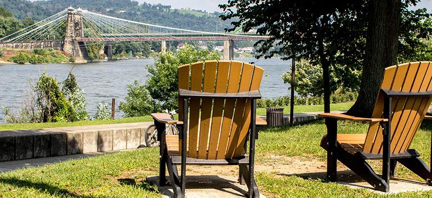
View of Wheeling Suspension Bridge from Heritage Port (Wheeling Convention and Visitors Bureau)
CULTURE
The City of Wheeling is alive with self starters who have an eye for craftsmanship and innovation.
A robust culture is one that recognizes the diverse rituals, practices, values, and aspirations that help a community feel healthy, safe, and create a sense of belonging.
What we heard: Wheeling is seen as a versatile city with significant potential, where it feels like almost anything could succeed. The city’s strong school system is frequently cited, particularly because supporting young people is widely regarded as beneficial for the city’s future.
The city offers many high-quality amenities that meet community needs, including improvements in healthcare through West Virginia University Medicine, a strong school system, and well-maintained homes with beautiful architectural character. Compared to larger cities, Wheeling is statistically, and often perceived as, safer likely due to the friendliness of the community.
There is also great pride in Wheeling’s historic and thriving arts scene, with strong support for local artists. Many believe that promoting the architecture of the historic district and expanding cultural events could further unite the community.
Objective 01
Retain our
emerging local talent with opportunities to stay in the city.
Objective 02
Attract families and professionals to the city.
Objective 03
Strengthen our involvement in the creative production of the arts and our craftsmanship.


View of Wheeling Downtown (Wheeling Convention and Visitors Bureau)
action plan CULTURE
Culture Strategies and Initiatives
Objectives
Retain our emerging local talent with opportunities to stay in the city.
Create career and personal development opportunities to keep local graduates and young professionals in the city. Encourage collaboration between industries, startups, and educational institutions to support job growth. Offer attractive live-work environments to retain talent.
Indicators
Increase in population aged 18 to 24
Number of young people increasing (18-24)
Attract professionals and families into the city.
Develop family-friendly neighborhoods and vibrant communities with access to quality schools and healthcare. Provide diverse housing options and employment opportunities to attract professionals and families. Create marketing campaigns that highlight the city’s strong work-life balance.
Increase in population aged 24 to 48
Number of young adults increasing (25-48)
Initiatives
Youth Leadership Programs
Assist schools and nonprofits to give young people opportunities to take on leadership roles within their communities.
Apprenticeship Programs
Facilitate partnerships between businesses and educational institutions to provide practical skillbuilding and industry credentials.
Early Childcare Programs
Foster public-private-nonprofit partnerships to enhance child care choices.
Smart City Initiatives
Create a task force to evaluate and collaborate with regional technology programs and institutions to implement right-sized smart cities technology.
Industry Connect Series
Coordinate and host events with business support programs to create an engaging entrepreneurial environment.
Neighborhood Recreation Centers
Explore the concept of neighborhood recreation centers with interested organizations.
Strengthen our involvement in the creative production of the arts and our craftsmanship.
Support local artists and craftspeople by providing resources, grants, and platforms for showcasing their work. Encourage community engagement with the arts through public events, installations, and cultural programs. Foster a vibrant creative economy that celebrates diversity and innovation.
Increase in number of jobs for Artists
Number of jobs in arts
Public Arts and Performing Arts Trust Fund
Secure and allocate art-related grant funds and support with technical assistance.
Arts and Culture District Development
Create an arts and cultural district with district planning and the implementation of financial tools.
Neighborhood Arts Programming
Collaborate with local organizations and private groups to help neighborhoods apply for grants and plan their projects.
initiatives CULTURE
Youth Leadership Programs
Historically, many young people left Wheeling in the 1990s, believing they wouldn’t return. To reverse this trend and ensure that youth have a stake in the city’s future, it is crucial to engage them now. Youth leadership programs create a pipeline of future leaders who are invested in Wheeling’s long-term success. Wheeling can build on programs like Men of Change and those run by Wheeling’s Parks and Recreation to create a pipeline. Other programs like the Northern Panhandle Workforce Development Board’s Youth Job Training provide critical skills for the future.
Wheeling can increase opportunities for communication and collaboration, ensuring all community members, especially youth, feel included in discussions about Wheeling’s progress. Creating spaces for dialogue—such as youth councils or youth summits—will ensure that diverse perspectives are heard and incorporated into city planning and development. The National League of Cities (NLC) offers valuable resources for engaging youth in local government, advocating for treating youth as partners, preparing them for leadership roles, and respecting their voices. Wheeling can leverage these resources to establish a structured and effective youth leadership program.
Wheeling can assist schools and nonprofits to give young people opportunities to take on leadership roles within their communities, contributing to long-term civic engagement and empowerment.
Apprenticeship Programs
Wheeling faces workforce gaps, partly due to the historical decline of its industrial sector and the out-migration of young people seeking opportunities elsewhere. Apprenticeships offer a valuable solution, especially in trades like welding, HVAC, and plumbing, providing career on-ramps that help retain local talent by offering well-paying, local job opportunities. Institutions like West Virginia Northern Community College, West Liberty University, and Wheeling University offer outreach and programs can be coordinated to engage the community with internships, service days, and partnerships. An apprenticeship program would further strengthen these ties, allowing both local students and adults to develop practical skills and gain real-world experience without leaving Wheeling.
Apprenticeships offer a combination of practical work experience and paid training, making education more accessible by removing cost barriers. This “earn while you learn” model enables individuals to gain industry credentials while supporting themselves financially. The existing West Virginia Laborers’ Training Trust Fund already offers a Construction Craft Laborers Apprenticeship Program with connections to Wheeling. This framework can be expanded to create a broader apprenticeship program, offering residents opportunities for high-demand jobs in various industries.
Wheeling can facilitate partnerships between businesses and educational institutions to build programs that provide practical skill-building and industry credentials, all while giving participants real job experience.
Early Childcare Programs
Many families, especially those transferring from military and medical fields, struggle to find suitable childcare options. Without adequate support, these families may choose to relocate, which could result in a loss of talent and diversity in the community. An early childcare program would provide essential support for families, making Wheeling a more attractive place to live and work. Early childhood education is often mistakenly viewed as mere babysitting rather than a vital component of a child’s educational journey. By promoting early childcare as an integral part of education, Wheeling can shift this perception and emphasize the importance of early learning in a child’s development.
Early education is crucial for increasing community capacity and cultivating a skilled workforce. By investing in early childcare, Wheeling can lay a strong educational foundation that promotes lifelong learning and adaptability in its future residents. The City of Wheeling can invest time in collaborating with workgroups (which include child care providers and parents as well as the WVAYC) and advocate for state policies that will increase child care capacity. Wheeling has existing childcare facilities, such as Sikora Montessori, New Bridge Academy for Kids, King’s Daughters Childcare Center, and others, which can be integrated into a comprehensive early childcare program. The lack of accessible early childcare can have long-term negative consequences, including increased reliance on the foster care system.
Wheeling can foster public-private-nonprofit partnerships to enhance these offerings. By investing in early childcare, Wheeling can help mitigate these risks and provide a supportive environment for children and families.
initiatives CULTURE
Smart City Initiatives
Increasing internet access and bandwidth will help Wheeling become a “smarter” city by enabling more efficient urban systems. The internet plays a growing role in monitoring and managing key city functions—from public safety to stormwater management—creating more synchronized systems that contribute to a higher quality of life for all residents. For instance, synchronized traffic lights are a practical application of “Internet of Things” (IoT) technology, helping to reduce traffic congestion and improve flow. Additionally, air and noise pollution monitors provide real-time data on environmental conditions, helping to safeguard public health.
Cities have also begun using internet-enabled systems for safety, such as sensors and devices that monitor infrastructure, detect potential hazards, and ensure timely maintenance. Wheeling can build on these trends, in ways that make the most sense for the size and resources, and can integrate advanced technologies and data with existing city infrastructure. Wheeling can create a task force to evaluate and collaborate with regional technology programs and institutions to scan for possible synergies in infrastructure improvements.
Industry Connect Series
Wheeling needs to continue support for young entrepreneurs and emerging business leaders. An “Industry Connect Series”, building on existing programs like Wheeling Heritage’s Show of Hands and RED’s CO.STARTERS, would provide essential resources, networking opportunities, and mentorship for those looking to start and grow businesses. This series would create a platform to connect young people, including students and immigrants, with local industries and job opportunities, helping Wheeling attract and retain the next generation of talent.
Through partnerships with local institutions, the series would engage students and young professionals, connecting them with industries that are actively hiring and providing insight into various career paths, including the trades and entrepreneurship. This approach ensures young people are better equipped for the workforce and more likely to remain in Wheeling. Wheeling can coordinate with business support programs to host events that create an engaging entrepreneurial environment that enhances career prospects and business development.
Neighborhood Recreation Centers
The community has expressed a significant need for community and senior centers throughout Wheeling, particularly in historically underrepresented neighborhoods. A neighborhood recreation center would help address this gap, providing accessible spaces for socialization, recreation, and communitybuilding activities.
Institutions like Catholic Charities Neighborhood Center, Clay School, and YMCA have already demonstrated the value of such facilities. A dedicated center could build on these efforts, offering spaces for physical activity, educational programs, and social engagement. These centers could also connect residents to services such as healthcare, government assistance, and parental support, thereby improving community well-being. Collaborative groups like the Family Resource Network meetings offer social services that would support the city’s efforts to increase access to quality programming.
Wheeling can explore the concept of neighborhood recreation centers with interested organizations during neighborhood planning efforts.
Public Art and Performing Arts Fund
Wheeling has a diverse cultural history, and a dedicated arts fund would help preserve and celebrate this heritage through art while encouraging new forms of artistic expression that reflect the evolving community. A fund or endowment would create more opportunities for collaboration, inclusivity, and engagement through public and performing arts programs.
Wheeling Heritage, Oglebay Institute Stifel Center, and Wheeling Arts and Cultural Commission operate several programs that support local artists and cultural initiatives, such as partnership grants for arts and community development. These grants fund a variety of projects, including public art installations, festivals, and artist support, helping to maintain and grow the city’s vibrant cultural scene. A public art trail has been developed, and additional art programming helps connect local artists with the broader community.
In other cities, arts funds also provide access to technical assistance. For example, Shiftworks, a nonprofit in Pittsburgh, connects artists to public art opportunities and bridges the gap between ideas and implementation by offering technical assistance.
Wheeling can collaborate with organizations to secure and allocate art-related grant funds and provide technical assistance to enhance public art installations and performance spaces.
initiatives CULTURE
Arts and Culture District Development
Catalytic projects like the development of Heritage Port, Capitol Theatre, and Centre Market have played a significant role in shaping downtown Wheeling’s cultural and economic landscape. Looking forward, the focus is on further increasing urban density, promoting waterfront development, and supporting creative entrepreneurs and small businesses to enhance vibrancy in the downtown area. An arts and cultural district plan ensures that the arts are integrated into community and economic development.
Arts and cultural districts have the potential to become destinations, similar to Pittsburgh’s Cultural District. The Pittsburgh Cultural Trust manages multiple venues, from concert halls to movie theaters, and oversees programming to establish the district as a regional destination. Smaller districts can leverage local offerings such as live music venues, maker spaces, and galleries. Areas like Water Street and the success of Waterfront Hall could evolve into cultural hubs, similar to Beale Street in Memphis, positioning Wheeling as a regional entertainment destination. Wheeling can create an arts and cultural district through district planning and the implementation of financial tools that incentivize and support development.
Neighborhood Arts Programming
Neighborhood arts programming can be a powerful tool for strengthening community ties and showcasing the unique character of each area in Wheeling. By offering small grants to neighborhoods for arts programming—including events, performances, and public art installations—Wheeling can empower residents to create cultural experiences that reflect their neighborhood’s identity. These projects could include murals, street art, temporary installations, or arts-focused festivals that bring residents together.
The outcomes of these neighborhood-led arts initiatives should be captured and promoted as part of what makes Wheeling a vibrant and creative city. Showcasing these efforts can drive tourism and encourage long-term investment in the arts, while demonstrating that the city values community-driven creative expression.
To support this initiative, Wheeling can collaborate with local organizations and private groups to help neighborhoods apply for grants and plan their projects.
DEVELOPMENT
The City of Wheeling is a growing destination that supports local and regional activity.
Development changes the character of the land to be more reflective of the evolving needs of residents and businesses.
What we heard: The development downtown and along the riverfront is well-received by the community, aligning with the priority of renovating historic buildings in need of repair. While progress seems slow, it is moving in the right direction, and the clear communication of these efforts is appreciated.
The addition of more riverfront events has successfully attracted residents to revitalized areas, and there is growing demand for more opportunities to bring the community together.
With greater interstate cooperation, the city could secure funding for larger economic development initiatives. State funding is also available to support affordable housing development, which remains a top priority for residents. Housing development ideas range from context-sensitive infill and affordable rentals and condos to a year-round shelter for the city’s most vulnerable populations (more in the Housing Section).
Objective
01 Support an evening economy in the downtown historic districts.
Objective 02
Create a clear process for the preservation of underutilized properties. Urban
Objective 03 Integrate campus connectivity to meet broader community needs.


View of Wheeling Downtown (City of Wheeling)
action plan DEVELOPMENT
Development Objectives and Initiatives
Objectives
Support an evening economy in the downtown historic districts.
Serving as the region’s economic center, Wheeling’s downtown historic areas should prioritize businesses and cultural activities that extend into evening hours. By encouraging restaurants, entertainment venues, and shops to stay open later we promote a vibrant nightlife that attract residents and visitors looking to make memories in the city.
Indicators
Increase in Nightlife Business Establishments
The nightlife economy is comprised of five subsectors that typically operate between 6pm and 6am, including food service, bars, arts, venues, and sports and recreation
Initiatives
Public Space Improvements
Plan for public realm improvements and consider programmatic initiatives for public realm activation.
Safety and Accessibility Improvements
Enhance public infrastructure by improving lighting, adding security measures, and creating accessible pathways.
Business Improvement Districts
Facilitate the establishment of designated areas where property owners can collectively invest in district improvements.
Create a clear process for the preservation of underutilized properties.
Develop guidelines and incentives for the adaptive reuse of vacant or underutilized properties. Streamline the approval process for rehabilitation projects to encourage revitalization. Prioritize the preservation of properties that align with long-term city development goals.
Increase in Building Permits
Building permits on vacant/ underutilized parcels
Expand institutional campuses to accommodate broader community needs.
Collaborate with educational and healthcare institutions to plan campus expansions that address community growth. Ensure expanded campuses support access to services like healthcare, education, and job training. Integrate institutional resources into the community to foster stronger connections.
Increase in Building Permits
Building permits/business permits within 1/4 mile of medical and educational land uses
Citywide Zoning and Building Code Updates
Revise regulations to govern land use, building design, and construction standards.
Land Banking
Leverage a land bank to focus on acquiring problematic properties, clearing titles, and preparing sites for redevelopment.
Community Benefits Agreements
Study best practices for Community Benefit Agreements (CBAs).
Urban Redevelopment Projects
Coordinate planning and vision session around the revitalization and transformation of underdeveloped or blighted areas.
Community Access Programs
Facilitate conversations on how events and initiatives can strengthen connections between educational institutions and residents.
Targeted Community Revitalization Program
Collaborate with residents through a neighborhood planning process.
initiatives DEVELOPMENT
Public Space Improvements
The community has emphasized the importance of vibrant public spaces, especially for concerts, recreational activities, and arts programs, which help create a thriving environment for young people. In response, the city’s Department of Parks & Recreation has proposed key investments, including improvements to playgrounds in parks like the Gateway Parks Masterplan on Wheeling Island and a new Playground in South Wheeling.
As a complement to Wheeling’s parks, the city can enhance its vacant lots and public spaces in the central business district and elsewhere by temporarily transforming them into venues for community events. These spaces can host concerts, markets, and festivals until they are developed, attracting visitors and residents and creating momentum for future development as market conditions improve. Wheeling can plan for public realm improvements like pedestrian plazas, outdoor seating, and street art that contribute to a vibrant and engaging atmosphere that benefits both residents and visitors.
Wheeling can also consider programmatic initiatives such as:
Creating a Temporary Use Policy: Establish clear guidelines for how vacant lots and public spaces can be used temporarily for community events, markets, and pop-ups. This policy can outline safety requirements, event durations, and public/private responsibilities. Cities like Detroit and Cleveland have successfully implemented similar policies to activate underutilized spaces.
Partnerships with the Private and Nonprofit Sectors: Engage local businesses, nonprofits, and developers to co-sponsor events or installations, similar to how Helltown Brewing revitalized space in Pittsburgh’s Strip District with a beer garden. Farmers markets or night markets that utilize the Centre Market and Market Plaza are other examples of neighborhood events.
Offering Incentives for Activation: The city could provide grants, subsidies, or fee waivers to community groups or businesses willing to organize events or temporary installations in these vacant spaces. For instance, cities like Cincinnati have used similar approaches with programs like “Pop-Up Cincy”, which provided small grants to activate vacant storefronts and lots.
Streamlining permitting process: Simplify and expedite the process for obtaining permits for temporary events in vacant lots and public spaces. A streamlined system will encourage local entrepreneurs, artists, and community groups to engage with these spaces.
Marketing and Promotion: The city can actively market these spaces for event use by collaborating with local media, tourism boards, and social media influencers to highlight Wheeling as a hub for creative, communitycentered events.
Safety and Accessibility Improvements
The community in Wheeling has expressed concerns about safety in public spaces, such as parks and trails, with a desire to feel more secure from crime and homelessness. At the same time, there is a clear emphasis on compassion and support for vulnerable populations, balancing safety and humanity. Concerns were also raised about public infrastructure—including outdated sidewalks, crosswalks, and inadequate lighting—that impact general safety.
Crime Prevention Through Environmental Design (CPTED) promotes safer neighborhoods through urban design that discourages criminal behavior. Its core principle is that the perceived risk of being caught deters crime more effectively than the severity of punishment. By implementing design elements like “eyes on the street,” areas can feel monitored and secure.
Key CPTED design principles include:
• Increasing pedestrian and bicycle traffic by designing inviting streetscapes.
• Placing windows to overlook sidewalks and parking lots for natural surveillance.
• Adding motion sensor lights to deter activity in poorly lit areas.
• Organizing regular public activities to signal active use of spaces.
Wheeling can enhance public infrastructure by improving lighting, adding security measures, and creating accessible pathways to ensure that public areas are safer and more navigable, especially after dark. This strategy will encourage residents to engage with parks, trails, and public spaces with greater confidence.
initiatives DEVELOPMENT
Business Improvement Districts
While the City of Wheeling does not have an officially designated Business Improvement District (BID)—a municipally created district where local businesses and property owners collectively fund improvements through special assessments—several local organizations provide valuable services and enhancements benefiting the community. A BID typically funds projects like streetscape improvements, marketing, public safety, and events to boost a district’s appeal to customers and investors.
An example of a successful BID in West Virginia is the City Center BID in Charleston, established in 2021. The Charleston BID has played a key role in revitalizing the downtown area, using pooled resources from local businesses to fund infrastructure improvements, pedestrian enhancements, and marketing campaigns. The BID even received a $130,000 Economic Development Administration (EDA) grant to further support economic recovery and growth
Wheeling stakeholders have emphasized the need for similar support in locally-serving commercial districts, specifically requesting funds for capital improvements such as walkability enhancements and commercial building upgrades. BIDs are often initiated by nonprofits or neighborhood advocacy groups and require a density of businesses willing to contribute. In Wheeling, the Regional Economic Development Partnership (RED) or the Elm Grove Business Association (EGBA) could be ideal candidates to lead the creation of a BID, given their deep involvement in economic development.
To address these needs, the City of Wheeling can facilitate the establishment of designated areas where property owners can collectively invest in district improvements. The city can help by providing technical assistance, seed funding or matching grants, by streamlining regulatory processes for public realm improvements, by facilitating publicprivate partnerships, and by advocating for BID adoption by businesses and institutions.
Citywide Zoning and Building Code Updates
The current planning and zoning ordinance was written in 2001 and has been amended several times since then. A strategic approach to revising or rewriting the ordinance following the comprehensive plan visioning and future land use map should include the following recommendations:
• Rewrite the planning and zoning ordinances to align with current and future needs and to increase useability for applicants and staff.
• Encourage more housing options through expanding housing use types and districts where they are permitted, and adjusting dimensional regulations in the zoning ordinance.
• Develop robust mixed use districts that align with the current and future needs of existing residents, businesses, and institutions, and encourage new residents and businesses to move to Wheeling.
• Update permitted uses to align with current needs and incorporate the flexibility to address future uses.
• Establish clear and reasonable environmental regulations around things like hillside development to enable development compatible with Wheeling’s natural features.
The City of Wheeling can revise regulations to govern land use, building design, and construction standards that facilitate growth while maintaining safety and community standards.
initiatives DEVELOPMENT
Land Banking
The city of Wheeling has over 800 parcels identified as vacant, many of which present development challenges such as being brownfields, located on steep slopes, or within floodplains or banking deserts. These areas have traditionally been difficult to redevelop due to complex issues like tangled titles, tax liens, or aging structures. In response, Wheeling has historically acquired such properties to prepare them for future investment and development, providing the city and community more control over how they are utilized.
To manage these properties more effectively, Wheeling could consider establishing a Land Bank, similar to the one in Huntington, WV. Huntington’s Land Reuse Agency, created in 2009, acquires tax-delinquent properties, stabilizes neighborhoods, and returns the properties to productive use. This strategy not only preserves property values but also reduces the burden on local government by addressing blight and making land available for redevelopment. Such a model could help Wheeling address its vacant parcels, particularly in neighborhoods like Wheeling Island, East Wheeling, and South Wheeling, which are in critical need of stabilization.
Wheeling can leverage a land bank to focus on acquiring problematic properties, clearing titles, and preparing sites for redevelopment, ensuring they align with the city’s economic and community goals. This approach would encourage long-term investment, particularly in historically underserved areas.
Community Benefits Agreements
The City of Wheeling can consider establishing Community Benefit Agreements (CBAs) to foster mutually beneficial relationships between the community and large-scale developers at key sites. These agreements can focus on aligning community and developer priorities, such as infrastructure improvements, employment opportunities, and training programs. At a minimum, municipalities can ask developers to create strategies for community collaboration that include addressing potential negative impacts, identifying shared projects, and improving access to jobs and resources.
For example, in Pittsburgh, the Hill District CBA secured over $3 million in community benefits from the redevelopment of the former Civic Arena site, including funding for housing, job training, and business development in the historically underserved neighborhood. As the market grows stronger, Wheeling can facilitate similar negotiations between developers and the community to define benefits such as affordable housing, job training, or public amenities.
Wheeling can study best practices for Community Benefit Agreements (CBAs), learning from other cities that have successfully implemented these agreements, and ensuring the legality of CBA practices in WV. This will equip the city to facilitate productive discussions between developers and the community in future projects.
Community Access Programs
Educational institutions like Wheeling University and West Virginia Northern Community College have expressed interest in conducting outreach to better serve and connect with the community and local nonprofits. This outreach could include offering the use of spaces or creating programs that meet community needs. Residents have voiced a strong desire for more accessible spaces to support small businesses and restaurants, provide childcare, and offer non-degree educational programs.
In response, the City of Wheeling can facilitate conversations on how events and initiatives can strengthen connections between educational institutions and residents, fostering stronger ties between these institutions and the broader community.
initiatives DEVELOPMENT
Targeted Community Revitalization Program Urban Redevelopment Focus Areas
Some areas of Wheeling such as Downtown and East Wheeling have experienced high levels of vacancy and disinvestment that the neighborhood character has been significantly diminished, requiring coordinated redevelopment efforts. In addition, past planning policies and financial incentives shaped cities nationwide resulting in displacement and further disinvestment. Though smaller in scale when compared to larger cities, Wheeling did not escape practices such as redlining and highway construction in low-income neighborhoods, resulting in detrimental effects to all Wheeling residents, with some of the more economically or socially vulnerable being especially impacted.
To ensure future development aligns with community needs and to position projects and planning to take advantage of federal and state funding, the city can lead neighborhood planning processes that integrates development potential with community-driven goals.
Neighborhood plans can integrate already-known development opportunities, such as the WVU Medicine Cancer Center, with lesser-known but equally relevant community priorities. The process of neighborhood planning also galvanizes other partners and organizations essential to an equitable neighborhood transformation.
The areas around Wheeling Island Casino and West Virginia Northern Community College are of particular significance in this regard and could be prioritized for a community-led program to identify improvements that benefit current residents. The community has expressed a desire for more sustainable infill development and there is an interest in developing a vacant lot strategy to transform smaller parcels into community gardens, pocket parks, or short-term cleanup initiatives.
The City of Wheeling can collaborate with residents through a neighborhood planning process to support infrastructure upgrades, housing improvements, and economic development in underserved areas, ensuring that these efforts benefit the existing community.
high priority project
RIVERFRONT DEVELOPMENT
Wheeling can strengthen its river town identity by investing in both sides of the Ohio, creating more cultural, ecological, and recreational opportunities.

CreekSIDE RIVERFRONT
Wheeling’s identity is deeply connected to the Ohio River, yet access to the river is limited. Wheeling can strengthen its river town identity by investing in both sides of the river.
While the city has successfully transformed part of the downtown into an active riverfront at Heritage Port, further development around the park is minimal. The downtown riverfront zoning district encourages river-facing development and mixed-use structures would enlived both the street and waterfront sides of the blocks.
On Wheeling Island, a revitalized casino district can become a regional attraction. This area currently features a naturalized shoreline and a trail with access to the surrounding neighborhood. With adjacent active uses and a hardscaped park, the area could be more robust as a local amenity and regional attraction.
On the west side of Wheeling Island, the back channel riverfront is zoned for smallerscale uses and recreation, such as parks. It serves as a regional draw for passive activities like kayaking, with less water traffic, shallower waters, wildlife presence, and a less eroded shoreline. This area offers more places for fishing and ecologically focused, small-scale recreation.
The Creekside riverfront, designed for local use, includes small access points with varying scales and features like bridges, crossings, and beaches. These areas could be activated with kayak rentals and trail connections. The park and trailhead plan for the former Robrecht railyard can serve as a model for other brownfield sites across the city, which could explore similar funding opportunities through the US DOT and US EPA.
3 2 1 BACKCHANNEL RIVERFRONT
The Creekside riverfront offers small access points suited for local uses, with varying scales of bridges, crossings, and beaches, enhanced by kayak rentals and trail alignment to attract local visitors.

DOWNTOWN RIVERFRONT
The downtown riverfront zoning district promotes river-facing development, including the redevelopment of the casino area as a regional draw, with a naturalized shoreline and a trail providing access to the adjacent neighborhood.

The back channel riverfront is a zoning district that supports smaller uses and recreation, like parks, and serves as a regional draw with its location west of Wheeling Island.
Wheeling Heritage Port (Wheeling Convention and Visitors Bureau)
Vacant Waterfront Parcels
Waterfront Parcels
Trailways
Priority Corridors
Base Map
Existing Buildings
Neighborhood Assets
City of Wheeling Boundary
Neighborhood Parks
River and Creek Areas
Surrounding Street Centerlines

ECONOMY
The City of Wheeling is an partner for people and industry realizing their full potential.
The economy includes the places of exchange and jobs where we work to create prosperity and improve our wellbeing.
What we heard: Efforts to improve downtown have been well-received, and there is eagerness to see this investment expand to other areas. Recreational amenities like riverfront parks and the Capitol Theatre contribute to vibrant street life and attract both local and regional visitors. The city’s proximity to the interstate offers an economic advantage by connecting Wheeling to larger economic hubs such as Pittsburgh and Washington.
Collaboration between community groups and the city government has been successful in promoting economic growth, and local businesses are encouraged by these efforts. There is a strong desire to attract more diverse and innovative industries in science, technology, research, and manufacturing, which would build on the city’s legacy and offer local career opportunities for young people pursuing advanced degrees. These industries could also provide higher wages for workers at all education levels.
Urban System ProposalEconomy
Walk Access to Employment (High to Low)
Priority Streets
Riverfront Corridors
Institution Buildings
Base Map Layers
Neighborhood Assets
City of Wheeling Boundary
Neighborhood Parks
River and Creek Areas
Existing Roads


View of Wheeling Downtown (City of Wheeling)
action plan ECONOMY
Economy Objectives and Initiatives
Objectives
Attract high-paying jobs with the potential for growth into the region.
Focus on attracting industries that offer competitive wages and growth opportunities. Support workforce training programs to align local talent with high-growth sectors. Offer incentives to businesses that create long-term, high-paying jobs in the region.
Indicators
Increase in Average Monthly Income
Increase in wages; AMI
Attract businesses in key industries.
Target industries vital to the city’s economic future, such as technology, healthcare, and green energy. Create business-friendly policies and infrastructure to attract and retain companies in these sectors. Foster innovation and sustainability as cornerstones of the city’s economic growth.
Support growth among local and entrepreneurial business start-ups.
Cultivate a thriving entrepreneurial ecosystem by providing funding, mentorship, and business development resources. Establish incubators and collaborative spaces that nurture local startups. Create opportunities for entrepreneurs to connect with investors, customers, and the broader business community.
Increase in Number of Industries
Increase in establishments in identified industries
Initiatives
Innovation Districts
Incentivize investment and facilitate partnerships between businesses, research institutions, and startups.
Workforce Development Programs
Work with educational institutions and businesses to provide residents with the skills and training.
Research and Development Support
Provide resources, funding, and infrastructure to support innovation and technological advancement.
Relocation Grants
Facilitate financial incentives to encourage businesses to relocate.
Employment Accessibility Initiatives
Convene and coordinate stakeholder providing necessary transportation and accommodations.
Targeted Industry Recruitment Programs
Partner with organizations to focus on business recruitment and support.
Increase in small businesses
Increase in >10 employee establishments
Extended Business Hours
Facilitate public services that encourage businesses to extend their operations.
Business Incubators and Accelerators
Work with local institutions and businesses to support startups by providing resources such as mentorship, funding, and space.
Revolving Business Loans
Continue to support flexible loans that allow businesses to borrow and repay funds.
initiatives ECONOMY
Innovation Districts
Wheeling serves as a job center in its Workforce Development Region, largely due to WVU Medicine, the state’s largest employer. The city benefits from its strategic location in the Northern Panhandle, a region identified as a hub of healthcare innovation, comparable to UPMC and the Cleveland Clinic. The upcoming cancer center is expected to attract related industries, further strengthening the city’s healthcare sector.
Although manufacturing is not as prominent as in the past, there are still small enclaves of manufacturing companies across the city. However, industries interested in locating in Wheeling face challenges due to limited inventory and high costs, especially for entrepreneurs starting out. For instance, commercial rents in Centre Market can reach $1,500 per month, which many entrepreneurs find unaffordable, especially considering the significant improvements required for available spaces.
Efforts are already underway, with roundtables between local colleges and the commercial/market economic district to explore pathways for both employment and entrepreneurship.
The City of Wheeling can incentivize investment and facilitate partnerships between businesses, research institutions, and startups, fostering technological advancement and driving economic growth.
Workforce Development Programs
Even before COVID-19, many individuals were choosing non-traditional pathways instead of attending college, highlighting the need for alternative programs, certifications, and career paths that support entrepreneurship.
According to Data USA, over 60% of Ohio County’s non-professional programs are in the healthcare field, with the rest covering a mix of education, manufacturing, and information technology.
The community has emphasized the importance of diversifying the range of programs offered, including training opportunities in technology, cybersecurity, as well as fields like cosmetology, construction and plant operations for water and waste water. This diversification is critical to meeting the changing demands of the job market and supporting career growth across a variety of sectors.
Wheeling can work with educational institutions and businesses to provide residents with the skills and training needed to meet current job market demands and foster long-term career growth.
Research and Development Support
The life sciences market, including healthcare, medicine, and human health research, is projected to grow into an $80 billion industry. Wheeling is wellpositioned to leverage its local universities, large patient populations, and planned upgrades to existing hospital facilities to tap into this growth.
The West Virginia University Office of Innovation and Commercialization offers a robust set of resources aimed at fostering innovation, including educational tools, guidance on intellectual property (IP) policy, and access to innovation centers within the school’s network.
Wheeling can provide resources, funding, and infrastructure to support innovation and technological advancement across various industries, helping to position the city as a hub for life sciences and healthcare innovation.
Relocation Grants
Potential business owners describe the City of Wheeling as having a high quality of life, with services that support aging in place and are difficult to find elsewhere in the region. The Regional Economic Development Partnership (RED) provides business relocation services for the Wheeling region, including Ohio, Marshall, and Wetzel Counties, offering corporate consulting and relocation incentives to attract businesses.
Wheeling can facilitate financial incentives to encourage businesses to relocate, with the aim of boosting local economic development and creating jobs.
Employment Accessibility Initiatives
Roughly a third of Wheeling residents can reach 25% or more of the city’s jobs within a 30-minute walk or transit ride. Access to affordable transit is a significant factor for employers considering locating in the city. There have been instances where employees have missed work due to a lack of reliable transportation options, particularly for manufacturing jobs.
To address this, WVU Medicine provides its own shuttle services to supplement regional transit hours, ensuring employees have reliable transportation. Future employers can benefit from coordinated transportation services that ensure access for workers while promoting sustainability.
Wheeling can convene and coordinate stakeholder providing necessary transportation and accommodations, model policies that promote inclusive hiring practices, encourage employers to create more accessible workplaces.
ECONOMY
Targeted Industry Recruitment Programs
There is a strong local talent pool in Wheeling that can support business development in key industries, such as healthcare, business management, and education. While northern West Virginia is known for its extraction industry (as noted by West Virginia Forward), Ohio County has the potential to attract high-income retirees through the development of luxury amenities, such as quality healthcare centers, that cater to their needs. According to the Wheeling Area Economic Outlook (2022-2026), the closure of the Ohio Valley Medical Center has resulted in many patients and staff being absorbed into WVU Medicine. This shift in the healthcare landscape emphasizes the need for economic revitalization strategies that prioritize retaining existing businesses while attracting new ones that align with the community’s needs and culture.
To recruit new businesses, the City of Wheeling can partner with organizations such as the Regional Economic Development (RED) Partnership, the Chamber of Commerce, and the local development district to focus on business recruitment and support
Extended Business Hours
Wheeling should consider investing in extended business hours to enhance its nighttime economy and support its thriving cultural scene. Popular attractions such as Broadway plays, the symphony, and events like The Nutcracker and music festivals provide a solid foundation for entertainment. However, issues related to mobility options like Uber availability and parking challenges, particularly during larger events, need to be addressed to fully capitalize on this potential.
By expanding business hours, the city could offer essential services and refreshments after shows, creating a more vibrant atmosphere and further supporting local businesses. This investment would not only foster economic growth but also strengthen community cohesion and enhance the experience for both residents and visitors.
Wheeling can facilitate public services that encourage businesses to extend their operations beyond traditional working hours to better meet local needs and stimulate economic activity.
Business Incubators and Accelerators
Wheeling can invest in business incubators and accelerators to foster entrepreneurship and support emerging business leaders, particularly
given the absence of a dominant industry in the area. By creating a more business-friendly environment and promoting entrepreneurship and trades as viable career paths, Wheeling can help residents develop competitive, transferable skills. Partnering with local institutions to engage students and offering financial resources to young entrepreneurs will help cultivate a workforce that attracts both talent and companies.
Programs like Wheeling Heritage’s Show of Hands and RED’s CO.STARTERS have been successful in identifying and supporting local talent. The city can expand these efforts by providing spaces for small businesses outside of established areas like Centre Market. Investing in business incubators would create opportunities for a diverse range of businesses—both physical and online—from restaurants and childcare services to research, technology, and healthcare. This would boost economic growth and contribute to a more resilient community.
Wheeling can work with local institutions and businesses to support startups by providing resources such as mentorship, funding, and office space, helping new businesses grow and succeed.
Revolving Business Loans
Access to capital is a top priority for many entrepreneurs and small businesses. In the past, the region has had various avenues to secure loans, supporting everything from start-ups to expanding businesses.
A renewed focus on small investors and local entrepreneurship has also led to the development of Show of Hands, a community-supported crowdfunding event hosted by Wheeling Heritage. This initiative helps entrepreneurs open or expand their businesses in the city by securing critical financial support.
The Economic Development Revolving Loan Fund (EDRLF) was a Community Development Block Grant (CDBG)-funded program that provided low-interest, gap financing to businesses. Although this program no longer exists, future federal and state funding might allow for the reestablishment of a similar program. Philanthropic funds and local financial institution lending might also fill some of the need.
Wheeling can look for additional opportunities to support flexible loans that allow businesses to borrow and repay funds, providing adaptable capital for ongoing needs and growth.
high priority project
ENTREPRENEURIAL SUPPORT
We empower existing businesses and future innovators with districts that serve as expanded hubs of support services and creative spaces.

POP UP RETAIL TYPOLOGIES
Pop-up or short-term retail provides a lowrisk way to test new ideas, especially in the food service industry. Similar strategies can be applied to existing spaces through the use of temporary storefronts.
Wheeling has made significant progress in supporting small businesses, particularly in the thriving Centre Market district. Centre Market offers a mix of small and large buildings, allowing various types of business owners to participate in the area’s revitalization. The development is currently driven by the redeveloping hospital site. Ongoing attention will be needed to maintain a balanced mix of businesses that cater to the hospital’s needs, the local neighborhood, and the Market’s regional visitors.
Downtown Wheeling, while home to anchor businesses, faces challenges in achieving the same level of success. Business owners report that many commercial spaces are either too large or too small, making it difficult to find the right fit. High rental
costs also discourage smaller businesses and startups from moving in, while the limited availability of updated Class A and Class B commercial spaces further limits opportunities for new businesses.
Other areas in Wheeling, such as East Wheeling and Fulton, are well-suited as mixed-use flex districts that allow for commercial, retail, and residential development. These areas take advantage of Wheeling’s existing building stock and are valued for their affordable, adaptable spaces, enabling companies to test new business models. Continued business assistance, including help in finding suitable spaces, is essential for Wheeling’s ongoing success.


MIXED-USE COMMERCIAL BUILDINGS
Many of Wheeling’s existing buildings are suited for retail on the first floor and commercial or residential above, ensuring activity during most of the day.

INDUSTRIAL BUILDINGS
Wheeling has many older industrial buildings. Long span metal shed-type buildings that can be repurposed for light industry or for other uses. Brick warehouses and buildings are well suited for commercial or residential conversion.
Wheeling Heritage’s Show of Hands (City of Wheeling)
Existing Commercial Buildings
Commercial Cores
Entrepreneurial Areas
Primary Corridors
Base Map
Existing Buildings
Neighborhood Assets
City of Wheeling Boundary
Neighborhood Parks
River and Creek Areas
Surrounding Street Centerlines

HOUSING
The City of Wheeling is building community with walkable, historic, and sustainable neighborhoods.
Housing refers to where people live, including single family homes, duplexes, apartment buildings, and eldercare facilities.
What we heard: The city’s historic housing stock, known for its strong architectural character, is being restored with the help of partners like Wheeling Heritage and Friends of Wheeling. However, many citizens remain unaware of these efforts and would benefit from better communication and technical assistance.
There is also a perception that the city needs additional capacity to address key issues such as environmental stewardship, safety, residential blight, and project management. Citizens are eager to be involved in budgeting exercises and in decisions on how resources are allocated.
Despite these challenges, Wheeling has successful loan programs, such as the FirstTime Homebuyers Program and the Laughlin Loan Program. Objective 01 Increase housing choices for firsttime home buyers.
Objective 02 Provide quality homes that welcome new residents and remain affordable for the city’s current residents.
Objective 03 Preserve the historic character of the city’s existing housing stock.
Urban System ProposalHousing
Density of Intersections
Housing Built before 1938
Historic District
Base Map Layers
Neighborhood Assets
City of Wheeling Boundary
Neighborhood Parks River and Creek Areas
Existing Roads


View of Wheeling Downtown (City of Wheeling)
action plan HOUSING
Housing Objectives and Initiatives
Objectives
Increase housing choices for first-time home buyers.
Increase the availability of affordable housing options specifically designed for first-time buyers. Offer financial assistance programs such as down payment support or favorable loans. Promote homeownership as a key step toward economic stability and community engagement.
Indicators
Increase in Number of Homeowners
Increase number of non-corporate owners with addresses within city limits
Provide quality homes that welcome new residents and remain affordable for the city’s current residents
Ensure that long-term residents have access to affordable housing as the city evolves. Implement policies that preserve housing affordability with mechanisms such as community land trusts or housing preservation funds. Develop affordable housing units that cater to the needs of working families and consider financial tools such as tax abatements for affordable housing developments.
Preserve the historic character of the city’s existing housing stock.
Protect the architectural and cultural heritage of the city’s historic neighborhoods. Encourage restoration and preservation efforts through financial incentives and community education. Ensure new developments are harmonious with the existing historic character.
Stability in Rental Prices
Stable rent increases
Increase in Residential permits for Historic Districts
Residential permits in historic areas (not new construction)
Initiatives
Affordable Housing Trust Funds
Develop a trust fund dedicated to financing affordable housing projects.
Community Land Trusts
Support the development of a community land trust.
Homeownership Assistance Programs
Create an “onramp” to homeownership by offering credit. Support first-time homebuyers by providing technical assistance, grants, or low-interest loans to help with down payments and closing costs counseling.
Home Repair and Rehabilitation Programs
Create or support programs to assist homeowners with critical repairs and improvements.
Adaptive Reuse Projects
Develop and use adaptive reuse financial tools and programs.
Historic Preservation Programs
Create a city-specific revolving loan fund for historic homeowners.
Affordable Housing Development Incentives
Review or develop tax credits, grants, or subsidies to incentivize developers to build or rehabilitate properties with a portion reserved for affordable housing units.
Tenant Protection Laws
Explore adopting tenant protections similar to other cities.
Missing Middle Development
Support the development of missing middle housing with zoning updates and tax abatements and incentives.
initiatives HOUSING
Develop an Affordable Housing Trust Fund
As federal funding for affordable housing has decreased, housing trust funds (HTFs) and affordable housing funds (AHFs) have become essential tools for redirecting funding to critical housing projects. These funds can take the form of tax credits or direct financing programs that help offset the costs of affordable housing, thereby increasing the overall supply. Cities can contribute revenue to HTFs or AHFs from various sources, including developer impact fees, general funds, inclusionary zoning in-lieu fees, and real estate transfer taxes.
The National Housing Trust Fund, a funding source from the U.S. Department of Housing and Urban Development (HUD), is designed for the production or preservation of affordable housing through activities such as acquisition, new construction, reconstruction, and rehabilitation of nonluxury housing with suitable amenities. HTF funds are typically allocated to developers to create affordable housing and can be used for purposes like demolition, site improvements, relocation assistance, and operating costs. The targeted levels of affordability can be determined by the city.
Pittsburgh has implemented a robust model through its Housing Opportunity Fund (HOF), allocating $10 million annually to support affordable housing development and preservation. The fund uses various tools, such as the Rental Gap Program, to help developers cover the cost of building affordable units. Additionally, the HOF supports homeownership programs with grants for down payments, closing costs, and home repairs.
This model not only ensures consistent funding from local sources like developer fees and realty transfer taxes but also provides long-term housing stability for low- and moderate-income families. Pittsburgh’s approach offers a valuable framework for cities like Wheeling as they look to implement housing trust funds and similar initiatives.
The City of Wheeling can develop its own trust fund dedicated to financing affordable housing projects, including those aimed at increasing homeownership opportunities. This initiative will help bridge funding gaps, enhance housing availability, and support long-term affordability.
POTENTIAL RESOURCES
SHPO Grants - State Development Grant Program, Survey and Planning Grants
Endangered Historic Properties Fund
National Housing Trust Fund
POTENTIAL PARTNERS
WV Department of Arts, Culture, & History
US Department of Housing and Urban Development
Establish a Community Land Trust
Permanently affordable housing ensures long-term affordability by voluntarily restricting the property appreciation and prevent homes from transitioning to market rates. One effective tool to achieve this is through a community land trust (CLT). In a CLT model, the land trust owns the land, while individuals or families purchase the homes built on that land. By keeping the land under trust ownership and limiting the appreciation of the homes, CLTs help maintain affordability, even in areas where property values are rising rapidly.
CLTs are especially valuable in communities experiencing gentrification or increasing housing demand, as they prevent the rapid conversion of affordable housing to market-rate units. By maintaining a permanent commitment to affordability, CLTs provide long-term housing stability for lower- and middleincome households.
Wheeling can support the development of a community land trust as a strategy to maintain affordability as property values rise. By owning and managing land, the community land trust can allow Wheeling residents to purchase homes at lower costs, ensuring that affordability remains a central focus even as property values increase. This model can be critical in protecting affordable housing stock in growing or changing neighborhoods.
Expand Homeownership Assistance Programs
Wheeling currently manages a successful homeownership program and can continue to partner with nonprofits and banks to expand the program. One area of need cited by the community is to create an “onramp” to homeownership by offering credit counseling for those with poor credit scores.
Wheeling can expand support for first-time homebuyers by providing technical assistance, grants, or low-interest loans to help with down payments and closing costs. These measures are designed to make homeownership more attainable for individuals who might otherwise be unable to meet the upfront financial requirements. By implementing these strategies, Wheeling can expand its homeownership base while promoting financial stability within the community.
initiatives HOUSING
Home Repair and Rehabilitation Programs
Wheeling’s housing stock is aging, with many homes having experienced repeated flooding and deferred maintenance over the years. Homeowners often face challenges in securing funds for repairs, knowing how to properly renovate their homes, or finding reliable contractors, architects, and other professionals to do the work. To address these issues, the city can partner with local nonprofits to connect residents with these essential services, while creating a citywide campaign that encourages homeowners to take action on their properties.
This program can include access to additional funding sources, such as Community Development Block Grant (CDBG) funds, philanthropic support, or a forgivable/revolving loan fund, where homeowners can borrow money for repairs and repay it upon the sale of the property. These financial tools can empower homeowners to make necessary improvements while keeping costs manageable.
A successful example of a home repair program is Project Shine in Huntington, WV. Administered by the city of Huntington, the initiative offers free assistance for minor exterior repairs and accessibility upgrades, helping homeowners comply with city codes. The program, which has completed 75 repairs, focuses on improvements like siding, gutters, windows, and safety features such as wheelchair ramps and security lighting. Driven by local and national volunteers, Project Shine partners with community groups to improve housing conditions and engage residents in hands-on work.
Wheeling can create or support programs to assist homeowners with critical repairs and improvements, ensuring homes remain safe and livable. These efforts will also help maintain long-term affordability, as well-maintained housing is less likely to experience significant price increases that could push out long-term residents.
Adaptive Reuse Projects
Wheeling has made significant progress in incorporating mixed-use development in the heart of downtown while preserving its historic character. Wheeling Heritage’s offices exemplify what public-private partnerships can achieve by reimagining historic assets for modern uses. Additionally, the West Virginia Department of Economic Development’s (WVDED) Office of Sites and Buildings serves as a resource for industrial and office properties available for sale across the city. Redeveloping industrial buildings and sites can anchor neighborhoods and transform them into desirable, walkable communities that would appeal to young professionals, older adults, and can incorporate afforadability measure. Residents and stakeholders have expressed a desire for diverse residential and commercial options and adaptive reuse is looked upon favorably.
To support Wheeling the conversion of underutilized properties into affordable housing or other beneficial uses, Wheeling could develop and use financial tools and programs. Common financial instruments such as tax-increment financing, opportunity zones, new market tax credits, historic preservation tax credits, community development block grants (CDBG), and revolving loan funds. Wheeling can also consider property tax abatements through programs like Build WV, which offers tax exemptions and credits for residential and commercial development, encouraging investment in revitalization projects
Historic Preservation Programs
Wheeling has a number of architecturally significant structures that contribute to neighborhood character, the cultural heritage, and the experience of the community. Over 35% of all stock was built between 1900 and 1940 close to the river and the highway system. Many of these assets are listed on existing National Register of Historic Places and Wheeling Heritage and other historic architecture advocates have taken an active role in developing new historic districts in the Warwood, North Wheeling and South Wheeling neighborhoods.
initiatives HOUSING
Wheeling is already utilizing several effective historic preservation tools, including grants and tax incentives. Wheeling Heritage offers programs like the Wheeling Historic Revitalization Subgrant Program, which provides funds for restoring historic structures. Additionally, federal and state Historic Rehabilitation Tax Credits offer 20-25% tax credits for the rehabilitation of historic, income-producing properties.
Cincinnati Preservation’s Preservation Loan Fund offers low-interest, short-term loans to owners of historic properties. The fund is designed to help stabilize endangered historic buildings, offering financing options that traditional lenders may not cover. The fund focuses on projects such as structural repairs, façade improvements, and other critical renovations. Additionally, Louisville, KY has a similar revolving loan fund established by the Vital Sites preservation nonprofit. This fund prioritizes historic properties in underrepresented neighborhoods, providing loans up to $75,000 for exterior and structural repairs. The fund helps prevent displacement, stabilize communities, and supports long-term revitalization efforts.
Wheeling can create a city-specific revolving loan fund for historic homeowners to enhance its preservation efforts. This fund would provide low-interest loans for renovations and prioritize areas most in need of revitalization
Affordable Housing Development Incentives
Affordable housing can be either for-sale or rental and can serve different income levels, from very low-income households (30% of Area Median Income, or AMI) to “missing middle” housing, which serves households at or above the AMI. Due to the high costs of construction, it is nearly impossible to build new housing that remains affordable without subsidies such as tax credits or grants.
Wheeling is already utilizing tools to support affordable housing through programs like the BUILD WV District, which offers tax incentives to developers working on housing projects. These incentives include a sales tax exemption for building materials and a 10-year property tax credit to help offset construction costs. Projects must meet specific criteria, such as having at least six residential units or a $3 million investment, to qualify. The City of Wheeling can further review or develop tax credits, grants, or subsidies to incentivize developers to build or rehabilitate properties with a portion reserved for affordable housing units. These incentives will help bridge the gap between construction costs and affordability, ensuring that more housing options are available for a range of income levels.
Tenant Protection Laws
Currently, Wheeling operates under West Virginia’s landlord-tenant laws, which cover basic protections, but the city does not have a specific tenant bill of rights or ban the box legislation. Additional protections could offer greater security against exploitation, especially for vulnerable groups like people of color and formerly incarcerated individuals. By safeguarding these populations, the city can also help prevent homelessness and promote housing stability.
Wheeling could explore adopting tenant protections similar to other cities that have successfully implemented these policies
Missing Middle Typologies and Incomes
Single-family homes make up 86% of the residential parcels in the city of Wheeling, creating a strong culture of homeownership for those who have access. In addition, the top two priorities from the public survey were housing affordability and housing choice, especially for younger and senior populations looking to own homes. Many respondents highlighted the need for more affordable options and are open to creative solutions to meet this demand.
Missing middle has two meanings. The missing middle housing typology— two- to four-family residential units—can play a key role in adding muchneeded rental options, supporting walkable neighborhoods, locally-serving retail, and offering more paths to homeownership. Missing middle is also used to describe when middle income households cannot afford places to live because the costs would burden middle income households (between 80%-120% of area median income (AMI)) where subsidies are unavailable
To address both these gaps in the housing market, Wheeling can support the development of missing middle housing with zoning updates and tax abatements and incentives.
MOBILITY
The City of Wheeling is a regional center that builds connections between people, businesses, and institutions.
Mobility helps people access necessary and desired places and to help them achieve security, independence, health, and community. What we heard: Wheeling residents value their walkable neighborhoods. Streetscape improvements are generally viewed positively, despite construction inconveniences.
Outside downtown, walkability remains important, though some neighborhoods are more walkable than others. Micromobility (scooters) is viewed positively, and bike trails are beloved. Residents want safer onstreet bike routes.
Public transit remains challenging due to low demand and scattered destinations. Many residents desire more accessible, affordable transportation and expanded service hours, especially for transit-dependent individuals.
Regional access is highly valued. The interstate connects Wheeling to major cities across three states, but without a compelling reason for travelers to stop, the corridor remains a missed opportunity. Though close to Pittsburgh International Airport, residents cited a desire for affordable transportation if they do not have access to a car.
Objective 02 Support the safe passage of people who travel without a car.
Objective 01 Maintain the quality of our infrastructure. Objective 03 Improve connections to regional networks and destinations.

Urban System ProposalMobility
Density of Intersections
10 Minute Walkshed
5 minute Walkshed
Proposed transit Stops
OVRTA Stops
Priority Streets
Base Map Layers
Neighborhood Assets
City of Wheeling Boundary
Neighborhood Parks
River and Creek Areas
Existing Roads


Heritage Port, Downtown Wheeling (City of Wheeling)
action plan MOBILITY
Mobility Objectives and Initiatives
Objectives
Maintain the quality of our infrastructure.
Regularly assess and upgrade transportation, utility, and public service infrastructure. Prioritize repairs and modernization to meet the needs of a growing population. Use smart technologies and sustainable practices to extend the life of city assets.
Indicators
Support the safe passage of people who travel without a car.
Expand pedestrian and cycling infrastructure to ensure safe, convenient travel for non-drivers. Implement trafficcalming measures and improve street design to prioritize non-motorist safety. Encourage car-free travel through educational campaigns and incentives.
Decrease in number of people who drive alone
Decrease in percentage of people who drive alone
Initiatives
Wayfinding and Signage
Create a signage plan for visitors and residents.
Increase Multimodal Activity
Implement a Complete Streets policy.
Bridge and Tunnel Maintenance
Continue regular inspection, repair, and updates. Amplify advocacy for the Wheeling Suspension Bridge reuse
Transit Stop Improvements
Plan for transit area upgrades as part of a Complete Streets study.
Public Transit Service Expansion
Support OV/EORTA by helping to improve service.
Safe Routes to School
Develop student programs and accessible pathways to and from schools.
Improve connections to regional networks and destinations.
Strengthen transportation links to neighboring cities and regions, promoting seamless travel and economic collaboration. Invest in regional transit systems and infrastructure to enhance accessibility. Foster partnerships with surrounding municipalities to improve connectivity.
Increase in number of people working in the city
Increase percentage of people who come to the city for work
Waterway Stewardship Program
Investigate the potential for water taxis and the docking of large river boats.
Regional Trail Connection
Implement a trail town strategy for trail facilities and adjacent economic development.
Urban Greenway Development
Explore creating a connected greenway system in the Open Space planning.
initiatives MOBILITY
Wayfinding and Signage
For many residents, it is important that Wheeling is not just a prominent connection to other places but also recognized for its position as a regional center. Downtown has seen significant investment in its streetscape with a fresh take on classic branding and signage. The next step includes extending these solid design principles to aid navigation around key assets across the city, such as the Centre Market, Wheeling University, Wheeling Island, trails and parks, and remote sites like Oglebay.
Wheeling can create a signage plan to give visitors and residents insight into the city. Plan, design, and install signage to ensure effective navigation, highlight landmarks and amenities, align with city branding, ensure accessibility compliance, and integrate into broader urban planning efforts.
Multimodal Mobility with a Complete Streets Ordinance
Wheeling offers a variety of transportation options that utilize its rivers, roads, and trails. The National Road, the city’s most visible and prominent connector, is state-owned and sees an average of around 11,000 vehicles daily. To support a more balanced mix of transportation modes, the city is rethinking how the spaces between buildings are used.
Residents have shared that getting around the city without a car is challenging, especially for the elderly. Improving ease of access is a priority, including sidewalk upgrades, enhancements to bike trails, and improving the reliability of public transportation. Many are excited about recent improvements in commercial areas like Downtown, Center Wheeling and around Wheeling University, and would like to see these improvements extended into surrounding neighborhoods.
Wheeling can develop policies and implement projects that ensure the roadway network is designed to accommodate users of all travel modes, ages, and abilities. Wheeling can implement a Complete Streets policy to ensure streets are designed for everyone—pedestrians, cyclists, transit users, and drivers—making travel safer and more accessible for all residents.
Bridge and Tunnel Maintenance
Due to its relationship with the water, Wheeling’s development heavily relied on its network of bridges and tunnels that enabled navigation and transportation. The Elm Grove Stone Arch Bridge, built in 1817, is the
POTENTIAL RESOURCES
Headstart, Transitional Kindergarten, California State Preschool Program (CSPP), Childcare Vouchers
Congestion Mitigation & Air Quality
Safe Streets for All Community Development Block Grant; Community Change Grant; Land & Water Conservation Fund Conservation Service Corps & Civilian Climate Corps Program
POTENTIAL PARTNERS
Schools and Community Organizations
Army Corps of Engineers
OVRTA
Property owners
BELOMAR county
WVDOT
Other roadway owners, trail owners
USDOT
oldest bridge in the state, while the Fort Henry Bridge, constructed in 1955, is its newest. The Wheeling Suspension Bridge, designed by Charles Ellet Jr. and completed in 1849, is the city’s most iconic. Additionally, the Wheeling Tunnel, opened in 1966, allows Interstate 70 and U.S. Route 250 to move an average of 59,000 vehicles daily.
The community has emphasized that future improvements to this foundational infrastructure should also prioritize pedestrian, trail, and bike enhancements, especially where these upgrades overlap with the heritage trail. The historic Hempfield Railroad Tunnel exemplifies this effort, with city-approved funding allocated to rehabilitate the tunnel for pedestrian use and to ensure future maintenance.
Wheeling will continue regular inspection, repair, and updates, which will also prevent potential hazards, to ensure the continued safety and utility of its infrastructure.
Wheeling should also amplify its advocacy for the reuse of the Wheeling Suspension Bridge for light traffic or, at minimum, foot traffic. The bridge is essential to economic development on Wheeling Island and downtown and is a destination in itself. Recent investment in a visitor’s center will amplify its importance.
The listing of the Wheeling Suspension Bridge on the National Register of Historic Places and its designation as a National Historic Landmark does not automatically require the state of West Virginia to preserve the bridge. However, these designations do encourage preservation efforts and provide access to certain protections and funding opportunities, such as grants for preservation projects.
While there is no direct mandate requiring the state to act on preservation, the designation means that any federal or state-funded projects that could affect the bridge must undergo a review process under the National Historic Preservation Act (NHPA). This act requires federal agencies, or state agencies using federal funds, to consider the impact of their actions on historic properties.
West Virginia may choose to take advantage of grants or tax incentives associated with maintaining and preserving the bridge. However, the state’s involvement in actual preservation efforts would typically depend on local and state priorities, available funding, and potential public-private partnerships aimed at maintaining the historic structure. Thus advocacy is required to influence the state’s actions.
initiatives MOBILITY
Transit Stop Improvements
Wheeling is served by the Ohio Valley Regional Transportation Authority (OVRTA) and the Eastern Ohio Regional Transit Authority (EORTA), which operate seven fixed routes in West Virginia and four fixed routes in Ohio. These routes provide a network of public transit stops that connect key areas of the city and the surrounding Bel-O-Mar region, contributing to Wheeling’s role as a transportation hub
Despite the system’s reach, community members have expressed that some bus stops are difficult to locate due to understated signage, and there is a need for safer walkways and more bus shelters. Improvements in these areas, along with enhanced amenities like shuttle connections, bike racks, and dedicated taxi stands, would encourage more residents to use public transit. Large businesses looking for new locations have also shown interest in areas that are accessible by public transit and walkable. Wheeling can plan for upgrades in transit areas as part of a Complete Streets study. With intentional placement of bus stop improvements and strategic land use changes, OVRTA/EORTA can further open Wheeling to regional economic opportunities. Wheeling can launch a comprehensive program to upgrade transit stops by retrofitting them with new amenities like shelters and micromobility stations, improving accessibility, and installing modern technology. Such upgrades would not only support transit users but also help the city attract more businesses and improve overall connectivity within the region.
Public Transit Service Expansion
The Ohio Valley / Eastern Ohio Regional Transportation Authority (OV/ EORTA) currently operates eleven fixed bus routes, which not only connect Wheeling to the region but also help residents access key local destinations, such as WesBanco Arena and events like the annual Light Up Night. These routes are essential to people without cars, including the regions student popultion, and facilitate movement within the community, fostering greater connectivity and participation in city events.
Currently, bus routes end at 6 PM, and residents have expressed a desire for extended public transportation hours, an annual bus pass that
would address transfers that time out after 30-minutes, and real time bus information. Stakeholders also identified two major areas for improvement: enhancing connections between downtown Wheeling and other parts of the city (like the Elm Grove YMCA) through reliable infrastructure and public transportation, and improving connectivity between Wheeling and larger regional draws to that support recreation and workforce development initiatives.
Wheeling can support OV/EORTA by helping to develop new routes, improve existing services, and upgrade infrastructure to increase transit coverage, frequency, and quality These changes would better serve residents’ needs and create stronger ties between Wheeling and the surrounding region.
Safe Routes to School
According to the National Center for Health Statistics, motor vehicle crashes are the leading cause of death for children and young adults aged 5-24, and the second leading cause of death for toddlers and adults aged 25 and older. Each day, 6,000 young people under the age of 19 (22% of the city’s population) leave their homes to get an education, making it crucial that they can do so safely.
Creating a safe environment for young people is a primary concern for residents, who have expressed a desire for more opportunities to involve them in city spaces and activities. Educational facilities, including daycares, K-12 schools, and colleges, are where young people spend the majority of their time. Streetscape improvements such as crosswalks, lighting, and traffic signals around these institutions are eligible for Safe Routes to School (SRTS) funding, which focuses on improving the safety of school neighborhoods and communities.
Wheeling can develop educational and active programs for students, while
initiatives MOBILITY
also prioritizing safer, more accessible pathways to and from schools to support both student safety and community involvement.
Waterway Commuting
With increased investment along its waterways, the city of Wheeling can foster new connections and build a strong culture centered around the water. To achieve this, it is important to integrate water transportation with land-based systems, enhancing people-centered mobility and making the waterways more accessible.
The community supports public realm investments that increase access to and navigation of both the river and creek. Suggestions include kayak rentals, docking stations, and a ferry along the Ohio River. These amenities would provide more ways for residents and visitors to enjoy the waterways and connect with different parts of the city.
As riverfront destinations develop, Wheeling can investigate the potential for water taxis and work with a vendor for seasonal travel, including the docking of large river boats and overnight paddlewheelers. More marinas would enable boat owners to access city destinations, supporting a network of vibrant spaces that bring people together.
Regional Trail Connections
The city of Wheeling is well-served by the Heritage Trail and is connected to the National Scenic and National Historic Trail System and local trails that link to Pennsylvania’s park system. Recreation tourism has become a significant economic driver for West Virginia, and Wheeling is poised to benefit. The city will be within a two-hour bike ride of the Great American Rail-Trail, which connects Ohio and Pennsylvania’s trail assets via the Veterans Memorial Bridge in Weirton, WV. This growing trail network offers both residents and visitors opportunities for outdoor activities and boosts the region’s appeal for recreational tourism.
Residents support expanding the trail network and improving streetscape connections to the waterfront to make the Heritage Trail more accessible for recreation. Wheeling can collaborate with regional authorities and local organizations to create a connected network of trails that span multiple jurisdictions, providing a transportation system for recreation and other kinds of trips.
Wheeling can implement a trail town strategy for trail facilities and adjacent economic development, as seen in Pennsylvania’s Great Allegheny Passage towns. This approach would focus on enhancing the Heritage Trail by adding trailhead amenities such as rest areas, bike repair stations, and signage. These improvements would support trail users and encourage spending in local businesses. Additionally, the city could partner with neighboring communities to promote the trail network as a regional asset, potentially securing state or federal funding for further development and maintenance.
Urban Greenway Mobility Trails
Wheeling has four evenly distributed centers of activity: Downtown, Warwood, Woodsdale, and Elm Grove. Parks and open spaces are common amenities in each district, making up at least one-third of non-residential land uses. Oglebay Park and Wheeling Park are beloved by residents for their recreational and natural offerings, and there is significant interest in improving accessibility to park amenities across the city.
To further enhance these assets, Wheeling could develop linear parks or trails that connect these centers of activity and tie into flood and resiliency planning. Such greenways, which often follow rivers or railways, would provide additional recreational opportunities while improving the city’s environmental quality and pedestrian connectivity. This approach has been successfully implemented in cities like Chattanooga, TN, with their Riverwalk, which integrates recreational trails along the Tennessee River, linking neighborhoods and providing scenic routes for residents and tourists alike.
Wheeling can explore creating a connected greenway system that links its main activity centers through parks and trails By developing these linear parks, the city could enhance access to existing parks, improve walkability, and boost local tourism. Funding opportunities, such as state or federal grants focused on outdoor recreation and conservation, could support these efforts, alongside partnerships with local organizations and neighboring communities
high priority project
EQUITABLE TRANSIT OPTIONS WITH OVRTA
Multi-modal transportation connects Wheeling residents to jobs, services, and amenities, supporting mobility choice for individuals and city-wide development goals.
The Ohio Valley Regional Transportation Authority (OVRTA) plays a crucial role in connecting thousands of residents to employment centers and cultural districts across two states and three counties. While an option for some, public transit is a lifeline for many of Wheeling’s residents, ensuring mobility and access to essential services. Many Wheeling residents view public transportation as vital for city-wide development, citing weekend and extended service, clearly marked stops, improved walkability, and more direct connections to major destinations as key to enhancing the transit experience.


1
LOCAL BUS STOP
Like many transit agencies, OVRTA has limited resources, making it important to carefully target and strategically implement any system changes. To meet the needs of both residents and visitors, clear priorities for stops and routes must be established to improve usability. Additionally, potential changes in land use should be considered to align with these transit improvements, creating a more integrated and accessible transportation network. Lastly, basic amenties such as bus shelters have been requested by the community.


Local bus stops address the first and last mile challenges faced by commuters. Protected shelters, enhanced lighting, and street trees create a more pleasant and safe environment for walking and biking.


2
COLLECTOR HUBS
Collector hubs are key transfer points. Design them for easy mode transfer with clear signage and comfortable stations. Include last-mile options like bike parking, bike shares, and scooter stands. Ideally, pair these stops with transit-oriented development.

3
INTERMODAL CENTER
Intermodal centers, like the one near Wheeling’s Wesbanco Arena, offer efficient route transfers and are located near major developments. Designed for more transit vehicles and higher passenger volumes, they are ideal for transit-oriented development.
City of Wheeling Public Transit (City of Wheeling)
Regional Stops
Connector Stops
Local Stops
5-Minute Walkshed Area
10-Minute Walkshed Area
Primary Corridors
Secondary Corridors
Base Map
Existing Buildings
Neighborhood Assets
City of Wheeling Boundary
Neighborhood Parks
River and Creek Areas
Surrounding Street Centerlines

RESILIENCE
The City of Wheeling is prepared for any challenge through reliable networks of support and infrastructure.
Resilience helps communities adapt and transform in the face of those challenges, helping them to prepare for both the expected and the unexpected.
What we heard: The community expressed a strong desire to be better prepared for environmental events like flooding, landslides, and intense storms. Streetscape improvements aimed at flood prevention are seen as a positive step, but residents want to see these efforts expanded. Such climate events put both current and future development at risk and raise major safety concerns. Many residents also called for stricter regulations on building in landslideprone areas.
Additionally, the community emphasized the importance of preserving outdoor recreational assets, which they consider one of the city’s greatest amenities. They want better access to green spaces, believing it would enhance Wheeling’s appeal to a new generation of residents. This includes more education on planting and tree maintenance for carbon sequestration.
Urban System Proposal-
Flood Affected Zone
Steep Affected Zone
Institution Buildings
Priority Streets
Base Map Layers
Neighborhood Assets
City of Wheeling Boundary
Neighborhood Parks
River and Creek Areas
Existing Roads


action plan RESILIENCE
Resilience Objectives and Initiatives
Improve the health of our environmental assets.
Promote sustainability by protecting natural resources and enhancing green spaces. Invest in conservation initiatives that reduce pollution and restore ecosystems. Engage the community in environmental stewardship and education.
Improve access to essential services.
Ensure all residents have equitable access to healthcare, education, and public utilities. Expand service networks in underserved areas and improve infrastructure to support growing demands. Partner with organizations to provide integrated, accessible services.
Increase in the number of flood resilient buildings contructed
Increase in the number of building permits for flood resistant buildings
Increase in number of people near to essential services
Increase in number of people within 1/2 mile of essential services
FEMA Floodplain Mitigation Plan + Design Standards
Update CRS Program, create a Stormwater Management Plan
Landslide Mitigation
Create a Landslide Mitigation Plan
Brownfield Remediation
Create a Brownfield Redevelopment Task Force
Satellite Grocery Stores
Support strategically located retail outlets and food access programs
Community Health Clinics
Identify vulnerable neighborhoods and support community health clinics
Digital Inclusion Programs
Provide public wi-fi and inventory crisis communications protocols
Augment access to quality parks and recreational amenities.
Expand and enhance parks and recreational facilities to promote active, healthy lifestyles. Ensure these spaces are safe, accessible, and inclusive for all community members. Create programming that encourages greater community engagement with public spaces.
Increase in the population density near major parks
Increase in number of people within 1/2 mile of parks
Parks and Open Space Master Plan
Develop an open space masterplan to include riverfronts, resilience landscapes, and park expansion
Riverfront Connections
Include a riverfront chapter in an open space masterplan and work with property owners to create continuous and high quality access.
Greenspace Initiatives
Implement policies that integrate parks into urban planning
View of Wheeling Downtown (City of Wheeling)
initiatives RESILIENCE
FEMA Floodplain Mitigation Plan + Design Standards
The city of Wheeling was established at the confluence of the Ohio River and Wheeling Creek, where the land was easier to build on and could connect to other communities through regional trade along the waterways. As a result, many of the city’s most historically and architecturally significant buildings have struggled to withstand the damaging effects of increased flooding events. While the creation of the National Flood Insurance Program (NFIP) has provided access to millions of property owners who would otherwise be unable to maintain their properties after a flood, rising insurance premiums have made ownership increasingly costprohibitive.
The West Virginia State National Flood Insurance Program (NFIP) Coordinator’s Office, FEMA, and the West Virginia Technical Center developed the statewide WV Flood Tool to quickly determine whether a property is within a flood zone. This has been an invaluable resource for Wheeling and the entire state. Wheeling can update the WV Flood Tool to include elevation data, building flood loss estimates, and identifying statebased credits within the CRS Program to help lower insurance rates.
Wheeling can create a holistic stormwater management plan that integrates public realm improvements and floodplain design standards to reduce risk and improve flooding outcomes. Potential strategies might include:
• Managed retreat in some areas, where flood-prone and FEMAdesignated properties are aggregated to create greenways.
• Design standards that expedite the production of flood-compliant and affordable construction.
• New construction can be floodproofed with raised development, but the impact of these buildings on neighborhood design should be studied.
• Pre-approved infill housing plans to encourage the construction of safe, affordable housing in existing neighborhoods.
• Programs and funding for retrofitting existing buildings to ensure they remain in service and reduce neighborhood blight.
• Green stormwater infrastructure to help limit runoff by capturing water at the source, using expanded tree coverage, permeable paving, and bioswales.
POTENTIAL RESOURCES
WV HUD
Outdoor Heritage Conservation Fund (OHCF)
POTENTIAL PARTNERS
Fahe - Reimagine Appalachia Link , Primary Care Development Corporation (PCDC)
WVDNR - West Virginia Department of Natural Resources
Landslide Mitigation
Landslides are a common natural hazard in Wheeling, triggered by intense rainfall, mining, and construction activities that destabilize steep slopes, causing damage to buildings, roads, utility disruptions, and potential injuries.
Wheeling’s flat lands were shaped by an ancient riverbed carved by the Ohio River. One key feature of this landscape is the abrupt changes in topography, or hillsides, which heavily influence the city’s development. The limited availability of flat, developable land has led to neighborhoods being built close to these hillsides, increasing the risk to property and safety. Certain routes, such as those in Warwood, are particularly vulnerable to landslides, which can isolate communities when roads are closed.
Stakeholders have expressed concerns about naturally occurring affordable homes built near the hillsides. According to the FEMA National Risk Index, Ohio County has a relatively high risk of landslides and an above-average expected annual loss due to damages. The 2023 State of West Virginia Hazard Mitigation Plan identified 599 acres of land in Ohio County as part of the high-susceptibility Landslide Hazard Area.
Wheeling can create a landslide mitigation plan that identifies high-risk areas and recommends zoning and building code regulations and physical infrastructure to reduce the risk and minimize damage Consider pairing this with floodplain planning for an integrated approach to greenways and open space management.
Brownfield Remediation
Wheeling’s legacy as a manufacturing center and connector has resulted in hundreds of acres of brownfields, or property that may have harmful pollutants. Belomar Regional Council received a grant to assess 26 sites for environmental hazards, including the Wheeling Pittsburgh Steel Building, the former Ohio Valley Medical Center, and the Grow Ohio Valley Food Enterprise Center in Wheeling. The assessments will prescribe what is necessary to allow the sites to be developed.
Wheeling can work with the Task Force to secure funding for remediation efforts and assist with cleanup projects in compliance with environmental regulations for economic growth.
initiatives RESILIENCE
Satellite Grocery Stores
According to the U.S. Department of Agriculture’s Food Access Research Atlas, many communities along the Ohio River face both physical and economic barriers to accessing healthy food, increasing their vulnerability to health issues such as obesity and diabetes. These areas, known as food deserts, are designated census tracts where at least 20% of the population is below the poverty line, or where the median household income is less than 80% ($46,516) of the Wheeling, WV-OH Metro Area median ($56,691). Additionally, residents in these areas live at least a halfmile from the nearest supermarket and are likely to lack access to reliable transportation, further limiting their access to healthy food options. Many places in Wheeling likely qualify as food deserts, including Downtown, East Wheeling, and South Wheeling. To address this issue, Grow Ohio Valley constructed the Public Market in 2019, a full-service grocery store in downtown Wheeling that also features locally grown meat and produce. In addition, the Ohio County Food Security Team was founded in 2020 by a collaboration of local experts, and organizations working to improve food access for County residents.
Wheeling can support the local supply chain by continue to assist in increasing food access in small retail outlets. The city can help enhance the effectiveness and accessibility of smaller, strategically located retail outlets, ensuring they provide groceries and fresh produce to underserved neighborhoods, as recommended in the Wheeling’s LocalFoods,Local Places Action Plan. Other recommendations from the Local Foods report align with mobility and economic development sections of this plan.
Community Health Clinics
Wheeling is well-served by one of the most prominent medical facilities in the state, WVU Medicine- Wheeling Hospital, and has many many healthcare facilities in Downtown Wheeling and Woodsdale-Edgewood, making it a medical hub for the Northern Panhandle. Although the city is renowned for its research and comprehensive medical care, many residents report that access to primary care facilities is difficult.
Wheeling can identify neighborhoods or populations where access is lacking and support community health clinics that offer affordable or free medical, dental, and mental health services.
Digital Inclusion Programs
Ohio County has nearly 19,000 Broadband Serviceable Locations, 93% of which are adequately served with sufficient internet speeds. In 2023, the West Virginia Department of Economic Development, Office of Broadband (WVDED), completed the WV Digital Equity Plan to assess broadband needs and develop programs for digital inclusion across the state. The report highlighted key populations in need of broadband support, including lower-income families, individuals with disabilities, people over 60, and formerly incarcerated individuals.
Wheeling can provide public Wi-Fi and support computer labs and digital literacy training to ensure equitable access to online services and information, helping to bridge the digital divide. The city can also inventory its crisis communications protocols to ensure that everyone can be reached.
Parks and Open Space Master Plan
Wheeling boasts over 2,000 acres of open space, including Wheeling Park, Heritage Port, Oglebay Park, and Gateway Park. Recent improvements to Oglebay and Heritage Port have increased the prominence and public enthusiasm for these spaces. The parks system is highly regarded by both residents and visitors, with events like Oglebayfest and the Festival of Lights attracting thousands to the city in what is often seen as a homecoming.
Wheeling can develop an open space plan that inventories and explains the parks system, improves resiliency of the parks, and identifies programs or projects that would be eligible for infrastructure funding or other sources beyond the city’s budget. The plan would incorporate parks, greenways, and other types of open space to further enhance its park systems. The comprehensive master plan would outline long-term goals for open space development, improvement, and maintenance, increasing both accessibility and quality. Plans should include contingency planning for climate related issues, include renewable energy generation for increased resiliency in emergencies, and should explore the value of urban forests as carbon offsets.
initiatives RESILIENCE
Riverfront Connections
Water is a prominent feature in Wheeling, with miles of land adjacent to Wheeling Creek and the Ohio River. Some communities feel this connection more strongly than others, particularly where well-developed segments of the Heritage Trail and public access to riverfront parks exist. Coordinating public realm improvements that connect existing activity centers to the river enhances both accessibility and the visibility of these areas.
Recently, the city of Wheeling was awarded a $1.7 million state grant to develop pedestrian and bicycle walkways and trails in Robrecht Riverfront Park, where Wheeling Creek meets the Ohio River. Wheeling can continue revitalizing and transforming areas along the river by supporting the development of new public spaces and infrastructure to boost local economic activity and improve community access to the waterfront. Local advocacy and community partners would greatly extend the city’s capacity to create access.
Wheeling can include a riverfront chapter in its open space masterplan and work with property owners to create continuous and high quality access. Riverfront access for properties south of Wheeling Creek should be closely examined in the neighborhood plans.
Green Space Initiatives
According to the Trust for Public Land, two-thirds of Wheeling residents live within a 10-minute walk of a park. The city’s parks offer robust amenities; it maintains and operates over 30 public spaces, 22 playgrounds, a community center, nine tennis courts, four pickleball courts, 19 basketball courts, and over 25 ballfields. It has established the largest regional paved trail systems with over 24 miles of trails. The city has recently invested in renovations for 15 of its 22 playgrounds, repaving the trail system, and has updated its operational software and public communications. It is looking to additional investment, including work at the former Clay School.
Wheeling is striving to achieve access for all of its residents. Although the parks are distributed across the city, people shared that they can be difficult to access. To improve access to these assets, improvements to the streetscapes and sidewalks can better connect people to the park assets.
Respondents also identified vacant land and new development areas as opportunities for additional green space. Wheeling can implement policies that integrate parks into urban planning, such as requiring green areas in new developments or converting unused lots into community parks, to further enhance green space access.
Wheeling can increase the percentage of residents within a 10-minute walk of a park by improving safe access routes to the parks and by looking for additional creative open spaces and temporary uses on vacant land.
high priority project
FLOODING AND LANDSLIDE MITIGATION
Many Wheeling residents are directly impacted by climate uncertainties, requiring a proactive plan led by the city and its partners.

OPEN SPACE PRESERVATION
Preserving open spaces can serve as an effective strategy for landslide mitigation by reducing erosion and stabilizing slopes.
Wheeling has experienced numerous severe weather events over the years, putting longterm strain on its infrastructure and assets. Residents are increasingly worried about the rising frequency and intensity of flooding and landslides, which continue to damage historic buildings and aging infrastructure. These challenges drive up maintenance costs and strain the city’s financial resources, threatening the preservation of Wheeling’s architectural heritage.
Although both flooding and landslides are linked to increasingly volatile climate events, they require distinct solutions. Flood mitigation could involve improving stormwater systems, stabilizing riverbanks, and incorporating green infrastructure to absorb rainwater. In contrast, reducing landslide risks may require geological
assessments and reinforcing slopes and drainage systems.
Uncertainty about the future can be managed through scenario planning, which helps imagine different outcomes for climate and development. By addressing the unique challenges of each issue and testing them against possible future scenarios, Wheeling can better preserve its natural and built assets for future generations..
Infrastructure that keeps people safe can also make them healthier and happier, as new parks and open space amenities can serve double duty as flood mitigation and landslide prevention.


STRUCTURED LANDSLIDE MITIGATION
Structured landscape mitigation, such as terracing, retaining walls, and reinforced vegetation, helps stabilize slopes and prevent landslides.

FLOODING MITIGATION
Building-based flood mitigation includes measures like elevating structures, installing flood-resistant materials, and incorporating barriers such as floodwalls and watertight foundations.
Wheeling Island Flooding (City of Wheeling)
FEMA Floodplain Areas
Affected Buildings
Landslide Prone Areas (slope <10%)
Base Map
Existing Buildings
Neighborhood Assets
City of Wheeling Boundary
Neighborhood Parks
River and Creek Areas
Surrounding Street Centerlines

03
Citieshavethecapabilityofproviding somethingforeverybody,onlybecause,and onlywhen,theyarecreatedbyeverybody.
-Jane Jacobs
NEIGHBORHOOD PLANNING
Understanding the places that make us unique.


Wheeling’s neighborhoods are shaped by the hills and valleys of the Ohio River and Wheeling Creek and inspire a strong sense of community pride. Wheeling’s neighborhoods serve as the heart of community identity and action, where grassroots and institutional efforts converge, and where everyone can take part in shaping the future.
In the previous section “City-Wide Systems” we explored urban development opportunities and connections that spanned across neighborhood boundaries. This section presents neighborhood plans that identify where multiple systems interact and where solving one issue addresses many others. It highlights opportunities for development and programs that support each other and suggests how they can be prioritized to pursue and align resources.
Lastly, the neighborhood plans can guide potential changes to the city’s land use and zoning regulations, promoting long-term sustainability, equity, and economic growth.
Wheeling’s Water Communities
Wheeling’s comprehensive plan designates neighborhoods as river communities or creek communities to highlight shared opportunities and challenges. Though each neighborhood has its own identity and history, understanding commonalities helps bring people together around actions and shared benefits. This section outlines some of the common characteristics and makes recommendations for clusters of neighborhoods.
Some of Wheeling’s neighborhoods draw their identity from the Ohio River and the history of water commerce and industry, while others are shaped by the National Road’s historic movement of people and goods westward and the adjacent Wheeling Creek. Wheeling’s blend of waterways, open space, architecture, and infrastructure inform community identity and these systems were the focus of much discussion during the process. The community’s aspirations for their neighborhoods are highlighted in this section.
WHEELING ISLAND
NORTH WHEELING

EAST WHEELING
DOWNTOWN
CENTER WHEELING SOUTH WHEELING
Wheeling Neighborhood Map ()
FULTON GLENWOOD
WOODSDALE EDGEWOOD
OGLEBAY
PLEASANTON OAKMONT
PARKVIEW
ELM GROVE
MARTIN’S FERRY
BRIDGEPORT
BELLAIRE
WARWOOD
LAND USE DESIGNATIONS
Land Use Designations
Source:ConsultantTeam;OhioCountyPublic Library,“HistoricDistrictsofWheeling”
A land use map is a key tool in a city’s comprehensive plan, providing a visual representation of how different areas are currently being used and how they could be used in the future. It shows the distribution of residential, commercial, industrial, and open spaces, as well as public infrastructure like parks and schools. This helps city planners, residents, and stakeholders understand the current landscape and identify areas that may need change or preservation. The land use map is used to guide decisions about zoning, development, and public investments.
Wheeling’s proposed land use map enhances many existing uses by preserving space for industrial enterprises, while adapting to the growing diversity of jobs linked to medical centers and regional educational institutions. The map recommends strategies that build on the city’s cultural assets, such as the expanding recreation and arts activities near the river. It also addresses key environmental concerns, offering solutions to mitigate the impacts of unstable hillsides and flooding, ensuring that development supports both economic growth and environmental sustainability.
Existing conditions help shape future land use designations, including factors like building type, size, character, condition, parcel size, current land uses, and connectivity. Future goals are then mapped onto these conditions to identify what changes are needed to achieve community goals.
(IO)
(HO)

GENERAL DEFINITIONS
MIXED USE LAND USE
Mixed-use development combines residential, commercial, and sometimes industrial elements within a single area, promoting walkability, reducing the need for car travel, and supporting local businesses. It creates vibrant, adaptable spaces that encourage community interaction and economic growth while enhancing convenience and sustainability.
1 Downtown Mixed-Use (DMU): Higher-density zoning typical for central business districts, allowing for taller buildings with a variety of uses, including commercial, residential, and office spaces.
2 Urban Mixed-Use (UMU): A mid-density district that encourages a balanced mix of residential, commercial, and office uses with moderate building heights.
3 Neighborhood Mixed-Use (NMU): A district that supports small-scale commercial and residential uses, often designed for pedestrian-friendly neighborhoods.
4 Village Mixed-Use (VMU): Suitable for smaller, more suburban or rural areas where development integrates residential and local businesses in a lower-density setting.
5 Corridor Mixed-Use (CMU): Focuses on serving local communities with a mix of medium-density housing and commercial spaces.
INDUSTRIAL LAND USE
Industrial zoning designates areas for manufacturing, warehouses, or other production facilities, creating jobs and supporting the local economy. Properly planned industrial zones reduce conflicts with residential or commercial areas while offering necessary spaces for business development and innovation
Industrial Flex (IF): A district that allows for a combination of light industrial, office, and commercial uses, often in buildings designed for flexibility of use and lower-density configurations.
Limited Industrial (LI): This designation is used to restrict industrial uses to less intensive activities, ensuring compatibility with surrounding residential or commercial areas by limiting noise, pollution, and traffic impacts.
RESIDENTIAL LAND USE
Residential use zoning focuses on creating areas for people to live, offering a variety of housing types to meet different needs and income levels. It fosters community growth, attracts families, and ensures that neighborhoods remain well-integrated and accessible to essential services and amenities.
Village Residential (VR): A district that supports a range of housing types including single-family homes, townhomes, and sometimes small apartment buildings, usually with an emphasis on walkability and community character. Generally adjacent to commercial areas.
General Residential (GR): Accommodates a mix of single-family homes, duplexes, and small-scale multi-family housing like townhomes or triplexes.
PUBLIC LAND USE
Public use designations reserve land for government services, parks, schools, and community centers, contributing to the well-being and quality of life for residents. These spaces improve public health, education, and safety, while also providing essential infrastructure that supports the community’s growth and cohesion.
Parks & Recreation (P&R): Designated for public enjoyment and active or passive recreational activities. These areas include parks, sports fields, trails, playgrounds, and community centers, providing open space for outdoor activities, relaxation, and community events. They are designed to promote public health, well-being, and community engagement, often serving as essential spaces for social interaction and environmental education.
Conservation & Open Space (C&O): Preserves natural landscapes, wildlife habitats, and environmentally sensitive areas for ecological protection and public enjoyment. These areas are typically left undeveloped or minimally developed to maintain biodiversity, water quality, and scenic views. Conservation & Open Space zones support sustainable land use practices, wildlife conservation, and outdoor education, while also providing opportunities for passive recreation like hiking, birdwatching, and nature observation.
Public & Institutional (P&I): Reserved for facilities that serve the public good and provide essential community services. This category includes government buildings, schools, libraries, hospitals, and other institutions such as cultural centers or places of worship. Public & Institutional spaces are designed to support the functions of public administration, education, healthcare, and community gathering, often requiring accessibility, safety, and convenience for residents.
SPECIAL DISTRICTS
Special districts are tailored areas with specific regulations to accommodate unique community needs, such as cultural institutions, historic preservation, or business development. By focusing on a distinct goal or service, these districts help preserve local character, protect resources, and foster specialized economic or social development.
Special Planned District: Allows for unique land use and development standards tailored to a specific area. It provides flexibility beyond conventional zoning regulations to accommodate complex, largescale projects or mixed-use developments, often integrating a blend of residential, commercial, and public spaces to achieve specific planning goals and community benefits.
Innovation Overlay: Special zoning designation that encourages the development of hubs for technology, research, and creative industries within a defined area. It promotes mixed-use development, flexibility in land use, and policies that foster collaboration between businesses, universities, and startups, while providing regulatory incentives to support innovation-driven economic growth.
Historic Overlay: Zoning designation applied to areas with significant historical, architectural, or cultural value. It adds specific regulations to preserve the character and integrity of historic buildings and landscapes, while still allowing for development and use changes that are consistent with the district’s historic significance. These regulations may include restrictions on alterations, demolitions, or new construction to ensure compatibility with the area’s heritage.

Mixed Land Use Designations
Source:ConsultantTeam;OhioCountyPublic Library,“HistoricDistrictsofWheeling”
Wheeling Neighborhoods
Mixed Land Use
01 Downtown Mixed Use (1 DMU)
02 Urban Mixed Use (2 UMU)
03 Neighborhood Mixed Use (3 NMU)
04 Village Mixed Use (4 VMU)
05 Corridor Mixed Use (5 CMU)
Residential Land Use Designations
Source:ConsultantTeam;OhioCountyPublic Library,“HistoricDistrictsofWheeling”
Wheeling Neighborhoods
Residential Land Use
Village Residential (VR)
General Residential (GR)

Industrial Land Use
Designations
Source:ConsultantTeam;OhioCountyPublic Library,“HistoricDistrictsofWheeling”
Wheeling Neighborhoods
Industrial Land Use
Industrial Flex (IF)
Limited Industrial (LI)

Public Land Use Designations
Source:ConsultantTeam;OhioCountyPublic Library,“HistoricDistrictsofWheeling”
Wheeling Neighborhoods
Public Land Use
Parks & Recreation (P&R)
Conservation & Open Space (C&O)
Public & Institutional (P&I)
Special Districts

Public Land Use Designations
Source:ConsultantTeam;OhioCountyPublic Library,“HistoricDistrictsofWheeling”
Wheeling Neighborhoods
Special Districts
Special Planned Districts (SPD)
Innovation Overlay (IO)
Historic Overlay (HO)

Suggested Uses (to be confirmed in a zoning code update)
Limited Video Lottery
Single-family dwelling
Two-family dwelling
Multi-family dwelling
Retail
Restaurant/Hospitality
Office
Hotel/Motel
Commercial recreation
Wholesale/Warehousing
Light Industrial
Heavy Industrial
Civic facilities
Special use
Emergency services
Primary/Secondary education
Higher education
Hospitals
Medical Office
Religious
Other Institutional
Transportation
Utilities/Communications
Parks/Recreation
Golf courses
Open Space
Cemeteries
Agriculture
Forestry
Natural/Conservation
WHEELING CREEK COMMUNITIES
Strengthening community ties along Wheeling Creek, with the Creek at the heart.
Communities in Wheeling are closely connected to Wheeling Creek through historical and presentday relationships. Historically, the Creek was not an amenity but a working waterway that supported industry and commerce.
Today, improved water quality and flood management have made the Creek more accessible for outdoor activities such as biking, fishing, and kayaking. While some of the neighborhoods benefit from the natural beauty and recreational opportunities, more evenly distributed walking trails, parks, and green spaces could foster a sense of connectedness and present opportunities for economic development.
The Creek acts as a natural boundary that shapes neighborhood identity and connectivity. Reconnecting communities to the Creek and each other can augment regional economic development and community involvement.
Innovation Mixed-Use District
Fulton Industrial Hub
Civic Mixed-Use District
WheelingU Neighborbood Campus
Retail and Commercial District
Elm Grove Mainstreet Connection

Creek Community
Waterfront Parcels
Priority Streets
Slopes (High to Low)
Trails
Streetscape Improvements
Neighborhoods
Transit Stops
10 Minute Walkshed
Base Map Layers
Neighborhood Assets
City of Wheeling Boundary
Neighborhood Parks
River and Creek Areas
Existing Roads
Known by the natives as the Kanououara River, Wheeling Creek’s watershed is around 67% forested, 27% agricultural, and 5% urban. 1
The Wheeling Creek Trail begins in Elm Grove and runs five miles to connect to the Ohio River Trail at Heritage Port. 2
[1] West Virginia Department of Environmental Protection
[2] Wheeling Heritage


innovation mixed-use district
FULTON INDUSTRIAL HUB
This area preserves the city’s traditional industrial legacy and serves as an employment hub for makers and innovative start ups.

The Fulton neighborhood is often known for its industrial areas near the Creek but also has residential centers to the north and south. Connector streets along the peninsula need better sidewalks, better lighting and general walkability to bring more people to the commercial area.
PRINCIPLES

DEVELOP RETAIL NODES to create identifiable destinations.

IMPROVE THE COMMERCIAL CORRIDOR to strengthen the nodes.
Peninsula Street is a good connector from Fulton to Downtown but needs better sidewalks and streetlights. The truck traffic creates hazardous conditions for pedestrians and the area there does not have a strong sense of destination.

EXTEND THE INDUSTRIAL CONNECTION to create a district beyond the corridor.

ideas and
Landslide Mitigation
The narrow corridors between hillsides and the Creek are vulnerable to frequent flooding and landslides, posing significant risks to residents and infrastructure.
EARLY ACTION Coordination with landowners and local and federal agenciescanensureproblemsare discoveredearlyandmonitoredbefore theybecomemajorissues.
Streetscape Improvement
Pedestrians navigating the area, often feel unsafe due to high-speed truck traffic and visibility issues. The lack of sidewalks and dedicated biking infrastructure further limits safe travel options, making the area less accessible and inviting.
EARLY ACTION Perform a bike-trail masterplantofindandimprovesafe routesandexpandmobilityoptions.
Commercial & Innovation District
This area of the corridor supports many types of local businesses and could be attractive to businesses looking for flex space.
EARLY ACTIONSupportthe establishmentoflocalbusinessgroups andlookforalignmentofservicesor industries.Engagebusinessowners toidentifypossiblefundingfor infrastructureimprovementstocreate asenseofplace.


FEMA recommends protective measure like avoiding structures close to the hillside and installing protective planting to prevent erosion.
Sidewalk improvements, welldesigned intersections, and infrastructure improvements are essential to a successful commerical district and were frequently cited by the community as a need.
Underutilized industrial buildings are ideal for entrepreneurial ventures, job training, and creative uses. Successful examples include Coalfield Development’s Black Diamond building an Pittsburgh’s Construction Junction, a building material reuse center. Similar projects could thrive in Wheeling’s light industrial areas.
IMAGE Wheeling’s prominent hillsides can be an opportunity and a challenge.
IMAGE Rendering of a sharrow bike lane in Charleston, WV’s bike-trail masterplan.
IMAGE The nonprofit Coalfield Development uses the Black Diamond building for business incubation and job training.


View of Wheeling University (Wheeling University)
civic mixed-use district
UNIVERSITY
VILLAGE AT NATIONAL ROAD
Rich with educational assets this area connects multiple commercial centers that could bring together young innovators and enterprises with local residents.

PRINCIPLES WHAT WE HEARD

CONNECT UNIVERSITY STUDENTS TO COMMERCIAL CENTERS to support local businesses and make a robust student experience.
Wheeling University has private access to the Creek that can be a good connection. Woodsdale could be transformed into a green space or park, offering a good vantage point. Regional regulations focused on slopes and soils, and floodproofing for businesses are important. The Greenways and Heritage Trail could serve as a car-free artery connecting Elm Grove to downtown, aligning with an Active Transportation Plan.


STRENGTHEN ROUTE 40 AS A MIXED USE CORRIDOR to create a destination and provide additional amenties.

SUPPORT CREEKSIDE RECREATION to build resiliency and center the Creek in the neighborhood identity.
Proposed Urban Transportation - Wheeling Access Plan

National Road Commercial District
The National Road corridor has clusters of businesses that could be strengthened and better connected.
EARLY ACTIONConsiderrezoning the Route 40 corridor for mixed use development,includinghousing,and pedestrian-accessiblebusinessesto increasechoiceforpeoplewalking anddriving.
Streetscape Improvements
Cars dominate the business areas and residents from surrounding neighborhoods are intimidated to walk to local merchants.
EARLY ACTIONPerformastudyto identifytrafficcalmingtechniques includingbumpouts,sidewalks,and commercialdistrictbrandingcould maketheareasmoreappealingfor differenttypesofusers.
Creekside Greenway
There is great potential for pedestrian and bike infrastructure that is part of a series of parks and open spaces and that occupies risky flood plain properties.
EARLY ACTIONAWheelingCreek masterplanwouldidentifyways thatcurrentpropertyownersand insititutionslikeWheelingUniverisity couldworktogethertocreatea continuousCreekexperience.


Many colleges have a main street that draws students to off-campus activities. By better connecting Wheeling University students to the National Road, the corridor could attract vibrant, student-friendly businesses that complement the region’s broader economic development strategy.
Pedestrian-friendly intersections with safe crossings, lighting, and signage help calm traffic and create a sense of district identity. Adding trees and other amenities makes travel more welcoming, and well-marked bus stops are key to supporting multimodal transit options.
Trail right-of-ways can act as greenway buffers as properties are increasingly exposed to flooding and weather events. Greenway plans allow cities to incrementally integrate vulnerable properties.
IMAGE Main street serving Meadville College in Meadville, PA.
IMAGE Bumpouts and a change in materials help calm traffic.
IMAGE Trailhead sign for Crabtree Creek Greenway in Cary, NC.

retail and commercial district
ELM GROVE
BUSINESS DISTRICT
This commercial corridor is ideal for a traditional walkable retail that leverages the Creek and historic road as a place of connection.

Elm Grove features a mix of small businesses and schools and is home to the largest commercial district outside of Downtown Wheeling. Drivers from I-70 stop to visit the commercial areas in Elm Grove, which serves as a gateway leading to both Downtown Wheeling and Ohio.
PRINCIPLES

CREATE A WHEELING GATEWAY for people going to and from the highway.

STRENGTHEN THE MAIN STREET CORRIDOR to create a local and regional destination.
The business district could open up to Wheeling Creek as an amenity but needs to manage flooding that could get worse in the future. There are no recreation vendors although there are assets like the Wheeling Creek Trail and the confluence of Little Wheeling Creek and Wheeling Creek.

CONNECT TO THE CREEK to enhance commercial areas and celebrate the trailhead.

ideas and inspirations
Creekside Main Street
Elm Grove is a small commercial district on the National Road that features architecturally significant buildings next to Wheeling Creek. Buildings on the west side of the highly visible main street could open to Creek views and highlight the nearby Community Street trailhead.
EARLY ACTION Collaborate with the localbusinessorganizationtosurvey main street businesses and assess buildingconditions.
Gateway Improvements
Peak hour traffic congestion frustrates commuters and impacts the overall quality of life for residents and businesses. On-street parking can feel squeezed during periods of traffic and nearby parking lots are not well marked, futhering the perception of a lack of parking.
EARLY ACTION Examine intersection signaldesignandtimingtoseeif smallchangescanbetteroptimize trafficflowandimprovepedestrian safety.

In addition to commercial on Wheeling Creek, Elm Grove’s commercial district could thrive with main street signage and clearly marked parking. Investigate if there are any zoning or building code impediments to improvements and consider expedited processes to encourage investment.

Gateway markers next to or over roads can celebrate the entry to a district. Two scales are needed in Elm Grove: one scaled to the highway exit welcoming people to Elm Grove and Wheeling and a smaller scaled overhead sign welcoming people to the commercial district.
IMAGE Creekside Restaurant in Brecksville, Ohio.
IMAGE Forest Hills business district gateway.

on Wheeling Creek (Wheeling Convention
action plan Creek COMMUNITY
Creek Community District Plan
Mixed Use Districts Potential Partners
Innovation Mixed-Use District
Fulton Industrial Hub
Civic Mixed-Use District
Wheeling University
Neighborbood Campus
BelOMar
CityCouncil
LocalBusiness+PropertyOwners
EPA Industrial Services
Retail and Commercial District
Elm Grove Mainstreet Connection
WheelingUniversity
SchoolDistrict-OhioCountySchools
Michael’s Private school
CouncilRepresentative
DEP
Woodsdalecommunitymembers
Creekbasedorganizations(trails, recreation,environmental)
Dioceses churches
Elm Grove Business Association Council Member
YMCA
KrugerStreetMuseumrep
Osiris Shriners
Early Action
Coordination with landowners and local and federal agencies can ensure problems are discovered early and monitored before they become major issues.
Perform a bike-trail masterplan to find and improve safe routes and expand mobility options.
Support the establishment of local business groups and look for alignment of services or industries. Engage business owners to identify possible funding for infrastructure improvements to create a sense of destination.
Consider rezoning the Route 40 corridor for mixed use development, including housing, and pedestrian-accessible businesses to increase choice for people walking and driving.
Perform a study to identify traffic calming techniques including bumpouts, sidewalks, and commercial district branding could make the areas more appealing for different types of users.
A Wheeling Creek masterplan would identify ways that current property owners and insititutions like Wheeling Univerisity could work together to create a continuous Creek experience.
Collaborate with the local business organization to survey main street businesses and assess building conditions.
Examine intersection signal design and timing to see if small changes can better optimize traffic flow and improve pedestrian safety.
OHIO RIVER COMMUNITIES
Revitalizing Ohio River neighborhoods by connecting communities to Wheeling and beyond.
The Ohio River connects Wheeling to the world while linking neighborhoods on both shores. With thoughtful development, the riverfront can become the heart of Wheeling, fostering connectivity, cultural activities, and community engagement.
Wheeling’s river neighborhoods have a deep historical connection to the Ohio River, once supporting steel mills, glass production, and other industries that defined the city. Today, the riverfront offers new potential as a space for recreation and the arts, featuring landmarks like the Suspension Bridge and Heritage Port.
Repurposing former industrial riverfront buildings presents significant economic development opportunities, blending recreation with new businesses, attracting tourism, and improving quality of life in Wheeling’s river communities.
Civic Mixed-Use District
Warwood Community Center
Recreational Mixed-Use District
Wheeling Island Development
Urban Mixed-Use District
Downtown to Market Street
Innovation Mixed-Use District
South Wheeling Mainstreet

River Community
Waterfront Parcels
Priority Streets
Slopes (High to Low)
Trails
Streetscape Improvements
Neighborhoods
Transit Stops
10 Minute Walkshed
Base Map Layers
Neighborhood Assets
City of Wheeling Boundary
Neighborhood Parks
River and Creek Areas
Existing Roads
The Ohio River flows 981 miles to the Gulf of Mexico.
The name Ohio is the Seneca word for “good river” for its gentle waters that were valued for their navigability. Wheeling was one of the first major stops westward from the head of the Ohio in Pittsburgh.1
[1] US Geological Service


View of Wheeling Island (Wheeling Convention and Visitors Bureau)
WHEELING ISLAND DEVELOPMENT recreational mixed-use district
Wheeling Island serves as the city’s greatest opportunity for affordable residential unit production with a regional draw on the southern end.

Well known for its unique location surrounded by the Ohio River, this residential mixed use neighborhood boasts expansive views to the water, historic homes, and green spaces. Wheeling Island faces critical housing issues, with a need for both affordable and luxury housing to support growth and retention. The Island has lost many homes to persistent flooding and the risk are increasing with the recent extreme weather.
PRINCIPLES


DEVELOP THE CENTER
CORE with walkable commercial and housing.
With 17% of the population living below the poverty level, quality housing is a major concern. Challenges exist in securing bank loans for housing due to perceived market risks. Sidewalk improvements, affordable housing, and access to financing are essential to turning the corner on these perceptions. The island has potential for tourism, and better access to food, entertainment, and boat launches. There is also interest in high-end RV parks.


STABILIZE EXISTING HOMES AND ADD INFILL HOMES to retain existing residents.
CREATE A RIVER TRAIL for the region and neighborhood.
DEVELOP A MULTI-USE NEIGHBORHOOD that augments the casino area.

Housing Stabilization and Preservation
Housing Stabilization and Preservation can help existing residents renovate and flood-proof their homes and will help retain the population. Strategies include low-interest loans, grants, code enforcements, and vacant property acquisition.

Redevelop Racetrack and Gaming Center
Revitalizing the Racetrack District offers great potential to spark future development around Wheeling Island. By improving facilities, adding entertainment options, and creating community spaces, this effort can boost economic activity, generate jobs, and create a vibrant atmosphere.
Wheeling Island’s Commercial Core
Revitalizing the Zane Street to Virginia Street business district is a key step in improving access to local amenities like grocery stores and small businesses. By upgrading infrastructure and attracting new businesses, this initiative can create a lively community hub that meets residents’ daily needs and boosts local economic growth.


Floodproof homes keep water from entering with dry floodproofing, allow water to flow through with wet floodproofing, or can be built on higher ground.
South Wheeling Island hosts regional attractions with the casino, racetrack, and stadium. The addition of a multiuse park and housing would create a destination for daily visits as well as civic events.
The district can connect to Downtown Wheeling at the Gateway Park and Suspension Bridge. Advocate for the renovation of the bridge and consider a conservancy model to help care for the bridge, even if the state retains ownership.
IMAGE Wheeling’s riverside homes seem to be well above the Ohio but are still in the floodplain.
IMAGE Stages and vendor pavilions in a multiuse entertainment district.
IMAGE Wheeling suspension bridge connecting downtown to other communities
Zane Street Business District Revitalization
Visitors from the highway are greeted by the revitalized Zane Street commercial district with local and regional businesses and anchored by the historic school. New mixed use developments that are close to transit enable their residents to live car-free. Clear signage and traffic calming measures guide visitors to explore other island attractions.
Wheeling Island
Back Channel Park
The back-channel is a rich ecological area ideal for boating, kayaking, and other water activities. A continuous public park can be created with bike lanes, walking trails, and frequent river access points. Celebrate the backchannel through events and support the creation of an organization to oversee river activities and improvements.
Reimagined Connections
Key to Wheeling’s economic growth is the reimagined Wheeling Suspension Bridge, which could serve as an attraction by allowing pedestrian access and limited vehicle traffic.
As the region expands, collaborating with Bridgeport to enhance amenities on both sides of the back channel could involve a reimagined Aetnaville Bridge.

Recreation oriented businesses and public community centers can enable people to experience the river differently.
Improved streetscapes benefit residents and communicate care to island visitors.
Gateway Park will be part of a continuous system of parks on the island.
Virginia Street District Revitalization
The reopening of the Wheeling Bridge, along with vacant lots on Virginia Street, presents a great opportunity for multi-unit infill housing, creating an accessible gateway to South Wheeling Island. Flood-safe townhouses, multi-unit buildings, and single-family homes can offer a mix of affordable and market-rate housing, helping to address the local housing shortage and enhance community development in the area.
Housing Stabilization and Preservation
Racetrack & Casino District Revitalization
Infill housing development and floodproofing and weatherization allow existing residents to remain as the island improves economically.
Housing stabilization is key to preventing displacement and should be a top priority alongside other development efforts. A citywide housing gap analysis would compare the need with the current inventory and guide strategies for neighborhoods like Wheeling Island, which face multiple stressors. To maintain affordability and improve quality, programs could offer homeowners low-interest loans or grants for renovation and floodproofing. Additional strategies may include loans and grants for property owners, stricter code enforcement, acquiring vacant or tax-delinquent properties, and community land trusts for long-term affordability.
A revitalized casino and racetrack area can transform the south end of Wheeling Island into a destination with diverse attractions. Updated casino facilities can highlight the historic track while connecting to new parks and civic spaces on the island and across the river.
A linear park will draw people to the river, linking revitalized riverfronts on both sides. A new street grid can enhance arrival for casino guests and support an infill neighborhood with mixed use housing and small businesses.

The stadium area and park will be served by a reconfigured parking area with landscaping that will be pleasant environment on event days and nonevent days.
Various recreational uses can be integrated into the park area, with suggestions including a boat launch, marina and restaurants, an outdoor concert venue, a campground and high-end RV park.
EARLY ACTION ITEMS
Future
Performacity-widehousingstudywith afocusonfloodplainresiliencyand regionaleconomicimpactofdiverse andsecurehousing.
Createaneighborhoodplanfor WheelingIslandtointegratefocus areasandhousingstrategies.
Commissionadevelopmentareaplan andeconomicimpactstudyforthe riverfrontdevelopmentatthesouthern tipoftheislandandareasnorthand southofWheelingCreek.
The new park has a sweeping view to downtown and new riverfront development. Both sides of the river are activated with boats and the occasional water taxi.
stadium renovations can expand the west bleachers for a view of the city.

View of Centre Market (Wheeling Convention and Visitors Bureau)
urban mixed-use district
DOWNTOWN TO CENTRE MARKET
Downtown to Centre Market can be a district of destinations, including river and Creek attractions.

WHAT WE HEARD
North Wheeling, Downtown, and Center Wheeling offer a charming blend of historic architecture and the city’s rich industrial past. Landmarks like the Capitol Theater and the Wheeling Heritage Port host community events and provide scenic views of the Ohio River. When Downtown’s assets are combined with North Wheeling Historic District and Centre Market, the district has many unique assets not far from the Ohio riverfront.
PRINCIPLES

PLAN FOR A CONTINUOUS DOWNTOWN CORE from the central business district to Centre Market.
The current streetscape project will be completed soon and the city will look anew. Combined with a new Creek Park, the area will be appealing.

CONNECT TO THE RIVERFRONT with adjacent properties and along eastwest roadways.
Downtown Wheeling faces significant challenges, including the critical need for affordable housing, as seen in nearby areas like North Wheeling and Fulton. The Downtown to Centre Market district could also provide high-end housing that might appeal to hospital employees who leave the state to find housing.
Riverfront industrial properties could be turned into community assets. Future investment will need to address flooding and provide safe connections across the Creek. Trail connections need to be improved.


DEVELOP A WORLDCLASS RIVERFRONT that is appealing to locals as well as visitors.
[RE]CONNECT TO THE NEIGHBORHOODS with housing and streetscape improvements.

ideas and inspirations
Housing Strategy
The city-wide housing strategy should include a focus on downtown’s unique market. This area will address current housing needs and ensure it remains attractive and livable for residents. By implementing strategies for affordable housing, mixed-use developments, and targeted incentives, the city can build a sustainable housing market that supports a diverse population and encourages long-term residency.
Streetscape Improvement
Once completed, the ongoing downtown streetscape project will be transformative and a source of pride for the city. The enhanced streetscape standards should be assessed for their effectiveness and could be applied across other areas, including the Market District, to promote consistency and further improve the urban environment.

Wheeling has an wide variety of housing but is missing one of the most sought-after types, new build homes. The downtown area has already seen some condo projects. Affordability programs should be included with any new production.

Waterfront Development
Wheeling’s riverside industrial sites hold great potential for transformation and redeveloping these areas into destinations can enhance the City’s waterfront appeal. By improving trail connections and adding amenities such as parks, dining, and recreational facilities, the waterfront can become a vibrant space that attracts both visitors and residents, fostering economic growth and community engagement.

Wheeling’s streetscape improvements can be replicated elsewhere with lighter-grade technologies and configurations.
Many cities pair riverfront revitalization with brownfield revitalization. Pittsburgh’s South Side Works built a neighborhood with multiuse retail, restaurant, and housing on a former brownfield site.
IMAGE Wheeling’s diverse historic homes range from row houses to large mansions.
IMAGE Wheeling’s streetscape improvements under construction.
IMAGE Pittsburgh’s skyline with South Side Works shore line.
One River, One Creek, One District
A shared identity for Downtown Wheeling and the Centre Market area would boost investment. The district’s character will be shaped by waterfront attractions and a focus on arts and culture, leveraging landmark buildings and institutions in both areas and enabling joint marketing, programs, and infrastructure improvements. Key institutional partners like the community college and hospital are essential, as are the small merchants and businesses that attract customers and add vitality to the district.
E
A Continuous Waterfront Experience
An expanded Wheeling waterfront will feature destinations on both sides of the Ohio River, including Heritage Port, new Centre Market district development, and new parks across the river. The increased activity will support amenities like water taxis and docks for Wheeling Island and Downtown.
Heritage Port will be more vibrant with riverfront mixed use infill development and renovations of key historic buildings to face the river.
South of Wheeling Creek, the large warehouse structures between 20th and 24th streets can be transformed into mixed-use spaces and the former railroad siding can become a raised park connected to the buildings. The properties should be masterplanned to create a stronger destination, unique amenties, and shared facilities such as shared parking.
Creekside development can be encouraged through zoning, incentives, and education, with trails continuing east and integrating with nearby properties.
Bringing Downtown Down to the River
Excitement is growing as downtown Wheeling unveils its recent streetscape and building investments. Targeted investment zones and key projects can anchor the district and help preserve Wheeling’s architectural treasures. Streetscape improvements and signage should guide people to the river and Creek parks, while riverfront infill can strengthen development in the city’s core.
Market Center @ Centre Market
The Centre Market area will be anchored by the new WVU MedicineCancer Treatment Facility and will grow into a multipurpose district with activity from morning until night. Affordable and market-rate housing will create activity and will help meet Wheeling’s housing needs. Former industrial sites, particularly south of 23rd Street, are prime candidates for redevelopment into mixed use housing and commercial to support the market activity.

A former rail road siding unites many buildings with an elevated park and would make a strong regional attraction.
Mixed use residential and commercial buildings would compliment the uses
Infill development would have great views to the river and bring more activity to Heritage Port.
in the Centre Market area.
Housing Stabilization and Preservation
Housing stabilization is essential to preventing displacement and should be a priority alongside other development efforts. A citywide housing gap analysis would compare the current housing supply with community needs and guide strategies for stressed neighborhoods. Supporting homeownership and offering renovation assistance would increase homeownership rates and improve the quality of the housing stock.
EARLY ACTION ITEMS
Performacity-widehousingstudy withafocusonfloodplainresiliency andregionaleconomicimpactof diverseandsecurehousing.
Createadistrictplanthatincludes Downtown and the Centre Market areas.
Commissionadevelopmentareaplan andeconomicimpactstudyforthe riverfrontdevelopmentatthesouthern tipoftheislandandareasnorthand southofWheelingCreek.

Many small buildings have benefitted from the sweat equity of nonprofits or homeowners.

Warwood Festival (City of Wheeling)
civic mixed-use district
WARWOOD COMMUNITY CENTER
An expanded commercial core connects to the riverfront and offers public spaces for the community to gather.

WHAT WE HEARD
PRINCIPLES

DEVELOP A RESIDENTIAL CORE with DIVERSE HOUSING TYPES along Warwood Avenue.
Warwood is a peaceful neighborhood with convenient grocery stores and higher residential appraisals, making it an attractive place to live. However, it is somewhat disconnected from the downtown area, which is about a 5-10 minute drive away. A landslide on WV Route 2 made travel more challenging, since residents often go downtown for work or to visit restaurants. This paired with commercial traffic has resulted in local roads with higher maintenance needa, and safety precautions.

CELEBRATE THE RIVERFRONT with park and program investment.
The neighborhood has excellent access to the trail and riverfront but the entry points are not welcoming. Warwood has a reputation as being a 15-minute community, where daily essentials are available within a 15-minute walk. Despite, the location of legacy industries directly adjacent to residential areas in Warwood, there were no strong complaints noted.

INCORPORATE NEW RIVERFRONT AMENTIES to inspire use of the area.

Landslide Mitigation
Warwood has experienced landslides and extreme weather threatens continued movement, posing significant risks to residents and infrastructure.
EARLY ACTION Coordination with landowners and local and federal agenciescanensureproblemsare discoveredearlyandmonitored beforetheybecomemajorissues.
Streetscape Improvement
Warwood has a fairly complete sidewalk network. Better pedestrian signalling would improve intersections and mid-block crossings along Warwood Avenue.
EARLY ACTION Assist the neighborhoodindoingapedestrian safetysurveytoidentifyproblem areas.
Connect to the River & Trails
Warwood has access to the Wheeling Heritage trail along its entire length but the trail entries are not well marked and there are no places with trailhead facilities or accessible parking. There appear to be few trail oriented businesses.
EARLY ACTION Work with the communitytoidentifytrailaccess improvementsandpossible destination businesses.


FEMA recommends protective measure like contouring and drainage in areas prone to slides.
Mid-block crossings like those at Warwood’s Garden Park would benefit from flashing signals, better lighting, clear markings, and curbs or traffic barriers to slow down cars and improve pedestrian visibility.
Bike trails can promote economic development with small businesses opening along the trail and in nearby commercial districts.
IMAGE A recent mud slide in Warwood threatened homes and buildings (WTRF News).
IMAGE Push button activation for a mid block crossing in Chapel Hill, NC..
IMAGE Trailside Inn in Vestal, NY (WNBF News).

View of Wheeling Downtown (City of Wheeling)
innovation mixed-use district
SOUTH WHEELING MAIN STREET
This commercial corridor is ideal for traditional walkable retail and civic institutions for local residents but also as a hub for start ups and makers.
WHAT WE HEARD
South Wheeling is a mix of industrial sites, businesses, and homes, but lacks a strong main street or community-focused retail like grocery stores. Industrial and residential uses sometimes conflict, and the area faces safety concerns, with sidewalks and crossings in poor condition.
PRINCIPLES
Many homes need investment, and vacant lots are common. Residents are often financially distressed and would benefit from programs for basic needs, homeownership, and anti-displacement efforts.There are some strong nonprofits supporting the area.

DEVELOP A COMMERCIAL CORE with to create a center.

CELEBRATE THE RIVERFRONT by connecting to the shoreline.

INCORPORATE NEW RIVERFRONT AMENTIES to inspire use of the area.

Commercial Core
A cluster of commercial buildings near Jacob Street and 36th Street could be promising as a small business district if vacant buildings and upper floors were marketed for investment.
EARLY ACTIONAspartofa neighborhoodplan,focusona JacobStreeteconomicdevelopment strategy.
Streetscape Improvement
South Wheeling’s narrow streets and discontinuous sidewalks create unsafe or unpleasant conditions. Narrowing intersections are challenging for planting and other amenities. Curb extensions and striping would calm traffic, provide opportunity for integrated greenspace, and improve safety.
EARLY ACTIONPeformasstudy toidentifynecessaryinfrastructure improvementandopportunitiesfor investment.
Housing Stabilization
Housing stabilization is essential to preventing displacement and South Wheeling should be a focus area for the city-wide housing gap analysis. Strategies would include commercial building conversion, new buildings, vacant lot infill, and existing home improvements.
EARLY ACTIONSupport homeownershipandofferrenovation assistancetoimprovetheexisting housingstock.
ideas and inspirations

Targeted redevelopment of larger commercial properties into housing can stabilize a business district and neighborhood.

In advance of hardscaped infrastructure, curb extensions can be prototyped with temporary materials that show the community vibrancy.

home construction can be used for affordable and quickly constructed infill development.
Modular
IMAGE Spinning Plate Lofts provide affordable housing and community space and helped anchor the renewal of Pittsburgh’s East End business district.
IMAGE Painted curb extensions in Mazatlan, Mexico.
IMAGE Modular homes in Pittsburgh, PA.

View of Ohio River (Wheeling Convention and Visitors Bureau)
action plan RIVER COMMUNITY
Creek Community District Plan
Mixed Use Districts Potential Partners
Recreational Mixed-Use District
Wheeling Island Development
Urban Mixed-Use District
Downtown to Centre Market
WheelingIslandCasino
Creekbasedorganizations(trails, recreation,environmental)
WheelingIslandNeighborhoodAssociation
SchoolDistrict,MadisonElementary School
HouseoftheCarpenter
WODA,HousingDeveloper
WheelingHeritage
CityofWheeling
Creekbasedorganizations(trails, recreation,environmental)
Artsbasedorganizations
ORRICK
CentreMarketStreetManager
Wesbanco
Civic Mixed-Use District
Warwood Community Center
Innovation Mixed-Use District
South Wheeling Main Street
Warwood Tool CenterFoundry
WarwoodPride,communityorganization
Alliancegroup,communityorganization
Goose Island Owner
Creekbasedorganizations(trails, recreation,environmental)
RegionalEconomicDevelopment
SouthWheelingpreservationAlliance
WODA
Richietown Renaissance
RegionalEconomicDevelopment
Local business owners
Early Action
Perform a city-wide housing study with a focus on flood plain resiliency and regional economic impact of diverse and secure housing.
Create a neighborhood plan for Wheeling Island to integrate focus areas and housing strategies.
Commission a development area plan and economic impact study for the riverfront development at the southern tip of the island and areas north and south of Wheeling Creek.
Perform a city-wide housing study with a focus on flood plain resiliency and regional economic impact of diverse and secure housing.
Create a district plan that includes Downtown and the Centre Market areas. The plan or series of plans would:
• Identify key buildings and sites in both areas and their potential for development
• Investigate the strength of the housing market, antidisplacement strategies, and the need for diverse and affordable housing
• Include a market study for commercial and mixed use development
• Identify opportunities and challenges associated with the growth of large institutions
• Include an arts and cultural district plan that includes recreational assets
Commission a development area plan and economic impact study for the riverfront development at the southern tip of the island and areas north and south of Wheeling Creek.
Assist the neighborhood in doing a pedestrian safety survey to identify problem areas.
Work with the community to identify trail access improvements and possible destination businesses.
Coordination with landowners and local and federal agencies can ensure problems are discovered early and monitored before they become major issues.
As part of a neighborhood plan, focus on a Jacob Street economic development strategy.
Peform a study to identify necessary infrastructure improvement and opportunities for investment.
Support homeownership and offer renovation assistance to improve the existing housing stock.