
Building a Resilient Newport
Senior Landscape Architecture Capstone Studio ·Spring 2016 | University of Rhode Island ·Professor Richard Sheridan
Building
a Resilient
Newport
Print report of Senior Landscape Architecture Studio Spring 2016 - Final Design Project University of Rhode Island
Under the direction of Professor Richard Sheridan,ASLA Compiled by Joshua Bourgery 2016


Made Possible with Support from:
LandscapeArchitecture

ByBrian Snelson from Hockley, Essex, England - Newport, Rhode Island
Acknowledgments
The Department of Landscape Architecture at the University of Rhode Island prides itself on involving students in meaningful and realistic community projects. Students in the program have participated in projects throughout coastal Rhode Island, and have presented to professionals in a wide range of fields. Professors select outreach projects that will benefit the community and provide service learning opportunities for the students with input from professionals across many disciplines.
With support from Rhode Island Sea Grant, and the Graduate School of Oceanography, Coastal Resources Council our students have been able to complete diverse and complex design concepts in coastal environments throughout Narragansett Bay.
SpecialThanks
Alan Desbonnet - Rhode Island Sea Grant
Teresa Crean - University of Rhode Island Coastal Resources Council, Rhode Island Sea Grant
Tanya Kelly - PLACE Studio Landscape Design, Newport, RI
Meredith Haas - Rhode Island Sea Grant
JR - Newport Utilities Department
David McLaughlin - Clean Ocean Access
Chris Baxter - Chair,Universityof Rhode Island Ocean Engineering Dept.
Glenn Ricci - University of Rhode Island Coastal Resources Council, Rhode Island Sea Grant
Cathy Dwyer - University of Rhode Island Coastal Resources Council, Rhode Island Sea Grant
Simon Engelhart - University of Rhode Island Geology Department
Participating Students
Landscape Architecture Undergraduates
Graduating Class of2016
Antone Almeida
Victoria Bockstael
Joshua Bourgery
Beau Doucette
Zaire Garrett
Thomas Kroon
Alexandra Ludas
Ashley Martin
Alexander Mihailides
Christopher Paul
Antonio Rosedorne
Emily Sanchez
Eric Sauer
Douglas Stonis
Brian Whelan
Ka Ying Yang
Masters in Environmental Sciences and Management Graduate Students (2016):
Ryan Chopy KimberlyJustham

Photo courtesy of Alan Desbonnet - RI Sea Grant
Working under the guidance of professionals in the community, students evaluated Easton Beach and Easton Pond to identify both successful and unsuccessful areas on the site as well as potential vulnerabilities to storm and sea events. They did this through an on site inspection, research, and collaboration with professionals both in the community and the university. Working in small groups, students composed a complete site analysis, which informed their final designs. Individually, each student then completed design concepts that addressed environmental concerns, climate change, sustainability, and the health, safety, and welfare of site users. Students then presented their designs in a public forum to professionals ofthe community and received feedback on theirwork
Goals

Mission Statement

http://www.georgetowner.com/articles/2012/apr/04/newport-rhode-island-fresh-sense-history/
I. Develop strategies for protection against climate change and severe weather
·Consider sea level rise projections in both the short term (25yrs) and the long term (100+yrs) using STORMTOOLS and other climate change mapping software.
· Design for storm resilience in the context of storm surge, wave energy, and stormwatermanagement
II. Take steps to improve the water Quality of Easton Beach and Easton Pond
·Identify sources of pollutants and use design strategies to minimize non-point source pollution into the drinking water supply in Easton Pond
·Consider the time line and future impact of salt water intrusion into Easton Pond
·Understand and take steps to mitigate elevated bacteria levels on Easton Beach caused by stormwater runoff to reduce beach closures
III. Design spaces that improve the health, safety and welfare of all users
·Take steps to enhance the vegetation and habitat to create a more natural and sustainable environment
·Consider creating additional open space or enhancing existing open space for users
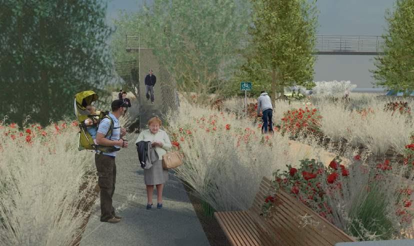
·Separate pedestrian, bicycle, and vehicular realms to create safe circulation using complete street design techniques
·Connect Easton Beach to the surrounding area attractions and greater Newport using pedestrian paths and bikeways
·Design Infrastructure that considers the additional burden of seasonal use during the Summer months
Kimberly Justham
North Easton Pond looking south
The study area for the senior studio in the spring of 2016 is composed of Easton Beach, Memorial Boulevard (RI 138A), and South Easton Pond. Located on the eastern boundary of Newport Rhode Island, the land area of from ocean edge to the water edge at the reservoir is approximately 50 acres; additionally the water surface area of South Easton Pond is about 140 acres.
This area is of particular interest due to it’s complex environment and vulnerability. With a drinking water reservoir and ocean in close proximity, as well as a popular beach and dense residential area, the site has many layers to consider when planning a design concept.

Site Location & FocusArea

Focus area showing Easton Beach, Memorial Boulevard (RI 138A), and South Easton Pond; total area: approx. 190 acres

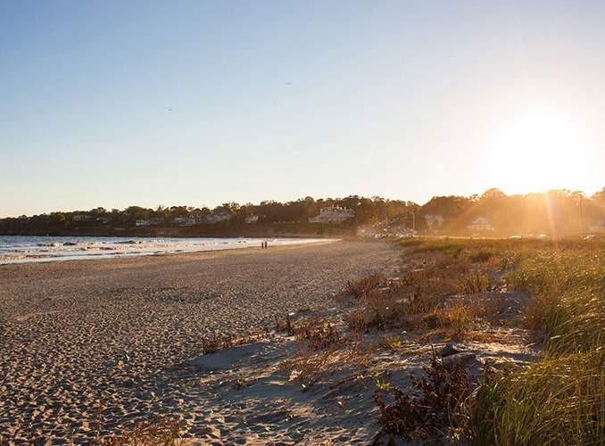
Easton Beach facing South
Site Analysis

Summary &Conclusions
·Minimal nativevegetation on both beach &pond withlittle diversity
· Significant impermeable surfacearea
·Vulnerable builtinfrastructure(parking areas,Easton Beach facilities, protective levees around Easton Pond, Memorial Boulevard)
· Fresh and salt water pollution
· Damaged and vulnerable habitats
·Primary drinking water source vulnerable to saltwater intrusion, sea level rise, and storm surge
·Heavy seasonal use is a valuable revenue source for the city
By Amit Chattopadhyay - originally posted to Flickr as Easton Beach - Panorama 2
Existing Environment
South Easton Pond and Easton Beach lack a substantially developed natural habitat. At the pond’s southern edge, the ground is dominated by open lawn area. Close-mowed turf grasses which attracts undesirable species such as geese, contributes substantially to non-point source pollution in both the moat and in the pond. Studies of the pond have reported observing as many as 500 geese grazing on the lawn at a time, making them a substantial nuisance to residents and severely detrimental to the habitat The shores of both the moat and the south pond are sparsely vegetated with herbaceous species providing little habitat value and are often mowed seasonally to maintain access to the levee and moat. Around the North Pond, there is more vegetation, mostly wetland shrubs and thicket, but is dominated by invasive species that detract from vegetative diversity and provide little benefit to animal habitat.
The moat itself has some potential for freshwater species, but with minimal protection and a lack of nutrients, there is likely little aquatic or amphibious life currently. Similarly, the pond is home to a variety of waterfowl and probably a number of turtles as well as a limited fish population. Due to high water temperatures, a lack of vegetation, and poor water quality, the potential of the pond to sustain a diverse ecosystem is severely reduced.


Photo Credit: KimberlyJustham Ducks; considered a desirable species in wetland environment
Photo Credit: KimberlyJustham stormwater runoff moat encircling south pond
Photo Credit: KimberlyJustham
Above: Isometric section of Easton Beach and South edge of Easton pond
Left: Drainage outfallinto stormwater moat
Credit: Zaire Garrett

Land use map showing beaches, residential, commercial/industrial, and water wetlands on the Easton Beach & Easton Pond site.
Some habitat restoration is already underway along the beach edge. Dune restoration areas are in place on both the east and west sides of the parking lots to try to bring back some of the species that would have maintained a natural dune system. Dunes are an effective protective measure for beaches, and the area behind them, if they are allowed to change and move naturally. The dunes at Easton beach are abutted by the sea wall and road on their landward side, which does not allow for the natural migration of the system. Additionally, pedestrian traffic across the dune has done damage to the sensitive grasses that make up this ecosystem. The result is that these dune restoration projects have met with mixed success. Any ecological improvement is a step in the right direction, but these narrow strips of vegetation do not go far enough to provide protection for the beach or substantially improve the environment. Students therefore had to decide whether the dune structure was worth maintaining in it’s current form, whether a more substantial system was needed, or even to remove the dunes all together in favor of a more engineered protection measure.

restoration along Easton Beach has had mixed success. Some areas have developed well, while others (pictured above) continue to struggle to establish. Design methods to improve the water quality of Easton Pond should focus on reducing non-point source pollution. The large number of geese in the area are significant source of pollution in runnoff, and interventions should take steps to reduce the population of these large waterfowl. This can be done very simply by reducing the mowed lawn area to discourage geese from landing to forage. This would reduce beach closures and increase water quality by lessening the contribution of animal waste to stormwater runnoff. Implementation of biofiltration measures to treat stormwater would also be a benefit to water quality and increase vegetative biodiversity in the area.
Dune
Photo Credit: VictoriaBockstael

Water Quality
Bailey’s Brook is a 4.8 mile stream that drains an area of approximately 2000 acres in Newport and Middletown. Runoff from this watershed area comes from highly developed residential and mixed use areas as well as a plant nursery to the northernmost edge of the watershed.
The stream outflows into North Easton Pond, which is connected to South Easton Pond, which flows directly into the Atlantic Ocean. Both ponds serve as a primary drinking water source for Aquidneck Island, for which the water treatment facility is located on the western corner of the causeway separating the two ponds.(RI TMDL)

In September of 2011, the Rhode Island Department of Environmental Management performed summary of Bailey’s Brook Watershed that analyzed the Total Maximum DailyLoad forbacteria impairedwaters. During this time the RIDEM collected water samples from multiple locations along Bailey’s Brook and Easton pond and tested for indicator bacteria, which led to the stream’s status as an impaired water source.
The study found multiple sources of contamination to the water flowing into Easton Pond, the majority of which are due to stormwater impacts. With a 32% impervious cover, and multiple outflows directly into the Brook, stormwater is a major contributor to elevated phosphorous levels in the water as well as other pollutants associated with heavily populatedareas.
Additionally, the report attributed onsite wastewater treatment systems, sewer leaks for contributing to pollution in the stream. Nurseries to the north have is also suspected of contributing to elevated phosphorous levels due to their agricultural activity within the watershed. Also, waterfowl and other wildlife have been identified as a major source of contamination in both the north and south pond. (RITMDL).
The elevated levels of phosphorous in Bailey’s Brook have contributed to blue-green algae blooms in South Easton pond. Blue-green algae thrives in high phosphorous bodies of water with elevated water temperatures. Runoff from high density residential areas such as those around the brook contribute pollutants from lawn fertilization and sewage contamination. A large population of seasonal waterfowl also contributes animal waste to the area which often runs directly into the water supply during a heavy rain event.
In 2015, the Rhode Island Department of Health put out a press release warning against human contact with the water in South Easton Pond. The press release stated that “Irritation of the skin, nose, eyes, and or throat are common side effects that result from skin contact with water containing agal toxins. If water containing agal toxins is ingested, health effects include stomach ache, diarrhea, vomiting, and nausea.” The press release also states that Newport’s public drinking water supply is not at risk (Blue-Green Algae).
Improving water quality in Bailey’s Brook and Easton Pond is a multilevel issue. There are many contributing factors that effect the water quality, as is outlined in the RI DEM report. To reduce pollutants in Bailey’s Brook, a policy and culture shift is necessary. Newport must adapt a policy of low impact development in drinking-water supply watersheds, as well as shift the public culture to reduce the use of fertilizer in privatelandscapes.
From a design perspective, there are several strategies that can mitigate pollution and algae blooms in Easton Pond. Improving existing wetlands and constructing new wetlands to filter can help to reduce phosphorous and heavy metal pollutants. Reducing the lawn area around Easton pond would also help to discourage waterfowl from foraging in the area, which would reduce animal waste in the pond.

Easton Beach& Tourism

Newport is a major center of tourism in the state of Rhode Island. It’s estimated that 3.6 million people per year visit Newport shops, beaches, restaurants, and historic sites every year. This is in addition to the 24,000+ residents of the city, as well as college students at Salve Regina University. Tourist related industries account for one of two industries that employs Newport residents; The U.S. navy is also employs a major portion of the population at about 6,000 civilian and militarypersonal.
The ocean is the main piece of Newport’s culture, and it’s beaches are a major attraction for tourists coming from throughout the northeast. Easton Beach, known locally as First Beach, is the only city owned beach within Newport’s town lines. Sachuest Beach is east of Easton beach, and falls under Middletown’s jurisdiction. In all, there are ten public and private beaches on Aquidneck Island drawing crowds for a mix of surfing, sailing, and swimming.

Parking at Easton beach is approximately 660 spaces which charge daily for use during the summer months (above: western parking lot at Easton Beach)

Easton Beach has approximately 660 public parking spots thatcost $10dailyduring thesummer seasonwith increased rates during holidays. Additionally there is limited street side meter parking adjacent to the beach and accounts for approximately 20 parking spots. All parking is free during the off season throughout the city. Parking is a primary source of revenue for Easton Beach, which operates as a separate branch of the Newport city government. In 2015, Easton Beach reported taking in approximately $540,000 in revenue from parking alone. Additional revenue comes from the snack bar on the beach, rental of the Rotunda Ballroom event space, and beach cabanas that are used for storage. (Newport Daily News)
During the summer months, the beach is fully staffed with lifeguards during daylight hours, and is mechanically raked every day to remove trash and seaweed. Theremovalandoff-sitedisposalofseaweed has reduced the amount of debris in the water and has improved water quality on Easton beach, reducing the yearly number of beach closures. vvv
Photo Credit: Newport Daily News
Easton Pond pedestrian path along the top of the levee
Photo Credit: Bing Maps
Seaweed harvester used on Easton Beach to improve water quality (photo credit: Newport Daily News)

https://kimgorman.com/2015/06/21/guide-to-affordable-newport-rhode-island/ Easton Beach, Newport Rhode Island during summer
With Easton Beach being a major source of revenue for the city, reducing beach closures has been a high priority. Elevated bacteria levels on and in the water will trigger a 24 hour suspension of swimming on the beach. Predominately, a rain event of an inch or greater will trigger an automatic beach closure due to a flushing of the stormwater drainage system into the ocean. The moat surrounding Easton Pond manages outflow from the stormwater system draining Bailey’s Brook watershed, which drains directly onto the beach.
In an effort to reduce the beach closures, the City of Newport installed an ultra violet treatment facility to sterilize stormwater runoffof bacteria before itoutfalls onto the beach. The facility has been successful for the water loads it was designed for. According to beach officials, the facility treats typical flow of water during a dry day up to one inch. During a storm event of greater than one inch, the flush overwhelms the treatment facility, which then discharges untreated water onto the beach.
The UV treatment facility combined with removing seaweed from the sea shore has had the effect of reducing the overall number of closures on Easton Beach. During major rain events, system flushing is still a major issue and often results in 24 hour closures.
There are additional strategies that can be implemented to reduce the effect of rain events on water quality. The overall goal of any design would be to reduce the quantity of untreated water flowing into the ocean during a rain event. This would be done by redirecting storm water into treatment wetlands, rain gardens, bioswales, and retention basins, to retain water and delay it’s release so that it can be infiltrated, or treated before its released into the ocean. Treatment wetlands have been shown to have a significant effect in improving stormwater management and reducing bacteria as well as phosphorous in water, as well as allowing heavy metals to precipitate out of water before entering either Easton Pond or the ocean. Additionally treating stormwater and allowing it to enter Easton pond instead of outflowing would increase water storage forAquidneck Island.

Charts showing annual beach closures of Easton Beach and typical annual precipitation in Newport, RI

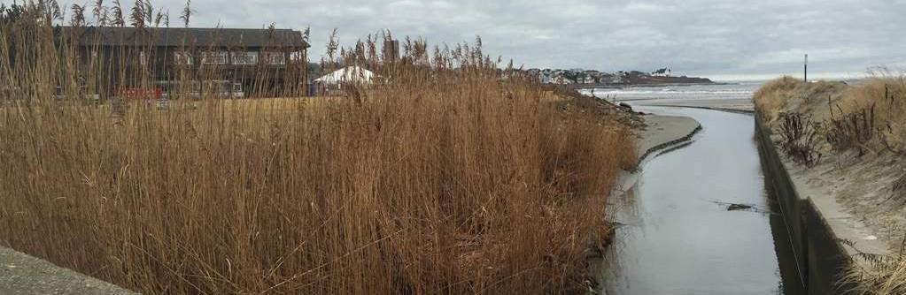
Photo Credit: VictoriaBockstael
Stormwater outflows directly onto the beach after it is treated by the UV Facility
Climate Change
For any coastal community, climate change is quickly becoming a paramount concern. Much of Newport lies on bedrock well about the ocean, and is therefore protected from many of the storms and even the greatest predictions for sea level rise. Several neighborhoods in Newport though, are extremely vulnerable to the advance of the sea. Downtown Newport, home to many historic buildings as well as the main retail center of the city is particularly vulnerable to rising waters. At an elevation only a few feet above sea level, Superstorm Sandy (Nov. 1, 2012) caused flooding through much of downtown Newport, home to many government and historic buildings.
The area of Easton Beach and Easton Pond are also in a very vulnerable position. The maximum elevation of the site is approximately nine feet above mean high water in the parking lot. Grade drops down to Memorial Boulevard before rising up to the levee at approximately 12feet. To the east and west, the land slopes up through the residential neighborhood. The houses in these neighborhoods are relatively protected from inundation due to the rise in elevation on the east and west on Easton Pond, but the structures on the beach, as well as the roadway and reservoir are particularly vulnerable to both storm surge and sea level rise.


Beach erosion and sea level rise have already become an issue for Easton Beach. The shoreline change map below illustrates the retreat of the beach due to erosion in addition to the sea level rise that has already taken place in New England. Since 1900 the sea level has risen about 8 inches with the most drastic changes within the last 50 years. Because the stretch of land between the ocean and the reservoir is only 400 feet wide on average, any amount of sea level change inundates what little land is left (Climate Central).
Additionally, sea level rise will increase the damage that could be caused during a major storm event. Flooding for 25, 50, and 100 year storms inundates much of the beach and the road, but when this is compounded by sea level rise, the ocean would flood the south reservoir, as well the low lying homes to the east and west, and, in extreme scenarios, flooding would inundate the north pond and upper portions of Bailey’s Brook. When you combine this with projected wave heights, it becomes apparent that the drinking water reservoir serving much of Aquidneck Island, as well as much of Easton Beach and existing structures on the beach are in a very vulnerable state.

Left: the shoreline change map shows the retreat of the shore on Easton beach over the last 70 years. when combined with sea level rise projections, this indicates that Easton beach will be inundated in a matter ofdecades.
Wave heights of 12-20 feet during a 100yr storm event would do severe damage to this area of Newport


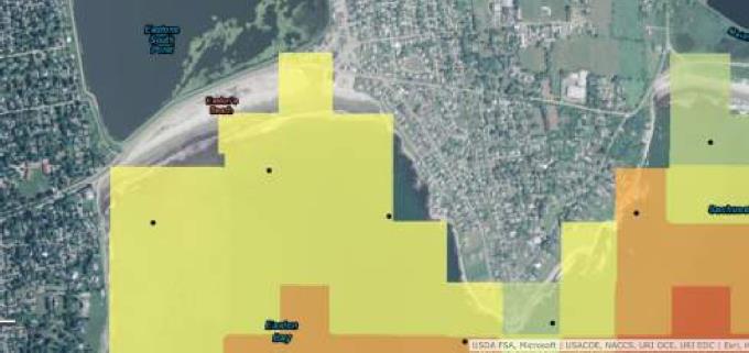
STORMTOOLS (developed by BeachSamp RI), maps showing inundation under 25, 50, and 100 year storm conditions, taking into account different levels of sea level rise. Base flood levels with no sea level rise could potentially inundate South Easton Pond during even a 25 year storm, though itis hard to predict actual damage due to the effect of wave action on the levees in this area.

Easton Beach (0ft)
Parking area(9ft)
Sea Wall (10ft)
Dune Restoration
RI 138A (5 ft)
Easton Pond southern Levee (10ft)
Easton Pondwater Level (5ft)
25 yearstorm
100year storm
50 year storm
Above: Isometric views showing 1ft,3ft,and5ft of sea level rise on a sections of Easton Beach (credit: Zaire Garrett)
Below: section cut of western Side of Easton Beach to Easton Pond. Elevations are above NAVD88 (Source: Google Earth)
Built Environment


Newport has a rich history stemming back to the Native Americans in the pre-colonial era. Native tribes had established Newport as a summer fishing and farming land due to it’srich soil, abundant fisheries, and presence of fresh water. Colonists founded the modern settlement in 1639, and it quickly became a hub for trading and manufacturing in the region. But Newport was left behind during the industrial revolution in the U.S., and the town suffered economically for many years. Newport had a resurgence during theguilded age in the late 19th century, becoming a summer retreat for industrialists, philanthropists, and millionaires. The city established itself as starkly divided between the island’s rich, living in lush mansions along the coast, and the working class who served them and worked on and around the island.
Today, the city remains similarly divided among the upper and working class. Property values can climb into the millions in some parts of Newport, but the average income per capita in the city is approximately $40,000, and the majority of Newport’s permanent residents are middle class workers (RI DLT). The wealth of Newport remains in seasonal residents, and the mansions that were once occupied by the nation’s top one percent have become a shrine to the guilded age in the northeast and a centerpiece of Newport’s culture. The Cliff Walk connects tourists to the city’s rich culture via a walking path that runs along the edge of the ocean and allows users to view the historic mansions as they walk the path. The start of the Cliff Walk is on Memorial Boulevard on the western corner of Easton Beach, and many beach goers also use the cliffwalk as part of theirexperience on the beach.
MemorialBoulevard facing Easton Beach; circa1900
Easton Beach 1930s
Easton Beachpre-industrialization; 18th century
Easton Beach Rotunda; circa 1900
All photos courtesy of Providence Public Library
In 2011, Vanasse Hangen Brustlin completed the Aquidneck Island Transportation Summary, which was commissioned by the Aquidneck Island Planning Commission and included a comprehensive study of roadways and transportation systems throughout Aquidneck Island. Of interest to this project was data collected for Memorial Boulevard, which is the multi-lane roadway running adjacent to Easton Beach and Easton Pond. The study stated that approximately 22,100 vehicles move along Memorial Boulevard per day during the summer season, with peak times between 3:00 and 4:00 pm .Additionally, 100 pedestrians were observed along memorial boulevard during peak hours, most likely walking along the side walk to the cliff walk entrance. While RIPTA public transit services much of Newport and Aquidneck Island, there is no dedicated stop at Easton Beach, which means there is an additional burden on parking because there a minimal transportation alternatives to the beach Memorial Boulevard itself is three to four lanes wide with additional street side parking on the western side. It is a 25mph speed limit, though the study indicated that vehicles have been observed going as fast as 60mph down the road. There have been multiple incidents involving cars and pedestrians in the last several years, including three fatalities involving either cyclists, pedestrians, or handicap persons in the vivacity of Easton Beach.
Improving pedestrian safety and connectivity is of paramount importance to a complete design intervention, and would involve creating a separated pedestrian realm and/or dedicated bikeway. The City of Newport has recently adopted a policy of complete streets, which is a design strategy of integrating bike routes into roadways to make a safe environment for cyclists.
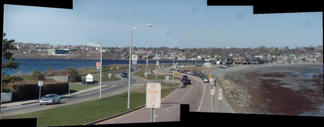

Existing conditions on Memorial Boulevard (RI 138A); photo credit: Joshua Bourgery

Existing conditions of Easton Beach and Memorial Boulevard at low tide: February 15,2016 (photo credit: Joshua Bourgery)
Student Design Proposals

The following pages include selections of student work used in their final design presentations. Pieces of completed student work have been organized by graphic style and design strategy in order to give a clearer picture of both the design process and a summary of student proposals for the site.
Concept Sketches


During the design process, many students find it’s helpful to use hand sketches toaidtheirthought process. This allows for quick transfer of ideas to paper and enables the students to work through complex problems like those associated with Easton Beach and Easton Pond. Some students used bubble diagrams, like the one shown above, to identify areas on the site and generalize the design intent of each area. Other students worked with more detailed sketches over a printed base map, which facilitated them to work through some design challenges before committing time to the digital form. One student colored and labeled her plan for use in the presentation.
Eric Sauer
top left, bottom Ka Ying Yang
Graphic Visualizations


For presentations, students are often asked to include graphics that clearly illustrate their design intent. While plan view drawings are useful, perspective renderings and photo-realistic graphics can help people to easily understand certain components of the design that may be difficult to represent in plan view, especially on a large site like Easton Beach.


Ka Ying Yang: Perspective renderings showing pedestrian path
Joshua Bourgery: Rendering showing large section of beach with a large dune system and bridge
Top and bottom, Zaire Garrett: Renderings showing pedestrian spaces and integration of green energy as well as historical context
Rendered Plans
Due to the large size of the focus area, many students chose to represent their designs in part using rendered plans set at one inch equal to 200 feet. These plans were made using a base image collected from the Rhode Island GIS database which was then rendered in Photoshop and AutoCAD. By presenting their designs in this way, students could show how theirdesigns fitin to the existing conditions and related to the area. These plans were supplemented with perspective renderings that showed some design components in moredetail.


Eric Sauer: Plan view illustrating a concept for renewed green space and eco-bridge
Joshua Bourgery: Rendered plan view of proposal to integrate a larger dune system and relocation of parking area to the north side of Memorial Boulevard

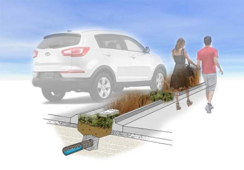
Victoria Bockstael: Design in plan view showing reorganized parking and green space as well as biofiltration areas for stormwater runoff

Ka Ying Yang: Proposal to reduce parking areas and impermeable surface to increase the site’s dune restoration and green space

Complete Streets
Many students opted to reconfigure Memorial Boulevard using a complete streets system. 'Complete streets' is a national initiative to integrate bikes and pedestrians into roadway design to create a safe environment for all users. There are many variations on the system and each student who chose to reconfigure the road addressed the problem in a different way. Some students, like Antone Almedia - whose renderings are shown left and bottom - chose to completely separate cars, pedestrians, and bikes by creating individual lane-ways separated by vegetated strips, to provide the maximum safety for each user. Other students designed roadways with bike lanes as part of the main road, as is often seen in cities. Areas designated for cyclists would be called out using road markers and signage and can be seen in renderings on page 27. Finally, many students increased pedestrian safety by increasing lighting and signage to alert drivers to pedestrian crossings as well as changing pavement type, color or texture

left, right: Antone Almeida: Isometric and perspective views showing a complete street system with separated pedestrian and bike-ways from vehicles
These perspectives show different strategies for complete street systems, the top photo shows completely separated pedestrian and cyclist lane, while the renderings on the bottom and right show roadways which distinguish pedestrian and cyclist areas through change inpavement.


Victoria Bockstael: Changing pavement type and texture alerts drivers to conflict zones
Beau Doucette: Visual signals for pedestrian crossings
Ali Ludas: Changing pavement color highlights cyclist zones
Alec Mihailides: Driver’s perspective of complete street
Antone Almeida


Pedestrian Bridges
To address the incidents of pedestrian fatalities and injuries on Memorial Boulevard, some students chose to connect the beach facilities and walking areas around Easton Pond via pedestrian bridges. One student proposed to connect the existing rotunda facility with pedestrian and bike paths with a conventional elevated pedestrian bridge, that would ensure that there’s no conflict between pedestrians and vehicles on that part of memorial boulevard. Other students proposed eco-bridges, or ecoduct designs for pedestrian bridges, that involved planting vegetation on and around the bridge to create a natural connection between the beach and the pond. The benefit of these types of bridges is that they create a unique and natural experience for users and are a less invasive addition to the landscape.


Above: Joshua Bourgery: perspectives of eco-bridge concept
Eric Sauer
Antone Almeida
Zaire Garrett
Above and below: Sections showing the integration of pedestrian bridges into the sitedesign


Of great import to modifications of Easton Pond, is improving the quality of water both entering and exiting the reservoir. Many students chose to address the issue of stormwater management in their concepts. Multiple students integrated bioswales, constructed wetlands, and/or filter strips into their design to infiltrate and naturally filter out particles in stormwater runoff before it is directed into the pond. Several students also took steps to retain stormwater to prevent a flush the would overwhelm the UV treatmentfacility.
Stormwater Management

Ka Ying Yang: Constructed wetlands proposed adjacent to Easton Pond
top, bottom: Doug Stonis: Bioswales proposed for parking areas
Victoria Bockstael: Center median rainwater filter strips

Road Protection
Memorial Boulevard is an important connector road for Newport and Middletown. Thousands of cars use the road every day and keeping the road open during the harshest conditions is vital. Several students recognized this and took steps to protect the roadway. One student took steps to envision a long term solution to beach erosion and vulnerable infrastructure by allowing the beach to be inundated and replacing all existing structures with a raised causeway. This student felt that the importance of keeping the road open outweighed the cost of losing Easton Beach as it exists. Another student designed an elevated road that stood 20 feet above the existing grade and would serve as a through-way for traffic between Middletown and Newport, while a secondary road would service the beach at ground level. While these designs are radical, they represent students identifying the need to propose different and at times controversial solutions to protect infrastructure from risingseas

Emily Sanchez: This student proposed an elevated roadway to maintain Memorial Boulevard. She suggested that creating raised infrastructure like this would maintain the area as exists while increasing resilience to storms and sea level rise
Alec Mihailides: This student proposed creating an armored causeway to maintain use of Memorial Boulevard during even the harshest weather conditions; he argued this was of greater importance than attempting to maintain the beach, and was therefore justified in removing Easton Beach.
Presentation Boards
For the final presentation, each student was required to compile one to two 24 by 36 inch boards to accompany their oral presentations. The students were directed to include all the parts of their design concept and provide a description of their
proposal so that the boards could be understood without the student present. The boards were displayed around the room during the presentation and several are shown in their entirety below and on pages 32 and 33.


Credit: Brian Whelan. This student endeavored to create a new economic function for Easton Beach and Easton Pond. He justified that because salt water intrusion into South Easton Pond was imminent and there was no viable solution to prevent it, there was a precedent to land fill the south pond. This student suggested that by filling the pond, one would create sufficient land area to incorporate a golf course which would draw a different set of patrons to the area and increase the economic diversity.


Conclusions andBenefits
Given the vulnerability of Easton Beach and Easton Pond to both storm surge and sea level rise, as well as salt water intrusion and pollutants, it is clear that intervention is needed to save this site. The economic benefit of the beach and its importance as a tourism site underscores the importance looking toward the future, and realizing the inevitable challenges that face the shore.
Sea level rise and climate change are global issues that are faced by coastal communities around the world. And with the sea growing higher every year, innovative and creative solutions must be considered to save coastal infrastructure. Student projects such as the one outlined in this report are of tremendous potential benefit to professionals in landscape architectural coastal design, coastal planning and resources as well as the community at large. Students are able to explore ideas free from the constraints of cost-benefit analysis or industry norms, in order to foster discussions about design innovation and unconventional solutions. Additionally, student work in the form of reports can be used to spur community engagement on climate change, and open discussions about preparations for sea level rise and storm resilience.
At Easton Beach and Easton Pond, steps must be taken toestablish a time line for the site. Officials must determine whether a design must be applicable 25 years, 50 years or longer and whether efforts should be made to maintain the beach and reservoir in their current condition. Students, free to make these design decisions on their own, proposed both short and long term solutions, as well as concepts that completely removed beach access, and those who tried to maintain it by armoring the beach. This freedom allowed a wide range of ideas to materialize and ultimately had the benefit of providing readers with concepts spanning an entire range of site design.

References
“Aquidneck Island Transportation Study.” Aquidneck Island Transportation Study. Vanasse Hangen Brustlin, July 2011. Web. 21 May 2016. <http://projects.vhb.com/aquidneck/default.asp>.
“Community Profile.” City of Newport :.Web. 21 May 2016. <http:// www.cityofnewport.com/departments/planning-development/ community-profile>.
Rhode Island CRMC Shoreline Change Special Area Management Plan, University of Rhode Island Coastal Resources Center, Rhode Island Sea Grant,Teresa Crean, <www.beachsamp.org>
Rhode Island Department of Environmental Management. Rhode Island Statewide TMDL for Bacteria Impaired Waters, Bailey’s Brook Watershed Summary. Sept. 2011. Web. Apr. 2016. <http:// www.dem.ri.gov/programs/benviron/water/quality/swbpdf/ bailey.pdf>.
Rhode Island Geographic Information System, The University of Rhode Island, Rhode Island Division of Planning, <www.rigis.org>
Sheley, Matt. “Beaches Were Hot Draw.” NewportRI.com L News and Information for Newport, Rhode Island. 5 Sept. 2014. Web. 21 May 2016. <http://www.newportri.com/newportdailynews/ news/page_one/beaches-were-hot-draw/article_3eeff815d339-5067-8f48-bcf3d84da8c3.html>.
Photos as cited in report