
MANAGEMENT PLAN UPDATE


ACKNOWLEDGMENTS
PROJECT TEAM
NORTH CENTRAL CONSERVATION DISTRICT
Joanna Shapiro Fiscal Agent/Project Oversight
FUSS & O’NEILL
Erik Mas, P.E.
Akta Patel, P.E.
Sarah Hayden, MSc, MBA
Caitlin Strzegowski, EIT
Andrew Bohne, RLA
Faith Long
Sara Lawler
Sage Hardesty
Sara Morrison, MLA, WEDG
MERI LLC WITH PARK WATERSHED
Mary Rickel Pelletier Project Coordinator
TRUST FOR PUBLIC LAND
Walker Holmes Engagement Advisor
Brian Martin Community Engagement
Cally Guasti-O’Donoghue Communications
PROJECT PARTNERS
CAPITAL REGION COUNCIL OF GOVERNMENTS (CRCOG)
Matt Hart Executive Director
Caitlin Palmer, AICP Director of Regional Planning & Development
Maureen Goulet Principal Program Manager, Regional Planning & Development
Heidi Samokar AICP Principal Planner
Sonya Carrizales Environmental Planner
CITY OF HARTFORD
Frank Dellaripa City Engineer, Assistant Director Department of Public Works
Nicholas Casparino Civil Engineer, Department of Public Works
Randal Davis Deputy Director, Planning Division
Owen Deutsch AICP Principal Planner, Planning Division
Janice Castle Office of Community Engagement
CONNECTICUT DEPARTMENT OF ENERGY & ENVIRONMENTAL PROTECTION (CT DEEP)
Erik Bedan Supervising Environmental Analyst, Water Protection & Land Reuse/ Water Planning & Management
Marlene Krajewski Environmental Analyst, Water Protection & Land
Reuse/ Water Planning & Management
Christopher Bellucci Assistant Director, Water Protection & Land Reuse/ Water Planning & Management
METROPOLITAN DISTRICT (MDC)
Jason Waterbury, P.E. Assistant Manager of Engineering
Jeremy Galeota, P.E., BCEE Project Manager
NATURAL RESOURCES CONSERVATION SERVICE (NRCS)
James Lyons, P.E. State Conservation Engineer
PROJECT ADVISORY COMMITTEE
Denise Savageau CT Association of Conservation Districts (retired)
Alicea Charamut Executive Director, Rivers Alliance of CT
David Mann Resident, Design Review Board, Town of Bloomfield
David MacDonald Asylum Hill Neighborhood Association
Kyle Bergquist/Blair Hughes West End Civic Association
Marion Griffin Hartford NEXT
Evelyn Green Resident, Blue Hills neighborhood
Janice Castle Office of Community Engagement
Mike McGarry Chair of the Hartford Flood Commission
Julie Viera Town of West Hartford
Yaw Owusu Darko CT Land Conservation Council
Amy Patterson CT Land Conservation Council
Alex Dahlem/Grady Brockway Aide to State House Speaker Ritter
Kellie Guilbert Aide to State Senator McCrory
Marilyn Bantz CT DAS Property Manager
Ashley Stewart CT Green Bank
Zbigniew Grabowski UConn CLEAR
This project has been funded wholly or in part by the United States Environmental Protection Agency under assistance agreement LI-00A01075 to the National Fish and Wildlife Foundation. The views and conclusions contained in this document are those of the authors and should not be interpreted as representing the opinions or policies of the U.S. Government or the National Fish and Wildlife Foundation and its funding sources. Mention of trade names or commercial products does not constitute their endorsement by the U.S. Government, or the National Fish and Wildlife Foundation or its funding sources.
RATIONALE FOR THIS PLAN AND NEXT STEPS
Plan Rationale
This 2025North Branch Park River Watershed Management Plan is a living document that advances previous research and implementation strategies initiated by the original 2010Plan. Although most of the North Branch subwatershed is within Bloomfield (74%) and West Hartford (22%), this plan update focuses on site-specific riparian corridor conditions within City of Hartford neighborhoods. This 2025Plan reveals how conservation and restoration of the North Branch can embed benefits of green infrastructure into high-density urban communities.
While conservation and restoration of the North Branch Park River riparian area may seem ambitious, this is a surprisingly cost-effective solution to accumulated problems that negatively impact water quality and public health. While watershed management plans are intended to address water quality concerns, there are numerous environmental problems directly related to the degradation of the North Branch. Investments that recognize water quality as a measure of success can spark other vital improvements.
Envisioning the North Branch Park River as a healthy urban-suburban riparian corridor is rooted in Olmsted’s 1871observation that the natural beauty of the North Branch should be protected from degradation by distancing new streets away from the river. Research has now confirmed Olmsted's observation that plant ecosystems can filter (“buffer”) stream water from roadways pollutants, and that these environmental impacts can also deteriorate quality of life for the community.
The success of recent urban river restoration projects in other cities is encouraging as is the longevity of prosperous historic precedents that trace to Olmsted. North Branch participants in a recent community survey indicated strong
support for the following four goals: 1) conserve wooded lands along the North Branch; 2) replace derelict parking lots with wetlands or meadows; 3) remove invasive plants species to revive native ecosystems; and 4) increase safe public access to the North Branch Park River.
The 2025North Branch Park River Watershed Management Plan provides details to fulfill those goals.
Next Steps
Although this watershed management plan provides extensive details of refined GIS maps that clarify drainage patterns, this project scope did not include detailed hydrologic and hydraulic analysis. Our work included significant community outreach, interactive experiences, and educational programs. However, further neighborhood urban design and economic development studies as well as incentivized negotiations with institutional property stakeholders are needed to realize a vibrant North Branch. The proposed present-day vision for revitalization of the North Branch Park River riparian corridor includes:
• Formation of a North Park Task Force dedicated to furthering implementation of the 2025Watershed Plan.
• Securing funding for an economic development and urban design study that can build upon the 2025Watershed Plan by addressing financial and legal concerns of property owners; and possible incentives and policies that can support green infrastructure, as well as locations of safe public access.
• Formal conservation of riparian areas and floodplains that are properties of the State of Connecticut or watershed municipalities,(Hartford, Bloomfield and West Hartford) to increase connectivity and protection of environmentally sensitive riparian areas.
The Emerald Necklace, (left and below) is one of many examples of how conservation of urban riparian corridors can be accomplished. The sustained longevity of the Emerald Necklace's traces to F. L. Olmsted's 1874 design that transformed Boston's Muddy River by protecting the riparian corridor and connecting it to large gem parklands.
Conservation of riparian area that surrounds urban streams, such as the North Branch Park River, is an increasingly relevant feature of successful 21st century urban neighborhood revitalization.


North Branch Park River riparian areas (above in green). The mainstem is formed at the convergence of Beaman's and Wash Brook south of Cottage Grove Road in Bloomfield. The North Branch flows visibly through four City of Hartford neighborhoods before entering a buried conduit at Farmington Avenue.
CONTENTS (CONTINUED)
LIST OF APPENDICES
Appendix A: Status of Recommendations from the 2010 Watershed Management Plan
Appendix B: North Branch Park River Watershed Community Survey and Results
Appendix C: Potential Funding Sources
Appendix D: Site-Specific Green Infrastructure Recommendations
Appendix E: Green Infrastructure Preliminary Design Plans
Appendix F: Green Infrastructure Permit Level Design Plans
Appendix G: Anticipated Permits and Approvals
1. INTRODUCTION

Background Prior Watershed Planning Status of 2010 Plan Why Update the Watershed Plan? Plan Update Process Community Engagement
BACKGROUND
North Branch Park River
The North Branch Park River is an urban river that flows approximately 5.4 miles through four neighborhoodsin the City of Hartford, including the last unmodified riparian landscape along the river corridor in Hartford. Four major tributaries – Beamans Brook, Wash Brook, Filley Brook, and Tumble Brook – drain from Bloomfield and northern parts of West Hartford converging near the University of Hartford to form the North Branch of the Park River.
The North Branch Park River flows into an underground flood control conduit just upstream of Farmington Avenue. The conduit carries the North Branch for another 0.5 mile to its confluence beneath I-84 with the South Branch Park River forming the Park River, which flows underground for roughly 2.5 miles to the Connecticut River.
The North Branch Watershed
The North Branch Park River watershed is an approximately 29-square mile sub-regional basin within the larger Park River regional watershed (50 squaremile watershed) of the Connecticut River basin. Most of the watershed land area is located within Bloomfield (68%), West Hartford (17%), and Hartford (12%).
The North Branch Park River and its watershed, as it exists today, reflect the historical development of the Hartford metropolitan area, including many significant changes that have altered the development patterns along the river and within its watershed, the physical characteristics of the river, and even the name of the river itself. The watershed is home to approximately 48,000residents, numerous institutional facilities and campuses, and sites of historical and cultural significance including the Harriet Beecher Stowe House, the Mark Twain House, and Elizabeth Park.
Impaired Water Quality
Today, the water quality and stream flows of the North Branch Park River have been impacted by urbanization within the Hartford area. The poor water quality in
portions of the North Branch Park River limits recreational uses due to elevated levels of fecal indicator bacteria and provides insufficient habitat for fish, other aquatic life, and wildlife due to physical alteration of the above-ground and buried portions of the river. The river is considered “impaired” for these uses. Urban stormwater and combined sewer overflows (discharges of untreated wastewater directly to the river during larger storms when the combined storm and sanitary sewers become overwhelmed by stormwater runoff) are among the major sources of the bacterial contamination in the North Branch Park River. The North Branch Park River also contributes nutrients to the Connecticut River and ultimately Long Island Sound, which suffers from excess nitrogen loading and low dissolved oxygen levels.
Although the flood control projects of the last century have protected the City of Hartford from the type of catastrophic floods that occurred in the 1930sand 1950s, channelization and burial have significantly altered the North Branch Park River, especially south of Farmington Avenue. These changes have disconnected the river from the surrounding communities and have contributed to the river’s deteriorated water quality and degraded habitat conditions that exist today.
Nevertheless, there are significant riparian landscapes in the upstream portions of the watershed and even within the City of Hartford that provide valuable ecosystem service benefits. Protection of these landscapes as well as headwater areas from potential water quality impacts from future land development is a priority for the overall health of the river. Additionally, there is opportunity to restore developed areas such as derelict parking lots within the floodplain as floodable meadow landscapes that will contribute to improved water quality, scenic vistas, and overall resiliency of the river and the surrounding city communities

PRIOR WATERSHED PLANNING
2010 North Branch Park River Watershed Management Plan
The Connecticut Department of Environmental Protection (now the Connecticut Department of Energy and Environmental Protection), working with local stakeholder groups, recognized the need to address the water resource issues of the North Branch Park River using a watershed-based approach. In 2007, the CTDEP retained a project team led by Fuss & O’Neill, Inc. and including the Farmington River Watershed Association and the Park River Watershed Revitalization Initiative, to develop a watershed management plan for the North Branch Park River.
The watershed management plan, completed in 2010, was developed consistent with the U.S. Environmental Protection Agency (EPA) and CTDEP “nine elements” guidance for development of watershed-based plans. The plan synthesized information from earlier studies and reports on the watershed, Geographical Information System (GIS) mappingand analyses, review of land use regulations, and detailed field assessments to document baseline watershed conditions, the potential impacts of future development in the watershed, and recommended actions to protect and restore water resource conditions. The 2010plan was also developed with input from a project steering committee and significant public outreach.
Among the top priorities of the 2010plan were recommendations to form a watershed stewardship organization, implement demonstration restoration and retrofit projects, modify zoning regulations to protect water quality, conserve last landscapes and advance community outreach. The North Branch Park River Watershed Management Plan was approved by EPA and CTDEP in 2010.Implementation of the 2010 Plan goals include changes to City of Hartford zoning regulations as well as construction of green infrastructure features.
Park Watershed
In response to the 2010Plan goals, Park Watershed was formed as an urban-suburban community watershed stewardship organization (April 26, 2012).
As a 501c3, Park Watershed encompasses the entire 78 square mile Park River regional watershed, which includes both the North Branch and South Branch subregional watersheds.
Park Watershed is outlining feasible strategies to conserve and revive nature in neighborhoods embedded with multiple regional infrastructure interventions. Site-specific ecosystem benefits and problemsare obvious to neighborhood residents. Park Watershed works to convey local environmental health issues and opportunities to a network of institutional property managers, municipal planners, and elected officials as well as different federal and state agencies tasked with managing flooding (US Army Corps), two interstate highways(CT Dept. of Transportation), and water quality (CT DEEP, NRCS and US EPA).
Park Watershed coordinates site-specific activities to document field conditions, conduct stream surveys, host river cleanups, assist educators, and publish reports that have increased civic awareness about environmental challenges,benefits, and opportunities throughout the Hartford metropolitan area. Much of this work is accomplished in partnership with faculty at local colleges and universities as well as work with area nonprofits, most notably, the North Central Conservation District.


2010North Branch Park River Watershed Management Plan
STATUS OF 2010 PLAN
Key Accomplishments
The 2010North Branch Park River Watershed Management Plan identified numerous recommended actions organized around four broad goals – Water Quality, Habitat Protection and Restoration, Sustainable Growth and Land Use, and Public Education and Stewardship. The plan recommendations were also organized by implementation priority and scale/location (watershed-wide, targeted, and site-specific actions), as well as the stakeholders responsible for completing the actions in either a lead or supporting role.
Since the completion and approval of the watershed management plan in 2010, there has been significant progress on many of the plan recommendations. Some of the key accomplishmentsare summarized in the timeline in the figure below.
Work Remaining
Review of the 2010plan also highlighted recommendations that have not been implemented. Major recommendations of the 2010 watershed management plan that have not been implemented, and the associated obstacles or challenges,are summarized in the adjacent table.
Appendix A summarizes a review of the 2010plan accomplishmentsas well as key plan recommendations that have not been implemented or only partially implemented as well as actual or perceived barriers to implementation.
2010Watershed Management Plan – Key Recommendations Not Implemented or Only Partially Implemented
2010 PLAN RECOMMENDATION COLLABORATORS PAST BARRIERS TO IMPLEMENTATION
Adopt watershed management plan through Memorandum of Agreement (MOA)
Implement green infrastructure in MDC and municipal projects
Municipalities & Park Watershed
MDC & City of Hartford, and Towns of Bloomfield and West Hartford, neighborhood associations, Park Watershed & other organizations
Watershed municipalities have not yet focused on how the opportunity to improve North Branch Park River is a critical community quality of life priority. Hartford, Bloomfield, and West Hartford municipal leadership involvement is needed.
Lack of dedicated and adequate funding for green infrastructure and urban design master plans in municipal retrofits and capital projects.
Disagreements between MDC and City of Hartford regarding operational responsibilities for the stormwater management system.
General concerns regarding costs, soils and long-term maintenance that hinder dedication to collaborative design processes.
WATERSHED MANAGEMENT PLAN
APPROVED BY EPA AND CTDEP
PARK WATERSHED PARTICIPATED IN CSO LONG TERM CONTROL PLAN CITIZENS ADVISORY COMMISSION
CTDEEP 2012 STATEWIDE BACTERIAL TMDL
PARK WATERSHED GRANTED 501(C)(3) STATUS
CONSTRUCTION OF BIORETENTION BASINS AT 110 SHERMAN STREET PARKING LOTS
Strengthen land use regulations to increase use of green infrastructure and riparian buffer protection
Develop and implement long-term water quality monitoring program
Public educational programming to reduce non-point source pollution
CITY OF HARTFORD HIRED GREEN INFRASTRUCTURE SPECIALIST
PARK WATERSHED/NCCD MAINTENANCE MEETING
Municipalities Limited or lack of enforcement of existing regulations by municipal land use commissions. Limited enforcement of MS4 Permit requirements relative to required legal mechanisms.
Park Watershed & other organizations
Park Watershed & other organizations
Lack of dedicated funding and staff resources
Lack of dedicated funding and staff resources to support educational programs.
ENVIRONMENTAL EDUCATION REPORT: LEARNING HOW TO CONSERVE AND REVITALIZE THE NORTH BRANCH PARK RIVER
CITY OF HARTFORD ADOPTS RESOLUTION SUPPORTING THE PARK RIVER AND ITS TRIBUTARIES
MDC NORTH HARTFORD SEWER IMPROVEMENT PROJECTS & NORTH BRANCH PARK RIVER DRAINAGE STUDY
GREEN CAPITOL PROJECT
CITY AS LIVING LAB (PARK WATERSHED & UHART)
PARK WATERSHED INCORPORATED AS WATERSHED STEWARDSHIP ORGANIZATION
UNIVERSITY OF HARTFORD DAM REMOVAL
HARTFORD WAS DESIGNATED AS A US FWS URBAN BIRD TREATY CITY
CITY OF HARTFORD TREE CANOPY ASSESSMENT
CITY OF HARTFORD ZONING REVISIONS
RIVER AMBASSADORS PROGRAM (PARK WATERSHED & UHART)
2018 MDC CSO LONG TERM CONTROL PLAN UPDATE & INTEGRATED PLAN HARTFORD CITY PLAN ADOPTED
UCONN ENVE SENIOR PROJECTS WITH PARK WATERSHED
SOURCE TO SEA CLEANUP (PARK WATERSHED, UHART, CCSU, UCONN LAW, TRINITY COLLEGE)
Timeline Summary of Major Accomplishments of the 2010North Branch Park River Watershed Management Plan
WHY UPDATE THE WATERSHED PLAN?
The 2010North Branch Park River Watershed Management Plan was approved as a "living document" that would be subject to updates that align the plan with current conditions to more effectively address the water quality. This update documents emerging issues such as increasing annual precipitation as severe storms and higher temperatures that intensify prolonged drought conditions. In addition to changing weather patterns, this update identifies new construction, infrastructure development and property management practices that impact water quality and stream flows. This updated plan provides a guide to improve water quality and ecosystem service benefits of the North Branch Park River and its tributaries.
The update provides a revised framework of management recommendations for future efforts and actions needed to protect and restore the North Branch Park River and its watershed. The main goals are as follows:
• Review the 2010plan accomplishmentsand challenges, and identify ways in which the plan can be strengthened
• Update information on water quality conditions as well as land use and other factors contributing to water quality impairments
• Advance site-specific green infrastructure and project designs as well an updated vision for revitalization of the North Branch Park River riparian corridor
• Identify updated policy and regulatory recommendations for the watershed to strengthen water quality protection goals
• Develop an updated plan implementation strategy (responsible parties, schedule, milestones, performance criteria, costs, and funding sources)
• Broaden and strengthen stakeholder buy-in and support for plan implementation by engaging stakeholders during the plan update process
EPA Nine Elements Planning Process
Consistent with the framework of the 2010plan, the updated watershed management plan will continue to meet the EPA and CT DEEP guidance for development of watershed-based plans. Following the EPA Nine Elements framework will enable implementation projects under this plan to be considered for funding under the Section 319 nonpoint source program of the Clean Water Act and improve the chances for funding through other State and Federal sources.
The adjacent table summarizes the Nine Elements and where they are addressed in this updated watershed management plan.

How this Watershed Management Plan Addresses the EPA Nine Key Elements
1. Impairment
2. Load Reduction
3. Management Measures
Identification of causes of impairment and pollutant sources or groups of similar sources that need to be controlled to achieve needed load reductions, and other goals identified in the watershed plan
Estimate of the load reductions expected from management measures
Description of the management measures that will need to be implemented to achieve load reductions, and a description of the critical areas in which those measures will be needed to implement the plan
4. Technical and Financial Assistance
Estimate of the amounts of technical and financial assistance needed, associated costs, and/or the sources and authorities that will be relied upon to implement the plan
5. Public Information and Education Information and education component used to enhance public understanding of the project and encourage their early and continued participation in selecting, designing, and implementing the management measures that will be implemented
6. Schedule A schedule for implementing the management measures identified in the plan that is reasonably expeditious
7. Milestones
8. Performance Criteria
Description of interim measurable milestones for determining whether management measures or other control actions are being implemented
Set of criteria that can be used to determine whether loading reductions are being achieved over time and substantial progress is being made toward attaining water quality standards
9. Monitoring Monitoring component to evaluate the effectiveness of the implementation efforts over time, measured against the performance criteria established
• Section 2 (Watershed Overview)
• Section 3 (Existing Management Measures)
• Section 6 (Pollutant Load Reductions)
• Section 4 (Watershed Management Recommendations)
• Section 5 (Location-Specific Green Infrastructure Projects)
• Section 4 (Watershed Management Recommendations)
• Section 5 (Location-Specific Green Infrastructure Projects)
• Section 7 (Financial Assistance)
• Section 1 (Introduction)
• Section 4 (Watershed Management Recommendations)
• Section 4 (Watershed Management Recommendations)
• Section 4 (Watershed Management Recommendations)
• Section 4 (Watershed Management Recommendations)
• Section 4 (Watershed Management Recommendations)
EPA Guidance for Development of Watershed Based Plans
PLAN UPDATE PROCESS
Project Team and Partners
The North Central Conservation District (NCCD) secured grant funding for this watershed plan update through the National Fish and Wildlife Foundation (NFWF) Long Island Sound Futures Fund. After a competitive procurement process, NCCD contracted the consultant team: Fuss & O’Neill (lead technical consultant), Mary Rickel Pelletier of Meri LLC with Park Watershed (Project Coordinator), and Trust for Public Land (community engagement).
Project Partners included staff from the City of Hartford, Connecticut Department of Energy and Environmental Protection (CT DEEP), the Metropolitan District (MDC or The District), Natural Resources Conservation Service (NRCS), and Capitol Region Council of Governments. Project Partners are organizations with a direct or indirect role in implementing projects identified in the watershed plan. The Project Partners were invited to nine meetings held in-person and virtually beginning March 31, 2023. Project Partners were invited to attend two in-person meetings that included Community Engagement walkshops and presentations, as well as a presentation requested by the Hartford Flood Commission. Project Partners were welcome to attend the Advisory Committee meetings. The Project Team routinely corresponded with Project Partners (via telephone and email) throughout the project duration to clarify details of various site-specific issues.
Advisory Committee
An Advisory Committee was formed to expand community participation in the project's planning processes, offer input at key milestones of the project, and assist with public outreach. The Advisory Committee reflects diverse North Branch Park River watershed stakeholders from City of Hartford neighborhoodsand surrounding towns. Committee representatives included City neighborhood associations, institutional property owner representatives, as well as municipal and state agency staff.
The Advisory Committee members were invited to seven meetings (virtual and in-person) that began in June 2023and ended with a virtual public meeting that was recorded on December 5, 2024. In addition to virtual meetings, Advisory Committee memberswere invited to attend two in-person meetings that included Community Engagement walkshops and presentations, as well as the presentation requested by the Hartford Flood Commission. Advisory Committee members were asked to complete a Stewardship Survey. Committee membersalso reviewed and provided comments on draft deliverables. Members of the Advisory Committee are listed in the Acknowledgmentssection at the beginning of this plan.
Quality Assurance Project Plan
A project-specific Quality Assurance Project Plan (QAPP) was prepared for the watershed plan update and related green infrastructure design tasks. The QAPP is a written document that contains the quality assurance and quality control procedures to ensure that the project produces reliable data that can be used to meet the project's overall objectives and goals. The QAPP for this project was approved by NFWF and the U.S. Environmental Protection Agency in March 2023.
Update of Current Watershed Conditions and Management Practices
Land use, water quality, and other characteristics were updated to reflect current conditions in the watershed (see Section 2. Watershed Overview). Existing management practices in the watershed were also assessed and are summarized in Section 3. Existing Management Measures.
Review of 2010 Plan Recommendations
The recommendations from the 2010watershed management plan were reviewed to identify accomplishmentsand areas for improvement (see “Status of 2010Plan” in Section 1) to help guide the watershed plan update.
Green Infrastructure Design Development
Designs were developed for “high-impact” green infrastructure projects within the North Branch Park River subwatershed in Hartford, Bloomfield, and West Hartford. High impact projects are generally larger-scale projects that can achieve substantial reductions in pollutant (fecal indicator bacteria, nutrients, and sediment) loads and runoff volumes, with secondary benefits of CSO reduction, flood resilience, and community enhancement.
Green infrastructure projects that were considered as part of the design development process include: 1) green stormwater infrastructure (GSI) installations on public/institutional property or within the municipal right-ofway at both the site and neighborhood scale, 2) tree planting and enhancement of urban tree canopy, 3) and riparian corridor and floodplain restoration. The design development process and resulting site-specific green infrastructure projects are presented in Section 5. Location-Specific Green InfrastructureProjects.
Updated Plan Goals and Objectives
The goals and objectives in the 2010watershed management plan were updated through collaboration with the Project Partners and Project Advisory Committee and with feedback from stakeholder and community engagement.The updated watershed management plan goals and objectives are summarized at the start of Section 4. Watershed Management Recommendations.
Updated Plan Recommendations
The 2010watershed management plan recommendations were updated to reflect site-specific green infrastructure designs as well as revised and/or new policy recommendations (see Section 4. Watershed Management Recommendations). The plan recommendations also identify responsible entities and partners, measurable milestones, timeframes, possible funding sources, and relative costs. Updated pollutant loads and estimated pollutant load reductions associated with selected plan recommendations are discussed in Section 6. Pollutant Load Reductions. Section 7. Financial Assistance and Appendix C provide information on possible funding sources and financing strategies for implementingthe watershed plan recommendations.
Community Engagement
In addition to the Project Advisory Committee, community-focused outreach and engagement activities were held during the design development process and watershed plan update to re-engage the public and key stakeholders about the North Branch Park River watershed, nonpoint source pollution issues in the watershed, and their role in the watershed plan update and implementation process. The stakeholder and community engagement process and activities were organized and led by Trust for Public Land, Meri LLC with Park Watershed, NCCD, and the technical consultant team. “Community Engagement” in Section 1. Introduction summarizes the community engagement activities for this project.
COMMUNITY ENGAGEMENT
Community Meeting at Classical Magnet School
On June 10, 2024, the NCCD project team held a community meeting at the Classical Magnet School in Hartford to seek feedback on green infrastructure design concepts from residents and other stakeholders in the lower portion of the North Branch Park River watershed. The three-part program consisted of a field walk to discuss green infrastructure conceptual designs developed for the Classical Magnet schoolyard and the state-owned property at 61 Woodland Street, a presentation on the project, and interactive design stations hosted by the lead project consultant Fuss & O’Neill.
Greater Hartford Flood Commission Quarterly Meeting
On September 18, 2024, the NCCD team presented a project update to the Greater Hartford Flood Commission. The presentation summarized the 2025 Watershed Plan update including project background, goals, and the green infrastructure design process. Preliminary green infrastructure designs were presented for a proposed floodplain restoration project at 61 Woodland Street and green stormwater infrastructure retrofits at Classical Magnet School.
Community Meeting at University High School of Science & Engineering
A second community meeting was held on October 16, 2024, at the University High School of Science & Engineering in Hartford, CT, to seek feedback on green infrastructure design concepts from residents, students, and other stakeholders in the Mark Twain Drive/Blue Hills portion of the watershed. The three-part program began with an afternoon field walk to discuss green stormwater infrastructure design concepts prepared for areas around the schoolyard and parking lots, as well as along Mark Twain Drive. The concepts maximized stormwater management from the proposed stormwater pipes from the Blue Hills neighborhood that will discharge into the North Branch Park River. The field walk was followed by a project presentation and discussions at interactive design stations at the high school.
Virtual Community Meeting –Environmental Justice Focus
A third community meeting was held virtually on December 5, 2024. This online meeting included “office hours” prior to the start of the meeting for an informal discussion. The meeting included a presentation by the NCCD team and Sarah Huang, CTDEEP Office Director for Environmental Justice, who gave an overview of environmental justice issues in Connecticut. Community questions and discussion followed the presentation. This presentation was recorded and made available through local public e-newsletters.
Community Activities & Walkshops
• A walkshop was held July 15, 2023,with Asylum Hill Neighborhood Association (AHNA) Green Committee, Immanuel Congregational Church, West End Civic Association, Trust for Public Land, and Park Watershed. Attendees walked between Farmington and Asylum Avenues to review existing conditions and to discuss how land use impacts NBPR water quality.
• Volunteer service and walkshop activities were held with youth from Our Piece of the Pie (OPP) and AHNA Green on July 25 and August 21, 2023. City of Hartford Department of Public Works (DPW) assisted with debris removal.
• Neighborhood volunteer stream cleanups and invasive species removal projects were held September 30, 2023, November 17, 2023,and September 28, 2024, along the North Branch at Hartford International University for Religion & Peace (HIU) property. City of Hartford DPW assisted with debris removal.
• Bioretention basin maintenance was conducted by volunteers from UConn School of Law on October 28, 2023and Trinity College on November 2-3, 2024.
• AHNA Green volunteers assisted with cleanup of the Classical Magnet rain garden and east banks of the North Branch on June 1, 2024.
• University of St. Joseph hosted a North Branch Bioblitz April 26 - 27, 2024, which included a walk led by Sierra Club, HIU and Hartford youth.
• Connecticut River Conservancy hosted an online presentation of the NCCD project work for Lower River stewards on November 20, 2024.


Watershed Survey


An online watershed survey was developed to obtain additional feedback from the community and other stakeholders on issues of concern in the North Branch Park River watershed. Approximately 140 survey responses were received, which helped inform the watershed plan update. Appendix B of this plan contains the watershed survey and a summary of the survey responses.
Project Website
A project website was developed to provide additional access to project-related information during the watershed management plan update and green infrastructure design process, as well as to serve as a new, ongoing online presence for plan implementation activities. The website includes information on the project background, stakeholder and community engagement, watershed maps, green infrastructure designs, and the 2025Watershed Management Plan update. The website also houses copies of all project-related documents including summaries, presentation materials, and recordings from the community meetings and other community engagement activities.
https://tinyurl.com/NBPR-Watershed-Plan
Community meeting presentation at University High School
Field walk of Classical Magnet School
Field walk of flood prone parking lots
Interactive design stations
Field walk of Mark Twain Drive Volunteer service and walkshop with Our Piece of the Pie Youth
2. WATERSHED OVERVIEW
Watershed Description
Watershed History
Land Use
Land Cover
Riparian Areas Forests
Impervious Cover Open Space
Geology and Soils
Water Quality
Social Vulnerability Climate Vulnerability
Flooding
WATERSHED DESCRIPTION
North Branch Park River Watershed
The North Branch Park River watershed – the land area that ultimately drains to the river as surface water or groundwater – is an approximately 29-square mile subregional basin within the larger Park River regional basin (78 square-mile watershed) and the Connecticut River basin. Most of the watershed land area is located within the Town of Bloomfield (68%), the Town of West Hartford (17%), and the City of Hartford (12%). Approximately75% of the Town of Bloomfield is within the watershed, as are the northern portion of West Hartford and parts of Hartford’s northwest neighborhoods(Blue Hills, Asylum Hill, Upper Albany, and West End). The remaining 3% of the watershed land area is within Windsor, Avon and Simsbury. Due to extensive upstream development in Bloomfield and West Hartford, increased flooding has impacted Hartford’s northwest neighborhoods.

The North Branch Park River and its watershed, as it exists today, reflect the rich cultural history of the Hartford metropolitan area as well as many changes that have altered the development patterns along the river and within its watershed and the physical characteristics of the river. Even the name, Park River, reflects historic civic support for the establishment of Hartford's first public park, which erormed miscellaneous properties, including derelict industrial sites into pastoral landscape within the Capital City. Today, the watershed is home to approximately 48,000 residents, numerous educational and corporate campuses, and sites of historical and cultural significance including the Harriet Beecher Stowe House, the Mark Twain House, and Elizabeth Park.

WATERSHED DESCRIPTION

48,000 WATERSHED POPULATION
HOW MUCH OF THE WATERSHED DOES EACH MUNICIPALITY COMPRISE?
WHAT PERCENTAGE OF EACH MUNICIPALITY IS WITHIN THE NBPR WATERSHED?
WATERSHED DESCRIPTION
Streams and Subwatersheds
Four major tributaries – Beamans Brook, Wash Brook, Filley Brook, and Tumble Brook – drain from Bloomfield and northern parts of West Hartford, converging just north of the Bloomfield/ West Hartford town line to form the North Branch Park River. The river then flows approximately 5.4 miles through portions of Bloomfield, West Hartford, and four urban neighborhoodsin the City of Hartford. The river enters an underground flood control conduit just upstream of Farmington Avenue and flows for another 0.5 mile before joining the South Branch Park River to form the Park River, which flows underground to the Connecticut River.

Tumble Brook and Wash Brook drain the western half of the overall watershed, including the northern portion of West Hartford and the southwest corner of Bloomfield. The Tumble Brook and Wash Brook subwatersheds account for 35%and 23%, respectively, of the watershed land area. Filley Brook (2% of the watershed area) and Beamans Brook (18% of the watershed area) drain the eastern half of the watershed, located entirely within Bloomfield. The North Branch Park River subwatershed accounts for the remaining 22% of the land area, including the portion of the watershed within the City of Hartford.
28.6 SQUARE MILES TOTAL WATERSHED AREA
5 MAJOR SUBWATERSHEDS
4 MAJOR TRIBUTARIES
5.4 MILES NORTH BRANCH MAINSTEM (ABOVEGROUND)
0.5 MILES NORTH BRANCH MAINSTEM (BURIED)


WATERSHED HISTORY
Establishing Parkland within the City of Hartford
The Park River regional watershed, which includes the North Branch and its tributaries, has a rich history intertwined with the development of the Hartford metropolitan area. This watershed reflects the many dramatic changes since the 1600sthat have altered the development patterns along the river and within its watershed, the physical characteristics of the river, and even the name of the river itself.
Once home to indigenous peoples, including the Wangunks, Saukiog Poquonooks and Tunxis communities, the City of Hartford began as a Dutch trading post at the confluence of the Connecticut River with the "Little River”. To improve the city, parkland was established along the river in 1861, which now surrounds the State Capitol as Bushnell Park, Connecticut’s first public park. Thus, the Little River, was formally renamed the Park River, which is the namesake of the Park River regional watershed. Prior to the mid-19thcentury, the North Branch is identified on maps as the "Woods" River.
Water Quality Degradation
Despite the success of Bushnell Park, the Park River water quality continued to suffer from direct, untreated discharge of human and animal sewage and industrial waste. A joint committee was formed on what was called the “Park River Nuisance” that proposed initiatives to prevent waste from entering the river and to flush the waste more quickly down the river by pumpingwater into the Park River during low flow. Due to the contamination, the Park River earned the "Hog River" moniker, which persists as a vernacular reference to the North and South Branches. Eventually, the city wastewater system expanded to collect sewage and other wastes, treat the wastewater, and discharge the effluent to the Connecticut River.
However, the early 19th century sewer systems were designed to carry both stormwater runoff and sanitary sewage in the same pipes. During smaller storms, wastewater treatment facilities receive and treat the flow from these combined sewers before discharging it to the Connecticut River. Today, the combined sewer system – parts of which are over 100 years old – can become overwhelmed by stormwater runoff, discharging untreated wastewater directly to the North Branch Park River. Combined sewers still exist within the North Branch Park River watershed. When stormwater overwhelms the combined sewer system, it causes sewage overflows (Combined Sewer Overflows or CSOs) and backupsinto neighborhoodsand basements. The Metropolitan District Commission (MDC) is implementinga plan known as “The Clean Water Project” designed to control and reduce the overflow of untreated sewage into local waterways and ultimately eliminate CSOs to the North Branch Park River.
Flood Control
Concerns related to the North Branch Park River are not limited to water quality; flood control is also a significant challenge that became prominent in the 20th century. Two large storms occurred in the 1930sthat resulted in major floods in Hartford and other areas of Connecticut, in 1936and 1938. In response to these floods, the Hartford Department of Engineers and the U.S. War Department developed plans for dikes to protect the city from the Connecticut River and for twin underground conduits to control flooding along the Park River. The system of underground conduits conveys both the North and South branches of the Park River below Hartford to an outfall on the Connecticut River. Burial of the North Branch between Capitol and Farmington Avenues was the last segment of river to be buried to accommodate an athletic field for Hartford High School and a parking lot for the Mark Twain House and Museum.
Land Use Change and Development
The watershed’s history is also marked by significant land use change and development. Hartford’s West End neighborhood was established after the construction of a reliable bridge over the North Branch of the Park River. As wealthy families moved away from the crowded conditions of downtown Hartford, the North Branch (or “Woods” river) became a scenic feature at the cultivated edge of large estates. Over time, several of the 19th century estates became the campus grounds for institutions and schools, such as Hartford Seminary (now Hartford International University for Religion and Peace), Watkinson School, Connecticut Historical Society, Hartford College for Women (which has become a part of the University of Hartford), and St. Thomas Seminary. In West Hartford and Bloomfield, estates became private golf courses that preserved open space and provided a popular recreational activity but altered the ecosystem.
With the automobile, trends towards suburban living extended further north into Bloomfield, which had been an agricultural area beyond the reach of urban development. The design of modern corporations began to combine the automobile experience with access to naturalistic open space, as in the 450 acres of Connecticut General (“the Wilde Building”) built in 1957. Integral to the development of Bloomfield are the flood storage reservoirs, which were built to prevent the conduits from being overwhelmed by stormwater that drains from the North Branch Park River watershed.


The Park River, circa 1895(Taylor Collection, Connecticut State Library).
The Park River conduits during construction,circa 1942 (Hartford Collection, Hartford Public Library).
Asylum Avenue Bridge, circa 1897.
LAND USE

General Description
The distribution of land use (how people make use of the land) and land cover (physical land type - see the next section) within the watershed plays an important role in shaping spatial patterns and sources of nonpoint source pollution and surface water quality. The adjacent map shows generalized land use classifications in the North Branch Park River watershed, which were obtained from parcel data made available by the Capitol Region Council of Governments (CRCOG).
Approximately66% of the watershed consists of developed land uses, with residential comprising the largest percentage (41%). Highwaysand roads comprise approximately 5% of the watershed area. Commercial land use accounts for approximately 9% of the watershed area, with the majority of the commercial areas concentrated in the central and northern portions of the watershed along the Route 187/305and Route 218 corridors in Bloomfield. Approximately22% of the watershed is classified as undeveloped, while 2% is
classified as resource/recreation land use, including golf courses, conservation land, and other protected and unprotected open space. Large portions of the riparian areas adjacent to the North Branch Park River are located within resource/recreation areas.
Development patterns and densities in the watershed are highlyvaried. The far western portion of the watershed is sparsely developed, with large undeveloped tracts of land surrounding the West Hartford Reservoir and in the Talcott Mountain State Forest area. The northern portions of the watershed are moderately developed, characterized by areas of low-density residential development, agricultural areas, golf courses, and flood control reservoirs. The northeast portion of the watershed contains large areas of former agricultural land that has been converted to commercial and industrial/office park land use along Route 187. The central and southern portions of the watershed are more densely developed with residential, institutional, and industrial land uses.
Watershed Land Use
LAND USE

Institutional Land Use
As shown on the adjacent map, there are many public and private institutional facilities such as university campuses, schools, corporate campuses, hospitals, public housing, and golf courses (Wintonbury Hills Golf Course, Tumble Brook Country Club, Gillette Ridge Golf Course, Hartford Golf Club, and WampanoagCountry Club) within the North Branch Park River watershed. Many institutions currently front the aboveground portion of the North Branch Park River in Hartford including the University of Hartford, UConn Law School, Hartford International University for Religion and Peace, Connecticut Museum of Culture and History, Village at Park River, Saint Francis Hospital/Trinity Health System, Classical Magnet School, University High School of Science and Engineering, Annie Fisher School, Watkinson School, and others. Numerous other schools are located within the watershed including Weaver High School, Hartford Public High School, and Bloomfield High School.

of Hartford campus area
These major landowners can have a significant impact on the water quality of the North Branch Park River, through both new development and redevelopment projects, as well as grounds management of these properties, many of which are located adjacent to or nearby the North Branch Park River and its tributaries.
Institutional properties also provide an opportunity for implementation of green infrastructure and other structural and non-structural measures that can protect and improve water quality and mitigate flooding. The many educational institutions and schools along the North Branch Park River and throughout the watershed provide a unique opportunity for innovative, experiential learning programs focused on conservation and restoration of the riparian landscapes along the North Branch Park River and the overall watershed.

Institutional facilities along the North Branch Park River near Asylum Avenue (UConn Law School, Hartford InternationalUniversity for Religion and Peace, Connecticut Museumof Culture and History, and Classical Magnet School).
Field Visit
University
along the North Branch Park River north of Albany Avenue.
LAND COVER

General Description
The map at the far-right shows the distribution of land cover across the North Branch Park River watershed based on the most recent (2016) land cover data available from UConn-CLEARand NOAA. The land cover data show the watershed is largely developed open space, i.e., grass and other vegetation associated with developed areas, mixed deciduous and evergreen forest, and impervious surfaces such as buildings,parking lots, roads, and driveways. The overall watershed consists of approximately 37% forested land cover and 51% developed land cover types.
Land Cover Change
The conversion of forests, floodplains, and other natural areas to developed land, which increases impervious cover and eliminates key natural landscape functions, is important in evaluating how changes in land cover and stormwater runoff contribute to water quality impairments. The table below provides a summary of the watershed’s land cover, published by UConn-CLEAR,for 1985and 2015, showing how land cover has changed in the watershed. Over this 30-year period, forested land (2.6 square miles equivalent to a 20% loss) and agricultural land (1.7 square miles equivalent to a 47% loss) has been converted to developed land cover types because of commercial/industrial and residential development, most of which has occurred in the headwater areas of Wash Brook and Beamans Brook in Bloomfield (see the adjacent land cover change inset map).

Land cover change in the North Branch Park River watershed (1985 – 2015). The figure shows land converted from forest and agriculture land cover types to developed land cover types (see legend below).

Watershed Land Cover Change (1985 – 2015)
RIPARIAN AREAS
General Description
“Riparian” refers to the area by the banks of a river, stream, or other body of water. Riparian areas are the transition zones between terrestrial and aquatic systems and typically include streambanks, floodplains, wetlands and other systems adjacent to rivers and streams. Riparian areas have unique soil, vegetation, and habitat value because they are strongly influenced by their proximity to water. These areas characteristically have high water tables and are subject to periodic flooding.
Healthy riparian areas (also called riparian buffers) are characterized by natural vegetation and soil cover adjacent to a river, stream, or other body of water and have highecological diversity, can maintain or improve water quality, and have both recreational and economic benefits. Riparian buffers are considered the first line of defense against the impacts of development (UConnCLEAR). Conversely, riparian areas that are developed or lack a stand of natural, undisturbed vegetation are limited in their ability to filter stormwater and pollutants and to slow and store floodwaters, leaving rivers and streams vulnerable to water quality issues and flooding.
Slopes, soils, vegetation type and vegetation width all influence the effectiveness of riparian buffers to protect water quality. Overall, a minimum buffer width is recommended to be no less than 35 feet, although the recommended optimal width in the range of 80 to 300 feet is typical to sufficiently protect water quality and sustain habitat.
Riparian Land Cover Change
The riparian areas in the lower and middle North Branch Park River watershed have been substantially impacted by historic development, much of which occurred prior to modern-day wetlands and floodplain regulations. The adjacent map shows the latest (2015) land cover data for the watershed within the 300-foot riparian area.
In many areas, residential lawns and institutional grounds extend down to the banks of rivers and streams. Yard and grounds keeping waste such as grass clippings, leaves, and brush, as well as trash, are common in and


Development of the riparian area in the lower North Branch Park River watershed (east of the river) and undeveloped riparian forest on the steeply-sloped west side of the river.
near areas where easy access exists to streams. Parking lots and buildings are also along the banks of the North Branch Park River within the City of Hartford. There are also many instances where riparian buffers are impacted as streams, especially Tumble Brook, flow through or adjacent to golf courses in the southern and western portions of the watershed.
There are notable exceptions to this pattern, with several large intact forested areas along the North Branch Park River including the Goodwin’s Wild old growth forest between Asylum Avenue and Albany Avenue, the forested steep slopes on the western side of the river behind UConn Law School, and a large forested wetland at the start of the North Branch Park River north of the Bloomfield-West Hartford town line.
The UConn-CLEARanalysis of land cover change within the 300-foot riparian area for the North Branch Park River watershed shows a 247-acre (11%) loss of forest land cover, a 171-acre (35%) loss of agricultural field, and a 181-acre (12%) increase in developed land cover between 1985and 2015. Much of the change in this 30year period is related to residential, commercial, industrial, and institutional development in Bloomfield, West Hartford, and the northern reaches of the North Branch Park River main stem near the University of Hartford.

FORESTS
General Description
Forests provide numerous benefits including habitat for terrestrial and aquatic wildlife, improved soil and water quality, improved regional air quality, and a reduction in stormwater runoff, flooding, and stream channel erosion. Large, unfragmented forested areas are important for the protection of water resources. Urbanization and fragmentation of forestland associated with land development have been shown to adversely affect stream water quality and ecological health. However, even forest patches are valuable in urban areas since they can provide biodiversity, help cool air temperature and provide shade, control stormwater runoff, contribute to improved air quality, and provide food and cover for migratory birds.
Approximately37% of the North Branch Park River watershed is forested (2015) including open space land, wooded portions of low-density residential properties, and forested wetlands. The amount and distribution of forest cover varies considerably throughout the watershed, ranging from a low of 13%in the Filley Brook subwatershed to a high of approximately 80% in portions of the Tumble Brook subwatershed around West Hartford Reservoir. The North Branch Park River subwatershed is approximately 20% forested.
Forest Fragmentation
The adjacent map shows UConn-CLEAR forest fragmentation data (2015), which differentiates the types of forested land cover in the North Branch Park River subwatershed. types of forest cover shown are:
1. Patch – forest along the edge of an interior gap in a forest degraded by edge effects
2. Edge – forest along the exterior perimeter that are degraded by edge effects
3. Perforated – small, isolated fragments of forest surrounded by non-forest land use and completely degraded by edge effects
4. Core – forest that is not degraded by edge effects. Core forest is further divided into blocks depending on size: small (less than 250 acres), medium (250500 acres), and large (greater than 500 acres).
The water quality of the North Branch would benefit from formal conservation of core and edge forests which include the Goodwin’s Wild old growth floodplain and riparian forest in the “hairpin”bend in the river between Asylum Avenue and Albany Avenue as well as the large forested wetland south of Cottage Grove Road, north of the Bloomfield-West Hartford town boundary. Small forest patchesare located throughout much of the subwatershed.

Aerial view of the Goodwin’s Wild old growth floodplain and riparian forest at the "hairpin" bend in the North Branch Park River, south of Albany Avenue in Hartford.
GOODWIN’S WILD FLOODPLAIN AND RIPARIAN FOREST
FORESTED WETLAND
IMPERVOUS COVER
General Description
Impervious cover refers to any surface, most notably buildings and pavement, that prevents natural infiltration of stormwater into the soil. Urban stormwater runoff generated from buildings, pavement, and other impervious surfaces is a significant source of pollutants to the North Branch Park River and its tributaries. Stormwater flowing over impervious surfaces typically contains a host of pollutants associated with vehicles, industrial and commercial operations, pesticides, fertilizers, construction sites, and human and animal activities. Without treatment, these pollutants are likely to be conveyed during storm events from impervious surfaces directly to a downstream waterbody or a storm drainage system that eventually discharges to a waterbody. The impact of impervious areas is exacerbated by the loss of pervious areas that can infiltrate rainfall/runoff into the ground and help to filter out pollutants. In addition, impervious surfaces, especially those connected to traditional, piped storm drainage systems, increase the volume, peak flow rates, and velocity of stormwater runoff to receiving waters. This can contribute to higher flood risk, channel erosion, sedimentation, and reduced groundwater recharge and baseflow to streams, particularly during dry periods.
CTDEEP has identified a relationship between upstream impervious cover and aquatic habitat in downstream, adjacent waters, with predictable,

detrimental impacts to aquatic life when impervious cover exceeds 12% (Stormwater and Aquatic Life, CTDEEP 2007). Impacts to streams can also occur before impervious cover reaches that level, particularly where pollutants from sources other than piped stormwater dischargescontribute to water quality impairments. These 2007CTDEEP thresholds are meant to be used more as a guidepost rather than a strict design standard as they can be sensitive to climate change including changes to rainfall intensity, duration, and frequency.
Impervious cover in the North Branch Park River watershed is approximately 32%based on the UConn-CLEARand NOAA 2016land cover data. This level of imperviousnessexceeds the 12% impacts threshold reported by CTDEEP. Imperviousness varies considerably throughout the watershed, with the highest imperviousness in Bloomfield’s town center and Hartford. Impervious cover in most residential areas of the watershed generally ranges from less than 10% up to 20%.
Impervious Cover Change
The UConn-CLEARanalysis of land cover change between 1985and 2015indicates an increase of approximately 266 acres (1.4%) of impervious cover in this 30-year period. Most of this impervious cover change is associated with development in Bloomfield, West Hartford, and the northern reaches of the North Branch Park River main stem.

Flooding on Cornwall Street in Hartford duringSeptember 13, 2023storm event.
OPEN SPACE

General Description
Open space plays a critical role in protecting and preserving the health of a watershed by limiting development and impervious cover, preserving natural areas for pollutant attenuation, and supporting other objectives such as farmland preservation, community preservation, passive recreation, habitat, and water supply protection.
Open space is generally defined as any area of undeveloped or relatively natural land, including forest land, land designated as wetland, and not excluding farmland, the preservation or restriction of the use of which would: maintain and enhance the conservation of natural or scenic resources; protect natural streams or water supply; promote conservation of soils, wetlands, beaches or tidal marshes; enhance the value to the public of abutting or neighboringparks, forests, wildlife preserves, nature reservations or sanctuaries or other open spaces; enhance public recreation opportunities; or preserve historic sites. Open space land may currently be lightly developed and subject to future, more intensive development, if not protected.
For the purposes of this plan, protected open space is any area of land with a restriction that would limit its use to open space. This includes land that has been acquired and is used for open space purposes as well as land subject to conservation restrictions, deed restrictions, or certain reserved rights. Protecting open space from development through these methods is also an effective strategy for protecting the quantity and quality of local water resources.
Watershed Open Space
Open space areas were identified based on data compiled and published by CTDEEP, including federal land, state-owned property, and other municipal and private open space. As shown on the adjacent map, approximately 23% of the watershed consists of protected open space. Protected open space land in the
North Branch Park River watershed includes municipal parks, recreation areas, and preserves; land permanently protected by land trusts; State parks, forests, and wildlife areas; MDC watershed land around the West Hartford Reservoir; and the open space areas associated with the state-owned flood control reservoirs in the watershed.
Recreational open space (golf courses, schools, and private institutional open space) accounts for another 5% to 10% of the watershed area. Future development of these parcels is unlikely, unless their continued use becomes threatened. Additional privately held natural open space exists on already subdivided parcels and large estates.
Some of the notable or sizable open space areas within the watershed include:
• LaSalette Open Space, Bloomfield
• Cold Spring Flood Water Retention Reservoir, Bloomfield
• Tunxis Flood Water Retention Reservoir, Bloomfield
• Wintonbury Flood Water Retention Reservoir, Bloomfield
• Blue Hills Flood Water Retention Reservoir, Bloomfield
• Penwood State Park, Bloomfield
• Talcott Mountain State Park, Bloomfield
• Filley Park, Bloomfield
• West Hartford Reservoir, West Hartford
• Fisher Meadows Recreation Area, West Hartford
• Meadows Park, West Hartford
• Eisenhower Park, West Hartford
• Elizabeth Park, Hartford/West Hartford
The regional Traprock Ridge Land Conservancy, which was formed in 2023from the merger of East Granby Land Trust, West Hartford Land Trust, and Wintonbury Land Trust (Bloomfield), maintains various open space areas throughout the watershed with plans to preserve additional areas.

GEOLOGY AND SOILS
Geology
The soft sediment deposits over the bedrock, or surficial geology, has been shaped by glaciation (CTDEEP, 1957) and is another major factor influencing topography,soils, and drainage characteristics within the watershed. Glacial advance and retreat carved rock ledges, removed existing soil, and deposited two types of glacial drift: unstratified drift, or till, and stratified drift, or glacial outwash. Till is a hard-packed mixture of unsorted glacial sediments, which was deposited directly by the ice and forms a mantle of variable thickness frequently interrupted by bedrock in the higher elevations of the watershed. Stratified drift is sorted layers of sand or gravel and was deposited by glacial meltwater where many of the major tributaries flow today.
The U.S. Department of Agriculture Natural Resources Conservation Service (NRCS) Soil Survey identifies five predominant surficial materials in the North Branch Park River watershed. Till is the predominant surficial material in the upland areas of the western portion of the watershed. The surficial material transitions to finer material moving east toward the Connecticut River. The northeast area of the watershed around Blue Hills Avenue is predominantly sand and fines. Smaller noncontiguous areas of surficial material include alluvial fines and thick till, which are found interspersed throughout the watershed.
The soil parent material in the watershed is predominantly bedrock in the western uplands west of the West Hartford Reservoir. The parent material gradually changes from bedrock to Ledgemont Till, then Glaciofluvial, Glaciolacustrine, and eventually Alluvial Floodplain moving east from the uplands toward the Connecticut River floodplain. The majority of the soil parent material in Hartford and the western portion of West Hartford is composed of Urban Influenced material.
Existing forest conservation and floodplain restoration can help protect and provide a stable layer of soil. Forest root systems and leaf litter provide barriers to soil erosion, which would otherwise cause downstream negative effects including reduced water quality and increased flooding.
Hydrologic Soil Groups
The NRCS classifies soils into Hydrologic Soil Groups (HSG) that characterize a soil’s runoff versus infiltration potential after prolonged wetting. Group A soils are the most well-drained, meaning that they have low runoff potential and high infiltration potential. At the other extreme, Group D soils are the most poorly-drained. Water movement through Group D soils is restricted, causing them to have high runoff potential and low infiltration potential. Group D soils are frequently either (1) high in clay content or (2) shallow soils over an impermeable layer (i.e., shallow bedrock or dense glacial till) or a shallow water table. Group B and C soils complete the continuum between these extremes. Group B soils have moderately low runoff potential and unimpeded water transmission through the soil, while Group C soils have moderately highrunoff potential and are somewhat restrictive of water movement.
The North Branch Park River subwatershed is primarily comprised of Group B, C and D soils as well as unclassified urban soils. Group C and D soils reflect the layered clay soils that are common in the Hartford area and elsewhere in the Connecticut River Valley. Research findings from EPA Region 1 and the University of New Hampshire Stormwater Center show that substantial stormwater infiltration, recharge, and pollutant reduction can occur in lower infiltration rate soils. Thus, the soil groups throughout the North Branch Park River subwatershed do not prohibit implementation of successful green stormwater infrastructure systems. In addition to stormwater infiltration, recharge, and pollutant reduction, green infrastructure can provide a wide range of ecosystem service benefits, such as habitat and flood mitigation.
WATER QUALITY

Originally listed as "Class A" water quality, the North Branch Park River has been degraded due to extensive urbanizationwithin its watershed. The North Branch Park River is considered impaired for recreation (due to elevated levels of the fecal indicator bacteria E. coli) and habitat. Sources of fecal indicator bacteria in the North Branch Park River watershed include stormwater discharges from municipalseparate systems and permitted facilities, potential illicit discharges, failing or malfunctioning septic systems, combined sewer overflows (CSOs) in the lower part of the river, pet waste, waterfowl, agricultural activity, and other natural sources such as wildlife. The extensive channelization, urbanization of the river corridor, and numerous stormwater and CSO outfalls have contributed to stream bank and channel erosion and sediment deposition, which also impacts the river’s water quality.
Water Quality Impairments and TMDL Designation
CTDEEP has divided the North Branch Park River into two segments for the purpose of assessing use attainment and impairment status relative to the Connecticut Water Quality Standards and Classifications. The first segment (CT4404-00_01) is the 0.51-mile underground segment from the confluence with the Park River conduit just downstream of the I-84 crossing, upstream to the entrance of the conduit near Farmington Avenue in Hartford, is designated as Class B. The second segment (CT4404-00_02) is the 5.39-mile aboveground section of the river from the conduit entrance near Farmington Avenue, upstream to the confluence with Wash Brook.

Both segments of the North Branch Park River (see the adjacent map) are considered “impaired”for the designated uses of: 1) recreation due to elevated levels of fecal indicator bacteria, and 2) habitat for fish, other aquatic life, and wildlife due to unknown sources (aboveground segment) and degraded habitat (segment in the conduit) based on limited water quality monitoring performed by CTDEEP (CTDEEP, 2022).The North Branch Park River is included in CTDEEP’s 2012 Statewide Bacteria Total Maximum Daily Load (TMDL) which specifies the bacteria load reductions needed for the river to meet water quality standards for certain recreational uses.
The other streams in the North Branch Park River watershed, including the tributaries in Bloomfield and West Hartford that feed the North Branch Park River, have not been sampled and formally assessed by CTDEEP relative to use attainment or impairment status.
Water Quality Monitoring
Various monitoring programs have collected samples in the North Branch Park River watershed for analysis of fecal indicator bacteria and other chemical, biological, and physicalparameters.
• CTDEEP ambient water quality monitoring
• Trinity College Environmental Science Monitoring Program (2008)
• MDC Water Quality Monitoring (2016-2018)
• City of Hartford and Town of Bloomfield MS4 Stormwater Outfall Sampling


Impaired sections of the North Branch Park River including the conduit entrance near Farmington Avenue (left), channel erosion and sediment deposition (middle), and a stormwater outfall (right).
SOCIAL VULNERABILITY
Environmental Justice
Environmental Justice means that all people should be treated fairly under environmental laws regardless of race, ethnicity, culture or economic status and should receive equal shares of both environmental benefits and burdens. Environmental Justice communities are communities and populations that have been disproportionately impacted by environmental health hazards. In Connecticut, environmental justice communities are statutorily defined as a distressed municipality, as designated by the Connecticut Department of Economic and Community Development, or census block groups where 30%of the population is living below 200%of the federal poverty level.
In the North Branch Park river watershed, the entire portion of the watershed in the City of Hartford, designated as a distressed municipality, meets the definition of an Environmental Justice Community, as do the census block groups near Bloomfield Town Center, in the Blue Hills section of Bloomfield, and in the northwest corner of the Town of West Hartford.
Social Vulnerability Index
Social vulnerability is the resilience of a group of people who are susceptible to external stresses such as natural or human-caused disasters. The Center for Disease Control and Prevention (CDC) Agency for Toxic Substances and Disease Registry (ATSDR) Social Vulnerability Index (SVI), updated in 2022, combines economic data as well as information regarding education, family characteristics, housing, language ability, ethnicity, and vehicle access.
The SVI identifies communities that are more vulnerable to negative impacts due to social or economic factors. As shown on the adjacent map, most of the North Branch Park River watershed has a medium-highsocial vulnerability index rating, with areas of higher social vulnerability in portions of the watershed within the City of Hartford and in the Blue Hills section of Bloomfield.


CLIMATE VULNERABILITY
Heat Vulnerability
Areas that are more vulnerable to climate change are ones where people, infrastructure, and/or ecological resources are more likely to experience harm as temperatures rise and flooding increases (CIRCA). Climate vulnerability can influence the health of the North Branch Park River watershed and its residents. Increased precipitation intensity can exacerbate flooding and further degrade water quality through increased stormwater runoff, and increased temperatures and prolonged periods of extreme heat can impact human health and ecosystems.
The Connecticut Institute for Resilience and Climate Adaptation (CIRCA) at the University of Connecticut (UConn) has developed the Climate Change Vulnerability Index (CCVI) to characterize flood and heat vulnerabilities throughout the state. The CCVI combines built, social, and ecological factors to identify areas that are vulnerable to flooding and heat related impacts of climate change.
As shown on the adjacent maps, the North Branch Park River watershed has moderate to high vulnerability to extreme heat. The shaded squares of darker red represent areas with a higher CCVI heat vulnerability score compared to the lighter shades. Factors contributing to higher heat vulnerability include a highpercentage of impervious surfaces, low tree cover, and older housing units which are not as energy efficient and are harder to cool. The areas most vulnerable to extreme heat (as shown by the darker red squares) are dominated by hardscape. It’s notable that forested areas within the urban portion of the lower watershed (e.g., Goodwin’s Wild and the forested wetland complex near the headwaters of the North Branch Park River) have significantly lower heat vulnerability scores, which highlightsthe urban heat island reduction and related benefits of a healthy riparian corridor.


CLIMATE VULNERABILITY
Flood Vulnerability
As shown on the adjacent maps, the North Branch Park River watershed has moderate to high vulnerability to riverine and drainage-related flooding, with the more heavily developed eastern half of the watershed being most vulnerable. The shaded squares of darker blue represent areas with higher CCVI flood vulnerability scores compared to the lighter shades. Factors contributing to higher flood vulnerability include high impervious cover, low open space, high building density, and a variety of ecological and social factors.
Flood vulnerability is generally higher along the river and stream corridors in the watershed, corresponding to areas susceptible to riverine or fluvial flooding. Many upland areas of the watershed also have moderate to high flood vulnerability, which reflects the potential for drainage or pluvial flooding during high intensity rainfall events, especially in areas with large amounts of impervious surfaces such as roads, parking lots, and buildings.
Proposed Stormwater Outfalls
The MDC has proposed three new outfalls (6–8 feet in diameter) to convey stormwater runoff from upstream neighborhoodsto the North Branch Park River once the combined sewers in these areas are separated. While the new separate storm drainage system and sanitary sewers are intended to eliminate combined sewer overflows and reduce drainagerelated flooding in North End neighborhoods, hydrologic and hydraulic studies are needed to confirm there will be no increased downstream flooding risk to Hartford's West End and Asylum Hill neighborhoodsas a result of the new stormwater discharges to the North Branch Park River. Increased flood waters, which are already constricted at the Asylum Avenue bridge, could impact the structural integrity of the bridge, as well as the Classical Magnet schoolyard. Site specific green infrastructure features (pages 92-96) are "end of pipe" design strategies that could mitigate these impacts, in addition to improving the quality of the stormwater discharges.


FLOODING

Flooding in the North Branch Park River Watershed
The lower North Branch Park River watershed is prone to frequent riverine and drainage-related flooding due to urbanization and development within the watershed and river corridor.
Riverine flooding is common along the middle and lower reaches of the North Branch Park River where much of the floodplain and riparian area has been developed. Stream channel and bank erosion causes trees to collapse into the river, which creates tree/debris dams, especially at road crossings, and further exacerbates flooding along the river. Under-sized culverts also contribute to flooding upstream of the crossings.
The lower reaches of the North Branch Park River, between Asylum Avenue and Farmington Avenue, are severely impacted by riparian encroachments and instream modifications. Public and private parking for institutional and residential buildings are located along the east bank of the river and within the floodplain. Portions of these lots are known to flood periodically and have signs warning drivers not to park in areas along the river.
Drainage and street flooding during heavy precipitation events is common in many areas of the lower watershed because of large amounts of impervious surfaces, inadequate/undersized drainage systems, high groundwater and poorly drained soils, and the presence of combined sewers that become overwhelmed during large storms. The yellow shaded areas on the adjacent map are prone to drainage and street flooding based on observed flooding and historic, local knowledge from the Metropolitan District (MDC), City of Hartford, and Town of West Hartford. As shown on the map, the Granby Street/Blue Hills neighborhood, the Upper Albany neighborhood, and portions of Mark Twain Drive are areas most impacted by frequent drainage-related flooding. The MDC, City of Hartford, CTDEEP, EPA, and other organizations are working to evaluate and address the flooding in Hartford’s North End neighborhoods, in tandem with separation of the combined sewer system.
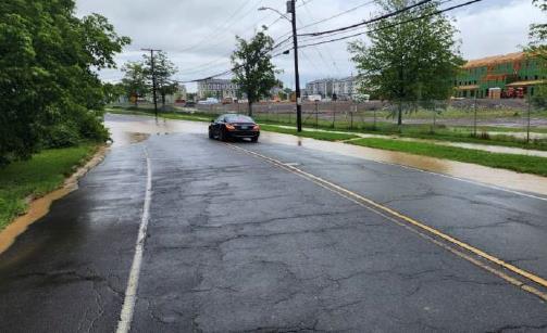


Mark Twain Drive
Granby Street at Nahum Drive
Cornwall Street
61 Woodland Street Parking Lot
3. EXISTING MANAGEMENT MEASURES
Stormwater Management
Sanitary & Combined Sewers Septic Systems
Land Use Controls
Other Climate Resilience Initiatives
EXISTING MANAGEMENT MEASURES
This section summarizes existing management measures – including both structural and non-structural practices – for controlling or reducing nonpoint source pollution and protecting or improving water quality in the North Branch Park River watershed. These include the following measures:
• Stormwater management
• Sanitary and combined sewer overflow abatement
• Septic system management
• Land use regulatory controls
This section also includes a summary of relevant local, state, and regional programs, projects, and initiatives aimed at addressing climate resilience issues that affect the North Branch Park River and its watershed.

Bioretention basin installed at UConn Law School and Hartford InternationalUniversity for Religion and Peace (2014)
Image Source: Fuss & O’Neill

STORMWATER MANAGEMENT
Existing Stormwater System
The watershed municipalities maintain storm drainage systems within the public right-of-way and on municipal properties. Private property owners are responsible for the maintenance of storm drainage systems which serve their properties. In the Town of Bloomfield and the Town of West Hartford, the municipalities are solely responsible for the municipal storm drainage system and associated discharges to local waterbodies and wetlands.
Within the City of Hartford, the Metropolitan District (MDC or District) owns and operates the combined storm and sanitary sewers as well as a number of separated storm sewer systems located within the City. The City of Hartford also owns and operates a number of the separated storm drainage systems. The City and MDC therefore have shared responsibility for the stormwater system in the City of Hartford. The adjacent figure shows the separated storm drainage system (purple) and combined stormwater and sanitary sewer system (green) in the North Branch Park River subwatershed.
MS4 Permit Programs
Stormwater discharges from the separate municipal storm drainage systems in Bloomfield, West Hartford, and Hartford are regulated under the CT DEEP General Permit for the Discharge of Stormwater from Small Municipal Separate Storm Sewer Systems (MS4 Permit or MS4 GeneralPermit). Stormwater discharges associated with state drainage systems are regulated under a similar MS4 Permit issued specifically to the Connecticut Department of Transportation (CT DOT) Both permits establish requirements for implementing Best Management Practices (BMPs) that will reduce pollutant discharges from municipal and state storm drainage systems.
Through their MS4 Permit stormwater management programs and other planning initiatives, the watershed municipalities have developed Stormwater Management Plans and are implementingvarious
BMPs to address stormwater quality issues associated with municipal activities, as well as land development and redevelopment projects.
In the City of Hartford, compliance with the MS4 General Permit is a combined effort between the City of Hartford and the MDC. The City and MDC are working to develop a Memorandum of Understanding that outlines the roles and responsibilities for stormwater management in Hartford. CTDEEP is also in the process of modifying and reissuing the MS4 General Permit and the CTDOT MS4 General Permit.
Green Stormwater Infrastructure
Several green stormwater infrastructure (GSI) and Low Impact Development (LID) practices have been constructed in the North Branch Park River watershed. Demonstration GSI retrofits such as rain gardens and bioretention systems have been installed at several of the schools in the watershed, including parking lots serving the UConn Law School and Hartford International University for Religion and Peace. GSI and LID practices have also been implemented at various public and private redevelopment sites such the phased redevelopment of the former Westbrook Village public housing complex (now called Village at Park River). The watershed municipalities continue to implement GSI and LID retrofits and require similar practices for development and redevelopment projects to comply with their MS4 Permits.


SANITARY & COMBINED SEWERS
Sanitary and Combined Sewer Systems
In the North Branch Park River (NBPR) watershed, the MDC owns and operates a 150-year old combined sewer system in Hartford and portions of West Hartford along the Hartford border, and a 100-year old sanitary sewer system in Bloomfield and West Hartford. The oldest portions of the wastewater collection system were installed during the 19th century, when combined sewer systems were the engineering standard for larger sewage conveyance systems. The adjacent map shows the combined (green) and sanitary (purple) portions of the MDC sewer system (gray shading) in the NBPR subwatershed.
While the combined sewer pipes were originally sized to carry both sewage and stormwater, intense storm events and expansion of the collection system due to development have historically taxed the capacity of the system and the wastewater treatment facility, which cannot handle the large wet weather flows from the combined sewer system. Rain events that fill the pipes beyond their capacity cause sewer overflows, or releases, at various points (i.e., regulators) within the sewer system. These combined sewer overflows (CSOs) can cause raw sewage to back up into basements, yards, and streets, as well as discharge directly to the NBPR.
North Branch Park River CSOs
The adjacent map shows the locations of four outfalls where untreated wastewater can discharge directly to the NBPR during CSO events. These four outfalls are associated with CSO regulators N-2 and N-4 in the Granby Street area, and N-9 and N-10 in the Farmington Avenue area. Several other CSO outfalls discharge to the underground portion of the NBPR within the conduit.
Portions of the separate sanitary sewer systems in Hartford, Bloomfield, and West Hartford also have significant rehabilitation needs. Excessive inflow and infiltration (I/I) from pipe deficiencies and illicit private connections are an ongoing problem that limits capacity in the sanitary sewer system, causing sanitary sewer
overflows (SSOs) and further contributing to CSOs.
Integrated Long-Term CSO Control Plan
The MDC is implementinga multi-billion Clean Water Project (CWP) to control or eliminate CSOs and SSOs in accordance with a federal Consent Decree and a state Consent Order. The CWP components are set forth in a CTDEEP approved document known as the “Long-Term CSO Control Plan” (CSO LTCP). The 2018update of the CSO LTCP followed EPA’s Integrated Planning Framework, which is a more holistic, cost-effective approach to address multiple objectives.
The 2018Integrated CSO LTCP took a new approach for the Northern Hartford area CSOs differing from that in the 2012/2014CSO LTCP Update. The previous plan proposed a deep rock tunnel storage system for CSO mitigation. The 2018evaluation showed that sewer separation can provide significant and cost-effective CSO reduction in the North Branch District, including the Granby and Blue Hills area.
The 2018Integrated CSO LTCP for the Granby Street area includes a combination of sewer separation, I/I reduction, Homestead Avenue improvements, and regulator modifications. The proposed Granby Area sewer separation project will result in up to three new, large separated stormwater outfalls to the North Branch Park River between Albany Avenue and the University of Hartford. For the Farmington Avenue area CSOs, the 2018Integrated Plan and subsequent design refinements include replacement of the existing New North Branch Interceptor (NNBI) with a new, larger interceptor on the east side of the river and other system upgrades. Collectively, these improvements will eliminate the four CSO regulators and discharges to the aboveground portion of the North Branch Park River (N-2, N-4, N-9, and N-10). The remaining Farmington Area CSO regulators that discharge to the Park River conduit will be controlled to the 1-year design storm.
The MDC is scheduled to re-evaluate and update the Integrated CSO LTCP in 2028.
SEPTIC SYSTEMS
Septic System Management
Although most of the North Branch Park River watershed is served by sanitary or combined sewers, portions of the western and northern sections of Bloomfield are on privately-owned on-site sewage disposal systems, also commonly called septic systems. Septic systems are prevalent in the residential headwater areas of the Wash Brook and Tumble Brook subwatersheds. The adjacent map shows areas served by sanitary or combined sewers and areas served by septic systems.
Septic systems that are properly designed, installed, and maintained provide a safe and efficient way of disposing domestic sewage. Failing or older, sub-standard systems can impact surface water and groundwater quality and can expose the public to untreated sewage and be a source of bacteria, pathogens, and nutrients to the North Branch Park River and other surface waterbodies.
The adjacent map also shows general soil suitability ratings for subsurface sewage disposal based on NRCS soil survey information. Soils with Extremely Low (red), Very Low (orange), and Low (yellow) potential for subsurface sewage disposal systems in unsewered areas are potential locations where older systems may be prone to failure or sub-standard performance.
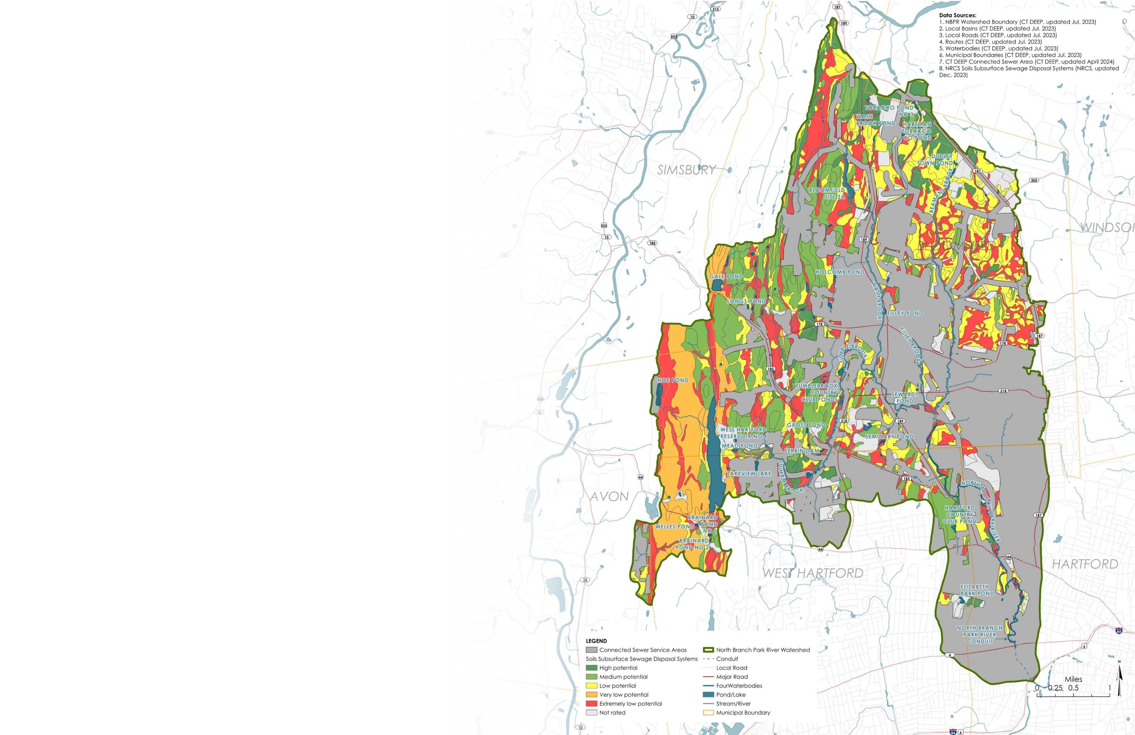
Septic systems on sites with design flows of 7,500 gallons per day (GPD) and less are under the jurisdiction of the Connecticut Department of Public Health (CT DPH) and the Local Directors of Health. The Town of Bloomfield is part of the West Hartford-Bloomfield Health District, which has jurisdiction over septic systems for compliance with the CT Public Health Code. This includes site investigation, design approval, permit issuance, and other necessary inspections. Plans for large septic systems serving buildings with design flows of 2,000to 7,500GPD must be approved by CT DPH.
Maintenance, repair, and replacement of septic systems is the responsibility of the property owner. Facilities with larger new or existing systems (>7,500GPD) are required to obtain a CT DEEP permit, which requires oversight and maintenance of the system by the facility owner.
LAND USE CONTROLS
Municipal land use plans, policies, and regulations help shape the development patterns within a watershed and can play a significant role in protecting water quality at the watershed scale. These commonly include municipal plans of conservation and development, zoning regulations, subdivision regulations, inland wetland and watercourses regulations, and stormwater regulations, all of which influence the type and density of development that can occur within a watershed.
The 2010North Branch Park River Watershed Management Plan included a review of municipal land use plans, policies, and regulations for the watershed communities, with a focus on Bloomfield, West Hartford, and Hartford. The review also identified opportunities and recommendations to better protect water resources through new or modified regulatory mechanisms.
The scope of this watershed management plan update does not include a detailed update of the 2010regulatory review or land use regulatory recommendations. Instead, this section summarizes some of the current land use plans, policies, and regulations for Bloomfield, West Hartford, and Hartford and other entities with a land use regulatory or planning role in the North Branch Park River watershed.
Town of Bloomfield
• Bloomfield Community Vision & Plan of Conservation and Development (ongoing)
• Complete Streets Master Plan and Complete Streets Policy (2021)
• Bloomfield Zoning Regulations (adopted 2009,amended through April 2024)
• Trees for Bloomfield Initiative, Bloomfield Beautification Committee and Bloomfield Conservation, Energy and Environment Committee
Town of West Hartford
• West Hartford Plan of Conservation and Development (2020-2030)
• Town of West Hartford Complete Streets Policy (2015)
• West Hartford Zoning Regulations revisions (2018)
▪ Stormwater management
City
of
Hartford
• City of Hartford Zoning revisions (2016)
▪ Form based approach requiring more compact development
▪ Institutes 25 to 50 foot “development-free” buffers near waterways
▪ Prioritizes low-impact development and green infrastructure
▪ Limits impervious coverage (and thus stormwater runoff) on every lot
• City of Hartford Zoning revisions (2023)
▪ Green Infrastructure Fund provisions
• Hartford City Plan (Hartford 2035Plan) (2020)
• Hartford Tree Canopy Action Plan (2020)
• City of Hartford Complete Streets Plan (2020)
• Hartford: Green Infrastructure for a More Resilient and Sustainable Future (2018)
• Green Infrastructure Handbook, Best Management Practices in Hartford, Connecticut (2018)
• City of Hartford Climate Action Plan (2017)
• Asylum Hill Strategic Plan, 2022-2031(2022) and Neighborhood Plan (ongoing)
• Upper Albany Neighborhood Plan (2023)
• City of Hartford ComprehensiveParking Study (2022)
Greater Hartford Flood Commission
• Rules and Regulations Governing the Use of the Flood Plain District (Adopted 2008, amended 2011)
Capitol Region Council of Governments (CRCOG)
• Regional Stormwater Authority Feasibility Study (beginning in 2025)
• Hazard Mitigation & Climate Adaptation Plan (2024)
• ACT Greater Hartford – A Comprehensive Economic Development Strategy for Growth and Equity in the Capitol Region (2023)
• Metro Hartford Brownfields Assessment and Revolving Loan Fund Program
• Capital Region East Coast Greenway Study (2023)
• Regional Climate Action Plan (ongoing)
• Sustainable Land Use Code Project, Model Land Use Regulations (2014)
Other
• The Hartline Trail, Hartford 400 and The iQuilt Partnership


OTHER CLIMATE RESILIENCE INITIATIVES
Various local, state, regional, and federal organizations are involved in ongoing and/or upcoming programs, projects, and initiatives aimed at addressing climate resilience issues that affect the North Branch Park River and its watershed. Many of these climate resilience activities are directly related to or aligned with the goals and objectives of this watershed planning process including water quality, green infrastructure, flooding, and community resilience. This section highlightsseveral of these efforts as they relate to the North Branch Park River watershed plan update and the planning recommendations that are presented in Section 4.
North Branch Park River Drainage Study and Blue Hills/Granby Area Sewer Separation Design
The MDC and City of Hartford, with additional funding from CTDEEP, are conducting an evaluation of flooding in the Blue Hills/Granby Street area. The project also includes an update of the sewer separation conceptual design in the Blue Hills Avenue/Granby Street area to a preliminary design level for the MDC to determine the scope and magnitude of separated stormwater infrastructure necessary to eliminate combined sewer overflows (CSOs) from the project area. An evaluation of the North Branch Park River from the University of Hartford campus to the Park River Conduit entrance has been completed, and the sewer separation preliminary design is in progress. Draft reports on both aspects of the project are anticipated to be released in 2025.
Granby Street Green Infrastructure Demonstration Project
The City of Hartford, in collaboration with the MDC, is working with EPA Region 1 and contractors with the University of New Hampshire Stormwater Center on a demonstration project to pilot the use of subsurface stormwater infiltration trenches within the municipal right-of-way in the Granby Street area. Subsurface infiltration trenches are retrofits of existing catch basins designed to infiltrate runoff from small storms. If successful, these systems could potentially be applied on a larger scale across the City to reduce stormwater pollutant loads and runoff volumes.
Hartford NEXT Stakeholder Engagement and Green Stormwater Infrastructure Project
Hartford NEXT, a coalition of Hartford’s Neighborhood Revitalization Zones and the City of Hartford), received grant funding through EPA and CTDEEP to conduct stakeholder engagement and implement green stormwater infrastructure in Hartford’s North End.
Blue Hills Civic Association and Connecticut Green Bank Green Infrastructure and Resilience Partnership
The Connecticut Green Bank, together with Blue Hills Civic Association and other community partners and stakeholders, have received private foundation funding to focus on opportunities to invest in equitable and climate resilient water infrastructure in Hartford. The Green Bank aims to increase stormwater management through both natural (i.e., parks) and built (i.e., homes) infrastructure solutions, to help revitalize Hartford’s parks as public health infrastructure, and to empower residents to access green solutions to increase their climate preparedness and resilience. The project and partnership will empower homeowners in the North End and to enable stormwater solutions for increased climate resilience.
Capital Region Council of Governments Regional Stormwater Authority Feasibility Study
The Capitol Region Council of Governments (CRCOG) has been awarded a CT DEEP Climate Resilience Fund grant to support developing a stormwater authority feasibility study in the CRCOG region. This study will examine the viability of implementing a regional stormwater utility in approximately eight municipalities within the region. A stormwater utility is a fee-based system that could provide a dedicated source of source of income to help finance and maintain stormwater infrastructure.
Capital Region Council of Governments Natural Hazard Mitigation & Climate Adaptation Plan
CRCOG recently completed its 2024update to the regional multi-jurisdictional hazard mitigation plan for the Capitol Region, including the communities in the North Branch Park River watershed. Completed with the help of the UConn Connecticut Institute for Resilience and Climate Adaptation (CIRCA) through the Resilient Connecticut program, the Natural Hazard Mitigation and Climate Adaptation Plan (HMCAP) incorporates climate change impacts (flooding, extreme heat, etc.) into the hazard mitigation planning process and strategy development for the region’s communities. The HMCAP promotes the use of green infrastructure and recommends undertaking a flood mitigation study for the North Branch Park River that identifies potential acquisitions and green infrastructure projects that will reduce flooding and flood damage and that provide other co-benefits such as habitat enhancement.
CTDEEP Climate Resilience Fund Grant Program
CTDEEP is in the process of expanding its DEEP Climate Resilience Fund (DCRF) grant program to better enable communities to access federal funding for climate resilience. This upcoming investment of state funds will help towns, Councils of Government, and other stakeholders pursue project planning, and in some cases construction, allowing them to tap into the billions of federal dollars available to improve local resilience. The expanded framework will add a new DCRF funding category for deployment to give eligible applicants state and federal funding to build resilience projects such as stormwater parks, resilience hubs that serve as cooling and warming centers, microgrids and clean backup power and storage, and establishing stormwater authorities. CTDEEP is also considering a new Climate Resiliency Revolving Loan fund that the Legislature recently authorized. The expanded DCRF program will be overseen by the new CTDEEP Office of Planning and Resilience.
Hartford USDA Urban and Community Forestry Grant - Capital Forest Stewardship Initiative
The City of Hartford received $6 million from the USDA Forest Service’s Urban and Community Forestry Grant program, which will be used to implement the Capital Forest Stewardship Initiative. The City is using the funding to address the health and vitality of its urban canopy in both public and private spaces. The grant supports the City’s sustainability goals of 35% tree cover by 2070. With climate change exacerbating the urban heat island effect, increasing canopy coverage can allow direct sunlight and heat to be absorbed and diffused. As part of the Capital Forest Stewardship Initiative, the City will use a holistic approach to plant and support the growth of new trees, maintain mature trees through compost and tree trimming cycles, assess and remove trees that could pose public hazards, and for community education, outreach, and engagement.
4. WATERSHED MANAGEMENT RECOMMENDATIONS
Watershed Management Plan Goals and Objectives
Capacity and Plan Implementation
Water Quality Land Conservation
Habitat Restoration
Sustainable Development and Land Use
Climate and Community Resilience Education and Stewardship
WATERSHED MANAGEMENT PLAN GOALS AND OBJECTIVES
This watershed management plan has seven overarching goals (below) and related objectives (right). This section includes recommended management strategies and specific actions to achieve the plan goals and objectives, along with suggested partners, measurable milestones, anticipated timeframes, potential funding sources (see Section 7 and Appendix C for more details on funding sources), and relative costs. Recommended actions include actions that can be implemented throughout the North Branch Park River watershed as well as site- or area-specific projects and actions to address issues at specific sites, neighborhoods, or subwatersheds.
This plan is a guidance document that seeks to address water quality and related issues within the North Branch Park River watershed. Unless identified as a required action under an existing permit, the recommendations in this plan are intended to be voluntary undertakings, carried out with willing, cooperative partners, working together to protect and improve water quality. This plan identifies potential partners and funding sources to assist with implementing the plan recommendations, which should be updated every 10+ years.
Plan Goals
• Capacity and Plan Implementation: Strengthen local and regional capacity to implement the watershed management plan by building on the existing network and programsof organizations, volunteers, watershed municipalities,institutions, residents, and other stakeholders.
• Water Quality: Improve water quality in the impaired segments of the North Branch Park River to meet state water quality standards such that it supports its designated uses, as well as maintain and enhance water quality of its tributaries. Water quality is essential to the economic well-being, environmental and public health, recreational opportunities, and quality of life for the residents, local governments, and visitors of the North Branch Park River watershed.
• Land Conservation: Protect or preserve land in a natural or undeveloped state through acquisition and/or conservation easement or other type of conservation restriction. Target existing undeveloped parcels along riparian corridors and in headwater areas, as well as areas proposed for riparian and floodplain restoration.
• Habitat Restoration: Restore and enhance instream and riparian habitat, wetlands, and terrestrial wildlife habitat including forested areas and tree canopy.
• Sustainable Development and Land Use: Promote balanced, sustainable growth, economic development, and cultural vitality, without adversely impacting the watershed and by preserving and enhancing the watershed’s natural resources for future generations.
• Climate and Community Resilience: Increase the infrastructure, ecological, and social/community resilience of the North Branch Park River watershed to climate change impacts including flooding, extreme heat, drought, and related water quality impacts.
• Education and Stewardship: Educate citizens about the North Branch Park River watershed and the human and economic benefits of a healthy watershed. Involve the nine K-12 schools, three universities, and four cultural heritage sites located along the five-mile North Branch mainstem in learning activities and stewardship. Increase citizen stewardship by expanding community involvement in scientific research, history and arts cultural programmingand urban ecological conservation. Connecting people to local landscapes inspires a sense of appreciation, which is needed to establish sustainable environmental stewardship practices.
Plan Objectives
Capacity and Plan Implementation
A. Watershed Organization. Establish a new organization focused upon stewardship of the North Branch, or modify the existing 501c3, Park Watershed, to more effectively implement the updated watershed management plan.
B. Collaboration. Increase collaboration among related stakeholder organizations and property owners along the North Branch.
C. Funding. Secure funding for plan implementation, including sustained support for dedicated staff.
Water Quality
A. Combined Sewer Overflows. Eliminate the remaining CSO discharges to the North Branch Park River.
B. Green Infrastructureand Low Impact Development. Minimize and manage stormwater runoff using green infrastructure and low impact development strategies. Provide volume management, peak flow reduction, and water quality improvementsat permitted discharge outfalls, as feasible.
C. Illicit Dischargesand Septic Systems. Improve water quality by identifying and eliminating illicit discharges.
D. Monitoring. Continue to implement regular water quality and biologicalmonitoring to refine an understanding of pollutant sources, inform decision-making, and measure progress toward meeting water quality goals.
E. Field Assessments. Conduct additional field assessments in upstream NBPR tributaries and subwatersheds.
Land Conservation
A. Land Conservation - Upstream Tributaries. Conserve land in upstream tributary subwatersheds.
B. Land Conservation - North Branch Park River Floodplain and Riparian Areas. Conserve land in floodplain/riparian areas.
C. Open Space Protection Program Capacity. Strengthen capacity and coordination of open space protection programs in the watershed.
Habitat Restoration
A. Riparian Restoration. Restore developed land within riparian areas and floodplains to a natural undeveloped condition.
B. Forests and Urban Tree Canopy. Protect and enhance forested areas and urban tree canopy
within the watershed and restore understory vegetation.
C. Invasive Species Control. Control or diminish the prevalence of invasive species.
D. Stream Cleanups. Conduct stream cleanups along riparian areas.
Sustainable Development and Land Use
A. Urban Landscape Design. Develop a process of large-scale restoration along the North Branch mainstem. Diagram a gradient from the dynamic northern riparian area to low maintenance features that provide safe public access and scenic vistas of the North Branch.
B. Smart Growth. Balance economic development and resource conservation through smart growth principles. Utilize CRCOG Regional Plan of Conservation & Development.
C. Public Access. Increase public access to the North Branch Park River and its tributaries to enhance public appreciation and stewardship of the river.
Climate and Community Resilience
A. Riverine Flooding and Flood Management. Increase resilience to riverine flooding along the NBPR and its tributaries through natural channel design (river restoration) and floodplain restoration/management.
B. Stormwater Flooding and Impervious Surface Mitigation. Increase resilience to stormwater flooding and extreme heat through drainage improvements, green stormwater infrastructure, and impervious surface reduction.
Education and Stewardship
A. Youth and Students. Increase K-12 community service; establish a regional symposium for academic research for higher education.
B. Campus and Institutional Properties. Present watershed plan to property managers and campus planners.
C. Residents and Homeowners. Provide printed literature and experiential environmental education programming.
D. Municipal Staff and Volunteer Commissions. Arrange environmental best practices demonstrations at municipal and golf courses, parks and cemeteries.
E. Businesses and Commercial Landowners. Present best practices for runoff pollution reduction and benefits of green infrastructure.
CAPACITY AND PLAN IMPLEMENTATION
Goal Statement:
Strengthen local and regional capacity to implement the watershed management plan by building on the existing network and programs of organizations, volunteers, watershed municipalities, institutions, residents, and other stakeholders.
The Issue
The success of any watershed management plan depends on effective leadership, active participation of stakeholders, and local “buy-in” to leverage change as outlined in this Plan. Support by well-established organizations and government agencies, ongoing funding, and technical assistance is critical. Currently, there is no land trust operating in the city and land protection has not been utilized by the municipal leadership. Engagement of local and regional land trusts, including a partnership with TPL and Traprock Land Conservancy, will be crucial to implement the recommendations of the plan.
Connecticut's first "urban" watershed management plan, the original 2010 North Branch Park River Watershed Plan has provided guidance for project implementation and has prompted the formation of Park Watershed, a 501c3 nonprofit stewardship organization in 2012. Fortunately, community involvement throughout the recent watershed planning process has demonstrated significant local support and “capacity” to advance implementation of the 2025 Plan. Park Watershed has expanded public awareness through educational partnerships with local schools, North Central Conservation District, and other nonprofits, most notably, the West End Civic Association and Asylum Hill Neighborhood Association. Strengthening local and regional capacity for implementing the updated 2025 Plan by building on the existing network of volunteers and programs is a critical and ongoing part of the watershed plan implementation process.
Strategies
The following strategies are recommended to strengthen local and regional capacity to implement this watershed management plan. The table on the following page outlines specific actions related to each strategy.
Watershed Organization
Despite the success of Park Watershed and its partners in implementing many of the recommendations of the 2010 North Branch Park River Watershed Management Plan, establishing a new or modified watershed organization is recommended to more effectively implement the updated plan:
❑ Form a North Branch Task Force which can be modeled after other successful watershed committees such as the Niantic River Watershed Committee. Involve stakeholders that can collaboratively lead and coordinate implementation activities of the updated watershed management plan.
❑ Continue to seek funding for and support a paid “watershed coordinator”
position through the NCCD or CRCOG.
❑ Secure funding and issue a Request for Proposals for an interdisciplinary landscape and urban design study that includes economic development, neighborhood mobility, and risk analysis of property relationships to North Branch riparian areas (including surveys and title searches).
Collaboration
Increased collaboration between the watershed municipalities, MDC, CRCOG, CTDEEP, and other organizations is needed to implement the plan recommendations.
❑ Obtain endorsement of the plan by the Project Partners to better support plan implementation efforts. Encourage inter-municipal coordination to support implementation of the plan. In May 2023, Hartford City Council approved a Resolution that supports conservation and restoration of the North Branch could serve as a model.
❑ Hold quarterly meetings of the North Branch Task Force to assess the progress of the watershed management plan implementation.
❑ Form a watershed agreement, municipal compact, or similar mechanism between municipal leaders in Hartford, West Hartford, and Bloomfield, the MDC, and CRCOG. Such an endorsement would encourage inter-municipal coordination and formalize a commitment to support implementation of the plan through funding, staff, or other resources.
Funding
Many actions in this plan are only achievable with sufficient funding and staffing. A variety of funding opportunities should be pursued to implement the recommendations outlined in this plan.
❑ Review and prioritize potential funding sources that have been preliminarily identified in this plan including grants and dedicated funding such as stormwater authorities. Refer to Appendix C for more information on potential funding sources.
❑ Prepare and submit grant applications for projects identified in this plan on an ongoing basis. Task to be led by the North Park Task Force watershed coordinator.
❑ Advocate for state and federal funding, working jointly with other watershed organizations in the region and state.

CAPACITY AND PLAN IMPLEMENTATION (CONTINUED)
A. Watershed Organization
Establish a new or modify the existing watershed organizationto more effectively implement the updatedwatershed management plan
1. Form a North Branch Task Force. Include Park Watershed and representativesof the watershedmunicipalities, MDC, North Central ConservationDistrict, CRCOG, institutionalproperty owners, Northside InstitutionsNeighborhood Alliance (NINA), adjacent Neighborhood RevitalizationZones(NRZs), and Park Watershed to collaborativelylead and coordinate implementationactivities of the updatedplan.
2. Continueto seek funding for and supporta paid “watershed coordinator”position throughthe NorthCentralConservation District(modeled after the successfulNiantic River Watershed Coordinatorthroughthe Eastern ConnecticutConservationDistrict) or another stakeholderentitysuch as Park Watershed.
3. Secure funding and issue a Requestfor Proposals for an interdisciplinary landscapeand urban designstudy that includes economic development, neighborhoodmobility, and risk analysis of property relationshipsto NorthBranchriparian areas (including surveysand title searches).
B. Collaboration Increase organizational collaboration
1. Obtainendorsementof the Plan by the Project Partnersthrough the new North BranchTask Force to better supportplan implementationefforts.Task Force to meet annualwith elected officialsof municipality.
2. Hold quarterlymeetingsof the North Branch Task Force to assess the progressof the watershedmanagement plan implementation.
3. Work with local, regional, and statewideorganizations to implement efforts,and to clarify what legal agreements and financialincentivesare needed for institutionalproperty ownersto support conservationand restorationof floodplains.Review innovative conservationcompacts and financingoptions.
C. Funding Identifyand secure funding
1. Review and prioritize potentialfunding sources that have been preliminarily identifiedin this Plan includinggrants and dedicated fundingmechanismssuch as stormwaterutilities.
North Branch mainstem Park Watershed,NB municipalities(WH, (Hartford, Bloomfield)MDC, NCCD, CROG, adjacentNRZs (AHNA, WECA, UA, BHCA), NINA & property owners. • Formationof a North BranchTask Force • Developmentof an organizationalchart to clarify responsibilities
WATER QUALITY
Goal
Statement: Improve water quality in the impaired segments of the North Branch Park River to meet state water quality standards such that it supports its designated uses, as well as maintain and enhance water quality of its tributaries. Water quality is essential to the economic well-being, environmental and public health, recreational opportunities, and quality of life for the residents, local governments, and visitors of the North Branch Park River watershed.
The Issue
The water quality of the North Branch Park River has been degraded due to extensive urbanization within its watershed. The North Branch Park River is considered impaired for recreation (due to elevated levels of the fecal indicator bacteria E. coli) and habitat. Sources of fecal indicator bacteria in the North Branch Park River watershed include stormwater discharges from municipal separate systems and permitted facilities, potential illicit discharges and failing or malfunctioning septic systems, combined sewer overflows (CSOs) in the lower part of the river, pet waste, waterfowl, agricultural activity, and other natural sources such as wildlife. The extensive channelization, urbanization of the river corridor, and numerous stormwater and CSO outfalls have contributed to stream bank and channel erosion and sediment deposition, which also impacts the river’s water quality.
Strategies
The following strategies are recommended to improve and protect water quality. The tables on the following pages outline specific actions related to each strategy.
Combined Sewer Overflows
Through its Integrated CSO Long-Term Control Plan (LTCP), the Metropolitan District (MDC) is implementing infrastructure improvementsthat will ultimately eliminate the four CSO regulators and discharges to the aboveground portion of the North Branch Park River, which is a substantial source of bacteria and other pollutants to the lower portion of the river.
❑ Continue to update and implement the MDC Integrated CSO Long Term Control Plan. The next update of the Integrated CSO LTCP is due in 2028. MDC anticipates beginning drafting the next plan update in late 2026or early 2027.
❑ Evaluate and incorporate green stormwater infrastructure (GSI) as part of the Integrated CSO LTCP update in combination with sewer separation and other traditional hard infrastructure solutions. For example, incorporate GSI within the North End neighborhoodswhere sewer separation is proposed (see Green Infrastructure and Low Impact Development strategies and actions).
Green Infrastructure and Low Impact Development
The use of Green Infrastructure and Low Impact Development to more effectively manage stormwater runoff and provide numerous co-benefits is a major objective and strategy of this updated watershed management plan. As demonstrated by the location specific green infrastructure designs presented in Section 5 numerous opportunities exist to retrofit existing impervious surfaces with bioswales, rain gardens, infiltration systems, green roofs, and other green stormwater infrastructure(GSI) practices on public and institutional properties within the watershed including parking lots, schoolyards, and along roads (green streets).
Opportunities also exist for installation of larger subsurface storage and infiltration systems below athletic fields and parking lots.
Several areas of the watershed with combined sewers are slated for future sewer separation (e.g., Granby Street and Blue Hills neighborhood), creating the opportunity to incorporate GSI within the public right-of-way, on public and institutional properties, on residential properties, and through off-line water quality treatment systems (e.g., stormwater parks) for new separated stormwater outfalls. Other key green infrastructure recommendations include:
❑ Incorporate GSI/LID into municipal infrastructureprojects including capital improvementsfor municipalfacilities and roadway projects (e.g., complete streets, streetscape, road widening).

North Branch Park River during October 2023flood event Image Source: Mary Rickel Pelletier
WATER QUALITY (CONTINUED)
Green Infrastructure and Low Impact Development (Continued)
❑ Resolve the issue of shared stormwater responsibility between the City of Hartford and the MDC.
❑ Involve all NB municipalities (Bloomfield, West Hartford and Hartford) CRCOG, Park Watershed and land trust nonprofits in GSI planningand conservation of NB tributary riparian areas.
❑ Implement recommendations of the ongoing CRCOG RegionalStormwater Authority Feasibility Study
❑ Implement recommendations of the ongoing University of New Hampshire Stormwater Center and City of Hartford infiltration trench pilot project.
❑ Implement trainingfor public works staff on maintenance of GSI practices.
❑ StrengthenGSI/LID and flood resilience requirements in municipal land use regulations to satisfy MS4 Permit regulatory requirements for new development and redevelopment, address flooding and resilience issues, and incentivize reduction in impervious areas on private property.
❑ Implement green infrastructure at public and private schools in the watershed through GSI retrofits and restoration of the developed riparian corridor (i.e., conversion of impervious surfaces to natural riparian and floodplain areas).
❑ Prioritize sustainable design and reuse options in brownfields redevelopment, consistent with CRCOG’s regional POCD.
Illicit Discharges and Septic Systems
Illicit discharges(non-stormwater flows that discharge into the storm drainage system or directly into surface waters), including failing or older, sub-standard septic systems in unsewered areas of the watershed are a source of bacteria, pathogens, and nutrients to the North Branch Park River and other surface waterbodies. An objective of the plan is to improve water quality by identifying and eliminating illicit discharges in the upstream communities of Bloomfield and West Hartford and in the City of Hartford.
❑ Explore the feasibility of expanding sewer service in areas of Bloomfield that are served by outdated subsurface sewage disposal systems and have soils with poor infiltration capacity. Ensure consistency with land use planning and conservation/development objectives.
❑ Promote regular maintenance of septic systems by providing homeowners with educational materials and programs. Explore options for group discounts to homeowners to pump and repair septic systems.
❑ Inventory and map the larger, State-regulated subsurface sewage disposal systems in the watershed, and identify highpriority systems for ongoing oversight based on consideration of system size, soils, proximity to waterbodies, and performance history.
❑ Ensure that the watershed municipalities are implementing Illicit DischargeDetection and Elimination (IDDE) programs consistent with the MS4 General Permit.
Monitoring and Field Assessments
Regular water quality and biological monitoring within the North Branch Park River watershed is recommended to refine an understanding of pollutant sources, inform decision-making, and measure progress toward meeting water quality goals. Additional field assessments are also recommended in upstream tributaries and subwatersheds as the focus of the 2025plan update was on the NBPR subwatershed.
❑ Implement water quality monitoring (fecal indicator bacteria and other chemical parameters) at locations along the NBPR mainstem and upstream tributaries (Wash Brook, Tumble Brook, Filley Brook, and Beamans Brook), building on previous monitoring by Trinity College, St. Joseph College, and others.
❑ Consider conductingbenthic microorganismsurveys to monitor ongoing progress in water quality improvement.
❑ Conduct streamwalk assessments and track down surveys within upstream NBPR tributaries and subwatersheds
❑ Prepare and implement subwatershed action plans for upstream NBPR tributaries and subwatersheds based on the findings of water quality monitoring, streamwalk assessments, and track down surveys.
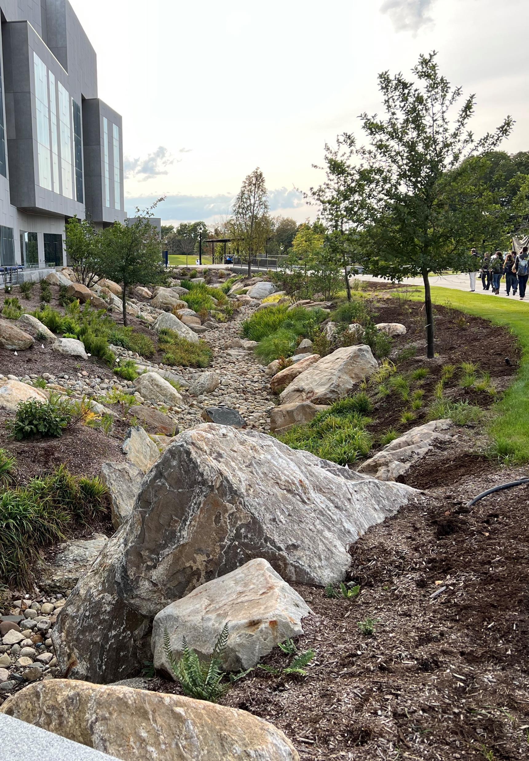
WATER QUALITY (CONTINUED)
A. Combined Sewer Overflows
Eliminate the remaining CSO discharges to the North Branch Park River.
1. Continue to update and implement the MDC Integrated CSO Long Term Control Plan (LTCP). Next update of the Integrated CSO LTCP is due in 2028.MDC anticipates beginning drafting the next plan update in late 2026or early 2027.
2. Evaluate and incorporate GSI as part of the LTCP/IP update in combination with sewer separation and other traditional hard infrastructure solutions (see Water Quality Objective B and associated actions).
North Branch mainstem MDC, CT DEEP, US EPA, City of Hartford
B. Green Infrastructure and Low Impact Development
Better manage stormwater runoff using Green Infrastructure and Low Impact Development strategies.
North Branch mainstem MDC, CT DEEP, US EPA, City of Hartford, North Park Task Force, Park Watershed
1. In conjunction with separation of combined sanitary/storm sewers in the watershed (Granby Street/Blue Hills and other areas), implement green stormwater infrastructure (GSI) for the new separate storm drainage systems to capture and treat stormwater runoff prior to discharge to the NBPR: 1) small-scale GSI practices within the municipal right-of-way (i.e., green streets), and 2) off-line, end-of-pipe GSI measures such as stormwater pond/wetland systems, which can also serve as stormwater parks, or other large-scale GSI such as subsurface storage systems below athletic fields and parking lots. North Branch mainstem MDC, City of Hartford, North Park Task Force, Greater Hartford Flood Commission
2. Implement GSI on parcels within the drainage area of new separate storm drainage systems: 1) retrofits and redevelopment of public and private institutional properties, and 2) low Impact development practices on residential properties.
3. Pursue fundingfor and implement site-specific stormwater retrofit concepts identified in this Plan.
North Branch mainstem Property owners (watershed municipalities,public and private institutional property owners, homeowners)
North Branch mainstem North Park Task Force, NCCD, Hartford, West Hartford, Bloomfield
4. Incorporate GSI/LID into municipal infrastructure projects including capital improvementsfor municipalfacilities and roadway projects (e.g., complete streets, streetscape, road widening). Prioritize stormwater infrastructure improvements that address water quality, flooding, extreme heat, and equity. All Hartford, NRZs, West Hartford, Bloomfield
5. Resolve the issue of shared
and the MDC.
Funding obtained
Projects designed and constructed
• Retrofit plans completed
• Projects identified • Funding obtained • Projects designed and constructed
• Framework and action plan to evaluate and implement stormwater infrastructure financing
• Projects identified • Funding obtained •
WATER QUALITY (CONTINUED)
B. Green Infrastructure and Low Impact Development
Better manage stormwater runoff using Green Infrastructure and Low Impact Development strategies.
6. Involve all NB municipalities (Bloomfield, West Hartford and Hartford) CRCOG, Park Watershed and land trust nonprofits in GSI planning and conservation of North Branch riparian areas. Also refer to Land Conservation Section.
7. Implement recommendations of the ongoing CRCOG Regional Stormwater Authority Feasibility Study, potentially including establishment of stormwater authorities by the watershed municipalities or a regional stormwater authority.
8. Implement recommendations of the ongoing University of New Hampshire Stormwater Center and City of Hartford pilot project demonstratingthe feasibility and effectiveness of implementingsubsurface infiltration trenches at-scale throughout the City. If successful, educate others in the region on how to deploy elsewhere.
9. Provide trainingfor public works staff and contractors on inspection and maintenance of green stormwater infrastructure (GSI) practices. See recommendations in Education and Stewardship section.
10. StrengthenGSI/LID and flood resilience requirements in municipal land use regulations to satisfy or exceed MS4 Permit minimum regulatory requirements for new development and redevelopment, address flooding and resilience issues, and incentivize reduction in impervious areas on private property. At a minimum, review and update municipal land use regulations to reflect current stormwater management standards and design guidelines for new development and redevelopment projects, including the 2024Connecticut Stormwater Quality Manual and the post-construction stormwater management requirements in the CTDEEP MS4 General Permit.
11. Implement green infrastructure at public and private schools in the watershed through GSI retrofits and restoration of the developed riparian corridor (i.e., conversion of impervious surfaces to natural riparian and floodplain areas). Integrate GSI with educational programming,climate resilience, and community cohesion modeled after the TPL Green/Community Schoolyard program.
All Bloomfield, West Hartford and Hartford Conservation Commissions,CRCOG, and Park Watershed • Conservation of upstream riparian zones & wetlands
All CRCOG, MDC, Hartford, West Hartford, Bloomfield
All Hartford, West Hartford, Bloomfield
to appraise unprotected riparian areas
WATER QUALITY (CONTINUED)
B. Green Infrastructure and Low Impact Development
Better manage stormwater runoff using Green Infrastructure and Low Impact Development strategies.
12. Implement green infrastructure at campuses and large institutional properties in the watershed through GSI retrofits and restoration of the developed riparian corridor (i.e., conversion of impervious surfaces to natural riparian and floodplain areas). Incorporate green infrastructure into the master planning process and campus redevelopment projects for higher-ed campuses in the watershed.
13. Consistent with the recently adopted CRCOG 2024Plan of Conservation and Development, prioritize sustainable design and reuse options in brownfields redevelopment. As brownfields in the watershed are redeveloped, incorporate green infrastructure techniques into the site redevelopment including GSI, open space, community gardens, pocket parks, and microforests, as appropriate.
C. Illicit Discharges
Improve water quality by identifying and eliminating illicit discharges.
1. Explore the feasibility of expanding sewer service in areas of Bloomfield that are served by outdated subsurface sewage disposal systems, have soils with poor infiltration capacity, and are consistent with land use planning and conservation/development objectives.
All UConn Law School, Hartford International University for Religion and Peace, University of Hartford, Trinity Health Systems/St. Francis Hospital, etc.
Hartford, West Hartford, Bloomfield, North Park Task Force
Filley Brook, Beamans Brook, Wash Brook, and Tumble Brook subwatersheds MDC, West HartfordBloomfield Health District, Park Watershed
• Retrofit plans completed
• Projects identified
• Funding obtained • Projects designed and constructed
2. Promote regular maintenance of septic systems by providing homeowners with educational materials and programs on how to identify malfunctioning systems and procedures to inspect, clean, and repair or upgrade septic systems. Explore options for group discounts to homeowners to pump and repair septic systems.
3. Inventory and map the larger, State-regulated subsurface sewage disposal systems in the watershed. Coordinate with CT DPH and/or CT DEEP to review records related to system performance and corrective actions taken to resolve prior performance issues. Identify high-priority systems for ongoing oversight based on consideration of system size, soils, proximity to waterbodies, and performance history.
4. Ensure that the watershed municipalities are implementing Illicit DischargeDetection and Elimination (IDDE) programs within the NBPR watershed consistent with the MS4 General Permit including dry weather outfall screening, catchment investigations, and illicit discharge removal.
Filley Brook, Beamans Brook, Wash Brook, and Tumble Brook subwatersheds
West HartfordBloomfield Health District, homeowners
Filley Brook, Beamans Brook, Wash Brook, and Tumble Brook subwatersheds West HartfordBloomfield Health District
Identification of areas served by outdated systems
Participation in discussions with responsible entities
materials distributed to homeowners
• List of highpriority systems for ongoing oversight
All Hartford, West Hartford, Bloomfield
• Compliance with permit deadlines for mapping, outfall monitoring, regulatory updates, etc.
Municipal funds, stormwater utilities fund, CTDEEP 319 Nonpoint Source Grant
WATER QUALITY (CONTINUED)
C. Illicit Discharges
Improve water quality by identifying and eliminating illicit discharges.
D. Monitoring
Continue to implement regular water quality and biological monitoring to refine an understanding of pollutant sources, inform decisionmaking, and measure progress toward meeting water quality goals.
5. Remove storage piles of salt and de-icing materials as well as other materials that contribute to nonpoint source pollution from parking lots that drain into landscapes adjacent to the North Branch and upstream tributaries.
1. Pursue fundingto implement a routine water quality monitoringprogram.
2. Implement water quality monitoring (fecal indicator bacteria and other chemical parameters) at locations along the NBPR mainstem and upstream tributaries (Wash Brook, Tumble Brook, Filley Brook, and Beamans Brook), building on previous monitoring by Trinity College, St. Joseph College, and others
3. Consider conductingbenthic microorganismsurveys to monitor ongoing progress in water quality improvement.
North Park Task Force, Property owners and CT DEEP
Removal of the salt storage shed from UConn School of Law parking areas.
North Branch Task Force Trinity College, St. Joseph College, University of Hartford
Hold training for student and resident volunteers
Completed monitoring logs
E. Field Assessments
Conduct additional field assessments in upstream NBPR tributaries and subwatersheds.
1. Conduct streamwalk assessments and track down surveys within upstream NBPR tributaries and subwatersheds
2. Prepare and implement subwatershed action plans for upstream NBPR tributaries and subwatersheds based on the findings of water quality monitoring, streamwalk assessments, and track down surveys.
Filley Brook, Beamans Brook, Wash Brook, and Tumble Brook subwatersheds North Branch Task Force NCCD, local educational institutions
Filley Brook, Beamans Brook, Wash Brook, and Tumble Brook subwatersheds
North Branch Task Force Park Watershed, NCCD, consultants
Develop action plans • List of action items completed
plan) Ongoing
LAND CONSERVATION
Goal Statement: Protect or preserve land in a natural or undeveloped state through acquisition and/or conservation easement or other type of conservation restriction. Target existing undeveloped parcels along riparian corridors and in headwater areas, as well as areas proposed for riparian and floodplain restoration.
The Issue
Conservation of natural or undeveloped land is critical for preserving the health of a watershed by limiting development and impervious cover, preserving natural areas for pollutant attenuation, and supporting other objectives such as farmland preservation, community preservation, passive recreation, habitat, and water supply protection. Undeveloped land, especially forests and riparian areas, provides the soils, vegetation, and the natural processes in terrestrial or aquatic ecosystems to collect, filter, and slowly release precipitation to groundwater and surface waters. These functions are most effective when protected open spaces are well distributed in a watershed and in areas that protect waterbodies from stormwater originating from developed areas.
Conservation of land within riparian corridors is also cost-effective compared to structural water quality mitigation strategies. It also provides numerous other benefits including flood mitigation through preservation of floodplains and keeping development out of harms way, reducing urban heat island, supporting biodiversity, and supporting healthy avian, aquatic, and wildlife migration pathways.
Strategies
The following land conservation strategies are recommended for the North Branch Park River watershed. The tables on the following pages outline specific actions related to each strategy.
Land Conservation
❑ Upstream Tributaries. Protect and/or preserve unprotected open space land in headwater areas and floodplain/riparian areas along upstream tributaries (Beaman Brook, Wash Brook, Filley Brook, Tumble Brook) in Bloomfield and West Hartford. Refer to priority parcels from the 2010 Watershed Management Plan.
❑ North Branch Park River Floodplain and Riparian Areas. Protect and/or preserve unprotected open space land in floodplain/riparian areas along the main stem North Branch Park River, including restored floodplain/riparian areas. Ensure that restored lands are permanently protected by a conservation restriction or other type of legal instrument.
❑ Develop a parcel-specific land acquisition and conservation strategy for the North Branch Park River riparian corridor.
▪ The North Central Conservation District, Trust for Public Land, North Branch Task Force, NRZs, Park Watershed, Traprock Ridge Land Conservancy, watershed municipalities,and state and institutional property owners will each play an important role in coordinating, facilitating, and funding implementation of a North Branch Park River (NBPR) riparian corridor conservation strategy.
▪ Given the length of the river corridor and the number of jurisdictions it crosses, the NBPR riparian corridor conservation strategy will be implemented piece by piece, project by project, through champions and partnerships.
▪ Support and active participation from a broad range of partners will make the NBPR riparian corridor conservation strategy possible. Active engagement of numerous groups, local governments, and advocacy organizations, along with the public, will be critical in guiding the implementation process and seeing through future concept development and design phases of segments of the riparian corridor conservation strategy.
▪ The NBPR riparian corridor conservation strategy will draw upon a variety of funding sources, both public and private.
▪ The approach to land acquisition will not be the same for all implementation projects and segments of the NBPR riparian corridor.

View of North Branch Park River watershed (foreground) and Hartford skyline (background) from Talcott Mountain
LAND CONSERVATION (CONTINUED)
Open Space Protection Program Capacity
❑ Form a coalition of open space preservation stakeholders focused on conservation of undeveloped land, especially wetlands and riparian areas, in the NBPR watershed
❑ Strengthenthe overall capacity and capability of open space programs in the watershed through regionalpartnerships among stakeholders involved in open space protection and management. Such regional collaboratives can more successfully develop strategic planning, secure funds, and implement projects to acquire or conserve new open space.
❑ Identify funding opportunities for open space land acquisition. Work with town leaders to provide a
line item for open space funding in municipal budgets; research grant programsoffered by public agencies and private grantors to conserve land; consider localized fundraising campaigns for specific land acquisition projects; and transferring development rights from sensitive locations to locations better suited for development.
❑ Purchase land protection rights or other land conservation strategy as a lower cost alternate to land acquisition.
❑ Promote awareness and appropriate use of existing open space by publicizingparks, trails, community gardens, and historic landscapes as well as educational events on open space parcels.


North Branch Park River riparian corridor south of Albany Avenue including Goodwin’s Wild old growth forest
Image Source: Nearmap
Intact section of the North Branch Park River riparian corridor (Goodwin’s Wild). Image Source: Mary Rickel Pelletier
LAND CONSERVATION (CONTINUED)
A. Land Conservation
- Upstream Tributaries
Conserve land in upstream tributary subwatersheds.
B. Land Conservation
- North Branch Park River Floodplain and Riparian Areas Conserve land in floodplain/riparian areas along the main stem North Branch Park River.
1. Protect and/or preserve unprotected open space land (in a natural, undeveloped state) in headwater areas and floodplain/riparianareas along upstream tributaries (Beaman Brook, Wash Brook, Filley Brook, Tumble Brook) through acquisition or conservation easement. A permanent conservation easement is required to ensure that the property remains in a natural and open condition for the conservation, open space, or green space purposes for which it was acquired and is accessible to the general public for passive recreational purposes. See priority parcels from 2010Watershed Management Plan.
1. Develop a parcel-specific land acquisition and conservation strategy for the North Branch Park River riparian corridor. Refer to initial parcel-specific land conservation recommendations in Appendix A of this updated watershed management plan. The land acquisition and conservation strategy is also a key element of a recommended large-scale restoration strategy for the North Branch Park River riparian corridor, as outlined in the Sustainable Development and Land Use recommendations (Urban Landscape Design).
2. Protect and/or preserve unprotected open space land (in a natural, undeveloped state) in floodplain/riparianareas along the main stem North Branch Park River, including restored floodplain/riparianareas, through acquisition or conservation easements. Ensure that restored lands are permanently protected by a conservation restriction or other type of legal instrument.
C. Open Space Protection Program
Capacity Strengthen capacity and coordination of open space protection programs in the watershed.
1. Form a coalition of open space preservation stakeholders focused on conservation of undeveloped land in the NBPR watershed. The coalition would be responsible for identifying and prioritizing strategies (including funding), formalizing communication among partners, and developing criteria or methodologies for identifying parcels to protect. Other activities may include riparian or floodplain restoration projects and engaging community members through outreach or invitations to volunteers on specific projects or watershed-wide efforts for open space planning.
Filley Brook, Beamans Brook, Wash Brook, and Tumble Brook subwatersheds
NCCD, Trust for Public Land, North Branch Task Force, Traprock Ridge Land Conservancy, Municipalities, Property Owners
• Map of the updated, permanent conservation easements
• Conservation restrictions secured
Land and Water Conservation Funds,
NBPR mainstem NCCD, Trust for Public Land, North Branch Task Force, Traprock Ridge Land Conservancy, Municipalities, Property Owners
• Acquisition/ conservation strategy
Funds, CTDEEP Open Space and Watershed Land Acquisition Grant Program, National Forest Foundation Funds, Long Island Sound Futures Fund, NFWF New England Forest and Rivers Fund
NBPR mainstem NCCD, Trust for Public Land, North Branch Task Force, Traprock Ridge Land Conservancy, Municipalities, Property Owners
All NCCD, Trust for Public Land, North Branch Task Force, Traprock Ridge Land Conservancy, Municipalities, Property Owners
Map of the updated, permanent conservation easements
List of stakeholders within the coalition
LAND CONSERVATION (CONTINUED)
C. Open Space Protection Program
Capacity
Strengthen capacity and coordination of open space protection programs in the watershed.
2. Strengthenthe overall capacity and capability of open space programs in the watershed throughregionalpartnerships among stakeholders involved in open space protection and management. Such regional collaboratives can more successfully develop strategic planning, secure funds, and implement projects to acquire or conserve new open space. A potential resource may be the Connecticut Land Trust Advancement Initiative, a program of Connecticut Land Conservation Council (CLCC) to support the development of regional conservation partnershipsand provide training and technical assistance to land trusts. The Land Trust Alliance offers a range of additional programs, training, and support for individual land trusts as well as regional collaboratives.
3. Identify fundingopportunities for open space land acquisition. Work with town leaders to provide a line item or special fund for open space funding in municipal budgets; research grant programsoffered by public agencies and private grantors to conserve land; consider localized fundraising campaigns for specific land acquisition projects; and transferring development rights from sensitive locations to locations better suited for development.
4. Purchase land protection rights or other land conservation strategy as a lower cost alternate to land acquisition.
Land Trusts, Municipalities, NCCD, North Branch Task Force Property Owners, Connecticut Land Conservation Council
Land Trusts, Municipalities, NCCD, North Branch Task Force Property Owners, Connecticut Land Conservation Council
5. Promote awareness and appropriate use of existing open space by publicizing parks, trails, community gardens, and historic landscapes as well as educational events on open space parcels.
All Land Trusts, Municipalities, NCCD, North Branch Task Force Property Owners, Connecticut Land Conservation Council
Land Trusts, Municipalities, NCCD, North Branch Task Force • Educational materials that are posted or shared
HABITAT RESTORATION
Goal Statement: Restore and enhance in-stream and riparian habitat, wetlands, and terrestrial wildlife habitat including forested areas and tree canopy.
The Issue
Development in the North Branch Park River watershed has impacted in-stream, riparian, and upland habitats, which provide water quality, ecological, and other important functions. In addition to land conservation, restoration of damaged or eradicated native vegetation is needed to support healthy floodplains, wetlands, and dense forests that sustain the North Branch biodiversity.
Restoration of native vegetation within the dynamic, seasonally volatile riparian zone should involve a range of different landscaping practices. For example, planting and maintenance, as well as the arrangement of street trees, a bosque, or a grove of trees in a city park will differ from the unmanicured riparian forest. A full range of native plant ecosystems contribute to robust green infrastructure that support healthy stream ecosystems and increase community quality of life and resilience to hazardous flooding, extreme heat and prolonged drought.
Strategies
The following strategies are recommended to restore and enhance habitat and water quality in the North Branch Park River watershed. The tables on the following pages outline specific actions related to each strategy.
Riparian Restoration (including riparian forests)
Riparian areas with natural vegetation and soil cover (also called riparian buffers) are considered the first line of defense against the impacts of development (UConn-CLEAR). A key strategy for the North Branch Park River and its upstream tributaries is to restore developed land within riparian areas and floodplains to a natural undeveloped condition.
The density and size of North Branch riparian area forests are exceedingly different than that of most city park forests and tree groves. Municipal parks must provide an array of public amenities, such as playscapesfor children, manicured display gardens, outdoor cafes, banquet halls, concert stages, and an ever-growing list of athletic fields. A century ago, when donors gave land to the City of Hartford for future parks, a baseball game simply needed four bases in a field. Today, a wide range of games require accurately sized and well-maintained athletic fields that tend to marginalize the wildness of nature in city parks.
Given the substantial capacity of nature to mitigate the climate and biodiversity crises, riparian area conservation and restoration is a cost-effective way to improve environmental health. The ecosystem benefits increase as intact, undisturbed forests mature, with aging snags and fallen trees providing critical habitat for insects and migratory birds. The ecosystem service benefits of these complex and occasionally hazardous riparian forests need to be formally recognized through municipalplanning policies.

Diagrammatic riparian buffer showing recommended buffer widths and associated benefits.Adaptedfrom TennesseeUrban Riparian Buffer Handbook.


HABITAT RESTORATION (CONTINUED)
Riparian Restoration (including riparian forests)
❑ Implement riparian restoration projects along the North Branch Park River and upstream tributaries. Restore riparian areas, including forests and floodplains, currently occupied by parking lots and other flood prone development, including conservation of the restored land. Refer to the NBPR riparian corridor conservation strategy in the Land Conservation recommendations. Section 5 of this plan also includes a riparian restoration design for the existing underutilized parking lot at 61 Woodland Street in Hartford.
❑ Establish riparian area regulations (e.g., riparian corridor overlay zone or similar mechanisms) for strengthened riparian zone protections. Consider implementingriparian area regulations within the municipal zoning regulations of Hartford, West Hartford, and Bloomfield as well as the Greater Hartford Flood Commission Rules and Regulations.
❑ Support property owners that modify relationships between manicured lawns and 'wild' riparian areas. Move dumpsters and material storage away from riparian areas. Curtail lawn maintenance conventions that blow and pile brush into riparian forests. Consider planting native species that provide food foraging benefits.
Urban Forests and Tree Canopy
Forested areas, urban tree canopy, and even forest patches are valuable since they can provide biodiversity, help cool air temperature and provide shade, control stormwater runoff, contribute to improved air quality, and provide food and cover for migratory birds. Protecting and enhancing forested areas and urban tree canopy (and understory vegetation) is an important approach for the North Branch Park River watershed.
❑ Increase tree canopy in "tree equity focus areas" of the watershed including the Upper Albany, Asylum Hill, and Blue Hills neighborhoodsin Hartford. Increase the native tree canopy cover percentage in tree equity focus areas by 20%30% over the next 20 years, while maintaining existing canopy levels across the watershed. Select native species with the greatest stormwater management benefit.
❑ Provide opportunities for ongoing input from climate justice frontline community members on urban forestry decisions that directly impact their neighborhoods and interests.
❑ As an alternative to tree planting within highly constrained urban right-of-way, consider tree plantings on private property within a certain distance of the public right-of-way (i.e., Front yard Tree Planting Programs). Expand the City of Hartford Free Tree Program and consider establishing similar programs in Bloomfield and West Hartford.
Invasive Species Control
Invasive plant species including Multiflora Rose, Barberry, Japanese Knotweed, Garlic Mustard, Phragmites, Reed Canary Grass, and others are prevalent along stream corridors in many areas of the watershed.
❑ Implement targeted and site-specific invasive species removal projects along the NBPR and its upstream tributaries and in conjunction with riparian and floodplain restoration efforts.
❑ Educate residents, facility maintenance personnel, landscapers, and land use commissions about the negative effects of non-native invasive species.
❑ Involve individuals and neighborhood associations in invasive species removal and stream corridor improvements.
Stream Cleanups
Areas of trash and debris dumping are also prevalent along the North Branch Park River and its upstream tributaries. Stream cleanups and trash removal in urban areas can be challenging,but they are an effective tool for involving and educating the public.
❑ Organize and conduct stream cleanups along riparian areas of the North Branch Park River and upstream tributaries to remove trash and debris and to educate the public about stream conditions and the impacts of nonpoint source pollution.

Invasive species removal volunteer event along the North Branch Park River in September 2023
Image Source: Mary Rickel Pelletier
HABITAT RESTORATION (CONTINUED)
A. Riparian Restoration
Restore developed land within riparian areas, including riparian forests and floodplains, to a natural undeveloped condition.
1. Implement riparian restoration projects along the North Branch Park River and upstream tributaries. Restore riparian areas and floodplains currently occupied by parking lots and other flood prone development, including conservation of the restored land. Restoration techniques include installation of new riparian buffers, widening existing riparian buffers, invasive species removal/management,and tree planting/reforestation. Refer to the NBPR riparian corridor conservation strategy in the Land Conservation recommendations.
2. Establish riparian corridor zoning regulations (e.g., riparian corridor overlay zone or similar mechanisms) for strengthened riparian zone protections. Consider implementingriparian corridor regulations within the municipalzoning regulations of Hartford, West Hartford, and Bloomfield. Also consider implementingsuch requirements within the Greater Hartford Flood Commission Rules and Regulations. Such requirements would establish minimum standards for development within a specified distance of the NBPR and its upstream tributaries to protect water quality and riparian habitat, as well as keep future development out of harm’s way and allow space for rivers and streams to store and slow floodwaters, reducing flood impacts and costs.
All North Park Task Force, Hartford, West Hartford, Bloomfield, Private Property Owners
North Park Task Force, Hartford, West Hartford, Bloomfield
B. Urban Forests and Tree Canopy
Protect and enhance forested areas and urban tree canopy within the watershed and restore understory vegetation.
1. Promote tree planting and greeningwith shrubs and pollinator pathways throughout the North Branch Park River watershed including along or adjacent to the public right-of-way (streetscape, treebelt, and "Front Yard" tree planting), on public properties, through development and redevelopment of private properties including institutional land and brownfield sites, and as part of green stormwater infrastructure (GSI) implementation. All Hartford, West Hartford, Bloomfield, utilities
2. Increase tree canopy in "tree equity focus areas" of the watershed including in the following neighborhoodswithin the City of Hartford, which are high priority due to low existing tree canopy, high social vulnerability, and other factors (i.e., low Tree Equity Score): Upper Albany, Asylum Hill, and Blue Hills. Increase the existing tree canopy cover percentage in tree equity focus areas by 20%-30%over the next 20 years, while maintaining existing canopy levels across the watershed. Focus on tree species with greatest stormwater management benefit.
• Retrofit plans completed • Projects identified • Funding obtained
Projects designed and constructed
Funding obtained
Projects designed and constructed
plans and identify capital projects)
(develop plan)
HABITAT RESTORATION (CONTINUED)
B. Urban Forests and Tree Canopy Protect and enhance forested areas and urban tree canopy within the watershed and restore understory vegetation.
3. Provide opportunities for ongoing input from climate justice frontline community members on urban forestry decisions that directly impact their neighborhoods and interests. Work with residents of low-canopy neighborhoodsto identify resident priorities and needs at the neighborhood level through equitable community engagement. Consider expanding the Hartford Tree Advisory Commission to include non-voting community representatives.
4. Tree planting within the municipal right-of-way in urban settings can be challenginggiven limited space, hardscape, overhead utilities, poor soils, foot traffic, deicing salt, and other constraints. As an alternative to tree planting within highly constrained urban right-of-way, consider tree plantings on private property within a certain distance of the public right-ofway (i.e., Front yard Tree Planting Programs). Private land generally provides a more conducive environment for tree growth than the public way, as private property is less susceptible to urban stressors. Expand the City of Hartford Free Tree Program, which serves as an incentive for residents and homeowners to plant trees on their property (front yard, side yard, or backyard). Consider establishingsimilar programs in Bloomfield and West Hartford.
5. Conserve and protect existing trees and tree canopy, no matter how small the tree or tree stand and regardless of tree species. Even small intact patches of forest throughout the urban landscape have value. Many of these "forest patches" aren’t formally conserved or protected though. Also consider planting micro forests (also known as tiny forests or Miyawaki forests), which are small-scale, densely planted, native urban forests consisting of trees and shrubs, on small urban sites such as playgrounds, schools, and brownfields.
North Branch mainstem Hartford Tree Commission, Hartford Next, all designated NRZs as well as distinct North Branch neighborhood associations •
All Hartford, West Hartford, Bloomfield, Hartford Tree Commission, Hartford Next, all designated NRZs as well as distinct North Branch neighborhood associations
• Informative materials distributed to homeowners
• Number of trees planed on private land
All Hartford, West Hartford, Bloomfield, Hartford Tree Commission, Hartford Next, all designated NRZs as well as distinct North Branch neighborhood associations
• Identification of areas to plant “mini forests”
• Mapped areas of protected trees and tree canopy
HABITAT RESTORATION (CONTINUED)
C. Invasive Species Control
Control or diminish the prevalence of invasive species.
1. Implement targeted and site-specific invasive land and aquatic plant species removal projects along the North Branch Park River and its upstream tributaries and in conjunction with riparian and floodplain restoration efforts.
2. Educate residents, facility maintenance personnel, landscapers, and land use commissions about the negative effects of non-native invasive species.
3. Involve individuals and neighborhood associations in invasive species removal and stream corridor improvements.
All North Park Task Force, NRZs in Hartford, town staff of West Hartford and Bloomfield, CTDEEP
All North Park Task Force, Hartford, West Hartford, Bloomfield
All North Park Task Force, property stakeholders with North Branch NRZs: AHNA, WECA and BHCA; town staff of West Hartford and Bloomfield
• List of species removed
• Mapped areas of removal
•
materials distributed
• Educational materials distributed
• Active participation by community membersand associations
D. Stream Cleanups
Conduct stream cleanups along riparian areas.
1. Organize and conduct stream cleanups along riparian areas of the North Branch Park River and upstream tributaries to remove trash and debris and to educate the public about stream conditions and the impacts of nonpoint source pollution.
All North Park Task Force, property stakeholders, CT River Conservancy
• Educational and informative materials/flyers distributed
• List of cleanups conducted
SUSTAINABLE DEVELOPMENT AND LAND USE
Goal Statement: Promote balanced, sustainable growth, economic development, and cultural vitality, without adversely impacting the watershed and by preserving and enhancing the watershed’s natural resources for future generations.
The Issue
Since the creation of the original North Branch Park River Watershed Management Plan in 2010, each of the three major watershed communities has implemented varying degrees of sustainable development principles through their municipal Plans of Conservation and Development (POCDs) and land use regulations. Although development has occurred in the central and northern portions of Bloomfield since 2010,Bloomfield still has the greatest potential for future new development in the North Branch Park River watershed, especially near sensitive headwater streams.
The Town of Bloomfield is in the process of updating its Community Vision & POCD, which is a key opportunity to incorporate smart growth and sustainable development principles into its land use policies and regulations, and thereby promote resource conservation and sustainable land development in sensitive areas of the watershed. The City of Hartford and Town of West Hartford can further strengthen their municipal land use policies and regulations to promote sustainable development and land use through infill redevelopment and redevelopment of underutilized sites.
Strategies
The following sustainable development and land use strategies are recommended to balance social, economic, and environmental goals for the watershed. The tables on the following pages outline specific actions related to each strategy.
Smart Growth
Smart growth is an overall approach of development and conservation strategies that can help protect public health and the natural environment and make communities more attractive, economically stronger, socially diverse, and resilient to climate change (EPA Smart Growth Website, 2024). Balancing economic development and resource conservation through smart growth
principles is an important strategy for the watershed.
❑ Continue to implement smart growth principles through municipal Plans of Conservation and Development (POCD) and municipal land use codes and ordinances. The Town of Bloomfield should incorporate smart growth principles in the ongoing update of its Community Vision & Plan of Conservation and Development.
❑ Reference the North Branch Park River Watershed Management Plan and its recommendations in future updates to the municipal Plans of Conservation and Development (POCDs).
❑ Prioritize sustainable design and reuse options in brownfields redevelopment. As brownfields in the watershed are redeveloped, incorporate green infrastructure techniques into the site redevelopment including GSI, open space, community gardens, pocket parks, and micro forests, as appropriate.
Public Access
An objective of this watershed management plan is to increase public access to the North Branch Park River and its tributaries to enhance public appreciation and stewardship of the river.
❑ Where appropriate, enhance river access at existing public open spaces and introduce signage, interpretive stations and online resources.
❑ Provide public access at floodplain/riparian restoration sites using at-grade walking paths and elevated boardwalks and overlooks.
❑ Seek connections between existing and proposed green space with schools, cultural institutions, and landscapes in the watershed including connections to the future regional Hartline Multi-Use Trail and connections to local trails such as the Annie Fisher Nature Trail.

Brownfield redevelopment sites along Homestead Avenue in Hartford
Nearmap
SUSTAINABLE DEVELOPMENT AND LAND USE (CONTINUED)
Urban Landscape Design
Development and implementation of a large-scale restoration strategy for the North Branch Park River will require integration of numerous environmental, social, and economic considerations including green and gray infrastructure, land acquisition and conservation, river and riparian corridor restoration, economic development, public access and recreation, community needs, climate resilience, and stakeholder engagement.
An integrated urban landscape design process building on the watershed planning and green infrastructure design completed for this watershed plan update and the North Branch Park River Drainage Study by the MDC and the City of Hartford, is a recommended next step for advancing a large-scale restoration strategy for the North Branch Park River riparian corridor
❑ A lead entity will play an important role in coordinating, facilitating, and obtaining funding for an integrated urban landscape design process and development of a restoration strategy for the North Branch Park River riparian corridor.
❑ The restoration strategy will be implemented piece by piece, project by project, through champions and partnerships.
❑ Support and active participation from a broad range of partners will make the North Branch Park River restoration strategy possible. Active engagement of numerous groups, local governments, and advocacy organizations, along with the public, will be critical in guiding the implementation process and seeing through the planning and design phases for segments of the riparian corridor restoration strategy.
❑ The North Branch Park River riparian corridor restoration strategy will draw upon a variety of funding sources, both public and private.
❑ The approach to restoration and conservation will not be the same for all implementation projects and segments of the North Branch Park River riparian corridor.
Vision for a Revitalized North Branch Park River
In 1871, Frederick Law Olmsted, Hartford’s native son and the founder of landscape architecture, recommended in a letter
addressed to C. M. Pond, Esq., that the City acquire the land adjacent to the North Branch Park River (including the old forest which was part of the former estate of James Goodwin, thus the name “Goodwin’s Wild”) for a park and lay out streets far away from the riparian corridor. The letter also details the degrading impact of urbanization on streams that would otherwise benefit neighborhood quality of life.
The vision for revitalization of the North Branch Park River includes a healthy urban-suburban riparian corridor, inspired by Olmsted’s original vision for the North Branch. The proposed present-day vision for revitalization of the North Branch Park River riparian corridor includes:
❑ Landscape-scale green infrastructure that improves water quality
❑ Scenic riparian landscape offering healthy neighborhood amenities
❑ Increased ecosystem connectivity benefiting migratory and recreational paths
❑ Shared regional natural resource with a focus on urban/suburban collaboration
Muddy River Restoration – A Useful Precedent
Olmsted’s later work transforming the Muddy River in Boston, MA into the Emerald Necklace is a useful precedent for the North Branch Park River, and other tributaries. Over the past several decades, state, local, and federal partners in the Boston area have undertaken a large-scale restoration project to address flooding, water quality, and ecological conditions along the 3.5-mile urban waterway, helping to restore the river conditions and landscape originally envisioned by Olmsted.
Conservation of remaining riparian landscapes and revitalization of underutilized or abandoned developments can restore riparian corridor vegetation along the North Branch Park River, which will improve water quality as well as provide neighborhood ecosystem benefits by mitigating flood and extreme heat risk, improving air quality, and providing safe public access to the riparian corridor and river.


Boston’s Muddy River and Emerald Necklace (left) as a useful precedent for potential revitalization of the North Branch Park River riparian corridor (right).
Muddy River 1892 – The Emerald Necklace (left) and Olmsted’s Vision for the lower North Branch Park River in 1874 (right).
SUSTAINABLE DEVELOPMENT AND LAND USE (CONTINUED)
A. Smart Growth Balance economic development and resource conservation through smart growth principles.
1. Continue to implement smart growth principles through municipal and regionalPlans of Conservation and Development (POCD) and municipal land use codes and ordinances: allow or require mixed-use zones, use urban dimensions in urban places to allow for more compact development, reduce parking requirements to reduce unnecessary impervious cover, increase density and intensity in centers, modernize street standards, designate and support preferred growth areas and development sites, use green infrastructure and LID to manage stormwater, restrict development within floodplains and riparian areas. Utilize the CRCOG 2024Regional Plan of Conservation & Development; and State of Connecticut 2025-2030Conservation & Development Policies Plan.
2. The Town of Bloomfield should incorporate smart growth principles in the ongoing update of its Community Vision & Plan of Conservation and Development.
All Hartford, Hartford NEXT (NRZs), West Hartford, Bloomfield, Park Watershed, North Park Task Force
3. Reference the North Branch Park River Watershed Management Plan and its recommendations in future updates to the municipalPlans of Conservation and Development (POCDs). Serving as a road map for decision-making and land use planning, POCDs should emphasizethat municipal leaders and land use agencies (i.e., inland wetlands and watercourses, planning and zoning, conservation) consider new or updated regulations to address water quality, habitat, and climate resilience objectives for the North Branch Park River watershed.
4. Consistent with CRCOG's ongoing update of the regional POCD, prioritize sustainable design and reuse options in brownfields redevelopment. Of the 13 brownfields sites located in the North Branch Park River watershed, 12 are in the Upper Albany, Asylum Hill, and Blue Hills neighborhoodsof Hartford. As brownfields in the watershed are redeveloped, incorporate green infrastructure techniques into the site redevelopment including GSI, open space, community gardens, pocket parks, and micro forests, as appropriate.
Bloomfield Energy Environment & Conservation Commission, Park Watershed
Updated Community Vision & POCD with smart growth principles
All Hartford, West Hartford, Bloomfield, Park Watershed • NBPR Watershed Management Plan referenced in updated municipal POCDs 0-2 years (Bloomfield) 2-5 years (Hartford and West Hartford)
All Hartford, West Hartford, Bloomfield
• Redeveloped brownfield sites with sustainable design elements
SUSTAINABLE DEVELOPMENT AND LAND USE (CONTINUED)
B. Public Access
Increase public access to the North Branch Park River and its tributaries to enhance public appreciation and stewardship of the river.
1. Where appropriate, enhance river access at existing public open spaces. Public access areas should not adversely affect sensitive areas. Incorporate LID and other sensitive design elements into access area designs.
2. Introduce signage, interpretive stations and online resources to tell the story of the North Branch Park River’s history and natural environment and to educate on topics such as green infrastructure and low impact development.
3. Provide public access at floodplain/riparian restoration sites using at-grade walking paths (constructed of suitable materials to withstand flood flows) and elevated boardwalks and overlooks.
4. Seek connections between existing and proposed green space (including green streets and other GSI) with schools, culturalinstitutions, and landscapes in the North Branch Park River watershed including connections to the future regional Hartline Multi-Use Trail connecting downtown Hartford and Bloomfield Center as well as connections to local trails such as the Annie Fisher Nature Trail.
All: especially North Branch mainstem and Filley Brook
North Park Task Force, NRZs, municipalities CTDEEP
All North Park Task Force, NRZs, municipalities CTDEEP
North Park Task Force, NRZs, municipalities CTDEEP
All: especially North Branch mainstem and Filley Brook North Park Task Force, NRZs, municipalities CTDEEP
• List of potential connection opportunities Ongoing
C. Urban Landscape
Design
Develop and implement a largescale restoration strategy for the North Branch Park river riparian corridor.
1. Conduct an integrated urban landscape design process for the North Branch Park River riparian corridor to integrate environmental, social, and economic considerations including green and gray infrastructure, land acquisition and conservation, river and riparian corridor restoration, economic development, public access and recreation, community needs, climate resilience, and stakeholder engagement.
All North Park Task Force, NRZs, Park Watershed, NCCD, CRCOG, municipalities,State of Connecticut and institutional landowners
• Initial funding obtained for design process
• Complete design process and strategy development
• Implementation funding obtained
• Projects designed and constructed
design process and develop strategy)
(implementation projects)
CLIMATE AND COMMUNITY RESILIENCE
Goal Statement: Increase the infrastructure, ecological, and social/community resilience of the North Branch Park River watershed to climate change impacts including flooding, extreme heat, drought, and related water quality impacts.
The Issue
Climate change is exacerbating the existing water quality, flooding, heat island, and related social issues facing the North Branch Park River watershed. The watershed has moderate to high vulnerability to flooding and extreme heat. Ample availability of water along the North Branch Park River supports the dense shade of intact mature forests, which mitigate urban summer heat island effects and improve air quality. Seasonal flooding render riparian areas as dynamic ever-changingsecosystems in which riparian area forests absorb and mitigate deluges. However, impervious surfaces such as big box store parking lots and large rooftops can drain excessive stormwater runoff into sewers that overflow, unfiltered into streets, yards, and basements as well as the North Branch Park River.
The most vulnerable areas, such as in Hartford’s North End neighborhoodsand in the Blue Hills section of Bloomfield, also have highsocial vulnerability due to the presence of Environmental Justice communities. A goal of this watershed plan is to increase the infrastructure, ecological, and social/community resilience of the North Branch Park River watershed to climate change impacts including flooding, extreme heat, drought, and related water quality impacts.
Strategies
The following strategies are recommended to make the North Branch Park River watershed more resilient to climate change impacts. The tables on the following pages outline specific actions related to each strategy.
Riverine Flooding and Flood Management
Riverine flooding is common along the middle and lower reaches of the North Branch Park River where much of the floodplain and riparian area has been developed. Stream channel and bank erosion causes trees to collapse into the river, which creates tree/debris dams, especially at road crossings, and further exacerbates flooding along the river. Under-sized culverts also
contribute to flooding upstream of the crossings. This strategy involves increasing resilience to riverine flooding along the North Branch Park River and its tributaries through natural channel design (river restoration) and floodplain restoration/management.
❑ Replace undersized culverts and bridges - Asylum Avenue Bridge and culverts downstream of Granby Street Conduit outlet (railroad and Mark Twain Drive).
❑ Develop a hydraulic and sediment transport model (HECRAS) of the North Branch Park River to evaluate and design channel and floodplain improvementsto reduce riverine flood risk and geomorphic instability.
❑ Manage large woody debris (LWD) - trees that have fallen into the river channel because of bank undercutting and can be mobilized by high flows and eventually get caught up in clusters that can create dams and adversely impact bridge and culvert openings.
❑ Develop and implement a North Branch Park River Maintenance Program - trash and debris cleanup, channel repairs, and storm drain outfall maintenance and repairs
❑ Perform targeted sediment removal along the North Branch Park River at the Park River Conduit inlet and Granby Street Conduit outlet.
❑ Implement improvements to the Park River Conduit inlet structure to create easier access to the structure to remove debris.
❑ Complete preliminaryand detailed design of the North Branch Park River channel and floodplain improvements to improve flood resilience and geomorphicstability:
❑ Restore and re-naturalize developed portions of the North Branch Park River floodplain including the numerous parking lots along the river.
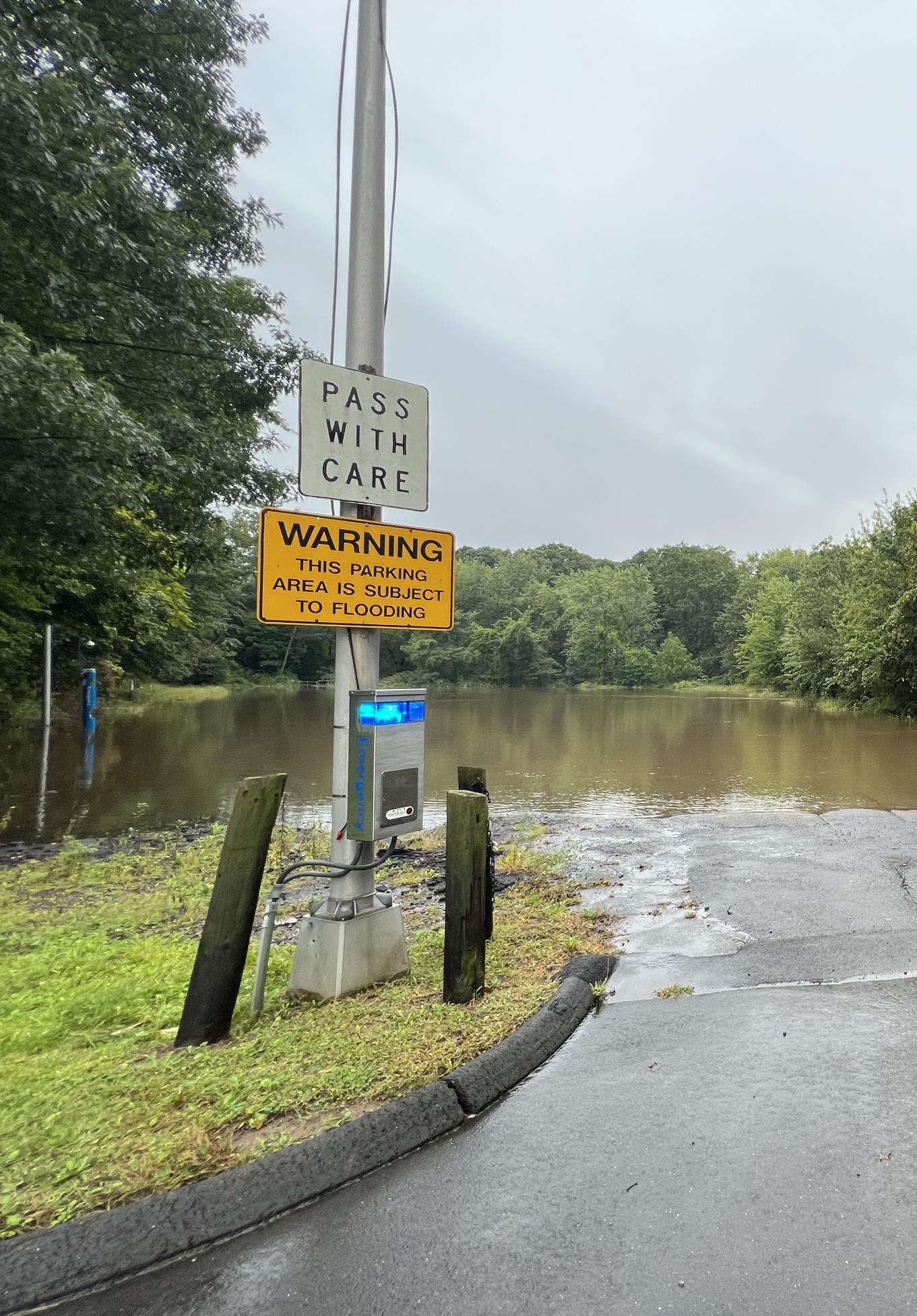
CLIMATE AND COMMUNITY RESILIENCE (CONTINUED)
Stormwater Flooding and Impervious Surface Mitigation
Drainage and street flooding during heavy precipitation events is common in many areas of the lower watershed because of large amounts of impervious surfaces, inadequate/undersized drainage systems, high groundwater and poorly drained soils, and the presence of combined sewers that become overwhelmed during large storms.
Upstream suburbanization in Bloomfield and West Hartford has had negative impacts on water quality and flooding in Hartford's North Branch neighborhoods: Blue Hills, Upper Albany, West End and Asylum Hill. Bloomfield has prioritized protection of the Farmington River and the Metacomet Ridge. Highdensity development along Filley Brook and around Copaco Plaza in Bloomfield has had detrimental impacts to the North Branch. Support from the City of Hartford, Greater Hartford Flood Commission, Capital Region Council of Governments, Connecticut Department of Energy and Environmental Protection and property owners is needed to mitigate the negative downstream impacts of increased stormwater runoff caused by siting large surface parking lots in the floodplains of the North Branch tributaries.
Drainage improvements, green stormwater infrastructure, and impervious surface reduction are recommended strategies for on-site stormwater infiltration that can increase resilience to stormwater flooding. Moreover, upstream green infrastructure requirements, and restrictions on impervious development can reduce the amount of stormwater flooding and combined sewer overflows.
❑ Implement drainage improvements to mitigate stormwater flooding, including new separate storm drainage systems in combined sewer areas (Granby Street/Blue Hills neighborhood),.
❑ Implement green stormwater infrastructure(GSI) throughstormwater retrofits, new development, and redevelopment on parcels and within the
public right-of-way (See Water Quality, Green Infrastructure and Low Impact Development recommendations).
❑ Encourage impervious surface reduction during public and private redevelopment projects, particularly in areas with highimpervious density.
❑ Promote increased tree plantings and greening of: 1) residential properties, 2) commercial properties for new development and redevelopment, 3) public roads through streetscape improvements and green streets approaches, and 4) capital improvementsat schoolyards, campuses, and institutional properties (See Habitat Restoration, Forests and Urban Tree Canopy recommendations).

CLIMATE AND COMMUNITY RESILIENCE (CONTINUED)
A. Riverine Flooding and Flood Management Increase resilience to riverine flooding along the North Branch Park River and its tributaries through natural channel design (river restoration) and floodplain restoration/manage ment.
1. Replace undersized culverts and bridges - Asylum Avenue Bridge and culverts downstream of Granby Street Conduit outlet (railroad and Mark Twain Drive). Evaluate other road-stream crossings in the watershed for potential replacement/upsizing. Prioritize crossings based on considerations of hydraulic restriction and flood risk, aquatic organism passage, geomorphic stability, and climate change (increased precipitation and flows).
2. Develop a hydraulic and sediment transport model (HECRAS) of the North Branch Park River to evaluate and design channel and floodplain improvementsto reduce riverine flood risk and geomorphic instability. The model can be used to prioritize and assess the cumulative effects of proposed flood resilience measures.
3. Manage large woody debris (LWD) - trees that have fallen into the river channel as a result of bank undercutting and can be mobilized by high flows and eventually get caught up in clusters that can create dams and adversely impact bridge and culvert openings. Management actions - through: 1) targeted removal (upstream of PRC inlet, upstream of Asylum Avenue, upstream of Albany Avenue) of LWD that poses a public health and safety hazard and 2) development and implementation of a maintenance plan for ongoing removal of hazardous LWD.
4. Develop and implement a North Branch Park River Maintenance Program - trash and debris cleanup, channel repairs, and storm drain outfall maintenance and repairs
All Hartford, West Hartford, Bloomfield, with Greater Hartford Flood Commission and North Park Task Force, CTDOT •
design
5. Perform targeted sediment removal along the North Branch Park River at the Park River Conduit inlet and Granby Street Conduit outlet
NBPR mainstem Hartford, West Hartford, Bloomfield, North Park Task Force, with Greater Hartford Flood Commission
mainstem Hartford, West Hartford, Bloomfield, North Park Task Force, with Greater Hartford Flood Commission
• Identified areas prone to LWD
• Days when removal activities
6. Implement improvements to the Park River Conduit inlet structure to create easier access to the structure to remove debris.
NBPR mainstem Hartford, West Hartford, Bloomfield, North Park Task Force, with Greater Hartford Flood Commission
• NBPR Maintenance Program completed 0-2 years (develop plan) Ongoing
NBPR mainstem Hartford, North Park Task Force, input from NRCS, Greater Hartford Flood Commission • Days when removal and grading activities occurred
NBPR mainstem Hartford, North Park Task Force, input from NRCS, Greater Hartford Flood Commission • Improvement plans 2-5 years
CLIMATE AND COMMUNITY RESILIENCE (CONTINUED)
A. Riverine Flooding and Flood Management
Increase resilience to riverine flooding along the NBPR and its tributaries through natural channel design (river restoration) and floodplain restoration/manage ment.
7. Complete preliminaryand detailed design of the North Branch Park River channel and floodplain improvements to improve flood resilience and geomorphicstability: 1) preserve existing and expand riparian floodplain to reduce damage to private structures and public infrastructure, 2) identify floodprone properties that could be considered for purchase and renaturalized as riparian floodplain, 3) reinforce sections actively eroding using a combination of natural features and rock structures, 4) recontour channel banks, as needed, to improve geomorphicstability of the fluvial system and create flood storage benches to provide increased flood storage capacity, 5) manage leaning trees, and 6) increase channel sinuosity to increase geomorphic stability.
8. Restore and re-naturalize developed portions of the North Branch Park River floodplain including the numerous parking lots along the river. Identify flood-prone properties and consider developing a voluntary buyout plan. Provide incentives and/or remove regulatory barriers to restoring and conserving privatelyowned parking lots in floodplains (replace lost parking).
B. Stormwater Flooding and Impervious Surface Mitigation
Increase resilience to stormwater flooding and extreme heat through drainage improvements, green stormwater infrastructure, and impervious surface reduction.
1. Implement drainage improvements to mitigate stormwater flooding, including new separate storm drainage systems in combined sewer areas (Granby Street/Blue Hills neighborhood),.
2. Implement green stormwater infrastructure (GSI) through stormwater retrofits, new development, and redevelopment on parcels and within the public right-of-way (See Water Quality, Green Infrastructure and Low Impact Development recommendations).
3. Encourage impervious surface reduction duringpublic and private redevelopment projects, particularly those in areas with high impervious density.
4. Promote increased tree plantings and greening of: 1) residential properties, 2) commercial properties for new development and redevelopment, 3) public roads through streetscape improvements and green streets approaches, and 4) capital improvementsat schoolyards, campuses,and institutional properties (See Habitat Restoration, Forests and Urban Tree Canopy recommendations).
NBPR mainstem North Park Task Force, Hartford
NBPR mainstem North Park Task Force, Hartford, private property owners
• Completed Hydraulic & Hydrologic (H&H) modeling
• Completed design
• Implementation funding obtained
• Projects
NBPR mainstem North Park
North Park Task Force, Hartford, West Hartford, Bloomfield
List of floodprone properties
North Park Task Force, Hartford, West Hartford, Bloomfield
City of Hartford Dept, Public Works, and Tree Commission, West Hartford, Bloomfield
Projects
EDUCATION AND STEWARDSHIP
Goal Statement: Educate citizens about the North Branch Park River watershed and the human and economic benefits of a healthy watershed. Involve the nine K-12 schools, three universities, and four cultural heritage sites located along the five-mile North Branch mainstem in learning activities and stewardship. Increase citizen stewardship by expanding community involvement in scientific research, history and arts cultural programming, and urban ecological conservation. Connecting people to local landscapes inspires a sense of appreciation, which is needed to establish sustainable environmental stewardship practices.
The Issue
The successful management of the North Branch Park River watershed requires an informed, engaged and committed group of organizations, agencies, municipal officials and staff, and local community members. The public is often unaware of the critical role they have in protecting water resources. Ongoing public education is essential to the long-term success of watershed management efforts by increasing awareness of water quality issues, fostering support for watershed management, and cultivating a long-term watershed stewardship ethic, particularly with respect to the benefits of green infrastructure.
Strategies
The public education and stewardship strategies focus on several target audiences, each of which has the potential to affect long-term change and improve water resource conditions in the North Branch Park River watershed.
Youth and Students
There are ten K-12 schools, three universities and four cultural heritage museum sites located along the North Branch Park River. This concentration of educational institutions along the North Branch offers a unique opportunity for innovative, experiential learning programs that can explore science, technology, engineering, art and math ("STEAM") as well as watershed history. Moreover, site-specific learning activities can focus on stormwater, green infrastructure, and conservation and restoration of the riparian landscapes along the North Branch Park River and the overall watershed.
Campuses and Institutional Property Owners
The institutional facilities within the North Branch Park River watershed (University of Hartford, UConn Law School, other schools, corporate campus facilities, hospitals, etc.) are major landowners that can have a significant impact on the water quality of the North
Branch Park River. An objective of this plan is to conduct outreach to campus facility managers and large property owners about the water quality impacts of campus development and management practices. Education and outreach programsshould emphasize the importance of green infrastructure and sustainable grounds management.
Residents and Homeowners
Although this watershed plan has focused on improvements to the riparian zone within Hartford city limits, North Branch water quality is impaired by residential and community development as well as permitted dischargesflowing from Bloomfield and West Hartford. Another outreach objective of this plan is to build awareness of land stewardship and land management practices that can reduce water quality impacts associated with residential land use, which is over 40% of the 29 square-mile North Branch Park River watershed. Key outreach topics include residential green infrastructure practices, sustainable lawn care, pet waste disposal, backyard riparian buffers and tree planting, and septic system maintenance.
Municipal Staff and Volunteer Commissions
This plan promotes awareness and stewardship of the watershed through the activities of municipal staff and land use commission members. Recommended strategies include improving the awareness of municipal employeesabout the potential impacts of their operations on water quality and promoting training for municipal staff and land use commission members on water quality protection, pollution prevention, and related regulatory mechanisms.
Businesses and Commercial Landowners
The commercial shoppingcenters, corporate office parks, light industrial facilities, and golf courses in the watershed, especially those located along the North Branch Park River and its tributaries, should be the focus of education and outreach on pollution prevention, riparian buffers, and involvement in watershed restoration activities.
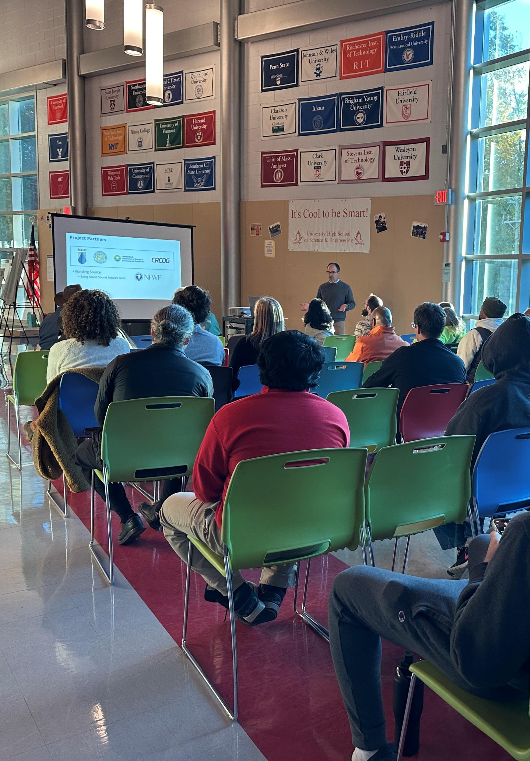
EDUCATION AND STEWARDSHIP (CONTINUED)
A. Youth and Students
B. Campuses and Institutional Property Owners
1. Create a K-12/higher education and stewardship network along the North Branch Park River. Work with administrators and teachers from individual schools to identify schools and grade levels that would benefit from watershed or related environmental education programs with a focus on innovative, experiential interdisciplinary learning programs. Include Connecticut Outdoor & Environmental Education Association (COEEA)
2. Strengthenparticipation of high school or college students in community service and volunteer watershed stewardship efforts such as stream and road-side cleanups, invasive species removal, trail and park maintenance, water quality and macroinvertebrate monitoring, rain garden installations, and other ecological restoration projects. Stormwater retrofit projects and environmental learning opportunities at schools in the watershed provide a good opportunity to involve students in the siting, installation, and maintenance of green infrastructure and LID practices.
NBPR mainstem: especially school along NBPR NRZs, K-12 schools and colleges/universities, land trusts, NCCD, North Park Task Force, local youth and students
• Network created and functioning across a designated digital platform 2-5 years Long Island Sound Futures Fund, USEPA Healthy Communities Grant Program for New England, CTDEEP Urban Forestry Grant programs, CT Community Investment Fund $$
All High school teachers in Hartford, Bloomfield and West Hartford schools, NCCD, Park Watershed, NRZs, North Park Task Force, and local youth community groups
3. Secure fundingfor an interdisciplinary symposium to support Park River watershed research and collaboration among college faculty and research staff, include University of Hartford, Trinity College, St. Joseph College, University of Connecticut, and Hartford International University for Religion and Peace. Park River regional watershed, with emphasison North Branch mainstem Colleges/universities, Park Watershed, and the North Park Task Force
• Volunteer stewardship events held
• Number of participants
• Symposiums that review research and design related to the watershed. Every other (or third) year hosted by different local school or cultural institution venue.
4. Secure fundingto endow faculty position/s dedicated to local environmental research Park River regional watershed Colleges/universities, Park Watershed, and the North Park Task Force • Funding secured • Hiring of faculty members
1. Conduct outreach to campus facility managers to demonstrate best practices and local resources regardinggreen infrastructure approaches, as well as operation and maintenance activities with potential for water quality impacts. Suggested topics include integrated pest management, turf management and low fertilizer usage, grass clippings management, leaf/brush waste management, parking lot and road maintenance (deicing, snow management), storm drainage system maintenance (catch basins, pipes,green stormwater infrastructure), and water quantity and flooding issues.
Campuses and institutional property owners, North Park Task Force, UConn Center for Land Use Education and Research (CLEAR)
• Outreach provided
• Participation from facility managers
• Updated campus maintenance guidelines that reflect current best practices.
Island Sound Futures Fund, USEPA Healthy Communities Grant Program for New England, CTDEEP Urban Forestry Grant Programs, CT
EDUCATION AND STEWARDSHIP (CONTINUED)
B. Campuses and Institutional Property Owners
C. Residents and Homeowners
2. Incorporate the goals, objectives, and recommended actions of the North Branch Park River Watershed Management Plan into ongoing and future campus maintenance and master plans
1. Build awareness of land stewardship and management practices and reduce nonpoint source impacts in residential areas througha focused homeowneroutreach program. Such a program could be modeled after other similar successful programs in Connecticut such as the River Smart program in the Pomperaug River watershed (www.pomperaug.org/riversmart).
Key outreach topics include residential green infrastructure practices (permeable pavement, rain gardens, downspout disconnection), sustainable lawn care, pet waste disposal, backyard habitat/riparian buffers and tree planting, and septic system maintenance.
D. Municipal Staff and Volunteer Commissions
1. Provide trainingfor public works staff and contractors on inspection and maintenance of green stormwater infrastructure (GSI) practices. Refer to existing training programs and resources on stormwater and GSI maintenance offered by groups such as UConn Center for Land Use Education and Research/NEMO (https://clear.uconn.edu/training/ctdeep-gsitraining/) and the Stormwater Innovation Center in Rhode Island (https://www.stormwaterinnovation.org/). Establish agreement for sharing maintenance equipment among the municipalities.
2. Conduct outreach to share natural best management practices on municipal and private golf courses; invite stakeholders of municipal parks and cemeteries.
North Park Task Force, Park Watershed, Land Trusts, NCCD, Property Owners, CRCOG • Outreach program established
Park River regional watershed North Park Task Force, Hartford, West Hartford, Bloomfield, UConn CLEAR
municipal staff and contractors
E. Businesses and Commercial Landowners
3. Provide trainingfor municipal planning, economic development, zoning, and land use commissions and boards in the watershed communities on riparian buffer protection and restoration, green infrastructure, floodplain management, and other topics relevant to the North Branch Park River watershed. All North Park Task Force, Hartford NEXT, Rivers Alliance of CT, CT DEEP, Hartford, West Hartford, Bloomfield, UConn CLEAR • Training completed by municipal land use commission and board members
1. Conduct outreach (e.g., visits, group training,and/or printed materials) to specific types of businesses in the watershed including light industry, real estate, offices, commercial retail centers, and golf courses. Suggested topics include pollution prevention, riparian buffers, and involvement in watershed restoration activities.
All North Park Task Force, NCCD, local businesses and property owners
• Outreach completed
Communities Grant Program for New England
5. LOCATION-SPECIFIC GREEN INFRASTRUCTURE PROJECTS
Green Infrastructure Design Process
Concept Development
Focus Area Concepts
Preliminary Designs
GREEN INFRASTRUCTURE
What is Green Infrastructure?
Green Infrastructure(GI) refers to natural and manmade landscapes and practices that reduce stormwater runoff using vegetation, soils, and natural processes to manage water and create healthier urban and suburban environments. These practices capture, manage, and/or reuse rainfall close to where it falls, reducing stormwater runoff and keeping it out of drainage systems, combined sewer systems, and receiving waters.
Examples of natural green infrastructure include forests, meadows, and floodplains and land conservation strategies to preserve these features in a natural or undeveloped state. Examples of man-made green infrastructure include Green Stormwater Infrastructure (GSI) for managing stormwater runoff at
the site or neighborhood scale, such as bioswales, rain gardens, green roofs, and rainwater harvesting, as well as other types of designed green infrastructure such as urban tree canopy, floodplain and riparian corridor restoration and conservation, and urban rewilding.
The Benefits of Green Infrastructure
In addition to reducing runoff and improving water quality, green infrastructure has been shown to provide many other social and economic benefits as highlighted in the following graphic.
Green Stormwater Infrastructure (GSI)


The multiple benefits of green infrastructure (Source: Carbon180).


Other Natural and Designed Green Infrastructure


Infiltration basins
Bioretention systems
Bioretention Planters Parking Lot Bioretention
Bioretention & Walking Trails Rain Gardens
Roadside Bioswales Green Streets
Urban Tree Canopy Small Urban Forests & Urban Rewilding
Riparian & Floodplain Restoration
DESIGN PROCESS
Introduction
A stepwise approach was used to identify and develop designs for “highimpact” green infrastructure (GI) projects within the North Branch Park River subwatershed, which was identified in the 2010North Branch Park River Watershed Management Plan as a focus for restoration and green infrastructure implementation. The focus area included targeted portions of the City of Hartford, the Town of West Hartford, and the Town of Bloomfield that contribute pollutant loadings to the North Branch Park River. Highimpact projects are generally larger-scale projects capable of achieving substantial reductions in pollutant (fecal indicator bacteria, nutrients, and sediment) loads and runoff volumes, with other benefits including but not limited to CSO reduction, increased resilience to flooding and extreme heat, and community enhancement.
The following major goals guided the selection and design of green infrastructure strategies and projects within the North Branch Park River subwatershed:
• Improve and protect water quality
• Restore and protect the riparian corridor
• Increase flood and community resilience
• Provide healthy neighborhood amenities
• Increase ecological and recreational connectivity
The design process built upon the site-specific green infrastructure concepts presented in the 2010watershed management plan. The designs were also informed by the project-specific community engagement process, including feedback from the Project Partners, Project Advisory Committee, community members, and other stakeholders.
Green infrastructure projects that were considered as part of the design development process for the North Branch Park River included:
• Green stormwater infrastructure (GSI) installations on public and institutional properties (parking lots, driveways, roofs, at existing outfalls, etc.)
• GSI within the municipal right-of-way (i.e., “Green Streets”)
• Tree planting and enhancement of urban tree canopy
• Riparian, stream, and floodplain restoration
• Land conservation to protect or preserve land in a natural or undeveloped state
• Walking paths and trails to connect restored riparian/floodplain areas, schools, institutional facilities, and landscapes.
GSI practices that have been shown to be appropriate within the City of Hartford and other areas of the watershed based on cost, maintenance, and effectiveness were considered. These included various types of bioretention systems (bioswales, rain gardens, tree box systems), stormwater wetlands and ponds, subsurface detention/retention systems, rainwater harvesting, green roofs, and infiltration systems where soil and groundwater conditions allow.
Data Gathering and Review
Geographic information system (GIS) infrastructure and site data were compiled from available sources for the lower, developed North Branch Park River subwatersheds in Hartford, West Hartford, and Bloomfield. Data sources included the watershed municipalities,the Metropolitan District (MDC), Capitol Region Council of Governments, and statewide GIS data layers. The information gathered consisted of:
• MDC and municipal storm, sanitary, and combined sewer system mapping
• Public and institutional parcel information
• Site data and mapping to help inform GI design including soil type, impervious areas, tree canopy, etc.
• Existing GSI or other stormwater treatment systems and planned stormwater retrofits to meet MS4 Permit impervious area reduction goals or other objectives
• Ongoing and planning capital improvement projects.

North Branch Park River Watershed green infrastructure design process
DESIGN PROCESS
Project Screening and Selection
Desktop Screening
A desktop screening-level review was performed to identify potential green infrastructure opportunities on public sites, within the public right-of-way, on institutional properties, and at major outfalls within the project area. The screening process enabled the project team to systematically identify potential green infrastructure project sites that were not originally identified in the 2010watershed management plan. The desktop screening made use of the mapping and GIS layers compiled in the data gathering and review process to identify sites within the project area with the strong potential for green infrastructure implementation. The screening-level review considered land ownership, physical site characteristics (soils infiltration potential and depth to groundwater), land use, impervious cover, storm drainage and combined sewer systems, and water quality impairments.
The desktop screening process identified approximately 90 parcels and locations for possible green infrastructure implementation projects. These were reviewed with the Project Partners and Project Advisory Committee, as well as through interviews with property owners (Hartford, West Hartford, Bloomfield, MDC, University of Hartford, and others), to assess potential support for green infrastructure projects on these sites. A matrix containing the screened parcels can be found in Appendix D
Field Inventories
Field inventories were conducted on December 14 and 15, 2023of the approximately 90 sites identified from the desktop screening process. The purpose of the field inventories was to confirm the physicalfeasibility of green infrastructure and to inform site selection and project designs. The site visits were used to confirm on-site and adjacent land use and development characteristics, impervious surfaces, drainage patterns, the presence of utilities, areas suitable for potential retrofits, and site constraints such as mapped low-permeabilitysoils or evidence of shallow groundwater or bedrock that could limit the feasibility of infiltration practices. Visual observations were recorded in a GIS-based field form.
Green Infrastructure Concepts
Site and neighborhood scale green infrastructure concepts were developed for locations where field inventories and feedback from property owners suggest potential for effective green infrastructure implementation. These concepts provide a high-level vision for green infrastructure – parcel-based GSI, green streets, riparian and floodplain restoration, land conservation, etc. – within the North Branch Park River subwatershed (refer to the site-specific green infrastructure recommendations in Appendix D). Plan view concept graphicswere developed for the overall subwatershed to show the application of green infrastructure typologies or strategies at the subwatershed scale. More detailed concept graphicswere developed at the site and neighborhood scale, organized into 13 different “focus areas,” which are presented later in this section.
Preliminary and Permit-Level Designs
Preliminary designs were developed for six (6) priority projects selected from the green infrastructure concepts. Project concepts that were advanced to preliminary design were selected based on feedback from the Project Partners, Project Advisory Committee and community engagement process. The preliminary designs include a brief design narrative, preliminary layout plan, order of magnitude opinion of cost, and a list of required permits and approvals. Full-scale preliminary design drawings can be found in Appendix E.
Permit level designs were then developed for the highest priority green infrastructure project (61 Woodland Street Riparian Restoration) selected from the preliminary design phase. Permit level designs are intended to support the local, state, and/or federal permitting process and include design drawings and narrative, updated cost estimate, and required permits and approvals. Full-scale permit level design drawings can be found in Appendix F
The following sections present concept, preliminary, and permit-level designs for selected green infrastructure projects in the North Branch Park River subwatershed.


CONCEPT DEVELOPMENT
FLOODPLAINS & RIPARIAN AREAS
The area along the North Branch Park River, which includes the floodplain, riparian area, and adjacent uplands, is a key integrating feature for green infrastructure.
Floodplain
A floodplain is the land area next to a river or stream that is susceptible to being inundated by floodwaters. Floodplains provide important social, economic and ecological functions such as floodwater storage and movement, groundwater recharge, water quality protection (trapping of sediment and nutrients), and wildlife and fish habitat. Floodplains are also places where people, human structures, and critical transportation infrastructure can be vulnerable to disruption and damage.
The regulatory floodplain, also referred to as the flood hazard area or zone, is the flood prone area adjacent to a river or stream defined by the return period of its inundation. For example, the 100-year floodplain corresponds to the area inundated by the flood with a return period of 100 years or a 1 percent chance of occurring in any given year (1 percent Annual Exceedance Probability).
The adjacent figure shows the 100-year and 500-year regulatory floodplains, as mapped by the Federal Emergency Management Agency (FEMA), for the North Branch Park River subwatershed.
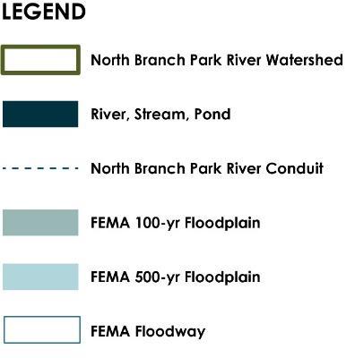

CONCEPT DEVELOPMENT
FLOODPLAINS & RIPARIAN AREAS
Riparian Area & Riparian Corridor
Riparian areas are the transition zone between terrestrial and aquatic systems and typically include streambanks, floodplains, wetlands and other systems adjacent to rivers and streams. Riparian areas characteristically have high water tables and are subject to periodic flooding. Healthy riparian areas (i.e., characterized by stable, healthy vegetation) have high ecological diversity, can maintain or improve water quality, and have both recreational and economic benefits.
The riparian corridor encompasses riparian areas, as well as adjacent upland areas needed to protect or restore
riparian function. For example, steep erodible slopes that could adversely affect the riparian area or the stream are included in the riparian corridor (see adjacent figure for steep slope areas along the North Branch Park River).
The management goal for riparian corridors is to maintain or restore the area to a vegetated condition to help filter pollutants and to protect riparian habitat and species. Mitigation measures can be located within the riparian corridor to protect water quality and riparian values.

CONCEPT DEVELOPMENT
FLOODPLAINS & RIPARIAN AREAS
DESIGN STRATEGIES
Riparian & Floodplain Restoration
Restore riparian areas and floodplains currently occupied by parking lots and other flood prone development to re-establish natural ecological system processes and functions (water quality, habitat, flood reduction, etc.). Restoration of these areas would involve converting portions of the existing parking lots to a more natural condition and function by removing the man-made infrastructure, removing non-native vegetation, amending the soils, and planting native trees and shrubs. Other modifications to the streambanks, riparian area, and floodplain may be warranted to re-connect the stream to its floodplain and restore lost hydrologic function and habitat.
Land Conservation
Protect or preserve land in a natural or undeveloped state through acquisition and/or conservation easement or other type of conservation restriction. Target existing undeveloped parcels along riparian corridors and in headwater areas, as well as areas proposed for riparian and floodplain restoration.
Conservation of North Branch riparian areas will require interdisciplinary collaboration to achieve feasible legal agreements and financing. New conservation strategies are needed, particularly for maintaining ecosystem service benefits and balancing conservation with property owner concerns and development interests.
Challenges
• Loss of existing parking and future development potential
• Voluntary cooperation of property owners
• Strategies and incentives to reduce parking and other impervious cover such as shared parking, stormwater user fee and credit system, and structured parking


LAND CONSERVATION OF FLOODPLAIN, RIPARIAN CORRIDOR, AND WOODED STEEP SLOPES
FLOODPLAIN AND RIPARIAN CORRIDOR, INCLUDING WOODED STEEP SLOPES
FLOODPLAIN RESTORATION OF EXISTING PARKING LOTS
RIPARIAN/FLOODPLAIN RESTORATION OF EXISTING PARKING LOTS


CONCEPT DEVELOPMENT
IMPERVIOUS SURFACES & POLLUTED RUNOFF
DESIGN STRATEGIES
Green Stormwater Infrastructure
Retrofit existing impervious surfaces with bioswales, rain gardens, infiltration systems, green roofs, and other green stormwater infrastructure (GSI) practices. Numerous GSI retrofit opportunities exist on public and institutional properties within the North Branch Park River subwatershed including parking lots, schoolyards, and along roads (green streets). Opportunities also exist for installation of larger subsurface storage and infiltration systems below athletic fields and parking lots.
Several areas of the watershed with combined sewers are slated for future sewer separation (e.g., Granby Street and Blue Hills neighborhood), creating the opportunity to incorporate GSI into the right-of-way (green streets) as part of the sewer separation and GSI treatment of new separated stormwater discharges that will serve these areas.
Challenges
• Voluntary cooperation of property owners
• Combined sewers in a large portion of the subwatershed. MDC currently prohibitsthe use of open-bottom stormwater infiltration systems in combined sewer areas due to concerns about groundwater potentially entering the combined sewer system through stormwater infiltration systems.
• Portions of the watershed are underlain by soils with low infiltration capacity (clay soils) and a highgroundwater table, which are challenging site conditions for implementation of infiltration-based GSI. This underscores the importance of careful GSI selection and design.
• Strategies and incentives to reduce impervious cover such as stormwater user fee and credit system


GREEN STREETS GREEN STORMWATER INFRASTRUCTURE IN PARKING LOTS
CONCEPT DEVELOPMENT
IMPROVED ECOLOGICAL & RECREATIONAL CONNECTIVITY
DESIGN STRATEGIES
Walking Paths and Trails
Create walking paths and trails within restored riparian/floodplain areas to connect area schools, institutional facilities, and landscapes to the river corridor and to the proposed Hartline multi-use trail. Boardwalks could be used within the restored floodplain to elevate the walking paths above the flood elevation.
Existing sidewalks, as well as new side paths and bicycle lanes added along existing roads, could provide connections between the walking path/trail network and existing or proposed green spaces in the watershed. The proposed walking paths/trailsand green streets can also serve as cooling corridors by providing shaded routes for walking and bicycling.
Design can enable the community to experience the North Branch in a variety of ways. Outdoor and indoor places with views of nature can benefit those using the space as well as property owners and developers. Strategies for connecting people with nature could include integrating walking paths and recreational trails with variations in the path geometry to provide visual interest as well as rest stops with educational signage and scenic outlooks.
River & Stream Crossings
There are numerous road crossings (culverts and bridges) of the North Branch Park River and its tributaries. These crossings have the potential to restrict wildlife (terrestrial and aquatic) passage, restrict flood flows and act as choke points for trees and debris, and contribute to erosion and degraded water quality. The road-stream crossings in the watershed should be evaluated for potential upgrade/replacement and related stream restoration.
Challenges
• Voluntary cooperation of property owners
• Public concern over proposed walking paths/ trails
• Engineering and fluvial geomorphic evaluation of river and road-stream crossings


EVALUATE RIVER CROSSING FOR REPLACEMENT


WALKING PATHS IN RESTORATION AREAS
TRAIL CONNECTIONS
FOCUS AREA CONCEPTS

SOUTH
OF FARMINGTON AVENUE

NORTH BRANCH PARK RIVER CONDUIT ENTRANCE


CLEMENS PLACE

GREEN STORMWATER INFRASTRUCTURE (TYP)

SHEPHERD PARK ELDERLY HOUSING


PARK RIVER CONDUIT


HARRIET BEECHER STOWE CENTER

SIDE PATH
CSO N-30 CSO N-22
GREEN ROOF (TYP)
GREEN ROOF (TYP)
NORTH BRANCH
GREEN STREETS (TYP)
FOCUS AREA CONCEPTS
FARMINGTON AVENUE TO ASYLUM AVENUE

SUBSURFACE STORMWATER STORAGE


CONNECTICUT MUSEUM OF CULTURE AND HISTORY


CLASSICAL MAGNET SCHOOL

CONNECTICUT COMMUNITY COLLEGES


WALKING TRAILS / LOOP
FLOODPLAIN RESTORATION WITHIN EXISTING PARKING LOTS


HARTFORD INTERNATIONAL UNIVERSITY FOR RELIGION AND PEACE

GREEN STORMWATER INFRASTRUCTURE (TYP)
GREEN STREETS (TYP)
POLLINATOR GARDEN
CSO N-10
CSO N-9
FOCUS AREA CONCEPTS
ASYLUM AVENUE TO HOMESTEAD AVENUE

SUBSURFACE STORMWATER STORAGE
FLOODPLAIN RESTORATION WITHIN EXISTING PARKING LOTS

WOODSIDE CIRCLE GOODWIN CIRCLE


LAND CONSERVATION
CONNECTICUT MUSEUM OF CULTURE AND HISTORY
EVALUATE EXISTING STREAM CROSSING (TYP)
CSO N-10

CLASSICAL MAGNET SCHOOL

CONNECTICUT COMMUNITY COLLEGES

CSO N-9
WALKING TRAILS / LOOP
POLLINATOR GARDEN
FOCUS AREA CONCEPTS HOMESTEAD AVENUE & GOODWIN’S WILD
EVALUATE EXISTING STREAM CROSSING (TYP)

PROPOSED SIDE PATH

GREEN STREETS IN FUTURE SEWER SEPARATION AREA (TYP)
FLOODPLAIN RESTORATION

EVERSOURCE ELECTRICAL SUBSTATION


GREEN STORMWATER INFRASTRUCTURE WITH BROWNFIELD REDEVELOPMENT
LAND CONSERVATION


FLOODPLAIN RESTORATION WITH FUTURE SITE REDEVELOPMENT
FUTURE HARTLINE MULTIUSE TRAIL
GREEN STREET SCARBOROUGH STREET
GOODWIN’S WILD (OLD GROWTH FOREST)
FOCUS AREA CONCEPTS UPPER ALBANY NEIGHBORHOOD

GREEN STREETS IN FUTURE SEWER SEPARATION AREA (TYP)


HANDEL PERFORMING ARTS CENTER AT UNIVERSITY OF HARTFORD


GSI WITHIN PARKING LOTS (TYP)


GREEN STORMWATER INFRASTRUCTURE WITH BROWNFIELD REDEVELOPMENT
FUTURE HARTLINE MULTIUSE TRAIL

GSI WITHIN PARKING LOTS (TYP)
ALBANY BRANCH
FOCUS AREA CONCEPTS
NORTH OF ALBANY AVENUE & MARK
TWAIN DRIVE

WALKING TRAIL


UNIVERSITY HIGH SCHOOL OF SCIENCE & ENGINEERING

FLOODPLAIN RESTORATION OF UHART PARKING LOT

UNIVERSITY OF HARTFORD MAGNET SCHOOL
GSI WITHIN PARKING LOTS (TYP)
LAND CONSERVATION

GREEN STREET ALONG MARK TWAIN DRIVE
FUTURE HARTLINE MULTI-USE TRAIL

EVALUATE EXISTING RIVER CROSSING (TYP)

ANNIE FISHER MONTESSORI MAGNET SCHOOL

ONGOING PHASED REDEVELOPMENT WITH LID/GSI
GSI TO TREAT FUTURE SEPARATE STORM DRAIN OUTFALL GSI TO TREAT FUTURE SEPARATE STORM DRAIN OUTFALL
FLOODPLAIN RESTORATION

FOCUS AREA CONCEPTS CRONIN PLAYGROUND & BLUE HILLS
NEIGHBORHOOD
LAND CONSERVATION – RIPARIAN AREA OF TRIBUTARY TO NORTH BRANCH PARK RIVER

GSI AT EXISTING STORM DRAIN OUTFALL (TYP)
GSI WITHIN PARKING LOT ISLANDS AND EDGES (TYP)


GREEN STREETS IN FUTURE SEWER SEPARATION AREA (TYP)

SUBSURFACE STORAGE SYSTEM
BENEATH ATHLETIC FIELDS TO MANAGE
STORMWATER FROM FUTURE SEPARATE STORM DRAINAGE SYSTEM


GSI WITHIN PARKING LOTS (TYP)
FOCUS AREA CONCEPTS
UNIVERSITY
OF HARTFORD – SOUTH


FOCUS AREA CONCEPTS
UNIVERSITY OF HARTFORD – NORTH

EVALUATE EXISTING STREAM CROSSING (TYP) FUTURE HARTLINE MULTI-USE TRAIL
GSI WITHIN PARKING LOT (TYP)
GSI WITHIN PARKING LOT (TYP)
GREEN STREET (TYP)
FOCUS AREA CONCEPTS ELIZABETH PARK

ENHANCED POND BUFFER


GSI ALONG PARK ROADS AND PARKING LOTS (TYP) ROADS AND IN


ELIZABETH PARK ROSE GARDEN

INTEGRATE GSI INTO FUTURE PARK IMPROVEMENTS CONSISTENT WITH UPDATED MASTER PLAN FOR ELIZABETH PARK EAST
GREEN STREET (TYP)
ELIZABETH PARK EAST
ELIZABETH PARK POND
FOCUS AREA CONCEPTS
BLOOMFIELD
AVENUE AND SIMSBURY ROAD
CORRIDOR – WEST HARTFORD


HEBREW CENTER FOR HEALTH & REHABILITATION

GSI WITHIN PARKING LOTS (TYP) LOTS
EVALUATE EXISTING STREAM CROSSING (TYP)

JEWISH COMMUNIY CENTER CAMPUS

GSI WITHIN PARKING LOTS (TYP)

PORTAGE ROAD AND SUNNY REACH DRIVE NEIGHBORHOOD


WEST HARTFORD


NEW ENGLAND JEWISH ACADEMY


BROOKDALE
GREEN STREETS (TYP)
LAND CONSERVATION
FOCUS AREA CONCEPTS
PORTAGE ROAD & SUNNY REACH DRIVE
NEIGHBORHOOD – WEST HARTFORD


HEBREW CENTER FOR HEALTH & REHABILITATION

GSI WITHIN PARKING LOTS (TYP) (TYP)
EVALUATE EXISTING STREAM CROSSING (TYP)

LAND CONSERVATION

JEWISH COMMUNIY CENTER CAMPUS
GREEN STREETS (TYP)
FOCUS AREA CONCEPTS
COPACO SHOPPING CENTER –
BLOOMFIELD


LOWE’S THE
GREEN ROOFS (TYP)
PRELIMINARY DESIGNS
Preliminary designs were developed for six (6) priority projects selected from the green infrastructure concepts. Project concepts that were advanced to preliminary design were selected based on feedback from the Project Partners, Project Advisory Committee, and community engagement process. The projects were also selected to reflect a range of green infrastructure strategies with broad applicability to other locations throughout the watershed.
As shown in the location figure, the sites selected for preliminary design include:
1. 282 Mark Twain Drive – Stormwater Park
2. University High School Parking Lot and Mark Twain Drive – Green Stormwater Infrastructure
3. 200 Mark Twain Drive – Bioretention System North of Athletic Field
4. 14 Mark Twain Drive – Stormwater Park
5. Classical Magnet School – Green Stormwater Infrastructure
6. 61 Woodland Street – Riparian Restoration
Sites 1-4 are located on the east side of the North Branch Park River along Mark Twain Drive and north of Albany Avenue. These green infrastructure projects are designed to manage runoff from existing development along Mark Twain Drive as well as from the Granby Street/Blue Hills neighborhoodsto the east, which is slated for separation of the combined sewer system and installation of a new separated storm drainage system. Sites 5 and 6 are along the lower reaches of the North Branch Park River south of Asylum Avenue, within the riparian corridor on the east side of the river.
The preliminary designs, which are approximately 30% level engineering designs, include a brief design narrative, preliminary layout plan (major design elements, grading, etc.), preliminary sizing calculations for green stormwater infrastructure (GSI), order of magnitude opinions of costs, and a list of required permits and approvals. GSI features were nominally sized to retain or treat the water quality volume (runoff generated from the first 1.3 inches of rainfall as defined in the 2024Connecticut Stormwater Quality Manual) or to maximize the removal of bacteria and nutrients to
the extent feasible (using the EPA Stormwater BMP Performance Curves) given available space and other site constraints. Full size plans and sizing calculations for the preliminary designs are included in Appendix E.
DESIGN ELEMENTS
Green Stormwater Infrastructure
Retrofit existing impervious surfaces with bioswales, rain gardens, infiltration systems, green roofs, and other stormwater practices. Implement GSI on public and institutional properties, along roads and sidewalks (green streets), and below existing athletic fields and other developed areas.
Riparian & Floodplain Restoration and Land Conservation
Restore riparian areas and floodplains currently occupied by parking lots and other flood prone development to re-establish natural ecological system processes and functions (water quality, habitat, flood reduction, etc.) including permanent conservation of the restored areas. Consider related stream restoration and road-stream crossing upgrades to address flooding, erosion, water quality, wildlife passage, and connectivity.
Recreational Trails, Native, Vegetation & Educational Connectivity
Create recreational trails within restored riparian areas and floodplains to bolster the educational goals of the plan. Establish educational stations and space within the restored riparian areas and floodplains that connect area schools to a network of real-time environmental information. Identify spaces that could be used for inperson education opportunities for students. Reestablish goals of the 1999Annie Fisher Nature Trail by supporting school projects that explore, monitor and share the riparian area through digital technology.

1. 282 MARK TWAIN DRIVE STORMWATER PARK
2. UNIVERSITYHIGH SCHOOLPARKING LOT AND MARK TWAIN DRIVE GREEN STORMWATER INFRASTRUCTURE
200
14
Approximate Drainage Area of MDC Proposed Separated Storm Sewer System (Typical)
5. CLASSICAL MAGNET SCHOOL GREEN STORMWATER INFRASTRUCTURE
6. 61 WOODLAND STREET RIPARIAN RESTORATION
Approximate Location of MDC Proposed Separated Storm Sewer Pipe (Typical)
4.
MARK TWAIN DRIVE STORMWATER PARK
3.
MARK TWAIN DRIVE BIORETENTION SYSTEM NORTH OF ATHLETIC FIELD
PRELIMINARY DESIGNS
282 Mark Twain Drive – Stormwater Park
Mark Twain Drive connects Albany Avenue with the University of Hartford including the University High School of Science and Engineering. The North Branch Park River runs parallel along the western side of Mark Twain Drive. The area north of University High School and south of the University of Hartford includes an open grassed area and a heavily forested area.
Within the neighborhood to the east, the “Granby Street and Blue Hills Neighborhood”,the Metropolitan District (MDC) is proposing a sewer separation concept which will include three new stormwater outlets to the North Branch Park River. The 84” northern most stormwater outlet, as proposed by MDC, will run through the University of Hartford Campus, approximately 450 feet north of the area between the University of Hartford and University High School.
RETROFIT CONCEPT
1. Stormwater Park: Install an offline stormwater wetland system within the grassed and forested area north of University High School to capture and treat diverted stormwater runoff from the Granby Street and Blue Hills neighborhood and portions of the adjacent Mark Twain Drive. A diversion structure and storm drainage pipe would convey a portion of the stormwater from the new separate storm system serving the northern portion of the Granby Street/Blue Hills neighborhood. Diverted stormwater would first enter a sediment forebay to allow sediment and debris to settle out, followed by further treatment in a curvilinear highmarsh and low marsh wetland zone, followed by final treatment in a permanent pool zone with a high-level overflow structure. The design includes a hardscape walking path on the southern edge of the stormwater wetland and an elevated boardwalk through the system with overlooks and educational signage throughout.
The stormwater wetland would serve as a “stormwater park,” managing stormwater from a large area and providing recreational and learning opportunities (e.g., living classroom) for the nearby schools and community.


PRELIMINARY DESIGNS
University High School Parking Lot and Mark Twain Drive – Green Stormwater Infrastructure
Mark Twain Drive connects Albany Avenue with the University of Hartford including the University High School of Science and Engineering. The North Branch Park River runs parallel along the western side of Mark Twain Drive.
RETROFIT CONCEPT
1. UHSSE Parking Lot Rain Gardens and Tree Trenches: Install a stormwater rain garden within the southernmost curbed median of the University High School parking lot to treat and infiltrate stormwater runoff as sheet flow from the western portion of the parking lot. Install a tree trench within the curbed median of High School parking lot to treat and infiltrate stormwater runoff from the eastern and western portions of the roadway. Two (2) curb cut inlets will direct stormwater runoff into the basin and the existing catch basins will function as overflow structures to convey larger flows to the existing storm drainage system.
2. Mark Twain Drive Bioswales: Remove the existing street parking along the western edge of Mark Twain Drive and install five (5) linear stormwater rain gardens in the excavated area to treat and infiltrate stormwater runoff as sheet flow from the western portion of the roadway. Existing catch basins along the western edge of the roadway will be relocated approximately five (5) feet to the east so as not to be within the rain garden. Six (6) curb cut inlets will direct stormwater runoff into the basins and the relocated catch basins will function as overflow structures to convey larger flows to the existing storm drainage system. Install a sediment forebay and pool at the inflow structure centrally located within the linear rain gardens to capture stormwater runoff and allow sediment and debris to settle. Replace the removed street parking with a 44-spot parking lot between Mark Twain Drive and the athletic fields. The existing concrete sidewalk will be relocated to run parallel along the eastern edge of Mark Twain Drive. An elevated boardwalk will be installed to run along the western edge of the linear rain gardens and restore the 1999Annie Fisher Nature Trail.

Note: Recommend removal of invasive trees and shrubs around project area.
PRELIMINARY DESIGNS
200 Mark Twain Drive – Bioretention System
North of Athletic Field
Mark Twain Drive connects Albany Avenue with the University of Hartford including the University High School of Science and Engineering athletic fields. The North Branch Park River runs parallel along the western side of Mark Twain Drive. The athletic fields are located on a 16.4-acre parcel owned by the City of Hartford Board of Education that also includes the housing development south of the fields. The area north of the athletic fields is currently a grassed open space approximately 130 feet from the existing northern tree line south to the athletic fields and approximately 450 feet from Mark Twain Drive east to the existing eastern tree line.
RETROFIT CONCEPT
1. Bioretention System: Install a stormwater rain garden within the grassed area north of the athletic fields to treat and infiltrate stormwater runoff from the eastern portion of Mark Twain Drive, new parking lot between the athletic fields and Mark Twain Drive (See Mark Twain Drive GI & University High School Parking Lot GI), and potential future connection with a subsurface storage system under the athletic fields. A curb cut inlet will direct stormwater runoff from Mark Twain Drive into a stormwater swale to convey the runoff to the basin through an inflow structure. Proposed underdrains will carry flow from the proposed parking lot and athletic field subsurface storage system to one of two (2) inflow structures. The two (2) inflow structures are located on the western and eastern sides of the stormwater rain garden. Install two (2) sediment forebays at the inflow structures to capture stormwater runoff and allow sediment and debris to settle. The existing catch basin and an overflow drain centrally installed within the basin will function as overflow structures to convey larger flows to the existing storm drainage system. A hardscape walking path with boardwalk crossing over the swale will surround the stormwater rain garden to provide public access.
Note: Recommend removal of invasive trees and shrubs around project area.
14 Mark Twain Drive – Stormwater Park
Mark Twain Drive connects Albany Avenue with the University of Hartford. The North Branch Park River runs parallel along the western side of Mark Twain Drive. The area of interest is heavily forested and bordered by Albany Avenue on the south, Mark Twain Drive on the east, and the North Branch Park River on the north and west. The site is located within the road right of way and a 17.2-acre parcel owned by the Housing Authority.
Within the neighborhood to the east, the “Granby Street and Blue Hills Neighborhood”, the Metropolitan District (MDC) is proposing a sewer separation concept which will include three new stormwater outlets to the North Branch Park River. The 84” southernmost stormwater outlet, as proposed by MDC, will run approximately 200 feet north of the site.
RETROFIT CONCEPT
1. Stormwater Park: Install a stormwater rain garden within the forested area at the western corner of Mark Twain Drive and Asylum Avenue to treat and infiltrate stormwater runoff from the Granby Street and Blue Hills Neighborhood. A diversion pipe from the new stormwater outlet will direct stormwater runoff into the basin. An overflow drain installed within the pool zone will function as an overflow structure to convey larger flows to the North Branch Park River. Install a sediment forebay at the inflow structure to capture stormwater runoff and allow sediment and debris to settle. Incorporate high marsh zones and low marsh zones within the basin to provide treatment and attenuation of stormwater flows. Install a hardscape walking path on the north and west edges of the stormwater rain garden with an overlook to enhance community engagement.
Anticipated

PRELIMINARY DESIGNS
Classical Magnet School – Green Stormwater Infrastructure
Classical Magnet School is a Public Magnet School at the corner of Asylum Avenue and Woodland Street. The North Branch Park River runs along the western boundary of the campus which sits on a 5.3-acre parcel.
RETROFIT CONCEPT
1. Parking Lot Rain Gardens: Install a swale and rain garden within the northern and southern portions of the existing parking island of the Classical Magnet School parking lot to treat and infiltrate stormwater runoff as sheet flow from the eastern portion of the lot. A curb cut inlet will direct stormwater runoff into a swale which will convey the stormwater to the basin. The existing catch basins will function as overflow structures to convey larger flows to the existing storm drainage system. Plant a pollinator area with shrubs, perennials, and seed mix in the middle portion of the parking island.
2. Asylum Avenue Rain Garden: Install a rain garden within the grassed area between the school building and Asylum Avenue to treat and infiltrate stormwater runoff as sheet flow from the northern portion of Asylum Avenue. Curb cut inlets will direct stormwater runoff into a stormwater swale to convey the runoff to the basin. The existing catch basins and overflow structure installed within the basin will convey larger flows to the existing storm drainage system. Install two (2) sediment forebays at the inflow structures to capture stormwater runoff and allow sediment and debris to settle. Install two (2) trench drains under the sidewalk on the southern and eastern sides of the basin to help attenuate flow through the rain garden.
3. West Edge Rain Garden: Remove accumulated sediment and nonnative vegetation from the existing 2008rain garden located between the parking lot and North Branch. Reconstruct existing rain garden to treat and infiltrate stormwater runoff as sheet flow from the northwestern portion of the parking lot. Three (3) curb cut inlets will direct stormwater runoff into the basin from the adjacent parking lot. The existing catch basins will convey larger flows to the existing storm drainage system. Install two (2) sediment forebays at the inflow structures on the north and south ends of the rain garden to capture stormwater runoff and allow sediment and debris to settle.
4. Driveway Subsurface Infiltration: Install two (2) subsurface infiltration systems along the northern driveway of the site to provide temporary storage and infiltrate runoff from the driveway, sidewalks, and adjacent parking lots. The subsurface infiltration systems include
an anti-seep collar to connected the solid and perforated pipe and cleanout for debris and sediment. The existing catch basins will convey larger flows to the existing storm drainage system.
5. Green Roof: Install green roofs on the Classical Magnet School building covering approximately 36,401square feet to reduce runoff volumes by retaining runoff and creating longer flow paths. The extensive green roofs will be a multilayered system with 6” of growth media and self-sustaining, resilient vegetation. Larger flows will be treated as runoff through the existing storm drainage system.
SITE SUMMARY
Parcel Owner City of Hartford Board of Education
Land Use 65% impervious area including school building, sidewalk, and parking areas with a narrow-grassed area between the parking lot and NBPR
Utilities and FEMA Floodway, 100- 500- year floodplain
Soil Type HSG D

Classical Magnet School – Green Stormwater Infrastructure
RETROFIT CONCEPT (CONTINUED)
61 Woodland Street – Riparian Restoration
61 Woodland Street is located off Asylum Avenue and is currently a State of Connecticut property (Connecticut State Colleges and Universities (CSCU) Board of Regents) managed by the Connecticut Department of Administrative Services (DAS). This 10.5-acre site was the campus of Capital Community College until 2002. The building, originally built in 1950for the Phoenix Insurance Company, is currently used as offices for CSCU, Department of Developmental Services, and Judicial Marshals and has ample parking near the building, above the floodplain.
Although the stream channel has been straightened and property lines have shifted, the site's western boundary is the North Branch Park River. Parts of that boundary is adjacent to the UConn School of Law campus. Due to seasonal flooding, a southwestern parking area (approximately 1.3 acre) within the floodplain is rarely used for parking. The deteriorated pavement is awash in sediment from seasonal deluges. Restoration of the floodplain across all or the western and southern portions of this lot is an exceptional cost-effective opportunity to strengthen riparian area vitality with green infrastructure. Given the location of the floodplain, a project that restores floodplain vegetation is eligible for funding through Connecticut's in-lieu fee program.

SITE SUMMARY
Parcel Owner State of Connecticut
Land Use Institutional (parking)
Utilities and FEMA Floodway, 100- and 500- year floodplain
Soil Type HSG D
61 Woodland Street – Riparian Restoration
RETROFIT CONCEPT
1. Floodplain Restoration: Restore the entire southwest parking lot and approximately 35 spaces of the western parking lot to a naturally vegetated riparian area including high-flow channels that provide hydraulic connections to the North Branch Park River. The restored riparian area consists of wetland micro-topography seeded with native riparian seed mix, riparian restoration trees and shrubs, upland riparian restoration areas planted with trees, shrubs, and seed mix, hummock and hollow wetland restoration microtopography, and pollinator areas planted with shrubs, perennials and seed mix. The design includes an elevated boardwalk loop (elevated above the base flood elevation) through the restored area with overlooks, benches, and educational signage.
2. Parking Lot Bioswale: Excavate approximately 24 spaces of the western parking lot and install a bioswale between the lot and North Branch Park River to treat and infiltrate stormwater runoff as sheet flow from the northwestern portion of the parking lot. No curbing will be installed between the parking lot and bioswale so runoff will sheet flow directly into the bioswale. Larger flows will be treated as overflow through the restored riparian area to the west of the bioswale and into the North Branch Park River. Install a hardscape walking path on the western boundary of the bioswale in the restored area that connects the elevated boardwalk to the sidewalk along Asylum Avenue.
3. Replace Asylum Avenue Bridge and Install Walking Path: Replace the existing Asylum Avenue bridge with a new bridge having a larger opening to increase the hydraulic capacity and reduce flooding. Connect the north and south sides of Asylum Avenue with an at-grade walking path below the bridge.


6. POLLUTANT LOAD REDUCTIONS
Pollutant Loads
Pollutant Load Reductions
POLLUTANT LOADS
Pollutant load refers to the quantity of a pollutant originating from point sources and nonpoint source runoff that is delivered to a surface waterbody over a given timeframe. Pollutant load estimates for the North Branch Park River watershed were initially developed as part of the 2010North Branch Park River Watershed Management Plan and subsequently revised for the 2018update of the MDC Combined Sewer Overflow Long-Term Control Plan.
The 2018pollutant load estimates serve as the baseline for this watershed management plan update since pollutant load modeling was not included in plan update scope.
2010 Pollutant Load Estimates
For the 2010watershed management plan, the Watershed Treatment Model (WTM) was used to estimate loadings of fecal coliform (fecal indicator bacteria), total nitrogen, total phosphorus, and total suspended solids to the North Branch Park River. The model was used to calculate watershed pollutant loads associated with nonpoint source runoff (i.e., stormwater) from various land uses as well as from other sources including combined and sanitary sewer overflows, illicit discharges, septic systems, managed turf, and road sanding.
The 2010model results showed that sewer overflows accounted for over 90% of the bacteria load to the lower North Branch Park River, with nonpoint source/stormwater runoff and illicit discharges accounting for the balance of the bacteria load. The model results also suggested that approximately 28% of the bacteria load from nonpoint source/stormwater runoff (i.e., nonsewer overflows) originated from the North Branch Park River subwatershed and 72% originated from the upstream tributaries. Residential land use was determined to account for approximately 80% of the nonpoint source/stormwater bacterial load for the overall watershed.
2018 Revised Pollutant Load Estimates
North Branch Park River pollutant load estimates were revised for the 2018 update of the MDC Combined Sewer Overflow Long-Term Control Plan (CSO LTCP). A comprehensive water quality monitoring program was implemented for the North Branch Park River Watershed in 2017and 2018to support the CSO LTCP update. The goal of the monitoring program was to better understand and quantify the relative contribution of fecal indicator bacteria from various sources in the watershed (e.g., combined sewer overflows versus stormwater runoff). The monitoring program included chemical and bacterial sampling at in-stream locations, stormwater outfalls, and CSO outfall locations during dry weather and wet weather events. Streamflow measurements were also taken to estimate pollutant loads using a mass balance approach.
Dry Weather Monitoring Results
The recreational water quality standard for the fecal indicator bacteria E. coli (410 MPN/100 mL) was exceeded in approximately 17% of the dry weather samples collected in 2017and 2018. These exceedances occurred in upstream tributaries and along the North Branch Park River, suggesting the presence of dry weather bacteria source(s) that influencefecal indicator bacteria concentrations such as illicit discharges, waterfowl, and groundwater inflow.
Wet Weather Monitoring Results
E. coli concentrations were significantly elevated during wet weather. E. coli concentrations were above the recreational water quality standard at most locations during the sampled wet weather events. Most NBPR sampling locations exceeded the water quality standard during wet weather events even when there were no CSO overflows. These results indicate that fecal indicator bacteria concentrations in the river are strongly influenced by stormwater and nonpoint source runoff throughout the watershed.
In wet weather events, exceedances of the recreational water quality standard were observed in the upstream tributaries to the North Branch Park River and in the mainstem of the river upstream of CSO influence, indicating that even in areas of the watershed not impacted by CSOs, wet weather conditions lead to exceedance of the recreational water quality standard
Annual Bacterial Loads
Based on sampling conducted in 2017and 2018, upstream sources (upstream of the University of Hartford and the upstream tributaries) are estimated to account for approximately 33% of the annualbacteria load in the North Branch Park River. CSOs are estimated to contribute approximately 13% to 22% of the annual E. coli load, which affects the approximately 2.5-mile segment of the lower river downstream of the CSO regulators. Stormwater runoffand other watershed sources such as illicit discharges and groundwater inflow account for the remaining45% to 54% of the annualload. Refer to the adjacent figure.
The results of the annual bacteria loading analysis further suggest that upstream and other sources are significant contributors of fecal indicator bacteria to the North Branch Park River and that elimination of CSOs from the North Branch Park River will not eliminate the recreation use impairment in the river without other solutions that address stormwater runoff such as green stormwater infrastructure and other watershed management actions.

Estimated relative contributions of fecal indicator bacteria (annual E. coli loads) to the lower North Branch Park River based on 2017 and 2018water quality and flow monitoring(2018Long-Term Control Plan Update, The Metropolitan District).
POLLUTANT LOAD REDUCTIONS
Load Reduction Targets – Statewide Bacteria TMDL
The CT DEEP 2012Statewide Bacteria Total Maximum Daily Load (TMDL) establishes load reduction targets for fecal indicator bacteria (E. coli) for the North Branch Park River. A TMDL is a “pollution budget” that identifies the reductions in point and nonpoint source pollution that are needed to meet Connecticut water quality standards for a particular waterbody and a strategy to implement those reductions to restore water quality.
The TMDL identifies percent reductions in geometric mean (92%) and single sample (98%) E. coli concentrations required to meet recreational water quality criteria. These percentages are for reducing fecal indicator bacteria concentrations at ambient monitoring locations in the river, not at the end of stormwater outfalls or other pollutant loads to the river. It is important to note that the impairment and percent reductions are based on a limited data set that is over 10 years old. The 2017-2018MDC water quality monitoring data for the North Branch Park River also suggest that similarly large reductions in E. coli concentrations (98% reduction in geometric mean concentrations), and corresponding reductions in fecal indicator bacteria loads, are needed to consistently attain the Connecticut Water Quality Standards numeric criteria for freshwater non-swimming recreation.
Load Reductions for Proposed Green Stormwater Infrastructure
Pollutant load reductions for the proposed green stormwater infrastructure (GSI) preliminary designs were estimated using the EPA Region 1 stormwater performance curves, which are part of the Connecticut Stormwater Quality Manual and the New England Stormwater Retrofit Manual. The performance curves are used to estimate long term pollutant load reduction (percent removal) based on the type of GSI practice, hydrologic soil group, and design storage volume expressed as a runoff depth over the contributing impervious area. The pollutants considered include total phosphorus, total nitrogen, fecal indicator bacteria, total suspended solids, and metals. Estimated annual quantities of pollutants removed (in pounds per year, or billion colonies per year in the case of bacteria) were calculated from the percent removal values and pollutant loads calculated from published pollutant load export rates for various land uses.
As shown in the table below, GSI retrofits sized to treat the water quality volume (runoff from the first 1.3 inches of rainfall), and even GSI retrofits with smaller design volumes, can provide substantial load reductions in fecal indicator bacteria, nutrients, and other stormwater pollutants.
Estimated pollutant load reductions for proposed green stormwater infrastructure retrofit preliminary designs
Note that the proposed stormwater parks, which are designed as off-line systems to capture a portion of the stormwater runoff from the residential drainage areas in the Granby Street/Blue Hills neighborhood, provide lower pollutant removals (9% to 12% removal of bacteria loads) due to the large size of the contributing drainage areas relative to the available land area at the outfalls, which limits the design storage volume of the proposed stormwater wetlands. This underscores the need for additional GSI implementation within the Granby Street/Blue Hills neighborhood (in addition to other management practices) to furtherreduce stormwater pollutant loads associated with the new separated stormwater outfalls following separation of the combined sewers in this area.
Sewer separation and elimination of CSOs will further reduce the annual bacteria load to the aboveground portion of the North Branch Park River by 13% to 22%. In addition to sewer separation, the 2010pollutant load modeling suggests that stormwater retrofits, open space protection (including riparian corridor conservation), illicit discharge detection and elimination, and septic system maintenance/repairs have the greatest potential for bacteria load reductions in the North Branch Park River watershed.
7. FINANCIAL ASSISTANCE
Funding Sources
FUNDING SOURCES
Variouslocal, state, and federalsourcesof fundingand financingare available for the implementationof this watershedmanagement plan. Appendix C containsa list of potentialfundingand financingsources.The list is a startingpoint to identify and apply for grantsand seek other types of fundingand financingfor implementationof this watershedplan. Possible sources of fundingor financingfor specific recommendationsare also listed in the tables foundin Section4 of this Plan.
The followingsourcesof financialassistance have broad applicability to many of the larger and more costly watershedplan recommendations(e.g., green infrastructure design and implementation, land acquisition and conservation,riparian corridorrestoration,urban landscape design, and others):
• CT DEEP Climate Resilience Fund (DCRF): CT DEEP has announcedthe strategic expansion of its municipalresilience grant program to better enable communitiesto access federalfundingfor climate resilience.This upcominginvestmentof state funds will help towns, Councils of Government, and other stakeholderspursueproject planning, and in some cases construction,allowing them to tap into the billions of federaldollarsavailable to improve local resilience.
• CT DECD Community Investment Fund (CIF): The Community InvestmentFund2030 fosterseconomic developmentin historicallyunderservedcommunities across the state. CIF will provide a total of up to $875 million to eligible municipalitiesas well as not-forprofit organizationsand communitydevelopment corporationsthat operate within them. Grantsare available to eligible municipalitiesand non-for-profit organizationsfor capital improvementprograms (e.g., brownfieldremediation,infrastructure)and planning for capital improvementprojects (e.g., community engagement, feasibility studies, project design).
• Hartford Foundation for Public Giving: Although HartfordFoundationfor Public Giving (HFPG)has not identifiedenvironmentalhealth as a priority outcome area, donor advised fundshave supported programs that prioritizenature as valuable to community wellbeing.
• Stormwater Authorities: A user fee-based system that providesa dedicatedsource of income to help financeand maintainstormwaterinfrastructure. Stormwaterauthoritiesgenerate revenue throughuser fees rather than taxation.The Capitol Region Council of Governments(CRCOG) has been awardeda DCRF grant to support developinga stormwaterauthority feasibility studyin the CRCOG region.This studywill examine the viability of implementinga regional stormwaterutility in approximately eight municipalities within the region.
• FEMA Hazard Mitigation Assistance Grant Programs: FEMA’s Hazard MitigationAssistance grant programs provide fundingto protect life and property from future naturaldisasters.HMA grant programs include the Hazard MitigationGrant Program (HMGP),BuildingResilient Infrastructure and Communities (BRIC), and Flood MitigationAssistance (FMA),
• NFWF Long Island Sound Futures Fund (LISFF): Providesgrant fundingfor project planningthrough implementationfor projects that meet high-priority conservationobjectives in local communitiesto protect and restoreLong Island Sound.Priorities include clean waters and healthy watersheds, educatingto engage sustainableand resilient communities, soundscience, and inclusive management.
• CT Green Bank: ConnecticutGreen Bank offers financingand incentivesfor resiliencymeasures.In 2021, the Green Bank’smodel was expandedto include new areas of environmentalinfrastructure related to climate adaptationand resiliency.Their approach to environmentalinfrastructureincludeshard infrastructure improvementswhich increase social and ecological resilienceas well as nature-basedsolutions which encompass a wide range of actions to protect, manage, or restore naturalor modified ecosystems to addresschallenges, includingclimate change.

APPENDIX A
Status of Recommendations from the 2010 Watershed Management Plan

Status of Recommendations from the 2010 Nobrth Branch Park River Watershed Management Plan
RECOMMENDATION
GOAL A – PLAN IMPLEMENTATION
Objective A-1. Establish Watershed Organization
Establish independent Park River watershed stewardship organization
Secure funding and hire watershed coordinator
Establish NBPR advisory committee to guide plan implementation
Adopt watershed management plan through Memorandum of Agreement (MOA)
Identify potential funding sources and submit grant applications
Objective A-2. Conduct Additional Field Assessments
GOAL B – WATER QUALITY
Objective B-1. Reduce or Eliminate CSO Discharges
Perform additional stream and upland assessments
PRWRI Completed 2012- 2013 Park Watershed established as a 501c3 organization
Park Watershed Partially Implemented
Park Watershed Partially Implemented
Municipalities & Park Watershed Partially Implemented
Municipalities & Park Watershed Partially Implemented
Park Watershed Partially Implemented
Project specific funding (319 NPS Grant, Urban Bird Treaty, LISFF) and partial funding for part-time watershed coordinator position
Park Watershed Board and committee meetings held several times per year
Plan not formally adopted by watershed municipalities through MOA. Plan referenced in municipal Plans of Conservation and Development.
Project specific funding (319 NPS Grant, Urban Bird Treaty, LISFF)
Additional stream walks performed along North Branch Park River in Hartford
Implement CSO Long Term Control Plan MDC Ongoing 2018 MDC CSO Long Term Control Plan Update and Integrated Plan working with CT DEEP and municipalities
2022 Consent Order with CT DEEP
MDC has spent over $1.2 billion removing 550 million gallons (from an annual average CSO volume of 1,040 million gallons) of combined sewer overflows since 2005.
• Upgrading Hartford Wastewater Treatment Plant
• Rehabilitation of over 700 acres consisting of sewer separation, lining and cleanout work to create capacity, cleaning out pipes to remove residue, and re-lining old pipes to be more hydraulically sealed
• Installation of more than 25 miles of new sanitary sewer and drainpipes
• Disconnection of the Gully Brook watercourse from the sewer system achieving
July 2023 CT DEEP and MDC amended the 2022 Consent Order to prioritize work in North Hartford including rehabilitation of private sewer connections CTDEEP approved $185 million worth of projects to address sewer and stormwater-related flooding and backups in North Hartford, for which the state is providing $137 million in grants, subsidies, and low-interest loans. The remaining costs will be covered within MDC's rate structure. A total of 12 separate projects have been identified, planned for 20232026.
Lack of buy-in from municipal leadership in Hartford, Bloomfield, and West Hartford
Watershed municipalities not focused on North Branch Park River
RECOMMENDATION
ACTIONS/TASKS
Consider Green Infrastructure in combination with LTCP
LEAD ENTITY STATUS NOTES
MDC Partially Implemented
2004- 2014 Park Watershed participation in Citizens Advisory Commission (CAC) - monthly meetings and green infrastructure sub-committee meetings
Green infrastructure strategies identified in 2018 CSO LongTerm Control Plan Update
BARRIERS TO IMPLEMENTATION
Disagreement between MDC and City of Hartford regarding responsibilities for operation of the stormwater management system in Hartford including green infrastructure implementation and maintenance and MS4 Permit compliance
2018 CSO Long-Term Control Plan Update does not identify site-specific green infrastructure opportunities in the North Branch Park River watershed
Objective B-2. Implement LID and Green Infrastructure
Evaluate feasibility of incorporating green approaches in LTCP and City of Hartford stormwater management program
MDC & Hartford Partially Implemented
2010 Green Capitol Project by MDC and CT DEP (initiated by PRWRI/Park Watershed and City of Hartford)
2012 MDC Rain Barrel Program. MDC and City of Hartford continued- the Rain Barrel Program in conjunction with the City’s Roof Leader Disconnection Program.
2017 City of Hartford hired a Green Infrastructure Specialist with grant assistance from the Connecticut Institute for Resilience and Climate Adaptation. The position continues to be housed within the City of Hartford Office of Sustainability.
2018 City of Hartford Green Infrastructure Handbook
Green infrastructure strategies identified in 2018 CSO LongTerm Control Plan Update
Lack of dedicated and adequate funding for green stormwater infrastructure implementation (design, construction, and maintenance) in municipal retrofits and capital projects
Concerns that green stormwater infrastructure (GSI) practices are impractical in the City of Hartford due to the presence of soils with high clay content and low infiltration rates. GSI can be effectively utilized within Hartford for stormwater retention and pollutant removal despite the high percentage of clay- heavy soils based on recent EPA studies
Perceived infeasibility of GSI due to cost of implementation and maintenance. Like all stormwater management systems, there are up-front and ongoing maintenance costs for GSI. However, GSI provides numerous other uses and benefits compared to traditional stormwater infrastructure.
Disagreement between MDC and City of Hartford regarding responsibilities for operation of the stormwater management system in Hartford including green infrastructure implementation and maintenance and MS4 Permit compliance
2018 CSO Long-Term Control Plan Update does not identify site-specific green infrastructure opportunities in the North Branch Park River watershed
Implement LID/BMPs for Albany Avenue and Granby Street Outfalls
MDC Partially Implemented
Implement green infrastructure demonstration projects
MDC & Hartford Partially Implemented
2023 City of Hartford and EPA (through the University of New Hampshire Stormwater Center) demonstration project to implement green stormwater infrastructure in the Granby Street area to help alleviate localized flooding
2010 Green Capitol Project by MDC and CT DEP (initiated by PRWRI/Park Watershed and City of Hartford)
Require consideration of green approaches in MDC project design
MDC Partially Implemented
2023 City of Hartford and EPA (through the University of New Hampshire Stormwater Center) demonstration project to implement green stormwater infrastructure in the Granby Street area to help alleviate localized flooding
2023 MDC and City of Hartford partnering on a drainage study of the North Branch Park River and Blue Hills/Granby Street area
Green infrastructure strategies identified in 2018 CSO LongTerm Control Plan Update
BARRIERS TO IMPLEMENTATION
Modify municipal land use regulations to promote LID
Municipalities Partially Implemented
2016 City of Hartford Zoning Regulations revisions require the use of Low Impact Development and green infrastructure practices wherever feasible and design of stormwater management systems in accordance with the Connecticut Stormwater Quality Manual for all projects requiring a zoning permit
Updates to Bloomfield and West Hartford land use regulations in progress or still needed to meet the postconstruction stormwater management requirements of the MS4 Permit
Disagreement between MDC and City of Hartford regarding responsibilities for operation of the stormwater management system in Hartford including green infrastructure implementation and maintenance and MS4 Permit compliance
2018 CSO Long-Term Control Plan Update does not identify site-specific green infrastructure opportunities in the North Branch Park River watershed
Limited or lack of enforcement of existing regulations by municipal land use commissions. Limited enforcement of MS4 Permit requirements relative to required legal mechanisms.
Adopt green infrastructure and LID in municipal projects
Municipalities Partially Implemented
Implement priority stormwater retrofits Park Watershed & Municipalities Partially Implemented
Objective B-3. Identify and Eliminate Illicit Discharges Targeted illicit discharge investigations
MDC, CT DEEP, EPA, and Municipalities
Ongoing
Municipalities have identified stormwater retrofit opportunities for municipal projects as part of MS4 Permit requirements
2023 - CRCOG awarded CT DEEP Climate Resilience Grant
Funds to undertake regional stormwater utility feasibility study
Construction of bioretention basins at 110 Sherman Street parking lots
Construction of green stormwater infrastructure elements (rain gardens, permeable pavement, and riparian buffer plantings) as part of re-design and restoration of Filley Park in Bloomfield
MDC, working with CT DEEP and EPA, is implementing programs to reduce and/or eliminate CSOs discharges to rivers and sanitary sewer overflows (SSOs). EPA's 2006 Consent Decree requires MDC to develop and implement sewer system operation and maintenance improvement programs to control overflows from its sewers in the surrounding member communities.
Lack of dedicated and adequate funding for green stormwater infrastructure implementation (design, construction, and maintenance) in municipal retrofits and capital projects
Funding has historically been limited for largescale implementation of stormwater retrofits. Funding and financing opportunities for green stormwater infrastructure retrofits has increased substantially in recent years.
As part of EPA's work with CTDEEP to review the cause of sewer overflows in Hartford, EPA conducted an inspection of MDC's system in January 2023. As a follow-up to EPA's January 2023 inspection, EPA Region 1 issued letters to MDC and the City of Hartford to request information on plans for sewer separation, responsibility for stormwater management, reporting of overflows, and other questions.
Municipalities implementing IDDE programs as part of MS4 Permit requirements.
BARRIERS TO IMPLEMENTATION
Objective B-4. Protect and Restore Riparian Buffers
Implement municipal IDDE programs
Municipalities Ongoing
Objective B-5. Implement Water Quality Monitoring Program
Implement priority stream cleanup efforts
Priority riparian buffer restoration projects
Adopt/strengthen stream buffer regulations
Incorporate minimum buffer widths into municipal wetland r egulations
Adopt incentives for developers to restore degraded buffers
Amend Greater Hartford Flood Commission regulations
Develop and implement long-term monitoring program
Park Watershed Ongoing
Park Watershed & Municipalities Partially Implemented
Municipalities Not Implemented
Municipalities Not Implemented
Municipalities Not Implemented
Hartford Not Implemented
Park Watershed Not Implemented
Municipalities implementing IDDE programs as part of MS4 Permit requirements
City of Hartford has a draft written IDDE Plan but is working to refine the plan to update the stormwater system mapping for City-owned and operated portions of the separate storm sewer system.
2007- Present Source to Sea Cleanup: Park Watershed with groups from University of Hartford, CCSU, UConn Law, Trinity College, and West Hartford Boy Scout Troop #44
Construction of green stormwater infrastructure elements (rain gardens, permeable pavement, and riparian buffer plantings) as part of re-design and restoration of Filley Park in Bloomfield
Disagreement between MDC and City of Hartford regarding responsibilities for operation of the stormwater management system in Hartford including green infrastructure implementation and maintenance and MS4 Permit compliance
Implement field monitoring study of LID effectiveness
GOAL C – HABITAT PROTECTION AND RESTORATION
Objective C-1. Enhance Instream and Riparian Habitat
Park Watershed Not Implemented
Conduct fish passage assessments
Fish passage feasibility assessment of University of Hartford dam
Sporadic water quality monitoring has been conducted in the NBPR watershed by various organizations (CT DEEP, Trinity College, MDC, and others) but a long-term coordinated routine water quality monitoring program has not been implemented
Recommendation is outdated. A large body of research and practice now exists on the effectiveness of LID and green stormwater infrastructure.
Park Watershed Not Implemented
University of Hartford Completed
2012 University of Hartford dam removal, pedestrian bridge construction, and addition of native vegetation along NBPR
Lack of dedicated funding and staff resources
RECOMMENDATION
ACTIONS/TASKS
Revise local stream crossing & stormwater design standards
Implement priority stream restoration projects
Implement stream daylighting projects
Objective C-2. Protect and Enhance Forests and Urban Tree Canopy and Restore Understory Vegetation
Conduct watershed-wide urban tree canopy analysis
Municipalities Not Implemented
Hartford & Bloomfield Partially Implemented
Hartford & Bloomfield Not Implemented
Park Watershed Partially Implemented
Construction of a new fishway on Wash Brook/Filley Park Pond as part of re-design and restoration of Filley Park in Bloomfield
2023 City of Hartford awarded a USFS Urban and Community Forestry Grant in the amount of $6 million to increase tree canopy in disadvantaged communities in Hartford by addressing dead/dangerous tree conditions, extreme heat, and deteriorated public parks
2020 City of Hartford Tree Canopy Action Plan, which charts an implementation course to allow the City the ability to protect and grow Hartford’s tree canopy. Neighborhoods in NBPR identified in plan as high (Upper Albany and Asylum Hill) to medium (Blue Hills) priority for tree planting.
2020 Tree Resource Management Plan, City of Hartford
2019 Tree Inventory by Davey Tree Inventory and Management
2018- 2019 City of Hartford Tree Plan – 2018-2019, City of Hartford Tree Advisory Committee
2017 City of Hartford Climate Action Plan
2015 Urban Tree Canopy Assessment and Planting Plan, American Forests
2010 A Report on the City of Hartford, Connecticut’s Existing and
Possible Tree Canopy, University of Vermont
Develop Town-based UTC goals and plan
Amend municipal regulations
Implement priority reforestation projects
Engage tree wardens in watershed municipalities
Implement reforestation/tree canopy demonstration projects
Landowner education, stewardship, and incentive programs
Municipalities Partially Implemented
Municipalities Not Implemented
Municipalities Partially Implemented
Park Watershed Partially Implemented
Park Watershed Partially Implemented
Park Watershed Partially Implemented
2020 City of Hartford Tree Canopy Action Plan, which charts an implementation course to allow the City the ability to protect and grow Hartford’s tree canopy
See notes for items above
See notes for items above
See notes for items above
See notes for items above
RECOMMENDATION
Adopt City of Hartford Tree Ordinance and develop master plan
Promote urban agriculture, community gardens
Objective C-3. Control Invasive Species
Develop invasive species management plan
Implement priority invasive species management projects
GOAL D – SUSTAINABLE GROWTH AND LAND USE
Objective D-1. Promote Smart Growth
Modify municipal land use codes, ordinances, and plans
Objective D-2. Protect Open Space Priority land acquisitions and conservation restrictions
Continue to implement municipal open space plans
Seek alternative funding sources for open space acquisition
Promote use of open space through trail maps and events
Identify and protect priority farmland
Objective D-3. Promote LowImpact, Context- Sensitive Greenways
Develop a Greenway between Bloomfield & Hartford that protects the stream corridor and links to neighborhood cultural points of interest
Incorporate LID and conservation design elements
Objective D-4. Increase Public Access to the River
Enhance river access on public lands
Develop public access inventory for the watershed
Implement signage, interpretive stations, and online resources
Provide linkages between the river and cultural institutions
Hartford Partially Implemented
Municipalities Partially Implemented
Status
See notes for items above
2016 City of Hartford Zoning Regulations revisions to further encourage urban agriculture, including beekeeping and henhouses
2017 City of Hartford Climate Action Plan includes strategies to encourage urban agriculture
Park Watershed Not Implemented
Municipalities, Park Watershed, & Landowners Not Implemented
Municipalities Partially Implemented
Municipalities Ongoing
Municipalities Ongoing
Municipalities Ongoing
Park Watershed Partially Implemented
2016 City of Hartford Zoning Regulations revisions
LaSalette Park, Town of Bloomfield with Wintonbury Land Trust (now Traprock Ridge Land Conservancy)
Park Watershed with University of Hartford, National Trail Day events
Bloomfield Ongoing Wintonbury Land Trust (now Traprock Ridge Land Conservancy)
Hartford & Bloomfield Ongoing
Hartford & Bloomfield Ongoing
Municipalities Partially Implemented
Park Watershed Not Implemented
Park Watershed Partially Implemented
Hartford Not Implemented
Varies by property owner
GOAL
E – PUBLIC EDUCATION AND STEWARDSHIP
Objective E-1. Creation of Education & Stewardship Network
Develop framework for watershed place-based K- 12 education
Park Watershed Ongoing
Park Watershed and CT DEEP Water Festival at Annie Fisher Montessori
2017 North Branch educators meeting
Develop educational toolkit and school stewardship network
Park Watershed Ongoing
2017- 2018 Nomad 9: Hartford Art School University of Hartford MFA program
2016- 2017 River Ambassadors program: Park Watershed
2011 City as Living Lab: Park Watershed/University of Hartford
BARRIERS TO IMPLEMENTATION
Objective E-2. Campus Facility Managers Outreach
Organize and host workshops to demonstrate best practices
Park Watershed Partially Implemented
Encourage awareness and involvement by students and faculty
Universities and Schools Partially Implemented
Objective E-3. Residential Outreach Foster a “block-by-block” approach for the restoration and conservation of stream reaches and ponds
Increase watershed stewardship signage in residential areas
Encourage and provide incentives for disconnection of roof runoff
Park Watershed & Landowners Ongoing
Municipalities Not Implemented
Municipalities Partially Implemented
Develop education/outreach materials Park Watershed Ongoing
2017 Park Watershed/NCCD maintenance meeting
2007- Present Source to Sea Cleanup: Park Watershed with groups from University of Hartford, CCSU, UConn Law, Trinity College, and West Hartford Boy Scout Troop #44
2016- 2017 River Ambassadors program: Park Watershed/U niversity of Hartford
Since 2013 UConn ENVE ~3 Senior projects with Park Watershed
Park Watershed/NCCD focus properties between Asylum and Farmington Avenues
Deliver education/outreach to the public
Objective E-4. Municipal and Business Outreach
Review municipal facility compliance
Improve municipal stormwater management programs
2012 MDC Rain Barrel Program
Park Watershed/University of Hartford City as Living Lab Blue- Green maps
Park Watershed ongoing tabling and presentations
Municipalities Ongoing Park Watershed/University of Hartford City as Living Lab Blue- Green maps
Park Watershed ongoing tabling and presentations
Municipalities Not Implemented
Municipalities Partially Implemented
Develop education/outreach materials Park Watershed Partially Implemented
Deliver education/outreach to the public
Increase watershed stewardship signage in commercial areas
Municipalities Partially Implemented
Municipalities Not Implemented
Municipalities updated and are implementing stormwater management programs in response to requirements of the 2017 MS4 Permit
2017- 2018 City of Hartford hired Green Infrastructure Specialist
Park Watershed participation in City of Hartford Parks & Recreation Advisory Commission meetings and West Hartford and Bloomfield Planning & Zoning meetings
Municipalities implemented public education and outreach programs as part of the MS4 Permit program
North Branch Park River Watershed Community Survey and Results
North Branch Park River Community Survey


Watershed Community Survey

Watershed Survey Results
• An online watershed survey was developed to obtain additional feedback from the community and other stakeholders on issues of concern in the North Branch Park River watershed
• 140 responses were received

Watershed Survey Results

Watershed Survey Results

Watershed Survey Results

Watershed Survey Results

Watershed Survey Results
Key Findings on Flooding Issues
● Frequent Basement Flooding: Regular occurrences, ranging from mild to severe, especially during heavy rain.
● Other Flooding Reports:
○ Backyard and local flooding, including riverfront areas like the boathouse/park.
○ Large puddles on walking paths (woodland and asylum).
○ Sewer overflows impacting basements and running into rivers.
● Contributing Factors:
○ Excessive pavement in urban areas (e.g., Hartford parking lots).
○ Tree falls and property damage due to flood-related conditions.
● Trends: Minor basement flooding over the past 4-5 years, escalating to severe this year.
Watershed Survey Results

Potential Funding Sources
Wetlands Restoration Partnership (CWRP)
FINANCIAL ASSISTANCE PROGRAMS
There are multiple Land and Water Conservation Fund (LWCF) programs that provide funding to federal, state and local governments to purchase land, water and wetlands for the benefit of all Americans.
The Corporate Wetlands Restoration Partnership (CWRP) is an innovative private-public initiative aimed at preserving, restoring, enhancing and protecting aquatic habitats throughout the United States. Bringing together corporations, federal and state agencies, non-profit organizations and academia, the CWRP allows members to contribute in a fundamental way to crucial projects involving America’s coastal and inland aquatic resources and support related education programs. Since its inception in 1999, CWRP has aided in the restoration of more than 64,000 acres and 1,050 stream miles through the monetary donations and in-kind services of its corporate partners.
FEMA’s Hazard Mitigation Assistance grant programs provide funding to protect life and property from future natural disasters.
• Hazard Mitigation Grant Program (HMGP) assists in implementing long-term hazard mitigation measures following a major disaster.
• Building Resilient Infrastructure and Communities (BRIC) funds hazard mitigation projects with a focus on capacity building, innovation, large infrastructure, and partnerships.
• Flood Mitigation Assistance (FMA) provides funds for projects to reduce or eliminate risk of flood damage to buildings that are insured under the National Flood Insurance Program (NFIP) on an annual basis.
FEMA provides state and local governments with preparedness program funding to enhance the capacity of their emergency responders to prevent, respond to, and recover from a range of hazards.
The Community Development Block Grant (CDBG) program is a flexible program that works to ensure decent affordable housing, provide services to the most vulnerable in our communities, and create jobs through the expansion and retention of businesses. CDBGfinanced projects could incorporate green infrastructure into their design and construction.
Through its on-the-ground conservation programs, the National Forest Foundation supports action-oriented projects that directly enhance the health and well-being of America's National Forests and Grasslands and that engage the public in stewardship.
https://www.cooperativecons ervation.org/viewproject.aspx ?id=965
Hazard Mitigation Assistance Grants | FEMA.gov
https://www.fema.gov/nondisaster-grants-managementsystem
Community Development Block Grant Program | HUD.gov / U.S. Department of Housing and Urban Development (HUD)
https://www.nationalforests. org/grant-programs
Five Star and Urban Waters Restoration Grant
The Five Star and Urban Waters Restoration Program seeks to develop nation-widecommunity stewardship of local natural resources, preserving these resources for future generations and enhancing habitat for local wildlife. Projects seek to address water quality issues in priority watersheds, such as erosion due to unstable streambanks, pollution from stormwater runoff, and degraded shorelines caused by development. The program focuses on the stewardship and restoration of coastal, wetland and riparian ecosystems across the country.
https://www.nfwf.org/progra ms/five-star-and-urbanwaters-restoration-grantprogram
High-priority conservation objectives in local communities that aim to protect and restore Long Island Sound; clean waters and healthy watersheds; educating to engage sustainable and resilient communities; sound science and inclusive management.
Long Island Sound Futures Fund | NFWF
New England Forests and Rivers Fund
The National Fish and Wildlife Foundation (NFWF) New England Forests and Rivers Fund is dedicated to restoring and sustaining healthy forests and rivers that provide habitat for diverse native bird and freshwater fish populations in the six New England states. Major funding for the New England Forests and Rivers Fund is provided by Eversource Energy, the U.S. Fish and Wildlife Service, and the U.S. Department of Agriculture’s Natural Resources Conservation Service and Forest Service.
http://www.nfwf.org/newengl and/Pages/home.aspx
Community-Based Habitat Restoration Program Grant NOAA
NOAA’s Community-Based Restoration Program provides funding and technical assistance for restoration projects that ensure fish have access to high-quality habitat. The goal of these projects is to recover and sustain fisheries—particularly those species managed by NOAA Fisheries, or those listed as endangered or threatened under the Endangered Species Act.
https://www.fisheries.noaa.g ov/national/habitatconservation/communitybased-habitat-restoration
NOAA Community-Based Restoration Program Partnership Grant NOAA
These grants are designed to provide support for local communities that are utilizing dam removal or fish passage to restore and protect the ecological integrity of their rivers and improve freshwater habitats important to migratory fish.
Other NOAA grant programs: Coastal Resilience Grants Program, Ocean Acidification Program, Environmental Literacy Program
https://www.fisheries.noaa.g ov/national/habitatconservation/strategichabitat-restoration
Long Island Sound Futures Fund
New England Bay Watershed Education and Training (B-WET)
NRCS Watershed and Flood Prevention Operations Program (WFPO)
NOAA’s Bay Watershed Education and Training (B-WET) program is an environmental education program that promotes place-based experiential learning for K–12 students and related professional development for teachers.This funding opportunity focuses on projects combining long-term, classroom-integrated “Meaningful Watershed Educational Experiences” and capacity building for K-12 Environmental Literacy at the state and local level.
Provides technical and financial assistance to states, local governments and tribes to plan and implement watershed project plans for the purpose of watershed protection, flood mitigation, water quality improvement, fish and wildlife enhancement, wetlands and wetland function creation and restoration, groundwater recharge, and wetland and floodplain conservation easements.
Watershed Protection and Flood Prevention Operations (WFPO) Program | Natural Resources Conservation Service Kresge Foundation Environment Program
Kresge’s Environment Program helps cities combat and adapt to climate change while advancing racial and economic justice. Efforts supported include greenhouse gas emission reduction, preparing for effects of climate change, and advancing social cohesion and equity.
https://kresge.org/ourwork/environment/#ourstrategies
Clearing and Snagging Projects (Section 208 of the 1954 Flood Control Act) Technical Assistance USACE
Channel clearing and excavation, with limited embankment construction by the use of materials from the clearing operation to reduce nuisance flood damages caused by debris and minor shoaling of rivers.
Clearing and Snagging Projects (Section 208)
Flood Damage Reduction Projects (Section 205 of the 1948 Flood Control Act) Technical Assistance USACE
Floodplain Management Services Assistance (Section 206 of the 1960 Flood Control Act, PL 86-645) Technical Assistance USACE
Conservation Reserve Program (CRP) Financing Strategy USDA FSA
Projects are planned and designed to provide the same complete flood control project that would be provided under specific congressional authorizations. Flood control projects are not limited to any particular type of improvement. Levee and channel modifications are examples.
Study only (not detailed final design or construction). Floodplain delineation, dam failure analyses, flood damage reduction, stormwater management, flood proofing, and inventories of flood prone structures.
The Farm Service Agency (FSA) Conservation Reserve Program is a voluntary program that provides annual rental payments and cost-share assistance to farmers in exchange for improving environmental quality by converting environmentally-sensitive land from agricultural production to vegetative cover such as native grasses, trees, and riparian buffers.
USACE Flood Damage Reduction Projects (Section 205)
Floodplain Management Services (Section 206)
Conservation Reserve Program (CRP) | Farm Service Agency
New England B-WET Program
Emergency Watershed Program (EWP)
Environmental Quality Incentives Program (EQIP)
The program provides technical and financial support to help local communities relieve imminent hazards to life and property caused by natural disasters that impair a watershed. Various activities are eligible including stream channel debris removal, restoration of eroded streambanks, levee repair, and land buyouts.
Emergency Watershed Protection | Natural Resources Conservation Service
This program provides technical and financial assistance to farmers, ranchers, and forest landowners for implementation of conservation measures on their lands.
Environmental Quality Incentives Program | Natural Resources Conservation Service
Healthy Forests Reserve Program (HFRP)
Healthy Forests Reserve Program | Natural Resources Conservation Service Regional Conservation Partnership Program
Helps landowners restore, enhance and protect forestland resources on private lands and tribal lands through easements and financial assistance.
Projects where NRCS and partners co-invest in impactful and innovative solutions to onfarm, watershed, and regional natural resource concerns. Proposed projects must generate conservation benefits by addressing specific natural resource objectives in a state/multistate area or address one or more primary resource concerns within an NRCSdesignated critical conservation area (CCA).
Regional Conservation Partnership Program | Natural Resources Conservation Service
Watershed Protection and Flood Prevention Operations (WFPO) Program
The program provides funding to federal, state, local , and federally-recognized tribal governments to execute watershed projects (<= 250k acres) for a variety of purposes including flood prevention, watershed protection, public recreation, and water quality management.
Watershed and Flood Prevention Operations (WFPO) Program | NRCS (usda.gov)
US Forest Service Community Forest Program (CFP)
Competitive grant program that provides financial assistance to tribal entities, local governments, and qualified conservation non-profit organizations to acquire and establish community forests that provide community benefits. Community benefits include economic benefits through active forest management, clean water, wildlife habitat, educational opportunities, and public access for recreation.
https://www.fs.usda.gov/ma naging-land/privateland/community-forest
Rebuilding American Infrastructure with Sustainability and Equity (RAISE) Discretionary Grant Program Grant
Promoting Resilient Operations for Transformative, Efficient, and Cost-Saving Transportation (PROTECT) Grant Program
and Discretionary Funding
National Culvert Removal, Replacement, and Restoration Grant Program (Culvert Aquatic Organism Passage (AOP) Program)
Long Island Sound Community Impact Fund (LISCIF) Technical and Financial Assistance USEPA, Restore America's Estuaries, and Long Island Sound Study
RAISE provides funding for planning and capital projects that will improve safety, environmental sustainability, quality of life, mobility and community connectivity, economic competitiveness, state of good repair, partnership and collaboration, and innovation.
Formula program funding to State DOTs to help make surface transportation more resilient to natural hazards, including climate change, sea level rise, flooding, extreme weather events, and other natural disasters through support of planning activities, resilience improvements, community resilience and evacuation routes, and at-risk costal infrastructure. Partnerships or discretionary funding available to municipalities.
An annual competitive grant program that awards grants to municipalities, states, and tribal governments for the replacement, removal, and repair of culverts or weirs that meaningfully improve or restore fish passage for anadromous fish, as well as increase resilience to climate change and resilience of critical infrastructure.
Provides technical and financial assistance to communities with environmental justice concerns to address environmental issues and improve the quality and accessibility of the Long Island Sound. Technical assistance will be provided through LISCIF and is available to communities/organizations even if one does not submit a funding proposal.
The EPA Brownfields and Land Revitalization Program supports states, Tribal Nations, communities and other stakeholders in working together to prevent, assess, safely clean up and sustainably reuse brownfield sites.
The Grants Program sponsored by EPA's Office of Environmental Education (OEE), Office of External Affairs and Environmental Education, supports environmental education projects that enhance the public's awareness, knowledge, and skills to help people make informed decisions that affect environmental quality.
EPA helps communities improve their development practices and get the type of development they want. EPA works with local, state, and national experts to discover and encourage development strategies that protect human health and the environment, create economic opportunities, and provide attractive and affordable neighborhoods for people of all income levels.
Rebuilding American Infrastructure with Sustainability and Equity (RAISE) Grant Program | US Department of Transportation
Funding Resources for Watershed Protection and Restoration
This page provides information on funding, technical, planning, and capacity building resources.
Culvert Grant Program
Island Sound Community Impact Fund
Brownfields Program Grants | US EPA
https://www.epa.gov/educati on/environmental-educationee-grants
https://www.epa.gov/smartgr owth/epa-smart-growthgrants-and-other-funding
https://www.epa.gov/nps/fun ding-resources-watershedprotection-and-restoration
National
Long
Healthy Communities Grant Program for New England Grant USEPA
The Water Finance Clearing House Grant USEPA
Water Infrastructure and Resiliency Finance Center Grants USEPA
North American Wetlands Conservation Act (NAWCA) US Standard Grants Grant USFWS
United States Fish and Wildlife Service (USFWS) Natural Resource Assistance Grants Grant USFWS
New England's main competitive grant program to work directly with communities to reduce environmental risks to protect and improve human health and the quality of life in Target Investment Areas. Projects should target resources for at-risk communities, reduce environmental and human health risks, increase collaboration through partnerships and community-based projects, build institutional and community capacity, and achieve measurable environmental and human health benefits.
A database of federal financial sources which may fund a variety of watershed projects.
Provides financing information to help local decision makers with decisions regarding drinking water, wastewater, and stormwater infrastructure.
NAWCA provides matching grants to organizations and individuals who have developed partnerships to carry out wetlands conservation projects in the United States, Canada, and Mexico for the benefit of wetlands-associated migratory birds and other wildlife.
The USFWS administers a variety of natural resource assistance grants to governmental, public and private organizations, groups and individuals.
The Partners Program provides technical and financial assistance to private landowners and Tribes who are willing to work with USFWS and other partners on a voluntary basis to help meet the habitat needs of Federal Trust Species. The Partners Program can assist with projects in all habitat types which conserve or restore native vegetation, hydrology, and soils associated with imperiled ecosystems such as longleaf pine, bottomland hardwoods, tropical forests, native prairies, marshes, rivers and streams, or otherwise provide an important habitat requisite for a rare, declining or protected species.
EPA - Healthy Communities Grant Program
Water Finance Clearinghouse | US EPA
https://www.epa.gov/waterfi nancecenter
North American Wetlands Conservation Act (NAWCA) U.S. Standard Grants | U.S. Fish & Wildlife Service
http://www.fws.gov/grants/
http://www.fws.gov/partners/
National Fish Passage Program Financial and Technical Assistance USFWS
Congressionally Directed Spending / Community Project Funding
Congressionally Directed Spending
U.S. Congress / Senate Appropriations Subcommittee
Projects that improve the ability of fish or other aquatic species to migrate by reconnecting habitat that has been fragmented by a barrier such as a dam or culvert, including culvert replacement and culvert upsizing projects, which also provide flood resilience benefits.
Formerly and colloquially referred to as “earmarks,” Community Project Funding (CPF) is defined as any congressionally directed spending or tax benefit that would benefit an entity or a specific state, locality, or congressional district. Since the funding is specified to a recipient, it is by nature not subject to competitive award processes. Potentially eligible projects range from infrastructure, community programs, and other local initiatives.
National Fish Passage Program
FY 2025 Congressionally Directed Spending
FINANCIAL ASSISTANCE PROGRAMS
AND FINANCING)
The National Audubon Society, Inc., through its Connecticut program (Audubon Connecticut) is the sponsor of an In-Lieu Fee Program for aquatic resource compensatory mitigation required by Department of the Army authorizations. Audubon Connecticut administers a competitive grant funding program, soliciting proposals for wetland and waters restoration, enhancement, creation and/or preservation.
Connecticut Department of Economic and Community Development (CT DECD) Community Investment Fund is a statewide program authorized in Section 32-285a of the Connecticut General Statutes. Grants are available to eligible municipalities and non-forprofit organizations for capital improvement programs (e.g. brownfield remediation, infrastructure) and planning for capital improvement projects (e.g. community engagement processes, feasibility studies, development of project plan and construction budget).
Brownfield projects may be eligible for other state and federal financial incentives such as historic tax credits, urban renewal tax credits and other DECD administered programs. The Connecticut Office of Brownfield Remediation and Development (OBRD) can help municipalities and developers to identify all relevant programs for which a project might be eligible.
Planning and project development; nature based solutions, gray infrastructure, and nonstructural projects; Projects shall be integrated into relevant plans to ensure eligibility for implementation through existing and new federal funding programs, in consultation with partners; support to assist communities with applying for federal resilience grants
https://portal.ct.gov/connecti cutclimateaction/executiveorder/deep-climateresilience-fund
Land acquisition for conservation, recreation, habitat enhancement, enhancing and conserving water quality.
Federal Clean Water Act Section 319 funds, administered by CTDEEP, are intended to effectively and efficiently address nonpoint source pollution are available to municipalities, nonprofit environmental organizations, regional water authorities/planning agencies, and watershed associations. Section 319 funds may be used for watershed based plans implementation projects, watershed based plan
Open Space and Watershed Land Acquisition Grant Program
Clean Water Section 319 Nonpoint Source Grants
CT In Lieu Fee Program
OBRD Brownfield Funding
Clean Water Fund
Community Resilience Engagement and Technical Assistance
CTDEEP Recreational Trails Grants Program
STATE
Planning, design and construction of wastewater collection and treatment projects; The CWF currently includes set-asides or reserves categories for green infrastructure, river restoration and small community wastewater (including decentralized) systems.
Clean Water Fund
Creation, utilization, and operation of stormwater authorities and municipal flood prevention, climate resilience and erosion control boards pursuant to Public Act 21-115; prioritizing assistance to vulnerable populations; addressing short-term and long-term impacts of climate change; integrating all relevant planning documents; facilitating dialogue among vulnerable populations, state, regional and local stakeholders.
Since 2015, CTDEEP’s recreational trails program has provided funding to non-profits, municipalities, state departments and tribal governments in support of trail construction and/or restoration projects, accessibility improvements, purchase of trail maintenance equipment, land acquisition, and educational programs. Requests should be under $1million, and a 20% match is required.
Program being developedmore information to become available
Long Island Sound License Plate Program
Section 14-21e of the Connecticut General Statutes (CGS) authorizes the issuance of the Long Island Sound license plate by the Department of Motor Vehicles, while CGS Section 22a-27k establishes the Long Island Sound Fund to be administered by the Department of Energy and Environmental Protection into which proceeds from the sale of the plates are deposited.
License Plate Program
CTDEEP Recreation and Natural Heritage Trust Program
The Recreation and Natural Heritage Trust program was created by the Legislature in 1986 in order to help preserve Connecticut’s natural heritage. It is the CTDEEP’s primary program for acquiring land to expand the state’s system of parks, forests, wildlife, and other natural open spaces.
The Recreation and Natural Heritage Trust Program
CT Recreational Trails
CTDEEP
LIS
CTDEEP Urban and Community Forestry Planning Grant Program Grant CT DEEP
STATE
The Urban and Community Forestry Planning Grant Program offers funding for municipalities and non-profit organizations to pursue planning projects such as tree inventories, management plans, or other monitoring programs that will help communities to make informed management decisions.
Urban Forestry Grant Opportunities
CTDEEP Urban Forest Equity Grant Program Grant CT DEEP
CTDEEP Urban Forest Resilience Grant Program Grant CT DEEP
Through the Inflation Reduction Act, historic funding is available to municipalities, nonprofits, and other eligible organizations to increase equitable access to trees and the benefits they provide in disadvantaged communities throughout Connecticut. More information and how to apply for this program
Urban Forestry Grant Opportunities
The State Urban Forest Resilience Grant Program supports efforts to restore and improve urban forests lost due to catastrophic losses from Emerald Ash Borer and other pests and diseases while building resiliency through tree diversity and the protection of existing trees. Funds can be used for management and reforestation including tree planting and tree removals.
Urban Forestry Grant Opportunities
CTDEEP Urban Forested Natural Areas and Riparian Corridor Restoration Grant Program Grant CT DEEP
Through financial support provided by the Bipartisan Infrastructure Law, DEEP’s Urban and Community Forestry Program is requesting proposals for the Urban Forested Natural Area and Riparian Corridor Restoration Grant Program. Awards are for $2,500-$20,000. Local government entities and non-profit 501(c)3 organization are eligible to apply. There is no financial match required.
Urban Forestry Grant Opportunities
STATE
Drinking Water State Revolving Fund (DWSRF) Program Financing Strategy
CT Department of Public Health
Provides long-term below market rate loans to community and non-profit, noncommunity public water systems (PWSs) to finance infrastructure improvement projects. Provides funding for projects that promote green infrastructure and energy or water efficiency, as well as projects that demonstrate new or innovative ways to manage water resources in a sustainable way.
Drinking Water State Revolving Fund Program
Small Town Economic Assistance Program (STEAP) Grant
CT Office of Policy and Management
Urban Act Grant Program Grant
CT Office of Policy and Management
Projects involving economic and community development, transportation, environmental protection, and public safety. Bloomfield is eligible to opt into the STEAP program. Hartford and West Hartford are not eligible for STEAP funding.
Small Town Economic Assistance Program - STEAP
Climate Smart Land Stewardship Grant Program Grant
CTDOAG, CT Land Conservation Council
CT Department of Agriculture (CT DOAG) Farmland Restoration, Climate Resiliency & Preparedness Grant (RRP) Grant CTDOAG
CTDOT Local Transportation Capital Improvement Program Grant CTDOT
The Urban Act grant program is open to all municipalities designated as economically distressed, public investment communities or urban centers. Funds are provided to improve and expand state activities which promote community conservation and development and improve the quality of life for urban residents of the state.
A new fund for land trusts offered by the Connecticut Land Conservation Council (CLCC) with support from the Connecticut Department of Agriculture. This program will award $500,000 over multiple years for both planning and implementation grants. Planning Grants: Designed for organizations in the early stages of developing a climate smart land stewardship project, these grants can fund the background research and plan development needed to implement a climate smart project. Examples include developing a forest management plans, pollinator planting plans, or work plans for implementing specific climate-smart practices. Implementation Grants: Larger grants will be available to assist land trusts with implementing these climate smart practices on their preserves.
Urban Act Grant Program
Climate Smart Land Stewardship Grant Program
The main objective of this voluntary program is to increase the State’s resource base for food and fiber production agriculture focusing primarily on prime and important farmland soils. Farmland Restoration Grant
The Local Transportation Capital Improvement Program (LOTCIP) provides State funds to urbanized area municipal governments in lieu of Federal funds otherwise available through Federal transportation legislation. Under the LOTCIP, the COGs across Connecticut will be responsible for the solicitation, ranking and prioritizing of their municipal members’ project proposals. Potential source of funding for stormwater green infrastructure associated with roadway improvement projects (green streets).
Highway Design-Local RoadsLOTCIP
Projects that align with the Sustainable CT roadmap of actions that promote high-quality, healthy, and inclusive neighborhoods and towns.
Supports community-driven projects that foster resident engagement and build collaboration between residents and their local government. Partnership with a nonprofit, civic-oriented crowdfunding organization that provides fundraising coaching and support, and an online fundraising platform to help all project leaders publicize their work and fundraise for their project. Sustainable CT provides a live match to every donation a project receives. Anyone in a Sustainable CT registered municipality can participate in this program, meaning that municipalities themselves, schools, libraries, nonprofits, community groups, and even individual residents can all propose a project and access the funding.
https://sustainablect.org/fun ding/
Embrace-A-Stream (EAS) is a matching grant program administered by TU that awards funds to TU chapters and councils for coldwater fisheries conservation.
http://www.tu.org/conservati on/watershed-restorationhome-riversinitiative/embrace-a-stream
Connecticut Public law 21-115 expands the Green Bank to include an Environmental Infrastructure Fund to finance adaptation and resilience projects (structures, facilities, systems, services, and improvement projects related to water, waste and recycling, climate adaptation and resiliency, agriculture, land conservation, parks and recreation, and environmental markets such as carbon offsets and ecosystem services).
Long Island Sound Research Grant Program awards funds to researchers whose work helps meet the needs of decision-makers to improve the management of Long Island Sound.
A user fee-based system that provides a dedicated source of income to help finance and maintain stormwater infrastructure. Generates revenues through user fees rather than through taxation. The Capitol Region Council of Governments (CRCOG) has been awarded a CT DEEP Climate Resilience Fund grant to support developing a stormwater authority feasibility study in the CRCOG region. This study will examine the viability of implementing a regional stormwater utility in approximately eight municipalities within the region.
LISS Research Grant ProgramLong Island Sound Study
Gives municipalities the authority to plan, construct, maintain, and manage flood prevention, climate resilience, and erosion control systems; issue bonds; and receive federal, state, or private grants.
Stormwater Authorities (UConn CT NEMO Program)
Stormwater Authorities (CIRCA)
Flood Prevention, Climate Resilience, and Erosion Control Boards (CIRCA)
U.S. Endowment for Forestry
Strategic protection of healthy, freshwater ecosystems and their watersheds through developing funding mechanisms, plans, or other implementation strategies for largescale watershed protection.
Wells Fargo and National Fish and Wildlife Foundation
Resiliency projects, including green infrastructure, which will improve the protections provided by natural ecosystems.
National Fish and Wildlife Foundation
Partners for Places aims to enhance local capacity to build equitable and sustainable communities in the United States and Canada. These matching awards support the planning and implementing of urban sustainability and green stormwater infrastructure projects. Funds may support the: (1) spreading of local Equitable Climate Action and/or Green Stormwater Infrastructure practices; and (2) advancing of opportunities for local government, frontline communities, and place-based funders to build trusting partnerships and develop projects together. Each community partnership must signal its collective priorities and collaborative approaches in the application.
The Climate Smart Communities Initiative (CSCI) provides funding, expertise, training, and other resources to help communities advance their climate resilience plans and projects while also developing the strategies and capacities that communities nationwide will need as climate impacts intensify. The grants offer funding (up to $100,000 per award) along with training and technical support. These funds can be used over 12 months for activities such as risk assessments, community engagement, project prioritization, and initial implementation. Eligible communities must be in the U.S. and face significant climate-related challenges, considering environmental and socioeconomic factors.
Partners for Places
Climate Smart Communities Initiative
The program focuses on projects that promote functionality of ecosystems, long-term conservation impact, and landscape-scale impacts. All projects must conduct on-theground implementation; research and planning are not funded.
Site-Specific Green Infrastructure Recommendations
•
infrastructure within the road right-of-way including roadside bioretention at intersections, infiltration trenches, and other measures.
• Promote residential lot-level green infrastructure/Low Impact Development practices.
• Upgrade the existing storm drainage systems.
• Evaluate crossing structures over North Branch Park River for hydraulic capacity and other factors potentially contributing to flooding and/or stream erosion.
• Construct River Walk extension (foot bridge/boardwalk) over North Branch Bark River to connect with University High School of Science and Technology.
• Implement green stormwater infrastructure in areas of campus served by high volume storm drain discharges to the North Branch Park River and areas with identified drainage problems (Lot N and
BLOOMFIELD
WEST HARTFORD
UNIVERSITY OF HARTFORD
NORTH OF ALBANY AVENUE & MARK TWAIN DRIVE
street trees, etc.) within the right-of-way as part of MDC phased separation of combined sewer system in this underserved neighborhood. GSI to reduce stormwater runoff volume and pollutant loads discharging to the new separated storm drainage system and North Branch Park River, as well as shading/cooling and community amenities.
GRANBY STREET AND BLUE HILLS
•
•
adjacent to the west of the
Office of the Attorney General.
SOUTH OF FARMINGTON AVENUE
Green Infrastructure
Preliminary Design Plans


Green Infrastructure Permit Level Design Plans
PREPAREDBY
NORTHBRANCHPARKRIVER
GREENINFRASTRUCTURE
61WOODLANDSTREET·HARTFORD·CONNECTICUT
RIPARIANRESTORATION-50%DESIGNPLANS
DECEMBER31,2024
SHEETINDEX
Sheetno.SheetTitle
GI-001CoverSheet
CN-001GeneralNotes
CP-101DemolitionPlan
CS-101SiteLayoutandGradingPlan
CS-102SiteLayoutandGradingPlan
LP-101LandscapePlan
LP-102LandscapePlan
CX-301Sections
CD-501SiteDetails
CD-502SiteDetails
CD-503SiteDetails

LOCATIONMAP SCALE:1"=1,000'


PLANT&SEEDINGSCHEDULE


KEY LABEL QUANTITYAREA SIZE SUGGESTEDSPECIES TREES

STREETTREES
3"CAL.B&B
RedMaple,Acerrubrum SugarHackberry,Celtislaevigata ThornlessHoneylocust,Crataeguscrusgallivar.inermis BurOak,Quercusmacrocarpa AmericanElmCultivars,Ulmusamericana PERENNIALS
POLLINATORAREA 6,590SF SEEDORPLUG

UPLANDRIPARIAN RESTORATIONAREA* 14,670SF SEED,PLUG,SHRUB, WHIP,ORTREE
ButterflyMilkweed,Asclepiastuberosa WhiteWoodAster,Eurybiadivaricata WildBergamot,Monardafistulosa SmoothBeardtongue,Penstemondigitalis StiffGoldenrod,Solidagorigida
FalseSolomon'sSeal,Maianthemumracemosum VirginiaCreeper,Parthenocissusquinquefolia RedTwigDogwood,Cornussericea GrayDogwood,Cornusracemosa Quercusrubra,RedOak


BIORETENTIONBASIN 6,370SF SEEDORPLUG
SwampAster,Asterpuniceus Boneset,Eupatoriumperfoliatum SoftRush,Juncuseffusus

*NOTE:Plantareatomeet100%seedcoverage,50%shrubcoverage,30%treecoverage
CardinalFlower,Lobeliacardinalis SwitchGrass,Panicumvirgatum


PLANT&SEEDINGSCHEDULE
KEY LABEL QUANTITYAREA SIZE SUGGESTEDSPECIES TREES


RIPARIANRESTORATIONTREE 20 3"CAL.B&B
RiverBirch,Betulanigra BlackGum,Nyssasylvatica Sycamore,Planatusoccidentalis SwampWhiteOak,Quercusbicolor BlackWillow,Salixnigra SHRUBS
RIPARIANRESTORATIONSHRUB 66 3#POT
SmoothAlder,Alnusserrulata BlackChokeberry,Aroniamelanocarpa Americanhazelnut,Corylusamericana Elderberry,Sambucuscanadensis GrayDogwood,Swidaracemosa ArrowwoodViburnum,Viburnumdentatum


UPLANDRIPARIANRESTORATION

WETLANDRESTORATIONZONE:


2,550SF SEED,PLUG, SHRUB,WHIP,OR TREE


FalseSolomon'sSeal,Maianthemumracemosum VirginiaCreeper,Parthenocissusquinquefolia RedTwigDogwood,Cornussericea GrayDogwood,Cornusracemosa Quercusrubra,RedOak PERENNIALS

11,800SF SEEDORPLUG

BigBluetsem,Andropogongerardii NewEnglandAster,Asternovae-angliae VirginiaWildRye,Elymusvirginicus MarshBlazingStar,Liatrisspicata FoxgloveBeardtongue,Penstemondigitalis

WETLANDRESTORATIONZONE: MID-HIGHAREA 21,930SF SEEDORPLUG
WETLANDRESTORATIONZONE: MID-LOWAREA 13,340SF SEEDORPLUG
BeggarTicks,Bidensfrondosa BluntBroomSedge,Carexscoparia RiverbankWildRye,Elymusriparius Boneset,Eupatoriumperfoliatum CardinalFlower,Lobeliacardinalis
CalicoAster,Asterlateriflorus LuridSedge,Carexlurida HopSedge,Carexlupulina SoftRush,Juncuseffusus NewYorkIronweed,Vernonianoveboracensis


WETLANDRESTORATIONZONE:LOW AREA 10,360SF SEEDORPLUG
SwampMilkweed,Asclepiasincarnata FoxSedge,Carexvulpinoides SpottedJoePyeWeed,Eupatoriummaculatum BlueFlagIris,Irisversicolor SquareStemmedMonkeyFlower,Mimulsringens


APPENDIX G
Anticipated Permits and Approvals
Greater Hartford Flood Commission Certificate of Approval
Hartford Historic Preservation/Properties Commission Historic Review
Hartford Inland Wetlands Commission Wetlands Permit
Hartford Zoning Commission Site Plan Review
CT Department of Energy and Environmental Protection Aquifer Protection Area
Notes:
X indicates permit is likely required
* indicates a permit may be required based on additional factors
- indicates a permit is likely not required
Required for projects occurring within the 100-year floodplain as designated by FEMA mapping.
Required if the project occurs within a mapped historic district or impacts a historic site.
Required for projects occurring within wetlands and waters or the 100-ft upland review area. A wetland delineation should be conducted by a qualified wetland scientist to confirm the limits of wetlands and watercourses on site.
Required to ensure compliance with Hartford’s standards of development. This review may be completed concurrently with special permits and applications reviewed by the P&Z Commission. State Permitting
There are no Aquifer Protection Areas within Hartford.
CT Department of Energy and Environmental Protection Flood Management Certification
CT Department of Energy and Environmental Protection General Permit for the discharge of stormwater
CT Department of Energy and Environmental Protection General Permit for Water Resources Construction Activities
CT Department of Energy and Natural Diversity
Notes:
X indicates permit is likely required
* indicates a permit may be required based on additional factors
- indicates a permit is likely not required
Required for projects with a state action, such as funding, that occur within or affect floodplains or natural or man-made storm drainage facilities.
Required for construction activities and associated stormwater and dewatering wastewater discharges on a site with a total disturbance of one or more acres of land area. For construction projects with a total disturbance between one and five acres, no registration or Plan review and certification should be required provided a land-use commission of the municipality reviews and issues a written approval of the proposed erosion and sediment control measures, pursuant to the requirements of section 22a-329 of the Connecticut General Statutes.
Required for state agency activities or activities on state-owned lands which include drainage maintenance and trail construction.
No NDDB mapped areas exist at the project locations, therefore, no state-
Environmental Protection Database (NDDB) Consultation
CT Department of Energy and Environmental Protection Water Diversion
NonConsumptive
CT State Historic Preservation Office (SHPO)
Section 106 Consultation
Tribal Notifications
Notes:
X indicates permit is likely required
* indicates a permit may be required based on additional factors
- indicates a permit is likely not required
listed endangered, threatened, or special concern species may be impacted by the project activities and no NDDB consultations are required.
Required for projects which collect surface water runoff, i.e. storm water drainage, from a drainage area greater than 100 acres Further analysis and consultation with CTDEEP is recommended to determine whether this permit is needed.
SHPO must be consulted about possible effects on historic properties or districts. If federal permitting or funds are required, SHPO must be consulted on project activities in accordance with Section 106 of the National Historic Preservation Act (NHPA)
Relevant tribes must be consulted about possible effects on historic properties or cultural resources. If federal permitting or funds are required, THPO must be consulted on project activities in accordance with Section 106 of the NHPA Tribes with interests in Hartford County
include: Mashantucket Pequot Indian Tribe, Mohegan Tribe of Indians of Connecticut, Narragansett Indian Tribe, Wampanoag Tribe of Gay Head (Aquinnah)
Federal Permitting
Federal Emergency Management Agency
Federal Emergency Management Agency
United States Army Corps of Engineers
A No Rise Certificate from FEMA is required for work in a floodway, which includes a certification stating the proposed activity will not impact the pre-project base flood elevations, floodway elevations, or floodway data widths. A hydraulic study would be required to demonstrate there will be no rise in flood stage
Required for work that will alter floodplains, regulatory floodways, or flood elevations. FEMA must comment on whether a proposed project, if built as proposed, or proposed hydrology changes would meet minimum National Flood Insurance Program standards.
Pursuant to 33 U.S. Code § 521 , the Park River is classified as nonnavigable and is not subject to
1 The Park River, a minor tributary of the Connecticut River, located in Hartford County, Connecticut, is declared to be a non-navigable waterway within the meaning of the Constitution and laws of the United States of America. The right of Congress to alter, amend, or repeal this section is expressly reserved. (May 24, 1937, ch. 246, §§ 1, 2, 50 Stat. 201.)
Notes:
X indicates permit is likely required
* indicates a permit may be required based on additional factors
- indicates a permit is likely not required
United States Army Corps of Engineers Section 408 Permitting
United States Fish and Wildlife Services (USFWS) Information for Planning and Consultation (IPaC)
Notes:
X indicates permit is likely required
* indicates a permit may be required based on additional factors
- indicates a permit is likely not required
USACE jurisdiction. USACE concurrence should be obtained regarding permitting needs if only the North Branch Park River is impacted. Additional permitting requirements should be evaluated if there are impacts to wetlands.
Project is not within a navigational channel or part of a civil works project.
If federal permitting or funds are required, an IPaC review of listed species must be obtained from the USFWS to ensure compliance with the Endangered Species Act.