
February, 2025

February, 2025
PROJECT MANAGEMENT TEAM
TOWN OF BARRINGTON
Teresa Crean, AICP
Herb Durfee III
Karlo Berger
TOWN OF BRISTOL
Diane Williamson, AICP
TOWN OF WARREN
RHODE ISLAND DIVISION OF STATEWIDE PLANNING (RIDSP)
Caitlin Greeley, AICP
Roberta Groch, AICP
RHODE ISLAND DEPARTMENT OF TRANSPORTATION (RIDOT)
Pamela Cotter
Christos Xenophontos
Nicholas Johnson
RHODE ISLAND PUBLIC TRANSIT AUTHORITY (RIPTA)
Ella Ackerman
Julia Evelyn

FUSS & O’NEILL
Alex Maxwell, PhD, CCP
Alison Baranovic
Arnold Robinson, AICP, NCI, WEDG
Dean Audet, PE
Emily Olchowski
George Klevorn, AICP, ENV SP
Ian Concannon
Nina Marelli
Rebecca Meyers, EIT
Shawna Little, PhD


Attachment A : Full Existing & Future Conditions Assessment
Attachment B: Full Vulnerability Assessment
Attachment C: Full Alternate Routes Analysis
Attachment D: Tabular Summary of Community Inputs on Adaptation Alternatives
1. ABOUT THE PLAN
Purpose of the Plan Planning Goals Planning Approach
Stakeholder Engagement

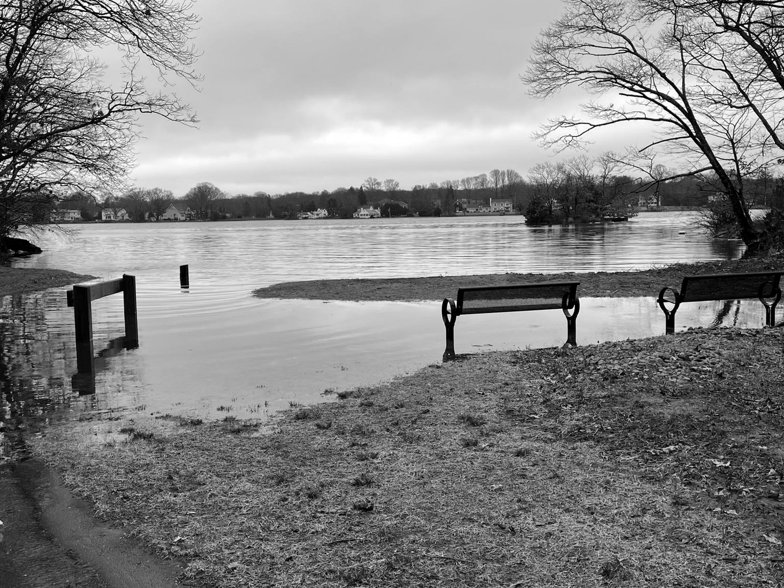
Rhode Island (RI) State Route 114 is a key north-south regional connector in the State’s East Bay transportation network that serves as the central main street for the communities of Barrington, Bristol, and Warren. The route provides important connections between commercial, educational, and residential land uses, and several local and state plans recognize that Route 114 also serves as a critical evacuation route. However, the long-term functionality of Route 114 is vulnerable to the current and future impacts of a changing climate, as the road runs through several low-lying areas along the RI shoreline. As recently as December 2022, several segments of the Route 114 corridor were underwater during a storm surge event (see Figure 1), with these conditions only expected to worsen in the future with increasing sea levels and more intense coastal storms (CRMC, 2018).
Even temporary disruptions to the use of this state-owned collector road can result in dramatic community impacts, ranging from disconnecting neighborhoods from emergency services to business closures and damage to critical infrastructure (URI, 2013). With support from the Rhode Island Division of Statewide Planning and the Towns of Barrington, Bristol, and Warren, the Route 114 Resilience Plan was developed to: (1) assess the current and future vulnerability of the Route 114 corridor through Barrington, Bristol, and Warren and (2) establish conceptual alternatives for reducing coastal flood risks and improving overall resilience in key areas of vulnerability (AOVs) throughout the region.


The primary goal of this plan was to engage local, regional, and state stakeholders in developing a purposeful and actionable plan that positions the Barrington, Bristol, and Warren communities to maximize the value of future investments that will be required to make the Route 114 corridor more resilient to future flooding. Recognizing the growing scale of funding opportunities that are now available for acting on addressing climate-related impacts, the focus of this plan is to prioritize actions that support long-term community goals and balance flood risk reduction with potential project costs to generate benefits that create value beyond coastal flood resilience.
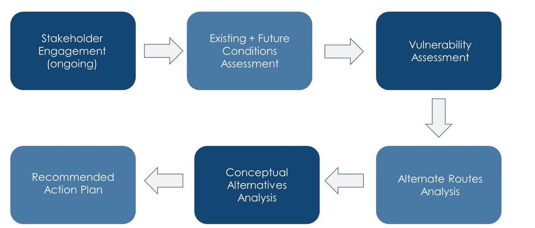
The planning process began in September 2023 with a kickoff meeting where the project team met with several members from the Project Management Team (PMT), which was comprised of representatives from the Rhode Island Division of Statewide Planning (RIDSP), Rhode Island Department of Transportation (RIDOT), Rhode Island Public Transit Authority (RIPTA), and the Towns of Barrington, Bristol, and Warren. During the meeting, attendees were introduced to the project and the following phased approach to the Route 114 Resilience Plan was established (see Figure 2).
The purpose of this initial phase was to use existing sources of data to develop an understanding of existing and future conditions related to flood risks within the Route 114 corridor through Barrington, Bristol, and Warren. As part of this assessment, the project team reviewed existing local and state plans, studies, programs, and Geographic Information System (GIS) datasets related to Route 114 and established several key areas of vulnerability (AOVs) for further examination during the vulnerability assessment.
During the second phase of the project, the project team assessed the vulnerability of key infrastructure to current and future flooding. This assessment consisted of developing composite risk scores that allowed for relative comparisons to be made between the vulnerabilities in each AOV with inputs for community stakeholders.
Building upon the results of the vulnerability assessment, an alternative routes analysis was conducted to determine scenarios and specific locations where Route 114 may become impassable due to flooding. The analysis also assessed where to divert traffic if necessary. Both short-term and longterm recommendations were developed to highlight where temporary diversions of traffic may be feasible and where more permanent alternative routes or adaptations may be needed in the future.
After completing the alternative route analysis, two conceptual alternatives were developed for each AOV that identify important strategies for addressing coastal flood vulnerabilities. Alternatives
were coupled with approximate ranges of costs for various actions, along with qualitative summaries of potential benefits and challenges (or “barriers”) to implementation.
Lastly, based on the results of the existing and future conditions assessment, vulnerability assessment, alternate routes analysis, and conceptual alternatives analysis, the Route 114 Resilience Plan compiled the outcomes of the previous planning phases into this planning document. This report serves as a preliminary action plan for use by the Towns of Barrington, Bristol, and Warren – along with other state agencies – to begin establishing projects aimed at improving the long-term resilience of the Route 114 corridor.

Stakeholder and community engagement was central to guiding the development of this plan. Stakeholders from the community, Town staff, and State agencies regularly joined meetings and workshops to identify coastal flood impacts, highlight key vulnerabilities, and recommend actions to reduce the risk of coastal flooding on Route 114.
Stakeholder engagement centered around three key activities:
• Monthly meetings with the PMT (see. p. 2), which was comprised of representatives from the Rhode Island Division of Statewide Planning (RIDSP), the Towns of Barrington, Bristol, and Warren, the Rhode Island Department of Transportation (RIDOT), and the Rhode Island Public Transit Authority (RIPTA)
• A series of six public community workshops hosted by members of the PMT to discuss project progress and solicit feedback following the completion of each planning phase (e.g., existing and future conditions assessment, vulnerability assessment, and alternate routes analysis)
• A public project website hosted by RIDSP with regular updates on project activities, publications of project materials, public workshop recordings, and information on how to engage with the project.

website: https://planning.ri.gov/planning-

“Use
real -time alerts as an early warning system when a storm is approaching.”


“Raise
the road out of the areas of vulnerability.”


Desktop Dataset Review
Existing Plans + Studies Assessment
Site Visits + Staff Meetings
Coastal Flood Assessment
During the first phase of the project, the project team collected and reviewing mapping data from datasets provided by the Division of Statewide Planning and the Towns of Barrington, Bristol, and Warren related to utilities, buildings, roadways, open space, zoning, historic properties, and land use. Additionally, important climate and transportation modeling was gathered from key state resources, including:
• STORMTOOLS – a mapping database that illustrates the extent and depth of flooding from sea level rise (see Figure 3) and coastal storms
• Sea Level Affecting Marsh Migration Model (SLAMM) – a geographic model that shows how coastal wetlands will likely transition and migrate onto adjacent upland areas under projected sea level rise scenarios of 1, 3, and 5 feet in the coming decades
The data collected was then combined into a geodatabase using GIS and used to generate existing and future conditions base maps highlighting key areas of vulnerability.
Importantly, this geodatabase was also used in subsequent phases of the project (e.g., the vulnerability assessment) where more granular analysis was needed to develop conceptual alternatives.

As a complement to the desktop dataset analysis, a plan review was conducted. This plan review involved the examination of existing plans, studies, maps, and reports from the Towns of Barrington, Bristol, and Warren (see Figure 4) and identified elements of those documents that mentioned actions, policies, priorities, and strategies related to Route 114 – especially those that focused on improving the overall resilience of the Route 114 corridor. The planning documents reviewed included:
• Past vulnerability assessments and community resilience reports
• Sea level rise reports
• Town hazard mitigation and flood management plans
• Town comprehensive plans
• Transportation fact sheets and parking studies
A summary of the complete list of planning documentation reviewed – in addition to the data reviewed as part of the desktop dataset review – is included in Appendix A of Attachment A (i.e., the Full Existing & Future Conditions Assessment). Additionally, key findings were summarized in the memoranda included in Appendix B of Attachment A, which were then used in the evaluation of existing and future conditions for key AOVs in each town.


Figure 4: Examples of plans reviewed from the Towns of Barrington, Bristol, and Warren as part of the Existing Plans and Studies Assessment

Over the course of November and December 2023, a series of site visits and interviews with planners from the Towns of Barrington, Bristol, and Warren were conducted to:
• Photo document (see Figure 5) existing conditions at each of the preliminary AOVs and visually confirm the conditions highlighted in the desktop dataset review
• Understand concerns – as well as short- and long-term visions – regarding the future of Route 114
• Brainstorm possible approaches to improving coastal flood resilience, including nature-based solutions, road raisings, hardened infrastructure, and other strategies
Additionally, a meeting was held with staff from the Rhode Island Department of Transportation (RIDOT) to learn about the Department’s plans for upcoming projects in the Route 114 corridor and approaches to evaluating and planning for resilience.


AOVs are areas along the Route 114 corridor in Barrington, Bristol, and Warren that the PMT identified as particularly vulnerable to the impacts of coastal flooding.
While conducting site visits and meeting with town staff and State agencies, the project team also reviewed the existing and future projected sea level and coastal storm scenarios for the State of Rhode Island. This included mapping the 10% and 1% annual exceedance probability (AEP) flood events (also sometimes referred to as the “10-year” and “100-year” flood events) for both the current and future 2-foot sea level rise (SLR) scenarios using data collected from STORMTOOLS.
WHAT IS ANNUAL EXCEEDANCE PROBABILITY (AEP)?
AEP is the probability (or chance) that a flood event of that magnitude will be met or exceeded within a given year. A storm causing coastal flooding with an AEP of 50% has a 1 in 2 chance of occurring at any point within a given year.
With the likelihood that storms will become more intense and frequent over time in Rhode Island as a result of climate change, it will become more common for storms to result in higher water surface elevations.
Sea level rise (SLR) is an important climaterelated hazard that will impact shorelines, estuaries, bays, and tidal rivers across Rhode Island. As the sea and mean tide levels rise, low points across the Rhode Island shoreline that were once above the intertidal zone will become inundated with tidal flood waters more frequently. To start, these nuisance tidal flooding events may only happen a few times per year. However, as SLR increases, these events will be more likely to occur monthly or even daily.
Storm surge flooding is a result of coastal storms that generate winds that push coastal waters towards land, which leads to a “surge” that increases water surface elevations (WSEs) above normal tides. When coupled with the tide, the maximum WSE reached during a storm event is often referred to as a “storm tide.” In Rhode Island, some of the most common types of storms include nor’easters and hurricanes. As SLR increases, a weaker storm in the future may still lead to the same (or greater) amounts of coastal flooding as a more powerful storm today.
The full coastal flood assessment is included in Appendix A of Attachment A as part of the Existing & Future Conditions Assessment. As shown in Appendix A , flood maps were prepared for each AOV to highlight the extent and depth of flooding, infrastructure and natural resources at risk of flooding, and an initial assessment of key challenges and opportunities for addressing mapped vulnerabilities.
Daily high tide flooding is the daily inundation of low-lying areas from high tide events. In Rhode Island, the coastline experiences two high tides and two low tides of roughly equal size each day.
Note: Mean higher high water (MHHW) refers to the average of the higher of the two high tides that occur each day.
The Federal Emergency Management Agency (FEMA) flood maps are an important component of the National Flood Insurance Program, as they serve as the foundation for establishing regulations and insurance requirements. However, FEMA flood maps are designed to assign insurance rates and rely on historic events (as opposed to future projected conditions). This makes it difficult to compare these maps with other types of flood maps like the coastal flood maps generated using STORMTOOLS in this assessment.
The 10% annual exceedance probability flood is a flood event that has a 10% chance of being equaled or exceeded each year.
The 1% annual exceedance probability flood is a flood event that has a 1% chance of being equaled or exceeded each year.
About the Vulnerability Assessment Climate Stressor Scenarios
Overall Vulnerability Scores by AOV

Following the completion of the existing & future conditions assessment, a vulnerability assessment was conducted to evaluate the transportation infrastructure, social, and cultural vulnerabilities within each AOV to current and future climate stressor scenarios caused by SLR and coastal storms (see next page). In collaboration with the PMT, quantitative frameworks for scoring each of these vulnerability dimensions were developed to generate vulnerability scores for each AOV.
The aim of developing these frameworks was to allow community stakeholders to make relative comparisons between the individual scores of transportation, social, and cultural vulnerabilities within each AOV – as well as to make relative comparisons across AOVs to prioritize future decision-making regarding any regional resilience planning related to Route 114.
The following pages briefly highlight the climate stressor scenarios used in the Vulnerability Assessment – along with the tabular summary of composite vulnerability scores for each AOV. For more details on the vulnerability assessment frameworks, summaries of the quantitative results, and example calculations, see Attachment B.


Excerpts from the Full Vulnerability Assessment shown in Attachment B
A climate stressor is an external change in climate that may cause damage to an asset (e.g., coastal storms and sea level rise). The following future tidal and storm scenarios were used to assess the vulnerability of assets within the AOVs:
High tide flooding is the daily inundation of low-lying areas from high tide events. In Rhode Island, the coastline experiences two high tides and two low tides of roughly equal size each day. Note: Mean higher high water (MHHW) refers to the average of the higher of the two high tides that occur in a given day. This stressor scenario incorporates the 2 feet (FT) of sea level rise (SLR) projected for the 2050s.
PROBABILITY FLOOD + 2 FT SLR
The 10% annual exceedance chance flood is a flood event that has a 10% chance of being equaled or exceeded each year. This stressor scenario incorporates the 2 FT of SLR projected for the 2050s.
PROBABILITY FLOOD + 2 FT SLR
The 1% annual exceedance chance flood is a flood event that has a 1% chance of being equaled or exceeded each year. This stressor scenario incorporates the 2 FT of SLR projected for the 2050s.


King tide flooding event at Mathewson Road (Barrington) on March 10th, 2024
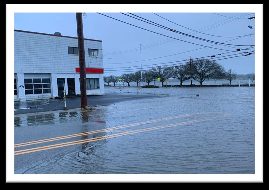

Coastal storm flooding at the intersection of Washington Street and Route 114 (Bristol) on January 10th, 2024 (similar flooding that would be expected from the current 10% storm event)
The following table – drawn from the Full Vulnerability Assessment included in Attachment B – summarizes the overall vulnerability scores for each of the AOVs. Those values highlighted with a darker red background show higher relative vulnerability scores.
Vulnerability scores for each AOV can be read across the rows to highlight what dimension(s) of vulnerability (e.g., transportation, social, and/or cultural) may be contributing most to the overall vulnerability score for a given AOV, while relative comparisons of vulnerability across AOVs may be made when comparing the scores within a given column.
For example, while each AOV demonstrated a degree of vulnerability to the climate stressor scenarios evaluated, the overall vulnerabilities of AOVs 6 and 5 were relatively higher than the other AOVs – driven largely by their higher scores for social and transportation vulnerabilities.
Importantly, these scores are not intended to be interpreted in a way to prioritize one AOV over another. As indicated by the scorings and note above, all seven AOVs along Route 114 represent areas vulnerable to coastal flooding scenarios and a range of vulnerability types (i.e., transportation, social, and cultural vulnerabilities).
About the Alternate Routes Analysis Short-Term Detours Long-Term Detours
After completing the vulnerability assessment, an alternate routes analysis was completed to evaluate the coastal flood scenarios that may cause short- and long-term detours within each AOV along Route 114. As part of the analysis, alternate routes were then proposed as recommendations for diverting traffic around these closures.
The coastal flood scenarios used in this analysis included the following present-day and future coastal floods:
Present-day
• 10% annual exceedance probability (AEP) flood with no SLR,
• 1% AEP flood with no sea level rise (SLR) Future
• Mean higher high water (MHHW) with 2 feet of SLR, and
• 10% AEP flood with 2 feet of SLR
Detour routes were determined by consulting the plans and studies previously reviewed as part of existing & future conditions assessment (e.g., RIDSP Sea Level Rise Transportation Analysis, municipal hazard and flood mitigation plans) and analyzing the existing road network and travel demand models provided by RIDSP. The Full Alternate Routes Analysis memorandum can be found in Attachment C. Additional State hurricane evacuation maps are included in Attachment E. Brief summaries of the short- and long-term detours are provided in the pages that follow.
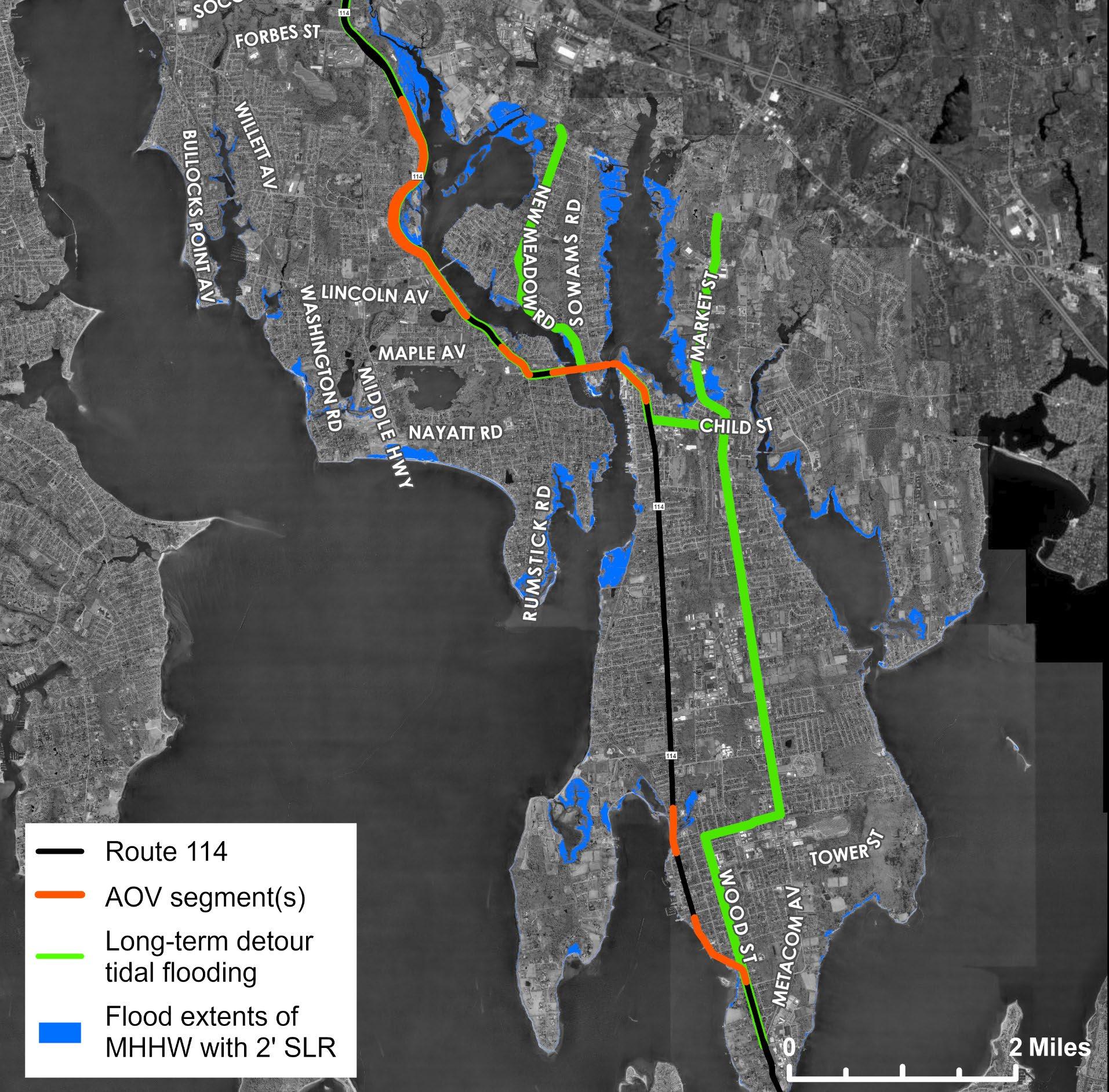
The short-term detours identified in the alternate routes analysis were specific to each AOV and were designed to bypass flooding caused by the current 10% AEP and 1% AEP coastal flood in each AOV. These coastal flood scenarios represented two types of less probable but higher-impact coastal storm events.
In some instances, detours were extensive as there were no viable paths to re-route back onto Route 114 due to the extent of the projected flooding throughout the AOV caused by the modeled coastal storm events. In other instances, detours routed out of Rhode Island into neighboring areas in Massachusetts.
The short-term detours identified in the analysis were not intended to serve as permanent diversions away from Route 114. Instead, they highlighted viable routes to be used in the event of storms equaling the extent of flooding impacts caused by the current 10% and 1% AEP coastal storm events. In many cases, the short-term detours mirrored the existing evacuation routes that remain unaffected by flooding in the areas under consideration, and as noted in the full analysis (see Attachment C), many of the short-term detours also required advance evacuation to keep affected community members out of flooded areas.
Several AOVs contained Rhode Island Public Transit Authority (RIPTA) bus stops that would also be impacted by the short-term detours proposed. Additional coordination with RIPTA would be needed when short-term detours are implemented to ensure continued service before and after flooding events.


Excerpts Showing Short-Term Detours from the Full Alternate Routes Analysis provided in Attachment C
In addition to the short-term detours, two long-term alternate route maps were generated, displaying long-term detours that avoid modeled flooding related to the mean higher high water (MHHW) with 2 feet of SLR scenario and the 10% AEP coastal storm event with 2 feet of SLR.
Similar to the short-term detours, several of the longterm detours proposed in the analysis were extensive, as connections back to Route 114 were not feasible due to the extent of flooding modeled in the MHHW + 2 feet of SLR and 10% AEP + 2 feet of SLR scenarios. This analysis also included recommendations to route several of the long-term detours north into Massachusetts. As noted earlier, this will likely require additional coordination with not only MassDOT but also several Massachusetts municipalities bordering Rhode Island.
Unlike the short-term detours, these long-term detours represent a significant change to existing travel patterns across Barrington, Bristol, and Warren, as travelers adjust to the increasing likelihood of higher-impact storm events and daily nuisance flooding caused by sea level rise.


Excerpts Showing Long-Term Detours from the Full Alternate Routes Analysis provided in Attachment C
About the Conceptual Alternatives Conceptual Alternatives by AOV
After completing the vulnerability assessment and alternate route analysis, the results were shared with members of the PMT and Barrington, Bristol, and Warren communities. Toward the end of October 2024, members of the project team and PMT hosted two public workshops to present findings and solicit input from the community on the range of actions that should be considered for reducing the risks of coastal flooding within each AOV along Route 114 under two future scenarios (see Attachment D for a tabular summary of community inputs):
• Mean higher high water (MHHW) + 2 feet SLR (i.e., future high tide flooding)
• 1% AEP flood + 2 feet SLR (i.e., future higher-impact coastal storm flooding)
These risk reduction scenarios were selected based on direction from PMT members to bookend the range of alternative strategies considered – from preliminary actions largely targeted at reducing the risk from future tidal flooding (“Scenario A – Lower Risk Reduction Alternatives”) to “higher-hanging fruit” or more ambitious actions aimed at reducing the risks of Route 114 to the 1% AEP coastal storm + 2 feet SLR (“Scenario B – Higher Risk Reduction Alternatives”).
The following conceptual plans highlight several of the key strategies identified by not only community members but also members of the larger project team and PMT.

“We should build berms along the coast to reduce flooding.”

“We will need ways to evacuate safely and quickly during large flooding events”


According to the modeling from STORMTOOLS, flooding from the future projected MHHW + 2 feet SLR is not expected to inundate Route 114 within this AOV. However, even under current conditions, community observations have indicated that large tidal events (e.g., king tides) can cause floodwaters to reach close to the northbound lane adjacent to the Barrington River.
To reduce the risks of these potential impacts from future, large tidal flooding events, Concept A for AOV 1 includes the installation of permanent water level sensor and establishment of an early warning system to notify local community members, travelers, and RIPTA of these periodic tidal flooding events that may require temporary road closures along the northbound lane of Route 114 in the future.
EST. RANGE OF COSTS: $250,000 to $500,000
While this action represents an early, “low hanging fruit” solution for mitigating future potential tidal flood risks, it can also pay dividends in higher risk reduction strategies (see next page), as it can be used to help communicate anticipated impacts related to larger, future coastal storm events (e.g., the future 1% AEP coastal storm) as well.
One challenge with implementing an early warning system is that it will require residents and businesses to sign up for messages. However, the Town’s existing CodeRED emergency notification systems could be leveraged to help notify residents of tidal flooding issues when present. RIDOT, RIPTA, and the Town will also need to coordinate with responsible parties in the community (e.g., the Department of Public Works) to put out messages warning community members of the risks and necessary detours – in addition to notifying community members when it is safe to use the roadway again following a flood event. However, there may also be opportunities to partner with local groups (e.g., the Ocean Climate & Coastal Systems Research Group) that are working to establish sensor networks in Rhode Island around ocean dynamics that may be integrated into early warning systems.

Under the modeled, future 1% AEP coastal flooding conditions, flood depths along Route 114 within this AOV are projected to reach up to 10 to 12 feet (see the Full Existing & Future Conditions Assessment in Attachment A), making the entire stretch of road impassible. While the idea of elevating the entirety of Route 114 through this area was initially raised and discussed by members of the PMT and community during project workshops, it was dismissed from further consideration given concerns over the feasibility and cost of pursuing such an alternative. It was recognized that an elevated roadway would need to extend into East Providence (to the north) to tie into necessary elevations, and a benefit-cost analysis (BCA) was unlikely to show cost-effective results necessary for securing large, federal funding to support the project.
In lieu of a conceptual plan suggesting the future elevation of Route 114 within AOV 1, this alternative concept suggests:
• Installing sheet pile cutoff walls along one or both sides of Route 114 (northbound and southbound) to help stabilize the inundated portion of Route 114 and prevent washout during large storm events
EST. RANGE OF COSTS: $5-10 million
• Replacing the bus stop shelter near the entrance to Osamequin Nature Preserve with a metal structure able to withstand periodic inundation from salt water (e.g., 316 stainless steel) and completing a study to further investigate evacuation routes and determine the investments that may be needed to add capacity to the existing roadway networks and ensure that the alternate routes identified in the Full Alternate Routes Analysis (see Attachment C) can be used effectively during large future storm events
EST. RANGE OF COSTS: $525,000 to $775,000
Implementing these strategies may improve future evacuations and the long-term resilience of Route 114 by helping this portion of the roadway bounce back more quickly after large, future coastal storm events. However, these actions are not aimed at preventing flooding from larger, future coastal storms.

Similar to AOV 1, future tidal flooding caused by the MHHW + 2 feet SLR is not projected to inundate Route 114 within AOV 2. However, the extent of the future modeled tidal flooding does encroach on several areas along the eastern edge of the road (i.e., the side abutting the Barrington River) – including the areas near Prince Pond and the RIDOT Park & Ride (near the Barrington Congregational Church).
To reduce the risks from these impacts, this conceptual plan suggests that the following actions be taken:
• Establish a 2.5- to 3-foot elevated berm around the RIDOT Park and Ride parking lot in coordination with the Barrington Congregation Church, which is currently leasing the property to RIDOT. This will help extend the use of this parking lot and reduce the risks from daily high tide flooding in the future.
EST. RANGE OF COSTS: $1.0-1.4 million
• Work with local residents to consider establishing a voluntary buyout program for several of the residential properties along the Barrington River likely to be impacted by future tidal flooding and restoring the land for use as interim tidal flood mitigation along most of the Route 114 roadway segment through this AOV.
In addition to berming the RIDOT Park and Ride to reduce the risk of future tidal flooding, opportunities to establish an agreement with the Barrington High School could be explored to allow for the temporary use of the High School parking lot when the RIDOT lot is overrun with coastal flood waters from larger, future storm events. This temporary usage could be triggered by public safety officials in coordination with the Superintendent of Schools.
It can be difficult to gain support from local residents for voluntary buyouts, and the process can be expensive. However, in the case of this AOV, if buyouts of several of the contiguous properties along the Barrington River were possible, it could allow for the restoration of the natural floodplain in this area, which can serve as an added buffer against future tidal flooding.

In AOV 2, coastal flooding from the future 1% AEP coastal flood event is projected to result in 12+ feet of water on Route 114, cutting off travel along this segment of the roadway. Initially, members of the PMT and community raised the idea of looking at ways to cut off the coastal flood pathway to Prince Pond in the southern portion of this AOV. This would require modeling the potential benefits of redesigning the culvert/crossing in this area and incorporating additional flood control infrastructure (e.g., tide gates, new flood walls, and pumps). However, it was recognized that floodwaters from the future 1% AEP coastal storm were still likely to inundate Route 114 via pathways east of the Barrington High School and around the Barrington Veterans Memorial Bridge.
As an alternative strategy, this conceptual alternative proposes that Barrington:
• Install sheet pile cutoff walls along one or both sides of Route 114 (similar to those proposed in Concept B for AOV 1) from the area north of the Barrington Veterans Memorial Bridge to Princes Hill to provide stability and added resilience to the inundated portion of Route 114, and ultimately help prevent washout during large storm events.
EST. RANGE OF COSTS: $2-4 million
• Further examine the existing evacuation routes and determine the investments that may be needed to add capacity to the existing roadway networks and ensure that the alternate routes identified in the Full Alternate Routes Analysis (see Attachment C) can be used efficiently during large future storm events –especially to evacuate the Barrington High School.
EST. RANGE OF COSTS: $500,000 to $750,000
Note: While this plan is focused on the long-term resilience of Route 114 to coastal flooding, Barrington High School is planning to undergo significant and costly renovations over the coming years. As a complement to this conceptual plan, the Town may also want to consider interim actions (e.g., investing in building-level floodproofing and temporary flood barriers) to reduce the risk of the school to higher probability, less intense future coastal storm events (e.g., 10% AEP coastal storm with 2 feet SLR).

The modeled extent of future tidal flooding is not expected to inundate any portions of Route 114 in AOV 3. Most of the potential impacts from tidal flooding are limited to some of the residential properties abutting the Barrington River.
While no immediate actions to reduce the risks from future tidal flooding are proposed as part of this concept, Concept A advocates for better understanding the complexity of combined coastal and pluvial* flood effects in this area by modeling the compounding impacts from pluvial flooding coming from the west of the AOV (i.e., behind the Barrington Shopping Center).
EST. RANGE OF COSTS: $400,000 to $600,000
While this plan is centered on addressing impacts from coastal flooding on Route 114, it was discovered during the initial site assessments, and in discussions with Town staff and local community members, that future flood risks in this area were not limited to the impacts caused by coastal flooding. There were similar concerns for stormwater flooding impacts as well.
Concept A proposes taking a holistic look at modeling the potential impacts of both coastal and pluvial flooding to fully assess the suite of alternatives needed to address flooding impacts to Route 114 and the surrounding area (e.g., risk of inundation of access roads like Maple Ave).
*Pluvial flooding occurs when intense rainfall overwhelms the ground's ability to absorb water or the capacity of urban stormwater drainage systems. This excess water then flows overland, accumulating in low-lying areas and causing flooding. It's a common type of flooding, particularly in urban areas with extensive impervious surfaces like roads and buildings.

The future 1% AEP coastal flood extent is projected to inundate a 1,800-foot segment of Route 114 within this AOV, with maximum flood depths reaching 8+ feet. Under these conditions, not only would Route 114 become impassible, but it would be similarly infeasible to access many residential properties and the Town’s key commercial shopping area.
As suggested in the conceptual plan on the previous page, pluvial flooding may compound the overall flooding impacts in this area and require that additional measures be taken to reduce the risk from modeled stormwater impacts. However, this conceptual plan proposes that voluntary buyouts of a few residential properties be leveraged to construct a 12+ foot elevated flood wall, with a flood gate and pump station, across the inlet between Markwood Dr and Riverside Dr to cut off the coastal flood pathway to Route 114 created by the 1% AEP coastal storm + 2 feet SLR.
EST. RANGE OF COSTS: $15-20 million
A major challenge with implementing this concept is that it hinges on voluntary buyouts of at least four residential properties along Markwood Dr and Riverside Dr. These buyouts would be needed to establish the space necessary to install the flood wall for cutting off the coastal flood pathway in this scenario. Voluntary buyouts can be difficult to establish with private property owners; however, as suggested in Concept A for AOV 2, if this is a flood risk reduction alternative that the Town would like to pursue, starting conversations early with members of the community can help establish buy-in.
Note: Additional solutions for addressing the combined impacts of coastal and pluvial flooding may be identified during the Town’s development of the Mussachuck Creek Corridor Plan and should be considered in connections to the actions proposed in this conceptual plan.

The projected future tidal flood extents from STORMTOOLS show that during daily tidal events (MHHW + 2 feet SLR) floodwaters come close to the eastern and western approaches to the Barrington Bridge. While the modeled conditions do not indicate overtopping under this scenario, during larger tidal events (e.g., king tides) (see Figure 6), community members did express concerns that the roadway could become prone to flooding – especially in the areas near the approaches to the Barrington Bridge.

Figure 6: Photo of king tide flooding on November 16, 2024 along Mathewson Rd just south of AOV 4 (Photo credit: Barbara Green via MyCoast)
Similar to Concept A for AOV 1, to reduce the risks of these potential impacts from future tidal flooding events, this conceptual plan proposes the installation of a permanent water level sensor and the establishment of an early warning system to notify local community members and travelers of periodic, large tidal flooding events that may require temporary road and bridge closures along Route 114 in this area. This system could include making better use of the Town’s existing CodeRED emergency notification systems to help notify residents of tidal flooding issues when present. EST. RANGE OF COSTS: $250,000 to $500,000

The modeled extent of the future 1% AEP coastal flood impacts significant portions of Route 114, extending outward from the Barrington Bridge approaches on both sides of the Barrington River and cutting off Tyler Point. These conditions would make travel along Route 114 infeasible and limit the options for implementation measures that would prevent flooding along Route 114 without considering a costly, area-wide risk reduction action (e.g., elevating Route 114 through AOVs 4 & 5 and installing flood control structures on the Barrington and Warren Bridges – an alternative that was ruled out upon further consultation with members of the PMT).
As such, this conceptual plan proposes that the following actions be taken to reduce the risks caused by flooding under this scenario:
• Further examine local evacuation routes and determine investments that may be needed to add needed capacity to the existing roadway networks north of Tyler Point and ensure that the alternate routes identified in the Full Alternative Routes Analysis can be utilized effectively during large future storm events.
EST. RANGE OF COSTS: $500,000 to $750,000
• Install sheet pile cutoff walls along an approximately 1,500-foot section of Route 114 on both sides of the Barrington Bridge to help stabilize the inundated portion of Route 114 and prevent washout during large storm events.
EST. RANGE OF COSTS: $2-$3 million
While these actions would help enable easier evacuation of vulnerable flood areas within this AOV and recovery of the roadway following a large, future coastal storm event, these strategies will not prevent Route 114 from flooding from the 1% AEP coastal storm + 2 feet SLR.


The modeled results from STORMTOOLS do not show future tidal floodwaters overtopping Route 114 with 2 feet of SLR; however, future MHHW flood extents are expected to encroach daily in the area near the eastern approach to the Warren Bridge, putting the approach at risk during larger future tidal events (e.g., king tides). To mitigate these risks, this conceptual plan includes:
• Installing an ~200-foot elevated berm up to 2 feet high along the north side of the eastern approach to the Warren Bridge to provide additional freeboard above the existing elevation of the bridge approach and reduce the risks from larger, future tidal events
EST. RANGE OF COSTS: $1-$2.5 million
• Establishing an early warning system (using permanent water level sensors) –potentially increasing the uptake of the Town’s existing CodeRED system – that can be used to notify residents and businesses in the future to make use of alternative routes to re-route around short-term detours south of the bridge caused by periodic, large tidal flooding events
EST. RANGE OF COSTS: $250,000 to $500,000
A challenge posed by this conceptual plan is that Route 114 would remain vulnerable to larger coastal storm events (see next page). Similarly, a challenge identified with implementing the early warning system is that it will require residents and businesses to sign up for the messages – and the Town would need to coordinate with responsible parties (e.g., the Department of Public Works) to put out messages warning community members of the risks and clearly identifying alternative routes in both English and other languages most commonly spoken by residents in this area (e.g., Portuguese).

The future 1% AEP coastal flood is projected to impact a significant stretch of Route 114 within AOV 5. As shown in Attachment A, flood depths are expected to reach 13 feet or more along some areas of the road.
Proposed strategies for addressing these risks along this portion of Route 114 are limited but include:
• Studying existing evacuation routes to determine if any investments are needed to add capacity to the surrounding roadway network and ensure that the alternate routes identified in the Full Alternative Routes Analysis (see Attachment C) can be easily utilized as needed during a large, future storm event to re-route travel south out of downtown Warren
EST. RANGE OF COSTS: $500,000 to $750,000
• Temporarily deploying road closure and detour signs – along with early warning communications – during large future storm surge events to help facilitate efficient evacuations and direct travelers to alternate routes
EST. RANGE OF COSTS: $250,000 to $500,000
Overall, applying these strategies will help divert traffic from the flooded portion of Route 114, and vehicles and community members are less likely to become stranded during large future coastal flood events. However, this alternative concept also presents some significant challenges, as the extent of the detours to alternate routes would be much greater during larger storm events, and costly infrastructure investments may be needed to improve the capacity of the surrounding roadway network to periodically handle larger amounts of traffic flow during evacuations.
Additionally, as an interim strategy, the Town may also want to explore the potential for public-private partnerships to reduce the risk of other key vulnerable community facilities along Route 114 (e.g., Mobil station at 100 N Main St) to higher probability, less intense future coastal storm events (e.g., 10% AEP coastal storm with 2 feet SLR) using temporary flood barriers.

With 2 feet of additional SLR (beyond current conditions), the flooding from MHHW (i.e., daily tidal flooding) is projected to cause up to a foot of overtopping in the area near the Silver Creek crossing. This would cause daily nuisance flooding, which would only be exacerbated by larger tidal events (e.g., king tides) and future coastal storms.
Proposed strategies for mitigating these risks as part of this conceptual plan include:
• Elevating a relatively small portion(approximately 250 feet) of Route 114 adjacent to the Silver Creek crossing by 2-3 feet
EST. RANGE OF COSTS: $1.5-$3 million
• Study and reevaluate the sizing of the existing culvert to appropriately address related tidal flooding concerns and the need for adequate tidal flushing in Silver Creek, which may eventually require the upsizing of the culvert diameter and installation of a new adjustable tide gate
EST. RANGE OF COSTS: $500,000
While these proposed strategies would help reduce the risk of future tidal flooding along this stretch of Route 114 and ultimately yield potential water quality benefits in Silver Creek by improving future tidal flushing, elevating this portion of the road is likely to require the realignment of adjacent driveways and parking lots and regrading of local roads (e.g., Washington St.) to meet the new elevations of the elevated Route 114 segment. Actions like these would require temporary roadway closures during construction and coordination with local businesses and residents to reroute traffic along short-term detour routes (see Attachment C).
Note: The US Army Corps of Engineers is also in the process of conducting a flood study – the results of which may lead to additional strategies for improving the long-term resilience of the Silver Creek crossing and surrounding area. These strategies should be taken into consideration in future discussions related to implementing actions for reducing future coastal flooding in this AOV.

The modeled future 1% AEP coastal flood is projected to inundate areas of this AOV with up to 12+ feet of water, causing major disruptions to travel along Route 114 and area-wide impacts to the Silver Creek drainage area. To reduce the risks from this potential coastal flooding event, the following actions could be pursued in the future:
• Similar to Concept B for AOV 5, commission a more detailed engineering study of evacuation routes to determine the investments that may be needed to add capacity to the existing roadway networks and ensure that the alternate routes identified in the Full Alternative Routes Analysis (see Attachment C) can be effectively used during large future storm events to re-route travel out to Sherry Ave.
EST. RANGE OF COSTS: $500,000 to $750,000
• Install water level sensors near the Silver Creek crossing to monitor local water surface levels and use data to provide early warning communications to nearby businesses and residents in advance of larger, future storm events to make sure that evacuations, detours, and road closures can be coordinated – in addition to notifying community members when it is safe to return.
EST. RANGE OF COSTS: $250,000 to $500,000
• Install sheet pile cutoff walls along an approximately 2,500-foot section of Route 114 to help stabilize the inundated portion of Route 114 (and prevent washout during large storm events) and relocate the metal RIPTA bus stop shelter near the intersection with Creek Ln. out of the area of inundation to the north or replace it with a signpost stop (similar to the other RIPTA bus stops in this AOV).
EST. RANGE OF COSTS: $1.5-3 million
While these actions would allow north-south travel around the area of inundation, they would not provide area-wide risk reduction to the areas surrounding Silver Creek, including the areas currently occupied by Guiteras Elementary, Silver Creek Rehab and Healthcare Center, and Bristol VFW Post 237. However, implementing these strategies may improve the long-term resilience of Route 114 and help this portion of the roadway bounce back more quickly after large, future coastal storm events.

Modeled future tidal flooding extents do not encroach on this portion of Route 114. However, this AOV is vulnerable to higher probability future storm events (e.g., future 10% AEP flood + 2 feet SLR) and king tide events. Tidal floodwaters regularly come up against the existing seawalls along Route 114 in this AOV – especially in the areas near the intersections with Burton St. and High St.
To reduce the risks from larger, future tidal flooding events, the following actions are proposed as part of this conceptual plan:
• Install a temporary flood barrier (e.g., a deployable stop log flood barrier) designed and installed to bridge the gap in the seawall along Route 114 near Walker Creek, which is currently used as a boat ramp and for boat storage. This temporary barrier could be deployed when needed but removed afterward to continue to provide access to the boat launch following larger future tidal flooding events.
Regularly maintaining the existing seawalls and deploying a temporary flood control structure would help reduce the risks of coastal impacts to Route 114 from future tidal and higher probability future storm events (e.g., future 10% AEP flood + 2 feet SLR) – in addition to reducing risks to the properties adjacent to Route 114. However, the use of a stop log flood barrier would require the assignment of a responsible party (e.g., Bristol DPW) and the establishment of a standard operating procedure to ensure the panels are regularly inspected/maintained and are deployed/removed in a timely fashion.

The future 1% AEP coastal flood extents are projected to inundate portions of Route 114 and the surrounding areas in this AOV with maximum flood depths of up to 14+ feet. To reduce risks from these potential impacts, this conceptual plan suggests implementing a suite of actions designed to work in conjunction:
• Build an elevated berm up to approximately 14 feet high along the eastern portion of Route 114 from the corner of High Street and Walley Street to the high point between Fairview Drive and Griswold Ave. to reduce the risks from higher-impact, future coastal storms to critical Town facilities (e.g., Bristol Water Treatment Facility) and residential properties to the north of the berm.
• Install a gated flood barrier across Wood Street that ties into the elevated berm and could be deployed during larger, future coastal flood events.
• Leverage voluntary buyouts over time in partnership with local residents to purchase the residential properties along the inland side of Route 114 needed to provide the space necessary to build an elevated berm.
While these actions would not reduce the risk of flooding along Route 114 during the future 1% AEP storm event in this AOV, they are intended to allow for the use of Wood Street during future short-term detours/evacuations and provide more areawide risk reduction – especially to the Town Water Treatment Plant. However, this proposed conceptual alternative may be challenging to implement, as it would require additional coordination between the Town and RIDOT, voluntary buyouts of residential properties, and realignment of driveways. It is also likely to impact three properties within the Bristol Historic District. Similar to Concept A for AOV 7, it would also require the assignment of a responsible party (e.g., Bristol DPW) and the establishment of a standard operating procedure to ensure the flood barrier across Wood St is regularly inspected and maintained – and is deployed in a timely fashion.
While the conceptual plans presented above represent a range of actionable strategies for reducing Route 114 risks from current and future coastal flooding, several actions can be taken now to begin implementing meaningful risk reduction measures. These actions include:
Implement several of the less costly actions identified in many of the Concept A plans that do not require the same level of investment to yield immediate benefits to the community. These include:
• Install water level sensors and establish early warning communications systems that notify residents of flood hazards and how to safely avoid inundated portions of Route 114 using alternate routes.
• Commission additional studies (as needed) to better understand the combined impacts of coastal and stormwater flooding (where applicable) and the need for any additional investments in the roadway networks surrounding Route 114 to increase capacity and more efficiently evacuate.
• Begin conversations with private property owners who are interested in exploring options to establish voluntary buyout programs that may enable more ambitious restoration and flood risk reduction projects.
While this plan was generously supported by a Technical Assistance Grant from the RI Division of Statewide Planning, other grant mechanisms should be explored to unlock additional funding aimed at supporting the implementation of additional actions. These could include (but are not limited to) the following grant programs:
• US DOT, Promoting Resilient Operations for Transformative, Efficient, and Costsaving Transportation (PROTECT)
• FEMA, Building Resilient Infrastructure and Communities (BRIC) Program
• NOAA, Climate Resilience Regional Challenge
See Attachment F for a more extensive list of potential funding mechanisms that have been utilized by other communities to implement actions similar to those incorporated in this plan. Note: The list of funding programs includes those that exist as of February 2025. The availability of funding programs, application deadlines, and requirements vary. It is best to consult the funding program pages for the latest information.
To ensure that the plan remains actionable over time and serves as a living roadmap for improving the resilience of Route 114, a governance structure should be established in each town to oversee the prioritization and implementation of actions over time. Steps in this process could include:
• Bring the conceptual plan alternatives before the Town Council to decide who will guide the implementation of the specific actions.
• Establish a method for prioritizing actions based on community goals that may stretch beyond improving the resilience of Route 114 to coastal flooding. This method for prioritizing actions may incorporate priorities related to economic development, accessibility, public health and safety.
Recognizing that many of the longer-term actions proposed in this plan (e.g., road raisings, flood berms, voluntary buyout programs) will require local and regional coordination, starting now, it would be useful to:
• Share this action plan widely with others in the East Bay community.
• Develop a regional working group (or leverage an existing group) to continue conversations with important state agencies like the RIDOT on long-term coastal resilience planning.
• Continue to make intentional connections between this plan and other longterm planning efforts led by State agencies (e.g., RIDOT Resilience Improvement Plan) and established town committees/groups (e.g., Planning Board, Resilience and Energy Committee, Economic Development Committee, Bicycle-Pedestrian Advisory Committee, Conservation Commission).
5. Conceptual Alternates | 40

February 2024


The area that defines AOV 1 extends from the East Providence-Barrington border to an area south of the East Bay Health Center. This area contains natural resources of significance that offer ecological and community services to the Town of Barrington. This includes walking trails, shoreline areas, and bird sanctuaries in Osamequin Park and Walker Farm, which are also located in existing FEMA flood zones and areas at risk of exposure to a Category 1 hurricane, as indicated in the Town’s Hazard Mitigation Plan (Jacobs, 2022). Similar flood risks are projected to impact low-lying vulnerable areas in this AOV, such as the portion of Route 114 adjacent to the Barrington Community Garden.
Future projections estimate that 3 feet of SLR will inundate the road with 12 feet of water in areas during a 1% annual chance flood event. Such an event would have major implications on public safety, disruption of services, and potential economic loss. The Hazard Mitigation Plan also identified at-risk critical facilities, including the Barrington Christian Academy, Primrose Hill School, and the East Bay Health Center, each of which is vulnerable to intense hurricanes (Category 3 and 4).
2. Existing + Future Conditions
Under current conditions, the 10% annual chance flood event threatens natural resources, residential properties, and evacuation routes along Route 114 in AOV 1.
Current flooding conditions in AOV 1 present flood risks to various portions of Route 114. Tidal flooding drives coastal flooding and inundation along the shoreline areas, including valuable natural resources (e.g., Walker Farm).
Areas vulnerable to nuisance flooding (i.e., tidal flooding events) extend from St. Andrews Farm south beyond Primrose Hill Road. Within this area, flood waters have the potential to reach and impact numerous
Tidal Flooding (MHHW) in 2023
10% Annual Chance Flood in 2023
1% Annual Chance Flood in 2023

Sources: RIGIS, CRMC, Town of Barrington
residential properties, as well as a sewer pump station.
During a 1% annual chance flood, the flood extents spread westward and are likely to impact more residential properties and critical services such as the East Bay Health Center and RIPTA bus stops. Furthermore, increased portions of Route 114 become impacted by flooding and could become impassable depending on the depth and duration of flooding.
By 2050, several Barrington schools and health centers in AOV 1 may be vulnerable to flooding impacts during a 1% annual chance flood event, while the extent of a 10% annual chance event will impact more residential areas.
According to the NOAA Sea Level Rise Viewer (NOAA, 2023), the Town of Barrington is projected to face 2 feet of SLR by the 2050s. The anticipated impacts of sea level rise on coastal flood events will increase flood-related risks in AOV 1.
By the 2050s, the entirety of Walker Farm will be impacted by nuisance flooding. Future nuisance flooding will inundate a majority of the coastal area in AOV 1, with tidal flood waters extending close to Route 114.

During the future 10% annual chance flood event, nearly all of Route 114 within AOV 1 will be impacted by flooding. Additionally, the flood extents will cover St. Andrews Farm, the residential properties on Pinetop Road, and all of Walker Farm to the south.
During the future 1% annual chance flood event, the flooding extent will expand to include parts of the Primrose Hill neighborhood and the area around the Barrington Christian Academy.
Tidal Flooding (MHHW) + 2 Feet of SLR
10% Annual Chance Flood + 2 Feet of SLR
1% Annual Chance Flood + 2 Feet of SLR
Sources: RIGIS, CRMC, Town of Barrington
Based on current SLR predictions, coastal water depths in AOV 1 are predicted to cause up to 12 feet of flooding along portions of Route 114 during a future 1% annual chance flood event.
The 1% annual chance flood + 2 feet of SLR has been recommended by Spaulding et al. (2018) as the STORMTOOLS design elevation (SDE) for use in assessing the impact of future sea level rise and climate action planning. Based on the projected water depths for this scenario, many key services in AOV 1 will be inaccessible due to coastal flooding.
The Osamequin Nature Preserve and Walker Farm, situated directly on the Barrington River shoreline, will likely be inundated by more than 10 feet of water.

Sources: RIGIS, CRMC, Town of Barrington
On the upgradient side of Route 114, the Barrington Christian Academy and East Bay Health Center will see some coastal flooding, with a few feet of water flooding the property. While not as significant as the flooding experienced elsewhere in AOV 1, these flood depths may still make it challenging for pedestrian and vehicular traffic to retreat from these locations. Additionally, access to both buildings via Route 114 will not be possible due to the depth of flooding (>10 feet) in the surrounding area. The Barrington Early Childhood Center and Primrose Hill School will not be impacted by coastal flooding in this scenario, but they would face similar challenges with roadway access from Route 114. Similarly, several RIPTA bus stops would not be serviceable, and RIPTA would likely need to reroute buses from Route 114.

AOV 1 contains a large complex of mapped freshwater and estuarine/marine wetlands surrounding the Route 114 corridor based on geographic data provided by the Rhode Island Department of Environmental Management (RI DEM) and the National Wetlands Inventory (NWI). The majority of the Route 114 corridor in the AOV also falls within mapped natural heritage areas. Projected conditions indicate that flood depths in these areas could reach greater than 10 feet during the 1% annual chance flood event with 2 feet of SLR. This would have a significant impact on the natural resources present. The ability of natural resources to help mitigate flood risks in this area is likely to decrease over time as the projected amount of inundation increases and outpaces the rate at which the natural resources can adapt.
LEGEND
1% Annual Chance Flood + 2 feet of SLR

Freshwater Wetland

Estuarine/Marine Wetland

Natural Heritage Areas
Sources: RIGIS, RIDEM, CRMC

By the 2050s, it is projected that 129 buildings within AOV 1 will be at risk of inundation during a 1% annual chance flood event + 2 feet of SLR. Most of the buildings at risk of flood-related impacts are residential properties located on side streets adjacent to Route 114. Fortunately, many of these neighborhoods have secondary egress routes, which could be used in the event of an evacuation without leaving residents stranded. The exception to this would be the homes on Peck Lane, which rely on Route 114 for access.
Of additional concern are the institutional buildings vulnerable to a 1% annual chance flood event with 2 feet of sea level rise, which includes the Barrington Christian Academy and East Bay Health Center (Figure 6). While both structures will be impacted by flood waters, secondary egress via Old County Road would allow safe access by emergency vehicles during flooding events.

1% Annual Chance Flood + 2 feet of SLR
Commercial (0 buildings)
Commercial/Residential Mixed (0 buildings)
Residential (125 buildings)
Manufacturing/Light Industrial (0 buildings)
Municipal/Institutional (4 buildings)
Sources:

One of the key challenges in AOV 1 is the extent of inundation under current and future conditions. By the 2050s, nearly the entirety of Route 114 within this AOV is likely to be inundated by flood depths of up to 10 feet during a 1% annual chance flood event. These conditions would limit safe vehicular or pedestrian travel and make it difficult to elevate Route 114 to heights necessary to avoid overtopping. Additionally, valuable natural resources in this area (e.g., the Osamequin Nature Preserve – see Figure 7) are likely to lose their ability to provide natural flood risk mitigation and protect sensitive coastal ecosystems over time due to coastal inundation.
Existing natural resources and parks within AOV 1 present the opportunity to use nature-based solutions and floodplain restoration methods to reduce near-term flooding concerns along the Barrington River shoreline in the Hundred Acre Cove. Implementing nature-based solutions aimed at reducing coastal erosion, reducing/buffering tidal and event-based wave energy, and improving floodplain storage may reduce the impacts on residential and institutional infrastructure west of Route 114 (e.g., the Barrington Early Childhood Center). The Town could also consider rerouting Route 114 (as needed) to a higher elevation roadway (e.g., Middle Highway), which ties into other major roadways in Barrington and provides numerous alternative routes in the case of an emergency.


As outlined in the Barrington Hazard Mitigation Plan (HMP) (Jacobs, 2022), AOV 2 contains several critical services and facilities, including the RIDOT Park & Ride at White Church, sanitary sewer pump station near Prince Pond, public/private schools, and religious institutions. The majority of Route 114 in AOV 2 is located within a FEMA flood zone and is considered an area subject to inundation by a 1% annual chance flood event.
This AOV also includes the portion of Route 114 that spans from Winsor Avenue to the area near Sullivan Terrace. In Barrington’s HMP, the Park & Ride was identified as being at risk of a Category 1 hurricane, while the pump station is at risk of a Category 3 hurricane. Barrington High School, St. Andrew’s School, and Tot’s Nursing School were identified as being at risk of Category 2, 3, and 1 hurricanes, respectively. Each of these institutions services vulnerable populations (i.e., children) that are less able to evacuate on their own during an emergency flood event.
2. Existing + Future Conditions
Current flooding conditions in AOV 2 leave a key junction of Route 114 vulnerable to flooding during the 10% and 1% annual chance flood events, putting residences, roadway infrastructure, and critical services at risk.
Current flooding conditions in AOV 2 present a flood risk to various portions of Route 114. Nuisance flooding causes coastal inundation along the shoreline areas and poses a risk to residential properties along the Barrington River.
The extent of the 10% annual chance flood event in AOV 2 extends from north of Massasoit Avenue south to the Barrington Presbyterian Church and Prince Pond area. Within this area, flooding has the potential to impact
Tidal Flooding (MHHW) in 2023
10% Annual Chance Flood in 2023
1% Annual Chance Flood in 2023

Sources: RIGIS, CRMC, Town of Barrington
numerous residential properties, churches (i.e., Barrington Presbyterian and Barrington Congregational), small businesses (e.g., In Full Bloom Flowers), the RIDOT Park & Ride, and numerous RIPTA bus stops.
During a 1% annual chance flood event, potential flooding extends upland and impacts Barrington High School, St. Andrew’s School, and more residential properties. Northern portions of Route 114, from Massasoit Avenue to Windsor Drive, will become vulnerable to flood risks. This will increase the number of residential properties at risk and further isolate portions of the Town if water depths become unsafe to pass.
In all present flood scenarios evaluated, flood waters have the potential to impact Prince Pond through increased saltwater intrusion. Under the 10% or 1% annual chance flood scenarios, it is possible that Prince Pond may maintain connectivity to the Barrington River. This may have larger ecological impacts on the pond’s freshwater plant and animal species.
Future sea level rise predictions for AOV 2 will place schools and residences at risk of flooding during the 10% annual chance flooding event and increase the risk of nuisance flooding to riverine properties.
The anticipated impacts of sea level rise in the future will increase Route 114’s vulnerability to flooding in AOV2.
By the 2050s, the impacts of nuisance flooding will extend into the RIDOT Park & Ride and encroach on the residential properties located on the Barrington River. A 10% annual chance flooding event would threaten the Barrington High School (and the surrounding property) and more

residential homes in the Prince Pond neighborhood.
During a 1% annual chance event, flooding extents will be largely unchanged except for the area near the Prince Pond pump station. The pump station is located on slightly higher ground in comparison to Route 114; however, it is likely to have floodwater encroaching onto the property during the 1% annual chance flood event.
Tidal Flooding (MHHW) + 2 Feet of SLR
10% Annual Chance Flood + 2 Feet of SLR
1% Annual Chance Flood + 2 Feet of SLR
Sources: RIGIS, CRMC, Town of Barrington
Based on current SLR projections, coastal flood depths in AOV 2 are predicted to cause 5-10 feet of flooding at critical community assets (e.g., churches and schools) and up to 13 feet of flooding along Route 114.
The coastal flood depths projected for the 1% annual chance flood event + 2 feet of SLR will cause many critical services in AOV 2 to become inaccessible.
Specifically, the St. Andrew’s School and Barrington High School are predicted to be flooded with 4.5 to 5 feet of water. Critical transportation infrastructure (i.e., RIDOT Park & Ride and RIPTA bus stops) along the Barrington River will face some of the worst flooding impacts, as flood depths are projected to reach 13 feet in these areas.

Sources: RIGIS, CRMC, Town of Barrington
Other vulnerable services include the Tot’s Nursing School and Barrington Presbyterian Church. Both buildings are projected to be flooded with 4.5 and 5 feet of floodwater, respectively.

RI DEM and NWI mapping indicate the presence of estuarine emergent wetlands, Prince Pond, and associated freshwater wetlands within AOV 2. Natural heritage areas are also present within the northern portion of Route 114 in this AOV. Projected conditions indicate natural resources will be inundated with between 5 feet and greater than 10 feet of coastal flooding during the 1% annual chance flood with 2 feet of SLR. There is some potential for these natural resources to migrate and adapt to SLR; however, the rate of inundation is likely to outpace the adaptive capabilities of the natural resources by the 2050s, and ecosystem function and flood risk reduction capabilities of the wetlands in this area will decrease over time.
LEGEND
1% Annual Chance Flood + 2 feet of SLR
Freshwater Wetland
Estuarine/Marine Wetland
Natural Heritage Areas
Sources: RIGIS, RIDEM, CRMC

By the 2050s, it is projected that 84 buildings within AOV 2 will be at risk of inundation during the 1% annual chance flood. Most of the buildings at risk of flood-related impacts are residential buildings located on side streets adjacent to Route 114. Additionally, many of these homes are located in neighborhoods bordering Prince Pond, which is likely to further exacerbate future flood risks where overland flooding connects the pond with the Barrington River. Other buildings at risk include 11 municipal and institutional structures, such as the Barrington Congregational Church (Figure 8) and the RIDOT Park & Ride.
Fortunately, many of the buildings in the AOV 2 neighborhoods have secondary egress routes that could be used in the event of an evacuation without leaving residents stranded.

1% Annual Chance Flood + 2 feet of SLR
Commercial (0 buildings)
Commercial/Residential Mixed (0 buildings)
Residential (73 buildings)
Manufacturing/Light Industrial (0 buildings)
Municipal/Institutional (11 buildings)
Sources: RIGIS, CRMC

Currently, the 10% annual chance coastal flood event restricts entry to the Barrington Veterans Memorial Bridge on Massasoit Ave and threatens access to local schools, churches, the RIDOT Park & Ride (see Figure 9), the Town-owned Prince Pond pump station, and local residences. By the 2050s, flood depths associated with the 1% annual chance flood will cause water depths along Route 114 to reach 5-10 feet, making this stretch of road impassible.
Raising Route 114 in this area would enable the road to act as a berm, reducing flooding on Route 114 and the vulnerability of the structures on the landward side of the road. However, the Barrington Veterans Memorial Bridge would also need to be raised to correct the grade and angle of approach connecting Massasoit Avenue to Route 114. Similar considerations would need to be made for the properties, businesses, and services on the riverside of Route 114.
Resilience opportunities for this stretch of Route 114 are limited due to the projected flood water depths and limited available space for implementation of flood control measures. One opportunity for the Town to consider would be the future acquisition of the institutional and residential parcels between Route 114 and the Barrington River. Subsequent efforts could be made to remove the existing structures on these parcels and restore the floodplain. The Town might also consider partnering with RIDOT to relocate the Park & Ride to a less vulnerable location and restore the impervious area to a more natural marsh habitat to help buffer near-term flooding impacts in the lowest lying portion of AOV 2.

Figure 9: Existing conditions at the RIDOT Park & Ride on Route 114, highlighting a large area of impervious cover abutting riverine wetland habitat
AOV 3 extends from Cady Road to Joyce Street and includes portions of the Town that are critical to the residents of Barrington –specifically, the Barrington Shopping Center and Barrington Civic Center.
In addition to the important economic and civic assets located within AOV 3, this area also contains Town-owned properties of cultural and historic significance, as indicated in the Barrington Community Comprehensive Plan (Town of Barrington, 2015). The Barrington Civic Center and Jennys Lane Historic Districts (between Mathewson and Rumstick Road) are both listed in the National Register of Historic Places. The Civic Center Historic District is considered locally significant as it contains the historic Town Hall building (built in 1888), as well as the Peck Center (Library/Senior Center), Princes Hill Burial Ground, and Wood Pond.
Of greatest concern is the risk to the Barrington Shopping Center, which is located in a FEMA flood zone and is at risk of sea level rise and Category 2 hurricanes. The Barrington Shopping Center provides access to food (Shaw’s grocery store), home supplies (Ace Hardware), pharmaceuticals (CVS Pharmacy), financial institutions (e.g., banks), and is a major economic hub for the Town.

In AOV 3, the extent of the current 1% annual chance flood event threatens large portions of Route 114, including the Barrington Shopping Center.
Current modeled flooding conditions in AOV 3 show limited vulnerability to nuisance flooding. Nuisance flooding causes coastal flooding along the shoreline areas. Flooding extent in this area impacts private homes and properties, predominantly those situated on the Barrington River.
The extent of the 10% annual chance event in AOV 3 is mostly limited to residential homes in the Markwood Drive and Riverside Drive neighborhoods. These neighborhoods
Tidal Flooding (MHHW) in 2023
10% Annual Chance Flood in 2023
1% Annual Chance Flood in 2023

Sources: RIGIS, CRMC, Town of Barrington
are particularly vulnerable as they are located at lower elevations than Route 114 and other areas of the Town.
During the current 1% annual chance flood event, a large portion of Route 114 becomes vulnerable to flooding impacts. In this scenario, floodwaters may extend from Markwood Drive to the intersection of Rumstick Road and Route 114. This area houses the “downtown” core of Barrington, including many businesses and services that are integral to the Town. Of note, is the Barrington Shopping Center, which includes a Shaw’s grocery store, CVS Pharmacy, Ace Hardware, several restaurants, and banks.
Additionally, State-maintained infrastructure, such as the East Bay Bike Path and RIPTA bus stops, are located in the flood zone. Critical municipal buildings, such as Barrington Town Hall and the Public Library, are unlikely to be impacted by flood waters. However, accessibility will become an issue during flood events considering the potential roadway inundation during the 1% annual chance event.
Based on future sea level rise projections, portions of Route 114 and the Barrington Shopping Center will be vulnerable to the 1% and 10% annual chance flood event scenarios.
By the 2050s, the impact of sea level rise on future flood event scenarios is projected to have extensive impacts on residential, commercial, and municipal facilities servicing the Town.
The impacts of nuisance flooding will cause tidal waters to extend further into the tidal channel behind Markwood Drive and Riverside Drive, terminating behind the TD Bank on Route 114. Flooding during the 10% annual chance flood event will extend further upgradient into the residential
LEGEND
Tidal Flooding (MHHW) + 2 Feet of SLR
areas of Riverside Drive and Markwood Drive, as well as in the Barrington Shopping Center.
The intersection of Route 114 and Markwood Drive/Waseca Avenue will also become vulnerable to nuisance flooding.
During the future 1% annual chance flood event, flooding will extend further onto portions of Rumstick Road. Similarly, a higher number of residential homes on Stratford Road and Fairway Drive will be at risk of flooding impacts.
10% Annual Chance Flood + 2 Feet of SLR
1% Annual Chance Flood + 2 Feet of SLR

Sources: RIGIS, CRMC, Town of Barrington
Based on current SLR predictions, the Barrington Shopping Center will be inaccessible by the 2050s, with 5-10 feet of coastal flooding preventing access to critical services.
AOV 3 contains key services of social and economic value to the greater community. Coastal flood depths projected during the 1% annual chance flood event + 2 feet of SLR will prevent safe access to these services –namely, the Barrington Shopping Center.
The Barrington Shopping Center includes businesses (e.g., grocery store and hardware store) and services (i.e., banking) that will be integral to residents immediately preceding a flooding event. The Barrington Shopping Center is projected to have
LEGEND

Sources: RIGIS, CRMC, Town of Barrington
over 10 feet of water inundating the parking lot and businesses, with access points from Route 114 being impassable due to high water depths (6-9 feet).
Critical Town-owned buildings located in AOV 3 are not projected to experience direct coastal flooding impacts due to their location in higher elevation areas. However, flooding of the adjacent roadway with up to 9 feet of water will prevent access to the Town Hall and Public Library. As with other portions of Route 114, RIPTA bus stops will not be serviceable due to the flood depths exceeding more than 1 foot, and RIPTA will likely need to reroute busses from this area of Town.

Several freshwater wetlands are mapped near Route 114 within AOV 3 by RI DEM and NWI (see Figure 10). Projected conditions indicate that 5 to 10 feet of coastal flooding are likely during a 1% annual chance flood with 2 feet of SLR by the 2050s. Natural resources and the built environment are closely intertwined within this AOV. The developed areas surrounding the natural resources present a physical barrier to wetland migration. The rate of inundation and the surrounding development will result in reduced ecosystem function and reduced adaptive capacity over time.

1% Annual Chance Flood + 2 feet of SLR
Freshwater Wetland
Estuarine/Marine Wetland
Natural Heritage Areas
Sources:

By the 2050s, it is projected that 234 buildings within AOV 3 will be at risk of inundation during the 1% annual chance flood. Similar to the other AOVs, the primary at-risk buildings are residential homes. The at-risk residential properties are primarily located in shoreline neighborhoods that are dependent on access to Route 114 for safe egress during a flooding event (e.g., Riverside Drive).
Notably, this AOV has the greatest number of commercial properties, as it features the Barrington Shopping Center. The Barrington Shopping Center contains commercial businesses key to local residents such as the Shaw’s grocery store, Ace Hardware, and the CVS Pharmacy (Figures 11 & 12). Many of these buildings are located directly on, or adjacent to, Route 114, and depend on this major roadway for customer traffic. With 9 feet of floodwater projected along Route 114 during flood events in this AOV, flood damages to these commercial properties could have serious economic impacts.


LEGEND
1% Annual Chance Flood + 2 feet of SLR
Commercial (44 buildings)
Commercial/Residential Mixed (0 buildings)
Residential (185 buildings)
Manufacturing/Light Industrial (0 buildings)
Municipal/Institutional (5 buildings)

AOV 3 represents one of the most vulnerable and challenging AOVs in the Town of Barrington. The 6 feet of projected water depth on Route 114 during the 10% annual chance flood event + 2 feet of SLR will prevent access to the Barrington Shopping Center. Additionally, many of the commercial buildings in this area lack the floodproofing needed to reduce the risk from future coastal flood events or flooding from nearby Brickyard Pond.
Within AOV 3, there are limited opportunities to address the key challenges identified above due to dense development along Route 114. One opportunity the Town could explore is the feasibility of constructing a flood gate, or similar flood control structure, in the ravine that conveys flood waters from the Barrington River to Route 114 (behind the Riverside Drive neighborhood). For long-term planning, the Town may also want to engage in conversations with local business owners about floodproofing their structures (see Figure 13) and establishing post-flooding recovery plans. Additionally, the Town could investigate constructing a secondary egress from the Shopping Center on the western side of the property (a route less likely to be impacted by future flooding events) and discuss the possible future relocation of key businesses that comprise the Barrington Shopping Center.


AOV 4 extends from Joyce Street to the Warren Bridge and includes vital transportation infrastructure that is critical to the Town in an emergency. Regular high tide flooding currently causes flooding in this AOV in areas such as New Meadow Road and Sowams Road (Jacobs, 2022). Heavy rain events have also caused flooding to occur in areas around the Warren/Barrington border.
Critical services of concern in AOV 4 include the Barrington Bridge, the Warren Bridge, and the Police Cove pump station. Each of these services is currently located in a FEMA flood zone and is vulnerable to a 1% annual chance flood event. The Police Cove sanitary sewage pump station has also been assessed as being at risk of a Category 2 hurricane event. Based on a State-wide assessment of at-risk bridges under State jurisdiction, the Barrington Bridge was ranked #1 as most vulnerable to sea level rise (RIDSP, 2015). 2. Existing + Future Conditions
Existing flooding conditions in AOV 4 place waterfront properties, pump stations, and critical transportation infrastructure at risk of flooding during the 10% and 1% annual chance flood events.
Current flooding conditions in AOV 4 present a flood risk to one of the key routes entering/exiting the Town. Currently, nuisance flooding does not cause tidal inundation onshore, and impacts are limited to the riverbanks.
During the current 10% annual chance flood event, flood extents in AOV 4 extend upgradient and impact residential properties on Route 114 and Jennys Lane. Mathewson Road may become impassable, depending on the depth of floodwaters inundating
Tidal Flooding (MHHW) in 2023
10% Annual Chance Flood in 2023
1% Annual Chance Flood in 2023
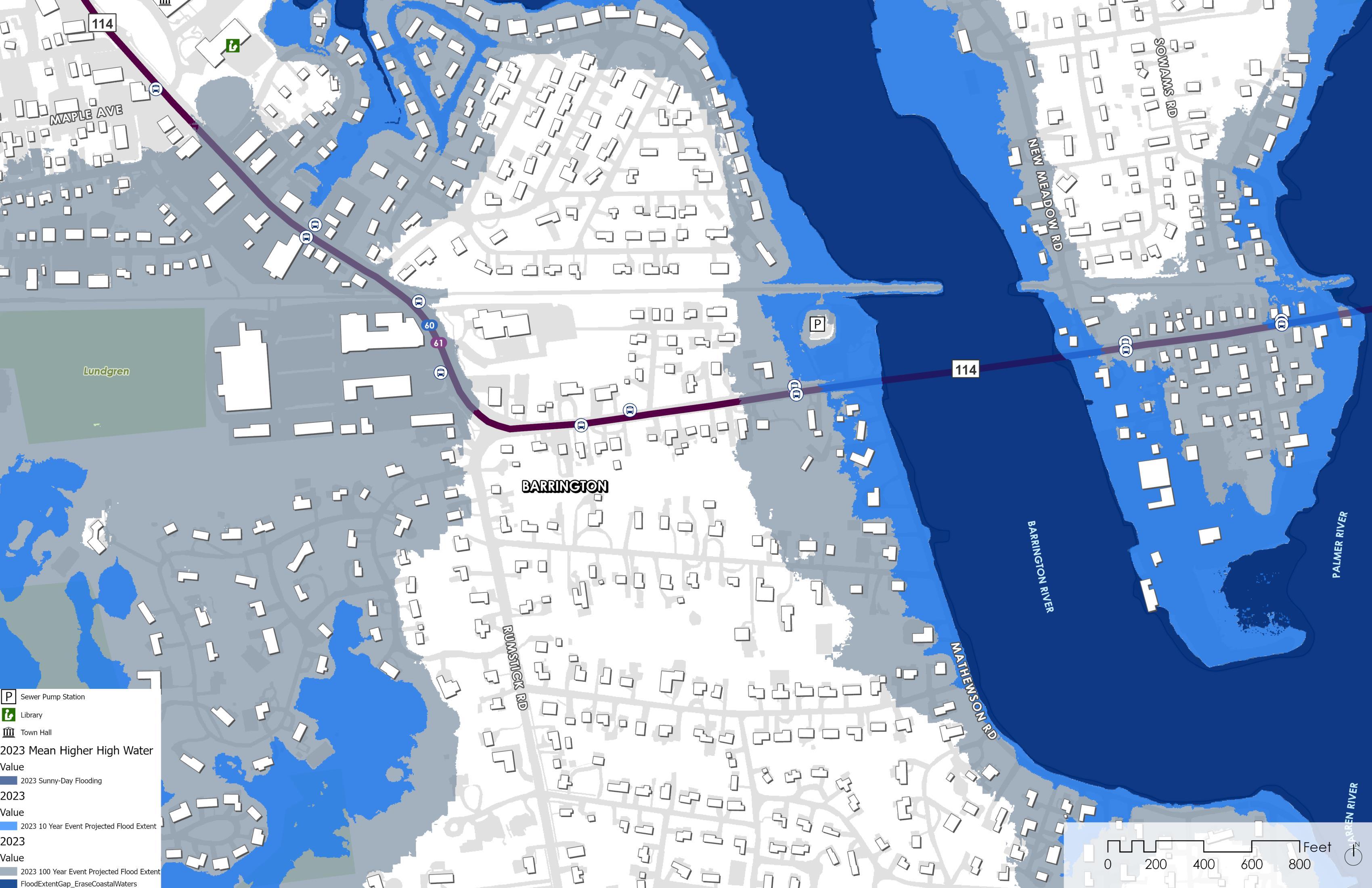
Sources: RIGIS, CRMC, Town of Barrington
the roadway. Furthermore, the extent of flooding may impact portions of Route 114 that convey traffic across the Barrington and Warren Bridges, which would impact residents commuting between Warren and Barrington. Additional Town-owned services will be impacted by the 10% annual chance event, including the Police Cove area and associated sewer pump station. While the pump station is elevated on higher ground, accessing the structure during a flooding event for repair or maintenance will be difficult.
During the 1% annual chance flood event, potential flooding impacts extend upland and impact more residential properties in the Jennys Lane and Riverside Drive neighborhoods. Four RIPTA bus stops are vulnerable to flooding under this flood scenario.
By the 2050s, sea level rise will increase the number of residential homes at risk from the 1% annual chance flood event, as well increasing the vulnerability of RIPTA bus stops from a 10% annual chance flood event.
The anticipated impacts of sea level rise on flooding event scenarios will expand flooding vulnerability to residential buildings in AOV4.
By the 2050s, the impacts of nuisance flooding will cause tidal waters to extend further into the Police Cove area and onto private residential property.
A 10% annual chance flooding event in the 2050s is projected to impact properties on Riverside Drive and

inundate greater portions of Route 114 westward of the Barrington Bridge.
A 1% chance flooding event in the 2050s will isolate a greater proportion of residential areas. Flooding extents will impact more residential homes in the Jennys Lane and Chapin Road neighborhoods, more portions of Riverside Drive, and extend along Route 114 westward towards the Shopping Center. The Barrington Bridge, Warren Bridge, and Police Cove pump station will be inaccessible during the 10% or a 1% annual chance flooding event.
Tidal Flooding (MHHW) + 2 Feet of SLR
10% Annual Chance Flood + 2 Feet of SLR
1% Annual Chance Flood + 2 Feet of SLR
Sources: RIGIS, CRMC, Town of Barrington
In AOV 4, the 5-10 feet of coastal flooding projected due to sea level rise would cut off access to critical services, including a pump station and Town bridges.
Future resilience planning in AOV 4, based on the 1% annual chance flood event + 2 feet of SLR, will need to focus on three key services: the Barrington Bridge, the Warren Bridge, and the Police Cove sanitary sewage pump station. The projected water depths under this scenario will make these services inaccessible due to coastal flooding.
The Barrington and Warren Bridges, which connect the Towns of Barrington and Warren, will be inaccessible with more than 10 feet of water at the base of both bridges in the future. This will

Sources: RIGIS, CRMC, Town of Barrington
have major impacts on Town safety and evacuation routes. Additionally, the Police Cove sanitary sewage pump station will not be accessible in the event of failure during a flooding event, as Route 114 will be inundated with over 7 feet of water at the entry point.
Along Mathewson Road, residential homes may have water depths as deep as 5-10 feet. This will prevent safe egress from the properties and may result in damages to personal property.

RI DEM and NWI have mapped one freshwater wetland south of Route 114 in AOV 4. The area of Route 114 to the east of the Barrington River is also mapped as a natural heritage area. Future flood projections indicate that the freshwater wetland will likely be inundated with 3 to 10 feet of coastal flooding during the 1% annual chance flood with 2 feet of SLR. The freshwater wetland is surrounded by residential properties, which will further limit its ecosystem function, adaptive capacity, and flood risk reduction capacity by limiting the potential for wetland migration.
LEGEND
1% Annual Chance Flood + 2 feet of SLR
Freshwater Wetland
Estuarine/Marine Wetland
Natural Heritage Areas
Sources: RIGIS, RIDEM, CRMC

In AOV 4, 183 buildings are likely to be impacted by the 1% chance flood with 2 feet of SLR, as coastal inundation will extend throughout the Police Cove area (Figure 14). The majority of these buildings are residential, with some commercial buildings and one municipal structure (Police Cove sanitary sewage pump station) in the area (see Figure 15). The number of residential buildings vulnerable to flooding impacts raises concern, as the closest evacuation route during an emergency would be the Barrington and Warren Bridges. However, these bridges will be impassable at a flood water depth of 1 foot or greater on Route 114. The alternative evacuation routes will still require residents to traverse inundated portions of Route 114 in other AOVs.


RIGIS, CRMC

With projected flood depths of 7.5 feet and 9.5 feet on either side of the Barrington Bridge during the future 10% annual chance flood event + 2 feet of SLR, one of the greatest challenges for AOV 4 will be egress through the southern portion of Town and reducing the vulnerability of residential properties along the Barrington River.
One of the few opportunities available to the Town in this AOV would involve improved communication with the public prior to a flooding event. For example, the Town could install signage along Route 114 that directs evacuees to the nearest alternative emergency route (e.g., Route 295) to avoid confusion during an evacuation. This opportunity could be a collaborative effort with the Town of Warren to ensure consistent messaging.
Additionally, the Town could consider raising portions of Route 114 in this AOV, including the Barrington Bridge. Raising Route 114 in this area would reduce floodwaters on the roadway and enable safe passage from the peninsula to the rest of Barrington. However, depending on the extent of road raising, this alternative presents several additional challenges. First, this solution would not completely address the projected future coastal flooding events likely to be faced by many of the residences along Mathewson Road, Riverside Drive, Tyler Point Road, and Barton Avenue. Additionally, raising the road in this area would require the regrading of many intersections, adjoining streets, and driveways to meet new grades established by the elevated roadway.
AOV 5 is bound in the north by the WarrenBarrington Bridge that transverses Palmer River, and in the south by the intersection of Route 114 and Hope Street. The Tourister Mill, which is a large apartment complex, is located near the northern boundary of the AOV. Some critical facilities located in this AOV include a school, the Warren Fire Department Rescue Station, Bierman Autism Center, and The Corliss Institute.
The RIPTA 60 and 61 bus routes run along the portion of Route 114 daily with multiple stops in this AOV.
Route 114 in Warren was ranked number one in the top 10 road assets in the Town of Warren vulnerable to SLR in the Warren, RI Coastal Sea Level Rise and Storm Surge: Transportation Fact Sheet (RISPP, 2016).
Downtown Warren is a Historic District and includes several properties along Main Street that were recommended for National Register of Historic Places status to the RI Historical Preservation & Heritage Commission. Water and sewer lines currently run under portions of Route 114 and are vulnerable to flooding.

2.
Under present-day conditions, tidal flooding is less of an issue in this section of Route 114 when compared to the effects of modeled storm surge.
Historically, during heavy storms and rain events, flooding has occurred in this area, especially when paired with high winds. These storms can make Route 114 impassable due to flooding. In discussions with members of the community, the areas of Route 114 that have historically experienced flooding align with the flooding modeled in STORMTOOLS and shown in this map.
According to the modeling from STORMTOOLS, during the 10% annual chance flood, two RIPTA bus stops are affected by coastal flooding, along with several buildings (including the Autism Center).
Tidal Flooding (MHHW) in 2023
10% Annual Chance Flood in 2023
1% Annual Chance Flood in 2023

Sources: RIGIS, CRMC, Town of Warren
Route 114 is flooded from the WarrenBarrington Bridge to the intersection of 114 and Thompson Street.
During the 1% annual chance flood, a total of 6 RIPTA bus stops are likely to be impacted by coastal flooding, and Route 114 would be flooded from the Warren-Barrington Bridge to the intersection of 114 and Union Street. There is a high point on Route 114 just north of St. Alexander Catholic Church at the cemetery, at approximately elevation 14 feet (NAVD 88), but the road continues to be exposed to coastal flooding during the modeled 1% annual chance flood further south between St. Alexander Catholic Church and Park Street. The Autism Center, along with The Corliss Institute, would also likely experience flooding under these conditions.
Under projected sea level rise conditions, the extent of flooding along Route 114 in AOV 5 reaches farther south, increasing the length of road that would experience flooding.
Projected modeling shows that under future conditions, MHHW will cause nuisance flooding of Route 114 near the Warren-Barrington Bridge.
The extent of flooding for the 10% and 1% annual chance flood increase under projected future conditions. Under the 10% annual chance flood, flooding is projected to occur from the Warren-Barrington Bridge to the intersection of 114 and Kelly Street.

During the future 1% annual chance flood, flooding is projected to occur from the Warren-Barrington Bridge and reach Norbert Street. The Corliss Institute sits on the corner of Route 114 and Norbert Street and is projected to be affected by flooding during these flood conditions.
Under these conditions, the entirety of Route 114 would experience flooding, including the high point at the St. Alexander Catholic Church Cemetery. Under present-day conditions, this portion of Route 114 does not experience flooding impacts.
Tidal Flooding (MHHW) + 2 Feet of SLR
10% Annual Chance Flood + 2 Feet of SLR
1% Annual Chance Flood + 2 Feet of SLR
Sources: RIGIS, CRMC, Town of Warren

Route 114 is projected to experience the deepest flood depth (around 14 feet) in the future in the area south of the Warren-Barrington Bridge near the Tourister Mill.
In the future, the deepest areas of flooding (14 feet) are projected to occur near the northern boundary of AOV 5 at the Warren-Barrington Bridge. The bike path that runs parallel to Route 114 would also become unusable in these conditions. As Route 114 runs south, the amount of flooding is projected to decrease until it reaches a high point in the road between Union Street and Warren Avenue where flooding would decrease to a few feet. Flooding impacts are then expected to worsen as the road continues south and flooding depth increases to 7 feet.
Flooding then decreases to only a few inches near The Corliss Institute, as the road elevation continues to increase to the south.
Under these conditions, a total of 5 bus stops would experience significant flooding, with the northernmost bus stop in this AOV experiencing the worst flooding impacts, with over 10 feet of flooding. The Autism Center is also expected to experience major flooding under these conditions at around 14 feet of flooding, and The Corliss Institute would experience a range of flood depths up to 3 feet.
Sources: RIGIS, CRMC, Town of Warren

Estuarine emergent wetlands are mapped to the north of Route 114 in AOV 5 by RI DEM and NWI. The majority of Route 114 in this area also transects an urbanized, mapped natural heritage area. Projected coastal flood conditions indicate the wetlands in AOV 5 will likely be inundated with greater than 10 feet of coastal flooding during a 1% annual chance flood with 2 feet of SLR, which will have significant impacts on the ecosystem function of the wetlands. In addition, the built environment along Route 114 (including the East Bay Bike Path) will act as a barrier for marsh migration and adaptation. The projected rate of tidal flooding and the existing built environment will prohibit the ability of natural resources to adapt.
LEGEND
1% Annual Chance Flood + 2 feet of SLR
Freshwater Wetland
Estuarine/Marine Wetland
Natural Heritage Areas
Sources: RIGIS, RIDEM, CRMC

A total of 221 buildings are likely to be impacted during the future 1% annual chance flood with 2 feet of SLR. These buildings include a wide variety of uses; however, most of the impacted buildings are residential. The large number of vulnerable residential buildings raises concern, as several residential properties, including the Tourister Mill Apartments (see Figure 16), lack an evacuation route that is not impacted by the future 1% annual chance flood. For several of these houses, there is only one major evacuation route, which is Route 114.
For some buildings in the area that are at risk of inundation by up to 14 feet of water during a future 1% annual chance flood, the cost of impacts from flooding could be irreparable. This type of flooding also poses a safety risk if residents are not able to evacuate to safety in time to avoid becoming trapped in their homes. As flooding depths decrease, like at St. Alexander Catholic Church, damages tend to be less costly and potentially easier to avoid through the implementation of adaptive measures.

1% Annual Chance Flood + 2 feet of SLR
Commercial (14 buildings)
Commercial/Residential Mixed (4 buildings)
Residential (189 buildings)
Manufacturing/Light Industrial (11 buildings)
Municipal/Institutional (3 buildings)


The northern part of Route 114 in this AOV is projected to be under 14 feet of water during the 1% annual chance flood event with 2 feet of SLR. Due to the proximity of buildings on Route 114, road raising may not be a viable option. This is due to the necessary widening of the road footprint often required to elevate roadways. The Warren-Barrington Bridge would also need to be raised to accommodate the raised road. This would alter the overall aesthetics of the bridge, potentially impacting the look and feel of the area.
Flooding in this AOV is projected to occur from all directions except from the south. This creates a challenge because evacuation routes during flooding events are limited to Route 114 heading south. Modeling shows that the alternate north-south route of Water Street may also be impacted during the present-day 1% annual chance flood event.
One opportunity for improving the resilience of the Route 114 corridor in AOV 5 is to make Route 114 resilient to projected future nuisance flooding and focus on implementing an efficient early warning system for evacuation before flooding occurs. Notifying residents that they reside in a floodplain would be key to this early warning system so that residents can be ready to evacuate if needed.
During tidal flooding events, a small section of the bridge approach in the northern portion of the AOV could be raised to keep it out of the projected future MHHW flooding. Engineered or hybrid infrastructure solutions (e.g., elevated walls) could potentially be used in this area to prevent water from coming onto the road.
Additionally, as suggested by some community stakeholders, emergency ferries could be considered in the future to aid in evacuations and emergency responses. Daily ferries to replace RIPTA bus routes could also be utilized to mitigate the impact flooding may have on local bus routes.
AOV 6 is bound by the intersection between Route 114 and Chestnut Street in the north and Franklin Street in the south. This area is a vital artery to downtown Bristol from the north that contains many restaurants and small businesses. This section of Route 114 is designated as a State Scenic Roadway.
Guiteras Elementary School, the Silver Creek Rehab and Healthcare Center, and Bristol VFW Post 237 are all critical facilities that are located in this AOV. Other critical services, such as the Bristol Senior Center and Benjamin Church Manor, are also within this AOV but not at risk of flooding from current or future flooding events.
AOV 6 also contains the Silver Creek Bridge, which is a particularly vulnerable area due to the occasional flooding of the Silver Creek that runs underneath the bridge and discharges to Bristol Harbor. According to a study titled ‘Vulnerability of Transportation Assets to Sea Level Rise’ (RIDSP, 2015), the Silver Creek Bridge was rated one of the most vulnerable bridges under state jurisdiction. This portion of the road is also on Bristol’s Fourth of July Parade route – an important cultural, historical, and economic development event.

Coastal flooding across the Silver Creek Bridge is a present-day issue during heavy rainstorms combined with high tides.
The Silver Creek Bridge, which is the section of Route 114 that spans across Silver Creek, experiences frequent flooding during major storm events. This causes the road to become dangerous to pass.
Tidal flooding does not affect Route 114 under present-day conditions; however, under present-day conditions, it is projected that a 10% annual chance flood event would flood a large section of Route 114 spanning from the Beach House Restaurant to Oliver Street. This flooding would affect three RIPTA bus
Tidal Flooding (MHHW) in 2023
10% Annual Chance Flood in 2023
1% Annual Chance Flood in 2023

Sources: RIGIS, CRMC, Town of Bristol
stops and limit access to the Guiteras Elementary School from the north and the Silver Creek Healthcare Center from the south.
Under a 1% annual chance flood, Route 114 would experience flooding from north of Poppasquash Road to Oliver Street. The number of bus stops affected by flooding would increase to seven, and Route 114 would become impassable, forcing traffic to be rerouted to Sherry Ave, which is a narrow roadway that may not be able to handle the additional traffic flow. This would also cause 12 bus stops to be taken out of service due to the detour. Guiteras Elementary School and the Silver Creek Healthcare Center would also be inaccessible due to the flooding under these projected conditions.
Under future, projected conditions, Route 114 is at risk of more frequent nuisance and is likely to experience larger areas of coastal flooding during the 10% and 1% annual chance flood.
Silver Creek Bridge is projected to experience flooding under future conditions during tidal flooding events. This would affect the ability of northsouth travel through Bristol on a frequent basis, and traffic would be forced to reroute to Sherry Ave.
During the future 10% annual chance flood, Route 114 could see flooding span from south of Creek Lane to south of Oliver Street. This would impact the Silver Creek Rehab and Healthcare Center, and it would cause Guiteras Elementary to become isolated due to flooding. Five RIPTA stops would also be impacted by flooding.
Tidal Flooding (MHHW) + 2 Feet of SLR
During the future 1% annual chance flood, flooding along Route 114 could reach as far north as the area between Hillside Road and Poppasquash Road and as far south as Oliver Street. Seven RIPTA stops would be impacted by flooding, and the Guiteras Elementary School and the Silver Creek Rehab and Healthcare Center would become inaccessible.
For both the 10% and 1% annual chance flood, Route 114 would not be able to convey north-south traffic, and all traffic would have to be routed to Sherry Ave.
10% Annual Chance Flood + 2 Feet of SLR
1% Annual Chance Flood + 2 Feet of SLR

Sources: RIGIS, CRMC, Town of Bristol
SILVER CREEK REHAB AND HEALTHCARE CENTER
GUITERAS ELEMENTARY SCHOOL
Route 114 could be under as much as 12.5 feet of flooding at its peak during the future projected 1% annual chance flood.
At its deepest, flooding could be up to 12.5 feet north of the Silver Creek Bridge during the future 1% annual chance flood. The Silver Creek Bridge is a low point in this AOV, and as Route 114 stretches north and south, flooding decreases as the road increases in elevation.
North of the Silver Creek Bridge, flood depths range from under 4.5 feet to greater than 10 feet of water prior to a rise in the roadway elevation between Creek Lane and Hillside Road where there are only a few inches of projected flooding.

Sources: RIGIS, CRMC, Town of Bristol
South of Silver Creek Bridge, the elevation of Route 114 is relatively flat compared to the north, with elevation increasing quickly beyond Oliver Street.
Also of concern in this area, the Silver Creek Healthcare Center and Guiteras Elementary School could be under 4.5 to 10 feet of flooding during the future 1% annual chance flood, which could potentially cause significant damage to these buildings. Major damage could also be caused to the utilities that run through Silver Creek Bridge under these future flood conditions.

Mapped estuarine emergent wetlands are in close proximity to Route 114 within AOV 6. The entirety of Route 114 in this area occurs within mapped natural heritage areas. Future flood projections indicate natural resources will be inundated by coastal flood waters with greater than 10 feet of water during the 1% annual chance flood with 2 feet of SLR, reducing the ecological function of the wetlands in this area. However, the restriction of flow from the Silver Creek Bridge will help slow the inundation of natural resources; therefore, there is potential for the wetlands to adapt and migrate into adjacent upland habitats if unimpeded by urban development in the area.
LEGEND
1% Annual Chance Flood + 2 feet of SLR
Freshwater Wetland
Estuarine/Marine Wetland
Natural Heritage Areas
Sources: RIGIS, RIDEM, CRMC

A total of 220 structures are likely to be impacted during the future 1% annual chance flood, most of which are residential. However, the Guiteras Elementary School (see Figure 17), Silver Creek Rehab and Healthcare Center, and Bristol VFW Post 237 are also likely to be impacted by these projected flood conditions.
The structures that are closest to Silver Creek, which will most likely experience the greatest amount of flooding in the future, would also be at risk of more extensive flood-related damages. These damages could be substantial, especially if the future flooding reaches more than 3 feet above the first-floor elevation. This is the elevation at which many of the easier flood mitigation options (e.g., dry floodproofing) become infeasible due to the cost of implementation and/or safety concerns of being able to evacuate from buildings/properties with high barriers.

17: Image of the Guiteras Elementary School LEGEND
1% Annual Chance Flood + 2 feet of SLR
Commercial (9 buildings)
Commercial/Residential Mixed (0 buildings)
Residential (197 buildings)
Manufacturing/Light Industrial (6 buildings)
Municipal/Institutional (8 buildings)
Sources: RIGIS, CRMC

There is currently a lack of north-south connectors through Bristol, with the main connectors being Route 114 and Metacom Avenue. As future projected depths during coastal flooding events increase in the area, Route 114 will no longer be able to serve as one of the primary north-south connectors, and mitigation measures (e.g., road raising) become less feasible. Additionally, the gas and sewer utilities that run under Route 114 pose a challenge in the future, as they will likely need to be relocated or protected to reduce their risk from the impacts of more severe coastal flooding events. Inland flooding is another challenge that this section of Route 114 faces via Silver Creek. Because Route 114 experiences flooding from both the coastal and inland sides, any coastal flooding mitigation actions must also consider inland flooding mitigation actions.
One opportunity for addressing future flood risks could be to raise the lower elevation portions of Route 114 in this area to meet the higher elevations to the north and south of the Silver Creek Bridge area (see Figure 18) to reduce the risk of impacts from future nuisance flooding. This could also reduce upstream flood risk because the raised road could serve as a berm. This would allow Route 114 to become more usable as a north-south connector road in the future during non-storm events. Route 114 could also be redesigned to better withstand overtopping to allow for a quicker return to service when flood waters recede following a storm event. Additionally, the Town could also consider constructing a berm between Route 114 and Bristol Harbor for added flood risk reduction. The berm could also then create an opportunity for improved public access to the waterfront.
Widening of Sherry Avenue in the future may make it more viable as an alternate route during coastal storm events. This could help support a retreat route where High Street slowly starts to become the new Main Street, and the existing Route 114 corridor in this AOV become a walkable waterfront space. Extending Wood Street to connect north to Chestnut Street provides another alternative north-south route.

AOV 7 is bound in the north by Constitution Street and the south by Griswold Avenue. A particularly vulnerable area of Route 114 in this AOV is the section of road above Tanyard Brook and the Burton Street Bridge. This section of the road is prone to flooding. This section of Route 114 is also designated as a State Scenic Roadway and contains the Bristol Water Pollution Control and Bristol Sewer Plant.
This AOV provides access to Bristol’s downtown area from the south and is also on Bristol’s Fourth of July Parade path.

Under current conditions, the 1% and 10% annual chance flood events are more of a concern compared to more frequent tidal flooding.
Under current conditions, tidal flooding is not a primary concern, as it does not affect Route 114 in this area.
However, for the 10% annual chance flood, the section of Route 114 between the Lobster Pot Restaurant and the intersection with Wood Street is expected to experience significant amounts of flooding. Three RIPTA bus stops in this area would be prone to flooding under these conditions, and traffic would need to be rerouted through nearby Wood Street and Walley Street.
During the 1% annual chance flood, a larger portion of Route 114 would experience flooding, ranging from Union Street in the north to just south of

Tidal Flooding (MHHW) in 2023
10% Annual Chance Flood in 2023
1% Annual Chance Flood in 2023
Sources: RIGIS, CRMC, Town of Bristol
Fairview Drive in the south. Eight RIPTA bus stops would likely be impacted by flooding under these conditions, and a major reroute would be needed to avoid flooding in this area, as vehicles would need to use Griswold Ave to get to Metacom Ave. Additionally, access to the Bristol Water Pollution Control and Bristol Sewer Plant would be affected during the 1% annual chance flood.
The Burton Street Bridge is also a key area of concern in this AOV, as the road in this area is supported by a retaining wall that is in poor condition. This poor condition allows for undermining of the road that could be worsened by coastal flooding and would further threaten the structural integrity of the road.
Compared to present conditions, the extent of flooding in AOV 7 only increases under future, projected conditions.
Under future, projected conditions, tidal flooding still does not affect Route 114 in this AOV. However, the extent of the 10% annual chance flood spans to the north of the Lobster Pot Restaurant and closer to the intersection of Wood Street. Two RIPTA stops would still be affected under these future conditions, and the same detour as was mentioned in the previous page (under current conditions) would be needed during the 10% annual chance flood event.

Similarly, during the future 1% annual chance flood, the mapped flood extents also increase. In the north, the flooding is projected to reach between Pleasant Street and Constitution Street. In the south, flooding is projected to extend between Fairview Drive and Griswold Avenue. The same number of RIPTA stops would be affected by the future 1% as the present 1% annual chance flood events, and the Bristol Water Pollution Control and access to the Bristol Sewer Plant would still be affected.
Tidal Flooding (MHHW) + 2 Feet of SLR
10% Annual Chance Flood + 2 Feet of SLR
1% Annual Chance Flood + 2 Feet of SLR
Sources: RIGIS, CRMC, Town of Bristol

A large section of Route 114 is projected to be flooded by over 10 feet of water during the future projected 1% annual chance flood.
The highest flood depth along this section of Route 114 is projected to be around 13 feet. This depth decreases to 11 feet as the road travels north; however, as Route 114 continues along the coastline to the north, the flood depths remain significant in this portion of the low-lying road until it reaches higher elevations between Pleasant Street and Constitution Street.
Under the future 1% annual chance flood scenario, projected flood depths on Route 114 would limit access to the Bristol Water Pollution Control Plant and Bristol Sewer Plant. Flood depths could reach up to 7.5 feet, which would cut
off the only access road. This makes this area more vulnerable and raises the need to examine alternatives that would maintain access to these important community facilities. The Water Pollution Control plant presents a future opportunity for additional floodproofing measures, where needed.
Importantly, eight of the RIPTA bus stops in this AOV would become inaccessible under future 1% annual chance flood events, as the depth of flood water would make the road impassible by bus.
Sources: RIGIS, CRMC, Town of Bristol

There are no mapped wetlands in close proximity to Route 114 within AOV 7. NWI identified a small estuarine wetland, and RI DEM identified an unconsolidated shoreline and rocky shore habitat south of Route 114 (see Figure 19). These mapped natural resources are separated from the Route 114 corridor by the built environment and have limited risk reduction and adaptation capabilities. The majority of Route 114 within AOV 7 occurs within a mapped natural heritage area.


A total of 111 structures would be impacted during the future, projected 1% annual chance flood event. Most of the structures impacted by flooding under these conditions would be residential, though there are also several restaurants, small businesses, museums, and key access roads in the flood extents. Damage to critical infrastructure, such as the Bristol Water Pollution Control facility (see Figure 20), could be significant if mitigation measures are not in place to protect this structure from coastal flood inundation.

LEGEND
1% Annual Chance Flood + 2 feet of SLR
Commercial (3 buildings)
Commercial/Residential Mixed (0 buildings)
Residential (106 buildings)
Manufacturing/Light Industrial (1 building)
Municipal/Institutional (1 building)
Sources: RIGIS, CRMC

The length and location of Route 114 along the coastline in this area (see Figure 21) present a major challenge to coastal flood resilience, as most of the road has an elevation below 15 feet. Additionally, there is limited space between the road and Bristol Harbor to implement flood risk mitigation alternatives (e.g., road raising or elevated walls) that may require larger road footprints. Access to the Bristol Water Pollution Control Facility during a storm is also a challenge, as this is a critical Town facility.
Because of the low risk of tidal flooding, there is an opportunity to focus flood mitigation measures in this area on evacuations during storm events. For example, Wood Street – which sits at a higher elevation than nearby Route 114 –could be used in the future to effectively reroute traffic from a portion of Route 114 during coastal storm events. Route 114 could also be made resilient to overtopping and saltwater exposure and increase the ability of the road to be useable after flooding has subsided.
Adding signage of where flooding is predicted to occur in the future may also help inform the public of the flood risk in this area. Similar to AOV 6, there is also the opportunity in this area to make Wood Street the permanent north-south route in the future and convert Route 114 into a walkable coastal area.

CRMC. (2016). Sea Level Affecting Marshes Model (SLAMM). In Rhode Island Geographic Information System (RIGIS).
CRMC. (2018). Rhode Island Shoreline Change Special Area Management Plan. Rhode Island Coastal Resources Management Council.
CRMC, & URI. (2023). STORMTOOLS. In Rhode Island Geographic Information Systems (RIGIS). RI Coastal Resources Management Council and the University of Rhode Island.
Jacobs, K. (2022). Town of Barrington Rhode Island Hazard Mitigation & Flood Management Plan - Revised 2022.
NOAA. (2023). Sea Level Rise View. https://coast.noaa.gov/slr/
Rhode Island Division of Planning. (2015). Vulnerability of Transportation Assets to Sea Level Rise.
Rhode Island State Planning Program. (2016). Warren, RI Costal Sea Level Rise and Storm Surge: Transportation Fact Sheet.
Spaulding, M., Grill, A., Damon, C., Hashemi, R., Anbaran, S. K., & Fugate, G. (2019). STORMTOOLS Design Elevation (SDE) Maps: including impact of sea level rise. In RI CRMC Beach SAMP . Coastal Resources Center.
State of Rhode Island. (2018). Resilient Rhody: An Actionable Vision for Addressing the Impacts of Climate Change in Rhode Island.
Town of Barrington. (2015). Town of Barrington Comprehensive Community Plan - 2015 Update.
URI. (2013). Sea Level Rise in Rhode Island: Trends and Impacts. University of Rhode Island.

4. APPENDICES
Appendix A: Data Collection + Plan Review References
Appendix B: Plan Review Technical Memorandums
Appendix C: Additional AOV Zoning Maps
Sea Level Rise and Vulnerable Infrastructure References:
CRMC, 2020. STORMTOOLS Inundation Series; MHHW Surface with 0-Feet and 2Feet of Sea Level Rise, NACCS Derived Inundation Surfaces Incorporating Storm Surge and Tide for a 10-Year Event With 0-Feet and 2-Feet of Sea Level Rise, NACCS Derived Inundation Surfaces Incorporating Storm Surge and Tide for a 100-Year Event With 0-Feet and 2-Feet of Sea Level Rise. URL: http://www.rigis.org, Environmental Data Center, University of Rhode Island, Kingston, Rhode Island (last date accessed: 6 December 2023).
RIGIS, 2016. Rhode Island Department of Transportation Roads; RIDOTrds16. Rhode Island Geographic Information System (RIGIS) Data Distribution System, URL: http://www.rigis.org, Environmental Data Center, University of Rhode Island, Kingston, Rhode Island (last date accessed: 6 December 2023).
RIGIS, 2016. RIPTA Bus Routes and stops; RIPTAroutes0916, RIPTAstops0916. Rhode Island Geographic Information System (RIGIS) Data Distribution System, URL: http://www.rigis.org, Environmental Data Center, University of Rhode Island, Kingston, Rhode Island (last date accessed: 6 December 2023).
RIGIS, 2017. Fire Stations; fireStns14c. Rhode Island Geographic Information System (RIGIS) Data Distribution System, URL: http://www.rigis.org, Environmental Data Center, University of Rhode Island, Kingston, Rhode Island (last date accessed: 6 December 2023).
RIGIS, 2018. Building Footprints; buildingFootprints18. Rhode Island Geographic Information System (RIGIS) Data Distribution System, URL: http://www.rigis.org, Environmental Data Center, University of Rhode Island, Kingston, Rhode Island (last date accessed: 6 December 2023).
RIGIS, 2022. Land Use and Land Cover (2022). Rhode Island Geographic Information System (RIGIS) Data Distribution System, URL: https://www.rigis.org, Environmental Data Center, University of Rhode Island, Kingston, Rhode Island (last date accessed: 6 December 2023).
RIGIS, 2023. Pre-K to 12 Schools; Rhode Island Geographic Information System (RIGIS) Data Distribution System, URL: https://www.rigis.org, Environmental Data Center, University of Rhode Island, Kingston, Rhode Island (last date accessed: 6 December 2023).
Towns of Barrington, Bristol, and Warren, Various. Utility GIS data.

Natural Resource References:
RIGIS, 2000.Eelgrass beds in Rhode Island (Polygon); s44nep99. Rhode Island Geographic Information System (RIGIS) Data Distribution System, URL: http://www.rigis.org, Environmental Data Center, University of Rhode Island, Kingston, Rhode Island (last date accessed: 6 December 2023).
RIGIS, 1993. Wetlands; s44wwt93. Rhode Island Geographic Information System (RIGIS) Data Distribution System, URL: http://www.rigis.org, Environmental Data Center, University of Rhode Island, Kingston, Rhode Island (last date accessed: 6 December 2023).
RIGIS, 2022. Rhode Island Natural Heritage Areas. Rhode Island Geographic Information System (RIGIS) Data Distribution System, URL: https://www.rigis.org, Environmental Data Center, University of Rhode Island, Kingston, Rhode Island (last date accessed: 6 December 2023).
Town of Barrington
Jacobs, K. (2022). Town of Barrington Rhode Island Hazard Mitigation & Flood Management Plan - Revised 2022.
Nelson Nygaard. (2016). Town of Barrington, Rhode Island 2016 Village Center Parking Study.
Rhode Island State Planning Program. (2016a). Barrington, RI Coastal Sea Level Rise and Storm Surge: Transportation Fact Sheet.
Town of Barrington. (2015a). Town of Barrington Comprehensive Community Plan2015 Update.
Town of Barrington. (2015b). Town of Barrington Comprehensive Community Plan2015 Update Maps.
Town of Barrington. (2019). Barrington Community Resilience Building Workshop Summary of Findings Report 2019.
Town of Bristol
Bristol Hazard Mitigation Committee. (2010). Natural Hazard Mitigation Plan of the Town of Bristol, Rhode Island- Revised 2010.
Natural Hazard Mitigation Plan of the Town of Bristol, R. I.-R. 2010. (2009). Natural Hazard Mitigation Plan of the Town of Bristol, Rhode Island.
Rhode Island State Planning Program. (2016b). Bristol, RI Costal Sea Level Rise and Storm Surge: Transportation Fact Sheet.
Town of Bristol. (2017). Town of Bristol 2016 Comprehensive Community Plan.
Town of Bristol. (2020). Municipal Resilience Program Community Resilience Building Workshop Summary of Findings.
Town of Warren
Jacobs, K. (2022). Town of Warren Rhode Island Hazard Mitigation & Flood Management Plan.
McMahon Company. (2022). Downtown Warren Parking Study Summary of Parking Utilization Data Collection.
Rhode Island State Planning Program. (2016c). Warren, RI Costal Sea Level Rise and Storm Surge: Transportation Fact Sheet.
Town of Warren. (2019). Town of Warren Municipal Resilience Program: Community Resilience Building Workshop Summary of Findings .
Town of Warren. (2022). Town of Warren Rhode Island Comprehensive Plan, 2022.
State of Rhode Island & Other References
CRMC. (2016). Sea Level Affecting Marshes Model (SLAMM). In Rhode Island Geographic Information System (RIGIS).
CRMC. (2018). Rhode Island Shoreline Change Special Area Management Plan. Rhode Island Coastal Resources Management Council.
Rhode Island Division of Planning. (2015a). Vulnerability of Municipal Transportation Assets to Sea.
Rhode Island Division of Planning. (2015b). Vulnerability of Transportation Assets to Sea Level Rise.
State of Rhode Island. (2018). Resilient Rhody: An Actionable Vision for Addressing the Impacts of Climate Change in Rhode Island.
The University of Rhode Island, & Coastal Institute. (2021). Preparing for Resilience, Barrington and Warren Mixed-Use Climate Response Demonstration SiteRevised 2021.
URI. (2013). Sea Level Rise in Rhode Island: Trends and Impacts. University of Rhode Island.

TO: Roberta Groch, AICP - Assistant Chief, RI Division of Statewide Planning Caitlin Greeley, Principal Planner, RI Division of Statewide Planning
CC: Teresa Crean, AICP, Director of Planning, Building and Resilience, Town of Barrington
FROM: Arnold Robinson, AICP, NCI, WEDG
Shawna Little, PhD
DATE: February 13, 2024
RE: Resilient Route 114 Project, Task 3
Review Town of Barrington Existing Documents
Fuss & O’Neill reviewed the Town of Barrington’s plans, studies, maps, and reports to identify elements of these planning documents that mention actions, policies, priorities, and strategies related to Route 114, especially those that focus on improving the overall resilience of the Route 114 corridor. The existing plans, studies, maps, and reports reviewed included:
• Town of Barrington Comprehensive Community Plan, 2015 Update (BCCP, 2015)
• Town of Barrington Comprehensive Community Plan Maps, 2015 Update (BCCP Maps, 2015)
• Town of Barrington Hazard Mitigation and Flood Management Plan, 2022 (BHMP, 2022)
• Town of Barrington Village Center Parking Study, 2016 (BVCPS, 2016)
• Town of Barrington Community Resilience Building Workshop Summary of Findings Report, 2019 (CRB, 2019)
• University of Rhode Island Preparing for Resilience, Barrington, and Warren Mixed-Use Climate Response Demonstration Site, Fall 2019 (URI, 2019)
• University of Rhode Island Preparing for Resilience, Barrington and Warren Mixed-Use Climate Response Demonstration Site, Accomplishments, December 2021 (URI, 2021)
• Rhode Island Statewide Planning Program Vulnerability of Municipal Transportation Assets to Sea Level Rise, January 2015 (RISPP, 2015)
• Rhode Island Statewide Planning Program Vulnerability of Municipal Transportation Assets to Sea Level Rise and Storm Surge: Transportation Fact Sheet, September 2016 (RISPP, 2016)
Currently, the Barrington Comprehensive Community Plan does not specifically address climate resiliency as it relates to natural, historic, or cultural resources along Route 114. However, the Town did include resilience improvements as a general theme in the BCCP Implementation Plan (page 149), and
F:\P2021\0956\A10\Prior studies related to 114 and transportation network\Draft EC Summary Report\Revised Drafts\Draft_Plan
Review_Memo Barrington 20231108_REV20240206.docx
MEMO – Roberta Groch, AICP
February 13, 2024
Page 2 of 10
the Town set goals to improve resilience via the preservation of the natural environment under Natural Hazards (Goal NH-2; BCCP, page 131).
Route 114 (Wampanoag Trail, County Road) was identified as a particular area of concern in the Town’s Community Resilience Building Workshop (CRB, 2019, page 4) due to potential impacts related to extreme weather events (e.g., hurricanes, Nor’Easters, etc.), sea level rise (SLR), and coastal inundation, which threatens numerous sections of Route 114 (BHMP, 2022). For example, regular high tide flooding occurs on Route 114 near the High School and Prince Pond, as well as sections of New Meadow Road and Sowams Road near the Barrington and Palmer Rivers (BHMP, 2022, page 4-76; BCCP, 2015, page 123). Recent flooding events on Route 114 have resulted in extensive flooding in vulnerable, low-lying areas. One such example occurred on August 1st, 2012 when heavy rains caused portions of Route 114 to flood with 1.5 feet of water, specifically the area along the Warren/Barrington Border (BHMP, 2022). Similarly, in July of 2015, a flooding event caused New Meadow Road at Route 114 to flood with 6 inches of water along the Warren/Barrington Border (BHMP, 2022).
Future flooding projections assessing flood vulnerability for Route 114 have identified specific assets and portions of roadway that would be inundated by sea level rise. Based on the RIDSP vulnerability assessment of State transportation assets, three of the ten most vulnerable segments of roadway under state jurisdiction at risk of inundation by sea level rise, are located in Barrington: 1) County Road, 2) Massasoit Ave, and 3) Wampanoag Trail (RISPP, 2015, page 12; BHMP, 2022, pages 4-93 to 4-94). All three of these roads are part of the Army Corps of Engineers Hurricane Evacuation Route and are principal arteries for the Town. Table 1 below provides the linear feet of roadway projected to be inundated under 3 different scenarios of SLR. The Wampanoag Trail and County Road are principal arteries and local emergency routes, with an overall vulnerability score of 7.3 and 8.8, respectively (RISPP, 2015, page 12). This is in line with an assessment by URI which ranked Wampanoag Trail, north of White Church and County Road bridges (Barrington bridge and Warren bridge, as some of the highest priority transportation areas of concern in the Town (URI, 2019, page 14).
Table 1. The top-rated road segments in Barrington, under state jurisdiction, most vulnerable to inundation due to sea level rise with state ranking and the total linear feet of roadway that would be flooded under three different SLR scenarios (1, 3, and 5-ft) Adapted from the Vulnerability of Transportation Assets to Sea Level Rise (RIDSP, 2015, page 12).
Additional assets vulnerable to sea level rise include two major bridges along Route 114, the Barrington Bridge and Warren Bridge. The Barrington Bridge (carrying Route 114) is ranked #1 in the list of top 10
F:\P2021\0956\A10\Prior studies related to 114 and transportation network\Draft EC Summary Report\Revised Drafts\Draft_Plan Review_Memo Barrington 20231108_REV20240206.docx
MEMO – Roberta Groch, AICP
February 13, 2024
Page 3 of 10
bridges under state jurisdiction most vulnerable to sea level rise (RISPP, 2015, page 21). The bridge was built in 2009 with an annual average daily traffic (AADT) load of 26,000 vehicles per day, and it has only 10 inches of freeboard relative to 7 feet of SLR predicted to impact Barrington (RISPP, 2016). The Warren Bridge (carrying Route 114), ranked #2 in the same list, was built in 1914 with an AADT load of 19,900 vehicles per day, and has 14 inches of freeboard relative to the projected 7 feet of SLR in Barrington (RISPP, 2016).
Based on the Vulnerability Analysis Summary of the BHMP, there is an elevational low point on Route 114 adjacent to the current Barrington Community Garden, which is located in a FEMA flood zone This low-lying area is at risk of flooding due to Category 1 hurricanes, winter storms, and earthquakes (BHMP, 2022, Appendix 4-2 and 4-3). Additionally, it will be inundated by 3 feet of SLR, with a flood depth of 12.2 feet during a 100-year storm event Anticipated impacts include public safety, disruption of services, infrastructure damage, and economic loss.
Floodwaters on the road surface (in feet) of the intersection of Primrose Hill Road and Wampanoag Trail (Route 114) were projected as follows by the URI-CI internship program (Table 2; URI, 2021, page 18):
Table 2. Depth of floodwater inundating the intersection of Primrose Hill Road and Wampanoag Trail under four different SLR scenarios and storm surge Reproduced from the Preparing For Resilience Barrington, Warren, and Bristol Mixed-Use Climate Response Demonstration Site, Accomplishments (URI, 2021).
Aside from vulnerabilities to the Route 114 roadway itself, existing planning documents identified numerous services and facilities throughout the Route 114 corridor that are vulnerable to flooding, sea level rise, coastal inundation, and extreme weather events.
The BCCP identified multiple critical transportation assets, such as the Barrington River Bridge, Warren River Bridge, Warren River Bike path, and Barrington River Bike Path Bridge, as being primarily threatened by flooding, located in the 100-year flood zone (AE), and vulnerable to Category 1 hurricane storm surge. Other critical facilities identified by the vulnerability analysis included (BHMP, 2022, pages 473 to 74):
F:\P2021\0956\A10\Prior studies related to 114 and transportation network\Draft EC Summary Report\Revised Drafts\Draft_Plan
Review_Memo Barrington 20231108_REV20240206.docx
MEMO – Roberta Groch, AICP
February 13, 2024
Page 4 of 10
• Schools: Barrington Christian Academy (private), Primrose Hill School (public), St. Andrews School (Private), and Barrington High School (Public)
• Day care/early learning: Tot’s Cooperative Nursery School (private)
• Government/emergency centers: Town Hall/School Administration and Barrington Public Library (public)
• Institutional/commercial: East Bay Health Center (Private) and Barrington Shopping Center (private)
• Natural resources: Osamequin Nature preserve (public) and Walker Farm (public)
The vulnerabilities for each critical facility were identified in the BHMP (2022; Appendix 4-3) and are listed below:
• Barrington Christian Academy – services a vulnerable population, is in a FEMA Flood Zone (X) and at risk to a Category 4 hurricane, winter storms, and earthquakes.
• Barrington High School (Public) – services a vulnerable population, is in a FEMA Flood Zone (AE) and at risk of a Category 2 hurricane and earthquakes. The school will be inundated by 7 feet of sea level rise with a flood depth of 4.6 feet during a 100-year storm event
• Primrose Hill School (public) – services a vulnerable population, is in a FEMA Flood Zone (X) and at risk of earthquakes.
• St. Andrews School (Private) – services a vulnerable population, is in a FEMA Flood Zone (X) and at risk to a Category 3 hurricane and earthquakes. The school will be inundated by 12 feet of sea level rise with a flood depth of 1.9 feet during a 100-year storm event
• Tot’s Cooperative Nursery School services a vulnerable population, is in a FEMA Flood Zone (AE) and at risk of a Category 1 hurricane and earthquakes.
o The building will be inundated by 3 feet of sea level rise with a flood depth of 10.6 feet during a 100-year storm event
• Town Hall/School Administration building is in a FEMA Flood Zone (X) and at risk of earthquakes.
• Barrington Public Library – is in a FEMA Flood Zone (X) and at risk of earthquakes.
• East Bay Health Center is in a FEMA Flood Zone (X) and at risk of a Category 3 hurricane and earthquakes.
• Barrington Shopping Center is in a FEMA Flood Zone (AE) and at risk of a Category 2 hurricane, winter storms, and earthquakes.
o The building will be inundated by 10 feet of sea level rise with a flood depth of 5.7 feet during a 100-year storm event
• Osamequin Nature preserve is in a FEMA Flood Zone (AE) and at risk of a Category 1 hurricane, drought, and brush fires.
o Primary effects of problems will include property damage, disruption of access, coastal erosion, wetland, and habitat damage, mosquito, and tick-borne diseases.
F:\P2021\0956\A10\Prior studies related to 114 and transportation network\Draft EC Summary Report\Revised Drafts\Draft_Plan Review_Memo Barrington 20231108_REV20240206.docx
MEMO – Roberta Groch, AICP
February 13, 2024
Page 5 of 10
Flood-related impacts to each of these facilities will impact public safety, property damage, disruption of services, and economic losses. The Barrington Public Library also serves as an emergency warming/cooling center for the public.
Other notable services include the Walker Farm off Route 114, the Park & Ride at White Church on Route 114, and several sanitary sewerage pump stations (BHMP, 2022, Appendix 4-3). The vulnerabilities for each critical facility were identified in the BHMP (2022; Appendix 4-3) and are listed below:
• Walker Farm is in a FEMA Flood Zone (AE) and at risk of a Category 1 hurricane, extreme heat, and earthquakes.
• The Park & Ride at White Church on Route 114 is in the AE FEMA Flood Zone and at risk of a Category 1 hurricane and winter storms.
o It will be inundated by 2 feet of sea level rise with a flood depth of 11.4 feet during a 100year storm event.
• Sanitary sewerage pump stations (public), including the Police Cove Pump Station along Route 114 is in the AE FEMA Flood Zone and at risk of a Category 2 hurricane.
o It will be inundated with a flood depth of 0.7 feet during a 100-year storm event
• Sanitary sewerage pump stations (public), including the Prince Pond Pump Station along Route 114 is in the X FEMA Flood Zone and at risk of a Category 3 hurricane.
o It will be inundated by 7 feet of a sea level rise with a flood depth of 5.7 feet during a 100year storm event
Primary impacts will include disruption of services/access, public health risks, infrastructure damage, property damage, economic loss, coastal erosion, wetland and habitat damage, and no shade structures.
Each of the existing planning documents reviewed here by Fuss & O’Neill identify the need for alternatives for adaptation to future flooding and identify challenges regarding Wampanoag Trail. This included road improvements such as re-angle for drainage, elevate, or building a causeway to keep the roadway as a main thoroughfare (URI, 2019, page 14). The following includes a list of recommended actions or strategies for Route 114, and related roadways or facilities, aimed at improving the resilience of the Route 114 corridor:
• Immediate corrective action should be taken on evacuation routes, including Route 114, by working with RIDOT to complete drainage improvements on roadways under their jurisdiction through the installation of innovative water technology in areas subject to severe flooding (BHMP, 2022, page 6-10).
• Coordinate with RIDOT/RIDSP on Route 114 Corridor Study to assess existing and future vulnerabilities and options to reduce risk, including rerouting and raising (BHMP, 2022, page 6-
F:\P2021\0956\A10\Prior studies related to 114 and transportation network\Draft EC Summary Report\Revised Drafts\Draft_Plan Review_Memo Barrington 20231108_REV20240206.docx
MEMO – Roberta Groch, AICP
February 13, 2024
Page 6 of 10
12). Similarly, coordinate with RIDOT to ensure timely and adequate repairs and upgrades for the existing Barrington River Bridge (CRB, 2019, page 10).
o RIDOT engagement on repairs and upgrades to the Barrington River Bridge was categorized as a higher priority action item in the Town’s CRB Summary of Findings Report (CRB, 2019).
• Complete a neighborhood scale flood, storm surge, and SLR impact assessment using the mapping and data generated from a previous SLR exposure assessment of buildings and roadways town-wide, developed in partnership with the URI Coastal Institute. The assessment will include the impact on publicly and privately owned buildings and sites, roads, stormwater drainage system, sewer system, and other utilities (BHMP, 2022, page 6-14)
o Scope will involve generating cost estimates for mitigation projects, establishing project priorities, and identifying the intersection of residential homes in current and projected future flood zones to proactively educate the community on potential future remediation strategies such as home elevation, voluntary buyouts, and/or relocation (BHMP, 2022, page 6-14)
o Other potential priority projects include areas adjacent to Route 114 including the vicinity of the High School on Lincoln Ave, the vicinity of the Public Safety Building on Federal Road, Massasoit Ave neighborhoods,
• Accommodate marsh migration at Walker Farm on the west side of Route 114 in the area adjacent to Barrington Community Garden’s parking lot and further north at Osamequin Nature Preserve (BHMP, 2022, page 6-16)
o Note: This was also identified as a prioritized actions & projects in the Comprehensive Plan to Restore Water Quality in the Hundred Acre Cove (2021) (BHMP, 2022, Appendix 6-1).
• Complete a comprehensive assessment of the existing and future vulnerabilities and options to reduce risk for Route 114 including rerouting and raising, amongst others (BHMP, 2022, Appendix 4-2 and 6-1; CRB, 2019, page 11).
o This was categorized as a high priority action item in the Town’s CRB Summary of Findings Report (CRB, 2019).
• Complete an assessment of the local alternative routes for residents to access during an emergency flooding event, specifically evacuation routes across and out of the municipality (CRB, 2019, page 13).
o This was categorized as a moderate priority action item in the Town’s CRB Summary of Findings Report (CRB, 2019).
• Under a modest 3-ft rise in sea level, portions of Route 114 will need to be reinforced (elevated), bridges along Route 114 and bridges and roads that provide access to Route 114 will need to be elevated. With 5-7 feet of sea level rise, the report suggests retreat from portions of Wampanoag Trail will be necessary and roadways realigned throughout Barrington and Warren to maintain routine transportation corridors and emergency routes. Abandoned roads will be restored to natural habitats (URI, 2019, page 18).
F:\P2021\0956\A10\Prior studies related to 114 and transportation network\Draft EC Summary Report\Revised Drafts\Draft_Plan Review_Memo Barrington 20231108_REV20240206.docx
MEMO – Roberta Groch, AICP
February 13, 2024
Page 7 of 10
• Convene a second Transportation Workshop to engage RIDOT and the RI Division of Statewide Planning in transportation resilience discussions. Specifically, identify the need for site-specific transportation resilience planning studies and identify transportation projects to be considered for federal funding through the State Transportation Improvement Program (BHMP, 2022, Appendix 4-2 and 6-1).
• Promote increased awareness regarding the Town’s evacuation plans and designated evacuation routes, enhanced by more prominent signage during emergency events to better direct residents evacuating from the Town (CRB, 2019, page 10).
o This was categorized as a higher priority action item in the Town’s CRB Summary of Findings Report (CRB, 2019).
The Town has already undertaken several projects to improve the natural environment and increase the resilience of areas subject to flooding along Route 114. This includes converting portions of the former “Vitullo Farm” property, specifically the farm fields nearest Wampanoag Trail, into the Barrington Community Garden (BCCP, 2015, page 32). Similarly, the Town completed the Walker Farm marsh restoration project in 2005, converting property previously used as farmland into marsh habitat This included increasing the size of the marsh habitat to 15 acres and addressing problems on the site caused by historic alterations, including roads and dam structures. This property separates Route 103/114 from the Barrington River and 100-Acre Cove, and is vital for storing flood waters (BCCP, 2015, page 121). In 2022, the Town continued efforts to improve the Walker Farm shoreline area by beginning construction on initiatives to restore coastal habitat along the Walker Farm beach with intended benefits to the broader Hundred Acre Cove ecosystem. This project involved implementing a salt marsh migration corridor, planting salt marsh vegetation with the intent of allowing natural inland migration to expand marsh habitat in the area. Ultimately, the goal of the project is to buffer coastal wave action during coastal flooding and storm events, while providing increased aesthetic and recreational value for local residents. The project was successfully completed before the end of 2023.
As part of the Barrington Hazard Mitigation Plan (2022, Appendix 6-1), the Town conducted a survey of the public opinion related to hazard mitigation and flood management. Excerpts from the survey respondents related to Route 114 are listed below:
• #40 – “There needs to be a plan to address possible flooding of rt 114. I do not technically live in the floods zones, but the property behind me is in one - in a neighborhood off 114. The town needs a long-range plan of what to do if 114 cannot be used as a safe evacuation route. Also, the go to place for me to find info about things going on is the Barrington Community Facebook group. I do not think this is the best, because many people might not know about it, and it relies on people reposting the town's news. I follow the town on Facebook but the algorithm doesn't ever show me updates. You can see how information doesn't get disseminated
F:\P2021\0956\A10\Prior studies related to 114 and transportation network\Draft EC Summary Report\Revised Drafts\Draft_Plan Review_Memo Barrington 20231108_REV20240206.docx
MEMO – Roberta Groch, AICP
February 13, 2024
Page 8 of 10
effectively by noting how many people put their trash out incorrectly when there has been a change to the collection schedule.”
• #86 – “The town should consider proactively planning for managed retreat in Hampden Meadows and in other areas that are especially vulnerable to SLR. Hampden Meadows in particular is locked in by transportation infrastructure that will be inundated by SLR. However other sub areas are also vulnerable. RT 114 endangers the entire town with its bridges among the most endangered in the state (DOT analysis) and Wampanoag Trail likely to last until the 30s or 40s at the latest. The Town needs to be creative in identifying the high ground and ensuring that all critical infrastructure is resilient and can operate in a high (12 ft by 2100) SLR scenario. Any new Town infrastructure needs to be built so that it has resilient power designed (including geothermal, battery, solar) and that it can withstand SLR.”
• #120 – “Alternate routes out of town besides 114. Flood escape routes. Do NOT communicate to the community via Facebook and Twitter only. It forces people to be on platforms they otherwise would not want to be on.”
• #144 – “Evacuation routes, such as Route 114, be maintained above the predicted flood levels; We will need new bridges to get out of town and to airport; Ensure that roads and evacuation routes can remain functional if an evacuation were needed for flooding, hurricane, etc.; make a better plan for evacuation.”
• #174 – “Address the "wall" on Mathewson Lane. Build higher to mitigate/prevent flood water from washing over. Plan for erosion on rt 114 coming into town from E.P. (raise level of the road, think about a bridge in the future?)”
• #197 – “Raising and regrading the Mathewson Rd.- Ferry Lane corner area which floods on many Spring tides. Paving the road would also be a good idea. The paving of roads in RI no longer seems a priority for Towns and the State. Rt. 114 from Providence to Newport is an embarrassment.”
• #222 – “Urge state to ensure escape paths for hurricanes are viable and available. We shouldn't have to worry if 114 is going to be flooded.”
• #226 – “More to mitigate flooding on Hampden Meadows Road along the water during Lunar Tide. Additional work should be done to protect Rte. 114 along Hundred Acre Cove. Lastly, the area around the Yacht Club needs to be either rezoned for elevated structures or shored up.”
• #8 – “Continuous monitoring and planning; repair of bridges over Barrington and Warren rivers”
• #19 – “Get ahead of concerns TODAY. Make smart investments TODAY along the shoreline to mitigate flood risk especially investing in public roads, bridges, and utilities. Have a PLAN for evacuation.”
• #114 – “We will need new bridges to get out of town and to airport.”
• #217 – “Trim trees along power lines Bolster bridges, embankments on rivers Improve upon sewer systems nearest rivers.”
F:\P2021\0956\A10\Prior studies related to 114 and transportation network\Draft EC Summary Report\Revised Drafts\Draft_Plan Review_Memo Barrington 20231108_REV20240206.docx
MEMO – Roberta Groch, AICP
February 13, 2024
Page 9 of 10
Considering the importance of Route 114 as the main thoroughfare and emergency evacuation route for the Town, there are numerous references to Route 114 throughout each of the planning documents reviewed, although not directly related to resilience. Many of these references pertain to future planning decisions/goals concerning land use, economic development, and natural resources. These references include:
• A 2005 RIDOT traffic safety study found that two Wampanoag Trail intersections were at or over capacity — at County Road (or the junction of Routes 114 and 103) and just to the south at Old County Road. Based on 2000-2004 data, these locations had the highest number of accidents per year. Suggestions included improvements for pedestrian access to bus stops along Wampanoag Trail (BCCP, 2015).
• The Town has an existing Village Center along Route 114 that has been the focus of revitalization since the 1990’s (BCCP, 2015, page 25; BVCPS, 2016). The Town has been working towards restoring the character of the area and creating a space that is more walkable and aesthetically pleasing in an otherwise car-dominated landscape. Specifically, the Town is focused on current and future planning efforts related to preserving the historic character of the community, mitigating the impacts of sea level rise along Town shores and beaches, and protecting local environmental areas of concern.
• Collaborate with private property owners to create a new shared Village Center parking lot that can be accessed from County Road and create publicly accessible parking lots within a short walk of most Village Center destinations (BVCPS, 2016).
o Including redesigning County Road to accommodate on-street parking and securing additional public parking (on and off street) in the Village Center for the Town Hall/Library along Route 114. This is included in recommendations for broader streetscape improvements (BCCP, 2015, page 33).
• Partner with the State to provide safe access to bus stops on Route 114 north of White Church Bridge (BCCP, 2015, page 53).
o Route 114 is one of RIPTA’s most successful bus routes with 14 bus stops between Massasoit Avenue and Warren Bridge (BHMP, 2022, page 4-93).
o This was identified as being a medium priority of no cost with a mid-term timeframe and the responsibility of the Planning Board.
• Expand additional park and ride capacity or introduce joint utilization of parking lots located near bus stops preferably focusing on Route 114, specifically for the commercial and church lots in the vicinity of County Road (BCCP, 2015, page 53).
Additional valuable resources along Route 114 that may be vulnerable to flooding include wetland areas, surface water bodies (e.g., Prince Pond), groundwater resources, Rhode Island Natural Heritage Program identified rare or endangered species habitats areas, and scenic views (BCCP, 2015, pages 69-71).
Identification of natural resources along Route 114 included: the Barrington River, Palmer River,
F:\P2021\0956\A10\Prior studies related to 114 and transportation network\Draft EC Summary Report\Revised Drafts\Draft_Plan Review_Memo Barrington 20231108_REV20240206.docx
MEMO – Roberta Groch, AICP
February 13, 2024
Page 10 of 10
wetland area near shores of Hundred Acre Cove, wetland area between the Barrington Shopping center off of Route 114 and westward to Brickyard Pond (BCCP, 2015, page 69).
Identification of Town owned properties of natural significance along Route 114 including areas used for conservation (i.e., Divine Vargas and Palmer River), trails, community use/access, and bird sanctuaries, such as the former “Vitullo Farm”, Osamequin Park, and Walker’s Farm. This also includes scenic views such as Hundred Acre Cove which can be seen from Wampanoag Trail (BCCP, 2015, page 69).
Identification of two Town-owned properties of cultural significance along Route 114, as listed with the National Register of Historic Places: The Barrington Civic Center on County Road and Jennys Lane Historic District on Jennys Lane between Mathewson and Rumstick Roads (BCCP, 2015, pages 69-74). The Civic Center Historic District, which is located directly on Route 114, is listed as a locally significant district, and includes key Town services including Town Hall (built in 1988), the Peck Center (Library/Senior Center), Princes Hill Cemetery, and Wood Pond (BCCP, 2015, pages 69-74) The roadway stormwater system maintained along State and local roads includes total of 521 catch basins and 347 manholes. Most of this drainage infrastructure is along major roadways such as Wampanoag Trail/County Road and the mixed-use sections of Maple Avenue (BCCP, 2015, page 61).
The Town of Barrington has consistently undertaken efforts to better understand the current and potential future vulnerabilities of the Town, and more specifically Route 114, as part of the community’s greater vision of the future. The Town has identified the need for continued implementation of infrastructure improvements to wastewater systems, stormwater management systems, and roads and bridges. As part of this, the Town has also prioritized emergency preparedness, continuation of services, and continuing to strengthen the integration of resilience into future projects.
Many existing strengths set the Town ahead when it comes to future development, including Town staff who are experienced in driving local resilience projects and working with the local residents and businesses to build a strong support network. The Town strives to keep climate change, sea level rise, and coastal flooding at the forefront of future planning efforts. Understanding where the Town is now, in terms of goals and actions, will allow us to create concepts for Route 114 that are in line with the community’s vision and addresses potential existing and future flooding conditions.
F:\P2021\0956\A10\Prior studies related to 114 and transportation network\Draft EC Summary Report\Revised Drafts\Draft_Plan Review_Memo Barrington 20231108_REV20240206.docx
TO: Ms. Roberta Groch, Assistant Chief, AICP Ms. Caitlin Greely, Principal Planner
CC: Ms. Diane Williamson, Community Development Director
FROM: Arnold Robinson, AICP, NCI, WEDG
Rebecca Meyers, EIT, MS
DATE: December 28, 2023
RE: Resilient Route 114 Project, Task 3 –
Review Town of Bristol Existing Planning Documents
Fuss & O’Neill reviewed the Town of Bristol’s existing plans, studies, maps, and reports to identify elements of these planning documents that mention actions, policies, priorities, and strategies related to Route 114 – especially those that focus on improving the overall resilience of the Route 114 corridor. The existing plans, studies, maps, and reports reviewed included:
• Town of Bristol 2016 Comprehensive Community Plan, 2016 [BCCP, 2016]
• Natural Hazard Mitigation Plan of the Town of Bristol, Rhode Island, June 2009 [BNHMP, 2009]
• Natural Hazard Mitigation Plan Bristol, Rhode Island, July 2016 [BNHMP, 2016]
• Town of Bristol Municipal Resilience Program: Community Resilience Building Workshop Summary of Findings, August 2020 [BMRP, 2020]
• Bristol, RI Coastal Sea Level Rise and Storm Surge: Transportation Fact Sheet [BCSLRSS, 2016]
• Vulnerability of Transportation Assets to Sea Level Rise, January 2015 [VTA, 2015]
The following actions, policies, priorities, and strategies related to improving the resilience of the Route 114 corridor were identified during the plan review:
• Revisit the construction of the Silver Creek Bridge with a focus on long-term sea level rise (SLR) and how it is built into the design and engineering solutions [BCCP, 2016, page 11 & BMRP, 2020, page 11].
• Complete the Tanyard Brook flood mitigation project and continue the Silver Creek stormwater plan [BMRP, 2020, page 10]
• Create a plan to help aid and restart businesses after storm events [BMRP, 2020, page 11]
• Bury electrical wires and other suspended cables along Route 114 [BMRP, 2020, page 23].
\\private\DFS\Projectdata\P2021\0956\A10\Prior studies related to 114 and transportation network\Draft EC Summary Report\Revised Drafts\Plan Review_Memo Bristol_FINAL.pdf
MEMO – Roberta Groch, AICP
December 28, 2023
Page 2 of 6
For Tanyard Brook, a project received permits in 2009 from the Rhode Island Department of Environmental Management and the RI Coastal Resources Management Council to enlarge the culvert, install a tide gate at the outfall, and remove sewer lines that constrict the flow through the culvert under Hope Street. The Town also adopted an ordinance that regulates storm water runoff from new development in Tanyard Brook watershed as part of the area improvement process [BNHMP, 2009, page 18].
Additionally, several of the planning documents also identified key existing vulnerabilities and past climate-related events that helped highlight the need for improving the resilience of the Route 114 corridor:
• Route 114 is vulnerable to flooding and SLR under both existing and future modeled conditions.
o Silver Creek Area – In the area of Hope Street where the Silver Creek (a tidal inlet) discharges into Bristol Harbor. This area floods frequently during heavy rainstorm events, particularly when combined with high tides [BNHMP, 2016, page 36], and is a key watershed [BMRP, 2020, page 6]. This area, along with the Tanyard Brook area, has historically experienced the highest damages from flooding throughout the Town [BNHMP, 2016, page 36].
o Tanyard Brook Area – In the area where Tanyard Brook runs under Route 114. This section of Route 114 has water and sewer lines [BNHMP, 2009, page 28], and it is a key watershed and is prone to flooding [BMRP, 2020, page 6]. This area, along with the Silver Creek area, has historically experienced the highest damages from flooding throughout the Town [BNHMP, 2016, page 36]. During the March 2010 storm event, this area was closed due to flooding [BNHMP, 2009, page 28].
o The Town has the fourth most vulnerable bridges in the State to SLR The Silver Creek Bridge was rated the most vulnerable to SLR in the Town, and the Mount Hope Bridge was rated the 4th most vulnerable in the Town [BCSLRSS, 2016, page 3]. Under 7 feet of SLR, Silver Creek Bridge has -20 inches of freeboard. The Mount Hope Bridge was flagged as requiring further investigation to determine its amount of freeboard. [BCSLRSS, 2016, page 3]
o Silver Creek Bridge has been rated the most vulnerable to SLR plus 100-year storm surge event in the Town, and the Mount Hope Bridge was rated the 5th most vulnerable in the Town [BCSLRSS, 2016, page 3]. Under 7 feet of SLR plus 100-year storm surge event, Silver Creek Bridge has -185 inches of freeboard. The Mount Hope Bridge was flagged as requiring further investigation to determine its amount of freeboard. [BCSLRSS, 2016, page 5]
o Route 114 was ranked the most vulnerable road to SLR in the State [BCSLRSS, 2016, page 2]. For 100-year surge events, it is the most vulnerable road in Bristol, and the 5th most vulnerable in the State [BCSLRSS, 2016, page 4].
• Critical areas along Route 114 are located in mapped FEMA flood zones. The intersection of Route 114/Ferry Road, which also serves as a part of a primary evacuation route, is located
\\private\DFS\Projectdata\P2021\0956\A10\Prior studies related to 114 and transportation network\Draft EC Summary Report\Revised Drafts\Plan Review_Memo Bristol_FINAL.pdf
MEMO – Roberta Groch, AICP
December 28, 2023
Page 3 of 6
in the VE/Velocity Zone [BNHMP, 2016, page 42] and the AE/100-year Flood Zone [BNHMP, 2016, page 43].
• Several parts of the Town’s circulation and transportation are vulnerable to flooding.
o Bristol has the 5th most vulnerable RIPTA stops to SLR in the State [VTA, 2015, page 15].
o Bristol has the 3rd most vulnerable intermodal hubs inundated by SLR in the State [VTA, 2015, page 16].
o Bristol’s commercial ferry, fishing, and government ports are affected by SLR, including the Prudence Island Ferry Terminal and USCG Bristol [VTA, 2015, page 18].
• Historically, flooding along Route 114 in Bristol has caused repetitive damages. During the December 12, 2008 flood event, $3,000 in property damages resulted from 3-5 inches of flooding from Silver Creek [BNHMP, 2009, page 25].
Importantly, existing planning documents highlighted the community’s concerns over the existing and future vulnerability of Route 114. The isolation of local residents and visitors due to compromised/limited access and egress due to flooding is a major concern, as Route 114 is a low-lying coastal road, near riverine systems, and is subjected to erosion and routine flooding from storm surge and stormwater run-off [BMRP, 2020, page 7]. In 2013, a forum was attended by 140 volunteers as part of the Comprehensive Community Plan to generate ideas and visions for the future development and growth of Bristol. Infrastructure and traffic along Route 114 were one of the top six themes and concerns of the forum [BCCP, 2016, page ix].
Despite these concerns, several improvements are being made in Bristol to address key vulnerabilities, including:
• The paving of Route 114 in Downtown Bristol through the Rhode Island Transportation Improvement Program [BCCP, 2016, page 151]
• The Rhode Island Department of Transportation completed drainage improvements along Route 114 that are also expected to help mitigate the flooding [BNHMP, 2009, page 20]
• For Silver Creek, large rip rap stones that had fallen, and were blocking the outfall, were removed, and a foot bridge that was creating a restriction further up in the marsh was raised. However, more work is needed to improve the flood storage capacity of the marsh by removing sediment from the area [BNHMP, 2009, page 20].
Route 114 was also mentioned in the following ways throughout the planning documents reviewed:
The Comprehensive Community Plan noted several key goals related to Route 114:
• Provide more alternatives for residents to move about within Bristol without using Metacom Avenue or Hope Street (Route 114) [BCCP, 2016, page 14].
\\private\DFS\Projectdata\P2021\0956\A10\Prior studies related to 114 and transportation network\Draft EC Summary Report\Revised Drafts\Plan Review_Memo Bristol_FINAL.pdf
MEMO – Roberta Groch, AICP
December 28, 2023
Page 4 of 6
• Encourage sidewalks in new developments that will connect with other sidewalks and trails. Encourage a greater focus on sidewalks on Hope Street (Route 114), Ferry Road, and Metacom Avenue [BCCP, 2016, page 155].
The Comprehensive Master Plan notes a key goal related to Route 114:
• Provide pedestrian safety on Bradford Street between Hope and Central Street (between the two elementary schools). Due to the limited space available on Route 114, there is no place to drop off or pick up school children without blocking traffic on Route 114 [BCCP, 2016, page 47].
• Maintain the residential character of the east side of Hope Street [BCCP, 2016, page 190].
• Complete large scale plant materials inventory along Route 114 [BCCP, 2016, page 218].
Route 114 is an integral avenue to many features of the Town, including William B. White “Stoney Hedge Farm.” This farm is located along Route 114 and is used for agricultural fields, crops, and horses [BBCP, 2016, page 140].
The Town has many natural, historical, and cultural resources and strong interest in protecting these resources.
• The community has a desire to retain Bristol’s small town character and natural beauty Conservation development techniques are planned to be implemented for future developments as part of the strategy to retain the Town’s rural character [BCCP, 2016, page 48].
• The entire length of Route 114 (from Warren to the Mount Hope Bridge) was designated as a State Scenic Roadway. This designation triggers a State permit that requires a review from the State’s Scenic Roadways Board for projects involving Route 114 [BCCP, 2016, page 118]. Following this designation, a Scenic Roadway Corridor Management Plan was prepared in 2005 to provide recommendations for preservation of the visual qualities and enhancements to those areas that are in need of improvements along the roadway [BCCP, 2016, page 48].
• For the past 17 years, Bristol has been recognized as a “Tree City USA.” The Town’s Tree Commission works through the Conservation Commission to inventory public tree resources and improve the “urban forest.” Volunteer organizations, such as Bristol Blooms Organization, work on continuous improvements including planting and maintaining the hanging flower baskets along Hope Street [BCCP, 2016 pages 120-121].
• Along Route 114, there are a number of National Register Historic Candidate Sites, National Register and Bristol Local Historic Districts, and Historic Site Property/Local Individually Listed Historic Properties [BCCP, 2016, page 127]. Many of these historic resources and sites are located in the FEMA floodplains [BMRP, 2020, page 7].
o National Register Historical District Sites along Route 114 include: Poppasquash Farms Historic District, Bristol Waterfront Historic District, and Mount Hope Bridge [BCCP, 2016, page 127].
\\private\DFS\Projectdata\P2021\0956\A10\Prior studies related to 114 and transportation network\Draft EC Summary Report\Revised Drafts\Plan Review_Memo Bristol_FINAL.pdf
MEMO – Roberta Groch, AICP
December 28, 2023
Page 5 of 6
o National Register Historic Candidate Sites along Route 114 include: Bristol Highlands Neighborhood, Sam Whites Corner Historic District, North Hope Street Historic District, Yacht Spartan, and Ferry Road Historic District [BCCP, 2016, page 127].
The Town has several parks along Route 114 [BCCP, 2016, pages 139] that are important in providing open recreation space for the community.
Several recent improvements have been made to the existing infrastructure related to Route 114. Granite curbs and sidewalks from the Thames Street intersection to Constitution Street that were installed as part of the Hope Street sidewalk projected completed by RIDOT in 2012 – as well as new decorative streetlights, benches, bike racks, trash and recycling bins. To help incorporate public art and place into the project, the Steel Yard was commissioned to create the street furniture [BCCP, 2016, page 95]
The Town also has noted several key transportation-related goals related to Route 114 as a Townmaintained street, which include [BCCP, 2016, page 149]:
• Work with RIPTA to establish a designated park-and-ride lot at the Corner of Gooding Avenue and Hope Street, provide protected bus stops that match the surrounding environment, provide safe access for boarding at the stops, and to allow for the ability for a bus to pull closer to the curb so as not to disrupt the flow of traffic along Route 114. This goal of this would be to help promote public transportation through RIPTA [BCCP, 2016, page 152].
• Determine the feasibility of providing access for most neighborhoods through Route 114 via an existing signalized intersection [BCCP, 2016, page 15].
• Work with Warren and Barrington to determine more efficient alternatives for transportation between the Towns [BCCP, 2016, page 15]
The Town currently has plans in place for infiltration and inflow reduction projects like the Hope Street (Route 114) Sewer Rehabilitation, which were included in the Wastewater Facilities Plan that was adopted in 2000 [BCCP, 2016, page 169].
Additionally, future plans for improving local infrastructure in Bristol, include:
• Implementing the access and use of an advanced fiber optic network that runs down Hope Street [BCCP, 2016, page 211]
• A planned project for the Ferry Road Pump Station improvements [BCCP, 2016, page 169]
Conclusion
The plan review revealed several specific actions related to improving the resilience of Route 114 – along with planning documents that highlighted current and future vulnerabilities related to the Route 114 corridor in Bristol. Additionally, the plan review captured several other mentions of Route 114 in existing planning documents, which included notes related to comprehensive community planning goals,
\\private\DFS\Projectdata\P2021\0956\A10\Prior studies related to 114 and transportation network\Draft EC Summary Report\Revised Drafts\Plan Review_Memo Bristol_FINAL.pdf
MEMO – Roberta Groch, AICP
December 28, 2023
Page 6 of 6
transportation and infrastructure improvements, historic district sites, and existing natural resources. These findings will be used as a complement to the review of existing datasets to develop a more comprehensive existing conditions assessment – and ultimately inform the development of future strategies and plans for improving the resilience of Route 114 in Bristol.
\\private\DFS\Projectdata\P2021\0956\A10\Prior studies related to 114 and transportation network\Draft EC Summary Report\Revised Drafts\Plan Review_Memo Bristol_FINAL.pdf
TO: Ms. Roberta Groch, Assistant Chief, AICP
Ms. Caitlin Greely, Principal Planner
CC: Mr Herbert Durfee, Town Planner
FROM: Arnold Robinson, AICP, NCI, WEDG
Rebecca Meyers, EIT, MS
DATE: December 28, 2023
RE: Resilient Route 114 Project, Task 3 –
Review Town of Warren Existing Planning Documents
Fuss & O’Neill reviewed the Town of Warren’s existing plans, studies, maps, and reports to identify elements of these planning documents that mention actions, policies, priorities, or strategies related to Route 114 – especially those that focus on improving the overall resilience of the Route 114 corridor. The existing plans, studies, maps, and reports reviewed included:
• Draft Town of Warren Comprehensive Plan (Town of Warren, 2023), including the following plan elements:
o Land Use [WCPLU, 2023]
o Historic District Map [WCPHM, 2023]
o Water Supply Map [WCPWSM, 2023]
o Natural Resources Map [WCPNRM, 2023]
o Sewer Service Map [WCPSM, 2023]
o Natural Hazard Map [WCPNHM, 2023]
o Transportation [WCPT, 2023]
o Economic Development [WCPED, 2023]
o Natural Hazards & Climate Change [WCPCC, 2023]
o Historic and Cultural Resources [WCPHC, 2023]
o Services and Facilities [WCPSF, 2023]
• Town of Warren Hazard Mitigation & Flood Management Plan (Town of Warren, 2022) [WHMP, 2022]
• Town of Warren Municipal Resilience Program: Community Resilience Building Workshop Summary of Findings October 2019 (Town of Warren, 2019) [WMRP, 2019]
• Town of Warren Downtown Parking Study: Summary of Parking Utilization Data Collection (McMahon, 2022) [WPS, 2022]
• Warren, RI Coastal Sea Level Rise and Storm Surge: Transportation Fact Sheet (RI DSP, 2016) [WCSLRSS, 2016]
• Vulnerability of Transportation Assets to Sea Level Rise (RI DSP, 2015) [VTA, 2015]
\\private\DFS\Projectdata\P2021\0956\A10\Prior studies related to 114 and transportation network \Draft EC Summary
Report\Revised Drafts\Plan Review_Memo Warren_FINAL.pdf
MEMO – Roberta Groch, AICP
December 28, 2023
Page 2 of 5
The following actions, policies, priorities, and strategies related to improving the resilience of the Route 114 corridor were identified during the plan review:
• Improve awareness by implementing a high-water mark program. This program would increase public awareness of flooding risk and sea level rise (SLR). A consideration for part of this program is to install SLR gauges and provide local data and signage demarcating high water levels associated with significant storm events, projected SLR, and flood zones related to bridges on Main Street (i.e., Route 114) [WHMP, 2022, page 6-9] Similarly, the Summary of Findings from the Town of Warren’s recent Community Resilience Building Workshop also recommended “developing and installing signage demarcating flood zones related to bridges on Main Street” as a “Moderate Priority Action” [WMRP, 2019, page 12]
• Encourage RIDOT to address resilient transportation system needs that incorporate sea level rise projections [WMRP, 2019, page 10]
Additionally, several of the planning documents also identified key existing vulnerabilities and past climate-related events that helped highlight the need for improving the resilience of the Route 114 corridor:
• Route 114 is a key evacuation route for the Town and was identified as an area of concern during the Community Resilience Building Workshop [WMRP, 2019, page 4].
• Route 114 is vulnerable to flooding and SLR under both existing and future modeled conditions.
o Route 114 was noted as one of the most vulnerable roadways in the State [WCPT, 2023, page 5], with portions of the road located in Zone AE and 0.2% annual change flood hazard zone in Warren [WCPNHM, 2023, page 1].
o Route 114 was also ranked number one in the top 10 road assets in the Town of Warren vulnerable to SLR [WCSLRSS, 2016, page 2], and it was ranked number one in top 10 road assets vulnerable to the 100-year surge event [WCSLRSS, 2016, page 4].
o It has also been projected that 13 linear feet of Route 114 will be impacted with 1 foot of SLR, and 343 liner feet will be affected by 3 feet of SLR [WCPCC, 2023, page 6]. Similarly, 491 linear feet of roadway were projected to be compromised under a 1-year storm return, not including SLR [WHMP, 2022, page 4-85].
o According to the Statewide Planning Vulnerability Assessment, the Warren Bridge is the 3rd most vulnerable bridge to sea level rise in the State [WHMP, 2022, page 485], and the Warren Bridge and evacuation routes of low areas of Route 114 were included in the 2022 Critical Asset list under the Transportation section of Warren’s Hazard Mitigation Plan [WHMP, 2022, page 247]. Both assets would be affected by a Category 1 hurricane, with the primary effects or problems of flooding including public
\\private\DFS\Projectdata\P2021\0956\A10\Prior studies related to 114 and transportation network \Draft EC Summary Report\Revised Drafts\Plan Review_Memo Warren_FINAL.pdf
MEMO – Roberta Groch, AICP
December 28, 2023
Page 3 of 5
safety, disruption of services, disruption of access, and economic loss [WHMP, 2022, page 52]. Similarly, it was noted that flash flooding may also occur along 114 near the Warren Bridge [WHMP, 2022, page 4-2].
• Historically, Route 114 has been affected during heavy storms and rain events.
o On August 10, 2013, heavy rain, thunderstorms, and strong winds caused Route 114 on the Town of Warren/Town of Barrington line to be flooded with 1.5 feet of water [WHMP, 2022, page 4-24].
o On August 9, 2013, heavy rain of 2-2.25 inches, thunderstorms, and high atmospheric moisture content resulted in torrential downpours across much of the region, which led to flash flooding in some areas [WHMP, 2022, page 4-24].
o On September 3, 2013, heavy rain, thunderstorms, and damaging winds in some areas caused Route 114 to become flooded and impassable [WHMP, 2022, page 4-24].
• Water and sewer lines currently run under portions of Route 114 that are vulnerable to flooding and have the potential to cause major disruptions to water supply and wastewater services in the Town if compromised [WCPWSM, 2023, page 1].
Route 114 was also mentioned in the following ways throughout the planning documents reviewed:
• Warren has an existing Village Business District and Special District on Route 114 [WCPLU, 2023, page 2], which includes:
o Hope & Main – a food hub that offers a variety of amenities, including an affordable kitchen space and mentoring for aspiring chefs, farmers, fishermen, and food professionals. Hope & Main contributes to a more resilient economy and increased food security for residents [WCPED, 2023, page 6].
o Warren Commercial and Industrial Ports – ports that are vulnerable to SLR and include commercial fishing, fish processing, general berthing, and ship building and repair businesses [VTA, 2015, page 18]
o Bierman ABA Autism Center – included in the 2022 Critical Asset list under Schools [WHMP, 2022, page 247], Bierman would be affected by a Category 1 hurricane and is in FEMA Flood Zone A [WHMP, 2022, page 249].
o Head Start Program from the Mary V. Quirk School – included in the 2022 Critical Asset list under Schools [WHMP, 2022, page 247], the Head Start is in FEMA Flood Zone X [WHMP, 2022, page 249].
o Community Center Mary V. Quirk School – included in the 2022 Critical Asset list under Government/Emergency Centers [WHMP, 2022, page 247], the Community Center is located in a FEMA Flood Zone X [WHMP, 2022, page 250].
o Town Hall – included in the 2022 Critical Asset list under Government/Emergency Centers [WHMP, 2022, page 247], the Town Hall would be affected by a Category 4 hurricane and is located in FEMA Flood Zone X [WHMP, 2022, page 250].
\\private\DFS\Projectdata\P2021\0956\A10\Prior studies related to 114 and transportation network \Draft EC Summary Report\Revised Drafts\Plan Review_Memo Warren_FINAL.pdf
MEMO – Roberta Groch, AICP
December 28, 2023
Page 4 of 5
o Life Incorporated – included in the 2022 Critical Asset list under Special Population Centers [WHMP, 2022, page 247], Life Incorporated would be affected by a Category 4 hurricane and is located in FEMA Flood Zone X [WHMP, 2022, page 252].
o Corliss Institute – included in the 2022 Critical Asset list under Special Population Centers [WHMP, 2022, page 247], Corliss would be affected by a Category 1 hurricane and is located in FEMA Flood Zone X [WHMP, 2022, page 252].
o Main Street Group Home (Public-RI State) – included in the 2022 Critical Asset list under Special Population Centers [WHMP, 2022, page 247], primary effects or challenge with the group home experiencing flooding include public safety, disruption of services, and disruption of access [WHMP, 2022, page 252]
• RIPTA line runs daily along Route 114 with a stop in Warren [WCPT, 2023, page 8].
• Route 114 is utilized for street parking, with around 198 cars per day typically parked along Main Street [WPS, 2022, Excel Data]
• The Warren Waterfront Historic District encompasses almost half a square mile and is bounded by Route 114 to the east. This district has over 300 documented historic buildings [WCPHC, 2023, page 4] Additionally, the Town is interested in establishing south Main Street (i.e., Route 114) with new historic districts to preserve other areas of Warren of special historic and cultural significance [WCPHC, 2023, page 2]. And, a number of properties along Main Street and the Main Street Commercial District were recommended for National Register of Historic Places status to the Rhode Island Historical Preservation Commission [WCPHC, 2023, page 5], including:
o George Hatch House
o L.B. Hatch House
o Louis R. Seymour House
o Captain Benjamin Usher House
• Natural resources along Route 114 include:
o Estuarine and Marine Wetlands to the north end of Route 114, near the Warren Bridge [WCPNRM, 2023, page 1]
o Estuarine and Marine Deepwater to the north end of Route 114, near the Warren Bridge, and running underneath Route 114 south of the intersection of 114 and Beach Street and near the intersection of 114 and Jacobs Point Road [WCPNRM, 2023, page 1]
o Salt marsh habitat to the to the north end of Route 114, near the Warren Bridge [WCPNRM, 2023, page 3]
o Plantation and ruderal forest spanning on the west side of Route 114 between the intersections of Route 114 and Oyster Point and Jacobs Point Road [WCPNRM, 2023, page 3]
Conclusion
The plan review revealed several specific actions related to improving the resilience of Route 114 – along with planning documents that highlighted current and future vulnerabilities related to the Route 114
\\private\DFS\Projectdata\P2021\0956\A10\Prior studies related to 114 and transportation network \Draft EC Summary Report\Revised Drafts\Plan Review_Memo Warren_FINAL.pdf
MEMO – Roberta Groch, AICP
December 28, 2023
Page 5 of 5
corridor in Warren. Additionally, the plan review captured several other mentions of Route 114 in existing planning documents, which included notes related to the Village Business District and Special District, RIPTA routes and existing street parking conditions, the Waterfront Historic District, and existing natural resources These findings will be used as a complement to the review of existing datasets to develop a more comprehensive existing conditions assessment – and ultimately inform the development of future strategies and plans for improving the resilience of Route 114 in Warren.
\\private\DFS\Projectdata\P2021\0956\A10\Prior studies related to 114 and transportation network \Draft EC Summary Report\Revised Drafts\Plan Review_Memo Warren_FINAL.pdf


1% Annual Chance Flood with 2 Feet of SLR
(C) Conservation District
(R6) R-6 Residential District
(S) Special District
(VB) Village Business District
(W) Waterfront District

Residential 6,000 sq. ft. lot size
Residential 10,000 sq. ft. lot size
R-10 w/ sewer, water
Residential 15,000 sq. ft. lot size
Residential 20,000 sq. ft. lot size
Space

Residential 6,000 sq. ft. lot size
Residential 10,000 sq. ft. lot size
Residential 15,000 sq. ft. lot size
Residential 40,000 sq. ft. lot size Open Space
August 2024


The U.S. Department of Transportation (DOT) Vulnerability Assessment Scoring Tool (VAST) was used as a framework for assessing transportation vulnerability within each AOV. VAST is currently being used by the Rhode Island DOT (RIDOT) to develop the Resilience Improvement Plan (RIP). After consultation with RIDOT, the PMT decided that it would be beneficial to use VAST in the assessment of transportation vulnerability in this project to allow for easier integration of results with the outcomes of RIDOT’s RIP.
The VAST framework assigns a score (e.g., 1, 2, 3, 4) for each indicator (e.g., modeled inundation depth, pavement condition, detour length) specific to three climate stressor scenarios and related to VAST’s three transportation vulnerability variables (i.e., exposure, sensitivity, and adaptive capacity). The vulnerability of individual transportation assets (e.g., roads, bridges, transit stops) is then calculated based on a summation of the scores for each of these variables (see Figure 1).
See the following pages for tabular summaries of the quantitative assessment frameworks related to each transportation vulnerability variable.

The degree to which an asset is exposed to the climate stressor +
Likelihood of being damaged by a stressor
An asset's ability to respond to a climate stressor +
Adaptive Capacity
Figure 1: Transportation Vulnerability Framework Vulnerability Score Components
Exposure: Nature/Degree to which an asset is exposed to the climate stressor.
Table 1: Exposure indicators and scores for each asset included in the transportation vulnerability assessment
Modeled maximum depth of water on Route 114 within the AOV from climate scenarios (10% Annual Exceedance Chance Flood with 2 feet (FT) sea level rise (SLR), 1% Annual Exceedance Chance Flood with 2ft SLR, and daily inundation (MHHW) with 2 ft SLR)
Modeled length of Route 114 within the AOV inundated from climate stressor scenarios
Number of RI Public Transit Authority (RIPTA) Stations/Park & Rides inundated, and therefore not functional, during modeled climate stressor scenarios
Sensitivity: The likelihood of being damaged by a climate scenario/stressor (10% Annual Exceedance Chance Flood with 2 feet (FT) sea level rise (SLR), 1% Annual Exceedance Chance Flood with 2 FT SLR, daily inundation, MHHW with 2 FT SLR)
Adaptive Capacity: An asset’s ability to respond to a climate stressor
Table 3: Adaptive capacity indicators and scores for each asset included in the transportation vulnerability assessment
AADT is generally used to measure long-term trends or changes in travel demand, and like detour length, it is used in the context of this vulnerability assessment to assess the adaptive capacity of roadways. Roads with higher amounts of AADT may be less able to accommodate detours.
Scoring does not consider feasible alternate transit locations identified by RIPTA during a storm event. This metric looks at distance to nearest non-flooded transit location

Once the scores were summed for each of the transportation variables (i.e., exposure, sensitivity, and adaptive capacity) for each of the three climate stressor scenarios for all transportation assets (i.e., roads, bridges, and RIPTA transit locations) within the 7 AOV s, these scores were then weighted based on the following weights established by the PMT (see Table 4).
Table 4: Climate stressor scenario weights and example climate stressor scenario scores for the roadway in AOV 6
Climate Stressor Scenario
Climate Stressor Scenario Scores for the Roadway in AOV 6
Example Weighted Indicator Score for the Roadway in AOV 6 = (1.7 x
From there, weighted indicator scores for each transportation asset were combined to establish a composite transportation vulnerability score for each AOV according to the example shown below:
Example Composite Transportation Vulnerability Score for AOV 6
= � Weighted Indicator Scores for Roads, Bridges, and RIPTA Transit Locations
= 1.8 + 1.3 + 0.7 = 3.8
See the following page for a tabular summary (Table 5) of all composite transportation vulnerability scores across all AOVs i ncluded in the assessment.
Table 5: Transportation Vulnerability Framework Results
A comprehensive tabular summary of the transportation vulnerability scores for each of the AOVs can be found in Appendix A.
Metrics from three different sources were used to assess the social vulnerabilities of each AOV:
• Social Vulnerability Index (SVI) – uses social factors from the U.S. census (e.g., poverty, lack of vehicle access, housing conditions) to help identify communities (census tracts) that may need support before, during, or after disasters.
• Environmental Protection Agency Environmental Justice (EPA EJ) Screen – is a mapping and screening tool that provides the EPA with a nationally consistent dataset and approach for combining 13 environmental indicators across U.S. census block groups. The EPA EJ Screen tool helps identify environmental indicators (e.g., toxic releases to air, hazardous waste proximity) that may further complicate the ability of priority populations to respond to a coastal flooding event.
• Rhode Island Department of Environmental Management Environmental Justice (RIDEM EJ) Areas – are mapped areas that meet one or more of the following criteria:
1. Annual Median household income is not more than sixty-five percent (65%) of the statewide annual median household income;
2. Minority population is equal to or greater than forty percent (40%) of the population;
3. Twenty-five percent (25%) or more of the households lack English language proficiency; or
4. Minorities comprise twenty-five percent (25%) or more of the population and the annual median household income of the municipality in the proposed area does not exceed one hundred fifty percent (150%) of the statewide annual median household income.
Table 6 on the following page provides a summary of the social vulnerability framework and indicators collected from the three s ources above to score the social vulnerability of each AOV.
Table 6: Social vulnerability indicators for each metric investigated within the social vulnerability assessment.
EJ Areas
Number of identified areas with a greater than 70th percentile score for each of the 13 environmental EJ indicators within each AOV
Presence of mapped EJ Focus Area within the AOV RIGIS - RIPTA Bus Stops
See the following page for a tabular summary (Table 7) of all composite social vulnerability scores across all AOVs included in the assessment.
Table 7: Social Vulnerability Framework Results
SVI, EPA EJ Screen, and RIDEM EJ Area scores were combined to establish a composite transportation vulnerability score for each AOV according to the example shown below:
Example Composite Social Vulnerability Score for AOV 5 =
The cultural vulnerability of each AOV was assessed by counting the number of historic, cultural, and archaeological sites likely impacted by the flooding associated with the three climate stressor scenarios (i.e., MHHW + 2 FT SLR, 10% Annual Exceedance Chance Flood + 2 FT SLR, 1% Annual Exceedance Chance Flood + 2 FT SLR) and then scoring those counts using the framework shown in Table 8.
Table 8: Cultural vulnerability indicators for each category investigated within the cultural vulnerability assessment
National Registry of Historic Places and RIGIS
Mapped cultural institutions
Rhode Island Historical Preservation & Heritage Commission
Once the scores were calculated for each of the cultural variables (i.e., historic, cultural, and archeological) scores were then weighted based on the same weights and general formula that were established by the PMT for use in the transportation vulnerability assessment (see Table 9).
Table 9: Climate stressor scenario weights and example climate stressor scenario scores for the historic sites in AOV 1
Climate Stressor Scenario
Example Weighted Indicator Score for Historic Sites in AOV 1 = (0 x 0.6) + (1 x
From there, weighted indicator scores for each cultural variable were combined to establish a composite cultural vulnerability score for each AOV according to the example shown below:
Example Composite Cultural Vulnerability Score for AOV 3
= � Weighted Indicator Scores for Historic, Cultural, and Archeological sites = 0.4 + 3.0 + 4.0 = 7.4
See the following page for a tabular summary (Table 10) of all composite cultural vulnerability scores across all AOVs included in the assessment.
Table 10: Cultural Vulnerability Framework Results
After developing composite vulnerability scores for each vulnerability type (i.e., transportation, social, and cultural vulnerability), the overall vulnerability scores were calculated for each AOV based on the following weighted formula:
Table 11 summarizes the overall vulnerability scores for each of the AOVs. Those values highlighted with a darker red background show higher relative vulnerability scores. Vulnerability scores for each AOV can be read across the rows to highlight what type(s) of vul nerability (e.g., transportation, social, and/or cultural) may be contributing most to the overall vulnerability score for a given AOV, while r elative comparisons of vulnerability across AOVs may be made when comparing the scores within a given column.
Climate Stressor Weight
MHHW+2FTSLR60%
10%AnnualExceedanceChanceFlood+2FTSLR20%
1%AnnualExceedanceChanceFlood+2FTSLR20%
Notes:
0=NotExposed
WeightedIndicatorScore:TheweightedvulnerabilitybasedonClimateStressorweights
CompositeTransportationVulnerabilityScoreRange:0-12
CompositeSocialVulnerabilityScoreRange:0-12
AOVComposite Cultural Vulnerability Score
Climate Stressor Weight
MHHW+2FTSLR60%
10%AnnualExceedanceChanceFlood+2FTSLR20%
1%AnnualExceedanceChanceFlood+2FTSLR20%
Notes:
0=NotExposed
WeightedIndicatorScore:TheweightedvulnerabilitybasedonClimateStressorweights
CompositeTransportationVulnerabilityScoreRange:(Normalizedto)0-12
Appendix B: Tabular Summaries of Raw Data Inputs for the Social Vulnerability Assessment and List of Cultural Sites Adjacent to Route 114 Used in the Cultural Vulnerability Assessment
•BarringtonCommunityGarden(recreation/localagriculturefacility)
•OsamequinNatureTrailsandBirdSanctuary(recreationfacility)
AOV1
•WalkerFarmCommunityGarden(recreation/localagriculturefacility)
•WalkerFarm(recreationfacility)
AOV2•BarringtonCongregationalChurch(religious/communityvenue)
•BarringtonHighSchoolTheater(artsvenue)
AOV3•St.John’sEpiscopalChurch(religious/communityvenue)
AOV4N/A
•WarrenGerman-AmericanClub(culturalorganization)
•WarrenItalian-AmericanClub(culturalorganization)
AOV5
•Rosemary’sSchoolofDance(artsorganization)
•WarrenDogPark(recreationfacility)
•SaintAlexander’sCatholicChurch
•VFWPost(culturalorganization)
AOV6
•ThomasPark(recreationfacility)
•Veteran’sPark(recreationfacility)
•HerreshoffMuseumandAmerica’sCupHallofFame(historicalmuseum)
AOV7
•WalleyStreetBeach(recreationfacility)
•WalleyPark(recreationfacility)
TO: Roberta Groch, AICP – Assistant Chief, Rhode Island Division of Statewide Planning (RIDSP) Caitlin Greely, AICP – Principal Planner, RIDSP
FROM: George Klevorn, AICP, ENV SP – Senior Transportation Planner
Ian Concannon, MS – Environmental Planner
Alex Maxwell, PhD, CCP – Senior Environmental Planner
DATE: 9/16/2024
RE: Route 114 Resilience Plan: Task 5 – Alternative Routes Analysis
As part of the Route 114 Resilience Plan project, Fuss & O’Neill was tasked with determining the scenarios that may cause short- and long-term road closures due to coastal flooding within the areas of vulnerability (AOVs) along Route 114 along with proposing alternate routes needed to divert traffic around these closures. These detours constitute the alternative routes analysis covered under Task 5 of the Route 114 Resilience Plan scope of work.
This memo presents the methodology used to inform the recommended short- and long-term detours in the alternative routes analysis. This includes an examination of the selected coastal flooding scenarios used to establish short- and longterm closures, roadway traffic volumes and other key roadway characteristics, and route selection for each detour The memo also provided maps that help to visualize each short- and long-term detour option, along with a narrative explaining important considerations related to each detour.
Scenario Determination
Present-day coastal flooding modeling conditions were used to determine short-term detours within each identified AOV, while future coastal flood models were used to inform the development of long-term detours around the entire Route 114 corridor from Barrington to Warren
The Rhode Island STORMTOOLS dataset was used as the basis for establishing and mapping the coastal flooding extents used in this alternative route analysis. STORMTOOLS models multiple flooding inundation scenarios caused by both storm surge events and sea level rise (SLR) within Rhode Island
To model present-day (or “current”) coastal flooding conditions, the following STORMTOOLS scenarios were used:
• 10% Annual Exceedance Chance/Probability (AEP) Flood (or the “10% storm event”) with no sea level rise (SLR)
• 1% AEP Flood (or the “1% storm event”) with no SLR
MEMO – Route 114 Resilience Plan: Task 5 – Alternative Routes Analysis
09/16/2024
Page 2 of 18
To model future coastal flooding conditions, the following STORMTOOLS scenarios were used:
• Mean Higher High Water (MHHW) (or “tidal flooding” event) with 2 feet of SLR
• 10% AEP Flood (or the “10% storm event”) with 2 feet of SLR
Unlike STORMTOOLS scenarios tied to storm surge events, the Mean Higher High Water (MHHW) scenario represents the daily average higher high water tidal water levels – i.e., the flooding caused on a daily basis by the higher of the two high tide events experienced in tidal areas on a given day. Areas flooded under this scenario will flood every day during high tide and are more likely to require frequent road closures This discussion of MHHW focuses on future conditions because the present-day impacts of daily tidal flooding along the Route 114 corridor through Barrington, Bristol, and Warren does not often require detours or re-routing of traffic
Detour routes were determined by consulting the plans and studies previously reviewed as part of Task 2 (e.g., RIDSP Sea Level Rise Transportation Analysis, municipal hazard and flood mitigation plans) and analyzing the existing road network in Rhode Island represented by the Rhode Island Department of Transportation’s (RIDOT’s) Road Inventory. This road inventory was used to create a highway functional classification map by road segment that identified roads by the categories outlined in the Federal Highway Administration’s (FHWA’s) functional classification system. In keeping with the limits of the scope of work, the highway functional classification map was then used as a guide to determine where detours should be routed, with the greatest possible attempts made to divert traffic away from Route 114 onto functionally similar roads so that vehicles could be redirected to roadways with similar design and capacity characteristics Where this was not possible (e.g., due to flooding constraints or a lack of appropriate roadways) the most direct route was chosen to avoid motorist confusion and minimize disruptions. The route selection process also integrated a consideration of existing evacuation routes, with alternative routing directed onto existing evacuation routes where possible.
NOTE: Establishing alternative routes that would be viable for use under all flooding scenarios considered in this analysis was not possible due to existing geographical and road network constraints within the AOVs and Route 114 corridor. In these cases, the alternative routes proposed would only be usable in advance of a coastal flooding event – i.e., advance community warning and proactive responses would be required.
MEMO – Route 114 Resilience Plan: Task 5 – Alternative Routes Analysis
09/16/2024
Page 3 of 18
The following maps detail the locations of the short-term detours for each area of vulnerability (AOV) previously identified in Task 3 of this project. Each map displays the short-term detours for both the 10% AEP flood event and the 1% AEP flood event The short-term detours are specific to each AOV (or clusters of AOVs where noted) and are designed to bypass flooding conditions relevant to each AOV. Importantly, the maps do not display all possible routes that are available after the immediate detour. In some instances, detours are extensive as there are no viable paths to re-route back onto Route 114 due to flooding within the AOV In other instances, detours route out of Rhode Island and into neighboring areas in Massachusetts, as there are no other viable options due to existing infrastructure constraints. In these cases, coordination would be required with MassDOT and other relevant parties for effective implementation
The detours presented in these maps are not intended to be permanent diversions away from Route 114 and are only suggested routes to be used before or during a storm event where feasible. As the flooding scenarios are based on projected inundation models, it is not possible to state that these routes will be completely viable in every actual flooding event that occurs. In many cases, the short-term detours mirror the existing evacuation routes that are not affected by flooding in the areas under consideration.
A major caveat to the use of short-term detours is that due to the length of the Route 114 corridor and the anticipated impact of the flooding events, it may not be possible to rely solely on short-term detours to effectively divert traffic As noted earlier, some AOVs cannot be bypassed during the flooding events under consideration in this memo In these scenarios, an advance evacuation of residents would be required. This should come with the understanding that residents may not necessarily comply promptly, and that in these scenarios, alternate means of evacuation would need to be employed by emergency agencies on behalf of these residents
One additional coordination measure would involve working with the Rhode Island Public Transit Authority (RIPTA) to verify bus route selection and operating schedules both before and during flooding events . Several AOVs contain RIPTA stops that would be impacted by short-term detours
MEMO – Route 114 Resilience Plan: Task 5 – Alternative Routes Analysis 09/16/2024
Page 4 of 18

MEMO – Route 114 Resilience Plan: Task 5 – Alternative Routes Analysis
09/16/2024
Page 5 of 18
Substantial detours are required for AOV 1 and AOV 2 in Barrington, RI due to flooding impacts from storm events. In both the 10% AEP flood event and 1% AEP flood event, Route 114 becomes impassable from approximately the intersection of Route 114 and Sullivan Terrace in southern Barrington to approximately the intersection of Route 114 and Reardon Avenue in the north As such, traffic must be diverted away from Route 114 onto the major collector of Maple Avenue at the southern edge of AOV 2.
To avoid both the 10% AEP flood event and the 1% AEP flood event, traffic must follow onto South Street, a local road headed north. Traffic will proceed to follow local roads from this point, heading west on Foote Street, North on Barrington Avenue, and north on Upland Way until reconnecting with the major collector of Lincoln Avenue.
Traffic will continue west on Lincoln Avenue until the intersection with the minor arterial, Middle Highway. Traffic will then proceed north until the intersection with the principal arterial of County Road, where it will proceed west until the principal arterial, Willett Avenue Afterward, traffic will head northwest to the principal arterial, Pawtucket Avenue.
At Pawtucket Avenue, traffic will head north and then northeast until Wampanoag Trail, which is a minor arterial. Traffic will then head east and reconnect with Route 114, ending the detour.
The short-term detour for AOV 1 and AOV 2 has capacity constraints in the southern portion due to the necessity of routing traffic onto local roads to avoid flooding impacts. Moving traffic onto residential streets and through residential neighborhoods may cause congestion and other quality-of-life issues for residents in these areas.
The length of the Route 114 detour for AOV 1 and AOV 2 is primarily due to the extensive flooding impacts in both AOVs. However, traffic must travel farther north due to the absence of effective entrance ramps at both the intersection of Forbes Street and Route 114, as well as Socony Road and Route 114. The interchanges at these locations only allow access to the southbound travel lane of Route 114 without a viable method of reversing direction On Route 114 north of Socony Road, there is also a flooding impact from the 1% AEP flood event that would render an alternative detour using either of these roads unviable in this scenario.
MEMO – Route 114 Resilience Plan: Task 5 – Alternative Routes Analysis 09/16/2024
Page 6 of 18

2
MEMO – Route 114 Resilience Plan: Task 5 – Alternative Routes Analysis
09/16/2024
Page 7 of 18
Route 114 in AOV 3 is not affected by flooding under the 10% AEP flood event. Therefore, detours are not necessary in this scenario, and Route 114 may be safely followed until Maple Avenue, where the same or similar routing as AOV 1 and AOV 2 may apply.
Under the 1% AEP flood event, all of Route 114 in AOV 3 floods and becomes impassible. In the event of a 1% AEP flood event, all north-south roads (Route 114, Middle Highway, and Washington Road) leading out of areas south of the intersection of Route 114 and Rumstick Road in Barrington become impassible. This flooding scenario leaves residents in this area in a disadvantageous position, and temporary road closures without an advanced evacuation procedure may have limited effect.
To evacuate in advance of the flood event, traffic must be diverted onto Maple Avenue and follow the same general path to Lincoln Avenue as identified with AOV 1 and AOV 2. This includes a diversion onto local roads, including a diversion north onto South Street, followed by a second diversion west onto Roffee Street. Traffic then heads north onto Barrington Avenue until heading west on Lincoln Avenue.
MEMO – Route 114 Resilience Plan: Task 5 – Alternative Routes Analysis 09/16/2024
Page 8 of 18

AOV 5 AOV 4
MEMO – Route 114 Resilience Plan: Task 5 – Alternative Routes Analysis
09/16/2024
Page 9 of 18
Route 114 becomes impassable in AOV 4 during a 10% AEP flood event. The short-term detour around AOV 4 requires diverting traffic north up Sowams Road into Massachusetts, which is an existing evacuation route. Travel in the east-west direction on Route 114 is not possible without flooding impacts in AOV 4 during a 10% AEP flood event. Access to the evacuation route on Sowams Road north of Route 114 is only possible from points north or via Route 114 in AOV 4. Detours from locations to the west or east of AOV 4 must follow other detours relevant to different AOVs under consideration in this memo, as traffic will not be able to pass through the AOV.
Route 114 becomes impassable in AOV 4 during a 1% AEP flood event. In this flooding scenario, traffic must also be diverted along Sowams Road north into Massachusetts. However, the significantly greater flooding extents render the route on Sowams Road impassable. Therefore, any diversions utilizing this route must be made in advance. This route is unviable once the flooding event has occurred, and under a 1% AEP flood event, the entirety of Route 114 in AOV is impassable. There are no viable alternative detours under this scenario with the existing infrastructure
MEMO – Route 114 Resilience Plan: Task 5 – Alternative Routes Analysis 09/16/2024
Page 10 of 18

MEMO – Route 114 Resilience Plan: Task 5 – Alternative Routes Analysis
09/16/2024
Page 11 of 18
Under the 10% AEP flood event scenario, traffic is unable to pass through AOV 5 headed north due to flooding on Route 114. As such, traffic must be diverted east onto Franklin Street, which is a major collector. Traffic will head east until the intersection of Franklin Street and Metacom Avenue, which is a principal arterial and existing evacuation route. Traffic will head north on Metacom Avenue until the intersection of Metacom Avenue and Child Street, where it will head east to the intersection of Child Street and Long Lane and into Massachusetts From these locations, traffic can continue north into Massachusetts to I-195. The Massachusetts Coast Flood Risk Model indicates that access to I-195 via Old Warren Road in Swansea remains unaffected by coastal flooding in this scenario, although it is likely that I-195 itself would be affected by flooding on roads used to access the Washington Bridge in Providence.
Like many scenarios examined in this analysis, flooding cannot be entirely avoided. A crucial area of vulnerability is a bridge on Child Street that crosses over the area near the Warren Reservoir. This bridge floods under the 10% AEP flood event, making it inaccessible. Therefore, any evacuation along this route would have to be done in advance of a storm event. Residents of Bristol, located south of AOV 5, are in a particularly disadvantageous position as there are no northsouth routes out of the area that are not affected by flooding under this scenario.
Like the 10% AEP flood event, during a 1% AEP Flood event, traffic is unable to pass through AOV 5 headed north due to flooding on Route 114. The proposed detour route followed during the 1% AEP flood event is substantially similar to that under the 10% AEP flood event and has the same vulnerabilities, along with a greater extent of flooding impacts.
MEMO – Route 114 Resilience Plan: Task 5 – Alternative Routes Analysis 09/16/2024
Page 12 of 18
AOV 6 and AOV 7 – Short -Term Detours: Overview Map

AOV 6
AOV 7
MEMO – Route 114 Resilience Plan: Task 5 – Alternative Routes Analysis
09/16/2024
Page 13 of 18
AOV 6
Route 114 may detour past AOV 6 under a 10% AEP flood event by diverting east at the intersection of Route 114 and Franklin Street, a major collector in Bristol. Traffic may then head north on Wood Street, which is both a minor arterial and a local road, followed by a diversion east onto Perry Street, a local road Rounding the curve of Perry Street, traffic then heads north on Sherry Avenue, another local road, until the intersection of Sherry Avenue and Chestnut Street, which is a major collector. Traffic may then head west to rejoin Route 114 headed north.
An alternative short-term detour would be to divert traffic off Route 114 east onto Franklin Street until Metacom Avenue, which is a principal arterial. This route may then be traveled north until Chestnut Street and then back west to Route 114. This would avoid local roads but would add more distance to the detour.
AOV 7
Short-term impacts to Route 114 in AOV 7 are relatively minimal, with Route 114 flooding between the area slightly south of Walley Street in the north of the AOV and Wood Street in the south. The diversion includes traveling north onto Wood Street, a minor arterial, at the southernmost point of the intersection between Wood Street and Route 114. Traffic then heads north until the intersection of Wood Street and Walley Street, where it then heads west to reconnect with Route 114.
The impacts of the 1% AEP flood event are greater than the 10% AEP flood event and involve a longer diversion around both AOV 6 and AOV 7. The simplest and most direct diversion around these areas is to direct traffic off Route 114 and north onto Metacom Avenue, a principal arterial. For drivers leaving Warren (as detailed in the AOV 5 short-term detour), the simplest path is to remain on Metacom Avenue until its intersection with Child Street. For access to the rest of Warren, traffic can head north along Metacom Avenue until the intersection of Metacom Avenue and Chestnut Street, where it will head west to reconnect with Route 114. Signs may be placed at Metacom and Chestnut to signal this diversion.
MEMO – Route 114 Resilience Plan: Task 5 – Alternative Routes Analysis
09/16/2024
Page 14 of 18
The following maps detail the potential routes for long- term detours for the entire Route 114 corridor under consideration in this project. The two maps display the long-term detours for the Mean Higher High Water (MHHW) with 2 feet of SLR and the 10% AEP flood event with 2 feet of SLR conditions These maps also include present-day AOVs for context. The long-term detours deal with Route 114 as a whole and attempt to present viable routes that may include splitting the corridor into separate components. In some instances, detours are extensive as there are no viable paths to re-route back onto Route 114 due to flooding. In other instances, detours route out of Rhode Island and into Massachusetts entirely, as there is no other viable option due to existing infrastructure constraints. In these cases, coordination would be required with MassDOT for effective implementation.
As the flooding scenarios are based on projected inundation models, it is not possible to state that these routes will be completely viable in every actual flooding event that occurs. In many cases, the proposed long-term detours follow existing evacuation routes that are not affected by flooding in the areas under consideration.
As with the short-term detours, due to the length of the Route 114 corridor and the anticipated impact of the flooding events, some areas cannot be bypassed during the flooding events. In these scenarios, an advance evacuation of residents would be required. Again, this should come with the understanding that residents may not necessarily comply promptly, and that in these scenarios, alternate means of evacuation would need to be employed by emergency agencies on behalf of these residents.
MEMO – Route 114 Resilience Plan: Task 5 – Alternative Routes Analysis 09/16/2024
Page 15 of 18
Tidal Flooding with 2 Feet SLR Overview Map

MEMO – Route 114 Resilience Plan: Task 5 – Alternative Routes Analysis
09/16/2024
Page 16 of 18
Daily tidal flooding impacts, while not anticipated to cause disruptions along the entire length of Route 114, do pose some considerable challenges for the throughput of traffic along the corridor. Notably, daily tidal flooding renders the Warren Bridge, which carries Route 114 across the Palmer and Barrington Rivers, impassable. This effectively breaks Route 114 into three sections under this flooding scenario. These sections are East of the Warren Bridge, North of the Warren Bridge, and West of the Warren Bridge.
Route 114 is largely unaffected by tidal flooding east of the Warren Bridge, except for one small area to the north of AOV 7 As such, Route 114 could continue to be used in this scenario with only slight modification. However, a longer-term approach would recommend the diversion of traffic off Route 114 onto Metacom Avenue, north until Kickemuit Road, and then further north up Market Street out of Rhode Island until I-195. This route would avoid tidal flooding and route motorists onto an interstate, where they could then head west, bypassing the Warren bridge.
As the Warren Bridge becomes impassable to east-west traffic under this scenario, traffic from Route 114 would need to be diverted north on New Meadow Road. Traffic would continue into Massachusetts, where it could link up with I-195 to head west back onto Route 114 or other points.
There are no anticipated impacts to Route 114 or its approach roads under this scenario. Long-term detours are not required under these conditions
MEMO – Route 114 Resilience Plan: Task 5 – Alternative Routes Analysis 09/16/2024
Page 17 of 18
Long-Term Detours: 10% AEP Flood Event Flooding with 2 Feet SLR Overview Map

MEMO – Route 114 Resilience Plan: Task 5 – Alternative Routes Analysis
09/16/2024
Page 18 of 18
A 10% AEP flood event with 2 feet of sea level rise is anticipated to have considerable impacts on Route 114. As with the daily tidal flooding scenario, the Warren Bridge carrying Route 114 becomes impassable under this scenario, splitting Route 114 into three sections.
East of the Warren Bridge, traffic would be diverted onto Metacom Avenue due to greater flooding impacts caused by the 10% AEP flood event. By routing traffic onto Metacom Avenue, flooding impacts may be entirely avoided while maintaining reasonable traffic flow. Traffic may then head north until Child Street, where it must travel east, as Kickemuit Road is blocked by flooding.
Child Street, which is an existing community evacuation route, floods under the 10% AEP flood event with 2 feet of SLR This threatens the long-term viability of this detour under existing infrastructure constraints. Residents south of Child Street under this scenario will have no reasonable way of leaving the area without an advance evacuation plan.
Traffic must be diverted off Route 114 north of the Warren Bridge onto Sowams Road, which is an existing community evacuation route, due to flooding caused by this storm scenario. Traffic can only head north into Massachusetts under this diversion, as flooding impacts in this area are considerable and preclude the ability of traffic to move east and west on Route 114. Traffic that has been diverted into Massachusetts would likely have to follow either local roads or route onto I195 to rejoin Route 114 in the west under this scenario.
Flooding impacts on Route 114 are considerable west of the Warren Bridge under this scenario. North of Markwood Drive, traffic must be diverted off Route 114 onto Maple Avenue, where it will head west until the intersection of Maple Avenue and Middle Highway. Upon reaching this intersection, traffic will head north until reaching County Road. At this intersection, traffic will head west until Willett Avenue, where it will be diverted northeast until its intersection with Pawtucket Avenue. Finally, traffic will head north until Wampanoag Trail, where it will head east and reconnect with Route 114. This detour is similar to the short-term detour for AOV 1 and AOV 2 discussed above
A key challenge exists south of Markwood Avenue. Route 114 floods between Markwood Avenue and Fairway Drive in this scenario, requiring an additional diversion. Route 114 traffic must therefore be sent south onto Rumstick Road until Chanchapacassett Road. Traffic then heads west until Bay Road, where it heads north to Nayatt Road. Traffic will then head west to Washington Road and proceed north until County Road, where it will meet with the diversion described above. A key threat to the viability of this route is flooding that occurs on Washington Road between South Lake Drive and Glen Avenue. This route is impassable after a flooding event has begun.

AOV ALTERNATIVES AOV 1 (Barrington) AOV 2 (Barrington) AOV 3 (Barrington) AOV 4 (Barrington) AOV 5 (Warren) AOV 6 (Bristol) AOV 7 (Bristol)
AOV-specific physical recommendation(s) (alternate routes, roadway improvements, etc.)
1. Raise Route 114 to create protective berm spanning Hundred Acre Cove
2. Relocate RIPTA Bus stops
3. Floodproof Barrington Christian Academy and East Bay Health Center
1. Replace the culvert to Prince Pond & construct a tide gate
2. Raise Route 114 from the Massasoit Bridge to Sullivan Terrace
3. Relocate RIDOT Park & Ride, the High School, and the Barrington Congregational Church
4. Consider voluntary buyouts of 10 residential properties along riverfront
5. Raise pump station
6. Berm riverside land behind the church, connected with a gate at the bridge
7. Plan and assign an area to relocate high school
AOV-specific communications strategies
1. Neighborhood-based action groups to assist vulnerable populations
2. Understand low-frequency mitigation events better and what to do
1. Community involvement in potential engineering solutions (i.e., future workshops on sitespecific solutions and school 'design contests')
1. Buyout of residential properties along Barrington River in Markwood Dr and Riverside Dr
2. Construct a gated berm connecting high points on Markwood and Riverside Drives (may require voluntary buyouts)
3. Structural floodproofing of businesses in the Barrington Shopping Center
4. Convert the Bike Path to a retractable bridge
5. Use St. John's Episcopal Church as an emergency shopping store for post-flood recovery
1. Retrofit bike path bridges into floodgates
2. Raise route 114 from approach on County Road across Palmer River
3. Use Barrington Bridge to construct a floodgate
1. Harden East Bay bike path to better withstand wave overtopping and erosion
2. Add flood wall and/or subsurface infiltration at Tourister Mills
3. Resilient (salt tolerant + deep-rooted) green infrastructure
4. Address abutments on the east side of Warren-Barrington Bridge (gated berm) to prevent overtopping during future high tide flood events
5. Elevate the walkway as a berm at Tourister's Mill and 101 Water St. properties
6. Elevate bike path and retrofit bike path bridges into floodgates
1. Neighborhoodbased action groups to assist vulnerable populations
1. "Safe to return" messages when flooding has subsided
2. Update emergency plans
3. Incentives and education on how to make private property floodable and prevent property damage
1. Relocate RIPTA bus stops within the flood extents to Sherry Ave and Bayview Ave
2. Raise the approaches to the Silver Creek Bridge to the future extent of the 10% AEP flood.
Potentially widen and raise the bridge on piles.
3. Alternate route to Sherry Ave.
4. Incorporate water flow and flood impacts into the building approval process
5. Introduce additional pump stations to help water drain back into Silver Creek
6. Elevate the bike path in combination with tide gates
1. Mark the boundary of the '38 hurricane to elevate public awareness of flood scale
2. Resilient design competition from local universities
1. Alternate route to Route 114 through Wood Street, with road rising/realignment.
2. Shore up the wastewater treatment plant
3. Repair existing seawalls
STRATEGIES AOV 1 (Barrington) AOV 2 (Barrington) AOV 3 (Barrington) AOV 4 (Barrington) AOV 5 (Warren) AOV 6 (Bristol) AOV 7 (Bristol) QUALITATIVE BENEFITS
1. Emergency response/hazard mitigation/municipal communications services are low cost and potentially effective at reducing public health harms of flooding
1. Buses can be easily rerouted prior to and during a storm
1. Elevated bike path may effectively prevent flooding along long distances without compromising multi-use recreational access
POTENTIAL BARRIERS TO IMPLEMENTATION
1. Public concerns on raising Route 114.
1. Known resident opposition to potential voluntary buyouts and long-term retreat
2. Encourage residents to develop an Emergency Preparedness Kit including a next-of-kin information list.
3. Site constraints related to road raising and enabling access to adjacent homes, businesses, and roads
1. Known resident opposition to potential voluntary buyouts and long-term retreat
2. Encourage residents to develop an Emergency Preparedness Kit including a next-of-kin information list.
3. Site constraints related to road raising and enabling access to adjacent homes, businesses, and roads
1. Known resident opposition to potential voluntary buyouts and long-term retreat
2. Encourage residents to develop an Emergency Preparedness Kit including a next-of-kin information list.
3. Site constraints related to road raising and enabling access to adjacent homes, businesses, and roads
1. Permitting issues constructing/elevating sea wall depending on material and condition
2. Building approval falls outside the scope of this project, especially on a regional scale
3. Important to understand the likelihood of overtopping the bike path and other linear features at proposed elevation sites
1. Tensions between current and future transit users' needs
2. Coordination across RIDSP, RIDOT and RIPTA
3. Public opposition to potential buyouts and long-term retreat.
4. Low-lying road crossings may prevent the effectiveness of repurposing the bike path as a berm
1. Opposition to rerouting the road through Wood St (loss of income to businesses and additional noise for residents of Wood St)
2. Costs and access ability for additional emergency ferry services
3. Ferry terminal presents its own vulnerabilities to SLR
4. Elevated bike path may not effectively prevent storm surge from south end of Route 114
Use Route 114 detours during storm events with road closure and detour signage
Implement advance warning systems in appropriate languages and early evacuations for affected residents
Floodproof/harden pavement in flood zones
Develop educational and outreach programs on flood risks
Utilize porous pavement in areas with drainage issues
Make drainage improvements (e.g., pump station repairs) and seawall repairs where needed
Relocate RIPTA bus stops and increase bus transit connectivity/frequency, especially during emergency
Strategically elevate buildings Coordinate planning and building approval across towns to address flood risk
Implement an emergency ferry service
Strategically elevate Route 114 (where needed) to provide a level of risk reduction against future tidal and storm surge
Permanently re-route Route 114
Look for opportunities for voluntary buyouts and floodplain restoration
Intended to reduce exposure to flooding during storm events
intended to encourage structural flood adaptation along private property, such as floodproofing or floodplain restoration
May be infeasible due to maintenance costs
May be infeasible due to expense
Need to do homework on road raising requirements. Road raising would require modeling on upstream flooding and advanced design calcs.
Concerns about loss of traffic to businesses and residential opposition to increased noise
Note: For global alternatives that require the involvement of the Rhode Island DOT, it is important to note that:
1) Town(s) are encouraged to coordinate their actions and requests as part of the upcoming State Transportation Improvement Program (STIP) rewrite and Call for Projects.
2) Recommendations with implications for state-owned transportation assets must be included in the Towns(s)’ prioritized list of projects as part of the STIP rewrite and Call for Projects.
3) All proposed recommendations should undergo a feasibility and benefit-cost analysis to justify further development.
AOV 1-4
(Addressing Future Tidal Flooding)
Make strategic property acquisitions and implement vegetated berms
Raise portions of Route 114 to reduce the risk to key businesses and infrastructure
AOV 1-4
(Addressing Future Coastal Storms)
Use Barrington and Warren Bridges as flood control structures
AOV 5-6
(Addressing Future Tidal Flooding)
Elevate the existing bike path and use it as a berm
AOV 5-7 (Addressing Future Coastal Storms)
Utilize alternate routes along Sherry Ave and Wood Ave


The following table highlights several potential funding mechanisms that have been utilized by other communities to implement similar actions to those incorporated in the Route 114 Resilience Plan. This list is not exhaustive, but it does include several key federal and state-supported grant programs that exist as of February 2025. As noted in the Plan, the availability of these funding programs, application deadlines, and requirements vary. It is best to consult the sources of each funding program for the latest information.
Federal Emergency Management Agency (FEMA)
Building Resilient Infrastructure and Communities (BRIC) Program
FEMA Flood Mitigation Assistance Grant Program
Building Resilient Infrastructure and Communities (BRIC) supports states, local communities, tribes, and territories as they undertake hazard mitigation projects, reducing the risks they face from disasters and natural hazards. The program’s guiding principles are supporting communities through capability and capacity building; encouraging and enabling innovation; promoting partnerships; enabling large infrastructure projects; maintaining flexibility; and providing consistency.
The Flood Mitigation Assistance grant program is a competitive program that provides funding to states, federally recognized Tribal governments, U.S. territories, and local governments. Since the National Flood Insurance Reform Act of 1994 was signed into law, funds have been used for projects that reduce or eliminate the risk of repetitive flood damage to buildings insured by the National Flood Insurance Program.
National Fish and Wildlife Foundation
National Coastal Resilience Fund (NCRF)
National Oceanic and Atmospheric Administration (NOAA)
National Coastal Zone Management Program - Coastal Zone Management (CZM) Habitat Protection and Restoration Infrastructure Investment and Jobs Act (IIJA) Competition
Supports nature-based solutions that enhance the resilience of coastal communities and habitats to address increasing threats from storms, sea level changes, flooding, erosion, and other coastal hazards. The NCRF invests in nature-based projects – restoring coastal marshes, reconnecting floodplains, rebuilding dunes or other natural buffers, or installing living shorelines – to protect communities from coastal hazards and enhance habitats for fish and wildlife.
The Coastal Zone Management Act (CZMA) underscores the national interest in the effective management, protection, and development of the coastal zone. The CZMA has established a national system of state and territorial coastal management programs. The legislation notes that these habitat areas are ecologically fragile and vulnerable to degradation or destruction by human alterations. Funds from the Bipartisan Infrastructure Law enable approved coastal programs to protect and restore these ecologically significant habitats, including conserving lands that play a critical role in helping communities become more resilient to natural hazards including storms, flooding, erosion, tsunamis, and sea level rise changes.
Source Funding Program Name
NOAA Climate Resilience Regional Challenge - Track 1: Regional Collaborative Building and Strategy Development or Track 2: Implementation of Resilience and Adaptation Actions
Rhode Island
Division of Statewide Planning (RIDSP) & Rhode Island Department of Transportation (RIDOT)
Rhode Island Dept of Environmental Management
State Transportation Improvement Program (STIP)
Description
The focus of this grant program is on collaborative projects that increase the resilience of coastal communities to extreme weather (e.g., hurricanes and storm surge) and other impacts of climate change, including sea level rise and drought. Funded projects address risk reduction, regional collaboration, and building enduring capacity for adaptation.
The RIDSP and RIDOT are preparing a new STIP with outreach to municipalities occurring from mid-February 2025 to mid-March 2025. The STIP is a list of transportation projects that the State of Rhode Island intends to implement using U.S. Department of Transportation (USDOT) funds and will cover Federal Fiscal Years (FFY) 2026-2035. The 2026-2035 STIP is due to be completed by September 2025.
Climate Resilience Fund
Rhode Island
Infrastructure Bank –Resilient Rhody
Municipal Infrastructure Grant Program
U.S. Army Corps of Engineers (USACE) Continuing Authorities Program (CAP) Section 205: Small Flood Risk Management Projects
The DEM Climate Resilience Fund provides grants to implement climate resilience projects for climate-driven challenges facing Rhode Island communities. DEM seeks proposals for projects that support governmental and non-profit entities in restoring and improving the climate resilience of vulnerable coastal habitats, including projects that improve community resilience and public safety. State funding to support this program is available from the proceeds of state environmental bond referendums approved by voters in 2018 (Green Economy and Clean Water Bond). Grants are awarded on a competitive basis.
The Municipal Infrastructure Grant Program (MIGP) is a competitive grant program that provides capital funds for municipalities and other public entities to make improvements to public infrastructure. The overall goal is to support projects that can achieve economic development and growth by accelerating housing production, spurring private development, and creating jobs across Rhode Island.
The CAP is a group of legislative authorities that allow USACE to plan, design, and implement water resources projects without the need to obtain specific Congressional authorization for each project. A local sponsor notifies the Corps District office where the project is located and sends the Corps a letter of intent. The Corps determines if there is a Federal interest. Section 205 supports: the authorization of USACE to develop and construct small flood risk management projects. Section 205 projects have two phases: the Feasibility (study phase) and the Design and Implementation Phase (detailed project design and construction).
U.S. Department of Agriculture Emergency Watershed Protection (EWP)
U.S. Department of Housing and Urban Development (HUD)
Community Development Block Grant Disaster Recovery
U.S. Department of Transportation (USDOT)
Rebuilding American Infrastructure with Sustainability and Equity (RAISE) Transportation Grants
USDOT Promoting Resilient Operations for Transformative, Efficient, and Costsaving Transportation (PROTECT)
The Emergency Watershed Protection (EWP) Program, a federal emergency recovery program, helps local communities recover after a natural disaster strikes. The EWP Program offers technical and financial assistance to help local communities relieve imminent threats to life and property caused by floods, fires, windstorms and other natural disasters that impair a watershed. EWP does not require a disaster declaration by federal or state government officials for program assistance to begin. The NRCS State Conservationist can declare a local watershed emergency and initiate EWP program assistance in cooperation with an eligible sponsor.
Community Development Block Grant Disaster Recovery (CDBG-DR) grant funds are appropriated by Congress and allocated by HUD to rebuild disaster-impacted areas and provide crucial seed money to start the long-term recovery process. These flexible grants help communities recover from Presidentially declared disasters, especially in low-income areas, subject to the availability of supplemental appropriations. Since CDBG-DR assistance may fund a broad range of recovery activities, HUD can help communities and neighborhoods that otherwise might not recover due to limited resources.
RAISE grants support capital projects and project planning in surface transportation with a significant local or regional impact. Selection criteria are safety, environmental sustainability, quality of life, economic competitiveness, state of good repair, partnership, and innovation.
PROTECT grants support projects aimed at improving surface transportation resilience to natural hazards, including climate change, sea level rise, flooding, extreme weather events, and other natural disasters. PROTECT grants support planning activities, resilience improvements, community resilience and evacuation routes, and at-risk coastal infrastructure.