
Martha’s Vineyard Hospital Resilience Project
Feasibility Analysis/Preliminary Alternatives
Presentation
Advisory Committee Meeting ~ April 24, 2024



Meeting Agenda

1. Project Overview & Meeting Objectives – 5 min
2. Priority Segments & Vulnerability Recap – 10 min
3. Alternatives Analysis and Feasibility Presentation/Discussion
a. Barnes Road – 15 min
b. County Road – 15 min
c. Eastville Avenue – 15 min
d. Beach Road – 15 min
4. Recommendations & Discussion – 20 min
5. Next Steps – 5min
a. Public Meeting – June 1st
b. Selectman Meeting – June 11th
Project Overview

The goal of this project is to make transportation access to the hospital more resilient during current and future flooding events associated with sea level rise and storm surge.
• Provide an understanding of the current and projected flood risk along the key transportation routes used by EMS to access the hospital;
• Gain an understanding of critical care service needs;
• Conduct alternative route analysis; feasibility of road raising; and analysis of nature-based solutions to reduce risk; and
• Design conceptual level roadway adaptation alternatives for a more resilient transportation network.
Meeting Objective

The objectives of this meeting are to:
1. Present the Feasibility Analysis for climate adaptation alternatives
• Four Prioritized Routes established previously
• Focus on Resilient Massachusetts Action Team (RMAT) Design Flood Elevation (DFE)
2. Discuss the different alternatives considered and the associated advantages/disadvantages ;
3. Have the Advisory Committee and Decision makers provide input on their preferred alternatives for each roadway segment and next steps.
2030 Ambulance Flood Restrictions


 H Beach Rd (OB)
Five Corners
Lake Ave East Chop Rd
mvtimes.com
Flood Rerouting Analysis


Flood Rerouting Analysis
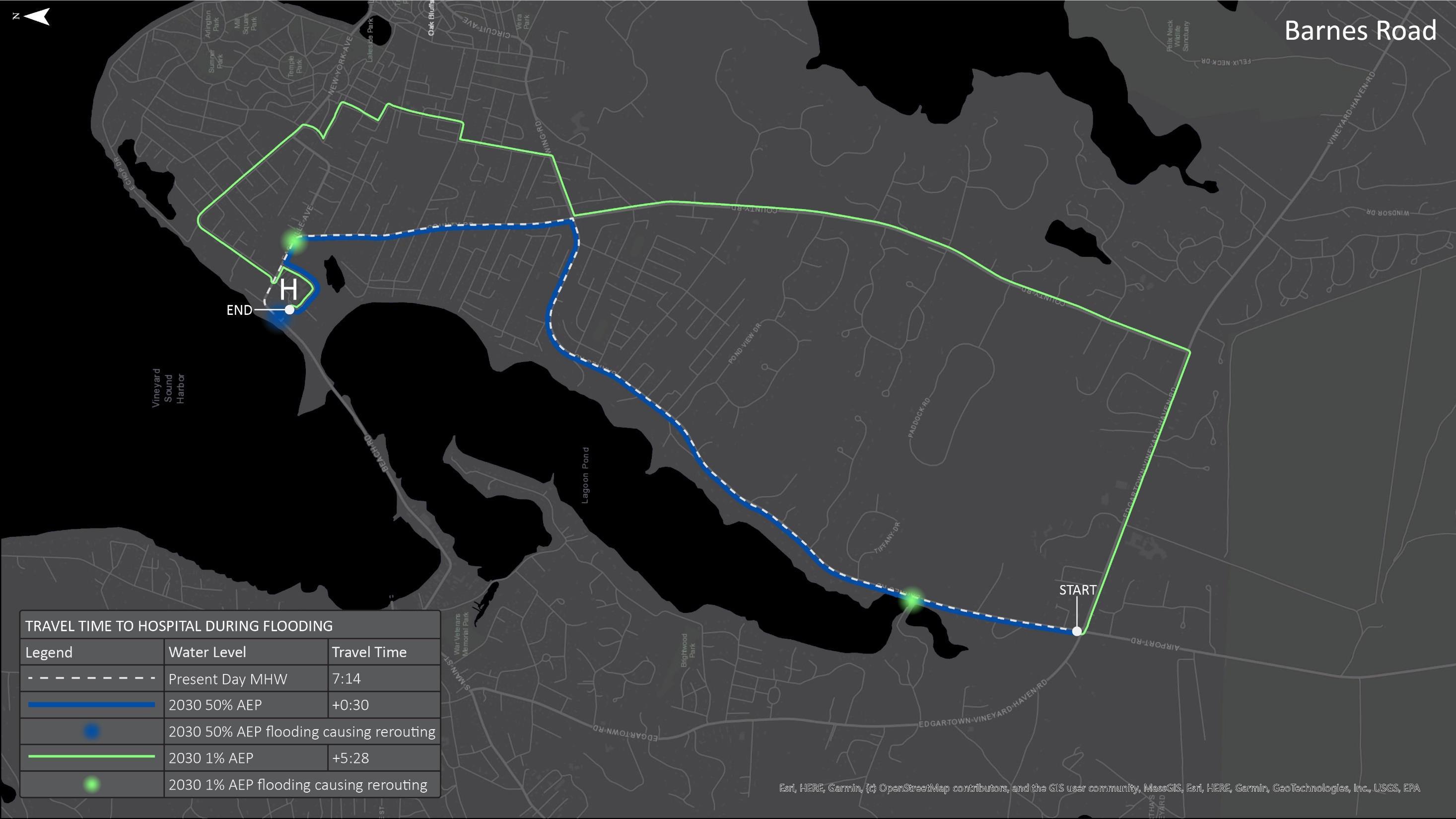

Hospital Route Flood Impact Summary


Origin Travel Time (MM:SS) Flooded Segments Affecting Route Existing Conditions Added by 2030 50% AEP Flooding Added by 2030 1% AEP Flooding Five Corners‡ Beach Road (VH)‡ Beach Road (OB) Barnes Road East Chop Drive Eastville Avenue County Road New York Ave Lake Avenue Dukes County Way Seaview Avenue‡ Vineyard Haven 2:58 8:44 13:26 1% 1% 1% 1% - 1% 1% - - -50% 50% 50% - - - - - - -Oak Bluffs Ferry 3:57 2:57 4:31 - - 1% - - 1% 1% 1% 1% 1%- - 50% - - - - 50% 50% 50%East Chop Road 2:44 2:58 3:00 - - 1% - 1% 1% - - - -- - 50% - 50% - - - - -Harthaven 7:17 0:31 2:42 - - 1% - - 1% 1% - 1% 1% 1% - - 50% - - - - - 50% 50% 50% Barnes Road 7:14 0:30 5:28 - - 1% - - 1% 1% - - -- - 50% - - - - - - -Edgartown-West Tisbury Road 11:00 0:30 5:06 - - 1% 1% - 1% 1% - - -- - 50% - - - - - - -County Road (North at Wing Rd) 2:54 0:30 4:06 - - 1% - - 1% 1% - - -- - 50% - - - - - - -County Road (South at E-VH Rd) 6:54 0:30 3:54 - - 1% - - 1% 1% - - -- - 50% - - - - - - -Edgartown (Upper Main St) 13:54 0:30 3:54 - - 1% - - 1% 1% - - -- - 50% - - - - - - -Linton Avenue 1:56 0:30 1:46 - - 1% - - 1% 1% - - -- - 50% - - - - - - -‡ Segment included in other resiliency projects
‡
Roadway Segment Prioritization Results
included in other resiliency projects
∞ Segment includes area of potential future high tide flooding


Road Segment MassDOT Annual average daily traffic (AADT) Vulnerable Length (ft) Residence Time (hrs) Advisory Considerations Selections Mean High Water 2030 >8" Flood Depth 1% AEP >8" Duration • Planning horizon • Current stormwater impact • Trees, power lines obstacles during storms • Balance realistic routes • # Routes impacted • Hospital give thought to entrances 2030 2050 2070 50% AEP 1% AEP 2030 2050 2070 Five Corners‡ 97621320 1720 1720 1720 8.9 ∞ ∞ Included in other resilience efforts Beach Road (VH)‡ 9762540 3720 3100 4100 9.2 ∞ ∞ Included in other resilience efforts Beach Road (OB) 9762260 1140 800 2180 8.2 ∞ ∞ **Important to all entering the hospital PRIORITY Barnes Road 1000 - -- 320 1.0 2.4 4.1 ** Important to response time for up island PRIORITY East Chop Drive 1000 -2300 1100 2580 8.6 21.2 ∞ Not at top of list, can access from two other directions Eastville Avenue 974- - - 520 4.0 6.5 8.9 **if Beach Rd flooded every ambulance coming this way PRIORITY County Road 1000 - -- 1120 4.1 6.5 9.4 ** if Beach Rd flooded every ambulance coming this way PRIORITY Lake Avenue 9762 - 200 1600 1380 1620 7.8 ∞ ∞ Can get around if needed and doesn’t impact the rest of the island as much as others routes. Dukes County Ave 1000600 1320 920 1660 7.7 ∞ ∞ Unlikely to use as route to hospital More likely used in getting to an emergency Seaview Avenue‡ N/A40 1860 900 2880 6.9 9.1 ∞ Included in other resilience efforts
Segment
RMAT Climate Resilience Design Standards (Barnes)
Resilient Massachusetts Action Team (RMAT)


Significant Wave Crest Elevation SWCE = 14.0 FT NAVD88
RMAT Climate Resilience Design Standards (Eastville/County)

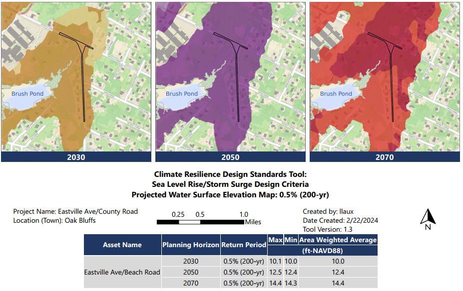
Eastville Rd/County Rd SWCE = 13.6 FT NAVD88
RMAT Climate Resilience Design Standards (Beach)


SWCE = 14.6 FT NAVD88
Priority Segments Review
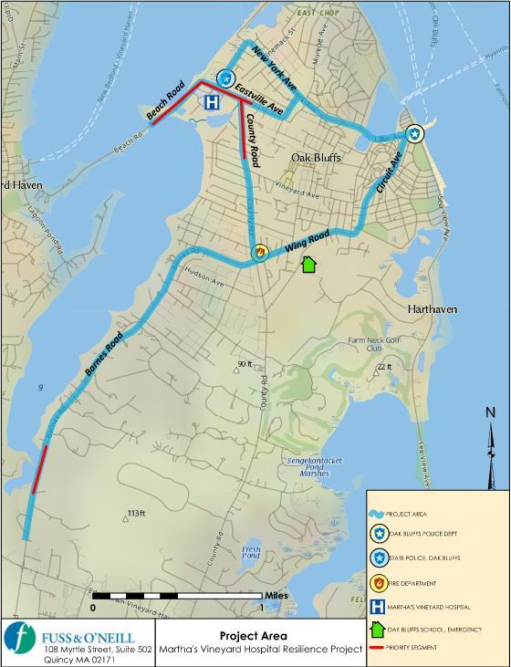
The Priority Roadway Segments (four) were determined by the Advisory Committee and include the following routes where hospital access is restricted:

• Barnes Road
• County Road
• Eastville Avenue
• Beach Road
13
Critical Factors for Adaptation Feasibility

1. Design Flood Elevation & Relative Risk Reduction
2. Available Right of Way & Impacts
a) Private Property Impacts
b) Natural Resource Impacts & Permitting
c) Easements,Takings
d) Maintaining Driveway Access, Keeping Driveway Slopes Under 15%
3. Cost-Benefit
4. Adaptability for the Future
5. Constructability
6. Construction & Property Acquisition Cost

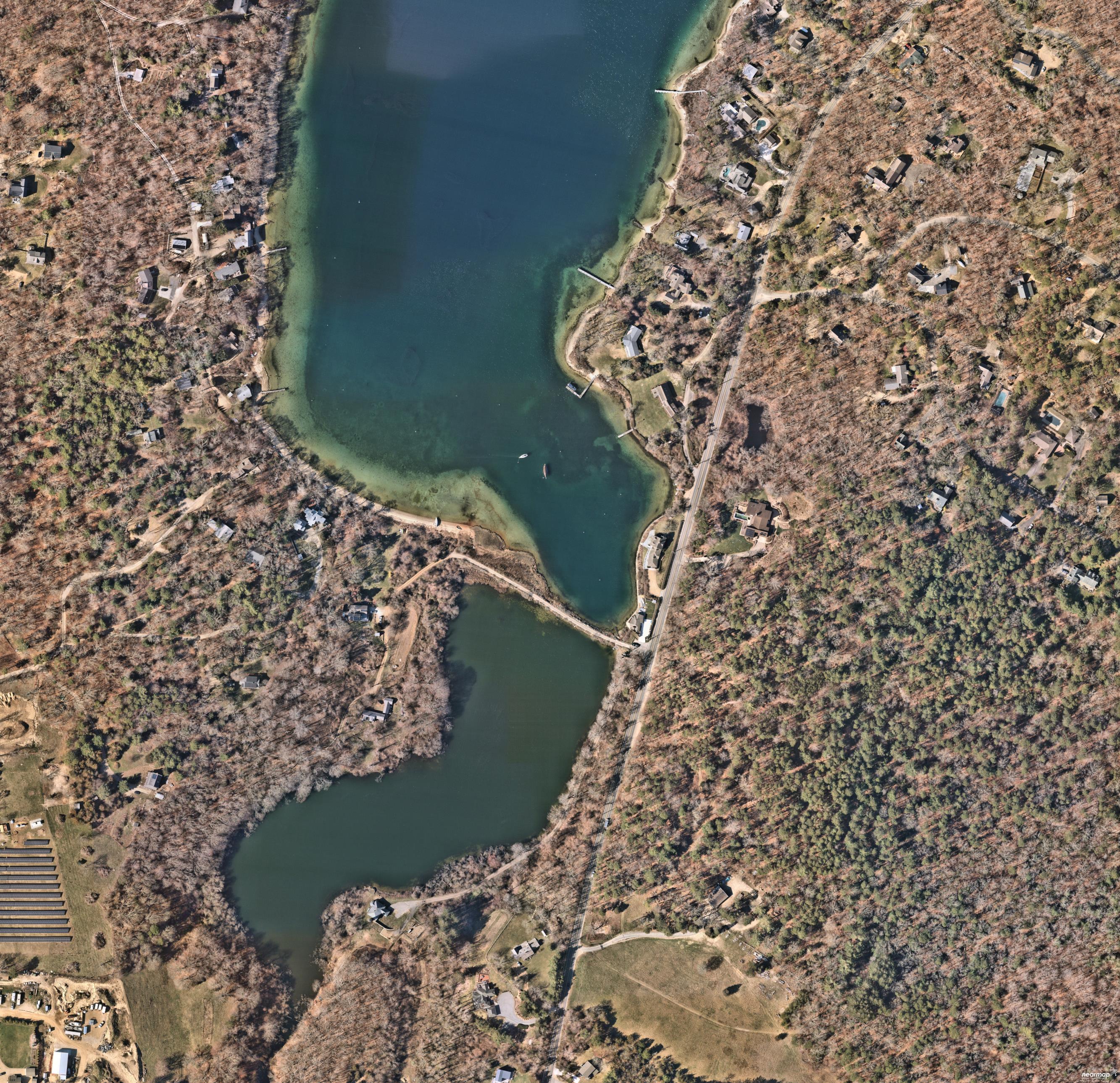
Alternatives Analysis : Barnes Road
15

Barnes Road Alternative #1
Alt #1: Low Impact Road Raising
Design Elevation 13.6 ft
Existing Elevation 9.0 ft
DFE WSE = 13.6' NAVD88 (2050 0.2% WSE)
Significant wave crest elevation = 14.0'
Residual Risk 2030 = 0%; 2050 = 0.1%; 2070 = 0.5%
Challenges Minor grading easements 15% slope driveways
Description Raise road in place and use 2:1 slopes or retaining walls to support

Solutions GI stormwater management, native vegetation stabilized side slopes 16
Cost $3M to $5M Nature Based

Barnes Road Alternative #1


17

Barnes Road Alternative #2
Alt #2: Alignment Shift & Road Raising
Design Elevation 13.6 ft
Existing Elevation 9.0 ft
DFE WSE = 13.6' NAVD88 (2050 0.2% WSE)
Significant wave crest elevation = 14.0'
Residual Risk 2030 = 0%; 2050 = 0.1%; 2070 = 0.5%
Challenges Minor grading easements 15% slope driveways
Description Vegetation Clearing Grading Easements
Retaining Walls Drainage Challenges

Solutions GI stormwater management, native vegetation stabilized side slopes 18
Cost $4M to $6M Nature Based

Barnes Road Alternative #2


19

Barnes Road Alternatives Summary
*Design Flood Elevation for Barnes Road is 13.6 ft (2050, 0.2% water surface elevation)
Alternative Description Maximum Design Elevation* Residual Risk Impacts/ Barriers Cost Range Tidal Flooding 2030 2050 2070 Existing Conditions 9 ft 1% 5% 20% No #1 Low Impact Road Raising Raise road in place to maximum design elevation feasible. 13.6 ft 0% 0.1% 0.5% Steep Driveways (15% grade max) Grading Easements $3M to $5M No
Alignment Shift & Road Raising Shift roadway approximately 510 ft to the east and raise the roadway to a target elevation. 13.6 ft 0% 0.1% 0.5% Vegetation Clearing Grading Easements Retaining Walls Drainage Challenges $4M to $6M No
#2
20


Alternatives Analysis : County Road
21

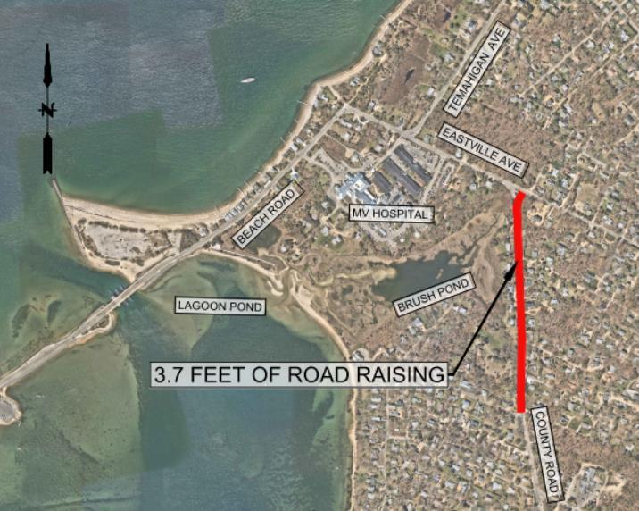
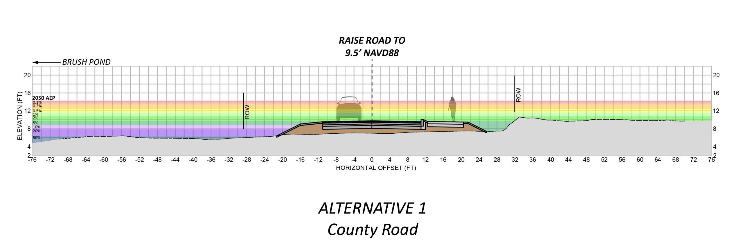
County Road Alternative #1
Alt #1: Low Impact Road Raising
Design Elevation 9.5 ft
Existing Elevation 5.8 ft
DFE WSE = 12.4' NAVD88 (2050 0.5% WSE)
Significant wave crest elevation = 13.6'
Residual Risk 2030 = 0.5%; 2050 = 5%; 2070 =20%
Challenges Raise road in place to maximum design elevation feasible.
Description Steep Driveways (15% grade max)
Grading Easements
Cost $4M to $6M
Nature Based Solution Native vegetation stabilized side slopes; enhance Brush Pond barrier beach/dune; marsh migration culvert under County/Eastville intersection
22

County Road Alternative #1

23

County Road Alternative #2
Alt #2: Alignment Shift & Road Raising
Design Elevation 12.4 ft
Existing Elevation 5.8 ft
DFE WSE = 12.4' NAVD88 (2050 0.5% WSE)
Significant wave crest elevation = 13.6'
Residual Risk 2030 = 0%; 2050 = 0.2%; 2070 =2%
Challenges Steep Driveways (18% max grade)
Grading Easements
Drainage Challenge
Description Shift County Road to the east the bike path to the west side of the road.

$5M to $7M
beach/dune; marsh migration culvert 24
Cost
Nature Based Solution Native vegetation stabilized side slopes; enhance Brush Pond barrier

County Road Alternative #2


25

County Road Alternative #3
Alt #3: Maximum Flood Protection
Design Elevation 14.0 ft
Existing Elevation 5.8 ft
DFE WSE = 12.4' NAVD88 (2050 0.5% WSE)
Significant wave crest elevation = 13.6'
Residual Risk 2030 = 0%; 2050 = 0.1%; 2070 = 0.5%
Challenges ROW acquisition
Residential Structure Demolition
Description Acquire properties on the west side and use space for road raising or berm.
Cost $6M to $8M with $10M to $15M in Property Acquisition
Nature Based Solution Native vegetation stabilized side slopes; enhance Brush Pond barrier beach/dune; marsh migration culvert under County/Eastville intersection, habitat and open space park

26

County Road Alternative #3


27

County Road Alternatives Summary
Alternative Description Maximum Design Elevation Residual Risk Impacts/ Barriers Cost Range Tidal Flooding 2030 2050 2070 Existing 5.8 ft 20% 50% 50% No #1 Low Impact Road Raising Raise road in place to maximum design elevation feasible. 9.5 ft 0.5% 5% 20% Steep Driveways (15% grade max) Grading Easements $4M to $6M No #2 Alignment Shift & Road Raising Shift County Road to the east the bike path to the west side of the road and raise the road. 12.4 ft <0.1% 0.2% 2% Steep Driveways (18% max grade) Grading Easements Drainage Challenge $5M to $8M No #3 Maximum Flood Protection Acquire properties on the west side and use space for road raising or berm. 14 ft <0.1% 0.1% 0.5% ROW acquisition Residential Structure Demolition $6M to $9M with $10M to $15M Property Acquisition No *Design Flood Elevation for County Road is 12.4 ft (2050, 0.5% water surface elevation) 28


Alternatives Analysis : Eastville Ave
29

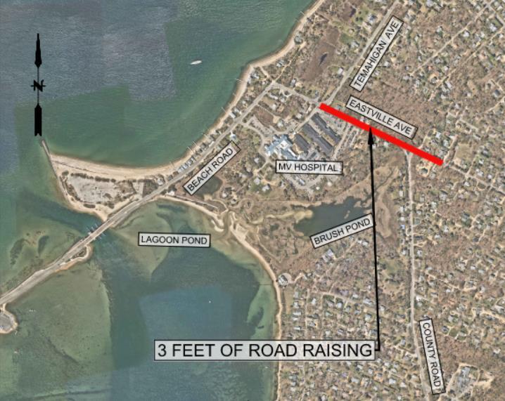
Eastville Avenue Alternative #1
Alt #1: Low Impact Road Raising
Design Elevation 8.5 ft
Existing Elevation 5.5 ft
DFE WSE = 12.4' NAVD88 (2050 0.5% WSE)
Significant wave crest elevation = 13.6'
Residual Risk 2030 = 2%; 2050 = 10%; 2070 =20%
Challenges Steep driveway (<18% max grade)
Grading easements
Description Raise the road in place to maximum design elevation feasible.
Cost $3M to $5M
Nature Based Solution Native vegetation stabilized side slopes; enhance Brush Pond barrier beach/dune; marsh migration culvert under County/Eastville intersection
30

Eastville Avenue Alternative #1 (rev)


31

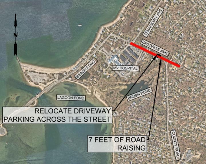
Eastville Avenue Alternative #2
Alt #2: Road Raising & Driveway Relocation
Design Elevation 12.4 ft
Existing Elevation 5.5 ft
DFE WSE = 12.4' NAVD88 (2050 0.5% WSE)
Significant wave crest elevation = 13.6'
Residual Risk 2030 = 0%; 2050 = 0.2%; 2070 =2%
Challenges
Retaining walls
Grading easements
Vegetation Clearing
Removes driveway access to garages
Description Raise the road in place and relocate residential parking
Cost $4M to $6M
Nature Based Solution Native vegetation stabilized side slopes; enhance Brush Pond barrier beach/dune; marsh migration culvert under
32
County/Eastville intersection

Eastville Avenue Alternative #2


33

Eastville Avenue Alternative #3
Alt #3: Road Raising & Realignment
Design Elevation 12.4 ft
Existing Elevation 5.5 ft
DFE WSE = 12.4' NAVD88 (2050 0.5% WSE)
Significant wave crest elevation = 13.6'
Residual Risk 2030 = 0%; 2050 = 0.2%; 2070 =2%
Challenges ROW acquisition
Drainage challenges
Vegetation Clearing Steep driveways (15% max grades)
Description Shift road to the east onto the undeveloped properties and raise the road
Cost $5M to $7M with $1M to $3M in property acquisition
Nature Based Solution Native vegetation stabilized side slopes; enhance Brush Pond barrier beach/dune; marsh migration culvert under County/Eastville intersection

34

Eastville Avenue Alternative #3


35

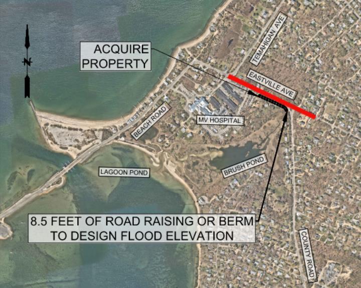
Eastville Avenue Alternative #4
Alt #4: Road Raising & Realignment
Design Elevation 14.0 ft
Existing Elevation 5.5 ft
DFE WSE = 12.4' NAVD88 (2050 0.5% WSE)
Significant wave crest elevation = 13.6'
Residual Risk 2030 = 0%; 2050 = 0.1%; 2070 = 0.5%
Challenges ROW acquisition and residential structure demolition
Description Acquire properties along the road and use space for road raising or berm.
Cost $6M to $8M with $2M to $4M property acquisition
Nature Based Solution Native vegetation stabilized side slopes; enhance Brush Pond barrier beach/dune; marsh migration culvert under County/Eastville intersection, habitat and open space park
36

Eastville Avenue Alternative #3


37

Eastville Avenue Alternatives Summary
Alternative Description Maximum Design Elevation Residual Risk Impacts/ Barriers Cost Range Tidal Flooding 2030 2050 2070 Existing 5.5 ft 20% 50% 50% No #1 Low Impact Road Raising Raise the road in place to maximum design elevation feasible. 8.5 ft 2% 10% 20% Steep driveways (<18% max grade) Grading easements $3M to $5M No #2 Road Raising & Driveway Relocation Raise the road in place and relocate residential parking. 12.4 ft <0.1% 0.2% 2% Retaining walls Grading easements Removes driveway access to garages $4M to $6M No #3 Alignment Shift & Road Raising Shift road to the east onto the undeveloped properties and raise the road. 12.4 ft <0.1% 0.2% 2% ROW acquisition Permitting required Drainage challenges Steep driveways (<15% max grades) $5M to $8M with $1M to $3M property acquisition No #4 Maximum Flood Protection Acquire properties along the road and use space for road raising or berm. 14.0 ft <0.1% 0.1% 0.5% ROW acquisition and residential structure demolition $6M to $9M with $2M to $4M property acquisition No *Design Flood Elevation for Eastville Road is 12.4 ft (2050, 0.5% water surface elevation) 38


Alternatives Analysis : Beach Road
39

Beach Road Alternative #1
Alt #1: Low Impact Road Raising
Design Elevation 8.0 ft
Existing Elevation 3.0 ft
DFE WSE = 12.4' NAVD88 (2050 0.5% WSE)
Significant wave crest elevation = 14.6'
Residual Risk 2030 = 2%; 2050 = 10%; 2070 = 50%
Challenges Minor grading easements 15% slope driveways
Description Raise the road in place to maximum design elevation feasible.
Cost $3M to $5M
Nature Based
Solution Native vegetation stabilized side slopes

Note: Short term feasibility to raise between Temahigan Ave and Hospital Entrance
40

Beach Road Alternative #1


41

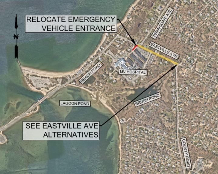
Beach Road Alternative #2
Alt #2: Relocate Hospital Emergency Entrance
Design Elevation 12.4 ft (at new entrance only)
Existing Elevation 3.0 ft
DFE WSE = 12.4' NAVD88 (2050 0.5% WSE)
Significant wave crest elevation = 14.6'
Residual Risk 2030 = 0%; 2050 = 0.2%; 2070 = 2%
Challenges Reconstruction required on hospital property and does not raise majority of road. Best combined with Eastville Ave alternatives.
Description Relocate emergency vehicle entrance and parking lots west of Temahigan Road.
Cost $1M to $3M
Nature Based Solution N/A
42

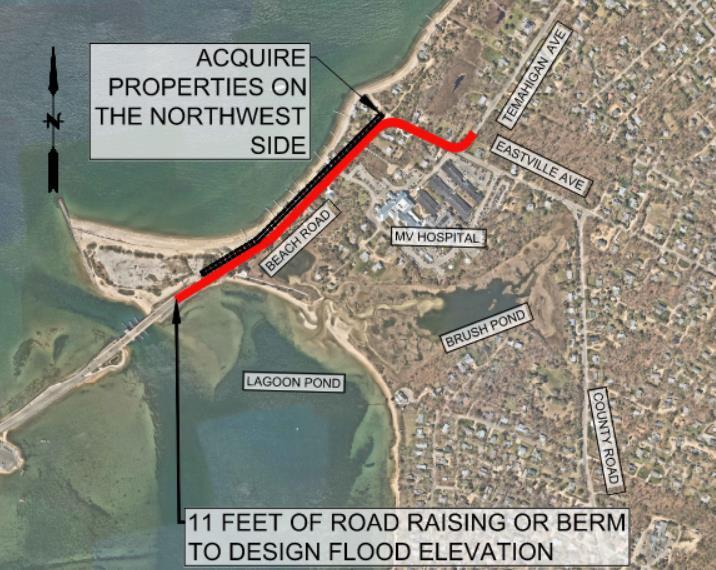
Beach Road Alternative #3
Alt #3: Maximum Flood Protection
Design Elevation 14.5 ft
Existing Elevation 3.0 ft
DFE WSE = 12.4' NAVD88 (2050 0.5% WSE)
Significant wave crest elevation = 14.6'
Residual Risk 2030 = 0%; 2050 = 0.2%; 2070 = 2%
Challenges ROW acquisition and residential structure demolition
Description Acquire properties and use space for road raising or berm.
Cost $3M to $5M
Nature Based
Solution Native vegetation stabilized side slopes; enhance Eastville barrier beach/dune, Vineyard Haven Harbor wave attenuation strategies; enhance Brush Pond barrier beach/dune
43

Beach Road Alternative #3


44

Beach Road Alternatives Summary
Alternative Description Maximum Design Elevation Residual Risk Impacts/ Barriers Cost Range Tidal Flooding 2030 2050 2070 Existing 3.0 ft 50% 50% 50% 2050 #1 Low Impact Road Raising Raise the road in place to maximum design elevation feasible. 8.0 ft 2% 10% 50% Steep Driveways (15% grade max) and grading easements $3M to $5M No #2 Relocate Hospital Emergency Entrance Relocate Emergency Vehicle entrance and parking lots to the west of Temahigan Road. 12.4 ft (at new entrance only) 0% 0.2% 2% Reconstruction required on hospital property and does not raise majority of road. $1M to $3M No #3 Maximum Flood Protection Acquire properties and use space for road raising or berm. 12.4 ft 0% 0.2% 2% ROW acquisition and residential structure demolition $5M to $7M with $20M to $30M Property Acquisition No *Design Flood Elevation for Beach Road is 12.4 ft (2050, 0.5% water surface elevation) 45

Preferred Alternative Discussion
46
Segment Preferred Alternative Considerations Barnes Road County Road Eastville Avenue Beach Road

Schedule & Next Steps
• Remaining Work − Preferred alternative development for each segment
• Conceptual design
• Detailed plan view & cross sections
• Permitting considerations − Phased approach overview
• June 1 – Public Forum
• June 11th Selectboard Presentation
• June 15th Final (draft report) to Coastal Zone Management
• June 30th – Final Report
47
https://tinyurl.com/MVHospitalResilience SAVE THE DATE
June 1 – Public Presentation
June 11th Selectboards Presentation

Project Website


Engineers | Scientists | Planners


Engineers | Scientists | Planners Thank You! Eileen Gunn, Project Manager egunn@fando.com www.fando.com


 H Beach Rd (OB)
Five Corners
Lake Ave East Chop Rd


