WATERSHED CONTEXT
| 1

WATERSHED POPULATION
HOW MUCH OF THE WATERSHED DOES EACH MUNICIPALITY COMPRISE?
WHAT PERCENTAGE OF EACH MUNICIPALITY IS WITHIN THE NBPR WATERSHED?
WATERSHED AREA 28.6
BRANCH
GROUND)
The area along the North Branch Park River, which includes the floodplain, riparian area, and adjacent uplands, is a key integrating feature for green infrastructure.
A floodplain is the area of land next to a river or stream that is susceptible to being inundated by floodwaters. Floodplains provide important social, economic and ecological functions such as floodwater storage and movement, groundwater recharge, water quality protection (trapping of sediment and nutrients), and wildlife and fish habitat. Floodplains are also places where people, human structures, and critical transportation infrastructure can be vulnerable to disruption and damage.
The regulatory floodplain, also referred to as the flood hazard area or zone, is the flood prone area adjacent to a river or stream defined by the return period of its inundation. For example, the 100-year floodplain corresponds to the area inundated by the flood with a return period of 100 years or a 1 percent chance of occurring in any given year (1 percent Annual Exceedance Probability).
The adjacent figure shows the 100-year and 500-year regulatory floodplains, as mapped by the Federal Emergency Management Agency (FEMA), for the North Branch Park River subwatershed.


Riparian areas are the transition zone between terrestrial and aquatic systems and typically include streambanks, floodplains, wetlands and other systems adjacent to rivers and streams. Riparian areas characteristically have high water tables and are subject to periodic flooding. Healthy riparian areas (i.e., characterized by stable, healthy vegetation) have high ecological diversity, can maintain or improve water quality, and have both recreational and economic benefits.
The riparian corridor encompasses riparian areas, as well as adjacent upland areas needed to protect or restore riparian function. For example, steep erodible slopes that could adversely affect the riparian area or the stream are included in the riparian corridor (see adjacent figure for steep slope areas along the North Branch Park River).
The management goal for riparian corridors is to maintain or restore the area to a vegetated condition to help filter pollutants and to protect riparian habitat and species. Mitigation measures can be located within the riparian corridor to protect water quality and riparian values.


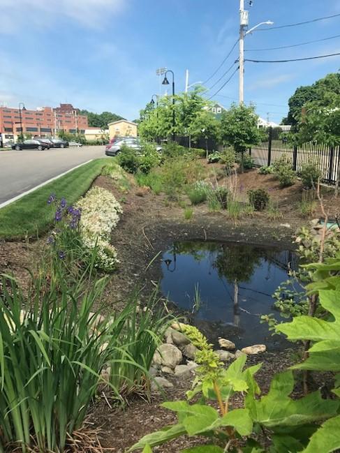
Green Infrastructure (GI) refers to natural and man-made landscapes and practices that reduce stormwater runoff using vegetation, soils, and natural processes to manage water and create healthier urban and suburban environments. These practices capture, manage, and/or reuse rainfall close to where it falls, reducing stormwater runoff and keeping it out of drainage systems, combined sewer systems, and receiving waters.
Examples of natural green infrastructure include forests, meadows, and floodplains and land conservation strategies to preserve these features in a natural or undeveloped state. Examples of man-made green infrastructure include Green Stormwater Infrastructure (GSI) for managing
stormwater runoff at the site or neighborhood scale, such as bioswales, rain gardens, green roofs, and rainwater harvesting, as well as other types of designed green infrastructure such as urban tree canopy, floodplain and riparian corridor restoration and conservation, and urban rewilding.
In addition to reducing runoff and improving water quality, green infrastructure has been shown to provide many other social and economic benefits as highlighted in the following graphic.


 The multiple benefits of green infrastructure (Source: Carbon180).
Green Stormwater Infrastructure (GSI)
Infiltration basins
Bioretention systems
Bioretention Planters Parking Lot Bioretention
Bioretention & Walking Trails Rain Gardens
Roadside Bioswales Green Streets
Urban Tree CanopySmall Urban Forests & Urban Rewilding
Riparian & Floodplain Restoration
The multiple benefits of green infrastructure (Source: Carbon180).
Green Stormwater Infrastructure (GSI)
Infiltration basins
Bioretention systems
Bioretention Planters Parking Lot Bioretention
Bioretention & Walking Trails Rain Gardens
Roadside Bioswales Green Streets
Urban Tree CanopySmall Urban Forests & Urban Rewilding
Riparian & Floodplain Restoration
Restore riparian areas and floodplains currently occupied by parking lots and other flood prone development to re-establish natural ecological system processes and functions (water quality, habitat, flood reduction, etc.). Restoration of these areas would involve converting portions of the existing parking lots to a more natural condition and function by removing the man-made infrastructure, removing non-native vegetation, amending the soils, and planting native trees and shrubs. Other modifications to the streambanks, riparian area, and floodplain may be warranted to re-connect the stream to its floodplain and restore lost hydrologic function and habitat.
Protect or preserve land in a natural or undeveloped state through acquisition and/or conservation easement or other type of conservation restriction. Target existing undeveloped parcels along riparian corridors and in headwater areas, as well as areas proposed for riparian and floodplain restoration.
• Loss of existing parking and future development potential
• Voluntary cooperation of property owners
• Strategies and incentives to reduce parking and other impervious cover such as shared parking, stormwater user fee and credit system, and structured parking


LAND CONSERVATION OF FLOODPLAIN, RIPARIAN CORRIDOR, AND WOODED STEEP SLOPES
FLOODPLAIN AND RIPARIAN CORRIDOR, INCLUDING WOODED STEEP SLOPES

RIPARIAN/FLOODPLAIN
FLOODPLAIN

 RESTORATION OF EXISTING PARKING LOTS
RESTORATION OF EXISTING PARKING LOTS
RESTORATION OF EXISTING PARKING LOTS
Retrofit existing impervious surfaces with bioswales, rain gardens, infiltration systems, green roofs, and other green stormwater infrastructure (GSI) practices. Numerous GSI retrofit opportunities exist on public and institutional properties within the North Branch Park River subwatershed including parking lots, schoolyards, and along roads (green streets). Opportunities also exist for installation of larger subsurface storage and infiltration systems below athletic fields and parking lots.
Several areas of the watershed with combined sewers are slated for future sewer separation (e.g., Granby Street and Blue Hills neighborhood), creating the opportunity to incorporate GSI into the right-of-way (green streets) as part of the sewer separation and GSI treatment of new separated stormwater discharges that will serve these areas.
• Voluntary cooperation of property owners
• Combined sewers in a large portion of the subwatershed. MDC currently prohibits the use of open-bottom stormwater infiltration systems in combined sewer areas due to concerns about groundwater potentially entering the combined sewer system through stormwater infiltration systems.
• Portions of the watershed are underlain by soils with low infiltration capacity (clay soils) and a high groundwater table, which are challenging site conditions for implementation of infiltration-based GSI. This underscores the importance of careful GSI selection and design.
• Strategies and incentives to reduce impervious cover such as stormwater user fee and credit system


Create walking paths and trails within restored riparian/floodplain areas to connect area schools, institutional facilities, and landscapes to the river corridor and to the proposed Hartline multi-use trail. Boardwalks could be used within the restored floodplain to elevate the walking paths above the flood elevation.
Existing sidewalks, as well as new side paths and bicycle lanes added along existing roads, could provide connections between the walking path/trail network and existing or proposed green spaces in the watershed. The proposed walking paths/trails and green streets can also serve as cooling corridors by providing shaded routes for walking and bicycling.
There are numerous road crossings (culverts and bridges) of the North Branch Park River and its tributaries. These crossings have the potential to restrict wildlife (terrestrial and aquatic) passage, restrict flood flows and act as choke points for trees and debris, and contribute to erosion and degraded water quality. The road-stream crossings in the watershed should be evaluated for potential upgrade/replacement and related stream restoration.
Challenges
• Voluntary cooperation of property owners
• Public concern over proposed walking paths/ trails
• Engineering and fluvial geomorphic evaluation of river and road-stream crossings


EVALUATE RIVER CROSSING FOR REPLACEMENT


 WALKING PATHS IN RESTORATION AREAS
TRAIL CONNECTIONS
WALKING PATHS IN RESTORATION AREAS
TRAIL CONNECTIONS


CONNECTICUT MUSEUM OF CULTURE AND HISTORY
CLASSICAL MAGNET SCHOOL
CONNECTICUT COMMUNITY COLLEGES
POLLINATOR GARDEN

FLOODPLAIN RESTORATION WITHIN EXISTING PARKING LOTS
SUBSURFACE STORMWATER STORAGE
HARTFORD INTERNATIONAL UNIVERSITY FOR RELIGION AND PEACE
GREEN STORMWATER INFRASTRUCTURE (TYP)
GREEN STREETS (TYP)
LAND CONSERVATION

FLOODPLAIN RESTORATION WITHIN EXISTING PARKING LOTS
GOODWIN CIRCLE
WOODSIDE CIRCLE
SUBSURFACE
STORMWATER STORAGE
LAND CONSERVATION
CONNECTICUT MUSEUM OF CULTURE AND HISTORY
EVALUATE EXISTING STREAM CROSSING (TYP)
CLASSICAL MAGNET SCHOOL
CONNECTICUT COMMUNITY COLLEGES
CSO N-9
EVALUATE EXISTING STREAM CROSSING (TYP)

FLOODPLAIN RESTORATION
PROPOSED SIDE PATH
GREEN STREETS IN FUTURE SEWER SEPARATION AREA (TYP)
EVERSOURCE ELECTRICAL SUBSTATION

GREEN STORMWATER INFRASTRUCTURE WITH BROWNFIELD REDEVELOPMENT
FLOODPLAIN RESTORATION WITH FUTURE SITE REDEVELOPMENT
LAND CONSERVATION

FUTURE HARTLINE MULTIUSE TRAIL
GREEN STREET SCARBOROUGH STREET GOODWIN’S WILD (OLD GROWTH FOREST)
HANDEL PERFORMING ARTS CENTER AT UNIVERSITY OF HARTFORD
GSI WITHIN PARKING LOTS (TYP)
GREEN STREETS IN FUTURE SEWER SEPARATION AREA (TYP)
GREEN STORMWATER INFRASTRUCTURE WITH BROWNFIELD REDEVELOPMENT
FUTURE HARTLINE MULTIUSE TRAIL
GSI WITHIN PARKING LOTS (TYP) ALBANY BRANCH

WALKING TRAIL
UNIVERSITY HIGH SCHOOL OF SCIENCE & ENGINEERING

UNIVERSITY OF HARTFORD MAGNET SCHOOL
GSI WITHIN PARKING LOTS (TYP)
LAND CONSERVATION
FISHER MONTESSORI MAGNET SCHOOL

GREEN STREET ALONG MARK TWAIN DRIVE ONGOING PHASED REDEVELOPMENT WITH LID/GSI

FUTURE HARTLINE MULTI-USE TRAIL

EVALUATE EXISTING RIVER CROSSING (TYP)
LAND CONSERVATION –RIPARIAN AREA OF TRIBUTARY TO NORTH BRANCH PARK RIVER

GSI AT EXISTING STORM DRAIN OUTFALL (TYP)
GSI WITHIN PARKING LOTS (TYP)

GSI WITHIN PARKING LOT ISLANDS AND EDGES (TYP)
GREEN STREETS IN FUTURE SEWER SEPARATION AREA (TYP)
SUBSURFACE STORAGE SYSTEM BENEATH ATHLETIC FIELDS TO MANAGE STORMWATER FROM FUTURE SEPARATE STORM DRAINAGE SYSTEM

ST
LYME

EVALUATE EXISTING STREAM CROSSING (TYP)

FLOODPLAIN RESTORATION OF UHART PARKING LOT


EVALUATE EXISTING STREAM CROSSING (TYP)
FUTURE HARTLINE MULTI-USE TRAIL
GSI WITHIN PARKING LOT (TYP) GSI WITHIN PARKING LOT (TYP) GREEN STREET (TYP)
GSI ALONG PARK ROADS AND PARKING LOTS (TYP) ROADS AND IN
ENHANCED POND BUFFER
ELIZABETH PARK ROSE GARDEN
INTEGRATE GSI INTO FUTURE PARK IMPROVEMENTS CONSISTENT WITH UPDATED MASTER PLAN FOR ELIZABETH PARK EAST