11 minute read
Realistic Virtual Reality Environments from Point Clouds


ImmersIve and InteractIve surveyIng Labs
The advent of cost-effective head-mounted displays marked a new era in immersive virtual reality and sparked widespread applications in engineering, science and education. An integral component of any virtual reality application is the virtual environment. While some applications may have a completely imaginary virtual environment, others require the realistic recreation of a site or building. Relevant examples can be found in gaming, heritage site preservation and building information modelling. This article discusses how point cloud technologies were used to create a realistic virtual environment for use in immersive and interactive surveying labs.
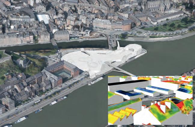
Creating a virtual environment that is based on a physical site necessitates geometric information to a high level of detail. Technologies such as unmanned aerial systems (UASs) and terrestrial laser scanning (TLS) generate dense and accurate 3D point clouds. Each method offers advantages and disadvantages that complement each other. For example, a UAS maps at an altitude with a downward-looking view angle, while scanners are set at vantage locations limited by lineof-sight obstructions. Identifying data gaps and merging their point clouds can create datasets that are more complete. For research purposes, a recent study recreated part of the Penn State Wilkes-Barre campus. The authors conducted UAS flights with nadir imaging and collected TLS scans from various locations, mostly around the building, and merged the point clouds through a custom merging algorithm. Figure 1 shows an example of the data gaps in the UAS and TLS datasets. For example, in this case the UAS point cloud has gaps around tree areas and captured the top of the building but not its vertical walls. In contrast, the TLS dataset could not capture the top of the building but did capture the building’s vertical walls. The TLS dataset was used as the reference and consisted of 180 million points. The UAS point cloud had 70 million points, and 25 million points were kept to fill gaps in the TLS dataset.
Modelling the terrain and structures
The terrain and any man-made structures can be modelled based on the merged point cloud. Using existing segmentation algorithms, it is relatively easy to separate the point cloud into ground and non-ground and create a terrain mesh from the ground points. While detail meshes of several million faces can be created, this introduces challenges to game engines (such as Unity and Unreal) that are often used to create virtual environments. For a pleasant virtual experience, it is important to always maintain a minimum of 60 frames per second (FPS), while other virtual-reality hardware manufacturers often recommend at least 90 FPS. This means that
Figure 2: Modeling of Terrain (left) and man-made objects (right).

Figure 3: Top view of the virtual environment.

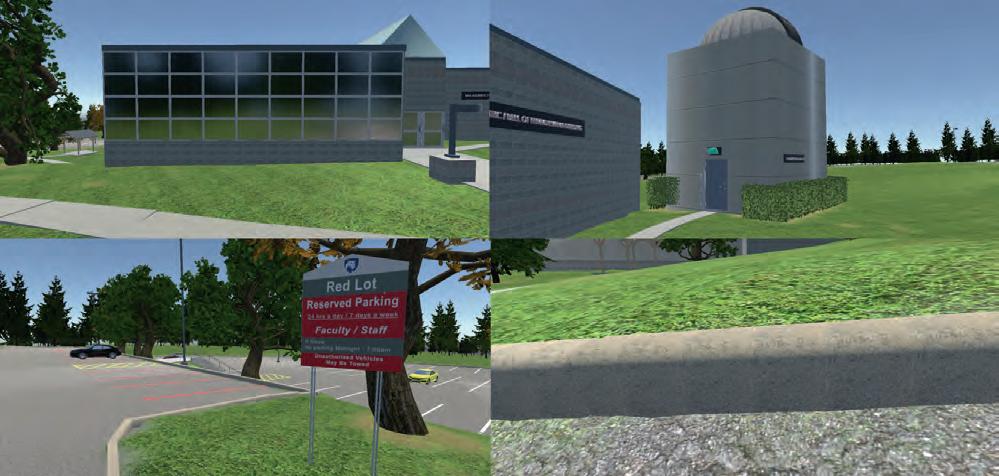
Figure 4: Examples of texture and environment. View of the Bell Technology Center (top left); Friedman Observatory (top right); Faculty and staff car park (bottom left); kerb, grass and asphalt textures (bottom right).
detailed meshes of a few million faces need to be simplified to a few thousand without compromising the accuracy of the terrain. For example, in this implementation the initial terrain mesh had 4 million faces; however, when approaching complex areas (such as around the building), the FPS dropped to less than 60. The authors simplified the terrain and used 50,000 faces with a difference of 5cm in root mean square error (RMSE). Figure 2 (left) shows this simplified terrain. The terrain mesh was then converted to a Unity Terrain to take advantage of Unity’s occlusion-culling rendering process. This only renders objects that are visible in the user’s field of view, thus ensuring that 90 FPS is consistently maintained.
It was time-consuming to geometrically model man-made structures such as buildings and curbs. While some automatic shape detection algorithms exist, they detect primitive shapes such as boxes, spheres, cylinders and so on. While these are sufficient for applications that do not require a high level of modelling detail, this is not acceptable for immersive virtual environments. Consider that a building has complex windows and door structures, arched walkways, handrails, car-park stripes, letter markings on asphalt (e.g. ‘STOP’) and so on. In this case, man-made objects were modelled manually from the point cloud, which was laborious. Figure 2 (right) shows an example of these 3D models in Autodesk 3DS Max. The accuracy of the modelled 3D structures was compared with 93 checkpoints on building corners and car-park stripes, which showed an agreement within 10-20cm. Improved shape detection algorithms in the future will enhance the automation of structure extraction from point clouds, making it an easier process. For trees, a different approach was followed. A tree random generator (from Unity’s Asset store) was used and they were placed on the corresponding locations, identified from the merged point cloud.
textures
Textures are an essential component of virtual environments. Creating and applying textures that look like their physical counterparts creates a sense of realism. While point clouds give important geometric information, images captured using UASs and TLS do not have sufficient resolution to create textures. As users can get very close to 3D objects in virtual reality, they will be able to see the pixels from the aerial imagery. Built-in materials in game development software can be used if they are similar enough to their physical counterparts, which can be an easy solution. This is the case for asphalt and grass textures. However, some physical objects – such as exterior building walls – have unique and complicated patterns, so textures need to be developed from scratch. To create such textures, the authors used close-up photography and created patterns that resemble the physical ones in Adobe Photoshop.
It is important that these textures are accompanied by normal maps that give an illusion of depth in virtual reality. The textures were used to create materials that were then applied to the 3D objects. Figure 3 shows a top view of the virtual environment created, while Figure 4 shows close-up examples of the textures. Of note are the custom textures in the buildings and the surrounding environment. For instance, in Figure 4 (top left), the windows were made reflective and in Figure 4 (bottom left), the car-park sign was faithfully recreated. In addition, ambient sounds were added such as birds and the movement of tree branches and rustling leaves in the wind. These add realism, which is important to create a sense of immersion.
research results
This article has presented a workflow for utilizing point cloud technologies to create realistic virtual environments. The authors plan to use such realistic environments in surveying labs in immersive and interactive virtual reality. Merging point clouds generated from different acquisition methods can be used to obtain complete and high-detail geometric information. 3D modelling and texturing are important steps to make the environment realistic, but these processes take time and effort. Virtual reality technology is rapidly advancing and is quickly finding its way into surveying and engineering, increasing the demand for replicating physical environments into virtual ones, and opening the door for new professional endeavours.
acknowledgeMents
This project has been supported via grants from the following sources: Schreyer Institute for Teaching Excellence of the Pennsylvania State University, the Engineering Technology and Commonwealth Engineering of the Pennsylvania State University, and Chancellor Endowments from Penn State Wilkes-Barre. Students John Chapman, Vincent F. Pavill IV, Eric Williams, Joe Fioti, Donovan Gaffney, Brandon Fino, Seth St. Clair, Malcolm Sciandra, Courtney Snow and adjunct Brandi Brace are acknowledged for their involvement in this research.
Further readIng
- bolkas, d., chiampi, J., chapman, J., & Pavill, v. F. (2020). creating a virtual reality environment with a fusion of sUaS and tlS point clouds. International Journal of Image and Data Fusion, 1-26. - bolkas, d., chiampi, J., chapman, J., Fioti, J., & Pavill iv, v. F. (2020). creating immersive and interactive Surveying laboratories in virtual reality: a differential leveling example. ISPRS Annals of Photogrammetry, Remote Sensing & Spatial Information Sciences, 5(5).
about the authors
dr dimitrios Bolkas is an assistant professor of surveying engineering at the Pennsylvania State University, Wilkes-barre campus. He holds a Phd in geological sciences and engineering from Queen’s University, Kingston, canada. He has wide-ranging geomatics experience that includes unmanned aerial systems and terrestrial, mobile and airborne laser scanning. His recent research endeavours focus on creating virtual environments from point cloud data and using virtual reality to enhance engineering education. dr bolkas is a director on the executive board of the Surveying and Geomatics educator’s Society (SaGeS). dxb80@psu.edu
Jeffrey chiampi is an assistant teaching professor of engineering at the Pennsylvania State University, Wilkes-barre campus. He holds master’s degrees in business administration and software engineering. at Penn State, he teaches courses in computer science, game development and information sciences and technology, sits on several university committees and conducts research. His primary research interest is the application of virtual reality to engineering education. He regularly involves undergraduate students in his research and often collaborates with faculty from other locations and disciplines. jdc308@psu.edu


Bright Perspectives of Mapping from Above
Recent technological developments have made aerial surveying more exciting than ever. For imagery, ground resolutions of 2cm can now be reached, whereas for Lidar, pulse frequencies of 4GHz and point clouds of 30-40 points/m2 are no longer unusual. Simultaneous acquisition of imagery and Lidar is becoming increasingly popular.
To optimize the production chain and improve the workflow, many survey companies are looking to artificial intelligence (AI) and deep learning (DL) as the holy grail. Given the impressive amount of training data available, the continuously better performing CPUs and GPUs and the many hours of research invested in this subject, there is no doubt that AI and DL will play a bigger role in our industry in the near future. For example, the automatic extraction of trees remains a challenge many would like to tackle, and Eurosense is obtaining good results in that regard. However, AI is not magic, so it would be wise to exercise a certain level of caution in its application. The combination of recent technological developments and workflow improvements has led to better, faster and more accurate 3D models, pushing the limits towards (textured) LOD 3.3 and making an array of applications accessible to more customers every day. Such applications of 3D city models in GIS environments include automatic approval of building permits and complex analysis such as green-roof potential, water storage capacity and air pollution simulations. In
these challenging times due to COVID-19, we are all encouraged to work from home and substantially limit the number of site visits. With a precise and recent 3D model, we can visualize and analyse a virtual clone of the reality, dubbed a ‘digital twin’, from behind our desks instead.
To build the ultimate 3D model, aerial 3D models (based on Lidar and imagery captured from the sky) could be completed with thermography and in situ data. The main challenges encountered in this regard are the different workflows and accuracies to deal with, and the automatic vectorization of Lidar point clouds. A right balance between XYZ accuracy, and time as well as cost, will have to be found.
Recently our industry has witnessed an improvement in the ‘look and feel’ of 3D models. An aesthetically attractive, interactive and immersive model reaches a wider public as it increases engagement, improves understanding and optimizes the experience. Rich 3D models lead to strong visual communication, superior insights and better decisions.
Sharing the 3D model with a broad audience is also an important part of a successful 3D model. Esri software offers an integrated platform for 3D visualization and analysis, and also makes the link with building information modelling (BIM) and indoor mapping. To add an extra dimension, Internet of Things (IoT) sensors can easily be integrated in the 3D model and dashboards to provide real-time information.
In conclusion, Eurosense sees a bright future for ‘mapping from above’, especially with regards to 3D products and applications. Demand is continuously increasing for better 3D products, and technological evolutions make a larger offering available at a more attractive price. These are exciting times indeed for our sector, and… the sky is the limit!
About the Author
Victoria Jadot is project manager at eurosense. She holds a degree in business engineering (from Solvay business School) and in applied geomatics (from Uc louvain). Prior to joining eurosense, she was a business development and market intelligence manager at Umicore, in Shanghai (china) and brussels (belgium). victoria.jadot@eurosense.com