16 minute read
Developing an Online 3D Model of the City of Groningen


Digital twins for spatial planning
Developing an Online 3D Model of the City of Groningen
The Dutch city of Groningen wants to follow in the footsteps of other cities such as Rotterdam, Hamburg, Singapore and Helsinki by developing a 3D digital model. For the team working on the 3D Digital City of Groningen project, the aim is for the image on the computer screen to be an identical replica of the reality outside.
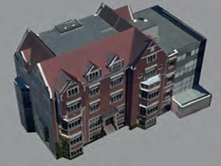
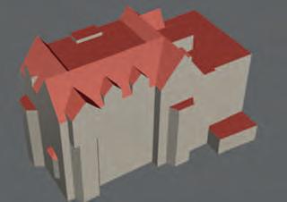
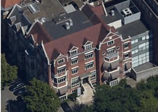
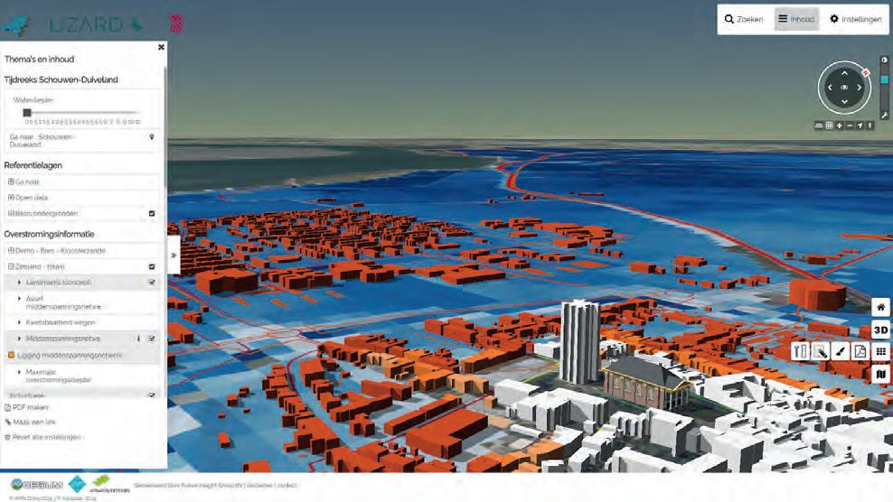
The company Avineon creates a state-of-the-art 3D city model with a level of detail LOD2.3, with a z-accuracy of 10cm and flawless alignment with the 2D large-scale base map.
The City of Groningen in the Netherlands is committed to working in 3D whenever possible; in fact, its motto is ‘We work in 3D unless...’. The municipality’s City Engineers, City Design and Geo & Data departments are currently working together to develop a digital 3D model of Groningen, both above and below ground. Stakeholders regard this ‘3D Digital City’ project as a next step to optimize the entire construction chain, since the 3D model will enable spatial projects to be carried out faster, more cost effectively and more transparently.
the imPortance of collaboration
In November 2019, the impressive Groninger Forum building opened in the city centre, serving as a meeting place and hub for inhabitants, students, government, business and cultural organizations. This building embodies the municipality’s focus on collaboration. The importance of cooperation between spatial departments in the spatial planning and development process also became clearly apparent during the construction of the Groninger Forum and other projects to renew the city centre. The municipality embraced the principles of Building Information Management (BIM) used in several construction processes and prepared a vision document on 3D. This vision corresponded completely with the coalition agreement document of the municipality.
Pilot Projects
In 2019, Groningen successfully conducted two pilot projects. The first was a pilot project of the 3D underground of the former sugar factory complex called ‘Suikerunieterrein’. The largely vacant site is to be redesigned, but there are objects in the subsoil that must be taken into account during the design. These were visualized in a 3D web map. The second pilot project was to build a 3D digital twin of the village of Ten Post, which is a few miles outside the city of Groningen, that the municipality could use for citizen participation, communication, planning and policymaking. Thanks to the success of these two pilot projects, the tender process for executing the 3D Digital City project as intended in the vision document was given the green light.
One company that got on board with the project at that point was Future Insight, which has been focused on 3D digital cities since 2014, for the City of Rotterdam. It is currently involved in numerous 3D digital twin projects worldwide based on the combination of 3D city models with, for example, sensor information, simulations and BIM designs. This makes a digital twin widely applicable for authorities to use in the different phases of a project, from planning and communication to completion.
Future Insight’s most important principle regarding a 3D digital twin is the use of open standards and technologies like CityGML and IFC as the basis for the solutions. This ensures that the solutions are flexible and scalable and can easily be reproduced by other customers or countries, while also offering the opportunity to connect with the newest open technologies that are available worldwide.
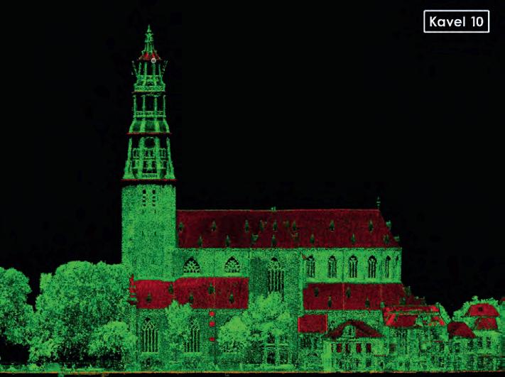
For the 3D Digital City project in Groningen, Future Insight’s role is the storage of 3D city data and making it easily available online. But first, accurate 3D data is needed. Kavel 10 – a company with a lot of international experience in collecting high-quality aerial imagery and Lidar point cloud data on a large scale – handled the 3D data collection aspect. The city of Groningen was flown with a 2.5cm GSD for the images and approximately 400 points per square metre with an overlap of 80/80%. The biggest advantage of this approach is the possibility for multiple use of the data that is acquired in one flight.
3D citY moDel
Based on the resulting high-quality datasets, the company Avineon is creating a state-ofthe-art 3D city model with a level of detail LOD2.3 (realistic roof modelling, taking into account dormers and roof overhangs, for buildings), with a z-accuracy of 10cm and flawless alignment with the 2D largescale base map. Moreover, Avineon will add textures to the buildings, using its innovative, and largely automated, 3D modelling process which chains multiple tools together in a smart way. Avineon has developed this semiautomatic 3D modelling process based on many years of experience acquired working with customers such as Rotterdam, Brussels, Geneva, Bern and Neuchâtel.
Besides the buildings, Avineon will also model other attributes from the 2D base map, such as bridges, walls, steps and trees, to make the 3D Digital City representation even more true to life.
conVenient anD aPPealinG
Lastly, all of this 3D information will be made available to the users, and it is important that this is done in a convenient and appealing way. First, the data will be stored in an open 3D CityGML database and the different layers will be published into open 3D Tiles services. This will make it easy to use the 3D data in multiple online tools without it having to be converted or distributed. As a result, all tools will automatically have up-to-date 3D data available directly from the source at the municipality of Groningen. Additionally, a download service will be made available, enabling everyone to download parts of the model to use in their own modelling tools such as SketchUp or Autocad.
The collaboration between the 3D specialists is enabling the requirements set by the City of Groningen to be met efficiently, and the municipality is taking an important and highquality step closer to meeting its 3D digital ambitions. Groningen values cooperation highly, and this partnership between experts and the city is another example of how Groningen wants to work together to meet its innovative goals.
The development of the 3D Digital City will help Groningen to become a smart city, not only by optimizing communication with the inhabitants of the city and other stakeholders, but also by supporting faster and better decision-making. Above all, a better understanding of the design stage of the construction process will help to prevent failure costs in the realization phase. The 3D model that is now being developed will provide the foundation for ensuring that spatial projects can be carried out faster, more cost effectively and more transparently.
about the authors
rick Klooster is cco of Future insight and project manager of the 3d Groningen project with years of experience in similar projects. He was one of the initiators of the dutch 3d pilot that resulted in a national 3d standard based on cityGml. He is the initiator of nederlandin3d.nl, where the collaboration with Kavel 10 and avineon originated. rick@futureinsight.nl
Gerben Gort is a technical specialist at Kavel 10 and the data collection specialist for the 3d Groningen project. He has been involved in a large number of domestic and international data collection projects, including collecting a full 3d model of london (UK). gerben@kavel10.nl
Paul van alphen is a technical specialist at avineon and the specialist in the 3d Groningen project responsible for processing the data into 3d models. He has worked on numerous projects, including the 3d project at the municipality of rotterdam. pvanslphen@avineon.com
marcel Klaveringa is head of the department for Spatial design & operations, Urban development at the municipality Groningen and contractor for the 3d Groningen project. He has years of experience as team lead within the field of urban development for the municipality and for different engineering companies. marcel.klaveringa@groningen.nl
FIG Commission 7: AGM 2020 Wrap-up
The 2020 FIG Commission 7 Annual General Meeting (AGM) has wrapped up! Over the course of three days, which were based around the joint themes of ‘Building community resilience through urban-rural land linkages’ and ‘Strategies to deal with COVID-19’, 200 registered participants attended 11 parallel sessions, with upwards of 50 expert presenters, across three major time zones. The initial positive feedback shows that the Commission is continuing to deliver on its 2018-2022 workplan despite the disruption during the COVID-19 period.
The 2020 AGM was certainly different to previous years. Fully online, it enabled participants to join from anywhere, at any time, at much-reduced financial and carbon costs. This resulted in a larger than usual attendance, meaning even more engagement with the Commission’s key activities. The event was multi-lingual, including dedicated French, Spanish and Mandarin sessions, enabling a more inclusive discourse. In addition, all profits from the event have been donated to the FIG Foundation.
ConCerns, Consensus, Community
The meeting kicked off with the Asia-Pacific Opening (Session 1), with Keith Bell, Kees de Zeeuw, Eva-Maria Unger, Michael Barry and Kate Rickersey giving their views on the current state of play and future directions for the global land administration sector. Concerns were raised about future land administration initiatives; donor restructures and that redirected funds will have an impact. Consensus-building activities – such as the recently endorsed UN-GGIM ‘Framework for Effective Land Administration’ (FELA) and the mindset for integrated community-led development – provide pathways forward.
eduCation at distanCe
Session 2, moderated by Commission 2 Chair David Mitchell, saw Chetna Ben, Dimo Todorovski and Kelly Lickley discuss the challenges and opportunities for surveying and spatial education brought about by the pandemic. The rapid transition to ‘fully online’ enabled continuity of training programmes and even increased engagement. However, challenges around delivering practical classes and matching face-to-face student experience were acknowledged.
integration, impaCts and introspeCtion
Session 3, the European Opening, saw FIG President Rudolf Staiger, Commission 7 Chair Daniel Paez, Danilo Antonio (GLTN) and Uchendu Eugene Chigbu discuss directly on both themes of the AGM. The key to urban and rural linkage is better policy, legal, technical and professional integration. Meanwhile, an introspective study of the impacts of COVID-19 on the surveyor profession showed, contrary to standard thinking, that over 30% of the community had actually experienced an increase in business and work – whether due to government stimulus or that fact that many land agencies are already fully digitally transformed.

progress, performanCe, prindex
Sessions 4, 5, and 6 were conducted fully in French, Spanish and Mandarin, respectively. The French session, led by former Commission 7 Chair Daniel Roberge, saw Claire Galpin, Rafic Khouri and JeanPhilippe Lestang detail the growing support and expansion of land administration implementations in both Francophone and non-Francophone countries. The Spanish session saw Ivonne Moreno, Juan Daniel Oveido, Mika Mora, Malcolm Childress and Stephane Palicot outline the really significant land sector progress happening in contexts like Colombia, and also the scaling up of the increasingly focused upon PRIndex land tenure security index. The Mandarin session, with inputs from Dong Jiang, Changgen Zhan, Liang Huang, Huanle He and UngYong Park, touched upon themes of cadastral data unification, codification and combinations of data sources.
disruption, improvement, value
Session 7 included a keynote from Rafael Tuts (UN-Habitat), alongside a presentation from Vladimire Evtimov (FAO), both focused on
the importance of cross-agency collaboration when it comes to urban-rural linkages, especially in these disrupted times. Kim Taikjin and Simon Jeon (LX) provided the innovations from South Korea, whilst James Kavanagh and former FIG President Chryssy Potsiou updated attendees on initiatives around unregistered land valuation and work from UN-ECE.
neCessity Before ideology
In Session 8, Kirsikka Riekkinen led a debate discussion on the roles of PPPs in the land sector, with inputs and examples from Peter Creuzer and Della R. Abdullah. Opportunities and cautionary examples were explored, with a key message being that PPPs should be driven by necessity in terms of fi nance and skills, not by ideology.
ready to sCale!
Session 9 illustrated how many land administration innovations developed over the last decades, including LADM II, FFPLA and the participatory toolsets of Cadasta and Meridia, have reached new levels of maturity and are scaling in terms of county-level uptake. Here, Christiaan Lemmen, Eftychia Kalogianna, Frank Pichel, Amy Coughenour, Paula Dijkstra and Simon Ulvund shared stories.
Convergent innovation inspires
Session 10 looked at more leading-edge technology developments relating to 3D cadastre, digital twins and artifi cial intelligence (AI). Peter van Oosterom, Mila Koeva, Brent Jones and Abbas Rajabifard delivered insights into the latest trends, also showing how many of the new developments are converging on different platforms and encouraging more engagement with other sectors.
Country reports and Close-out
The fi nal session was opened up to all participants, enabling freer interaction and the use of breakout groups. Country updates from Australia, the Netherlands, Russia, Indonesia, Croatia, Japan, Turkey and Portugal were delivered. The meeting concluded that the COVID-19 period has already changed the global land administration sector and is likely to increase tenure insecurity, rather than improve it. However, the situation also creates opportunities, and so it’s more important than ever to continue to come together, share the local lessons at the global level and keep strength within the FIG Commission 7 community.

Big tHanKs!
A big thanks to all the session moderators and rapporteurs, including Kwabena Asiama (YSN Chair), David Mitchell (Commission 2 Chair), Chethna Ben, Jean Pierre Habiyaremye, Daniel Roberge (Former Commission 7 Chair), Michel Morneau, Ivonne Moreno (The World Bank), Huayi Wu, Yue Ying, Mohsen Kalantari, Sylion Muramira, Kirsikka Riekkinen, Mila Koeva, Charles Atakora, Christiaan Lemmen, Rohan Bennett and Daniel Paez, and of course the FIG Offi ce – in particular Louise Friis-Hansen and Claudia Stormoen Pedersen – for making the online event possible.


Satellite Imagery: An Aerial Alternative
Remote sensing projects often begin with a question: Should I use aerial imagery or satellite imagery? This question may reoccur throughout long-term projects, particularly when unforeseen circumstances change the ability to collect data, the reliability of the data or the scope of the work. Budgets, technology and government restrictions are under constant transformation, making it critical to choose the right data inputs. There are a number of key parameters that must be taken into account when beginning any remote sensing project. These include the size and accessibility of the area of interest, the timeliness of the data, whether the data can be sourced from existing imagery or if a new collection is required, and – perhaps the most important aspect – the project budget.
EfficiEncy and scalE
Satellites can complete remote sensing projects more efficiently than aircraft, resulting in enormous impacts on cost-benefit analysis. The key difference is the speed and ease with which satellites can collect thousands of square kilometres in minutes without the complicated logistics of aircraft flight planning. Aircraft face greater restrictions; they must obtain airspace permits, plan for suitable take-off and landing points and adhere to ever-changing border and travel restrictions. Aircraft are also vulnerable to weather conditions such as heavy winds. Satellites simply don’t have any of these issues. They can collect isolated, conflicted or cross-border locations with ease. This applies particularly for large-scale mapping projects that may require multiple flights for manned or unmanned aircraft. These savings are significantly important in budget/timesensitive government mapping projects.
Tasking and procEssing
The planning of satellite tasking is fully customizable. This allows users to prioritize their areas for collection, define the resolution and spectral bands as well as specify collection angles. There is added flexibility for complex projects to adjust these requirements shortly before the acquisition takes place. Real-time weather updates ensure that the data acquisition will be as cloud-free as possible, further narrowing the competitive gap between aerial data and satellite imagery. After collection, satellite Imagery is directly downloaded through a ground station where it can be delivered to the user within hours of collection. Users may choose from several processing options and delivery methods.
collEcTion capabiliTiEs
Satellite imagery providers can collect data in various multispectral band combinations as well as stereo imagery in a single pass, eliminating the need for multiple flights by multiple specialized aircraft. Stereo imagery offers reliable data for the creation of digital elevation models (DEMs) and virtual 3D reconstructions. The suitability of 30cm satellite imagery for aerial imaging applications is confirmed by the National Imagery Interpretability Rating Scale (NIIRS), which is used by the imaging community to define and measure the quality of images and performance of imaging systems. Imagery captured in 30cm from Maxar’s WorldView-3 has a rating of NIIRS 5.7. This
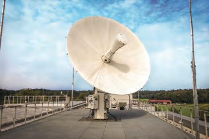
Figure 2: European Space Imaging’s ground station located at the German Aerospace Center (DLR).
means that it is possible to identify objects such as above-ground utility lines in a residential neighbourhood, impervious surfaces, crop species and their boundaries, vehicle types, manhole covers and much more.
pErmanEnT focus
Satellites can reach areas of interest that are difficult or inaccessible by other means and offer predictable and frequent refresh schedules. With high-frequency refresh rates, users can confidently request the exact same area of interest to be collected at specific intervals. This is a crucial feature for automated analysis. As with aerial data, satellite imagery can also be integrated into programmes using artificial intelligence to automatically extract and classify features and thereby streamline workflows. The amount of imagery collected over time by satellites compared to aerial solutions offers increased training data for machine learning applications. Additionally, users can take advantage of this historical data to model predictive analytics that are incredibly useful for trend analysis, anomaly detection at a mass scale and profitability estimates.
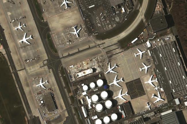
Figure 1: Frankfurt Airport captured with WorldView-3 while borders were closed during the coronavirus pandemic.
About the Author
skye boag is the marketing manager at european Space imaging. Holding a degree in marketing and public relations from deakin University australia, she has almost ten years’ experience within marketing and events across a wide range of industries. at european Space imaging she directs the brand, events and communication strategies across the business. Sboag@euspaceimaging.com