
Volume: 11 Issue: 07 | July 2024 www.irjet.net p-ISSN: 2395-0072

Volume: 11 Issue: 07 | July 2024 www.irjet.net p-ISSN: 2395-0072
Kiran
1 Suhas R: Student, Dept. of ECE, BNM Institute of Technology, Karnataka, India
2Prajwal S: Student, Dept. of ECE, BNM Institute of Technology, Karnataka, India
3Vimalesh J: Student, Dept. of ECE, BNM Institute of Technology, Karnataka, India
4Mr. Kiran K.N: Assistant Professor, Dept. of ECE, BNM Institute of Technology, Karnataka, India
5Sarala T, Assistant Professor, Dept. of ECE, BNM Institute of Technology, Karnataka, India.
Abstract – The tracking of vehicles is a very important aspect in many areas of traffic management. The GSM modem acts as the interface of the control room and is used to receive messages from the user. The received message is transmitted to the microcontroller and is also displayed on the electronic card equipped with the microcontroller. The Global Positioning System (GPS) is one among the satellites orbiting the earth. It sends back to earth details of their location in space. GPS has many uses as in the military field, weather conditions monitoring, vehicle positioning, agriculture, surveillance, and many other areas. Geofencing is a locationbased service that allows marketers to send messages to smartphone users who fall within a predefined geographic area. In geofencing, a combination of technologies, including GPS, area-providing satellite navigationsystem,is madeuseto create a virtual boundary around a business location. In this work carried out we aim to provide for Vehicle Location Tracking system using GSM along with, GPS and Geofencing techniques
Anovelsystemforvehiclelocationisproposedthatusinga aggregation of GPS, GSM and geofencing technology. This promisestorevolutionizereal-timetrackingandmonitoring at any location. The GPS module serves as a basis and ensuresthecorrectnessofobtainingthecorrectlocation.To achievethis,theGSMmoduleprovidesconnectivityatany locationbysimplyconnectingthe data sourceto a central server. Integrating these components is a microcontroller that acts as a workstation, controlling data flow and performing complex geofencing algorithms. A comprehensive system is designed that includes the GPS alongwiththeGSMmodules,followedbycentralserverfor the purpose of data storage and using an intelligent geofencingalgorithm.Thismakesitrobustandabletomeet the requirements of modern monitoring applications. The site tracking site promises to be efficient and secure, improvingfleetperformancewithreal-timevehicletracking, protecting valuable assets and ensuring the well-being of peopleinremoteordangerousareas.Thislocationtracking system incorporates advanced technology for providing a powerful,scalable,andefficientsystemforinstanttracking
andmonitoring.ByleveragingthepowerofGPS,GSMand geofencing,thesystemunlockstheopportunityforefficient, secure, and situational awareness for a wide range of applicationsinaconnectedworld.
The objective for developing location tracking using GSM togetherwithGPSandGeofencingtechniques istoallowfor fast tracking in transportation and logistics that allows shipments to be monitored, optimized and delivery times faster.Integrationofgeofencingaddsanadditionallayerof functionalitythatenablesautomaticresponsewhenadevice entersorleavesadefinedvirtualarea.Thisfeatureiscrucial inparentalcontrolapplications,fleetmanagementtogether with security procedures and provides instant alerts of deviations from the plan. The proposed work aims to developalgorithmsandmethodsthatwillensureanincrease thecorrectnessoflocationinformationreceivedfromGPS togetherwithGSMsignals,especiallyindifficultsituations. This work also aims to effectively leverage real-time data processing technologies to minimize delays in receiving, processing,andtransmittingdatasources.
In the “Intelligent monitoring of wireless environment throughcollection oftimeandanalytics, bySatoko Itayaa, Fumiko Ohoria, Toru Osugaa, Takeshi Matsumuraa”, the authours have proposed and developed an environment monitoringsystem for real-timecollection and analysisof wireless signals to monitor complex indoor wireless environments.Thesystemusescommercialhardwareand open-source software platforms suitable for continuous collaborationandopencollaboration.
The research related to the applications of GPS-based wirelesscommunicationsysteminhighwayandslideZiwen Xiong Xiong J. The research indicates that the wireless communicationnetworkGPSmulti-systemantennatracking is very beneficial in terms of response time. Based on the work executed, the authors are of the opinion that the wireless communication network GPS multi-antenna trackingsystemismoreaccurateandhasonlysmallerrors. [1] International Research Journal of Engineering and Technology (IRJET) e-ISSN: 2395-0056
International Research Journal of Engineering and Technology (IRJET) e-ISSN: 2395-0056
Volume: 11 Issue: 07 | July 2024 www.irjet.net p-ISSN: 2395-0072
Althoughthereliabilityoftheapplicationexamplehasbeen verified, the test case scenarios are not good enough to demonstrate the system’s applicability in difficult areas. Moretestinganddevelopmentareneededinthefuture.This paper also developed a time series model to estimate and verifythereliabilityofthemodelthroughexperiments.The evidence of the examples in the Limitations of location tracking in transmission article and considering the legitimacyandcostsoflandsecuritymonitoring,thearticle haspublishedaGPSmulti-antennamonitorreviewbasedon wirelesscommunication[2]
As per “The Frontiers of Space Travel” by Jay Stanley and Jennifer Stisa Granick. Global Positioning System. When phones turn on satellite detection, they can detect their locationwithanaccuracyof1meteratbest,butgenerallyat depths of 5 to 20 meters outdoors. GPS radio signals are weak;Theequipmentisnotusedindoorsanddoesnotwork satisfactorilynearlargebuildings,inlargecities,andduring storms,typhoonsandothersevereweatherconditions.
Assoonasthe GPS receiver is initially turnedonortaken outside, it may take a few seconds to identify its location. Additionally, cell phones receive transmissions from GPS satellites but do not automatically calculate, store, or transmit GPS location information. April 8, 2020[3]. The Research on the application of GPS-based wireless communication system in highway landslides is done [4]
The Global Positioning System Wide Area Augmentation System(WAAS)PerformanceStandardisproposed[5].The workingofGPSisanalyzedindetail[6].ThereleaseofGPSto public from military is provided[7]. The advanced GPS control is presented [8]. The accuracy of GPS to 1 foot is discussed [9]. The GAM and its long-range capability are discussedin[10,11]
This is a flowchart of a program that determines whether pointisinsideapolygon
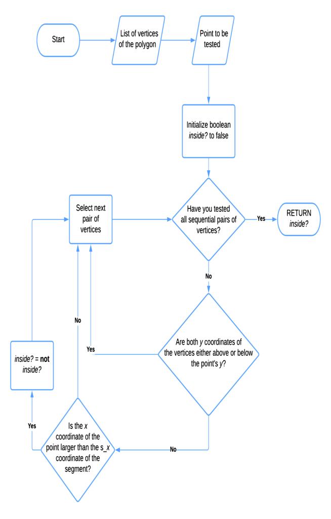
Fig -1:GeofencingFlowchart
Theprogramfirstlistsalltheverticesofthepolygonandthe pointswewanttotest.IttheninitializestheBooleanvariable called ? wrong. The program then selects the next pair of verticesinthepolygon.Itthencheckswhetherwehavetried all pairs in a row. If so, the program returns the value of internal ? If we have not tried all vertices in a row, the programcheckswhethertheycoordinateofpresentvertex pairishigherorlowercomparedtotheycoordinateofthe vertexpairwetried.Ifso,whatabouttheprograminstalled init?Negationoftheinside?
The programthencheckswhetherthex coordinateof the pointwearetestingisgreaterthanthexcoordinateofthe startingvertexofthecurrentsegment.Ifso,whataboutthe programsetting?Inanegativeway?Whentheprogramtests all connected vertical lines in the polygon, it returns the valueofinterior?Isitinside?Iftrue,thepointisinsidethe polygon.Isitinside?Iffalse,thepointisoutsidethepolygon.
Volume: 11 Issue: 07 | July 2024 www.irjet.net p-ISSN: 2395-0072
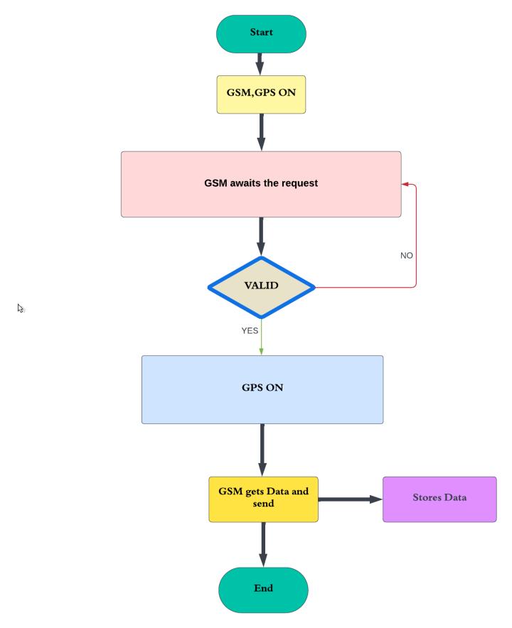
Fig -2:GSM,GPSFlowchart
ThisguidefirstchecksifGSMalongwithGPSareenabled.In this case, the system waits for the user's request. The requestcouldbeforcarparts,lockingtheengine,adjusting thespeedorchangingthenumber.Iftherequestisvalid,the systemturnsontheGPS.Itfurthersendstherequesttothe specific vehicle. The vehicle then moves, stops, or accelerates.GSMthenretrievestherequireddatafromthe vehicleproceedingtosavethedata ona SDcard. Theend user can access the data on the SD card. Below is a more detaileddescriptionofeachstepintheflowchart:
1.GSM,GPSenabled
ThesystemfirstcheckswhetherGSMandGPSareenabled. Otherwise,thesystemcannottrackthevehicle.
2.GSMStandbyRequest
GSMStandbyrequestfromusers.Therequestcouldbefor carparts,lockingtheengine,adjustingthespeedorchanging thenumber.
3.(Location/EngineStop/SpeedLimit/NumberChange)
This is the request sent by the user to GSM. The request couldbeforcarparts,lockingtheengine,adjustingthespeed orchangingthenumber.
4.No
Iftherequestisinvalid,thesystemproceedstostep1.
5.Yes
Iftherequestisvalid,thesystemproceedstostep6.
6.GPSON(SendRequest)
The system turns on the GPS and sends a request to the vehicle.Thevehiclethenmoves,stopsoraccelerates.
7.GSMreceivesandsendsdata
GSMreceivesdatafromthevehicleandforwardsthedatato theSDcard.
8.StoreonSDCard
GSMstoresthedataonthevehicleintheSDcard.
9.EndUser
TheendusercanaccessthedataontheSDcard.
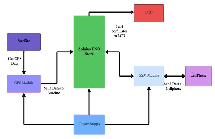
Cellphonesworkprimarilybyreceivingthesignalfromthe cellphone.ThesignalisthendecodedbytheArduinoUNO board.TheArduinoUNOboardwillsendtheoutputsignalto the appropriate device such as LCD, GPS module or GSM module. Mobile phones can also send signals to mobile phones.Forexample,whenausercalls,thephonesendsa signal to the mobile phone to initiate the call. The block diagramshowshowthedifferentcomponentsofthephone worktomakecalls.Cellphonesmayalsobeusedtosendand receivetextmessages.Sendingandreceivingatextmessage islikemakingaphonecall.
Theblockdiagramalsoshowsthatamobilephonemaybe usedtotrack a user'slocation.TheGPS moduleisused to tracktheuser'slocation.TheGPSmodulesendstheuser's locationcoordinatestotheArduinoUNOboard.TheArduino International Research Journal of Engineering and Technology (IRJET) e-ISSN: 2395-0056
Volume: 11 Issue: 07 | July 2024 www.irjet.net p-ISSN: 2395-0072
UNOboardwillfurthersendtheuserinterfacetotheGSM module. The GSM module then sends the user's location checktothemobilephone.Cellphonecamerascantrackthe user's location. A mobile phone is a complex device, but a block diagram shows how the different parts of a mobile phoneworktogethertomakeitwork.
Theimplementationoutlinesagenericapproachtocreating alocationtrackingsystemusingGPS,GSM,andgeofencing technologies,withtheArduinoUNOservingasthecentral control unit. The system is comprised of three main components: the GPS module, the GSM module, and the microcontroller (Arduino UNO). The GPS module continuously retrieves the device's current latitude and longitude coordinates. These coordinates are further processed by the Arduino UNO, which can trigger actions basedonpredefinedconditions,suchasenteringorexitinga geofencedarea.
The GSM module enables communication with remote devices or servers. In this implementation, it is utilized to send SMS alerts when the device enters or exits the predefinedgeofencedareaasshowninFig4
The system operates within a loop, where it continuously readsdatafromtheGPSandGSMmodules.WhenGPSdatais received, it is processed to find out the device's current location. This location data is then compared with predefinedgeofencecoordinatestodetectifthedevicehas crossed the boundary of the geofenced area. If the device entersorexitsthegeofencedarea,atriggerisactivatedto sendanSMSalertviatheGSMmodule.
Overall,thissystemprovidesaflexibleplatformfortracking the location of a device and implementing geofencing functionality, which may be applied in various scenarios such as vehicle tracking, asset management, or personal safety applications. The modular based design allows for customization and scalability to meet specific project requirements.
A GSM, GPS and geofencing tracking system combines the functionalities of GSM (Global System for Mobile Communication) and GPS (Global Positioning System) technologiestotrackandmonitorthelocationofassets,such asvehiclesorindividuals.
1.GPSLocationData:TheprimaryoutputofaGPStracking systemisthelocationdataobtainedfromtheGPSmodule. Thisdataincludeslatitudeandlongitudecoordinates,which represent the precise geographic location of the tracked assetatanygiventime.
2. Timestamp: Along with the location data, GPS tracking systems often provide a timestamp indicating the time of locationrecording Thisallowsuserstotrackthemovement of the asset over time and determine its historical whereabouts
3. Speed and Direction: Some GPS tracking systems also providefurtherinformationsuchviz.speedanddirectionof thetrackedasset.Thisdataisusefulformonitoringvehicle speedcomplianceoranalyzingtravelpatterns
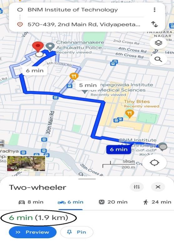
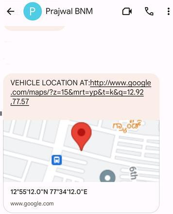
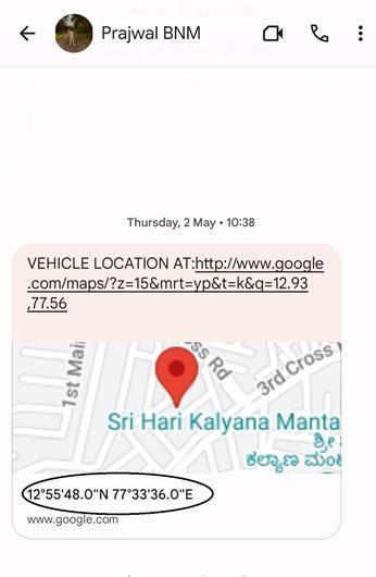
Fig8showsatextmessagewithalocationembeddedinit.It containsastaticmap.Thefollowingisaexplanationofhow theGSMnetworkfacilitatesthesendingofanSMSmessage toacellularphone:
1. User Initiates SMS: The process begins when a user decides to send SMS message from their device. They typically compose the message using the messaging applicationontheirphone.
2.MessageRouting:Oncetheuserhitssend,themessageis processedbytheirmobiledevice.Thedevicecommunicates withthenearestBaseTransceiverStation(BTS),partofthe BaseStationSubsystem(BSS)
3.BTSCommunication:TheBTSreceivesthemessagefrom the mobile device and forwards the message to the Base StationController(BSC),whichisresponsibleformanaging multipleBTSswithinitscoveragearea.
4.NetworkHandoff:TheBSCthenroutesthemessagetothe MobileSwitchingCenter(MSC),whichispartoftheNetwork Switching Subsystem (NSS). The MSC is responsible for switchingandroutingvoiceanddatacallswithintheGSM network.
5.MessageDelivery:Atthispoint,theMSCdeterminesthe recipient'slocationbasedontheirmobilephonenumber.If therecipientiswithinthesameGSMnetwork,themessageis then routed directly to the MSC serving their current location.
6. Interconnection (If needed): If the recipient is on a differentGSMnetworkorlocatedoutsidethehomenetwork coveragearea,theMSCmayneedtocommunicatewithother MSCsorexternalnetworkstoreachtherecipient'sdevice.
7.MessageDeliverytoRecipient:Oncethemessagereaches theMSCservingtherecipient'slocation,itisdeliveredtothe recipient'smobiledevice.Thedevicereceivesthemessage andnotifiestheuserofthenewSMS.
8. Acknowledgment: The recipient's device sends an acknowledgment message back to the sender's device, confirmingthattheSMSwassuccessfullyreceived.
9.UserInteraction:Therecipientcanthenviewthereceived SMSmessageontheirdeviceandchoosetoread,reply,or ignoreitasdesired.
Throughout this process, the GSM network ensures the reliable and timely delivery of the SMS message from the sendertotherecipient'scellularphone,regardlessoftheir locationwithinthenetworkcoveragearea.
International Research Journal of Engineering and Technology (IRJET) e-ISSN: 2395-0056
Volume: 11 Issue: 07 | July 2024 www.irjet.net p-ISSN: 2395-0072
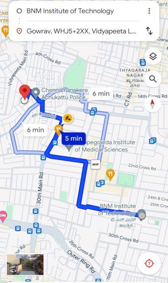
Fig -9:RealTimeVehicleLocationusingMaps
Fig 9 map centers on BNM Institute of Technology. Text labels on the map around BNM Institute of Technology include“Gowrav,WHJ5+2XX,Vidyapeeta”Themapdisplays thedistancetothedestinationfromyourcurrentlocation, butthedestinationitselfisnotshowninthescreenshot.In thebottomleftcorneroftheimage,itshows“6min”nextto “ChennamanakereRd”whichlikelyindicatesthedistanceto ChennamanakereRdalongtheroute
In summary, the integration of GSM, GPS and geofencing technology into the location tracking system provides a solution for monitoring and controlling the instantaneous location of the equipment. While GPS modules provide accuratelocationmanagement,GSMmoduleshelptransmit this information to a central server or database. A microcontrollerisincludedforefficientoperationanddata flowcontrol.
The utilization of geofencing algorithms allows creating virtual boundaries and triggering events when the device enters or leaves these areas. While central servers play a significantroleinreceiving,storing,andprocessinglocation data, the selected communication system also ensures efficient and secure transmission. To improve user experience,userinterfacescanbedesignedtodisplayand specifygoals.Emphasizethatpowermanagementiscritical to extending the battery life of devices and that security measuresmustbetakentoprotectsensitivelocationdata. The system's scalability, error handling mechanisms, and regulatory compliance further enhance its robustness. Essentially, the integrated system uses a combination of GSM, GPS and geofencing technology to provide for a versatileandeffectivesolutionfora rangeofapplications, fromassettrackingtopersonalsecurity.
[1]Intelligentmonitoringofwirelessenvironmentthrough collection of time and analytics by Satoko Itayaa, Fumiko Ohoria, Toru Osugaa, Takeshi Matsumuraa. The 14th International Conference on Environmental Systems, Networksand Technologies(ANT)will beheldinLeuven, Belgium,on15-17March2023.
[2]. LimitationsoflocationtrackingintransmissionBy:Jay StanleyandJenniferStisaGranickApril8,2020
[3].InternationalJournalofComputerScience,Engineering and Applications (IJCSEA), Pankaj Verma 1, J.S Bhatia 2. Vol.3, No.3, June 2013 DOI: 10.5121/ijcsea.2013.3304 33 GoogledesignandGrowthbasedonGPS-gsmGoogledesign system-basedevaluation.
[4] Research on the application of GPS-based wireless communication system in highway landslides Zhiwen Xiongxiong J Wireless Communications Network (2021) 2021:163
[5] "Global Positioning System Wide Area Augmentation System (WAAS) Performance Standard" (PDF). p. B-3. Archived (PDF) from the original on April 27, 2017. RetrievedJanuary3,2012.
[6]ScienceReferenceSection(November19,2019)."Whatis aGPS?Howdoesitwork?".EverydayMysteries.Libraryof Congress. Archived from the original on April 12, 2022. RetrievedApril12,2022.
[7] McDuffie, Juquai (June 19, 2017). "Why the Military Released GPS to the Public". Popular Mechanics. Archived fromtheoriginalonJanuary28,2020.RetrievedFebruary1, 2020.
[8] "Factsheets: GPS Advanced Control Segment (OCX)". Losangeles.af.mil. October 25, 2011. Archived from the originalonMay3,2012.RetrievedNovember6,2011.
[9]Kastrenakes,Jacob(September25,2017)."GPSwillbe accurate within one foot in some phones next year". The Verge. Archived from the original on January 18, 2018. RetrievedJanuary17,2018.
[10] "GSM (2nd Generation Mobiles)". Engaging with Communications.Archivedfromtheoriginalon30January 2023.Retrieved23May2023.
[11]MotorolaDemonstratesLongRangeGSMCapability –300%MoreCoveragewithNewExtendedCell.Archived19 February2012attheWaybackMachine.