
International Research Journal of Engineering and Technology (IRJET) e-ISSN: 2395-0056

International Research Journal of Engineering and Technology (IRJET) e-ISSN: 2395-0056
Sayan
Munshi1 , Devesh Mani Tripathi2 , Dr. Subhrajit Banerjee3 , Dr. Indrani Chakraborty4
1 Asst. Professor, ASAPK, Amity University, Kolkata, WB, India
2 Principal Arcitect/Urban Planner, ICON Architects, Lucknow, UP, India
3Professor, Faculty of Architecture and Planning, AKTU Lucknow, UP, India
4Professor, Faculty of Architecture and Planning, AKTU Lucknow, UP, India
Abstract - Canals serve as critical components of sustainable development, impacting various facets of urban life. While traditional research on canal irrigation has primarily focused on rural agriculture, the urbanizing effect on canals has been underexplored. Cities along canals show tremendous climatic variation such as impact of the urban heat islands, air pollution levels, humidity control, etc. This factor of canals showing character of a river in certain cities tend to attract a significant amount of population to settle alongthestretchwhichbringsabouttheeffectofurbanization whichtransforms/changesthelanduseandlandutilizationin turn results to over utilization in certain case. This paper examinestheKukrailCanalinLucknow,India,emphasizingits ecological significance and its role in maintaining local biodiversity.Furthermore,itexploresthetemporalchangesin land use patterns over two decades, highlighting the encroachmentofurbanareasintothecanalscatchmentarea. The study also investigates two best practices in canal restoration through case studies in Birmingham (UK), and Utrecht (Netherlands) showcasing successful approaches to canal revitalization. The paper concludes by proposing quantitative method of analysis of Land-use and canal development,emphasizingtheimportanceofbalancingurban development with ecological preservation to maximize the potential benefits of canals for urban communities.
Key Words: UrbanPlanning,CanalRestoration,WaterBody rejuvenation,Ecosystem,Environment
Watercanalsactasanenvironmentalregulatorandasource ofcarbontrapsinacity.Therearevarioustypeofcanalsina citywhichcanbeclassifiedbynatureofthesupplysource, functions,typeofboundarysurfacesoil,financialoutput,and dischargeandcanalalignment.(OSME,Keonjhar).Basedon thetypesofcanalsthespecificusageisobservedinvarious cities.Thisdefinedthetypeofsettlementswhichdevelops over time. The use of water to serve urban consumption throughdrinkingandwastewatercanalsisanimportantyet understudied aspect of urbanization in the cities of India. Thecanalsestablishaphysicalmanifestationoftheflowsof
Volume: 11 Issue: 07 | July 2024 www.irjet.net p-ISSN: 2395-0072 © 2024, IRJET | Impact Factor value: 8.226 | ISO 9001:2008 Certified Journal | Page1268
water between the rural and the urban. The mainstream literatureoncanalirrigationinIndiahastraditionallybeen rural-centered, and has been confined to only canals specificallybuilttoserveagriculture.Butascanalsactasa transitionbetweentheruralandurban,itisobservedthatin some cases these canals are subjected to the effect of urbanism such as use as a medium of discharge of liquid waste. The effect of urbanism on canals includes various factorslikechangestothenaturalhabitatoflocalfloraand fauna,biodiversityloss,degradationofecosystemprocesses, Introduction of various industrial discharges, polluted surfacewaterrunoff,etc.(SoumyadeepD,IJUP2020)
Urbanizationis linked to modernization,industrialization, andthesociologicalprocessofrationalization.Urbanization is not merely a modern phenomenon, but a rapid and historic transformation of human social roots on a global scale,wherebypredominantlyruralcultureisbeingrapidly replaced by predominantly urban culture. This change or transformationleadstoashiftinpracticesofutilizationof resource, which also includes the biological/Chemical compositionofthesurfacerunoff.Leadingtoalteration in the physical, chemical and biological properties of canals. India being a predominant society based on the agrarian based economy, a significant concentration of pesticide basedsurfacerunoffcanbetraced.Thisrunofffusionactsas amajorcontributorofwaterpollution.Inthisconjuncture thesecanalsflowintotheurbanareasandaresubjectedto further degradation. As cities in developing countries becomeover-populatedandover-crowdedpartlyasaresult oftheincreaseinpopulationoverthedecadesandpartlyasa resultofmigration.Indiasharesmostcharacteristicfeatures of urbanization, the most significant phenomenon of 20th centurywhichhasalmostaffectedallaspectsofnationallife. Thiscanbeestablishedwiththisfactthatland-usechange and canal degradation is closely linked. (Water Science School,2019).
Nowadays,itisobservedthatthemajorcitiesofIndiathat arelinkedcanalsarehighlypolluted,andadegradedlevelof COD (chemical oxygen demand) and BOD (biochemical oxygen demand) is observed. Cities with canals hold a
International Research Journal of Engineering and Technology (IRJET) e-ISSN: 2395-0056
Volume: 11 Issue: 07 | July 2024 www.irjet.net p-ISSN: 2395-0072
uniqueadvantage,asthesewaterwaysofferaperfectblend ofnaturalretreat,andculturalsignificance.Leveragingthis resourcecansignificantlyenhancetheirtourismpotentialby promoting a destination-based approach. Tourism Destination based approach includes creation of potential tourismsiteswhichholdsthepotentialtoattracttourism,as wellasactasaimagetothecitywhichiselaboratedfurther inthecasesdiscussesinthepaper.(Munshi,etal,2022).
Indiahashadvariouscanalrestorationprogramsaimedat revitalizingandpreservingitsextensivenetworkofcanals. Thesecanalsplayacrucialroleinthecountry’sagriculture, water supply, and overall socio-economic development. Some of the programs include Pradhan Mantri Krishi SinchayeeYojana(PMKSY),Launchedin2015,PMKSYisa flagship program of the Government of India aimed at providing a comprehensive solution to the problem of irrigation focuses on the restoration of traditional water bodies, including canals (Accounting to more than 3 lakh waterbodiesover70lakhhectares).AcceleratedIrrigation BenefitProgramme(AIBP),TheAIBP,initiatedin1996-97, aims to accelerate the process of irrigation in the country throughrestorationandcreationofirrigationinfrastructure, which includes canals. National Mission for Clean Ganga (NMCG), NMCG, also known as Namami Gange, is a comprehensive program for cleaning and conserving the GangaRiveranditstributaries,Italsoincludesinitiativesfor restoringandconservingtraditionalwaterbodieslikecanals thatfeedintotheGanga.Thisprogramincludedcreationof Morethan 150seweragetreatmentplantaccounting3,000 million liters per day (MLD). Integrated Watershed Management Program (IWMP), IWMP, launched in 2009, aims to restore and conserve natural resources including waterbodieslikerivers,lakes,andcanals.
Kerala”sRiverandCanalRestorationPrograms,beingastate with an intricate network of rivers and canals, has had various programs to restore and maintain these water bodies for irrigation and transportation. Andhra Pradesh CanalRestorationProjects,hasimplementedseveralcanal restoration projects to improve irrigation facilities and ensurewaterreachesthefarmlandsefficiently.GujaratCanal Rehabilitation and Modernization Project, This project focusesontherehabilitationandmodernizationofexisting canalsystemstoimprovetheirefficiencyandeffectivenessin delivering water for agricultural purposes. While non agriculture based Tourism project of canal rejuvenation includeRajasthanCanalRestorationProject,Thisprogram aimed at specific projects to restore and revitalize its extensivenetworkofcanalsincludingtheDravyavatiRiver FrontprojectinJaipurwithapproximately47.5kilometers length integrated with STPs of capacity 170 MLD (million litersperday).Thisprojectactsasasignificantsteptowards urban renewal andenvironmental sustainabilityin Jaipur, showcasingthepotentialofintegratedurbandevelopment
initiatives in transforming degraded urban spaces into vibrant, healthy, and sustainable environments creating tourismpotentialforthecity.
Fromtheabovecasesofagricultureandurbancanals,itis evidentthatcanalsactsasversatileurbanfeaturesthatserve multiple functions, contributing to the livability, sustainability, and economic vitality of cities. They have played a crucial role in the development and evolution of many urban areas throughout history. Historically, Canals are used to transport and distribute water within a city, including drinking water, industrial processes, and irrigation.Theycanhelpensureastableandreliablewater supply, especially in areas prone to water scarcity. Canals were critical for transportation and trade. They provided navigable routes for boats and ships, facilitating the movementofgoodsandpeoplewithinandbetweencities.In somecities,canalsarestillusedfortransportation,tourism, and recreational boating. (Xu R, AMR 2014). Canals are essential for managing excess rainwater and preventing flooding in urban areas. They serve as drainage channels, diverting excess water away from populated areas during heavyrainfallorstorms.Canalscanhaveamoderatingeffect onacity”sclimate.Theycanhelpregulatetemperatureand humiditylevels,creatingmorecomfortablelivingconditions inurbanareas.Canals,whenproperlymanaged,cansupport a diverse range of aquatic and riparian species. They contribute to local biodiversity and provide ecosystem services such as water filtration, habitat provision, and floodplain protection. Many cities have canals that hold culturalandhistoricalsignificance.Theymaybeassociated withthecity”sheritage,architecture,andtraditions.Some cities,like Veniceand Amsterdam, arerenownedfortheir extensivecanalnetworks.WiththisassociationCanalscould beasourceofinboundtourismcreation,byactingasafactor additive in the tourism potentiality, drawing visitors intending to experience boat tours, explore canal-side neighborhoods, and enjoy the unique ambiance. This can boostthelocaleconomythroughtourism-relatedactivities. This versatility of canals makes it a unique feature which enhanceanytypeoftourismi.e.Adventuretourism,Cultural tourism,Ecotourism,Medicaltourism,Wildlifetourism,etc. ThecaseofKukrailCanaliselaboratedinthefurthersection which establishes the degradation of canal to a drainage channelovertimeanditspotentialimpactoverthecity.
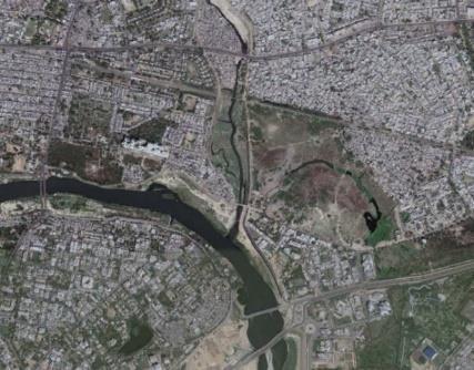
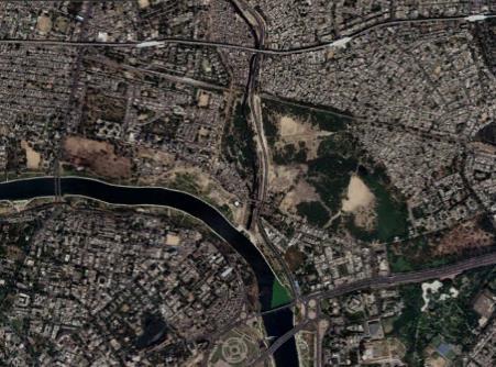
KukrailCanalor‘KukrailNala’(AspertheLocalName,the term‘Nala’meansdrainagechannel)isaleftbanktributary oftheRiverGomtiwhichformsthefourth-order(medium stream) tributary of the River. It is a groundwater-fed stream that rises in the Kukrail Reserved Forest (26°55'34.9"N80°59'47.3"E)andConfluenceatGomtiRiver
International Research Journal of Engineering and Technology (IRJET) e-ISSN: 2395-0056
Volume: 11 Issue: 07 | July 2024 www.irjet.net p-ISSN: 2395-0072
(26°51'35.4"N80°58'03.4"E).Ithasa200metrewideflood plain.TheKukrailnalaextendsforatotaldistanceofaround 26kilometresfromitssourcetothesiteofconfluence.Itisa natural drain of Gomti River and a carrier of partially untreatedsewageandwatertotheriver.KukrailNalaholds significant importance for the local ecosystem, acting as a crucial drainage system for the region. It helps prevent waterloggingandfloodinginnearbyareasduringperiodsof heavyrainfall.
One of the most notable features is the Kukrail Wildlife Sanctuary, which is located along banks of the Canal. The sanctuary was established in 1978 and covers an area of around 400 acres. It serves as a protected habitat for a varietyofwildlifespecies,includingcrocodiles,turtles,deer, and various bird species. The Wildlife Sanctuary offers opportunitiesforecotourismandwildlifeviewing.Visitors canexplorethesanctuarythroughguidedtoursandobserve thediversefloraandfaunaoftheregion.Beyonditsrolein wildlife conservation, Kukrail Nala and its associated sanctuary play a crucial role in maintaining the environmentalbalanceoftheregion.Ithelpsinregulating waterflow,preventingwaterpollution,andsupportinglocal biodiversity.
4.1 Temporal Change of Land-use and Land-cover in the Urban Core of Lucknow City
Temporal land use refers to the specific ways in which land is utilized or managed over time. It involves understanding how different activities and functions on a pieceoflandchangeorevolveacrossvariousperiods.This can include activities like agriculture, urban development, forestry, conservation efforts, and other forms of land management.
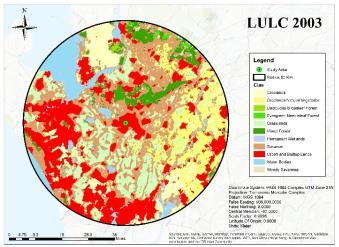
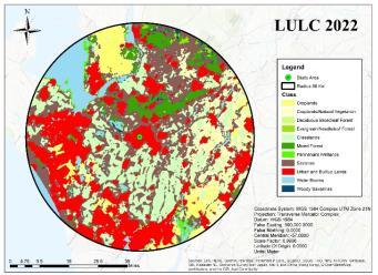
2003, 2013 and 2022 (Latest Available) is produced for Analysis in ARC GIS. An Model area of 50km Buffer is consideredasthestudyareabasedontheWatershedpoint fromKukrailCanalat26°51”35.3"N80°58”02.8"E.
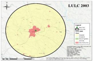
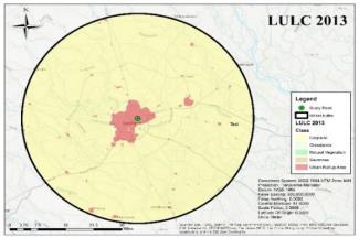
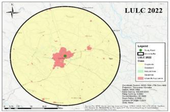
Fig -2:ARCGISbasedLULCAnalysisof50Kmbuffer (MODISMCD12Q2V6.1model)
AnalysisoftheFigure42ARCGISbasedLULCAnalysisof 50Km buffer (MODIS MCD12Q2 V6.1 model) temporal landuse change has been done using Gridcode from MCD12Q1InternationalGeosphere-BiosphereProgramme (IGBP)Legends.
Table -1: DecadalTemporalChangeofLucknowasper MODISMCD12Q2V6.1model(2003,2013,2022)
TheaboveFig-1,depictsthechangeoflandusepatternin theGomti-Kukrailmeargingpoint.Itcanbeobservedthatthe over the time the Catchment area of the canal has reduced/occupied by the urban builtup area and the surrounding area has densified. The densified area is a mixlanduse of residential area, Small Scale Industry and Enchroachedsettlement.Toanalysethetemporallandusea GIS based approach is used based on the Digital Elevation modelof“NASALPDAACCollection”theyearlyvariationsare producedthroughMODISMCD12Q2V6.1modelandModelof
* International Geosphere-Biosphere Programme (IGBP) Legends.
Savannas: TreeCover10%-30%(Canopy>2m)
Gasslands: Dominatedbyherbaceousannuls(<2m)
Croplands: Atleast60%ofareaiscultivatedcroplands
International Research Journal of Engineering and Technology (IRJET) e-ISSN: 2395-0056
Volume: 11 Issue: 07 | July 2024 www.irjet.net p-ISSN: 2395-0072
Urban and Builtup Lands: Atleast30%impervioussurface areaincludingbuildingmaterial,asphalt,vehicals.
Croplands/Natural Vegetation Mosaics: Mosaicsofsmall scale cultivation 40-60& with Natural Trees, Shurbs or Herbaceousvegetation.
Thetemporalchangeestablishesthefactthatalongwith increase in Urban Built up a significant effect on the Savannas,GrasslandsandCroplandisobservedthroughout two decades. For savannas it is observed in Table 1, that thereisanoverallincreaseinthesharewhencomparedto thebaseyearof2003,Grasslandsshowagradualincreasein share, Croplands shows a significant decrease in share, Urban and Built-up Lands shows a Significant increase in concentration,andCroplands/Natural Vegetationshowsa significantdecreaseinconcentration.
Theselectionofthecanalcitiesarebasedonthesimilarityin topographyasofthetargetcityofLucknow.
5.1
Birmingham, located in the West Midlands region of England,isknownforitsextensivecanalnetwork.Itplayeda significant role in the Industrial Revolution and has left a lasting legacy on the city”s landscape and culture. Birmingham’s canals were instrumental in the city’s industrialdevelopmentduringthelate18thandearly19th centuries.Theyprovidedameanstotransportrawmaterials andfinishedproductstoandfromfactoriesandworkshops. Thecanalsarelinedwithhistoricbuildings,warehouses,and factories, many of which have been preserved and repurposed for modern use. The architecture along the canalsreflectsthecity”sindustrialheritage.Birmingham”s canal network is of national historical and cultural importance. It”s recognized for its contribution to the industrialdevelopmentoftheUK.
Inrecentdecades,thecanalshaveundergonesignificant regenerationefforts.Theareaaroundthecanalshasbecome apopulardestinationforleisureactivities,includingwalking, cycling,andcanal boattrips.It”salsohometoa varietyof restaurants,shops,andculturalvenues.
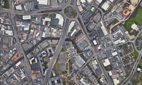
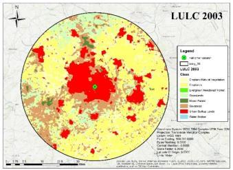
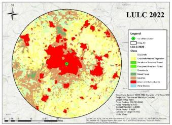
Table -2: DecadalTemporalChangeofBirminghamas perMODISMCD12Q2V6.1model(2003,2013,2022)
Volume: 11 Issue: 07 | July 2024 www.irjet.net
Thelanduse/landcover(LULC)datafrom2003to2022 revealsnotabletrendsacrossvariouslandclasses.Evergreen Broadleaf Forest showed minimal presence, with a slight increase in 2013 that remained stable through 2022. DeciduousBroadleafForestexperiencedamodestincrease from2003to2013,butthendecreasedbacktoitsoriginal areaby2022.MixedForestareassteadilyincreasedoverthe years, suggesting a gradual expansion. Savannas initially expandedbetween2003and2013butsawaslightdecline by2022.Grasslandsexperiencedasignificantdecreasefrom 2003to2013,followedbyasubstantialrecoveryby2022. Croplands consistently decreased over the entire period, indicatingareductioninagriculturalland.UrbanandBuiltupLandssawacontinuous,albeitsmall,increase,reflecting ongoingurbanization.Croplands/NaturalVegetationareas expanded significantly by 2013 but slightly decreased by 2022. Water Bodies remained unchanged throughout the period,maintainingaconstantarea.Thesechangesillustrate dynamic land use patterns influenced by natural and anthropogenicfactorsovertheyears.
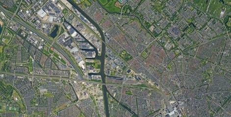
ThecanalsofUtrecht,locatedintheNetherlands,arean integral part of the city”s history and urban landscape. Utrechtisknownforitspicturesquecanals,whicharelined withhistoricbuildingsandvibrantstreets.Oneofthemost famous canals in Utrecht is the Oudegracht. It is unique because it has a wharf-level section, where you can find many restaurants, cafes, and shops built directly into the arches of the canal”s retaining walls. Parallel to the Oudegracht is the Nieuwegracht. It was built in the 14th centuryandisknownforitscharacteristicwharfsandcellar spaces,similartotheOudegracht.Alongthecanals,onecan find a wealth of historic buildings, including charming houses,churches,andwarehouses.Manyofthesestructures datebackcenturiesandcontributetothecity”sdistinctive atmosphere.
The canals provide an opportunity for recreational activitieslikeboatingandcanoeing.Therearerentalservices thatallowyoutoexplorethecityfromauniqueperspective. Thecanalsserveasvenuesforvariouseventsandfestivals throughouttheyear.Thesecanrangefromculturalfestivals tomarketsandevenboatraces.
The selection of the Energlhaven at the Vleutensespoorbrug at 52°05”55.1"N 5°04”37.1"E for the purpose of the study due to a high concentration of Transportation, commercial, Recreational and residential zone.
Croplands/Nat ural
International Research Journal of Engineering and Technology (IRJET) e-ISSN: 2395-0056
Volume: 11 Issue: 07 | July 2024 www.irjet.net p-ISSN: 2395-0072
The methodology of analysis is based on the ranking analysisbetweenfactorswhicharecommoninallthe4cases studied.
Table -3: AbsolutevalueofGrid-codeAreas(Databased onLULC-MODISMCD12Q2V6.12022)
Table -4: R&R2 Table
a.PredictorConstant:NaturalVegetation,Grasslands
b.DependentVariable–CanalofLength
TheResultbeing1showsapositiveindicationofrelation betweentheVariableasshowninTable63R&R2Table
Analysing coefficient is importan in a model as it provides valuable insights into model behaviour, enhances performance, and facilitates clearer communication and understanding of predictive models.
Table -5: CoefficientAnalysisTable
The following Table 3, reflects the weightage between common 5 factor (Savanas, Grasslands, Croplands, Urban andBuilt-upLandsandCroplands/NaturalVegetation).
Table -3: Weightageanalysisoutof100(Databasedon LULC-MODISMCD12Q2V6.12022)
Theprocessofmodelling numerous factors,ordependent variables,usingasinglesetofpredictorvariablesisknown as multivariate multiple regression. It regresses each dependentvariableonthepredictorsindependently.
i. Check for R and R2
The variance inflation factor (VIF) is a metric for determining how much multicollinearity there is in a collection of multivariate regression variables. If a VIF is greater than ten, substantial multicollinearity is present, accordingtoaruleofthumboftenemployedinpractice.The regression is in reasonable form in this case, with values around1asobservedinTable5.
An equation for Canal Length can be derived (Based on Standardizedcoefficient)assuch–
Canal Length (L) = 0.594 (Grasslands) - 1.152 (Natural_Vegetaton)……………..(i)
As per the analysis the observation form the generated EquationNo.(i),Theareaofthecanalinaregionwouldbe used to predict a ideal area under natural vegetation and grasslands in a region. Thus, to imply the equation over a studyregion:
Let,
International Research Journal of Engineering and Technology (IRJET) e-ISSN: 2395-0056
Volume: 11 Issue: 07 | July 2024 www.irjet.net p-ISSN: 2395-0072
Grasslandsbe“x”andNaturalVegetationbe“y”,
Sothattheequationcanbereinterpretedas L=0.594x-1.152y………………………..(ii)
Inthiscaseusinggraphicalinterceptsofxandy,wehaveto assumetheextremecaseswheretofindxintercept,ymust beequaltozeroandviceversa.
Usingthisinformationwere-interprettheconditionofstudy regioninLucknow,wheretheareaofcanalis0.0012000sq km.Byequatingthethederivedequation(ii),x-interceptis approximately=0.0020202, x=0.0020202,whichgivesthe point (0.00202, 0). Similarly, the y-intercept is approximately=−0.0010417y=−0.0010417,whichgivesthe point(0,−0.0010417)(0,−0.0010417).
Therefore, the solution to the equation is the intersection point of the x-intercept and y-intercept, which is approximately (0.0020202,0)(0.0020202,0) or (0,−0.0010417)(0,−0.0010417).
BasedonthefindingforthecaseofLucknow,
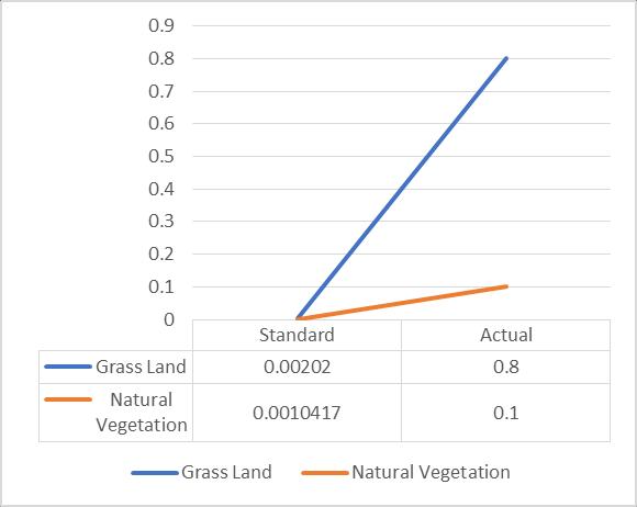
Chart -1:ObservationforDeviationinforthecaseof Lucknow
BasedonthefindingforthecaseofLucknow,
o Grasslands(x):0.00202sqkm
o NaturalVegetation(y):=(−0.0010417)~= 0.0010417sqkm(Absolutevalueforarea)
AnalysingtheDeviation,
ItisobservedformChart1,thatthestudyregionhasascore higherthanthebenchmark,thusnospecificinterventionis recommendedforthecase.
Basedontheanalysis,therelationbetweenthevariables is important to maintain a minimum green cover the followingrecommendationisframedin
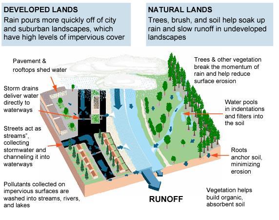
Fig -5:IllustrationoftheimpactofDevelopedLands (Urbanareas)andNaturalLands.(Source:EmilyRuby, OEHHA)
The revitalization and preservation of water canals hold immense significance for the sustainable development of urbanareasinIndia.Traditionallyviewedasrural-centric, canalshaveemergedaspivotal conduits linking rural and urbanenvironments.However,theinfluenceofurbanismon canals has been profound, leading to environmental repercussionssuchashabitatalteration, biodiversityloss, and water pollution. Two exemplary case studies, BirminghamintheUKandUtrechtintheNetherlands,shed lightonsuccessfulcanalrevitalizationefforts.Birmingham”s extensive canal network, deeply intertwined with its industrialheritage,hasundergonesubstantialregeneration, evolvingintoavibranthubforleisureandculturalactivities. While, Utrecht”s picturesque canals, lined with historic structures,serveasakeyattractionforbothresidentsand tourists, contributing significantly to the city”s unique ambiance.Throughthestudyithasbeenfoundthattemporal land-use and land-cover analyses plays a major role in determining the ambient share of landuse under canals, particularlythecatchmentareasofcanals.Hence,through thestructuralequationandIntegrationofGISthisequitable sharecanbedeterminedwhichcanbeusedtoincreasethe probabilityintourismdevelopment.
Ultimately,therejuvenationofwatercanalsisnotmerelya matter of infrastructure development, but a holistic endeavor that embraces environmental conservation, culturalpreservation,andcommunityengagement.Through strategicinterventionsandcollectiveefforts,India”scities canharnessthetransformativepowerofcanalstoachieve enduringprosperityandsustainableurbandevelopment.
International Research Journal of Engineering and Technology (IRJET) e-ISSN: 2395-0056
Volume: 11 Issue: 07 | July 2024 www.irjet.net p-ISSN: 2395-0072
IamespeciallyindebtedtoDr.SubrajitBanerjee,whoguided methroughtheresearchwork.IamgratefultoDr.Indrani Chakraborty who constantly supported me thought the inceptiontotheresearchwork.Iwishtothankmyparents for their love and encouragement, without whom I would neverhaveenjoyedsomanyopportunities.
[1] (Grameen), S. B. (n.d.). Towards a Swachh and Swasth Bharat by 2025. Retrieved from https://sbmgramin.wordpress.com/2023/02/06/alllakshadweep-villages-have-achieved-model-odf-plusstatus/
[2] David Egan, W. C. (2006). http://shura.shu.ac.uk. RetrievedfromTheIntra-urbanLocationofHotelsinthe Chinese Cities of Beijing, Shanghai & Shenzhen: https://shura.shu.ac.uk/24935/1/final%20version%20o f%20the%20hotel%20location%20paper%20Journal_6%20Paper8.pdf
[3] Li, J. (2020). Culture and tourism-led peri-urban transformation in China – The case of Shanghai. Retrieved from Cities: https://doi.org/10.1016/j.cities.2020.102628
[4] Ltd, A. O.-M. (2005). Collection of Domestic Tourism StatisticsFortheStateofRajasthan.NewDelhi:Ministry ofTourism.
[5] Portal, I. E. (2022, 11 15). Report filed by the Union Territory of Lakshadweep regarding compliance of municipal solid waste management rules, 2016, 15/11/2022.
[6] Tourism,U.P.(2015).Uttar PradeshAtoZ.Lucknow: UttarPradeshtourism.
[7] UNEP.(2022,June7).Islandnationsgetnewlifelineto beatpollution.Geneva.
[8] Soumyadeep D .Sanghamitra S, Canal-oriented development:Integratingan urbancanalfrontwiththe city,InternationalJournalofUrbanPlanning(2020)
[9] SurfaceRunoffandtheWaterCycle,WaterScienceSchool (USGS),(2019)
[10] Xu R (2014),, Research on the couple of canal cultural heritage and ecological community building, Advanced MaterialsResearch