
International Research Journal of Engineering and Technology (IRJET) e-ISSN: 2395-0056
Volume: 11 Issue: 07 | July 2024 www.irjet.net p-ISSN: 2395-0072

International Research Journal of Engineering and Technology (IRJET) e-ISSN: 2395-0056
Volume: 11 Issue: 07 | July 2024 www.irjet.net p-ISSN: 2395-0072
Neha Chigurupati1 , Akshaya Venkatesh1
1Student, Downingtown STEM Academy, Pennsylvania, United States of America
1Student, Downingtown STEM Academy, Pennsylvania, United States of America
Abstract - Unmanned Aerial Vehicles (UAVs) hold immense potential to positively impact our world: they can streamline emergency operations, deliver emergency supplies to people in floods, and monitor atmospheric conditions ruined by climate change. However, the existing UAVinfrastructurelacksastandardizedandefficientsystem for navigating through airspace. This research paper aims to design an integrated Air Highway System that streamlines UAV operations. The SkyLink Express is structured with organized pathways and airspace, with designated directional highways for each travel direction. StandardizationofUAVoperationsontheSkyLinkExpressis ensured through the integration of various sensor infrastructure, some of which include LiDAR sensors, RadarAltimeter sensors, ADS-B modules, and a GPS/INS positioning system. The advanced autonomous navigation algorithm guides UAVs along designated routes with GPS waypoints, and the collision avoidance algorithm maintains a safe distance radius of 5 meters between UAVs, utilizing instantaneous speed information communicated through the ADS-B module and distance data from Lidar sensors. This algorithm adapts to dynamic environments in realtime,ensuringthesafetyandefficiencyofUAVoperationsby making proactive decisions to avoid collisions. The SkyLink Express represents a transformative advancement in UAV technology, providing a reliable foundation for structured, safe UAV operations across their diverse applications. In conclusion, this system will ensure that the full potential of UAVs are utilized to positively impact communities worldwide.
Key Words: Unmanned Aerial Vehicle (UAV), Autonomous Navigation, Collision Avoidance, Geofencing, Flight Controller, Sensor Fusion, Automatic Dependent Surveillance-Broadcast (ADS-B), GPS Waypoints
1.INTRODUCTION
Unmanned Aerial Vehicles (UAVs), commonly known as drones, have experienced a significant increase in usage across numerous disciplines in the past few decades. They have become crucial resources in various applicationsduetotheirabilitytoperformtasksprecisely,
reachinaccessibleareas,andoperatewithminimalhuman intervention. The widespread applications of UAVs are detailedinthetablebelow.
Table -1: UAVApplications
Discipline Application Implications
Searchand Rescue (SAR) Useof imaging technology forlocating missing peoplein various terrains
Border Security Surveillance and patrolling along national borders
Military Reconnaissa nceand surveillance [4]
Environme -ntal Monitoring Useof various sensors (LiDAR,NIR, multispectra l)fordata collectionon forest structure, topography, and environment alchanges
Increasedsuccessratesin findingmissingpeople[1], fasterresponsetimes, abilitytoaccessandsurvey hard-to-reachareas,safer operationsforrescueteams [2],improvedcoordination throughreal-timedata sharing
Enhanceddetectionof illegalcrossingsand smugglingactivities, improvednationalsecurity, real-timemonitoringand quickresponsecapabilities [3]
Improvedsituational awareness,real-time intelligencegathering, reducedrisktomilitary personnel,andimproved security
Highertemporalresolution, abilitytooperateinadverse weatherconditions, detailedandfrequent observationsof environmentalchanges[5], improvedmonitoringof naturalresourcesand disastermanagement
International Research Journal of Engineering and Technology (IRJET) e-ISSN: 2395-0056
Volume: 11 Issue: 07 | July 2024 www.irjet.net p-ISSN: 2395-0072
Agriculture Crop monitoring, disease diagnosis, water quality inspection, yield estimation
Disaster Relief Damage assessment, searchfor missing people, deliveryof reliefgoods (food,water, medical supplies)in natural disasters
Fire Rescue Aerial surveillance offirezones, deployment of firefighting UAVstodrop flameretardants
CommercialGoods Delivery Package Delivery withUAVs
Improvedcrop managementandyield predictions[6],early detectionofdiseasesand pests,optimizeduseof resourcessuchaswater andfertilizers,costsavings comparedtotraditional methods,increased agriculturalproductivity andsustainability
Fasterassessmentof disasterimpact,timely deliveryofessential supplies[7],abilitytoreach inaccessibleareas[8], improvedcoordination withemergency responders,enhanced safetyforhumanpersonnel
Geological Survey Topographic almapping, hydrological modeling, monitoring geological changes
Detailedandaccuratedata collection,abilitytosurvey largeandremoteareas [14],cost-effective comparedtomanned surveys,improved understandingofgeological processes,enhanced planningandmanagement ofnaturalresourcesand infrastructureprojects
Emergency Resource Dispatch Rapid deliveryof medical suppliesand equipment in emergencies
Real-timemonitoringoffire spread[9],rapid deploymentoffirefighting measures,reducedriskto humanfirefighters, increasedeffectivenessin controllingand extinguishingfires[10], potentialtosavelivesand property
Fasterandmoreefficient deliveryservices[11], essentialgoodsdeliveredto floodedareas/natural disasterdestruction, reducedtrafficcongestion, improvedlogisticsand supplychainmanagement, potentialfor24/7delivery operations
Immediateaccesstocritical resourcesinmedical emergencies[12],potential tosavelives,faster responsetimescompared totraditionalmethods, abilitytooperateindifficult orhazardousconditions [13]
Imaging Orthomosaic and elevation data collection, wildfire monitoring, environment al monitoring
High-resolutionandrealtimedataforvarious applications,abilityto operateinchallenging weatherconditions, detailedmonitoringof environmentaland ecologicalchanges[15], improveddecision-making forconservationand management[16], enhancedabilitytodetect andrespondto environmentalhazards
Because of their widespread application, the proliferation of UAVs in the skies brings out significant challenges in managing their countless flight paths. One primary issue is the risk of mid-air collisions with other UAVs and manned aircraft. In addition, the lack of a standardized and efficient system for coordinating UAV traffic can lead to chaotic airspace, reducing operational efficiency and increasing the likelihood of UAV accidents. UAVs are set to become crucial in various industries, necessitating their safe and efficient operation. Without a strong solution, the UAV sector risks inhibiting the many benefitsitcandeliver.
To address these challenges, this research paper proposestheimplementationofanorganizedAirHighway System designed specifically for UAV management. This system aims to create structured pathways in the sky to streamline the flow of UAVs, decrease collision risks, and optimizeairspaceusage.
International Research Journal of Engineering and Technology (IRJET) e-ISSN: 2395-0056
Volume: 11 Issue: 07 | July 2024 www.irjet.net p-ISSN: 2395-0072
2.1 Current Collision Avoidance Systems in Place
Table -2: CurrentCollisionAvoidanceSystemEvaluation
System Name Key Features Evaluation Radarand Guidance Systems[17]
UsesFAAand3Dspecificradarsfor acomprehensive airpicture; Providesvisual andaudible collisionwarnings andmaneuver guidance; Advanced algorithms estimatecollision risks;Operatesfor variousUAS (UnmannedAerial Systems)sizes withoutadditional onboard equipment
Benefits: Enhancessafety bydetecting potential collisions, allowsUAVsto operatein sharedairspace, provides accurate trackingand monitoring, reduceshuman workload
Limitations: Dependenton radarcoverage andquality,high initialsetupand maintenance costs,potential inactivityissues inhigh-traffic areas,requires integrationwith existingATC infrastructure
Intel'sRealSense Technology[19]
Usesstereo camerasand depth-sensing technologyto avoidobstacles; Live3Dmapping ofthe environment;Uses advanced algorithmsfor pathplanningand collisionavoidance
DJIAirSense[18] UtilizesAutomatic Dependent SurveillanceBroadcast(ADS-B) technologyto receivesignals fromnearby aircraft;Provides instantaneous alertstoUAV operatorsabout thepresenceof mannedaircraft; Displaysthe aircraft'slocation ontheUAV controller'sscreen
Benefits: Enhances situational awarenessby providingrealtimealerts,easy integrationwith existingDJI drones, improvessafety inshared airspace
Limitations: ReliesonADS-B signals,which notallaircraft maybroadcast; canbelimited bytherangeand accuracyofADSBreceivers, effectiveonly whenother aircraftare equippedwith ADS-B transponders
Benefits: Providesrobust obstacle detectionand avoidance, effectiveina varietyof environments, includingindoor andoutdoor, enhancesUAV autonomyand safety.
Limitations: Requires significant computational power,limited bytherangeand accuracyofthe sensors,may struggleinlowlightconditions orwithhighly reflective surfaces
To establish a safe and efficient infrastructure with the widespread use of UAVs, several gaps must be addressed. First, many UAV collision avoidance systems are not fully integrated with existing ATC infrastructure. This lack of integration causes communication breakdowns and coordination challenges between manned and unmanned aircraft, leading to potential safety risks. Additionally, UAV collision avoidancesystemsoften rely on radar or depth-sensing technologies, which can be limited by range, environmental conditions,andsignal reliability.Collisions will also increase due to incomplete coverage or signal interruptions which lead to gaps in the UAV's situational awareness. This high computational power demand may further limit the operational endurance and efficiency of UAVs, more so in smaller models with low battery capacity. Specific environments, such as low light conditions or those with high reflectivity, are challenging for sensor-based collision avoidance. Those types of environments will reduce sensor performance, reducing the detectability and avoidability of obstacles by a UAV.
International Research Journal of Engineering and Technology (IRJET) e-ISSN: 2395-0056
Volume: 11 Issue: 07 | July 2024 www.irjet.net p-ISSN: 2395-0072
This also presents the biggest challenge: standardization amongdifferentUAVcollisionavoidancesystems.Without standardized protocols and systems, ensuring that all UAVswillbeabletocoordinatewithoneanotherbecomes difficult increasingtheriskofmid-aircollisions.
Recent advancements in autonomous UAV navigation have significantly enhanced the capability, efficiency, and safety of UAVs. These developments contain a wide range of innovative algorithms and technologies aimed at improving the precision and reliabilityofUAVoperations.
Table -3: TechnologicalAdvancementsinUAVNavigation
Technology Development Impact Machine
Learning(ML) andAI
Integration[20]
MLandAI algorithmsare beingintegratedat agrowingpace intonavigation systemsofUAVs. Thesetechnologies notonlygivea UAVtheabilityto learnfromits environmentbut alsoincreaseits decision-making abilitiesovertime.
SLAM (Simultaneous Localizationand Mapping)[21]
SLAMalgorithms canbeusedto enableaUAVto buildandupdatea mapofan unknown environmentwhile keepingtrackofits locationinside.
AI-driven navigation allowsaUAVto forecastand respondmore efficientlyto dynamic obstaclesand changesinthe environment, thereby enhancingthe safetyand efficiencyof UAVoperations.
Thisisacritical capabilityin GPS-denied environments, suchas navigation indoorsor underground, forautonomous navigation. SLAMincreases theabilityofthe UAVtonavigate preciselyand avoidobstacles instantaneously.
SensorFusion [23]
currentlybeing optimizedforuse inUAV applications.The approachesenable findingthemost effectiveand collision-free pathsthatUAVs shouldflythrough. efficientlyin complex environments, while minimizing energy consumption andtraveltime, byavoiding obstacles.
Sensorfusion techniques combinedatafrom manydifferent sensors,including LiDAR,cameras, andIMUs,Inertial Measurement Units,providingan understandingof thesurroundings ofaUAV.
Decentralized Navigation Systems[24]
PathPlanning andOptimization [22]
Theseare advancedpath planning algorithms,suchas A*andRRT,
Improvedpath planningwill thereforeenable aUAVtoselfnavigate
Adecentralized navigationsystem isasystem whereinanumber ofUAVscouldact togetherwithout beingcontrolled byonecentral unit.Distributed algorithmsfor exchanging informationand makingcollective decisionsareused indecentralized navigation systems.
Itenhancesthe accuracyofthe navigation systeminstalled intheUAV, makingitmore reliablethrough sensorfusion, andthereby providesmore accurate obstacle detectionand avoidance.
Thisenhances thescalability andstrengthof UAVfleets, finallyallowing themtoexecute complex missionsand carryingout taskssuchas searchand rescueorlargearea surveillance.
UAVs often struggle with navigation in diverse and unpredictable environments. These environments pose significant challenges due to GPS signal obstruction, dynamic obstacles, and complex terrain. Real-time decision-makingiscriticalforcollisionavoidanceandpath planning. However, current systems can experience latency issues, especially in high-traffic areas or when processing large amounts of sensor data. This latency can reduce the effectiveness of navigation and collision avoidance systems. Current decentralized navigation
Volume: 11 Issue: 07 | July 2024 www.irjet.net
systems need further development to handle large-scale UAV operations effectively. Ensuring that multiple UAVs can operate in coordination without central control remains a challenge, particularly in terms of information sharing and collaborative decision-making. While sensor fusion enhancesnavigationaccuracy,italsocomes with limitations. Combining data from various sensors (LiDAR, cameras, IMUs) can be complex and may still result in errors due to sensor malfunctions, data inconsistencies, or environmental factors like poor lighting or reflective surfaces. The deployment of autonomous UAVs raises various ethical and regulatory concerns, such as privacy, surveillance, and the safe integration into public spaces. Addressing these issues requires comprehensive policies and international cooperation. By identifying and addressing these gaps, advancements in autonomous navigation infrastructure can continue to improve, leading to safer and more efficient UAV operations across various industries and applications.
EXPRESS
3.1 Key Terms
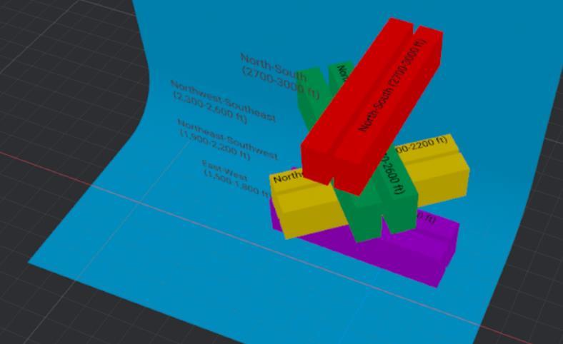
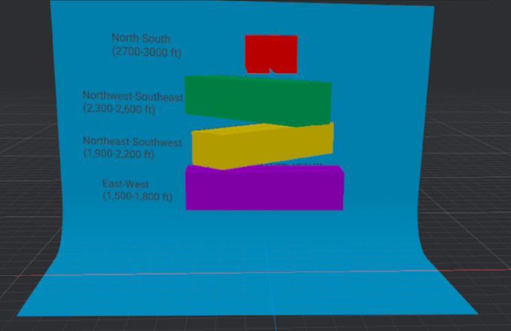
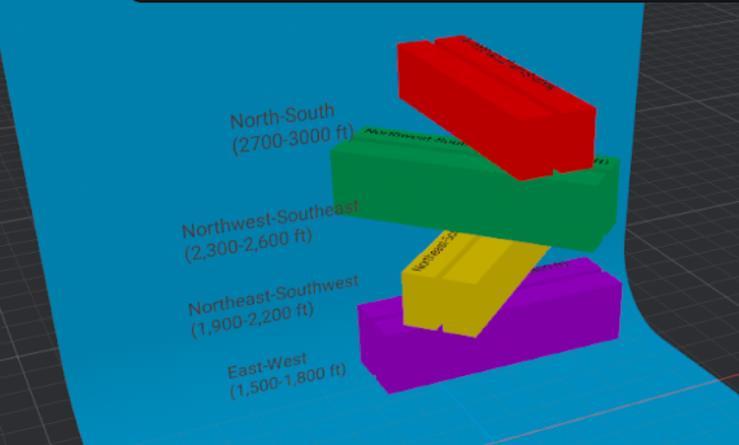
Table -4: KeyTermsfortheSkyLinkExpress
Directional Highways Divided Lanes SkyLink Express
Directional highwaysreferto the levels that this highway system contains. These altitude levels were strategically chosen after considering tall structures and commercial planes.
East-West(15001800ft)
NE-SW(19002200ft)
NW-SE(23002600ft)
North-South (2700-3000ft).
Just as in a normal highway, the SkyLink Express has divided lanes oneachdirectional highway for UAVs going in opposite directions. For instance, on the East-West highway, there are divided lanes for UAVs going EastWest and vice versa.
Refers to one holistic air highway system, consisting of 4 directional highways and 8 divided lanes (2 on each highway).One SkyLink Express located in every state.
Each SkyLink Express is organized regionally by state; SkyLink Expresses will be implemented solely within the United States, but future avenues may involve global expansion. Within each state's SkyLink Express, UAVs may have different applications according to that state’s particular UAV needs, but common applications such as delivery and emergency response are commonly
International Research Journal of Engineering and Technology (IRJET) e-ISSN: 2395-0056
Volume: 11 Issue: 07 | July 2024 www.irjet.net p-ISSN: 2395-0072
applied across all SkyLink Expresses. For instance, rural states such as Vermont may further emphasize agricultural and environmental applications UAVs as compared to a more urban region such as California, which may place more emphasis on commercial delivery. Nonetheless, UAVs are encouraged to travel into neighboring states’ SkyLink Expresses, improving connectivityandallowingforfarthertravelroutes.

To ensure that UAVs on this system can coexist with existing aircraft infrastructure, a centralized air traffic control (ATC) system is used to streamline UAV navigation and ensure that they are aware when other aircraft travel across the SkyLink Express’s directional highways. This centralized ATC system, hosting commercial plane signals and UAVs on it, allows for coordinatedtravelroutesthatimprovesafetybetweenthe twoaircraft’stravelpaths.
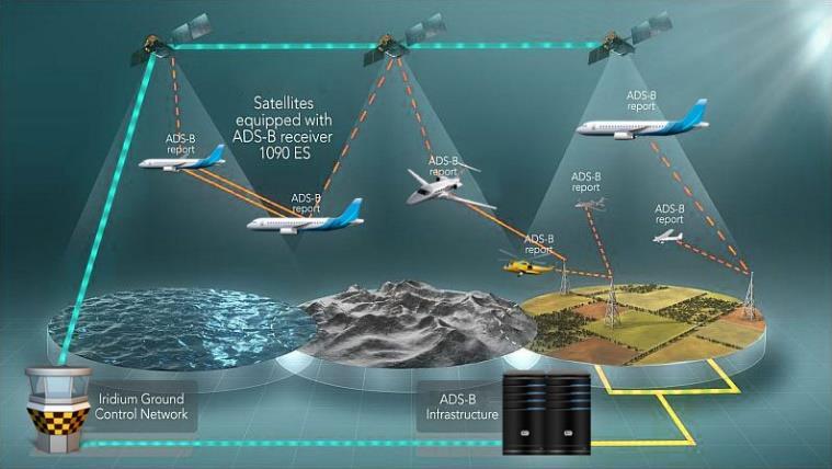
TheprimaryinfrastructureforATCintegrationon the SkyLink Express is an emerging technology known as Automatic Dependent Surveillance Broadcast (ADS-B); these transmitters consist of two primary parts: ADS-B Out and ADS-B In. ADS-B Out is a surveillance technology fortrackingaircraft - it's whatATCusestomanagetraffic [25]. These transmissions are broadcasted once per second [26] at a 1090 MHz frequency [27]. This is the module equipped on the UAV that communicates GPSderived location, altitude, velocity data once per second. Satellites equipped with ADS-B receivers in low Earth orbit(LEO)capturetheseADS-Bsignals,thenrelayingthis received ADS-B data to ground stations. Ground stations processtheADS-BdataandsendittoATCcentersforrealtime tracking and management of air traffic. Using this instantaneous position data, air traffic controllers can display UAVs on an ATC system using unique identifier codes. The relevant identifier codes used in ADS-B transmission systems are ICAO 24-bit addresses, which are assigned by the International Civil Aviation Organization [28]; each UAV possesses its own unique code in order to be identified. With the information that UAVs provide, ATC’s can monitor aircraft flight paths and transmit information to UAVs again in the case of emerging dangerous weather conditions, changing air trafficconditions,oroncomingcommercial aircrafttraffic. This process allows ATC to regulate air traffic and ensure thattheSkyLinkExpressinfrastructurecanoperate safely alongsidecommercialaircraft.
ADS-B In receivers are also equipped onto all UAVs, and this involves a UAV receiving transmissions from ADS-B ground stations and/or other UAVs in the surrounding area [29]. UAVs in a concentrated area can receive ADS-B transmissions from other UAVs in the area containing GPS position, velocity, and altitude. By obtaining this information from nearby UAVs, each UAV can determine the relative positions of others, aiding in collision avoidance decision-making; this information is also directly used in the collision avoidance algorithm. When UAVs in a localized area receive messages from ground stations about oncoming commercial aircraft traffic, they follow relevant right-of-way rules, stopping andyieldingtothecommercialaircraft.
Traditionally,ADStransmissionsareprocessedby pilots aboard the aircraft that uses the module, but in the caseofUAVs withoutpilots, the processing system within their flight controllers will interpret the ADS transmissions and take necessary action. To ensure compliance with current FAA regulations on ADS-B systems, backup UAV remote operators will maintain communication with ATC through the ADS-B transmission.
Volume: 11 Issue: 07 | July 2024 www.irjet.net p-ISSN: 2395-0072
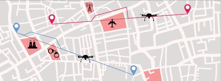
To prevent UAVs from crossing unauthorized national borders, such as those between the U.S. and Mexico or Canada, there is one horizontal highway lane along the border, solely designated for UAVs securing the border. The SkyLink Express will be compatible with bordersecurityUAVs,astheywillmonitorbordersecurity along one designated altitude level across the border. In order to ensure regulatory compliance over borders and other restricted areas, the SkyLink Express utilizes a geofencing management system for border control and designated no-drone zones. Polygonal geofencing is defined by a series of reference points and forms a polygonal shape withmultiplevertices[30]. The geofence is created by specifying the GPS coordinates of multiple points in sequence to form the polygon. Specifically, to geofence the border, we are using the latitude and longitude coordinates along the border to create a polygonal geofence. A geofencing management system is used to establish these geofences as part of the UAV’s flightcontrollersystem[30].Thissystem,connectedtothe UAV’s control interface, will continuously monitor its instantaneous position relative to the defined geofences. In the case that a violation occurs, the system triggers alerts, and the UAV maintains a distance from the unauthorizedarea.Thepartsofageofencesysteminclude the latitude and longitude reference points, which define the boundaries of the geofence, and the software or applicationusedtosetandconfiguretheseboundaries,as wellastomanagethedrone’sresponseswhengeofencing isactivated.Between each bordercrossing opening, UAVs willgobackandforthbetweenthetwoareas.Thespecific latitudeandlongitudecoordinatestocreatethepolygonal geofence will be the edge of both border crossing center andintoeachsideofthecountry.Thefigurebelowdetails thegeofencingmethodtoensurebordersecurity.
UAVs on the SkyLink Express utilize a navigation system that relies on a combination of GPS (Global Positioning System) and INS (Inertial Navigation System) technologies.GPS, widelyusedforitsglobal coverage,isa very reliable navigation source, but its precision can be limited by the number of available satellites within the
vicinity of a given GPS receiver. Areas where the GPS signal cannot obtain information from nearby satellites areknown asGPS black spots[31].An Inertial Navigation Systemusesaccelerometerstomeasurespecificforcesand gyroscopestomeasurerotationalrates,updatingposition, velocity,andorientationfromagivenUAV’sinitialstarting position; as the UAV starts its flight, the position vectors adjustaccordingly.Alimitationofthistechnologyisthatit can experience integration drift problems due to propagating bias errors [31]–systematic errors or deviations in sensor measurements that accumulate over time. These small errors in calculated acceleration and angularvelocitydevelopoverthecourseoftheflightpath, causing significant errors in velocity and positioning. To mitigatethesedrifterrors,thesedrones’INSoftenrelyon external information from GPS technology to substantiate its collected information. Therefore, combining GPS with INS technology helps balance their respective limitations, ensuring a more holistic, reliable navigation system for UAVs in which one can take over when the other isn’t properly functioning. In the case that both of these technologies fail,manual override will occur by the UAV’s owner/operator. The UAV operator finds the nearest landing area to fix the navigation systems. It is very important that this navigation system is standardized across all UAVs in order to ensure that UAV safety is maximized and collisions are minimized; therefore, these twonavigationsystemswillberequiredoneveryUAVthat travelsonthisairhighwaysystem.
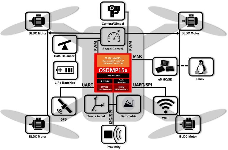
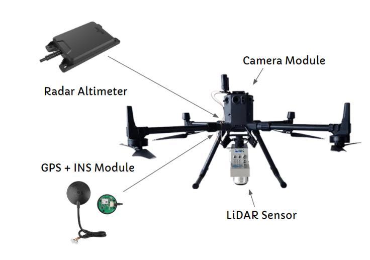
Standardization between UAVs is essential since they are functioning independently on this air highway systemandneedtooperatesafelyandbecompatiblewith the necessary autonomous navigation & collision avoidance algorithms. Standardization in the SkyLink Express is ensured through a standardized flight controller and processing software system, while mandating certain sensors to be equipped onto all UAVs. The table below details each aspect of the sensor infrastructure.
Table -5: StandardizedSensorInfrastructure
Sensor Infrastructur -e Uses
LiDARsensor standardizedsensorfor measuringthedistancebetween UAVs,providingprecisedistance informationcrucialforour collisionavoidancealgorithm (seeSection6).
LiDAR’shighmeasurement rangeandaccuracycontributeto
International Research Journal of Engineering and Technology (IRJET) e-ISSN: 2395-0056
Volume: 11 Issue: 07 | July 2024 www.irjet.net p-ISSN: 2395-0072
reliabledistancemeasurements, offeringadetailedand dependabledatasetforeffective collisionavoidancestrategies [32]
ThedatacollectedbyLiDAR sensorsisprocessedthroughour collisionavoidancealgorithms, enablingreal-timedecisionmakingtoavertpotential collisionsandensuresafe navigation.
Camera Module
Radar Altimeter
ADS-BOut Module
Theradaraltimeterprovides accuratealtitudemeasurements, ensuringthatUAVsmaintainsafe flyingheightswithinthe designatedaltitudelevelsofthe highwaysystem.
Theimmediateandaccurate altitudedatafromradar altimetersfacilitatereal-time decision-making,enablingUAVs toautonomouslystaywithinthe designatedhighwayboundaries outlinedbyourautonomous navigationprogram.
Every1second,thesemodules transmitUAVpositioning informationlikeGPSposition, velocity,altitudetoground stations,satellites,andUAVs withinthevicinity
Thisinformationisusefulforairtrafficcontrolmanagementand foryieldingtocommercial aircrafttraffic(seeSection3Bfor moreinformationonair-traffic controlmanagement)
Inertial Navigation System
Thecameramoduleisusedfora varietyofapplicationsfrom searchandrescuemissions identifyingthetargetto agriculturalmissionsidentifying thediseasedplants.Thespecific softwareneededwillbe downloadedtoworkwiththe cameramodulebasedonthe UAVoperators’needs.
Thecameramodulewillalsoaid duringmanualoverrideifit comestoitforoperatorsto navigatetheairspaceand surroundings.
Thissystemisusedto supplementGPStechnologyon allUAVS;itinvolvescalculating positionvectorsbasedon displacementfromaUAVsinitial position.
There is no specific standardized flight controller system, but the primary requirement is that the flight controller has to be compatible with the required sensor infrastructure. UAV users will be required to equip UAVs with a flight controller that can integrate the mandated sensor infrastructure. Once a UAV becomes registered onto the SkyLink Express’s system and passes all initial checks and inspections for safety, the UAV’s user is provided the unique processing system and algorithms needed to operate within the air highway system. These algorithms are then uploaded onto the UAV’s flight controller.
ADS-BIn Receiver
GPSReceiver
Thesereceiversareusedto receiveimportantmessages fromairtrafficcontrollersabout oncomingcommercialaircraft traffic.
Thesereceiversalsoreceive ADS-Btransmissionsfromother UAVsabouttheirpositioning, allowingeachUAVtobeaware ofotherUAVs’relativepositions.
Thesereceiversareutilizedto processGPSinformationfrom satellitesandmaintain positioninginformation
International Research Journal of Engineering and Technology (IRJET) e-ISSN: 2395-0056
Volume: 11 Issue: 07 | July 2024 www.irjet.net p-ISSN: 2395-0072
Given the urgent need to address global warming concerns, it is crucial that this large-scale use of UAVs utilizessustainableenergysourcestominimizethecarbon footprint of UAV operations. However, since a standardized energy source for the entire system is difficult to implement right away, the SkyLink Express aimstoachievefullsustainableenergyusagebyPhase3of Implementation (see Section 7 for implementation information).
Space-basedsolarenergyharnessestheSun'srays fromouterspace,deliveringanintensityapproximately10 times greater than terrestrial solar panels [33]. This system operates through satellites equipped with microwave-transmitting technology, where large mirrors within the satellite reflect sunlight and convert it into an electric current. The converted energy is then beamed to Earth using a targeted laser beam that is received by outdoor solar panels at a facility. These panels transform the laser beam back into solar energy, which serves as a sustainable and efficient power source for UAVs [34]. Lithium-ion batteries within the facilities are directly powered by the transmitted space-based solar energy, providing a continuous and renewable energy supply for UAVoperations.
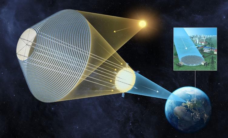
To further enhance sustainability, small wind turbines are integrated into the UAVs’ exterior design to harness wind energy at high altitudes. This dual functionality allows the UAVs not only to carry out their operations but also to contribute to sustainable energy practices. The electricity produced by these turbines can bestoredforuseinotherlocations,contributingtoamore energy-efficient UAV system. The primary part of this energy system that will eventually be required of UAVs is the solar energy powered batteries. This approach aligns withthisproject’scommitmenttomaximizeefficiencyand minimizetheenvironmentalimpactofUAVoperations.
Without on board pilots, there needs to be a way for UAVs to process data independently in order to make real-timedecisionswhilenavigatingairspace.Therefore,a processing system to integrate all of its independent functions is crucial to UAV operations’ success. On the SkyLink Express, standardization is necessary to streamline operations across a variety of different UAV models.However,sinceit’sdifficulttostandardizesensors and every system on the UAV, standardizing the processingsoftwarethatisthenequippedontoUAVflight controllers is more practical. Not only do the flight controllers control the drone's orientation using sensors (gyroscopes & accelerometers) and manage the drone's height using barometric pressure sensors and GPS data, but also will aid in navigation and guidance. While the radar altimeter detects the height the UAV must be, the barometricpressuresensorkeepstheUAVhoveringatthe specific height, ensuring no movement vertically. The flightcontrollerusesInertialMeasurementUnits(IMU) to combine accelerometer and gyroscope data to measure the drone's movement and orientation as well as GPS modules to provide location data for navigation and positioning. All data will be stored on the flight controller aiding communication between UAVs, transmitting altitude, speed, battery level, and more data. Because of autonomouscontrol,theflightcontrollerwillexecutepre-
International Research Journal of Engineering and Technology (IRJET) e-ISSN: 2395-0056
Volume: 11 Issue: 07 | July 2024 www.irjet.net p-ISSN: 2395-0072
programmed missions or respond to real-time data and sensorinputsautonomously.Moreofthepre-programmed missions will be discussed in the Autonomous Navigation InfrastructureandCollisionAvoidanceProgramsections.
TheSkyLinkExpress’snavigationsystemrelieson positioningdatafromGPS(GlobalPositioningSystem)and INS (Inertial Navigation System) to navigate flight paths. The GPS provides accurate positional data (latitude, longitude, and altitude) by receiving signals from satellites.INSusesaccelerometersandgyroscopestotrack theUAV’sposition,orientation,andvelocity.Thisiscrucial forprovidingcontinuous navigationdata, especiallywhen GPSsignalsareweakorunavailable(seesection3.4).The flight controller integrates data from these 2 navigation sources to form a comprehensive understanding of the UAV's current position and movement. Algorithms within theflightcontrollerprocessthisdatatocontinuallyupdate theUAV'sposition.Basedonthedata,theflightcontroller calculates an efficient route to the UAV’s next waypoint/destination. Utilizing the geofencing polygons, the autonomous navigation system stores these coordinates as unauthorized areas and will adjust UAV pathstoavoidtheseareas.
4.2
The autonomous navigation infrastructure of UAVs involves sophisticated systems to ensure safe and efficient flight paths without human intervention. The processed data sources include GPS waypoints which are pre-programmed coordinates that the UAV follows to reach its destination and altitude data (obtained from barometric sensors and GPS modules) which determines the UAV’s altitude level; these sources of information are needed for avoiding collisions and following designated directional highway and lane constraints. The flight controller receives signals from GPS satellites to determine its current position. Based on the waypoints and altitude data, the flight controller adjusts the UAV's flight path and altitude based on the autonomous navigationprogram.Thevariablesintheprogramaltitude levelandwaypointfunctionstriggerthesesignalstorunin the flight controller. The autonomous navigation algorithm ensures that the UAV follows its preprogrammedroutewhiledynamicallyadaptingtochanges intheenvironment,suchasavoidingobstacles.
Effectivecollisionavoidanceiscriticalforthesafe operation of UAVs. The data sources for processing are ADS-B (Automatic Dependent Surveillance-Broadcast) which provides real-time data about nearby aircraft, includingtheirspeedandpositionandothersensorssuch
as radar, LiDAR, and cameras, which detect obstacles in the UAV’s path. The flight controller processes data from ADS-B and other sensors to identify potential collision threats. In the program, the variable UAV1.speed will collect data from ADS-B for UAV2’s speed and this will signalthecollisionavoidancealgorithmtoassesscollision risk and calculate necessary evasive maneuvers in the flight controller. The flight controller prompts the UAV to change its altitude, speed, and direction to avoid the obstacleastheprogramprompts.
UAVs must interpret and respond to signals from airtrafficcontrol(ATC)tosafelynavigatesharedairspace. UAVsequippedwithADS-Breceiverscaninterpretsignals from ATC, including commands for altitude changes or course corrections. The flight controller decodes these signals and responds to ATC commands using the UAV’s navigation system. The UAV then adjusts its flight path or altitudeasdirectedbyATCtoavoidconflictswithmanned aircraft or other external circumstances. The processing system ensures that UAVs adhere to airspace regulations and respond appropriately to ATC commands. UAVs require ADS-B Out to broadcast their position and ADS-B In to receive data from other aircraft and ATC. This capability ensures comprehensive awareness and compliance with regulatory requirements. By standardizing flight controllers and integrating sensors and processing algorithms, UAVs can navigate complex airspaces autonomously, avoid collisions, and adhere to ATCinstructionseffectively.
Unlike traditional transportation systems, where visiblemarkerssuchassignsandroadwaysguidevehicles, UAVs operate in three-dimensional airspace without physical boundaries. Since they are unmanned, UAVs require programmed coordinates to ensure that they remain on their routes and complete their missions successfully. The SkyLink Express’s autonomous navigation infrastructure is critical to ensuring that UAVs remain on their pre-programmed routes, contributing to enhanced operational efficiency, safety, and coordination. To stay on its flight path, UAVs on the SkyLink Express follow programmed GPS waypoints, which serve as reference points to navigate their routes. GPS waypoints are specific geographic locations defined by precise latitude and longitude coordinates, which are recorded with a precision of 5 decimal places in order to reach precise building/location coordinates. These waypoints are pre-programmed into the UAVs’ navigation system, creating a path that the UAV must follow to reach its
International Research Journal of Engineering and Technology (IRJET) e-ISSN: 2395-0056
Volume: 11 Issue: 07 | July 2024 www.irjet.net p-ISSN: 2395-0072
destination. Since each directional highway dictates different travel directions, the program considers the altitude level changes necessary for the UAV to reach its finaldestination.
To ensure safe operations, these waypoints are generated using emerging AI technology that has been on theriseinATCapplications:demandprediction[35],akey component of this AI technology, is used to forecast the numberofaircraftthatwillbeflyinginspecificairspaceat a specific time. This information is crucial for setting safe GPS waypoints that can help UAVs proactively avoid collisions with other aircraft. By analyzing historical ADSBtransmissions(whichincludeGPSpositioning&altitude data) to the ATC center and real-time data from UAVs on specific altitude levels, AI algorithms predict future demand on directional highways and Expresses to accordingly adjust UAV paths. Time series analysis is one method by which AI is utilized for demand prediction in ATC: this technique involves analyzing historical data on flight schedules, passenger demand, and climate patterns toidentifytrends,whichcanthenbeusedtopredictfuture demand. By using machine learning algorithms such as neural networks, we can analyze large amounts of data andtrendsthatarenoteasilyvisibletohumans.AIisalso integrated with UAVs’ Automatic Dependent SurveillanceBroadcast (ADS-B) modules to provide real-time data on aircraft positions, allowing for more accurate demand predictionsandoptimizedUAVpathplanning.
5.2 Autonomous Navigation Program Methodology
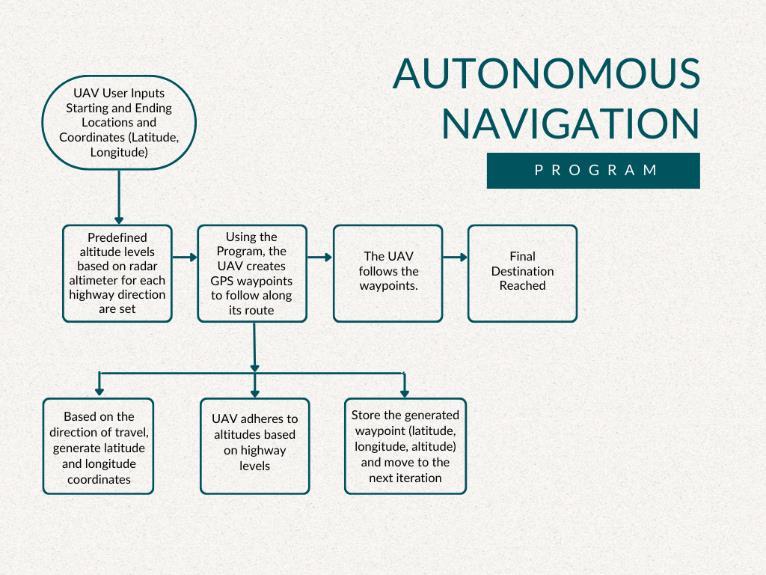
Fig -10: AutonomousNavigationProgramMethodology
The program computes different altitude levels for UAVs to maintain safe separation from other UAVs traveling in opposite directions and obstacles such as tall buildings. As previously mentioned, these altitude levels are associated with specific directional highways (e.g.,
East-West, North-South) as explained in Section 3. Based onthestartandfinal (latitudeand longitude)coordinates inputtedbytheuser,theprogramdeterminestheprimary direction of travel. The waypoints between the start and final coordinates are then generated with AI demand prediction information, adding variability to the UAV's path while maintaining the overall direction. Each waypoint is assigned an altitude within the range of the designated directional highway, determined by the direction of travel. This ensures that the UAV follows a designated altitude level, helping to manage airspace effectively. As the UAV travels between waypoints, the program monitors altitude changes and acts when a lane change is required, which involves transitioning between different directional highways on the system to maintain the correct direction and avoid collisions. The UAV continuously tracks its position using GPS and INS, adjusting its course as necessary to stay on the preprogrammed path. Key parts of the program (generating waypointsandtheforloopconditional)areshownbelow.
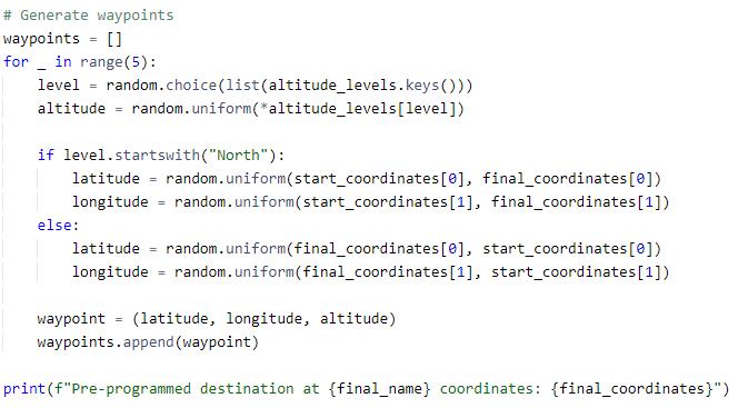
Thissectionofthecodefirstcreatesanemptylist ‘waypoints’ and initializes it to store the generated waypoints.Theloopruns5times,generating5waypoints fromthecourseofthefirstlocationtosecondasUAVsare traveling within their state. If longer tracks occur, the for loop will adjust and generate more waypoints to fit the course. A random altitude level (1 of the 4 designated altitude ranges) is then chosen from the ‘altitude_levels’ dictionarykeysinordertosettheUAVsstartingaltitudein the corresponding level. Depending on whether the selected level's name starts with "North" or not, the latitude and longitude are chosen from different ranges. For "North", latitude and longitude are chosen within the range from start_coordinates to final_coordinates. For other directions, the range is from final_coordinates to start_coordinates. For other directions, the range is reversed to accurately represent their respective travel directions.Atuple(latitude,longitude,altitude)iscreated and appended to the waypoints list to create the waypoints.
International Research Journal of Engineering and Technology (IRJET) e-ISSN: 2395-0056
Volume: 11 Issue: 07 | July 2024 www.irjet.net p-ISSN: 2395-0072
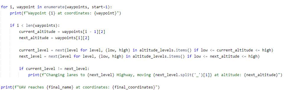
The next section of code prints each waypoint withitsindexnumber.Foreachwaypoint,thecurrentand next altitudes are retrieved from the ‘waypoints’ list. The altitude levels corresponding to the current and next altitudes are then determined. If the current and next levels are different, a lane change message is printed, indicating the direction and altitude of the change. The code output for this program is shown below. Let us take an example of an emergency delivery from the UPMC ShadysideHospitalinPittsburghtotheChildren’sHospital ofPhiladelphia.
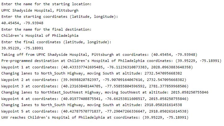
As seen, the program displays the waypoints the UAVfollowsaswellasthechangeinaltitudelevelswhena different direction is needed, printing the coordinates. It successfully travels from its starting coordinates to final coordinateswiththeprogram’smethodology.
6. COLLISION AVOIDANCE PROGRAM
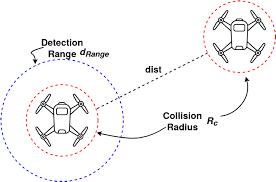
Fig -11: DetectionRangeforCollision
Table -6: KeyTermsforProgramUnderstanding
Term
UAV1
UAV2
Obstacle Direction
Collision Avoidance Direction
Speed Multiplier
SpeedRanges (m/s)
ADS-BIn Receiver
Definition
selfUAV(itself)
approachingobstacleUAV;can approachfromthetop,bottom, left,right,front,orback directions
thedirectionfromwhichUAV2, theobstacleUAV,isapproaching UAV1
determinedusinginformation fromthe6LiDARsensorsplaced ondifferentpartsofeveryUAV (front,back,top,bottom,left, right)
thedirectionUAV1travelsinto avoidcollisionwithUAV2
theadjustmenttoUAV1’s currentspeedinordertoavoid collisionwithUAV2
thismultipliercanbegreater thanorlessthanUAV1’scurrent speed(Iteration1&2takeUAV 2’sspeedintoconsideration whendeterminingthenecessary speedmultiplier)
LowSpeed:9<=x<=13
MediumSpeed:14<=x<=27
HighSpeed:27<=x<=36
receivermoduleequippedon everyUAVwithinthissystem thatreceivesADS-B transmissionsfromotherUAVs initsvicinity
allreceivedtransmissions containotherUAVs’GPS position,velocityinformation, altitude,etc.
relevantinformationforthe collisionavoidancealgorithmis thevelocityinformation;usedto makenecessaryspeedmultiplier adjustmentstoavoidcollisions
The primary objective of the collision avoidance program is to ensure the safety of UAVs operating within shared airspace. This involvesprocessing sensor data, recognizingobstacles,andexecutingavoidancemaneuvers without human intervention. By preventing collisions, the
International Research Journal of Engineering and Technology (IRJET) e-ISSN: 2395-0056
Volume: 11 Issue: 07 | July 2024 www.irjet.net p-ISSN: 2395-0072
programaimstoprotectbothUAVsandanyindividualsor property on the ground. The program is designed to manage the flow of UAV traffic efficiently by setting different speed ranges and allowing UAVs to accordingly adjust their individual flying speed in order to avoid collisions,ensuringthatUAVscancompletetheirmissions without unnecessary delays or reroutes. The 3 speed rangesareasstatedinthetableabove.
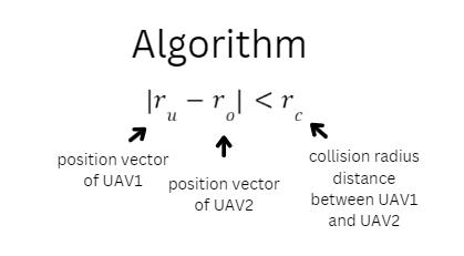
Fig -12: ProgramAlgorithm
The collision avoidance uses the sense and avoid method which adapts to specific constraints. This algorithm gives a specific constraint for the distance between UAVs to be less than the collision radius which for safety is 5 meters; our program incorporates this algorithmthroughaconditionalstatement.
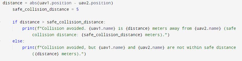
This code turns the sense and avoid algorithm into code by taking the absolute value of the distance between the two UAVs, and if above a safe collision distance of 5 meters, the program detects no collision warning. Otherwise, a distance warning occurs and collision avoidance is performed. The program relies on LiDAR sensors and ADS-B In transmissions to communicate distance and speed data from UAV to obstacles. Because the ADS-B Out transmissions are broadcastedoncepersecond,ADS-BInreceiversmounted oneveryUAVarecontinuouslyreceivingGPSandvelocity informationfromUAVsintheirsurroundingvicinity.With this positioning information, every UAV can create a mental map of the UAVs around it and be aware of any UAVs that are coming within 5 meters of distance. This program’smethodologybeginswithUAV1sensingUAV2 within 5 or fewer meters of distance. This is followed by UAV 1 determining UAV 2’s instantaneous velocity in order to appropriately adjust its own speed to avoid the collision with UAV 2. UAV 2’s instantaneous velocity is determined using information from ADS-B transmissions received by the ADS-In receiver. This then triggers both
UAVs at risk of collision to act using the collision avoidancemethodology,whichisdisplayedbelow.
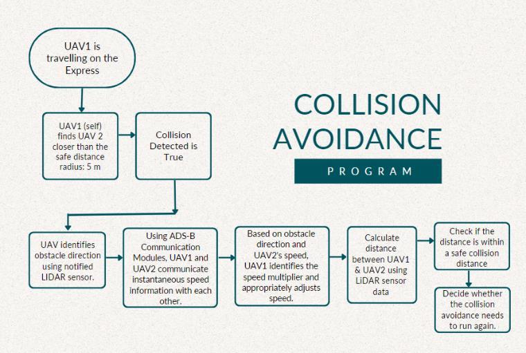
-13: CollisionAvoidanceProgramMethodology
With this program methodology of the original program, the program generalizes all the different speed combinations and UAV 1 adjusts its speeds by the same multiplier regardless of whether UAV 2’s speed is low, medium, or high speed. Therefore, this initial algorithm was not specific enough to each unique case of speed combinations between UAV 1 & 2. Specifically, if UAV 2 coming behind UAV 1 is traveling twice as fast as UAV 1, UAV 1 should move twice its current speed to adjust and UAV 2 should slow down to half its current speed. Although it includes different cases for each direction, these generalized speed multipliers were not specific enough to successfully avoid collisions. Therefore, the efficiency success rate for the original program was very low(~30%).
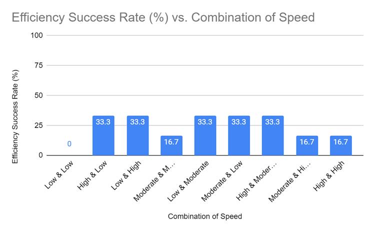
Fig -14: EfficiencySuccessRatevs.CombinationofSpeed forOriginalProgram
These low results for different speed combinations between the obstacle and UAV show the
International Research Journal of Engineering and Technology (IRJET) e-ISSN: 2395-0056
Volume: 11 Issue: 07 | July 2024 www.irjet.net p-ISSN: 2395-0072
failure in the original program to efficiently avoid collisions. Additionally, the directional efficiency is displayed below, showing failure in left, right, top, and bottomobstacledirections.
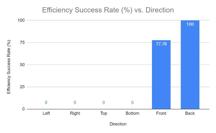
-15: EfficiencySuccessRatevs.DirectionforOriginal Program
This is due to the program keeping the obstacle avoidance direction to the opposing directions of the obstacle. Specifically, if UAV 2 is approaching UAV 1 from above when switching into a lower directional highway, UAV 1 cannot simply move down as it cannot go too far into the directional highway below, making it an unsuccessful maneuver to avoid the collision. This issue wasaddressedinIteration 1bystandardizingall collision avoidancedirectionstoforward.
To increase the efficiency success rate, a case by case approach based on each direction and specific combination of speeds of the 2 UAVs was implemented. Thisinvolvesassigninguniquespeedmultipliersbasedon UAV2’sspeedrange(low,medium,&high).Thisincreases the program’s efficiency as the speed multiplier depends on a much more specific scenario which yields more accurateresults.Belowisonedirectionwhichimplements this method; this is also done for all 6 directions which representtheLiDARsensorsdetectingthecollision.
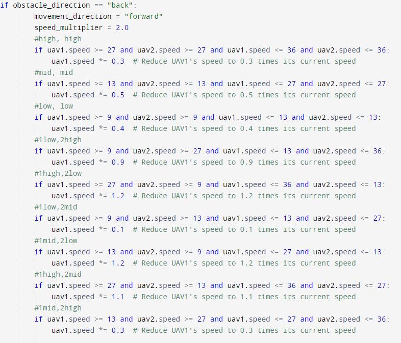
This code excerpt displays how the program identifiesthespeedrangesfromlow(9to13),mid(14 to 27),andhigh(28to36).Basedonthespeedcombinations, collisionavoidancediffers:ifUAV2approachingfromthe backistravelingtwicethespeedofUAV1,UAV1willneed a greater speed multiplier to avoid the collision. As the scenario differs for each situation, this program is specifically avoiding collisions based on different speed combinations as well as the different obstacle directions. This results in a much higher efficiency success rate shownbelow.
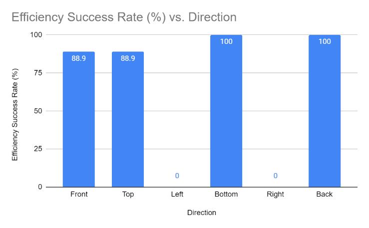
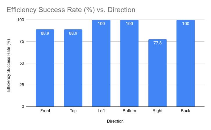
-16: EfficiencySuccessRatevs.DirectionforIteration 1
Highresultswereyieldedforalldirectionsexcept leftandrightduetotheobstacledirectionsinthe leftand right directions being the opposing directions. This issue wasfocusedoninIteration2.
International Research Journal of Engineering and Technology (IRJET) e-ISSN: 2395-0056
Volume: 11 Issue: 07 | July 2024 www.irjet.net p-ISSN: 2395-0072
6.3 Iteration 2
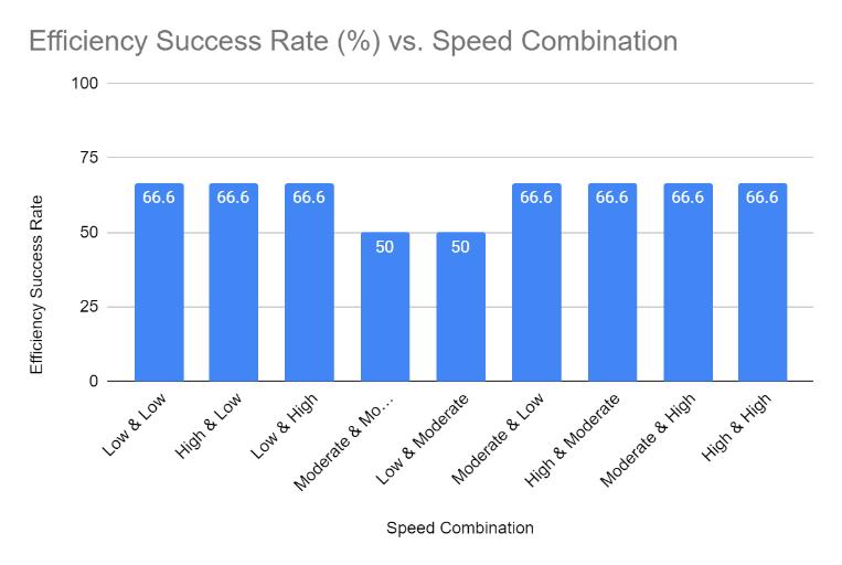
The issue of directional efficiency was mostly addressed in Iteration 2. The left and right obstacle directionswerecausingthe UAVstomoveintheopposite directions and resulted in the UAVs risking going outside the horizontal boundaries of the highway. Therefore, all collisionavoidancedirectionswerechanged toforwardto avoidtheobstacleefficiently.Additionally,thecasebycase approach was enhanced by fine tuning the speed multipliers for each speed combination case through thoroughtestingofdataandanalysisofresults.

These results shot up from the previous speed combinations with many combinations yielding 100 percentandthelowestbeing66.6percent.
No results no longer yielded 0% success rates, and the collision avoidance direction change to forward overallstrengthenedtheresults.
Overall, the improvements to this program have greatly improved the efficiency success rates through changing the collisionavoidancedirections aswell asfine tuning the data for each speed combination case. Additionally,withtheAIdemandpredictionwithpastdata trends, precautions are taken to decrease the change of UAVs going on the same routes and encountering commercial vehicles. This greatly improves the efficiency success rate by decreasing the chance of collisions occurring in the first place on top of this avoidance strategy.
IntryingtointegratetheSkyLinkExpressintoour existing airspace infrastructure, there are various regulatoryandsocialfactorstoconsider.
Despite the developed autonomous navigation and collision avoidance algorithms, the immediate implementation of these programs for UAVs are in violationofcertainFAAregulations.Therefore,inorderto complywithsuchregulationsandstrategicallyimplement this transformative technology, the SkyLink Express infrastructurewillbeimplementedinphases.
2395-0056
Volume: 11 Issue: 07 | July 2024 www.irjet.net p-ISSN: 2395-0072
Table -7: AddressingRegulationforPhase1 Implementation
Regulation
UAV Flight Altitude [36]
UAVsmustgenerallyflybelow 400ftabovetheground.
Addressing Regulation
The most prominent FAA regulation that this air highway system violates is the 400 ft flying altitude limit However, due to the large architecture present, establishing this system below 400 ft is unrealistic.Therefore,the altitude levels are strategically chosen to be above standing architecture and below commercial aircraft traffic Through collaboration with the FAA and the U.S government, this system can utilize higher altitude levels above the current limitiftheregulationsare abletobeamended.
§ 107.29 Operation at night. [38]
§ 107.39 Operation over human beings. [39]
107.19: Remote Pilot-inCommand [37]
Aremotepilotincommandmust be designated before or during theflightofthesmallunmanned aircraft.
(b) The remote pilot in commandisdirectlyresponsible for and is the final authority as to the operation of the small unmannedaircraftsystem.
(c) The remote pilot in command must ensure that the small unmanned aircraft will pose no undue hazard to other people, other aircraft, or other propertyintheeventofalossof control of the small unmanned aircraftforanyreason.
(e) The remote pilot in command must have the ability to direct the small unmanned aircraft to ensure compliance withtheapplicableprovisionsof thischapter.
This first phase of implementation will involve all UAVs being constantly monitored by a remote pilot-incommand using camera modules equipped on the UAVs. These cameras allow remote pilots to view the UAV throughout its flight path and make necessary adjustments to its travel direction. During this initial phase, UAVs will not utilize the autonomous navigation program but will rely on remotepilotnavigationto ensure compliance with current safety regulations
§ 107.37 Operation near aircraft; right-of-way rules [40]
(a)Eachsmallunmanned aircraftmustyieldtherightof waytoallaircraft,airborne vehicles,andlaunchandreentry vehicles.Yieldingtherightof waymeansthatthesmall unmannedaircraftmustgive waytotheaircraftorvehicle andmaynotpassover,under,or aheadofitunlesswellclear
Additionally, UAV operation throughout the night and over people requires specific waivers, which will be necessary for all UAVs traveling on the system. The process for obtaining these waivers will involve close collaboration with the FAA to ensure all safety standardsandregulations aremet.
To adhere to 107.37, the right-of-way will be granted to large commercial aircraft and otherlargeraircraftwhen they pass through the SkyLink Express In situations in which a commercial plane is landing across a SkyLink Express directional highway,UAVsmustyield and stop until the plane has passed through. This communication is achieved through an air trafficcontrolsystemthat collects real-time data from both manned and unmanned aircraft to ensure coordinated and safe operations (See Section 3.3 for more information on this air traffic control system). Additionally, utilizing AI demand prediction will significantly decrease the chance of UAVs encountering other landingaircrafts.
§ 107.43 Operation in the vicinity of airports. [41]
No person may operate a small unmanned aircraft in a manner that interferes with operations and traffic patterns at any airport, heliport, or seaplane base
To ensure compliance withthisregulation,UAVs will utilize the air traffic control system outlined in Section 3.3, which utilizes ADS-B In & Out transmissions to make decisions concerning flight paths amid commercial aircraft traffic
Volume: 11 Issue: 07 | July 2024 www.irjet.net p-ISSN: 2395-0072
Beyond regulatory considerations, Phase 1 involvesenlistingthecooperationoffirmsandindividuals tocreateawidenetworkoftransportationontheSkyLink Express. Given the large-scale and innovative nature of thissystem,itiscrucialtodemonstratethefeasibilityand valueofUAVapplicationsandtheirstreamlinedusewithin thisinfrastructure.The“network effect”hasavitalrolein this system; as more individuals and businesses use the system, its value increases, similar to how the rideshare app Uber [42] gained traction and value as more users joined the platform. Therefore, establishing the infrastructurealoneisnotenough;itssuccessdependson active utilization by individuals and entities, including businesses, emergency responders, and government agencies. Therefore, by networking and establishing partnerships with key stakeholders such as emergency responders andlargecorporationslike Amazon, Walmart, etc. UAVs can realize their full potential on the SkyLink Express. These partnerships will be crucial for demonstrating the system's benefits through projects and real-world applications, ultimately achieving widespread adoptionandmaximizingthesystem'svalue.
To eventually implement total autonomous navigation and collision avoidance, communication and collaboration with the FAA and the government is crucial tomodifyregulations;inaddition,thoroughtestingonthe reliability of the programs will ensure that the SkyLink Express can function autonomously as initially intended. Such examples of this testing will include test-flights in isolated locations, as well as gradual implementation of theprograminspecificregions/states.
Inthisfinal phaseof implementation,all UAVson the SkyLink Express will rely on the autonomous navigation and collision avoidance programs to navigate their flight paths. However, secondary safety measures existintheformofremoteflightcontrollersinthecaseof weather emergencies. Weather emergencies will be communicated through ADS transmissions to UAVs in a concentrated area where dangerous weather may affect their safe operation. An emergency landing protocol will beenacted,sendingUAVsto thenearestairtrafficcontrol centers. This will be monitored by remote flight controllers, who can take necessary action to emergency land the UAVs. Additionally, if there is a program malfunction, the air traffic controllers as well as UAV operators will get a notification and intervene to take the necessary action to land the UAV. The camera modules willremainontheUAVsthroughPhases2&3asabackup to monitor travel on the system. With all UAVs on the system following the standardized protocols for weather emergencies and oncoming traffic in failure of the program,thesafetyofUAVoperationscanbeensured.
The use of the autonomous navigation system allows for the operation of large UAV fleets, enabling complex tasks like search and rescue or large-area surveillance to be performed more effectively. With the proliferation of UAVs with many applications in everyday life, the system supports effective communication to enhance UAV efficiency. Additionally, the integration of advanced navigation, autonomous control, and collision avoidance systems significantly enhances the safety of UAV operations. These systems help prevent collisions withotheraircraft,obstacles,andensurecompliancewith air traffic control (ATC) instructions. Autonomous navigation and optimized path planning reduce flight times and energy consumption, improving the overall efficiencyofUAVoperations.Thisisparticularlybeneficial in logistics, surveillance, and other commercial applications. However, the implementation of advanced sensors, flight controllers, and autonomous navigation systems involves significant upfront investment. This can beabarrierforsmallercompaniesorindividualoperators whichrisksUAVsnot being supported bythesystem. The sophisticated technology requires regular maintenance and updates, increasing operational complexity and costs. Additionally,technicalissuesorsystemfailurescouldlead to safety risks. Compliance with varying international regulationsmayalsohinderglobalUAVoperations,soitis crucialtoimplementthismissioninphaseswiththorough safetychecks.
As identified in the literature review section, the mostsignificantissueswithcurrenttechnologyarelimited autonomous functions, single-sensor systems, and coordination and collision avoidance in multi-UAV operations. The SkyLink Express solves these problems through improved autonomy, enhanced obstacle detection, and better coordination with the large number of UAVs. With the communication from UAV to UAV with the flight controller working hand in hand with the collisionavoidanceandautonomousnavigationprograms, the UAVs on the system overcome issues with coordination. The UAVs on the system utilize the most efficient flight controllers, making sure the computational power is sufficient to support all sensor operations. Additionally, with the standardization of the system, the sensors function together inputting data directly into the flight controller, and communicating this data seamlessly to other UAVs on the system. Additionally, with the limitationsofcurrentradarsystems,theSkyLinkExpress’s strength is the ADS-B technology. ADS-B provides much better visibility regardless of the terrain, whereas radar signals cannot travel long distances or penetrate solid
International Research Journal of Engineering and Technology (IRJET) e-ISSN: 2395-0056
Volume: 11 Issue: 07 | July 2024 www.irjet.net p-ISSN: 2395-0072
objects; this is because radio waves are limited to line of sight. UAVs and other aircraft transmit position data no matter where they are, and this position is then received bygroundreceiveror,better,bysatellites,whichhelpsthe ADS-B system to be very effective even when flying over difficult terrain. Unlike ground-based radar towers, satellite-based ADS-B receivers are able to provide coverage across the globe without interruption, 24/7, regardlessoftheterrain.Theycanrelaydatainareasthat would normally be hard to reach by radar, such as large bodies of water and mountainous terrain. The cost of implementing ADS-B globally is also much lower than traditional radars, as the combination of ground-based ADS-Breceiversandnanosatellitesareeconomical.
Despite advances, sensor accuracy can still be compromised in certain conditions, such as low-light environments or with highly reflective surfaces. This will need to be addressed with advancing technology in machine learning to make sure UAVs optimize their routes. Additionally, high-traffic areas can experience delays in data processing and communication, potentially affecting the timely execution of collision avoidance maneuvers.Workwithcollisionpredictionalgorithmswill significantly reduce this risk before UAVs risk any collisions, which will require utilization of ATC data. Integrating new technologies with existing UAV systems and ATC infrastructure will also be complex and costly. There are still limitations with obstacle directions in the collisionavoidance algorithmastheyare restricted tothe 6directions,notincludingdiagonaldirections.
Once implemented, the system will need metrics toevaluatehowsafeandsuccessfultheUAVmissionsare. Therefore, the metrics to evaluate will be safety, operational,andregulatorycompliancemetrics.
Table -8: EvaluationMetrics
Safety Metrics
Collision
Avoidance Rate: The frequency and success rate of collision avoidance maneuvers
Incident Reports: The number and severity of
Operational Metrics
Efficiency Gains: Reduction in flight times and energy consumption compared to current UAV operations
System Uptime: The operational reliability and downtime of the
incidents involvingUAVsin sharedairspace
UAVsystems certifications for autonomousand collision avoidance systems through each implementation phase
UAVs have immense potential to transform human lives, offering significant benefits in terms of efficiency, safety, and accessibility. This research paper has introduced and evaluated the SkyLink Express, a UAV airhighwaysystemthatleveragesautonomous navigation and collision avoidance algorithms to streamline UAV operations and expand their current applications. By utilizing standardized sensor infrastructure, SkyLink Express ensures efficient operations and reliable communication between UAVs. Potential future expansions for SkyLink Express include the development of collision prediction algorithms and global expansion. Utilizingthefullcapabilitiesofmachinelearning,AIcanbe utilizedalongwithADS-Binformationtopredictcollisions based on UAVs’ travel trajectories. Also, such adaptive machine-learningalgorithmscanimproveUAVs’ ability to avoid dynamic multi-obstacle collisions. This system has future potential to be expanded globally, currently facing feasibility challenges due to varying international air traffic control systems and the numerous stakeholders involved. Achieving worldwide implementation would necessitate broad collaboration among many nations and global leaders. In summary, the SkyLink Express represents a significant step forward in UAV technology, with the potential to revolutionize air transportation and various other sectors. Its success will depend on continuous technological advancements and cooperation, creating a future where UAVs are an integral part of our dailylives.
Compliance Metrics
Compliance Rate: Adherence to local and national UAV operation regulations
Certification Achievements: Obtaining necessary
[1]Piatt,L.(n.d.).5CommonChallengesFacinganySearch and Rescue Team. Rigging Lab Rescue Response Gear. Retrieved January 5, 2024, from https://rigginglabacademy.com/ the-5-commonchallenges-facing-any-search-and-rescue-team/
[2] Lyu, M., Zhao, Y., Huang, C., & Huang, H. (2023, June 25). Unmanned Aerial Vehicles for Search and Rescue: A Survey. MDPI. Retrieved January 1, 2024, from https://www.mdpi.com/2072-4292/15/13/3266
[3] Blazakis, J. (2006). Border Security and Unmanned Aerial Vehicles. Connections, 5(2), 154–159. http://www.jstor.org/stable/26323244
International Research Journal of Engineering and Technology (IRJET) e-ISSN: 2395-0056
Volume: 11 Issue: 07 | July 2024 www.irjet.net p-ISSN: 2395-0072
[4]Fan,Q., Wang,F.,Shen, X.,&Luo, D.(2016, June).Path planning for a reconnaissance UAV in uncertain environment.In201612th IEEEInternational Conference onControlandAutomation(ICCA)(pp.248-252).IEEE.
[5]Mohsan,S.A.H.,Othman,N.Q.H.,Li,Y.,Alsharif,M.H., & Khan, M. A. (2023). Unmanned aerial vehicles (UAVs): Practical aspects, applications, open challenges, security issues, and future trends. Intelligent Service Robotics. https://doi.org/10.1007/s11370-022-00452-4
[6] Velusamy, P. (2021). Unmanned Aerial Vehicles (UAV) in Precision Agriculture: Applications and Challenges. MDPI, 15(1). https://www.mdpi.com/19961073/15/1/217
[7] Li, X., Tupayachi, J., Sharmin, A., & Ferguson, M. M. (2023, March 10). Drone-Aided Delivery Methods, Challenge, and the Future: A Methodological Review. MDPI. Retrieved January 1, 2024, from https://www.mdpi.com/2504-446X/7/3/191
[8] Challenges to aid delivery in Niger continue as communitiesbeartheimpactofseverefloodingandrising food prices, warns IRC. (2023, September 28). International RescueComittee.RetrievedJanuary5,2024, from https://www.google.com/url?q=https://www.rescue.org/ press-release/challenges-aid-delivery-niger-continuecommunities-bear-impact-severe-floodingand&sa=D&source=docs&ust=1704434570492147&usg= AOvVaw0bgfsSnfPopaI0N9S8UYIb
[9] Sharma, A. (n.d.). UAV-based framework for effective data analysis of forest fire detection using 5G networks: An effective approach towards smart cities solutions. WILEY.
https://onlinelibrary.wiley.com/doi/abs/10.1002/dac.48 26
[10] Firefighting Drones | How are Drones Used for Fire Department? (n.d.). JOUAV. Retrieved July 15, 2024, from https://www.jouav.com/blog/drones-in-firefighting.html
[11] Cornell, A., Mahan, S., & Riedel, R. (2023, October 6). Commercialdronedeliveriesaredemonstratingcontinued momentumin2023.McKinsey&Company.RetrievedJuly 15, 2024, from https://www.mckinsey.com/industries/aerospace-anddefense/our-insights/future-air-mobilityblog/commercial-drone-deliveries-are-demonstratingcontinued-momentum-in-2023
[12] Wang, L. L., Zhou, W. P., & Zhao, S. L. (2013, August). Application of mini-UAV in emergency rescue of major accidents of hazardous chemicals. In 2013 the International Conference on Remote Sensing,
Environment and Transportation Engineering (RSETE 2013)(pp.151-154).AtlantisPress.
[13]Weilin,Y.E.,Xin,S.U.,Wanhong,W.E.I.,Weijiang,W. U., & Jie, Y. A. N. (2017). Application of UAV aerial photograph system in emergency rescue and relief for landslide.BulletinofSurveyingandMapping,(9),70.
[14] Brighenti, F., Carnemolla, F., Messina, D., & Guidi, G. De.(2021,September28).UAVsurveymethodtomonitor andanalyzegeological hazards:thecasestudyofthemud volcano of Villaggio Santa Barbara, Caltanissetta (Sicily). Retrieved July 15, 2024, from https://nhess.copernicus.org/articles/21/2881/2021/nh ess-21-2881-2021.pdf
[15]Senthilnath, J., Kandukuri, M., Dokania, A., & Ramesh, K. N. (2017). Application of UAV imaging platform for vegetation analysis based on spectral-spatial methods. ComputersandElectronicsinAgriculture,140,8-24.
[16]Ezequiel,C.A.F.,Cua,M.,Libatique,N.C.,Tangonan,G. L.,Alampay,R.,Labuguen,R.T.,...&Palma,B.(2014,May). UAV aerial imaging applications for post-disaster assessment, environmental management and infrastructure development. In 2014 International conference on unmanned aircraft systems (ICUAS) (pp. 274-283).IEEE.
[17] Lincoln Laboratory. (n.d.). Ground-Based Sense-AndAvoid System. MIT Lincoln Laboratory. Retrieved July 15, 2024, from https://www.google.com/url?q=https://www.ll.mit.edu/r -d/projects/ground-based-sense-and-avoidsystem&sa=D&source=docs&ust=1721060077022928&us g=AOvVaw2Z8p7DCpu5ZKOUfURhhJ6K
[18]DJIAirSense.(n.d.).DJI.RetrievedJuly15,2024,from https://www.dji.com/flysafe/airsense
[19]Intel®RealSense™Technology.(n.d.).Intel.Retrieved July 15, 2024, from https://www.intel.com/content/www/us/en/architectur e-and-technology/realsense-overview.html
[20] AlMahamid, F., & Grolinger, K. (2022). Autonomous unmanned aerial vehicle navigation using reinforcement learning:Asystematicreview.EngineeringApplicationsof Artificial Intelligence, 115, 105321. https://doi.org/10.1016/j.engappai.2022.105321
[21] REZWAN, S., & CHOI, W. (n.d.). Artificial Intelligence Approaches for UAV Navigation: Recent Advances and Future Challenges. Retrieved July 15, 2024, from https://ieeexplore.ieee.org/stamp/stamp.jsp?arnumber=9 729807
2024, IRJET | Impact Factor value: 8.226 | ISO 9001:2008
International Research Journal of Engineering and Technology (IRJET) e-ISSN: 2395-0056
Volume: 11 Issue: 07 | July 2024 www.irjet.net p-ISSN: 2395-0072
[22] Gul, F., Mir, I., Abualigah, L., Sumari, P., & Forestiero, A. (2021). A consolidated review of path planning and optimization techniques: Technical perspectives and futuredirections.Electronics,10(18),2250.
[23]Rezoug,A.,&DJOUADI,M.S.(2014).Visual,Odometer and Sonar Sensor fusion for Path following and Obstacle AvoidancebyNon-holonomicMobileRobot
[24] Bresson, G., Aufrère, R., & Chapuis, R. (2015). A generalconsistentdecentralizedsimultaneouslocalization andmappingsolution.RoboticsandAutonomousSystems, 74,128-147.
[25] Shah, P. (2016, November 29). Reducing Air Traffic congestion with Automatic Dependent Surveillance Broadcast (ADS-B). Einfochips. Retrieved July 23, 2024, from https://www.einfochips.com/blog/reducing-airtraffic-congestion-with-automatic-dependentsurveillance-broadcast-ads-b/
[26] Federal Aviation Administration. (n.d.). Automatic Dependent Surveillance Broadcast (ADS-B). Federal Aviation Administration. Retrieved July 16, 2024, from https://www.faa.gov/about/office_org/headquarters_offic es/avs/ offices/afx/afs/afs400/afs410/adsb#:~:text=ADS%2DB%20Out%20works%20by,other%20 aircraft%2C%20once%20per%20second.
[27] How does ADS-Bwork? (n.d.).Spire.RetrievedJuly16, 2024, from https://spire.com/wiki/how-does-ads-bwork/
[28] Relation between Squawk code and ICAO adress (2020). Aviation. Retrieved July 23, 2024, from https://aviation.stackexchange.com/questions/83047/rel ation-between-squawk-code-and-icao-adress
[29]Zimmerman,J.(2019, April 26). ADS-B 101: what you need to know. Sporty's. Retrieved July 23, 2024, from https://www.sportys.com/blog/ads-b-101-what-youneed-know/
[30] Geofencing in Drones: How does it work and what is it for? (2023, August 29). Umiles. Retrieved July 23, 2024, from https://umilesgroup.com/en/geofencing-in-droneshow-does-it-work-and-what-is-itfor/#:~:text=In%20reation%20to%20geofencing%2C%2 0drones,avoid%20overstepping%20previously%20establi shed%20lines
[31] Kanellakis, C., Nikolakopoulos, G. Survey on Computer Vision for UAVs: Current Developments and Trends. J Intell Robot Syst 87, 141–168 (2017). https://doi.org/10.1007/s10846-017-0483-z
[32] LiDAR for Drones: Everything you need to know about LiDARs on UAVs. (2023, September 1). YellowScan.
Retrieved July 16, 2024, from https://www.yellowscan.com/knowledge/lidar-drone/
[33] Space-Based Solar Power.(n.d.). Retrieved January 4, 2024, from https://www.energy.gov/space-based-solarpower
[34] Space-Based Solar Power overview. (2022, August 8). The European Space Agency. Retrieved January 5, 2024, from https://www.esa.int/Enabling_Support/Space_Engineerin g_Technology/SOLARIS/SpaceBased_Solar_Power_overview
[35] Editorial Team (Ed.). (2023, January 26). How Artificial Intelligence Is Used in Air Traffic Control (ATC). TOWARDSAI. Retrieved July 19, 2024, from https://towardsai.net/p/l/how-artificial-intelligence-isused-in-air-traffic-controlatc#:~:text=These%20algorithms%20generally%20make %20use,control%20measures%20reduce%20flight%20de lays
[36] Federal Aviation Administration. (n.d.). Airspace 101 – Rules of the Sky. Federal Aviation Administration. Retrieved July 26, 2024, from https://www.faa.gov/uas/getting_started/where_can_i_fly /airspace_101
[37] 107.19: Remote Pilot-in-Command, 14 C.F.R. § Part 107 (). https://www.ecfr.gov/current/title-14/chapterI/subchapter-F/part-107#107.3
[38] § 107.29 Operation at night., 14 C.F.R. § Part 107 (). https://www.ecfr.gov/current/title-14/chapterI/subchapter-F/part-107#107.3
[39] § 107.39 Operation over human beings., 14 C.F.R. § Part 107 (). https://www.ecfr.gov/current/title14/chapter-I/subchapter-F/part-107#107.3
[40] § 107.37Operationnearaircraft;right-of-wayrules., 14 C.F.R. § Part 107 (). https://www.ecfr.gov/current/title-14/chapterI/subchapter-F/part-107#107.3
[41] § 107.43 Operation in the vicinity of airports., 14 C.F.R. § Part 107 (). https://www.ecfr.gov/current/title14/chapter-I/subchapter-F/part-107#107.3
[42] Teixeira, T., & Brown, M. (2016). Airbnb, Etsy, Uber: Growing from one thousand to one million customers. BusinessResearchforBusinessLeaders,HarvardBusiness School: President and Fellows of Harvard College, 5161108