
International Research Journal of Engineering and Technology (IRJET) e-ISSN:2395-0056
Volume: 11 Issue: 07 | July 2024 www.irjet.net p-ISSN:2395-0072

International Research Journal of Engineering and Technology (IRJET) e-ISSN:2395-0056
Volume: 11 Issue: 07 | July 2024 www.irjet.net p-ISSN:2395-0072
Rashi jain(1), Giriraj Sharma(2), Dr. Mayank Varshney(3), Dilip Singh Bareth(4)
1Practicing Architect
2Architect
3Visiting Professor
4Retired town planner
ABSTRACT
This paper investigates how different aspects of neighborhood-level urban form influence travel behavior in Jaipur. It examinestheevolutionofurbanformsfrom1991tothepresentandtheirimpactonresidents'travelbehaviors.Thestudy explores the relationship between urban planning and travel patterns, emphasizing sustainable and efficient mobility solutions. A comparative analysis between Vidhyadhar Nagar and Sanganer in Jaipur will highlight disparities in local urban forms and their effects on travel behaviors. Ultimately, the findings aim to provide insights that can guide urban planningstrategiesforfosteringsustainableurbanmobility.
Urbanmobility,Transport,travelbehaviour,urbanform
Travelhadbecomeasignificantcomponentofday-to-daylife.Ithelpsmeetpeople'sneedssuchaslocations,servicesand facilities. Travel behaviour refers to how people use transportation. Cerver says that the sprawling growth of urban territories and a rise in income are two significant factors influencing the decline of sustainable travel behaviour. Sustainabletransportationisanintegralpartofthegrowthofacity.Thewaypeopletravelchangedoverthelastcentury, likehowpeopletravelledinthe19thcenturyisnotthesameastoday.Andinthefuture,thiswillconstantlychange.Oneof the things responsible for this is technology after the invention of motor vehicles. People usually use the cheapest, most convenientandfastestmeansoftransportationtogetaround.Sohowthey liketogetfromoneplacetoanotherdepends onmany things.Howlikely peoplearetotravel isvital inplanning. Accordingto Crane(1996), thereisa patternofhow the built environment of an urban area affects the commuting behaviour of its inhabitants. It also depends on people's personalchoicesanddecisions.Peopleareusingmorecarsandbusestogetfromplacetoplace.It'smoreconvenientand faster.Butthereareotherthingsthathavecomewiththeadvancementoftechnology.Becausesomany peopleusemotor vehicles, it becomes a pollution problem, a traffic problem, and it is not sustainable Successful implementation of such a planinsuburbanareasrequiresabetterunderstandingofneighbourhooddevelopmentsandtheirrelationshipwithtravel behaviour.Theobjectiveofthestudyistounderstandtherelationshipbetweenurbandevelopmentandtravelbehaviour. The study also identifies the parameters and indicators to measure various terms associated with neighbourhoodscale urbanFormandtravelbehaviourofthatneighbourhood.
Understanding travel behavior is crucial for effective traffic management and achieving sustainable transportation. One significant factor influencing travel behavior is the neighborhood form. Current comprehensive mobility plans often overlooktheimpactofurbanformonhowpeopletravel.Urbantransportationplanningencountersnumerouschallenges that could undermine its sustainability over time. Recent studies highlight that modern transport planning prioritizes addressing urban sprawl, pollution, and travel times, emphasizing the analysis of urbanization and transportation infrastructureimpacts.Thisapproachisinstrumentalin examiningneighborhoodcharacteristicsandunderstandinghow theyinfluencechangesintravelbehavior.
By integrating insights into neighborhood urban forms and their effects on travel behavior, planners can develop strategies that promote sustainable transportation solutions. This holistic approach not only addresses current transportation challenges but also prepares cities for future mobility needs while mitigating environmental impacts and enhancingqualityoflife.
International Research Journal of Engineering and Technology (IRJET) e-ISSN:2395-0056
Volume: 11 Issue: 07 | July 2024 www.irjet.net p-ISSN:2395-0072
Jaipur,knownasthePinkCity,hasexperiencedsignificanturbandevelopmentcharacterizedbyablendofhistoricalcharm and modern infrastructure. The city's urbanization has been marked by planned expansions and initiatives to accommodateitsgrowingpopulationandeconomicactivities.
In recent years, Jaipur has seen the development of new residential and commercial areas, supported by improved transportationnetworkssuchasmetrorailandroadinfrastructure.TheJaipurMetro,inauguratedin2015,hasenhanced intra-cityconnectivityandreducedtrafficcongestion.
The city's urban planning efforts have focused on sustainable development practices, including the preservation of its cultural heritage while embracing modern amenities and services. Initiatives like the Smart City Mission aim to leverage technologyforefficientgovernanceandinfrastructuremanagement.
However,challengesremain,including managing rapid urbangrowth, ensuring equitabledevelopmentacross all sectors, and preserving the city's unique architectural heritage amidst modernization efforts. Jaipur continues to evolve as a vibranturbancenterwithabalancebetweentraditionandprogress.
Jaipur'sComprehensiveMobilityPlan(CMP)(2010)isastrategicframeworkdesignedtoaddressthecity'stransportation needs comprehensively. It focuses on expanding and upgrading transportation infrastructure, including road networks, public transit systems like buses and the metro, and facilities for cycling and walking. The CMP also prioritizes traffic managementstrategiessuchasintelligenttransportationsystems(ITS)andsynchronizedtrafficsignalstooptimizetraffic flowandreducecongestion.
A key aspect of the CMP is enhancing last mile connectivity to improve accessibility and reduce dependency on private vehicles. Sustainable transport options, including promoting electric vehicles and integrating transport planning with urban development, are integral to the plan. Public participation and stakeholder engagement play crucial roles in ensuringthattheCMPalignswiththecommunity'sneedsandaspirations.
Jaipur enjoys excellent connectivity through road, rail, and air networks. The city is traversed by three major national highways:NH21,NH52,andNH48.ThemainrailwaylinespassingthroughJaipurincludetheDelhi–JodhpurlineviaAjmer, theDelhi–Ahmedabadlinevia Ajmer,and the SawaiMadhopur–Jaipurline, whichterminatesin Jaipurand operatesona singlebroadgaugedieselline.
Jaipur'stransportationinfrastructureisprimarilycomposedofroadandrailnetworks.Historically,thecity'sstreetlayout evolved into a hierarchical grid pattern nearly three centuries ago. The 1998 Master Plan for Urban Development proposedastructuredroadsystemfeaturingninelevels,includingnationalroads,regionalthoroughfares,andcyclelanes. Theroadnetworkspans2,500km,with8radialand3circularlanescenteredaroundtheoldcity.Tenmaintrafficarteries traverseJaipur,withplansfora144kmringroadtoenhanceregionalconnectivity.
The Jaipur Metro Rail Corporation (JMRC) operates Line 1, spanning 12 km in the east-west corridor, with Line 2's constructionanticipatedtocover23kmalongthenorth-southcorridor.Asof2017,Jaipurboastedover27,000registered vehicles,constituting19%ofRajasthan'stotalvehicleregistrations
The types of neighbourhood level urban form that has been addressed is planned area and organic areas i.e. vidhyadhar nagarandSanganerinjaipurrespectively.
Vidyadhar Nagar, planned by BV Doshi in 1984 north of Jaipur City, aimed to alleviate overcrowding by implementing a structured layout based on architectural ideals of Vidyadhar Bhattacharya. It adopted a nine-square grid plan influenced by Jaipur's historical mandala concept, integrating large central roads and ample parking near commercial areas. Doshi combined Le Corbusier's urbanism principles with traditional Indian urban design, emphasizing community, nature, and cosmicharmony.Thelayoutprioritizedopenspacesandsunorientationtoenhancelivability,markingasignificanturban planningefforttobalancemodernamenitieswithhistoricalcontextinJaipur.
Sanganer used to be a small town near Jaipur city, but over the years, Jaipur expanded, and Sanganer became a part of Jaipur.Itgrowsorganically.SanganerisasmalltownshipKnownforitsfamoushandmadepaperindustryandthetextile printingindustry.Jaintempleisthereinthisareawhichisbuiltofredstones.
International Research Journal of Engineering and Technology (IRJET) e-ISSN:2395-0056
Volume: 11 Issue: 07 | July 2024 www.irjet.net p-ISSN:2395-0072
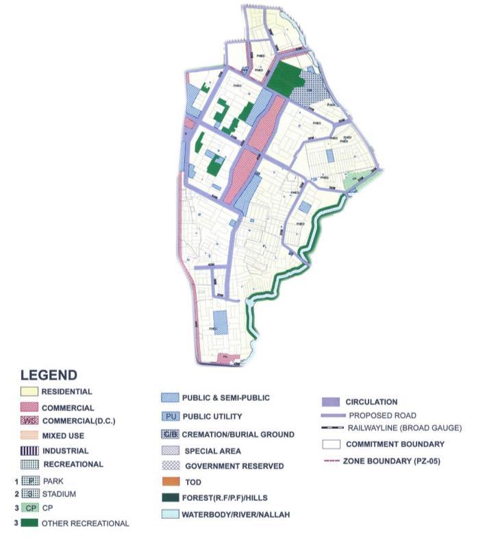
figure 1 land use of vidhyadhar nagar
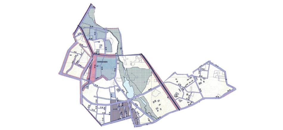
figure 2 land use of sanganer
International Research Journal of Engineering and Technology (IRJET) e-ISSN:2395-0056
Volume: 11 Issue: 07 | July 2024 www.irjet.net p-ISSN:2395-0072
ThereisnowasignificantamountofstudyontheeffectsofurbanFormontravelbehaviour. (Crane,1996)proposesthat developing a typology of the built environment's impact on travel could help incomprehension. According to Crane, researchinto`inameaningfulwayby:
Residentialandemploymentdevelopmentsthatarecompactanddense.
Reasonfortravel(journey-to-work,shopping,tripchaining,etc.)
Theanalyticaltechnique(simulations,regressions,etc.)
Explanatoryvariables(travelprices,travelopportunities,etc.)
Socioeconomicfactors,forexample.)
Thedata'snatureandamountofdetail
The following typology is based on Crane's late suggestion. This Form of classification is ideal for the empirical method used in this study because it provides a straightforward framework for finding and understanding the relationship between the many components of a study (meta-analysis), Travel behaviour and the built environment (independent variables).
Many communities and different cities use and employed this method and get a good result is an attempt to reduce the negative social, economic, and environmental impacts of urban sprawl over the last two decades. These planning approaches might be summarised as an effort to refocus peripheral development toward patterns reminiscent of preWorld War II American towns. The Neo-Traditional, New Urbanism, and Transit-Oriented Development (TOD) approach usesthefollowingcoredesignstrategies:
Awiderangeofactivitiesandlodgingalternatives
Aconcentrationofhomesandjobsaroundtransitterminalsandbusinessareas.
Attheneighbourhoodscale,smallerbuildings,blocks,androadwaysaredesigned.
Highly connected roadways (grid plan), sidewalks, and paths allow motorized and non-motorized modes of transportationtotravelrelativelydirectly.
Awell-definedcentrecontainedopenspace,publicbuildings, andretailestablishments.
International Research Journal of Engineering and Technology (IRJET) e-ISSN:2395-0056
Volume: 11 Issue: 07 | July 2024 www.irjet.net p-ISSN:2395-0072
DATABASE ANDMETHODOLOGY
Background Study
Identification of Problem
Aim and Objectives
Literature Review
Findings
Theory and Concepts
Data Collection
Analysis
Study the existing scenario of the system
Primary Survey
Secondary survey
Findings
Recommendation & Conclusions
Original data was collected directly from individuals via a questionnaire for research purposes. This approach provided directoversightofdatacollectionmethods,ensuringthatrelevantinformationalignedwithstudyobjectiveswasgathered systematically. The survey was conducted in two neighborhoods: Vidyadhar Nagar, with 71 respondents, and Sanganer, with 76 respondents. This primary survey methodology facilitated the acquisition of specific insights into the demographics, behaviors,andpreferencesof residents ineacharea,crucial for conductingdetailedanalysisanddrawing informedconclusionsrelatedtothestudy'sfocusonurbanformandtravelbehavior.
Weconductedcorrelationandregressionanalysesonthedatagatheredfromourprimarysurveytoexplorerelationships betweenurbanformvariablesandtravelbehavior.Initially,correlationanalysiswasperformedtoassessthestrengthand direction of relationships between variables. This step helped identify any significant correlations that could indicate potentialdependenciesorinfluencesbetweenaspectsofurbanformandtravelbehavior.
International Research Journal of Engineering and Technology (IRJET) e-ISSN:2395-0056
Volume: 11 Issue: 07 | July 2024 www.irjet.net p-ISSN:2395-0072
Following correlation analysis, regression analysis was employed to determine the statistical significance and predictive power of these relationships. Regression models were used to establish whether the observed correlations could be validatedandtoquantifytheextenttowhichurbanformvariablespredictvariationsintravelbehavioroutcomes.
By integrating these analytical methods, we aimed to provide a robust understanding of how specific elements of urban designimpacttravelpatterns.Thesefindingscontributevaluableinsightsforurbanplannersandpolicymakersseekingto developstrategiesthatpromotesustainableandefficienttransportationsystemswithincitieslikeJaipur.
Followingvariableweretakenastravelbehaviousaspects-
Safety: Safety concerns affect travel decisions significantly. Safe neighborhoods and well-lit streets encourage walking and cycling, while high crime areas may deter pedestrians and cyclists, leading to increased reliance on motorizedtransport.
Travel Cost: The cost of travel, including fuel, public transport fares, and parking fees, influences mode choice. Highercostsforcarusemayencouragepeopletooptforpublictransportornon-motorizedmodes,especiallyin citieswithgoodtransportinfrastructure.
Reliability:Reliabletransportationservices,suchaspunctualbusesortrains,reduceuncertaintyandencourage theiruse.Unreliableservicescanleadtoincreasedcaruseduetotheperceivedreliabilityofpersonalvehicles.
Walkability: Cities designed with pedestrian-friendly infrastructure, such as sidewalks, crosswalks, and pedestriansignals,promotewalkingasaprimarymodeoftransportforshorttrips.
Bicycle Friendliness: Infrastructure like dedicated bike lanes, bike-sharing systems, and secure bike parking facilitiesencouragecyclingasamodeoftransportation,particularlyforshorttomediumdistances.
Road Infrastructure: Well-maintained roads and efficient traffic management systems reduce congestion and traveltimes,impactingbothprivateandpublictransportusage.
Recreational/Open Spaces: Access to parks and recreational areas encourages active travel behaviors like walkingorcyclingforleisure,contributingtooverallphysicalandmentalwell-being.
Commercial Areas: Proximity to commercial centers influences travel patterns, with people often choosing to walkorusepublictransportforshoppingandleisureactivitieswithintheseareas.
Traffic:Congestedroadnetworkscandiscouragecaruseandpromotealternativemodeslikepublictransportor cycling,dependingontheavailabilityandreliabilityoftheseoptions.
Correlation
Vidyadhar Nagar
Table 1 CorrelationbetweenthedifferentvariablesofurbanformandtravelbehaviourinVidyadhar
Volume: 11 Issue: 07 | July 2024 www.irjet.net
Sanganer
Table 2 CorrelationbetweenthedifferentvariablesofurbanformandtravelbehaviourinSanganer
A positive correlation is a relationship between two variables that tend to move in the same direction. A positive correlationexistswhenonevariabletendstodecreaseastheothervariabledecreases.
Thereisastrongcorrelationbetweenthehighlightedvariables.Soregressionisdoneonthehighlightedvariables.
Regression
5.2.1 Regression between Road infra and Walkability, Vidyadhar Nagar SUMMARYOUTPUT
Table 0-1 RegressionbetweentheRoadinfraandwalkabilityinVidyadharNagar
International Research Journal of Engineering and Technology (IRJET) e-ISSN:2395-0056
Volume: 11 Issue: 07 | July 2024 www.irjet.net
p-value - .192
p-valueofthisregressionisgreaterthan0.05.Therefore,itisnotstatisticallysignificant.
Regression between Road infra and Open/Recreation spaces Vidyadhar Nagar
SUMMARY OUTPUT
Regression Statistics
Multiple R 0.166
R Square 0.027
Adjusted
Table 0-2 RegressionbetweentheRoadinfraandopen/recreationalspacesinVidyadharNagar
p-value - .462
The p-valueofthisregressionisgreaterthan0.05,sothesevariablesdonothaveastatisticallysignificantcorrelation.
Regression between Reliability and Traffic, Vidyadhar Nagar
SUMMARY OUTPUT
Regression Statistics
Multiple R 0.625
R Square 0.390
Adjusted R Square 0.360
Standard
Volume: 11 Issue: 07 | July 2024 www.irjet.net
p-value - .002
2395-0072
Table 0-3 Regressionbetweenthereliabilityandtraffic inVidyadharNagar
The p-valueofthisregressionismuchlessthan0.05,sothesevariableshaveastatisticallysignificantcorrelation.
Regression between Walkability and Open/Recreation spaces, Sanganer
SUMMARY OUTPUT
Regression
p-value - .001
Table 0-4 Regressionbetweenthewalkabilityandopen/recreationalspaces,Sanganer
The p-valueofthisregressionismuchlessthan0.05,sothesevariableshaveastatisticallysignificantcorrelation.
Regression between Traffic and Commercial Spaces, Sanganer
SUMMARY OUTPUT
Regression Statistics
Multiple R 0.412 R
International Research Journal of Engineering and Technology (IRJET) e-ISSN:2395-0056
Volume: 11 Issue: 07 | July 2024 www.irjet.net p-ISSN:2395-0072
Error Observations 22
Table 0-5 RegressionbetweentheTrafficandCommercialSpaces,Sanganer p-value - .056
The p-valueofthisregressionisgreaterthan0.05,sothesevariablesdonothaveastatisticallysignificantcorrelation.
The survey conducted in Vidyadhar Nagar reveals that a majority, 57.4%, of residents commute to work using cars, traveling an average distance of 6.42 km. Additionally, 28.8% of respondents use bicycles for recreational activities, covering an average distance of 0.62 km. Walking is a common mode of transport, averaging 18.9 minutes per trip. Car commutersinVidyadharNagarspendanaverageofRs.33.6onfuel forwork commutes,whiletwo-wheelerusersspend Rs.10.2.
In contrast, Sanganer shows different travel patterns, with 36% using two-wheelers for work commutes, covering an average distance of 4.05 km. For recreational activities, 16% use bicycles, averaging 0.80 km per trip. Walking averages 12.5minutes.FuelcostsforcarcommutersinSanganeramounttoRs.26.8,whiletwo-wheelerusersspendRs.17.5.These findings highlight distinct transportation preferences and behaviours between the planned development of Vidyadhar NagarandtheorganicgrowthofSanganerinJaipur.
Also, correlation and regression analysis were done among various variables in order find the relation between those variables.travelbehaviouraspectssuchasSafety,wlakbility,roadinfrastructure,traffic,openspaces,bicycleuseetcwere usedforthedataanalysis.Theanalysiswasdoneforbothselectedstudyareasrespectively.
From primary survey findings, neighborhoods with organic growth like Sanganer face higher traffic and less efficient circulation compared to planned developments like Vidyadhar Nagar, where traffic is lower. Residents in planned areas expresshighersatisfactionwithroadinfrastructure.Trafficconditionscanincreasewalkability,promotinglesscaruseon narrowerroadsundercertaincircumstances.
Allen,A.(2003).Environmentalplanningandmanagementoftheperi-urban
Cambridge Systematics, Inc. (1994), The Effects of Land Use and Travel Demand Management Strategies on CommutingBehavior.
CerveroR.andGorhamR.(1995),CommutinginTransitVersusAutomobileNeighborhoods.
Cervero,R.(2013).Linkingurbantransportandlanduseindevelopingcountries.
International Research Journal of Engineering and Technology (IRJET) e-ISSN:2395-0056
Volume: 11 Issue: 07 | July 2024 www.irjet.net p-ISSN:2395-0072
Crane, Randall. 1996. Cars and Drivers in the New Suburbs: Linking Access to Travel in Neotraditional Planning. JournaloftheAmericanPlanningAssociation
DouglasG.(1991),PlanningontheFringe:TheImpactofLandUseStrategiesonCongestion.
dynamicperi-urbanarea:acasestudyofHyderabad,India,
EwingR.,HaliyurP.andPageG.W.(1994)GettingAroundaTraditionalCity,aSuburbanPlannedUnitDevelopment, andEverythinginBetween.
Frank L. D. and Pivo G. (1994) Impacts of Mixed Use and Density on Utilization of Three Modes of Travel: Single OccupantVehicle,Transit,andWalking.
interface:Perspectivesonanemergingfield.
JaipurDevelopmentAuthority,ComprehensiveMobilityPlanJaipur2010
JournalofTransportandLandUse(JTLU)
Katz,Peter.1994.TheNewUrbanism:TowardanArchitectureofCommunity.NewYork:McGraw–Hill.
Lund,Hollie.2003.TestingtheClaimsofNewUrbanism:LocalAccess,PedestrianTravel,andNeighboringBehaviors. JournaloftheAmericanPlanningAssociation
Masterdevelopmentplan2025Jaipur
McNallyM.G.andRyanS.(1994)ComparativeAssessmentofTravelCharacteristicsforNeo-traditionalDesigns.
MdTanvirRahmanChowdhury,March,(2019)Changeintravelbehaviourina
Schneider, J. B. and Beck J. R. (1973) Reducing the Travel Requirements of the American City: An Investigation of AlternativeUrbanSpatialStructure.