
International Research Journal of Engineering and Technology (IRJET) e-ISSN: 2395-0056
Volume: 11 Issue: 07 | July 2024 www.irjet.net p-ISSN: 2395-0072

International Research Journal of Engineering and Technology (IRJET) e-ISSN: 2395-0056
Volume: 11 Issue: 07 | July 2024 www.irjet.net p-ISSN: 2395-0072
aYonas Kebede Beyene , Liu Ying a *
aTongji University, UNEP Institute of Environment for Sustainable Development (IESD): College of Environmental Science and Engineering, Shanghai 200092, P. R. China.
Abstract
Ecosystems directly or indirectly provide materials and energies to human, as well as numerous ecosystem services, such as air purification and climate adjustment. Urban development has greatly affected the ecosystem, but green space in urban area still has a certain ecological service function, which plays a role in alleviating urban air pollution, water shortage, urban heat island and other problems. In recent years, in the urbanization of Addis Ababa, the capital of Ethiopia, more and more attention has been paid to the construction of urban green space, but there are very few reports on the evaluation of ecological service value for urban green space. To this end, this study explores the potential effects of ecosystem services-oriented urban green space planning and design in Addis Ababa, Ethiopia, and quantifies the economic value of ecosystem services provided by urban green space, in order to provide data and support for the ongoing eco-friendly urbanization in Addis Ababa, Ethiopia.
Through satellite image interpretation, literature analysis and field investigation, Landsat data and measurable indicators were used to classify land cover, analyze land use change in Addis Ababa from 2013 to 2023, and assess landscape dynamics and ecosystem service value within urban green Spaces. Driven by factors such as population growth, infrastructure needs and economic activity, resulting in rapid urban development, a reduction in crop and grassland area, and an increase in built-up and bare land area, the study results show that the green area of Addis Ababa has declined from 44.8 percent in 2013 to 15 percent in 2023. The annual monetary value of ecosystem services has declined significantly, from $146.3 million in 2013 to $97.6 million in 2023, below the criteria recommended by the World Health Organization, with the potential for significant loss of ecosystem service functions in the short term. Air filtering value decreased from 145,685.16 USD in 2013 to 34,446.12 USD in 2023, The microclimate regulation value has declined from $588,051.00 in 2013 to $420,132.00 in 2023. The noise reduction value has declined from $1,460,898.00 in 2013 to $1,043,736.00 in 2023. Rainwater drainage regulating value was 685,882.00 USD in 2013 but decreased to 497,511.00 USD in 2023. The sewage treatment value has declined from $2,267,395.00 in 2013 to $1,277,846.00 in 2023. The recreation and cultural value has also declined from $966,914.00 in 2013 to $565,244.00 in 2023. Due to a decrease in tourism, a loss of cultural heritage, and a decline in the quality of life for residents. It is important to take steps to conserve and restore Addis Ababa's green spaces to protect the city's natural and cultural resources and improve the quality of life for its residents.
Therefore, the study emphasizes the need for immediate action to prevent further loss of ecosystem services, and calls for concerted efforts by all parties, including government departments, relevant stakeholders and environmental organizations, to conserve biodiversity through landscape restoration and management, improve air and water quality, and promote recreational activities. In addition, city managers should prioritize maintaining adequate green space, balancing regulation and recreation services, listening to citizens, improving green space management systems, and using high-resolution data for accurate land cover mapping and ecosystem service valuation. Policymakers should incorporate the value of urban ecosystem services into green space planning and development to maximize the benefits of urban ecosystems and build resilient and ecologically healthy cities.
Keywords: UrbanGreenSpaces,MonetaryValue,Landsatdata,ecologicalconservation
1.Introduction
Urbangreenspacesplayacrucialroleinmeetingecologicalconservationandenvironmentalprotectionneeds[1].Greenspaces actasthelungsofurbanareas,preservinglifewithinthebuilt-upenvironmen.UGSoffersessentialecosystemservicessuchas enhancing air quality, removing pollution and reducing noise, conserving water and soil, regulating microclimates, and mitigatingurbanheatislands[2]-[3]
International Research Journal of Engineering and Technology (IRJET) e-ISSN: 2395-0056
Volume: 11 Issue: 07 | July 2024 www.irjet.net p-ISSN: 2395-0072
However, these services are often undervalued and overlooked in economic decision-making. This is particularly true in rapidly growing cities like Addis Ababa, where the demand for urban green space is increasing, and the pressure on the naturalenvironmentismounting.ThestudyaimedtoassessthelanduselandcoverchangesinAddisAbaba,Ethiopiainthree different epochs based on remotely sensed data gained from satellite images, and estimate the economic values of UGS to highlighttheconservationandrestorationofecosystemvaluesofurbangreenspaces.
AddisAbaba cityis experiencing rapid population growth withan increase in the densityof built spaces,housing expansion, space development, and restructuring of industrial areas. Greater population density in urban areas increases demand for greenareasbutcitiesarefacingadiminishingofgreenspaces[4]
AddisAbabagreenspacehasbeenconvertedtootherlandusetypes,pullingthesuggestedUNhealthorganizationstandards of green spaces per capita far lower than 20 square meter[5]. Unplanned urban growth, increased urbanization, and developmenthaveplacedurbangreenspacesunderextremepressure.
Valuing ecosystem services can help to determine whether a policy intervention that alters an ecosystem condition delivers net benefits to society; providing evidence on which to base decisions on ‘value for money’ and prioritizing funding; and choosingbetweencompetinguses.Thecaseforecosystemservicevaluesofurbangreenspacesisnotproperlyidentifiedwith adequateinformationbecauseofalackofcomprehensivestudiesonthevaluationofthemulti-functionsandservicesofUGSs. Thus,studiesonthevaluationofthemulti-functionsandservicesofUGSarenecessarytobeusedasabasefordecisionsand policydevelopmentonenvironmentalissues[6,7]
However, research has not yet been undertaken in Ethiopia in general and in the capital city Addis Ababa in particular. Therefore, related and specific studies are required in terms of their context. The goal of the current study is to fill this knowledge gap. The study intends to estimate the ecosystem service values of urban green spaces of Addis Ababa by using multi-temporal satellite image analysis underpinned by field surveys. The result may help decision makers to compare the environmental and developmental values and the allocation of the budget for the city UGS enhancement and management programs.
Addis Ababa green space has converted to other land use types, pulling the suggested UN health organization standards of greenspacespercapitafarlowerthan20squaremeters.Unplannedurbangrowth,increasedurbanization,anddevelopment haveplacedurbangreenspacesunderextremepressure.
ThisismainlybecauselackofknowledgeonthemultidimensionalvaluesofUGSforsocietyincludingtheenvironmentalpolicy makersandhenceabsenceofstrongnationalUGSpoliciesorstrategiesaretheotherfundamentalreasonsthataggravatethe depreciation of these resources. Unless restoration, enhancement, conservation, and management mechanisms for these ecosystemsareimplemented,theabovemultipleUGSbenefitswillbelostasaresult.
Valuing ecosystem services can help to determine whether a policy intervention that alters an ecosystem condition delivers net benefits to society; providing evidence on which to base decisions on ‘value for money’ and prioritizing funding; and choosingbetweencompetinguses.Thecaseforecosystemservicevaluesofurbangreenspacesisnotproperlyidentifiedwith adequateinformationbecauseofalackofcomprehensivestudiesonthevaluationofthemulti-functionsandservicesofUGSs. Thus,studiesonthevaluationofthemulti-functionsandservicesofUGSarenecessarytobeusedasabasefordecisionsand policydevelopmentonenvironmentalissues.However,researchhasnotyetbeenundertakeninEthiopiaingeneralandinthe capital city The result may help decision makers to compare the environmental and developmental values and on the allocation of budget for the city UGSs enhancement and management programs. Therefore, the result of the study provided insights into the need for and focus of future studies on LULC changes and the valuing of ESVs to understand the impact of changesinLULConESVsconsideringexistingandforecastedpopulationincreaseinrapidlyurbanizingareas.TheESVswere evaluated based on land cover classes. The ultimate goal is to develop a comprehensive understanding of the ecosystem services provided by urban green spaces and their value to society, which can inform policy and management decisions for sustainableurbandevelopment.
International Research Journal of Engineering and Technology (IRJET) e-ISSN: 2395-0056
Volume: 11 Issue: 07 | July 2024 www.irjet.net p-ISSN: 2395-0072
The primary goal of this investigation is to determine the monetary worth of the ecosystem services offered byurban green spaces in Addis Ababa, Ethiopia. Additionally, the study will analyze the alterations in the city's landscape through the utilization of a fragment analysis technique. The assessment will also concentrate on the incorporation of ecosystem service values into the planning and administration of urban green spaces within the city. Finally, valuable suggestions will be put forth to guarantee the long-term viability and improvement of the ecosystem service value of urban green spaces while maintainingcost-effectiveness.
Thevalueof ecosystemservicesprovidedbyurban greenspacesholdssignificanttheoretical implicationsforunderstanding their role in sustainable urban development. Quantifying the diverse benefits of green spaces could contribute to a comprehensiveunderstandingofecological,social,andeconomicurbansustainability.Thisinformationcaninformpolicyand management decisions related to urban planning, land use, and environmental conservation. It can also shed light on the factorsinfluencingtheprovisionanduseofurbangreenspaces,guidingfutureresearchon urbanecologyandenvironmental governance.
Theresultofthestudyprovidesaframeworkforunderstandingtheeconomicvalueofecosystemservices,enrichingeconomic theory by applying economic principles to natural resources and environmental conservation. It also aids in better resource allocation and decision-making by providing insights into the trade-offs involved in different land use options, thus helping policymakersmakeinformeddecisionsaboutconservationanddevelopment.
ThepracticalvaluesofestimatingecosystemservicevaluesofurbangreenspacesFirstly,thestudycanprovideabasisforthe developmentofstrategiestoenhancetheprovisionandmaintenanceofurbangreenspaces.Thiscanincludeidentifyingareas where additional green spaces are needed, as well as determining the types of green spaces that are most beneficial for the localcommunity.Secondly,thestudycanassistpolicymakersinmakinginformeddecisionsabouttheallocationofresources forurbanplanningandmanagement.
This can include decisions about land use, zoning, and the provision of public services. Thirdly, the study can inform the development of educational programs and outreach initiatives aimed at raising awareness about the importance of urban green spaces and their role in promoting sustainable urban development. Finally, the study can provide a framework for evaluatingtheeffectivenessofpoliciesandmanagementpractices.
2.Materials and Methods
2.1 Description of the Study Area
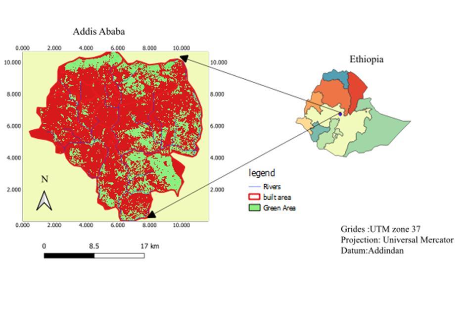
AddisAbabacity,whichisthecapitalofEthiopialocatedonthecoordinatebetween9°0′19.4436′′Nand38°45′48.9996′′E,at elevationsrangingfrom2015to3152metersabovesea level.ThetotalpopulationofAddisAbabain2023was5,228,000,at 4.43%increasefrom2021.Thecityishometoanestimated5.2millioninhabitantsandconstitutesapproximately20percent ofEthiopia’surbanpopulation[38].Itwasestablishedasanationseatin1886.Itisthemajorpoliticalandeconomiccenterof thecountry,aswellastheseatoftheAfricanUnion(AU).Itisdividedintoelevensub-citiesand121districts,calledWoreda. LanduseandlandcoverchangesincreasedthemeanlandsurfacetemperatureinAddisAbabacity,Ethiopia,by8.3°Coverthe last three decades. The extremely high temperatures in urban areas impose dangerous heat-related health issues on urban citizens.
The spatial distribution of the urban green showsthat seven major andsix medium rivers receive water flow from 75 small tributaries. The existing forest area is mostly found in the northern part, (which is also the highest altitudinal range), northwest,southwest,northeast,andwestpartofthecityorknownbythelocalnamesofEntoto,Yeka,Ankorcha,andGullele The major sitesof whichare mainly Koye, Wedesso, Idoro, Feche, Akakibeseka,Abeora, Dongora, Harbu, Jemo, Bulbula,Bole weregenu,DiremigraMekanissa,Lafto&peacok.
There are also eleven formal functional parks with total area coverage of 110 hectares; these are Ambassador, Hamle 19, BehereTsige,Peacock,Yeka,Ferensay,Sheger,Anbassagibi,GolaMichaeleandKolfeParks.
International Research Journal of Engineering and Technology (IRJET) e-ISSN: 2395-0056
Volume: 11 Issue: 07 | July 2024 www.irjet.net p-ISSN: 2395-0072
Altitudinal zones of Addis Ababa range from 2054 m to 3023-meter asl, situated in the foothills of the Entoto Mountains, spreadacrossmanywoodedhillsidesandgullies,cutthroughwithfast-flowingstreams.Atpresent,thecityisdividedinto11 sub-cities and 116 Woreda (administrative districts), with the total population of Addis Ababa is 3,775,348, which is about 60%ofthetotalurbanpopulationinEthiopia
The rainfall and the temperature conditions of these areas is described based on the data collected by the Ethiopian Meteorological Service Agency (EMSA) from Entoto station. According to the data from EMSA, the result of the analysis showed that the mean annual temperature of the study area is about 13.4 degree celucious. The range of mean monthly minimum and maximum temperatures of the study area is 7.5 degree celucious and 20.7 degree celucious in December and February,respectively.
The mean annual minimum and maximum temperature is 8.4 degree celucious and 18.4 degree celucious respectively. The hottestmonthin2023wasFebruarywithamaximumtemperatureof20.7degreecelucious,followedbyMarch(20.2degree celucious)andMay(20degreecelucious)andthecoldestmonthinthesameyearwasDecemberwithaminimumtemperature of7.5Co.Themeanannualrainfalloftheseareasis1215.4mmperyearandisbimodaltype.Themeanmonthlyminimumand maximum rainfall is 16.6 mm (January) and 278 mm (August), respectively. The short rainy season extends from March to MayandthelongrainyseasonstartsfromJulyandextendstoSeptember,butunexpectedshowersmayoccurinallmonthsof the year he city vegetation is mostly covered by exotic tree species like; Eucalyptus globules, Gravilla robusta, Phonix reclinata, Casuarina, Omedla, and Jacaranda, but the land closer to the river banks and inaccessible areas in the upper catchmentarecoveredbymorethan250trees,shrubs,herbs,climbers,fernsandotherplantspecies.It isdepictedintheFig. 1below
2.2
The data sources for this research were primarily collected from Landsat images. Secondary data was reviewed from the National Meteorology Agency of Ethiopia, the Central Statistical Agency, and the Addis Ababa Environmental Protection Authority.ThepopulationcensusdatawillbecollectedfromtheCentralStatisticalAgency.
As the source of thematic data, especially data on land cover characteristics and surface elevation remote sensing is the practiceofgatheringinformationaboutanobject,event, orarea using a device that does notmake physical contactwiththe target. This data is typically captured in the form of images, which can then be analyzed to extract temporal details and identifysurfacefeatures[8] .
TherearemorethanathousandactivesatellitesorbitingtheEarthandquiteanumberofsatelliteswiththeirsensorsusually acquire images of Earth's surface continually at different spatial resolutions, ranging from sub-meter to kilometers, and temporalresolutionsrangingfrom30minutestoweeksormonths[9] .
International Research Journal of Engineering and Technology (IRJET) e-ISSN: 2395-0056
Volume: 11 Issue: 07 | July 2024 www.irjet.net p-ISSN: 2395-0072
A geographic information system [10] is a computer-based tool that manages geospatial data, solves spatial problems and supports the collection, storage, transformation, analysis, retrieval, and display of data in an effective manner. It consists of hardware,software,andprocedurestoachievethesefunctions[11].GISandremotesensingtoolsareutilizedcollaborativelyto determine the location within the catchment area and to analyze the spatial connections between various physical characteristicsofthecatchment,includinglandcover,waterbodies,andvegetationcover[11]
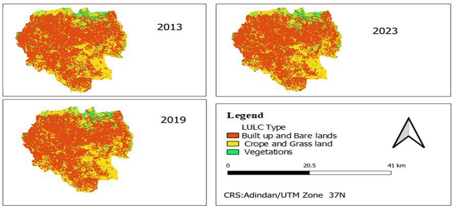
The remotely sensed data, Landsat 8 OLI (Operational Land Imager), by three different times 2013, 2019, and 2023. All the images were collected with archivehttps://ers.cr.usgs.gov/.The acquisition dates ofthe satelliteimages werecarried out in February 2023 because, this time in Addis Ababa, a dry season clear sky and we can properly discriminate the required information about the vegetation and distinguish it from other farmland and grassland. A semi-automatic Classification PlUGSn (CSP) in QGIS version 3.28 was used for further image processing and classification. For LULC classification and analysisallthereflectivebandswereused.
2.3
The data sources for this research primarily came from Landsat images. Secondary data will be collected from the National MeteorologyAgencyofEthiopia,theCentralStatisticalAgency,andtheAddisAbabaEnvironmentalProtectionAuthority.The populationcensusdatawillbecollectedfromtheCentralStatisticalAgency.
2.3.1
As the source of thematic data, especially data on land cover characteristics and surface elevation remote sensing is the practiceofgatheringinformationaboutanobject,event, orarea usinga device that does notmake physical contactwiththe target. This data is typically captured in the form of images, which can then be analyzed to extract temporal details and identify surface features [8]. There are more than a thousand active satellites orbiting the Earth and quite several satellites with their sensors usually acquire images of Earth's surface continually at different spatial resolutions, ranging from submeterstokilometers,andtemporalresolutionsrangingfrom30minutestoweeksormonths[12]
2.3.2
A geographic information system [10] is a computer-based tool that manages geospatial data, solves spatial problems, and supports the collection, storage, transformation, analysis, retrieval, and display of data in an effective manner. It consists of hardware,software,andprocedurestoachievethesefunctions [11].GISandremotesensingtoolsareutilizedcollaborativelyto determine the location within the catchment area and to analyze the spatial connections between various physical characteristicsofthecatchment,includinglandcover, waterbodies,andvegetationcover [11].Inaddition,remotesensing [13] andGISarenowprovidingeffectivetoolsforadvancedecosystemandsocio-economicmanagement[14] .
The remotely sensed data, Landsat 8 OLI (Operational Land Imager), by three different times 2013, 2019, and 2023. All the images were collected with archive https://ers.cr.usgs.gov/.The acquisition dates ofthe satelliteimages werecarried out in February 2023 because, this time in Addis Ababa, a dry season clear sky and we can properly discriminate the required information about the vegetation and distinguish it from other farmland and grassland. A semi-automatic Classification PlUGSn (CSP) in QGIS version 3.28 was used for further image processing and classification. For LULC classification and analysisallthereflectivebandswereused.
Scientistshavedevelopedtoolsetstomeasurevaluessuchasasenseofplaceandtraditionalecologicalknowledge.Inanurban context,theintegratedassessmentmethodisstronglyrecommendedtoencompassthetotalcomplexityofecosystemservice valuesofurbangreenspaces[15].Differentvaluesandperceptionsshouldbeconsideredtomakewell-informeddecisionsinthe management of urban ecosystem services. [16] The choice of which specific values should be assessed and articulated in the processes of urban planning depends on the characteristics of the urban ecosystem services that are being valued in the institutional,socioculturalcontextsinwhichdecisionsaretakenplace.
Volume: 11 Issue: 07 | July 2024 www.irjet.net
Hedonic pricing methods are used to determine the value of cultural UESs, such as the esthetic of green areas. A major difficulty in the application of hedonic methods is the limitation to the assessment of use values, such as those provided by culturalservicesandsomeregulatingservices,dependingonthescale.Hedonicmethodsrequirelargedatasetsandcomplex methods of data analysis. Another monetary valuation approach is contingent valuation[17] To obtain socio-cultural values, methods are needed that often demand the use of holistic approaches that may include qualitative measures, constructed scales,andnarrationInsomecases,translatingthesevaluesintoquantitativemetricsisdifficultorsenseless.
However, in practice, their focus tends to be too narrow to encompass the total complexity of socio-ecological systems The integrated assessment of monetary values in an urban context is strongly needed.[18] Researchers are developing and validating Ecosystem Services indicators at various scales, allowing for a comprehensive assessment of Urban Ecosystem Servicesconditions,trends,andchanges.,[19]]UnderstandingthefactorsinfluencingUrbanEcosystemServicesrequirestheuse ofinterconnectedindicatorsthatmonitortheinteractionbetweensocial-ecologicaldynamicsandecosystempressures.
nother aspect of the valuation process was the Contingent Valuation Method based on the amount that households were willing to pay for the restoration of the rivers. Furthermore, the study also assessed the recreational value of Parks, a significanturbangreenspaceinAddisAbaba.ByemployingtheTravelCostMethod,theresearchersestimatedthevaluethat residents derived from visiting the park. This emphasizes the importance of preserving and enhancing the Park as a recreational asset, promoting the well-being and quality of life for the city's inhabitants. According to this scheme, the total valueofecosystemserviceisequaltotheproductsoftheareascoveredbythecorrespondingserviceandtheestimatedvalue inUSdollars
3.1 Spatial distribution of UGS in Addis Ababa
Agricultural land occupied 16,219 hectares (30.0%), while Natural Vegetation covered 2,637 hectares (4.88%). Wetlands spanned2,885hectares(5.34%),andopenlandaccountedfor1,373hectares(2.54%)in2013.By2019,the distributionhad changed, with agricultural land decreasing to 13,860 hectares (25.63%) and 11,391 hectares (21.07%) by 2023. Natural vegetation shrank to 1,955 hectares (3.62%) in 2019 and to 1,884 hectares (3.48%) in 2023. Wetlands decreased to 1,647 hectares (3.05%) and to 1,513 hectares (2.80%) in 2023. Open land was reduced to 1,599 hectares (2.96%) by 2019 and to 1,239hectares(2.29%)by2023.
Table3Landcoversclassareacoverageandpercentage
LandCoverAreainThreeEpochs
Landcoverclasstype
International Research Journal of Engineering and Technology (IRJET) e-ISSN: 2395-0056
Volume: 11 Issue: 07 | July 2024 www.irjet.net p-ISSN: 2395-0072
Land-use/coverdynamicsareamajorcomponentoflanddegradation,whichaffectsoverallecosystemservices.Thisisakey factorbehindacceleratedsoilloss,increasedsedimentyields,andreducedprotectionagainsterosion[20].Inthestudyarea,the changeinlandcoverisaffectingthelandscape'sdominanceandcomposition.Asthepatchareaischanging,thecorresponding ecosystemservicesandtheirestimatedvalueareaffectedaswell.
The most prominent landscape change in Addis Ababa from 2013 to 2023 was the conversion of cropland to other land-use types; the process of land-cover change was more intense from 2013 to 2019 than from 2019 to 2023 The high agricultural intensity in cropland areas impacted class connectivity compared to other patch mosaics in the study area. The study found thatthedecreaseinUGSclassareasaffectedtheestimatedvalueofecosystemservices.
Atthelandscapelevel,theNPofbuilt-upandbarelandhasdecreasedfrom6448in2013to5216patchesin2023.Itappears that Addis Ababa City experienced intensive assimilation after 2013 due to the dominance of built-up pockets in the urban fringeandperipheralareas.PDremainconstantfrom2013to2023withvaluesof3.17patchesper100hectares.AhighLPI valueisfoundforagriculturedecreasingfrom67.8%in2013to46.31%in2023). Regardinglandscapeconfiguration,theAI wasmorethan80%atthelandscapelevelwithanincrementaldecreasefrom68.2%in2013and66.4%in2023.
International Research Journal of Engineering and Technology (IRJET) e-ISSN: 2395-0056
Volume: 11 Issue: 07 | July 2024 www.irjet.net p-ISSN: 2395-0072
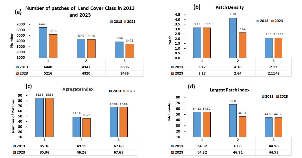
Figure2.3Landscapecompositionindicesfrom2013to2023
The main challenges lie in the vast variation of landscape composition, scale dependency, and in the spatial distribution of ecosystem provisioninglandcovertypesand benefittinghumanpopulation.Supportingservicese.g.consideredlesslocation dependent as their services are not directly enjoyed by humans in the vicinity, i.e. pollination of crops can occur anywhere, whilethecropscanbeconsumedanywhereelseontheglobe.
Urbangreenspaces(UGS) thatcompriseforests,pastures,residentialyards,parks,grassylawns,andengineeredgreenroofs and rain gardens provide multiple ecosystem services to humans and the environment[21] , [22]. The ecosystem services provided by these UGS, including environmental services (e.g., reducing elevated urban heat, pollution, flood mitigation, and offsetting greenhouse gas emissions), ecological services (e.g., providing habitats for urban wildlife and biodiversity conservation),andsocialandhumanhealthbenefits[23]
The results of the study on land cover dynamics in Addis Ababa from 2013 to 2023 reveal significant changes in ecosystem servicevalues(ESV)fordifferentlandcovertypes.ThedatashowsaconcerningtrendofdecreasingESVforurbanecosystem services(UGS)inAddisAbaba.In2013,theestimatedvalueofUGSwas146.3millionUSDperyear,butthisvaluedecreasedto 115 million USD in 2019 and further declined to 97.6 million USD per year in 2023. This downward trend in UGS values indicatespotentialdegradationorlossofurbanecosystemservicesovertheyears,whichcouldhavenegativeimpactsonthe city'senvironmentandresidents.
On the other hand, the expansion of built-up areas in Addis Ababa is evident from the data. Built-up areas increased from 30,953hectaresin 2013 withanESV of 206.2 million USDto 35,006 hectares in 2019withanESV of233.2 millionUSD and further grew to 38,040 hectares with an ESV of 253.4 million USD by 2023. This expansion of built-up areas signifies urban developmentandinfrastructuregrowthinAddisAbaba,whichmayhavecontributedtothedeclineinUGSvaluesduetoland
Volume: 11 Issue: 07 | July 2024 www.irjet.net
transformation and habitat loss. The relentless expansion of built-up areas encroaches upon green spaces. High population densityexacerbatesthescarcityofUGS.WeakenforcementofdevelopmentplansandpolicieshindersUGSpreservation.Lack ofPriority:InsufficientemphasisonUGSdevelopmentcontributestoitsdegradation.
Addis Ababa city’s residents face inadequate access to recreational UGS. Between 2013 and 2023, the land use for UGS in AddisAbabadecreasedby13..11%.Urbanagriculturesawasignificantdeclineof9.9%,followedbyurbanforestsat1.4%. Thepercapitaparkareastandsatamere0.37squaremeters,farbelowtheEthiopianUGSstandardsof15squaremeters. Shockingly,over90%ofthepopulationlacksaccesstoexistingparkswithintheminimumwalkingdistancethresholds.In 2013, the land cover of Addis Ababa was composed of built-up and bare lands or non-green spaces covering 30,953 hectaresor57.25percentofthetotalarea,andgreenspacescovering23,114hectaresor42.75percentofthetotalareain 2013.ThedetailrevealedinTable3below
Table32ComparingAreacoverageofGreenandnon-greenspaceinThreeEparches Land Cover
threeEpochs
3.5 Spatial pattern and influence factor analysis of ESV of Urban Green Spaces
Inthisstudy,theservicesandbenefitsgainedfromecosystemswerefirstinventoriedbyreferringtotheecosystemservices Classified land cover classes were converted into ecosystems and each of the predefined ecosystems was assigned to its perceived services and benefits. The valuation of ES consisted of estimating the approximate monetary values in US dollars usingtheupdatedvaluationscheme[24]
, six economic services (air filtering, microclimate regulation, noise reduction, rainwater drainage, sewage treatment, and culturalservicesarecalculatedbasedonfielddataandstandardvaluesperhectareperyearinUSD.Thedetailisdepicted in thetablebelow.
Localconservativecoefcients($ha−1year−1),adoptedfromKinduetal.(2016) International Research Journal of
Table3.3EstimatedValuesofEcosystemServiceValuesofAddisAbaba2013to2023
International Research Journal of Engineering and Technology (IRJET) e-ISSN: 2395-0056
Volume: 11 Issue: 07 | July 2024 www.irjet.net
The data on ecosystem service functions for Forest, Grassland, and Water bodies reveals significant contributions to various aspectsoftheenvironment.IntermsofGasorAirQualityRegulation,Forestsprovideavalueof13.68,Grasslandscontribute 7, and Water bodies offer 45,685.16 units. The total value in 2013 for this service was 34,446.12 units. Micro Climate Regulation is primarily driven by Forests with a value of 223, while Water bodies significantly contribute 588,051.00 units. NoiseReductionservicesaresubstantial,withForestsproviding554unitsandWaterbodiescontributing1,460,898.00units. Erosion Control and Rainwater Drainage services see Forests with a value of 245 and Grasslands with 29 units in 2013. SewageTreatmentisavitalservice,withForestsandGrasslandseachproviding87units,whileWaterbodiescontribute665 units.Lastly,Recreation&Cultureservicesarevaluedat114forForests,2forGrasslands,and230forWaterbodiesin2013. Thetotalvaluesfortheseservicesin2023arenotavailableforcomparison
Air pollution ecosystem health, crops, climate, visibility, and man-made materials. Health effects related to air pollution includeimpactsonpulmonary,cardiac,vascular,andneurologicalsystems[25].Thereductionisprimarilycausedbyvegetation filtering pollution and particulates from the air[26]. The ability of trees to intercept pollution varies between species, throughout the age of the tree, and with the planting design[27]. Trees can lower air temperatures, potentially decreasing emissionsfrom human activities[28]. Treesrelease different amountsofvolatile organiccompounds[29] [30].Sulfideand nitride arepresentintheair,attheintersectionofabsorptionrangeandplantresistance[31,32]
Theestimatedecosystemservicevalueassociatedwithairqualitypromotionprovidedbyurbangreenspacesdecreasedfrom 145,685.16USDin2013to 34,446.12USDin2023,indicatinga substantial decline. Thisdeclinein theair qualitypromotion valueofurbangreenspacescanbeattributedtovariousfactorssuchasurbanization,pollution,climatechange,andlanduse changes.Ascitiesgrowandexpand,greenspacesmaybelostordegraded,reducing theirabilitytomitigateairpollutionand improve air quality. Additionally, increased pollution levels and changing environmental conditions can also impact the effectivenessofurbangreenspacesinprovidingtheseecosystemservices.
AirQualityRegulation ValuesofGreenSpacesofAddisAbabain 2013and2023


in USD
Air Quality Regulatory Service Value
3.5.2 Quantitative assessment on micro-climate regulation of UGS
Citytreescanlowerthesummertemperaturesofthecitymarkedly[37].Onelargetreecantranspire450litersofwaterper day and this consumes 1000 MJ of heat energy to drive the evaporation process. City trees can also lower the summer temperatures of the city markedly[38]. It is widely established that UGS could reduce local UHI levels while UGI-associated
International Research Journal of Engineering and Technology (IRJET) e-ISSN: 2395-0056
Volume: 11 Issue: 07 | July 2024 www.irjet.net
vegetation has been shown to increase evapotranspiration and shading and reduce radiation, absorption, and the amount of heatstoredwithinurbansurfaces[33,34]
In the study, a replacement cost method (RCM) was deployed to evaluate the climate regulation benefit provided by UGS withinthetargetarea.TheRCMlooksatthecostofreplacingadamagedorlostassetandusesthiscostasapartialproxy or measureofitsvalue [35] , [36] ThedeclineinthemicroclimateregulationvalueofAddisAbaba'sforestsisconcerning,as itcould leadtoseveralnegativeconsequences,suchasincreasedairpollution,highertemperatures,andmorefrequentheatwaves.It is important to take steps to conserve and restore Addis Ababa's forests to protect the city's microclimate and improve the qualityoflifeforitsresidents.Thisindicatesadeclineintheclimateregulationbenefitsprovidedbyurbangreenspaces inthe cityduringthistimeframe.
ClimateRegulationValueofGreenSpacesofAddisAbabain2013and2023
Regulation Value
3.5.3
Sounds propagate long distances on water[37]. The distance to the source of the noise is one major factor when doubling the distance decreases the equivalent level by 3 dB. The other key factor is the character of the ground for instance a soft lawn, ratherthanaconcretepavement,decreasesthelevelbyanother3dB.[38] .
Theexistingliteratureaddressesthefunctionofvegetationintheabsorptionandinsulationofnoise,whileurbangreeninghas a certain commonality when it comes to noise attenuation[39]. The value of the noise reduction provided by UGS is directly relatedtotheperformanceofanygivenforestonitsown[50,85].Wethususedtheafforestationcostmethodtoevaluatethe ESvalueofnoisereduction.Tobeclear,theafforestationcostmethodreferstotheconstructioncostoftheforestarea,which canreduceanequalamountofnoiseenoughtoreplacethevaluesofother(morecostly)meansofurbannoisereduction[40] .
Currently, the afforestation method isa widelyused approachto estimate thevalue of forest ecosystems at theaxisof noise reduction is based on a 15% afforestation cost[40,42]. Afforestation cost is determined by the average afforestation cost multipliedbythevolumeofmatureforestperunitarea,andtotalforestarea.AccordingtotheEnvironmentProtectionBureau of Addis Ababa, the average afforestation cost is approximately USD Cost of afforestation per USD 19,045.57/hectare. The estimatednoisereductionvalueofAddisAbabawas1,460,898in2013anditreached1,043,736USDin2023.
International Research Journal of Engineering and Technology (IRJET) e-ISSN: 2395-0056
Volume: 11 Issue: 07 | July 2024 www.irjet.net p-ISSN: 2395-0072
Forests play a crucial role in reducing noise pollution. They act as sound barriers, absorbing and scattering sound waves. Forestsalsohelptoreducewindspeeds,whichcanfurtherreducenoiselevels.ThenoisereductionvalueofAddisAbabaCity greenspacesderivedfromforestshasdeclinedfrom$1,460,898.00in2013to$1,043,736.00in2023.Thisdeclineislikelydue toadecreaseintheareaofforestcoverinAddisAbaba.
The decline in the noise reduction value of Addis Ababa City green spaces is concerning, as it could lead to a number of negative consequences, such as increased noise pollution, sleep disturbance, and stress. It is important to take steps to conserveandrestoreAddisAbaba'sforestsinordertoprotectthecity'snoiseenvironmentandimprovethequalityoflifefor itsresidents.
3.5.4 Quantitative assessment of rainwater drainage
Reduction Value of Green Spaces ofAddisAbaba in 2013 and 2023
Reduction Value
Reduction Value
RainwaterdrainageecosystemservicesrefertothenaturalprocessesandfunctionsManageandregulatetheflowofrainwater withinecosystems,reducingtheriskofflooding,erosion,andwater pollution.15%oftherainwaterrunsofftheground,with therestevaporatingorinfiltratingtheground.Invegetation-freecities,about60%oftherainwaterisinsteadledoffthrough storm-waterdrains(1997,D.B.Botkin`,a.C.E.`, #122).
Existing researchhasaddressedUGS'scontributionto watermanagement effortsthroughrunoff preventionandstormwater recapturetofacilitatefloodingwhererainandnaturalearthfiltrationoccur both ofwhichalsobenefitgroundwatersupply and water reuse for activities such as landscaping[41]. To achieve this, the cost of the flood control project per year was annualized via the amortization of the capital cost to arrive at an annual value for water control and conservation benefits. Thus,SPMisalsoanimplicitformofmarketprice,definedasthemarginalpricethatsocietyinvestsonthenon-marketedES through the construction of these projects[42,43]. Scholars have already addressed its applicability for assessing the value of watercontrolandstorage[44,45]
WethusperformedanSPManalysistoassessthevalueofwatercontrolandconservationpertheESprovidedbyUGS.Perthe Ethiopian Water and Energy Bureau, the average annual precipitation in the flood season in Addis Ababa is 547.5 mm. The nationalfloodcontrolprojectconstructioninvestmentisestimatedtocostUSD0.67per1m3ofstoragecapacity[46].Theareas ofwetland,water,andforestareregardedastheprimaryUGSforwatercontrol.
Forests and wetlands play a crucial role in regulating rainwater drainage. Forests help to slow down the flow of rainwater, which reduces the risk of flooding. Wetlands act as natural sponges, absorbing and storing rainwater. The decline in the rainwater drainage regulation value of Addis Ababa's green spaces is concerning, as it could lead to several negative consequences, such as increased flooding, water pollution, and damage to infrastructure. It is important to take steps to conserve and restore Addis Ababa's green spaces to protect the city's water resources and improve the quality of life for its residents.Thedataprovidedindicatesadecreaseintherainwaterdrainagevalueofthestudy
International Research Journal of Engineering and Technology (IRJET) e-ISSN: 2395-0056
Volume: 11 Issue: 07 | July 2024 www.irjet.net p-ISSN: 2395-0072
3.5.5 Quantitative assessment of Sewage treatment
RainWaterDrainage ReductionValue
Sewage treatment ecosystem services refer to the natural processes and functions that help remove contaminants and pollutants from wastewater, improving water quality and safeguarding human health and the environment. Up to 96% of the nitrogen and 97% of the phosphorous can be retained in wetlands, and so far wetland restorations have largely been successful,increasingbiodiversityandsubstantiallyloweringcostsofsewagetreatment[47]
AddisAbabahasnofunctionalsewagetreatmentplant.Thecityhasveryfewnaturalwetlandsavailableforsewagetreatment, but it is possible to construct more wetlands for cleaning sewage water. Up to 96% of the nitrogen and 97% of the phosphorouscanberetainedinwetlands,andsofarwetlandrestorationshavelargelybeensuccessful,increasingbiodiversity andsubstantiallyloweringcostsofsewagetreatment.[46]
Forests and wetlands play a crucial role in treating sewage. Forests help to filter and remove pollutants from water, while wetlandsprovideanaturalhabitatforbacteriathatbreakdownorganicmatter.ThesewagetreatmentvalueofAddisAbaba's greenspaceshasdeclinedfrom$2,267,395.00in2013to$1,277,846.00in2023.Thisdeclineislikelyduetoadecreaseinthe area of green spaces in Addis Ababa, particularly forests and wetlands. Sewage treatment of Addis Ababa's green spaces is concerning, as it could lead to several negative consequences, such as increased water pollution, disease outbreaks, and damagetoaquaticecosystems.
It is important to take steps to conserve nd restore Addis Ababa's green spaces to protect the city's water resources and improve the quality of life for its residents.This decline could be attributed to various factors, including increased urbanization, population growth, inadequate infrastructure maintenance, and lack of investment in wastewater treatment facilities. As urban areas expand and populations increase, the demand for sewage treatment services also rises, putting pressureonexistingsystemsandleadingtopotentialdegradationofwaterqualityandecosystems.
International Research Journal of Engineering and Technology (IRJET)
Volume: 11 Issue: 07 | July 2024 www.irjet.net
Sewage Treatment Value of Green Spaces of Addis Ababa in 2013 and 2023 Sewage Treatment Value
9,89,549.00
12,77,846.00
Total Value 2013
22,67,395.00
-0056
3.5.6 Quantitative assessment of Recreational and cultural values
Recreation is essential to achieving the quality of life to make it possible for people to live a reasonable life within an urban environment[48] Culturalservices(CES)providedbyUGSarelargelydeterminedbypeople’ssubjectiveperceptionsandneeds andsignificantlyaffectthe
Improvementofhumanwell-beingperphysicalandmentalhealthandspiritualculture[24] .
The study addresses the Recreational Value of Entoto Park. The study employed the Travel Cost Method to estimate the recreational valueof the park based on visitordata. Thefield estimation of48,924,400USD fortherecreational andcultural ecosystemHowever,it'simportanttonotethatthefieldestimationoftherecreationalandculturalecosystemservicevalue of thecityissignificantlyhigherat48,924,400USD.
This suggests that the global standard may not fully capture the true value of these ecosystem services as perceived by residentsandvisitors. The discrepancybetween theGlobal standardandthefield estimationhighlightsthe needto consider local perspectives and values when assessing ecosystem services. It also underscores the importance of engaging with local communitiestounderstandtheirrelationshipwithrecreationalandculturalamenities,andtoincorporatetheseperspectives intodecision-makingprocesses.
ItisservicevalueofAddisAbabaindicatesthattheseservicesplayasubstantialroleincontributingtotheoverallwell-being and quality of life in the city. As such, policymakers and urban planners need to recognize and protect these valuable ecosystem services through sustainable land use planning, conservation efforts, and community engagement. By acknowledgingthehigherlocalestimationoftherecreationalandculturalecosystemservicevalue,AddisAbabacanprioritize investments in preserving and enhancing these amenities, thereby promoting a healthier and more vibrant urban environmentforitsresidentsandvisitors
International Research Journal of Engineering and Technology (IRJET)
Volume: 11 Issue: 07 | July 2024
RecreationandCulturalValueofGreenSpacesofAddisAbabain2013and2023


and Cultural Value
4.1 Spatial pattern and influence factor analysis of ESV of Urban Green Spaces
The area covered by built-up and bare lands (30,953 hectares) has consistently increased from 57.255% in 2013 to 38,040 hectaresofcoverageor 70.36% of the total land cover in 2023. This indicates rapid urban development and expansion of infrastructurein thecity,leadingto theconversionof natural andagricultural landsinto built-upareas.Conversely,thearea occupiedbygreenspacesdecreasedovertheyears,from42.75%in2013to29.64%in2023.Thisdeclinesuggestsareduction in agricultural and natural land cover, potentially due to urban encroachment and conversion of these areas for other purposes.
TheresultsindicateasignificantshifttowardsurbanizationanddevelopmentinAddisAbaba,leadingtochangesinlandcover distribution and potential implications for biodiversity, ecosystem services, and overall environmental sustainability in the city. Monitoring and managing these land use changes are essential to ensure sustainable development and conservation of naturalresourcesinAddisAbaba
Thedecreaseinvegetation,crop,andwetlandclassareasaffectedtheestimatedvalueoftheecosystemservicesaswell.High AIincropandgrasslandclasseswitnessestheclass'sconnectivitycomparedtootherpatchmosaicsinthestudyarea.Itwas remarked that deriving ecosystem services for the very same pixel can be subject to errors. The use of similar spatial resolution data as inputs in estimating the value of ecosystem services results in significantly similar estimates of the total value. High-resolution data, like 1m resolution are believed to enhance the correctness of the final land cover map which is subsequentlyusedforcomputinglandscapemetricsandecosystemservicesvaluation.
International Research Journal of Engineering and Technology (IRJET) e-ISSN: 2395-0056
Volume: 11 Issue: 07 | July 2024 www.irjet.net p-ISSN: 2395-0072
The study provides insights into the economic worth and significance of the city's natural assets. By the value of ecosystem services, policymakers and stakeholders can make informed decisions about sustainable urban planning and development. The valuation process involves assessing the various ecosystem services provided by urban green spaces, and quantifying theireconomiccontributionstothecityanditsresidents.
Thedatarevealsaconcerningtrendofasignificantdecreaseintheairqualitypromotionvalueofurbangreen spacesinAddis Ababa City from2013to 2023.To addressthisissue, policymakersand urbanplannersmust prioritize the preservationand enhancementofurbangreenspaces,implementsustainablelandusepractices,andadopteffectivepollutioncontrolmeasures. Effortstoprotectandpromotegreeninfrastructurewillbeessentialinimprovingairquality,enhancingurbanlivability,and safeguardingthehealthandwell-beingofcityresidents.
Understanding the drivers behind the fluctuations in open/grassland cover and ecosystem service value is essential for effectiveconservationandmanagementstrategies.Itiscrucialtoidentifyandaddressthefactorscontributingtothedeclinein open grasslands to ensure the continued provision of ecosystem services and benefits associated with these valuable ecosystems.Conservationefforts,restorationinitiatives,sustainablelandusepractices,andcommunityengagementcanplaya vitalroleinsafeguardingopengrasslandsandpromotingtheirecologicalresilienceandlong-termsustainability
Theopen/grasslandcoverfrom2013to2023showsafluctuatingtrend.In2013,therewere1,373hectaresofopen/grassland with an ecosystem service value (ESV) of 5.7 million USD. By 2019, the area increased to 1,599 hectares with an ESV of 6.7 millionUSD,indicating positiveconservation efforts.However, by2023,theareadecreasedto1,239hectareswithanESVof 5.2millionUSD,signalingpotentialthreatstoopengrasslands.Understandingthedriversbehindthesefluctuationsiscrucial for effective conservation strategies to ensure the continued provision of ecosystem services and benefits associated with opengrasslands.
TheecosystemservicevaluesforAddisAbabahaveundergonesignificantchangesbetween2013and2023.Severalecosystem serviceshaveexperiencedadeclineinvalue,whileothershaveremainedrelativelystableorevenincreased.
The information regarding ecosystem service functions for Forest, Grassland, and Water bodies underscores the crucial role these ecosystems play in providing essential services that contribute to the overall well-being of the environment. Notably, Water bodies stand out as the most significant contributor to Gas or Air Quality Regulation, with a value of 45,685.16 units, highlighting their crucial role in maintaining air quality. Forests also play a substantial role in this service, with a value of 13.68units.
The decline inthe air qualitypromotion value of urban green spaces isattributed tourbanization, pollution,climate change, andlandusechanges.Ascitiesexpand,greenspacesmaybelostordegraded,leadingtoareductionintheirabilitytomitigate airpollutionandimproveairquality.Additionally,increasedpollutionlevelsandchangingenvironmentalconditionsmayalso impact the effectiveness of urban green spaces in providing these ecosystem services. This decrease underscores the importance of monitoring and evaluating the ecosystem service value of green spaces over time and the need for proactive measures to protect and enhance these valuable resources to ensure they continue to provide essential benefits for urban residentsandtheenvironment.
In terms of Micro Climate Regulation, Forests lead in providing this service with a value of 223 units, showcasing their importanceinregulatinglocalclimateconditions.Waterbodiesalsomakeasignificantcontributionwithavalueof588,051.00 units. The decrease in the Climate Regulation Value of Green Spaces in Addis Ababa City from 2013 to 2023 is a concerning trend that highlights the potential impact on the city's environment and inhabitants. The decline from 588,051.00 USD to 420,132.00 USD represents a significant reduction of 167,919.00 USD over the ten-year period. This decrease indicates a
International Research Journal of Engineering and Technology (IRJET) e-ISSN: 2395-0056
Volume: 11 Issue: 07 | July 2024 www.irjet.net p-ISSN: 2395-0072
potential loss of benefits such as absorbing carbon dioxide, releasing oxygen, providing shade, reducing urban heat island effect, and improving air quality. It is essential for city planners and policymakers to prioritize the preservation and enhancementofgreenspacesinAddisAbabatoensurethatthecitycontinuestobenefitfromtheirclimateregulationservices.
Regarding Noise Reduction, Water bodies emerge as the primary contributor to noise reduction services with a value of 1,460,898.00 units, indicating their role in reducing environmental noise pollution. Forests also play a notable role in noise reduction with a value of 554 units. The estimated noise value of Addis Ababa refers to the economic cost associated with noise pollutioninthe city. Thedecrease in the estimatednoisevalue from 1,460,898USD in 2013 to 1,043,736 USDin 2023 indicatesareductionintheeconomicimpactofnoisepollutionoverthedecade.Thisreductionisattributedtovariousfactors including improved urban planning, implementation of noise control measures, and advancements in technology leading to quieter infrastructure and transportation. It is important to note that noise pollution can have significant adverse effects on humanhealth,includinghearingimpairment,sleepdisturbance,stress,andreducedproductivity.
5. Conclusions and Recommendations
5.1 Conclusions
The study aimed to analyze changes in land use in Addis Ababa over three time periods using remote sensing data from satelliteimages.ItsoughttoemphasizetheeconomicvalueofUrbanGreenSpaces(UGS)andtheneedtoconserveandrestore urban ecosystem values. The research revealed a troubling decrease in green spaces in Addis Ababa, with 7,087 hectares convertedfromgreentonon-greenspaces.ThisdeclineraisesconcernsaboutfallingbelowtheUNHOrecommendedstandard by-9.58%,potentiallyresultinginacompletelossofecosystemserviceswithinapproximatelyfiveyears.
Urban ecosystems are crucial for providing essential services such as clean air, water, and food, but their value is often overlookedineconomicdecision-makingprocesses,particularlyinrapidlyexpandingcitieslikeAddisAbaba.Thestudyfound that the total stock value of ecosystem services of urban green spaces in Addis Ababa was around $97.6 million in 2023, equivalent to 0.008 percent of Ethiopia's GDP. This information could be valuable for informed decision-making and encouragingwillingnesstopaytopreserveecosystemintegrity.
TheresearchhighlightedasignificanttrendofurbanizationandlandusetransformationinAddisAbabaoverthepastdecade, withanincreaseinbuilt-upandbarelandsattheexpenseofcropandgrasslandareas.Thisrapidurbandevelopmentislikely driven by factors such as population growth, infrastructure needs, and economic activities. The study underscored the importance of evaluating land-use changes to measure the values of ecosystem services and ensure urban sustainability for futurepolicyplanninganddecision-making.Thefindingscanserveasastartingpointforpolicyselectionandplanningbythe cityadministrationtoshapeasustainablecity.
Recognizing the economic value of urban green spaces can help city officials, urban planners, and stakeholders prioritize sustainablelandmanagementpracticesandensurethepreservationandenhancementofthesenaturalassets.Integratingthe valuationofurbanecosystemservicesintogreeninfrastructureplanninganddevelopmentinitiativesiscrucialforharnessing the benefits of urban ecosystems while creating resilient and ecologically sound cities. The study also noted that the spatial resolutionoftheimagecouldimpactthefinalclassifiedlandcovermapandderivedecosystemservices.Usinghigh-resolution datawasconsideredtoenhancetheaccuracyofthefinallandcovermapusedforcomputinglandscapemetricsandecosystem servicesvaluation
The city administration should utilize this report as a foundational step in policy selection and planning for creating a sustainable urban environment. However, further in-depth studies are necessary, leveraging high-resolution imagery and increased ground control samples to minimize errors and enhance confidence levels in the data. Integrating the valuation of urban ecosystem services into green space planning and development initiatives is crucial for decision-makers to maximize thebenefitsofurbanecosystemsandfosterresilientandecologicallysoundcities.Thevaluationofurbanecosystemservices in Addis Ababa shall serve as a cornerstone for informed decision-making and sustainable urban development, emphasizing theeconomicvalueofgreenspacestoprioritizesustainablelandmanagementpractices.
International Research Journal of Engineering and Technology (IRJET) e-ISSN: 2395-0056
Volume: 11 Issue: 07 | July 2024 www.irjet.net p-ISSN: 2395-0072
Maintainingadequategreenspaceswithinlimitedareas,balancingregulatingandrecreationalservices,incorporatingcitizen input into green space planning, and implementing improved green space management systems are essential. Improving spatial resolution, particularly through the use of high-resolution data like 1m resolution, is critical for accurate land cover mappingand ecosystemservicesvaluation. Translating researchfindings intoactionable recommendations for policymakers andstakeholdersisessentialforeffectiveresourceallocationandinformeddecision-makingonurbanecosystemconservation and development. Further studies with high-resolution imagery and increased ground control samples can help minimize errorsandincreaseconfidencelevelsinthedata.
Byimplementingstrategiesthatleverageecosystemservicevaluestoenhancethequalityofgreenspaces,suchasmaintaining sufficient green spaces, balancing vegetation structure types, incorporating citizen considerations, and improving spatial resolution, cities can thrive as models for sustainable urban development. Prioritizing high-resolution data, such as 1m resolution,canenhancetheaccuracyoflandcovermapsandcontributetomorereliablecalculationsoflandscapemetricsand ecosystemservicesvaluation.
References
[1] XUZ,ZHAOS.Scaledependenceofurbangreenspacecoolingefficiency:AcasestudyinBeijingmetropolitanarea[J]. SciTotalEnviron,2023,898:165563.
[2] HAQSMA.Urbangreenspacesandanintegrativeapproachtosustainableenvironment[J].JournalofEnvironmental Protection,2011,Vol.2.
[3] PITMAN M E A S. Green Infrastructure Life support for human habitats; the compelling evidence for incorporating natureintourbanenvironments[J].2013.
[4] DUBBALE DANIEL A. T J. Urban Environmental Challenges in Developing Cities: The Case of Ethiopian Capital Addis Ababa[J].sl:InternationalScholarlyandScientificResearch&Innovation,2010,164.
[5] WONDIMU A. Which urban livelihood without adequate breathing space? A reflection on the green areas of Addis Ababa.[Z].GreenForumConference.AddisAbaba.2007
[6] SAMSONA.AssessmentofurbangreenspacesinAddisAbaba[J].2014.
[7] LAYKE C. Measuring nature's benefits: A preliminary roadmap for improving ecosystem service indicators. Washington,DC:[J].WorldResourcesInstitute,.
[8] AMEGAH A K, YEBOAH K, OWUSU V, et al. Socio-demographic and neighbourhood factors influencing urban green spaceuseanddevelopmentathome:Apopulation-basedsurveyinAccra,Ghana[J].PLoSOne,2023,18(6):e0286332.
[9] Y. HUANG Z X C, T. YU, X. ZHI HUANG, AND X. FA GU,:. “Agricultural remote sensing big data: Management and applications,”[J].JournalofIntegrativeAgriculture,,2018,17(9):1915–31.
[10] GISSELQUIST R. Good Governance as a Concept, and Why This Matters for Development Policy. [J]. Helsinki: UNWIDER,2012.
[11] D. AMETA. Integration of remote sensing data with Geographic Information System (GIS): Applications and change detection techniques [J]. International Journal of Managing Public Sector Information and Communication Technologies,,2015,6(4).
[12] HAN J, HAYASHI, Y., CAO, X., & IMURA, H.,. Evaluating land-use change in rapidly urbanizing China: Case study of Shanghai[J].JournalofUrbanPlanningandDevelopment,,2009,135(4)::p.166-71.
[13] COSTANZAR,DEGROOT,R.,SUTTON,P.,VANDERPLOEG,S.,ANDERSON,S.J.,KUBISZEWSKI,I.,ETAL.,.Changesinthe globalvalueofecosystemservices.s.l.:Glob.Environ.Change[J].2014,Vol.26.:p.152-8.
International Research Journal of Engineering and Technology (IRJET) e-ISSN: 2395-0056
Volume: 11 Issue: 07 | July 2024 www.irjet.net p-ISSN: 2395-0072
[14] MILCU A, HANSPACH, J., ABSON, D. & FISCHER, J. Cultural ecosystem services: a literature review and prospects for futureresearch[J].2013,18.
[15] HAN J, HAYASHI, Y., CAO, X., & IMURA, H.,. Evaluating land-use change in rapidly urbanizing China: Case study of Shanghai.[J].JournalofUrbanPlanningandDevelopment,2009,135(4)::p.166-71.
[16] AFRICAUNEASCECF.ConferenceofAfricanMinistersofFinance,PlanningandEconomicDevelopment/[R].Addis Ababa,Ethiopia,2008.
[17] 1. TONG C, R. FEAGIN, J. LU, X. ZHANG, X. ZHU, W. WANG, AND W. H.. Wenzhou, :, , ., ,. Ecosystem service values and restorationintheurbanSanyangwetlandofWenzhou,China[J].2007,.Vol.29:p.249-58.
[18] LIEKENS I, SCHAAFSMA M., STAES, J., DE NOCKER, L., BROUWER, R., MEIRE, P. , AFDELING MILIEU-,. Economische waarderingvanecosysteemdiensten,eenhandleiding.StudieinopdrachtvanLNE[J].2010.
[19] PARK S E A. Structural defects in the regulatory particle-core particle interface of the proteasome induce a novel proteasomestressresponse.[J].(2011)286(42):(36652-66).
[20] WOLDEMARIAM G.W. H A E. Effect of land use and land cover change on soil erosion in Erer Sub-basin, northeast Wabi-Shebellebasin,Ethiopia.[J].Land2020,9,:111.
[21] RALL L, NIEMELA, J., PAULEIT, S., PINTAR, M., LAFORTEZZA, R., SANTOS, A., ZELEZNIKAR, S.,. A typology of urban greenspaces,eco-systemservicesprovisioningservicesanddemands.[J].2015.
[22] M.F.ARONSONC.A.LEPCZYKKLE,M.A.GODDARD,S.B.LERMAN,J.S.MACIVOR,C.H.NILON,T.VARGO.Biodiversityin thecity:keychallengesforurbangreenspacemanagementFront[J].2017,15:pp.189-96
[23] C.D. IVES P E L, C.G. THRELFALL, K. IKIN, D.F. SHANAHAN, G.E. GARRARD, S.A. BEKESSY, R.A. FULLER, L. MUMAW, L. RAYNER,R.ROWE.Citiesarehotspotsforthreatenedspecies[J].2016:pp.117-26.
[24] BOARD.MEA.EcosystemsandHumanWell-Being,A,.Miller,[J].2005,5thed.:pp.10–1.
[25] POPE C A, BURNETT, R.T., THUN, M.J., CALLE, E.E., KREWSKI, D., ITO, K., THURSTON, G.D.,. Lung cancer, cardiopulmonarymortality,andlong-termexposuretofineparticulateairpollution.[J].2002,287(9)(1132e1141).
[26] SVENSSON M A E I. Gro¨nstrukturens betydelse for stadens ventilation (The importance of green areas for the ventilationofthecity).[J].1997.
[27] PITMAN M E A S. Green Infrastructure Life support for human habitats; the compelling evidence for incorporating natureintourbanenvironments.[J].2013.
[28] C. A. C, W. L. . “Natural hydrocarbons, urbanization, and urban ozone.” [J]. Journal of Geophysical Research, , (1990), 95(D9),:13971–912.
[29] CHAMEIDES W L, LINDSAY, R. W., RICHARDSON, J., & KIANG, C. S. The role of biogenic hydrocarbons in urban photochemicalsmog:Atlantaasacasestudy.Science,[J].(1990).24(1):(4868),14731.
[30] HODANJA,&BARNARD,W.R.AirpollutionremovalbyurbanforestsinCanadaanditseffectonairqualityandhuman health.[J].JournalArticle23,(2004)..
[31] YIN S, SHEN Z,ZHOU P, et al.Quantifyingair pollutionattenuation within urbanparks:An experimental approachin Shanghai,China.[J].2011,159:2155–63..
[32] WUJ,YOUY.PreliminaryAssessmentofEcosystem ServicesValueofPearlRiverDeltaGreenwayLineOne.China.[J]. 2017,33:98–103.
International Research Journal of Engineering and Technology (IRJET) e-ISSN: 2395-0056
Volume: 11 Issue: 07 | July 2024 www.irjet.net p-ISSN: 2395-0072
[33] KNAPP S, JAGANMOHAN M, SCHWARZ N. Climate regulation by diverse urban green spaces: Risks and opportunities relatedtoclimateandlandusechange.InAtlasEcosystemServices;[J].2019;:pp.167–72.
[34] MONTEIRO M V, DOICK K J, HANDLEY P, et al. The impact of greenspace size on the extent of local nocturnal air temperaturecoolinginLondon.UrbanFor.[J].2016,,16,:160–9.
[35] PAULEIT S, LIU L, AHERN J K, A. Multifunctional green infrastructure planning to promote ecological services in the city.InUrbanEcology.Patterns,Processes,andApplications;[J].2011:272–85.
[36] SEELANDK,DUBENDORFER,S.,HANSMANN,R.,.MakingfriendsinZurich’surbanforestsand parks:theroleofpublic greenspaceforsocialinclusionofyouthsfromdifferentcultures.[J].2009.,11,(10–17).
[37] KOMMUNFO¨RBUNDET. Sko¨nheten och oljudet (The Beauty and the noise). [M]. Swedin, Stokholm: Trafikbuller skydd,SvenskaKommunfo¨rbundet,,1998.
[38] NATURVARDSVERKET.Guidefor varderingavekosystemtjanster[J].2015,91(620-669 ).
[39] FRANCIS C D, KLEIST N, ORTEGA C P, et al. Noise pollution alters ecological services: Enhanced pollination and disruptedseeddispersal.[J].2012,279:2727–35.
[40] PENG.J,WANGY,CHEN Y,etal.EconomicValueofUrbanEcosystemServices:ACaseStudyinShenzhen.[J].2005,4: 594–604.
[41] LIUL,FRYDO,ZHANGS.Blue-GreenInfrastructureforSustainableUrbanStormwaterManagement LessonsfromSix Municipality-LedPilotProjectsinBeijingandCopenhagen.[J].2019,11:2024.
[42] LIT,GAOXJW.EcosystemservicesvaluationoflakesidewetlandparkbesideChaohuLakeinChina.[J].2016,8,:301.
[43] HARRISONPA,DUNFORDR,BARTONDN,etal.Selectingmethodsforecosystemserviceassessment:Adecisiontree approach.[J].201.
[44] SAARONIH,AMORIMJH,HIEMSTRAA,etal.UrbanGreenInfrastructureasatoolforurbanheatmitigation:Surveyof researchmethodologiesandfindingsacrossdifferentclimaticregions.[J]..2018,24:94–110.
[45] HEWITTCN,ASHWORTHK,MACKENZIEA.Usinggreeninfrastructuretoimproveurbanairquality(GI4AQ).[J].2020, 49:62–73.
[46] EWEL K C. Water quality improvement by wetlands. In: Daily, G.C. (Ed.), Natures Services. Societal Dependence on NaturalEcosystems.[J].1997.,(pp.329–344.).
[47] EWELKC,.WaterqualityimprovementbywetlandsIn:Daily,G.C.(Ed.),[M].1997.
[48] D. B. BOTKIN A C E. Beveridgeo Cities as environments [M]. Washington, D.C: American, George Mason University 1997
Iwouldliketoexpressmyheartfeltgratitudetoallthosewhosupportedmeduringthecompletionofmymaster'sthesis.First and foremost, I am deeply thankful to my supervisor, Professor Liu Ying, from the University of Tongi University. His guidance, patience, and unwavering support were instrumental in bringing this research to fruition. His insightful direction, motivational advice, and engaging discussions have not only enhanced my research skills but have also laid a strong foundationformyfutureacademicendeavors.Hisastutefeedbackandvaluablesuggestionshavesignificantlycontributedto theimprovementandsuccessfulcompletionofmythesis.
Ialsoextend myappreciationto the staffof theEnvironmental Protection Officein AddisAbaba,Ethiopia,fortheirkindness andassistancethroughoutmystudies.Theirsupporthasbeeninvaluableinshapingmyresearchjourney.
International Research Journal of Engineering and Technology (IRJET) e-ISSN: 2395-0056
Volume: 11 Issue: 07 | July 2024 www.irjet.net p-ISSN: 2395-0072
Finally, but most importantly, I would like to thank my spouse Yeshework Shiferawe, my Daughter Dawit my brother Jemal Mihamede.itwouldbeanunderstatementtosaythat,asafamily,wehaveexperiencedsomeupsanddownsinmylife.Every time I was ready to quit, you did not let me and I am forever grateful. This research stands as a testament to your unconditional loveandencouragement.Thank youall forsupportingandguiding metowhereIamtoday.MaytheAlmighty Godcontinuetoblessyouall!