
International Research Journal of Engineering and Technology (IRJET) e-ISSN:2395-0056
Volume: 11 Issue: 08 | Aug 2024 www.irjet.net p-ISSN:2395-0072

International Research Journal of Engineering and Technology (IRJET) e-ISSN:2395-0056
Volume: 11 Issue: 08 | Aug 2024 www.irjet.net p-ISSN:2395-0072
Aziha M 1 , Dr. Jasmine J.C Sheeja, M.E., Ph.D., 2
1PG Student, Dept. of Electronics And Communication, Rohini College of Engineering and Technology, Kanniyakumari Tamil Nadu, India
2Professor, Dept. of Electronics And Communication, Rohini College of Engineering and Technology, Kanniyakumari, Tamil Nadu, India.
Abstract The acquisition of satellite images with the highest resolutions is not possible because of the current optical satellites' technical limitations as well as their limited budgets. In existing framework, produce items with high ghastly (HS) and fleeting goals, presented a twostream otherworldly worldly combination method in view of consideration component called STA-Net. Because of the intricate attention mechanisms that are used both spatially and temporally, STA-Nets frequently necessitate a significant amount of computational power. This project proposes a detection algorithm based on ship structure and the local binary pattern (LBP) descriptor to overcome the shortcomings. Due to cluttered scenes and varying ship sizes, ship detection from optical satellite imagery is difficult. Present a novel saliency segmentation framework that allows for the flexible integration of multiple visual cues to extract candidate regions from various sea surfaces. This is important for a variety of applications, including illegal smuggling, traffic surveillance, fishery management, and so on. Then, straightforward shape analysis is used to get rid of clearly false targets. Finally, true ship targets are distinguished using a structure-LBP feature that identifies ships' inherent topology structure. Multiple panchromatic satellite image results confirm that the proposed method outperforms other current methods in terms of detection time and accuracy.
Key Words: Hyperspectral image, Local Binary Pattern (LBP), Saliency Segmentation, Shape Analysis.
For a wide range of applications, such as traffic surveillance, fishery management, and illegal smuggling, remotesensingimagery'sabilitytoidentifyshipsiscrucial. Because they are little affected by weather and time, synthetic aperture radar (SAR) images play an important role in detecting and tracing targets in previous research.
However, high-level speckles are common in SAR images, they are insensitive to wood, and they are difficult for humans to interpret. Optical satellite images have a higher resolution and contain more detailed information than SAR and other types of remote sensing images; Consequently, theyarebettersuitedfortargetrecognitionordetection.
YuanYao Anetal.[1]proposedInthefieldofremotesensing, ship target detection in optical images has received increasing attention.Optical remotesensingimages' shiptargetdetection technology is susceptible to numerous factors, whereas real dataaredifficulttocontain.Togetthedifferentcircumstancesin thehugeoceanscenes,wefosterareproductionframeworkfor high-goalopticalremotedetectingpictureofboattargets.
XiaoyangXieetal.[2]proposedShipdistributionprobability analysis enables rapid ship detection from optical satellite images.Itisstilldifficulttodetectshipsautomaticallyusing optical satellite images. By analyzing the ship distribution probability, this paper proposes a novel method for ship detection from optical satellites. The sea cluster histogram modelisusedtofirstconstructananomalydetectionmodel; The ship candidates are then identified by examining the ship distribution in light of the ship safety navigational criterion, and the area properties of the ship candidates remove obvious non-ship objects; Lastly, a ship candidate's structural continuity descriptor is intended to eliminate falsealarms.
Shuchen Wang et al. [3] proposed The Saliency Adjusted Deep Network for Optical Satellite Image Ship Detection a Saliency Adjusted YOLO (SA-YOLO) for optical satellite imageshipdetectionisdeveloped.First,duetothefactthat the ship in low resolution imagery can be regarded as a salient object, they designed a saliency guided dense sampling layer (SDSL) to improve the spatial sampling of small ship targets. Secondly, the saliency region-aware convolution (SAConv) strategy is designed to improve the representationcapabilityofsalientregionsandincreasethe attention of network to these regions. Sergey Voinov et al.
International Research Journal of Engineering and Technology (IRJET) e-ISSN:2395-0056
Volume: 11 Issue: 08 | Aug 2024 www.irjet.net
[4]proposedDetectionofMulticlassVessels.Withaspatial resolution of up to 0.3 meters per pixel, a growing constellationofveryhighresolution(VHR)opticalsatellite sensors can frequently cover large areas, allowing for the identification and differentiation of various vessel types. With the help of principle component analysis (PCA) and deep convolutional neural networks (DCNN), a novel approach to automatic multiclass vessel detection is presentedinthispaper.
Yin Zhuang et al. [5] proposed ship detection based on Multi-Orientation Sparse Representation. They proposed a multi-orientations sparse dictionaries (MOSDs) algorithm combining with comprehensive structure voting (CSV) to address existed problem and achieve refined docked ship contourregionproposal(RP).
Guang Yang et al. [6] designed Ship Detection Using Sea Surface Analysis from Optical Satellite Images To address this issue, they propose a novel sea surface analysis-based detection technique. Using two brand-new features, the proposed method first determines whether or not the sea surface is homogeneous. After that, ship candidates are chosen using a novel linear function that combines pixel andregioncharacteristics.Tofinallyeliminatefalsealarms, compactnessandlength-to-widthratioareutilized.
Yiqun He et al. [7] designed Without Sea-Land Segmentation,ShipDetectionInthecontextofapplications in remote sensing, ship detection is a significant and challenging issue. Sea-land segmentation is typically required prior to ship detection, according to current literature. The methods' implementation becomes extremely difficult as a result of this. This paper therefore proposes a ship detection method for large-scale images based on Faster R-CNN that does not require sea-land segmentationasa preprocessingstepandcandetectships directly from a complex background that includes both landandsea.
Yu-Hui Ma et al. [8] proposed Multi-Scale Salient-Region Detection for Optical Remote Sensing Images. In this method, they first use hypercomplex Fourier transform to get the amplitude matrix and phase matrix of the image and then use wavelet transform to calculate six saliency images of different scales in the frequency domain. And then use the evaluation function to select two best multiscale saliency maps to generate the final saliency map by adaptiveweightcombination.Finally,thethresholdisused to process the enhanced saliency map to locate the ship target.
p-ISSN:2395-0072
MesutKartaletal.[9]proposeddeeplearningtechniquefor ship detection. An open-source, fast-running ship detection system based on optical satellite images and the deep learning algorithm was proposed in this paper. The framework needn't bother with any thorough equipment, even can chip away at a typical PC. Tensorflow Article Identification Application Programming Connection point (API)isprepared byoptical satellitepictures withships and utilizedasitemrecognitionProgramminginterface.
Chunbo Zhu et al. [10] proposed Segmentation of Ship InstancesUsingCross-DomainTransferThesampletransfer moduleandtheknowledgetransfermoduleoftheproposed method simulate images from optics to SAR and use simulation images to pre-train the instance segmentation network's ship detection component. We also make a ResPyramid network to make sure that the deep network can stillextractusefulfeaturesfromSARimages.

Contextual analysis

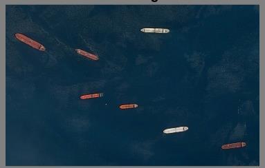
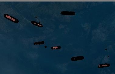
Testing image


International Research Journal of Engineering and Technology (IRJET) e-ISSN:2395-0056
Volume: 11 Issue: 08 | Aug 2024 www.irjet.net p-ISSN:2395-0072
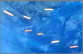
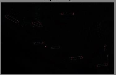
In order to find candidate regions for a subsequent classifier, this paper develops a novel saliency segmentation framework that allows for the flexible integration of multiple visual cues. Second, this letter is the first to, to our knowledge, incorporate intensity distinctness,patterndistinctness,andcontextualanalysis into the ship detection procedure from optical satellite images. Regardless of the detection scene's variations, the combination of these three image cues results in a high detection rate. Third, we propose a construction neighborhood parallel example (LBP). feature that applies ship bodies' inherent topology structure by combining spatial information with local features to produceamorediscriminativeshipdescription.
Panchromatic satellite images from Google Earth with a 2-m spatial resolution were used in the experiments, which involved two data sets: a testing data set and a training data set for the patch. The classifier is trained with the help of the patch training data set. It contains trainingsamplesintotal,eachofwhichmeasures40x40 pixels. Positive samples are divided into eight classes according to the various target orientations because the structure-LBPfeatureissensitivetoorientation.Inorder to find ships in various orientations, we made eight classifiersthatcorrespondedtotheeightclasses.
Ships have much lower intensity frequencies in panchromaticsatelliteimagesthanthebackgroundofthe sea because sea water makes up the majority of the sea surface. Additionally, ships' intensity distribution typically differs from the background of the sea surface. Consequently, we use the gray statistics of the input image to define the intensity distinctness values for image pixels using a histogram-based contrast method.Specifically, the intensity distinctness value of a pixel intheinputimageIisdefinedasfollows, ( ) ∑ ( ) (1)
where is the intensity value of pixel , n is the numberofdifferentpixelintensities, istheprobability of pixel intensity in image I, and D( , ) is the Euclideandistancebetween and
Influenced by the sensor attributes and enlightenment, transport powers are in some cases very like the forces of different sorts of messiness in pictures. As a result, in situations like these, the cue of intensity distinctness alone is insufficient to locate targets. We apply a pattern distinctness measure based on the phase spectrum of a Fourier transform to the distinct patterns of ships, also known as the boundary between an object and its background. This measure can be used to identify areas of theimagethathaveadistinctappearance.
Although intensity and pattern distinctness have the potential to significantly aid in the identification of ship candidates in input images, their efficacy varies depending onthescene.Tomeasuretheeffectivenessofthesetwocues on different scenes, we analyze context and define an importantindex,calledthe“surfaceregularindex,”whichis calculatedasfollows:
wherenisthenumberofdifferentpixelintensities,andfiis the probability of pixel intensity gi . A larger r (r ∈ (0, 1)) implies that the scene is more homogeneous; in other words, the target intensities are relatively similar to the background. Increased homogeneity weakens the effectiveness of the intensity distinctness cue for ship candidateselection. Asa result,thepatterndistinctness cue has more discriminative power than the intensity distinctness cue and should be given more weight in the distinctness measure. A smaller r value, on the other hand, indicates that the intensity distinctness cue ought to be emphasizedwhenselectingshipcandidates.
International Research Journal of Engineering and Technology (IRJET) e-ISSN:2395-0056
Volume: 11 Issue: 08 | Aug 2024 www.irjet.net
wellwiththeother.Toextractregions,whicharedistinct inbothintensityandpattern,wenormalizebothmapsto the range[0,1] and combinethe two mapsas followsto computeanobjectmap: The force and example uniquenesscalculations produce thesaliencymapsS andD,individually.Eachmapworks
( ) (3)
The likelihood that a pixel in the input image is a componentofanobjectisquantifiedbytheobjectmapC. Ship candidates are more likely to be found if their C values are higher. Then, the adaptive segmentation method is applied to locate ship candidates where the thresholdisdefinedasfollows:
( ) ( ) (4)
where m and are the object map's mean and standard deviation, respectively. Here, k is a coefficient and observationallysetto4.Asaresult,allotherpixelsinthe object map are set to 0 and any pixel that is larger than Tc is set to 1. Ship candidates can be easily extracted from their corresponding positions in the input image whilethisbinarizedobjectmapisbeinggenerated.
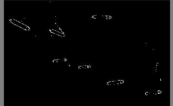
Effective features must be extracted in order to distinguish ships from false alarms after ship candidates have been identified. As a result, we use a two-step approach to distinguish ship targets. To begin, clearly false targets are eliminated through straightforward shapeanalysis.Second,atrainableclassifierbasedonthe structure-LBP descriptor is used to determine whether theshipcandidateisarealship.
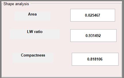
1) Area: The number of pixels in the connected region corresponds to the area in this case. The rangeofshipsisverylimited;Consequently,this constraint allows for the elimination of land, clouds, and other obvious false targets that are eithertoolargeortoosmall.
2) Length–WidthRatio:Itisdefinedas
(5)
where and are the length of the long and short axes of the bounding rectangle, respectively.Mostshipsarelongandthin;therefore, this simple method can eliminate false alarms that haveverylowratios.
p-ISSN:2395-0072
3) Compactness:Compactness measuresthedegree of circularsimilarity,andisdefinedasfollows: (6)
wherePerimeterandAreaaretheperimeterandareaofthe correspondingconnectedregion,respectively
Even after analyzing the shape, there are still some subtle false alarms that may have a shape that is similar to that of real ships. For the purpose of final ship identification, we must therefore conduct additional visual analysis of their features. During this stage, we encode the retained candidate patches with a brand-new structure-LBP feature descriptor. To encode these competitor fixes really, we resizeeachfixtoadecentsize(40×40pixelsinthisletter) and afterward extricate its construction LBP descriptor of eachresizedfix.Basedontheinherenttopologystructureof shipbodies,theresizedpatchisdividedintofourareas.The prow, left hull, right hull, and stern are the four regions. Because it is typically v-shaped, the prow is cropped as a single area. A ship's body is bilaterally divided into two symmetrical regions in the middle. The stern has been cropped as a separate area in order to account for wake interference. The LBP feature descriptors are then independently extracted from each region. At last, we link these nearby descriptors into a worldwide descriptor namedstructure-LBPinclude.Thestructure-LBPdescription separates out LBP features for different regions, which can maketheprocessoftrainingthenextclassifiereasier.
Region-based features make it easy for the classifier to assign different weights to different regions based on their importance, as different regions are important to the recognition process in different ways. As a result, the proposed structure-LBP, which combines spatial information with local features, can produce a ship description that is more discriminative than the original LBP. After highlight extraction, we utilize the AdaBoost calculation to create the speculations for ships. By maintaining a set of weights over the training set, the AdaBoost algorithm aims to transform a weak learner into an arbitrarily accurate "strong" learning algorithm. Increasing iterations are used to update these weights on a regularbasis.Aweightedmajoritywasreachedafterseveral iterations.voteoftheweakhypothesesisgenerated,making thefinalhypothesis.Whatshouldbeemphasizedhereisthat hypothesis generation is performed completely on the trainingdataset.
International Research Journal of Engineering and Technology (IRJET) e-ISSN:2395-0056
Volume: 11 Issue: 08 | Aug 2024 www.irjet.net p-ISSN:2395-0072
In order to improve the detecting efficiency, our method uses a fixed-size detection window with the same size as the training samples. So each candidate patch will be resized to have the same size with detection window beforetargetdiscrimination.
International Research Journal of Engineering and Technology (IRJET) e-ISSN:2395-0056
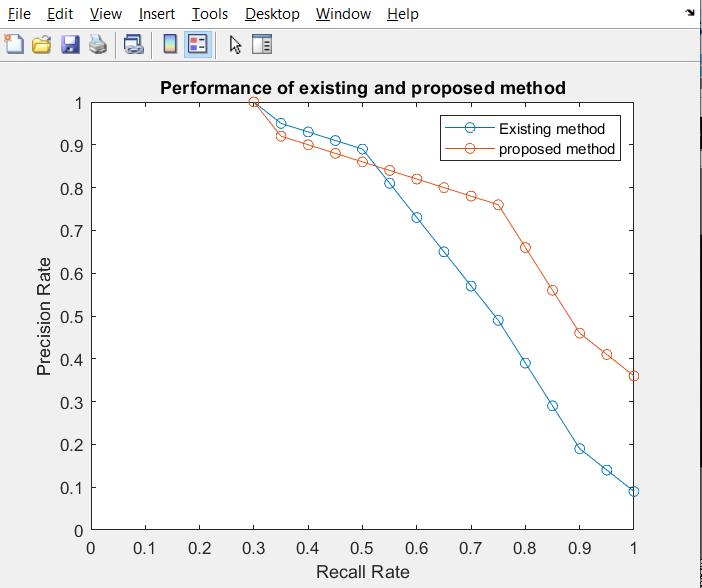
Table-1 Comparisontable.
Anovelshipdetectiontechniqueforopticalsatelliteimages was presented in this letter. To locate potential regions, this strategy incorporates contextual analysis, intensity distinctness, and pattern distinctness into a saliency segmentation framework. These three image cues make it simple to separate suspected targets from the background clutter. In addition, it is proposed to distinguish actual ships using a structure-LBP feature that identifies the inherenttopologystructureofships.
[1] Yuan Yao, Zhiguo Jiang, Haopeng Zhang Highresolutionopticalsatelliteimagesimulationofshiptarget inlargeseascenes20162153-7003
[2]Xiaoyang Xie; Qizhi Xu; Lei Hu, et al. Fast ship detection from optical satellite images based on ship distributionprobabilityanalysis.InternationalWorkshop on Earth Observation and Remote Sensing Applications, 2016:152-155.
[6]Guang Yang; Bo Li; Shufan Ji; Feng Gao Ship Detection From Optical Satellite Images Based on Sea Surface Analysis, IEEE Geoscience and Remote Sensing Letters ( Volume:11,Issue:3,March2014).
[7]Yiqun He; Xu Sun; Lianru Gao; Bing Zhang, Ship Detection Without Sea-Land Segmentation for Large-Scale High-Resolution Optical Satellite Images, IGARSS 2018 -
[4] Sergey Voinov; Frank Heymann; Ralf Bill et al. Multiclass Vessel Detection From High Resolution Optical Satellite Images Based On Deep Neural Networks IEEE InternationalGeoscienceandRemoteSensingSymposium 2019,189–199.
[5] Yin Zhuang, He Chen, Haotian Zhou et al. Comprehensive Structure Voting Docked Ship Detection from High-Resolution Optical Satellite Images Based on Combined Multi-Orientation Sparse Representation, IEEE International Geoscience and Remote Sensing Symposium 2019.
[8]Yu-Hui Ma; Ying Yu et al. Multi-Scale Salient-Region Detection for Optical Remote Sensing Images: 2021 International Conference on Electronic Information EngineeringandComputerScience(EIECS)23-26,
[9]Mesut Kartal; Osman Duman Ship Detection from Optical Satellite Images with Deep Learning 2019 9th International Conference on Recent Advances in Space Technologies,11-14June2019.
[10] Chunbo Zhu; Danpei Zhao; Jing Qi; Xinhu Qi; Zhenwei Shi. Cross-Domain Transfer for Ship Instance Segmentation in SAR Images, 2021 IEEE International GeoscienceandRemoteSensingSymposiumIGARSS.
Volume: 11 Issue: 08 | Aug 2024 www.irjet.net p-ISSN:2395-0072 © 2024, IRJET | Impact Factor value: 8.226 | ISO 9001:2008
[3] Shuchen Wang; Hairan Sun; Yihang Zhu, et al. SA-YOLO: The Saliency Adjusted Deep Network for Optical Satellite Image Ship Detection. IGARSS 2022 - 2022 IEEE International Geoscience and Remote Sensing Symposium,17-22July2022. 2018 IEEE International Geoscience and Remote Sensing Symposium,22-27.