
RETREAT OF THE ANDEAN GLACIERS
Mapping resilient strategies for melting territories
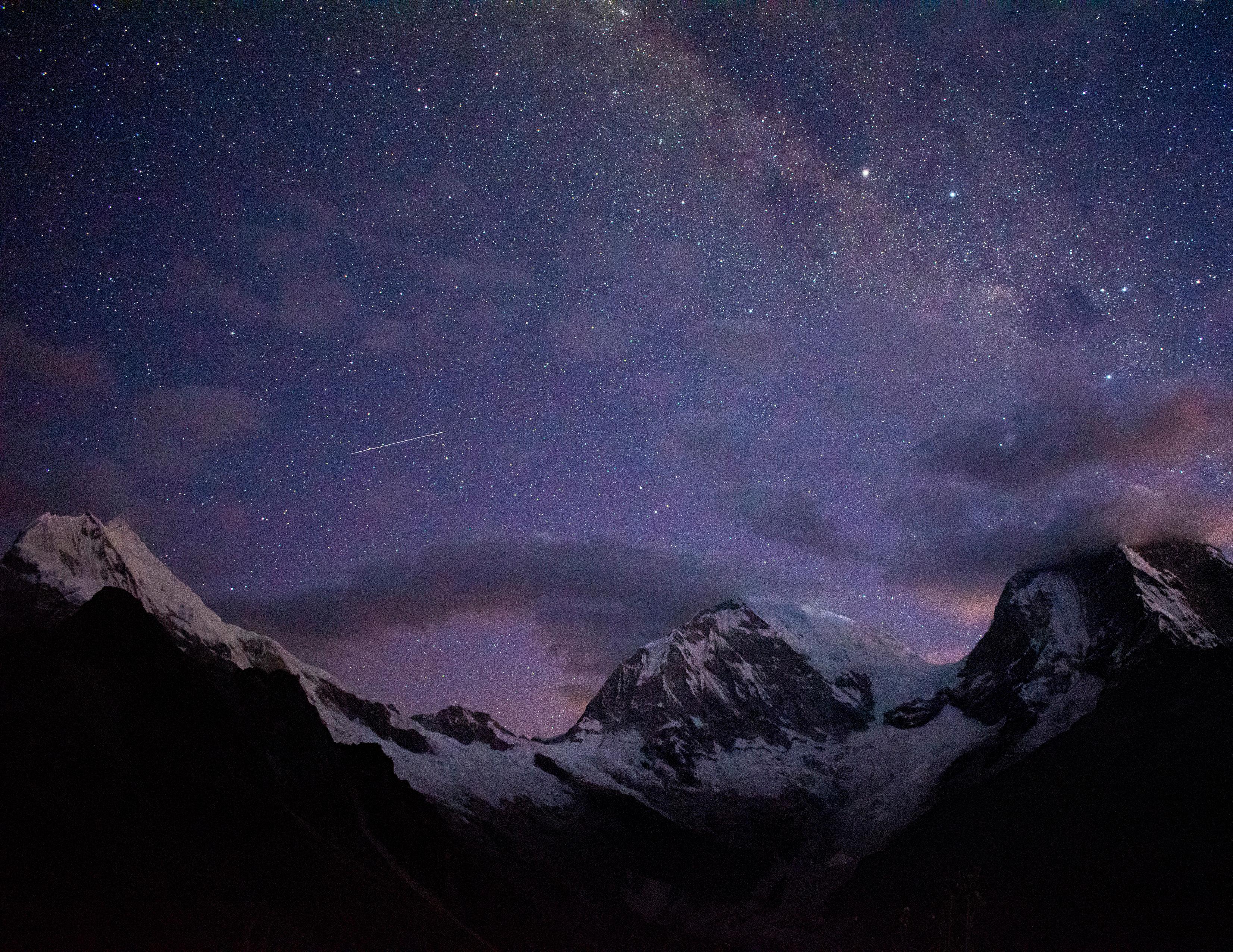
My passion for the astrophotography has allowed me to understand different territories and vulnerableAndeancommunitiesthatsurvivetotheextinctionoftheirglaciersduetoclimatechange.
This has led me to start in 2023, a research to study the phenomenon of the retreat of Andean glaciersofPeru,myhomeland,inordertotakeactionintheprotectionofmountainecosystemsand strengthen the resilience of high Andean communities. This research travel proposal is part of that process,thebeginningofajourneythatseeksitsfuturecontinuityindefenseoftheglacierterritories.
ABSTRACT
This proposal seeks to identify, characterize and geolocate community experiences and wisdom for adaptation to the rapid melting of glaciers in the tropical Andes. Specifically of the communities of the city of Yungay, the scene of the most catastrophic natural disasters recorded in Peru, related to climate change.
This, with the objective of defining resilience strategies for the implementation of public policies and rural landscape design, in order to allow its replicability in other contexts of vulnerability and territorial injustice.
Through the use of the ARCGIS Storymaps tool, the aim is to consolidate as a final product, the findings, maps and conclusions of a process that aspires to be co-created with, from and for the community in collaboration with different local actors, authorities and NGOs.
THE ANDES & THE CLIMATE CHANGE
Regional context
The Andes are the longest continental system of mountain range in the world. It is the backbone of South America, uniting 7 countries within the región and also is the main wáter reserve of the región, providing water directly to over 75 million people and also benefiting 20 million downstream.
However, as a consequence of the increasing global carbon emissions, which produce a greenhouse effect on the planet, the increase in global temperature has accelerated glacier melting processes.
According to several studies, glaciers in the Andes have lost more than 40% of their surface in the last 30 years, and specialists predict that by 2100 these could disappear or be significantly reduced, especially in the areas closest to the equator, “the tropical Andes”, with estimated losses of between 78% and 97% of glacier volume, threatening a natural ecosystem of global scale and the lives of many communities, most of which live in extreme poverty and vulnerability.
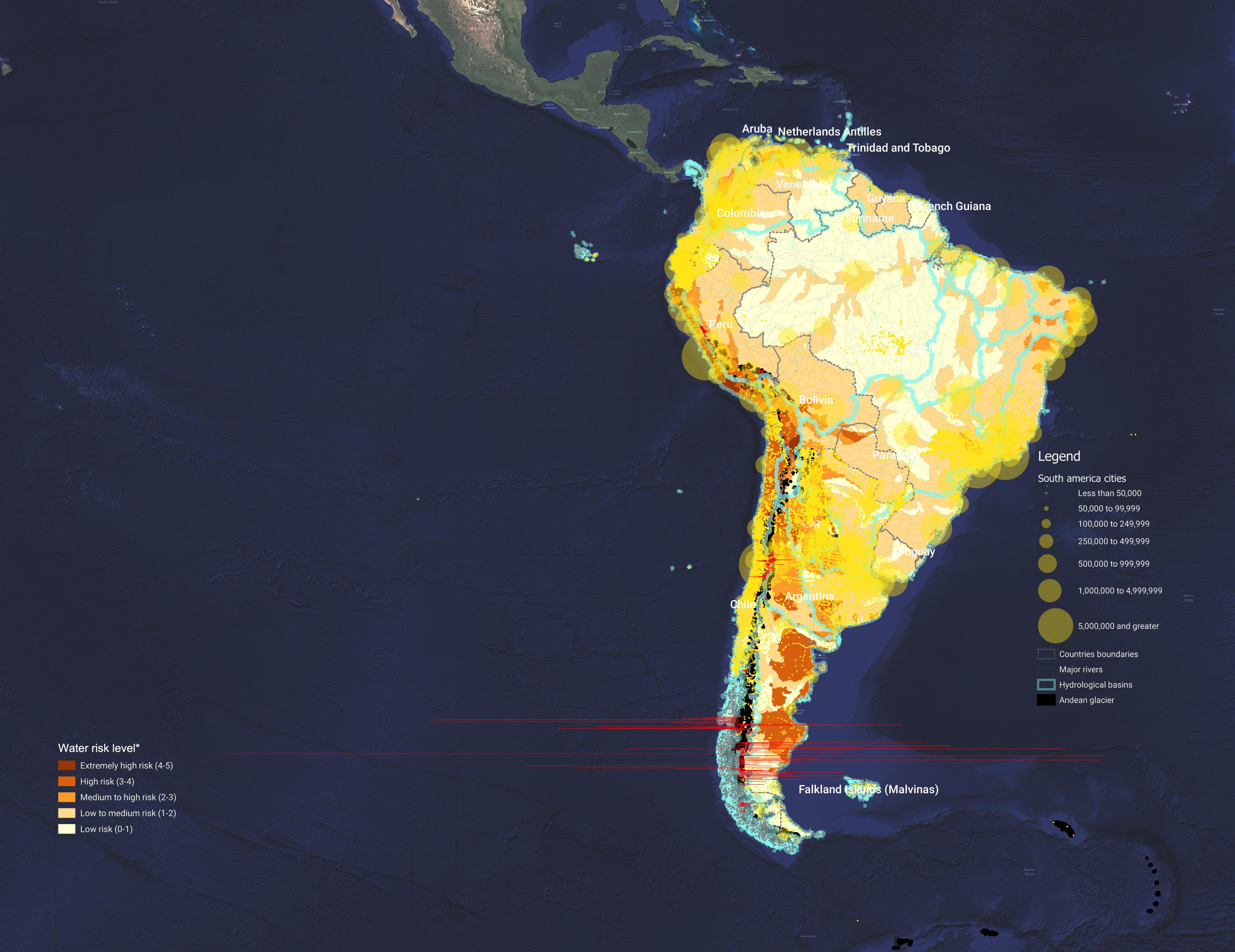
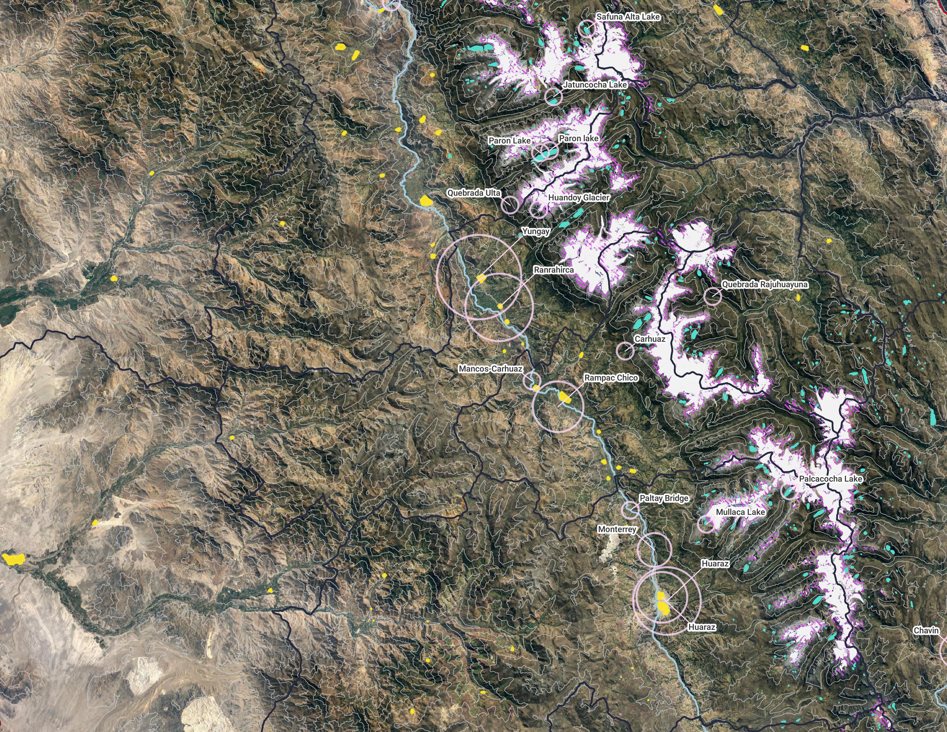
Map of Areas at water risk
*includes 12 global indicators: Baseline Water Stress, Inter-annual Variability, Seasonal Variability, Flood Occurrence, Drought Severity, Upstream Storage, Groundwater Stress, Return Flow Ratio, Upstream Protected Land, Media Coverage, Access to Water, Threatened Amphibians.
RETREAT OF ANDEAN GLACIERS
Place and memory of the lost
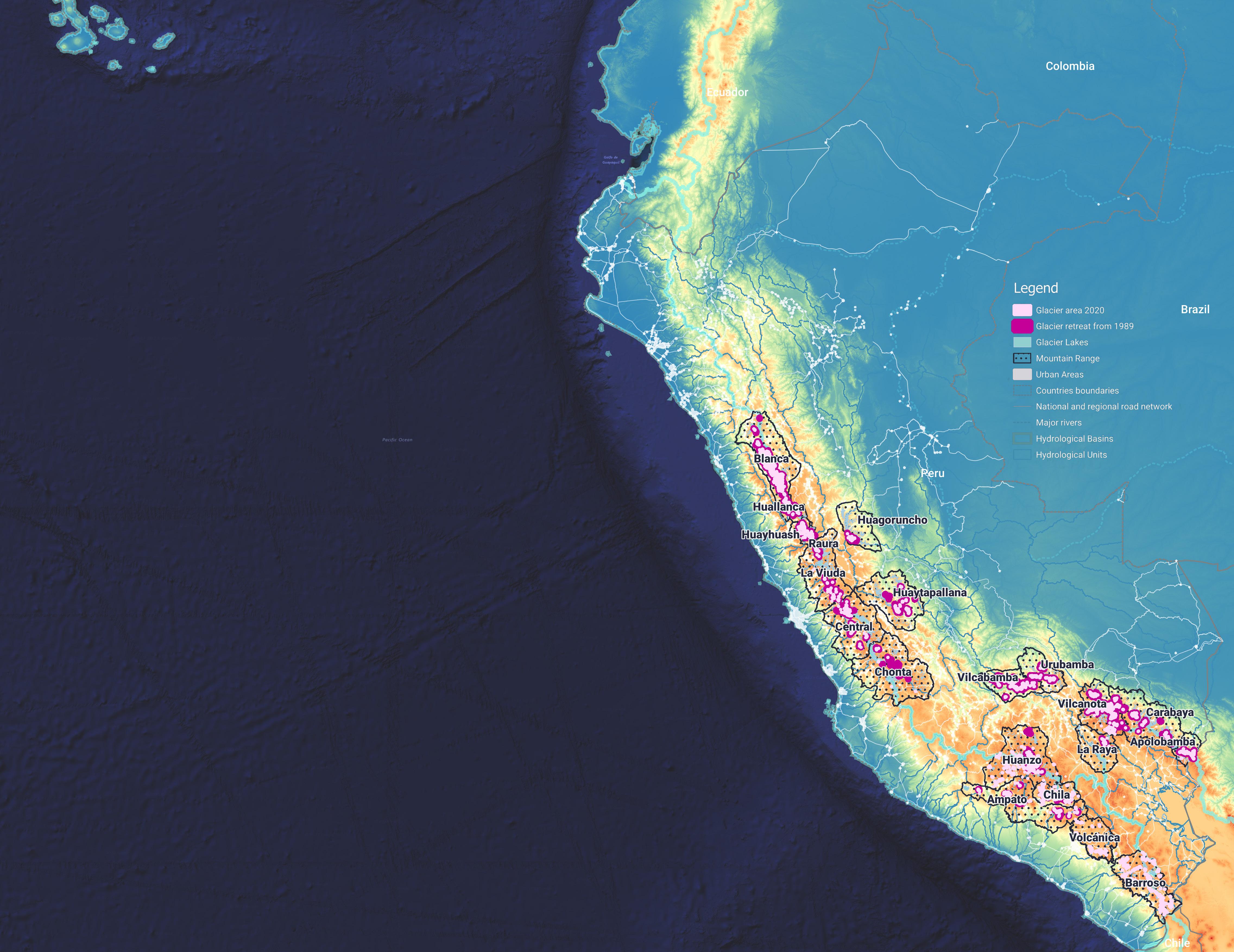
The glacier retreat is aggravated in the tropical zone of the Andes, where 68% is in Peru and which in the last 60 years has lost more than 56% of its extension. According to the National Inventory of Glaciers and Glacial Lagoons 2023 (Ministry of the Environment of Peru - MINAM), there are 20 glacier ranges within this territory. However, the 0.75ºC increase of the last 100 years, has caused the near disappearance of one of them and local specialists warn of the early extinction of five more in the next 15 to 20 years.
This accelerated process not only threatens the geography and natural ecosystems associated with the mountains. It also places rural high Andean communities on the road to extinction, which will be affected by the decrease in water supply and, consequently, food insecurity. Several national and international actions are being taken in this regard, however, these only address the problem from a top-down planning, with results of engineering projects or installations (generally early warning facilities), with no sustained processes for the inclusion and strengthening of the community towards adaptation to climate change.
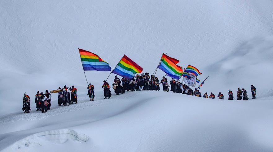
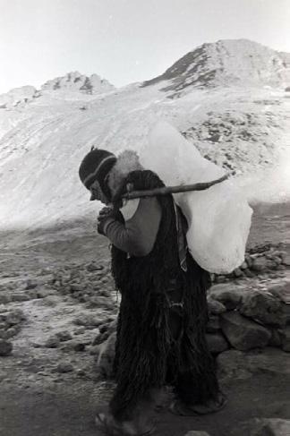
These transformations in the landscape not only impact practices associated with water resources, but also cultural traditions. For example, every year in the Cusco region, the massive “Pilgrimage to the sanctuary of the Lord of Qoyllur Rit’i”1 takes place, a glacier ceremony of Andean origin, where diverse brotherhoods of Ukukus2, ascend to the peaks of the glaciers to pray to the Apus3 for the well-being of the community and return with large chunks of ice strapped to their backs, which are melted and used in healing and spiritual ceremonies throughout the year.
Although the ritual is still practiced, since a large part of the glacier has melted, from 2001 the communities and brotherhoods that manage this ceremony have restricted the tradition of taking sacred pieces of ice from the mountain in an act of solidarity and empathy to face the imminent climate change. A testimony of human resistance against the destruction caused by global warming.
FROM WHITE RANGE TO FADING RANGE
Objective and general scope of research
The melting of Andean glaciers is drastically transforming the landscape and memory of rural territories and communities.
Therefore, this research seeks to identify and understand the adaptation actions of Andean communities to face the serious and imminent phenomenon of glacial retreat in the tropical Andes of Peru.
This, in order to define strategies of resilience that take into account the memory and community learning, as well as their millenary knowledge about the territory. In this way, the aim is to articulate local experiences for the construction of public policy strategies and rural landscape design, allowing their replicability in other contexts of vulnerability and territorial injustice
Bytheauthor
Research scope
Background of the study & research scope
This research is a process that started in 2023 from a series of academic assignments based on data collection and analysis of geo-spatial information, and now seeks its continuity in the real practice from a pilot or case study.
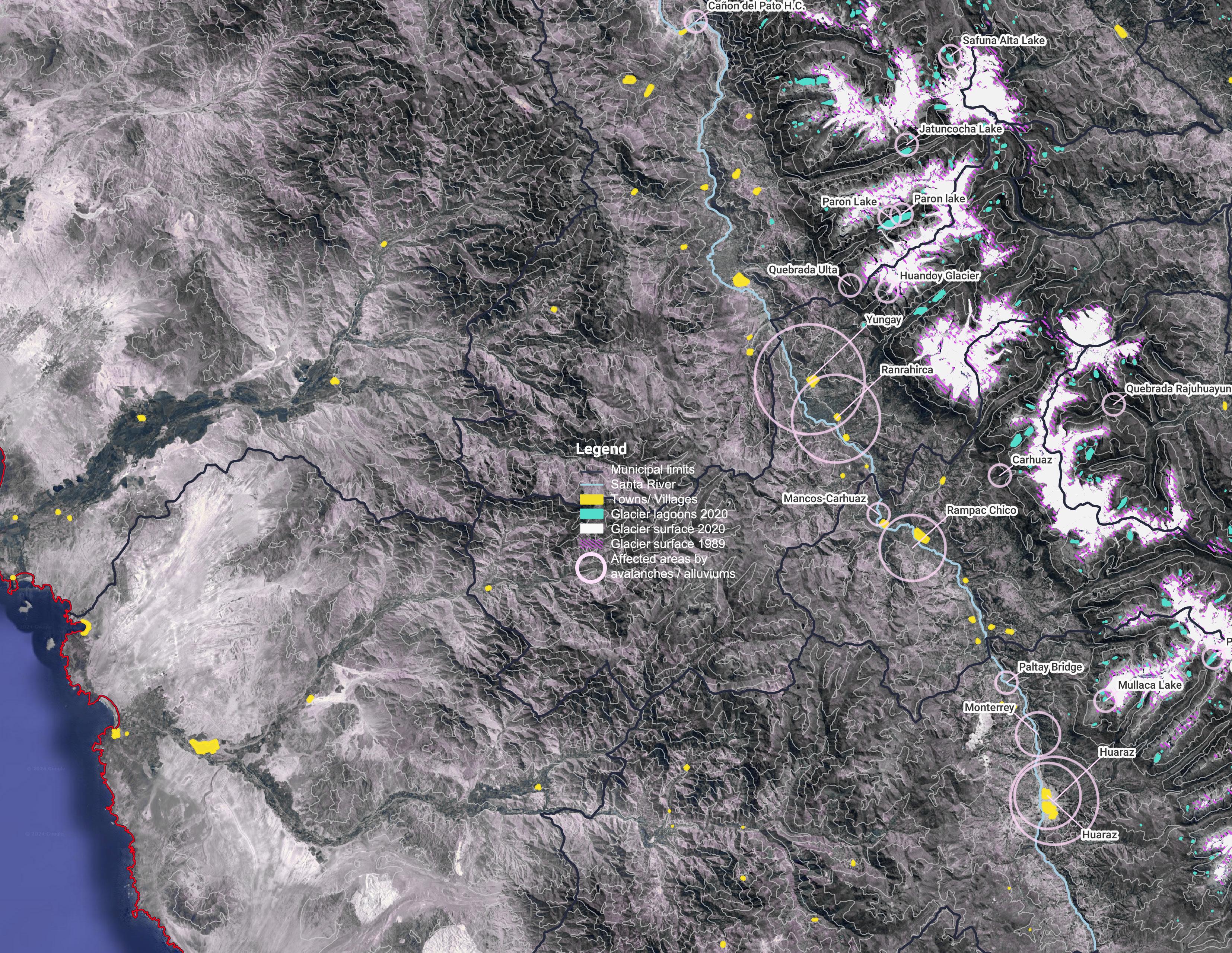
As a result of a preliminary diagnosis (map on page 2), the areas with the greatest water risk associated with glacier melting were identified, being the most affected the White range or Cordillera Blanca in Spanish, Peru’s most extensive mountain range located in the Ancash region.
This mountain system is also the one that has lost the most glacier surface between 1948-2019 (249.46 km2 - 39% of its total area), with an average annual glacier retreat of 19 meters. It is one of the places where more “glacial lagoons” have originated as a result of glacier melting. Large natural water bodies that expand and increase rapidly on the slopes of the mountains.
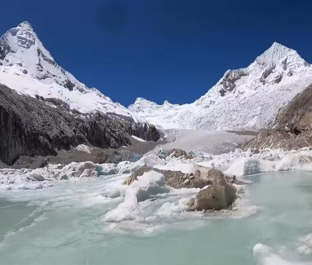
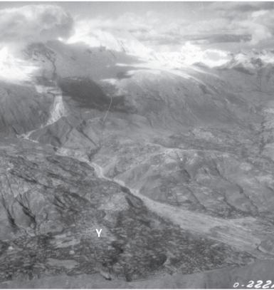
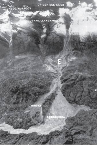
A latent and imminent threat that has historically intensified the impact of natural disasters in the area. Such as the case of the town of Yungay, site chosen as a case study and scenario of the most catastrophic alluviums* and avalanches* in the history of Peru.
Today, this place is one of the most important tourist destinations in the country, it has an offer based on its archaeological sites and its glacial landscape, even offering “exclusive” routes to explore the new “frozen lagoons”, which are actually the opposite, the proof of the agony and extinction of the glacial mountains.
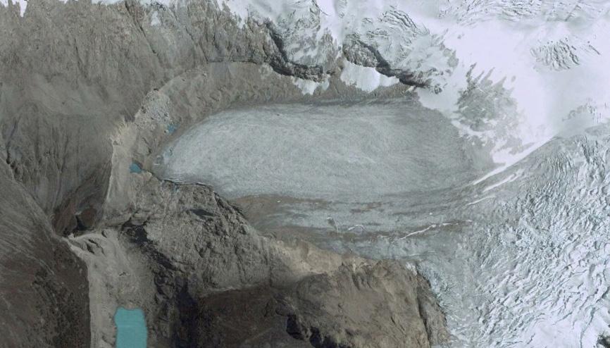
Processofglacierlagoon-UpperParonLake GoogleEarth,2023
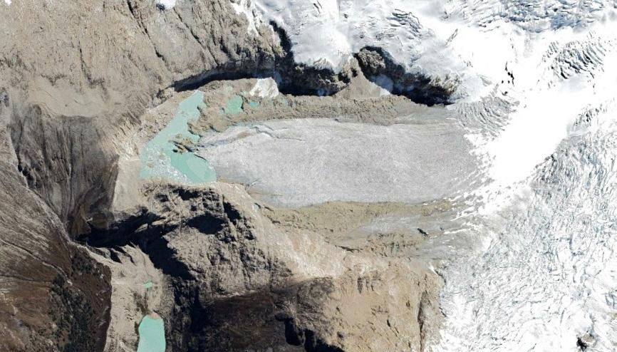
Processofglacierlagoon-UpperParonLake GoogleEarth,2003
Processofglacierlagoon-UpperParonLake Youtube, 2023
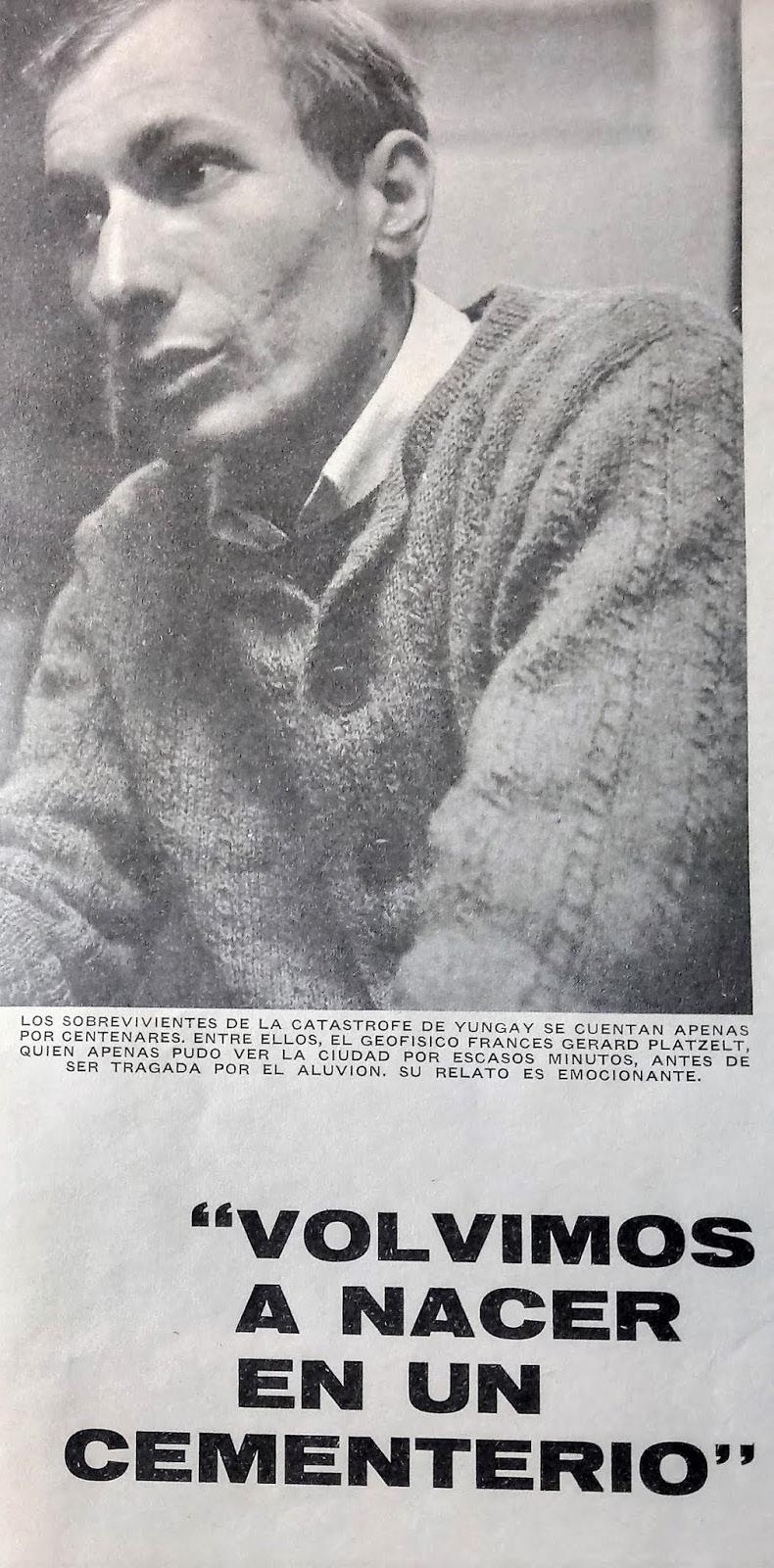
“WE WERE REBORN IN A CEMETERY”
Seed of study: Yungay tragedies
The town of Yungay is probably the place that has suffered the most consequences in Peru, due to the rapid melting of glaciers and the overflow of glacial lagoons as a result of the drastic increase in temperature worldwide.
These are two of the most painful milestones that marked the history of this town:
January 10, 1962. Local time: 6:15 pm
The landslide of a rock due to the melting of the west face of the north peak of the Huascarán snow-capped mountain, generated an avalanche that killed 4000 people and completely buried the town of Ranrahirca and seriously affected the town of Yungay as well as more than 12 communities.
May 31, 1970. Local time: 3:23 pm
The tragedy that some called at the time “the most lethal disaster in the history of the western hemisphere”, where an avalanche and alluvium in the town of Yungay, (caused by an 8.0 magnitude earthquake very close to the city) killed more than 30,000 people, saving only 300 lives, most of whom were paradoxically in a cemetery located in a high area of that town.
FROM WHITE RANGE TO FADING RANGE
Methodology & deliverable
The main focus of the research travel is the areas directly affected by the impact of the natural disasters that occurred in 1962 and 1970, in order to contextualize the findings in relation to the tragic and adverse situations that vulnerable communities suffered during those events. This process is structured in 3 phases:
PHASE I: Planning
-Preparationofmaterialsforthesitevisit
-Coordinationwithlocalactorsforfuturemeetings
-Designofthemethodologyforworkshop
PHASE II: Field work
-Visitandcollectinformationonthemostaffectedplaces
-Communityworkshopsincoordinationwithlocalgroups
-Meetingwith authorities and NGOsoperatinginthearea
PHASE III: Processing of findings
-ConstructionandorganizationofdatainGISformat
-ConsolidationofallinformationintoaStorymap
-Presentingandsharingfindingswithinvolvedparties
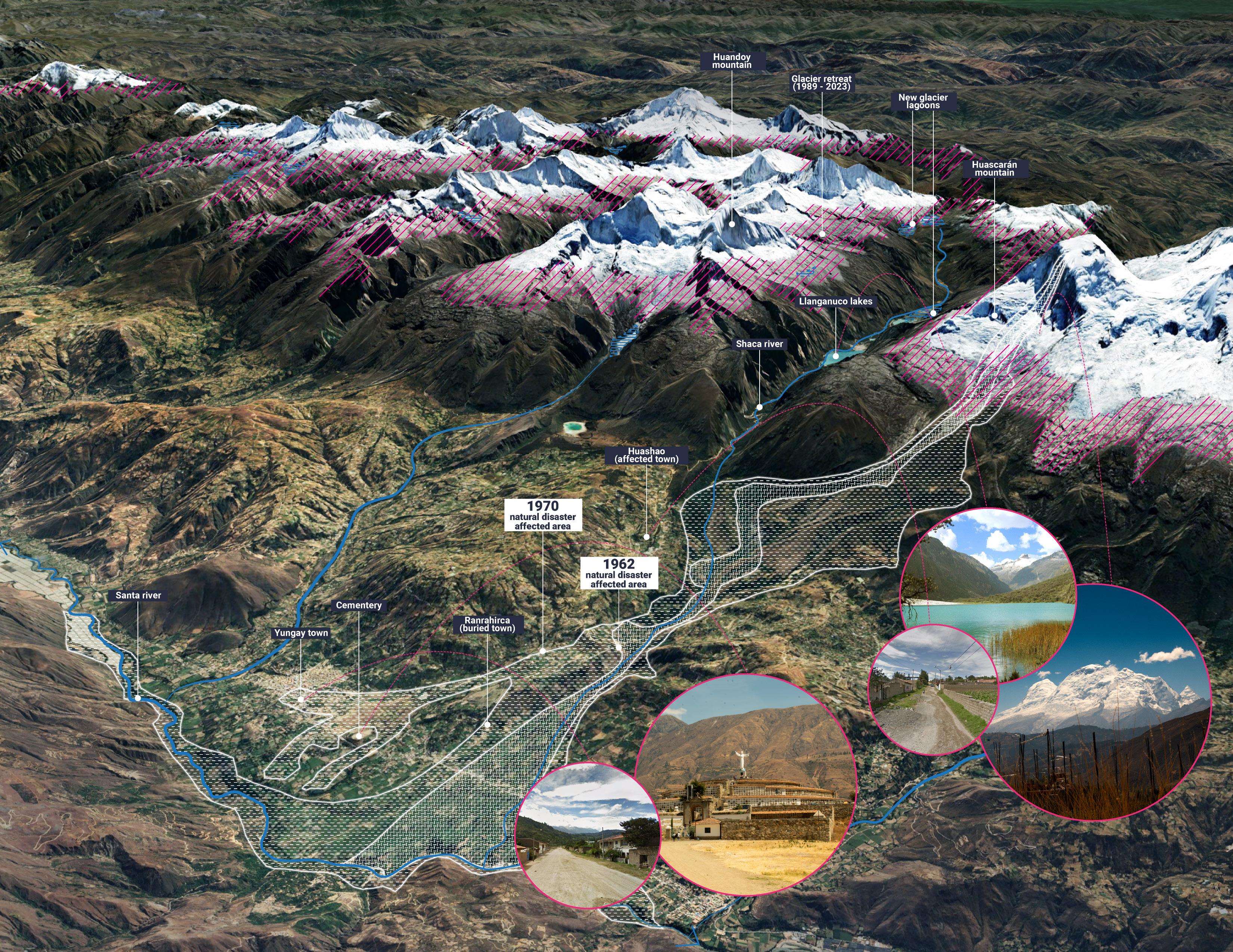
Geo-spatial context of Yungay Town and the natural disasters of 1962 & 1970
Picturesanddiagrambytheauthor
The deliverable is intended to be shared through an ARCGIS Storymap as a final report that includes digital maps, graphic and photographic material of the findings and conclusions. It is intended to be an open resource for sharing and use by the community, local stakeholders, interested parties and specialists in the subject.
ALONG THE COURSE OF THE ICE
Itinerary & potential partners
The travel agenda is structured in time and space in a 10-day site visit through the most affected areas by the natural disasters of 1962 and 1970.
As shown in the timeline below, first covering lower and urban areas, where workshops with the community and meetings with experts will be developed; then in the medium altitude areas, where rural communities will be visited and interviewed; finally in the higher lands, where the new frozen lagoons and glacier mountains in the process of melting will be visited.
Finally, a structural part of this itinerary is to engage with the community practicing a culture of sensitivity and respect, as well as to build collaborative relationships with potential partners and local experts for the construction of a collaborative and sustainable research project.
The potential partners are: Local Authorities + NGOS + Community organizations (With whom contact is made)
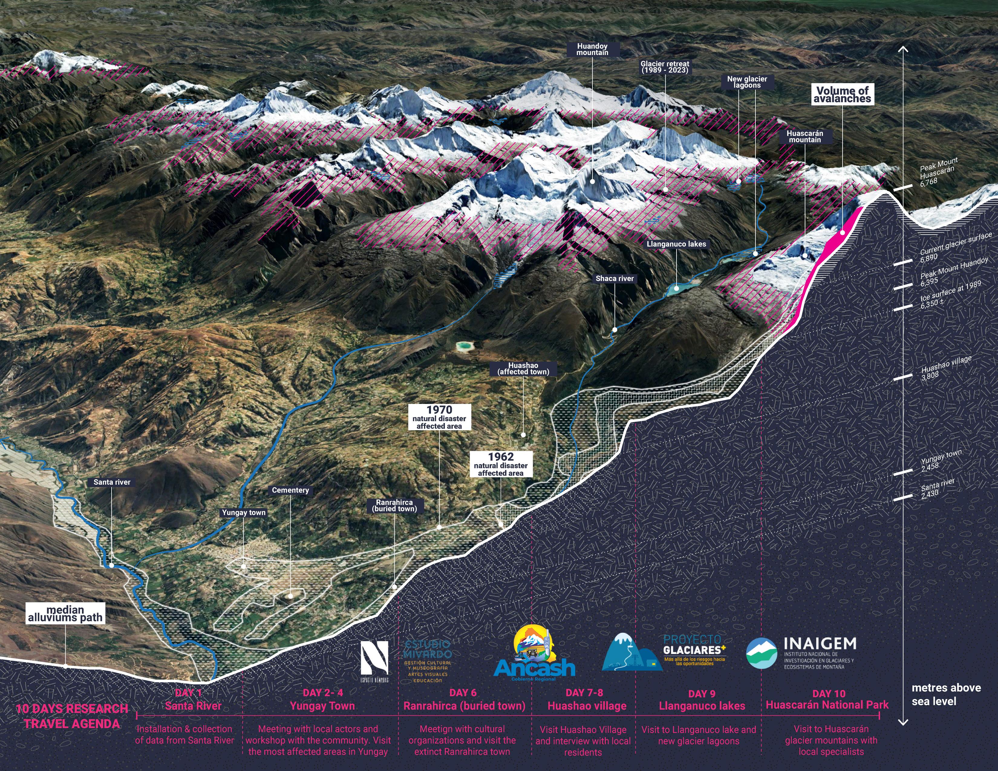
Diagram of places to visit along previous avalanches path
Diagrambytheauthor
BIBLIOGRAPHY
Schoolmeester, T., Johansen, K.S., Alfthan, B., Baker, E., Hesping, M. and Verbist, K., 2018. The Andean Glacier and Water Atlas –The Impact of Glacier Retreat on Water Resources. UNESCO and GRID-Arendal.
Gassert, F., M. Landis, M. Luck, P. Reig, and T. Shiao. 2014. “Aqueduct Global Maps 2.1.” Working Paper. Washington, DC: World Resources Institute.
Carey, M. 2014. Capítulo 1. El deshielo destruye una ciudad: Huaraz, 1941. In Glaciares, cambio climático y desastres naturales: Ciencia y sociedad en el Perú. Institut français d’études andines. doi:10.4000/books.ifea.11349
Carey, M. 2014. Capítulo 5. En busca del peligro: definiendo y defendiendo las zonas de peligro. In Glaciares, cambio climático y desastres naturales: Ciencia y sociedad en el Perú. Institut français d’études andines. doi:10.4000/books.ifea.11369
Inventario Nacional de Glaciares y Lagunas de Origen Glaciar 2023 / Instituto Nacional de Investigación en Glaciares y Ecosistemas de Montaña, Huaraz, INAIGEM, 2023 (https:// repositorio.inaigem.gob.pe/handle/16072021/499)