
revealing culture in the fabric of our cities
urban planning


culture
the patterns of human activity and the symbolic structures that give such activities significance and importance

Today, planners and developers are challenging the traditional role of the architect as solely an “object-maker.” The sustainability of current practices is in question, so new urban designs and buildings themselves must respond to an expanding agenda, including
Carrier Johnson + Culture espouses design priorities that always put people first. This design approach values the individuals who experience our places and the cultures they inform. environmental , social and artistic considerations .
Grounded in this principle is the firm’s philosophy of urban design – an expressive, and ultimately tangible means of revealing culture in the fabric of our cities. However, this belief continues beyond just design for cities and into place-making for individual projects. All of our designs are inspired by urban concepts – walkability, sustainability, adaptability – for a more livable and enjoyable future.
Carrier Johnson’s urban design services involve visionary planning concepts from small districts to entire cities, including:
{— urban design studies
— campus master plans
— design and development guidelines
— redevelopment plans
— specific plans
— public private development master plans
— community plans
the evolution of successful
city - making
Cities don’t just evolve on their own. They are the result of strategy, planning, architecture and landscape initiatives that are based on the following core values:

2
maintain connections
To preserve and enhance the character of a community, recognizing that culture and context are the source of creative inspiration, and connection at all levels integrates the community to its surroundings.
create authentic experiences
To create memorable places that have a distinctive identity and sense of place –the resulting experiences are authentic because they grow from the collective interests of the people who use the places.
4
sustain environmental resources
To seek innovations in environmental thinking, the application of new technologies, and the enhancement of enlightened social/cultural structures that lead to a creative and sustainable future. To conserve and protect environmental resources. To create sustainable smart-growth communities with vitality through a responsible design philosophy that is sensitive to the eco-system.
5
promote catalytic and transformational development
To support catalytic redevelopment by revitalizing and enlivening an existing community and its culture, recognizing that the neighborhood is the building block of a community. To anticipate the organic evolution of communities, acknowledging that the design of memorable places will be influenced and shaped by its interaction with physical and intellectual changes over time.
6
create civic art
To shape the city and community with art that integrates beauty, meaning and function. To foster a sense of identify and belonging by unifying the public realm and private development.
{When combined with our holistic design approach, these principles enliven our cities with memorable places and experiences.


C t es and places ga n spec i al character when they represent the thoughts, att tudes and deas that descr be the i me – and can layer these representat ons l ke a tale of many chapters L kew i se, s x d st nct concepts are proposed for the Horton
LAYERS OF TIME


Plaza Redevelopment Pro ect, compr s ng a s ngle compell i ng story –descr bed as “ Layers of T me .”
Each concept captures a m lestone n San D ego s h story : From the turn of the century when commerce created the c ty gr i d, to the wh msy and enterta nment of Horton Plaza wh ch was nvented to draw people back downtown from the Gaslamp and the res i dents return to the c ty streets to our current pass on for susta nab i ty as a gu de for the development of the c ty.


HORTON PLAZA san d ego, cal forn a

LAYERS OF TIME APPROACH s more than a uxtapos t on of concepts – s a system that, once establ shed, can change and evolve w thout destroy ng what came before In fact, the system s such that the add on of new layers is expected and encouraged, w th each add t on result ng n an enr ched exper ence


REPRESENTED TIME PERIOD: ALL TIME PERIODS
PUBLIC SPACE NETWORK


REPRESENTED TIME PERIOD: 1880s TO 1900s


REPRESENTED TIME PERIOD: 1985
HISTORIC PORTALS
The publ c realm surround ng Horton Plaza transforms the urban gr d into a network of streets and near parks
We ntend that the publ c realm flow from street to mall, and back To accompl sh this ob ect ve, we br dge the d v de between Horton Plaza s per meter and the surround ng streets through un ty of landscape and hardscape By connecting per meter green zones w th the c ty s ne ghbor ng streets, the publ c space exper ence becomes more compell ng
The cont nuat on of the gr d s marked w th portals anchored by h stor c experience a d st nct layer of t me is evoked each me a v s tor enters through these portals Th s s accompl shed by drawing attent on to the four s gnificant turn-of-the-century bu ld ngs ex st ng along the outer per meter of Horton Plaza as formal entrances nto Horton Plaza
ORIGINAL MALL CORE
Recogn ze the b rth of Horton Plaza and celebrate its mportance n San D ego h story by preserving key art facts, spaces, urban accessor es, and enterta nment themes of arch tect Jon Jerde s 1985 des gn


REPRESENTED TIME PERIOD: PRESENT DAY
THE LIVING STREET
The arch tecture of the “L v ng Street” s nsp red by the need to prov de part c pants n surround ng ne ghborhoods w th the necess es of ife on a single street We ntroduce the v sual vernacular of the urban street nto the fanc ful world of Horton Plaza s or ginal core to synthes ze urban- nsp red, formbased arch tecture w th a sense of fun Emphas s s on the street level w th build ngs above form ng creat ve abstract ons of the urban build ngs that ne the c ty street


REPRESENTED TIME PERIOD: FUTURE
BRIDGE GALLERIA
The Br dge Galler a and ts ser es of layered br dges look to the future wh le seek ng des gn nsp rat on through San D ego s own deep-rooted geolog c nature The organ c flow of bridge structures s nsp red by the natural geology of San Diego topograph c forms, nclud ng canyons, mesas and coastline
The str k ng arch tecture of the br dges needs l ttle adornments mple storefronts al gn the br dges draw ng v s tors through the space effortlessly.


REPRESENTED TIME PERIOD: FUTURE
ROOFTOP PARK AND TOWERS
Three towers respond to the vert cal ty of the surround ng bu ld ngs wh le act ng as d st nct ve placemarkers in the c ty s skyl ne Each tower possesses ts own function and character depend ng on symbolic and programmat c requ rements. L ke the Br dge Galler a, the Rooftop Park takes nsp rat on for ts des gn from natural cond ons of the San D ego env ronment, resulting n an organ c geometry reflect ng the reg on s coastl nes and canyons Th s park moves skyward to serve the needs of res dents, guests, and occupants of the three towers
BRIDGEGALLERIA
ROOFTOPPARK

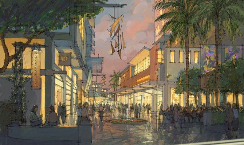
The planning of downtown San Diego’s East Village district – home of the Padres’
Petco Park – was the first effort in which a ballpark was viewed as the catalytic center of a large-scale redevelopment.


A NEW LIFESTYLE DESTINATION

Before the ballpark opened in 2004, the community was laden with futile parking lots, dormant warehouses, and a lot of potential. Recognizing this, as architects –alongside San Diego’s redevelopment agency and the Padres – we began to envision plans for a high-density, mixed-use neighborhood that would PRESERVE THE INDUSTRIAL PAST of the nationally recognized historic warehouse district.
Starting with the incorporation of the Western Metals Building into Petco Park, historic warehouses were renovated, and in many cases, incorporated directly into building forms. Like at DiamondView Tower, the building’s three- and four-story base is a traditional brick warehouse design; a modern tower rises above with lightweight, transparent glass panels and metalwork, responding to the modern city.
Next to DiamondView and at the heart of this new urban village is the community park.
An extension of Petco Park, this unique, public destination is commonly referred to as the “Park at the Park.” Within it, children can play ball in a miniature ballfield, and families can picnic on the grass. The result is a new lifestyle destination and 24/7

EXPERIENCE for residents and visitors – whether it’s game day or not.


SAN DIEGO BALLPARK DISTRICT san diego, california


REPRESENTED TIME PERIOD: ALL TIME PERIODS

public

The public realm surrounding Horton Plaza transforms the urban grid into a network of streets and linear parks. We intend that the public realm flow from street to mall, and back. To accomplish this objective, we bridge the divide between Horton Plaza’s perimeter and the surrounding streets through unity of landscape and hardscape. By connecting perimeter green zones with the city’s neighboring streets, the public space experience becomes more compelling.
The continuation of the grid is marked with portals anchored by historic experience - a distinct layer of time is evoked each time a visitor enters through these portals. This is accomplished by drawing attention to the four significant turn-of-the-century buildings existing along the outer perimeter of Horton Plaza as formal entrances into Horton Plaza.
Recognize the birth of Horton Plaza and celebrate its importance in San Diego history by preserving key artifacts, spaces, urban accessories, and entertainment themes of architect Jon Jerde’s 1985 design.
The architecture of the “Living Street” is inspired by the need to provide participants in surrounding neighborhoods with the necessities of life on a single street. We introduce the visual vernacular of the urban street into the fanciful world of Horton Plaza’s original core to synthesize urban-inspired, formbased architecture with a sense of fun. Emphasis is on the street level with buildings above forming creative abstractions of the urban buildings that line the city street.
The Bridge Galleria and its series of layered bridges look to the future while seeking design inspiration through San Diego’s own deep-rooted geologic nature. The organic flow of bridge structures is inspired by the natural geology of San Diego topographic forms, including canyons, mesas and coastline. The striking architecture of the bridges needs little adornment - simple storefronts align the bridges drawing visitors through the space effortlessly.
Three towers respond to the verticality of the surrounding buildings while acting as distinctive placemarkers in the city’s skyline. Each tower possesses its own function and character depending on symbolic and programmatic requirements. Like the Bridge Galleria, the Rooftop Park takes inspiration for its design from natural conditions of the San Diego environment, resulting in an organic geometry reflecting the region’s coastlines and canyons. This park moves skyward to serve the needs of residents, guests, and occupants of the three towers.
BRIDGEGALLERIA
ROOFTOPPARK


early ballpark district studies
Several large-scale visioning studies of downtown San Diego’s East Village neighborhood led to the development of new commercial, residential and mixed-use opportunities in the historic community.


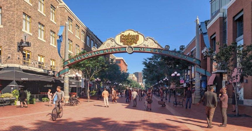
Established in the late 19th century, downtown San Diego’s Gaslamp Quarter boasts nearly 100 Victorian buildings and historic waterfront warehouses that line the former wharf. Once a blighted red-light district, the neighborhood underwent a rebirth in the 1970s when the Quarter was established as a National Historic District.


FROM RED - LIGHT TO RED HOT

Since then, major revitalization efforts have created a LIVELY
ENTERTAINMENT HUB . We first envisaged this revival at redevelopment sites anchoring the Quarter’s gateway. Here, the newly-opened Hard Rock Hotel and adjacent, mixed-use “Bridgeworks” project enliven the Quarter, completing an urban room that accesses the nearby convention center and ballpark.
Architecturally, the buildings blend industrial-inspired brick storefronts with contemporary fenestration – a nod to the warehouses that once thrived there and to the new development of the modern city. Bridgeworks, for example, remembered the site’s T.M. Cobb warehouse through the reconstruction of its original façade as a frontage to street-level retail. The Hard Rock Hotel appropriately recreated the site’s historic Depot Building as a saloon-inspired bar. Above it, glass towers open to a rooftop entertainment deck, forming a vertical showcase of “skylife.”
Today, these gateway projects do more than just welcome visitors to downtown San Diego; they INITIATE THE ENTIRE URBAN EXPERIENCE


GASLAMP QUARTER san diego, california


urban room
Together with Bridgeworks and the adjacent Omni Hotel, Hard Rock Hotel completes the walls of the city, activating an urban room with arrival, outdoor dining, hotel retailing, fountains and outdoor entertainment. Lined by the Martin Luther King Promenade and anchored by the nearby convention center, ballpark, and transit station to the south, this place, as Gateway to the Gaslamp, forms an important hub of activity in downtown San Diego.


warehouse style boxes
Although contemporary in attitude, the Hard Rock Hotel connects with the historic fabric of the Gaslamp Quarter in its multi-building approach. The complex is comprised of smaller integrated forms reflecting the scale and diversity of history’s module. Use of brick, steel and concrete reference the industrial history of south Gaslamp in a contemporary application. Incorporation of the Historic Depot Building into the Hard Rock design further embeds this dynamic new experience in the history of the area.


infill forms
Squeezed between building forms, vertical steel and glass “towers” find their inspiration in the vertical sound towers evident in outdoor rock venues. Filled with light, they form a vertical showcase of activity with restaurants, lounges, nightclubs and the rock star suites.


streetlife / skylife
The light tower on Fifth connects the street to a multifaceted urban rooftop scene. This expression of ‘skylife’ includes outdoor meeting and concert spaces, skybar/rooftop terrace and poolside entertainment.

skylife Further enlivening the hotel is a fourth-floor landscaped pool terrace overlooking the historic Quarter and a plush rooftop pool bar defined by a Fender Stratocaster-shaped overhang. Skylife also provides a 9,000-squarefoot outdoor concert space, marked with the brand’s signature tattoo.

1869 – Home to the Pacific Steamship Company, a wharf anchors Fifth Avenue – the Gaslamp Quarter’s main arterial. Warehouses of the day would later inspire much of the architectural vernacular of the area.

2000 – Once an active shipyard, the Gaslamp gateway lies dormant; the Quarter is lacking a dynamic arrival sequence.

2003 – The inception of Bridgeworks – a combination of hotel, infill retail buildings and public spaces – activates the gateway, filling the streets with tourists, shoppers and party-goers.

2008 – Erected across the street from Bridgeworks, Hard Rock Hotel San Diego completes the Gaslamp gateway – activating an urban room bound by the Convention Center and Martin Luther King, Jr. Promenade, with direct access to Petco Park.
2023 onward ...
Carrier Johnson is still working with the City of San Diego to improve the Gaslamp and Ballpark District, most recently providing designs to convert the iconic destination to a pedestrian friendly space that is comfortable for people, not cars. The project will completely transform the culture of the Gaslamp District and bring San Diego into the future while respecting its historic past.


chula vista bayfront village chula vista, california

Nestled within the natural tidelands of the San Diego Bay is a revolutionary village of canals, bridges, seasonal marshes and eco-friendly residences. The Bayfront Village visionary master plan unites the density of smart growth with the ebb and flow of the natural habitat.
people and nature co - exist
Along the outer edges of the plan, low-scale eco-bungalows emerge where individuals and small groups live within nature. Moving inward, paths are formed that draw elements of the natural environment through garden courts and increasingly urban experiences.
Anchoring the ends of the courts, multi-story buildings line a canal promenade where people gather and interact. From the promenade, bridges stretch across the waterway, connecting to the towers where people live, looking back across the village, the wetlands and the bay.
The colors, materials, forms and details throughout this place reflect an attitude of connect ion between the city and the land, and their respective inhabitants.
the district experiences
eco village Nestled into the natural environment along the park buffer, this special neighborhood draws its identity from its unique natural setting. Here, “eco-bungalows” rise seamlessly from the sticks and mud as a soft reflection of their surroundings.
the village green Lined by mixed-use buildings with street-level retail, the south face of the park has an urban feel. Along the north edge, Marina Boulevard swings away from the city grid and becomes Shoreline Drive. A view shed is created, and a sense of coastline is unveiled.
artist alley This special “micro street” derives its character from a small-scale alley feel. The pedestrian orientation and high level of expression along its edges create an atmosphere designed to foster a live/ work environment.


the grand canal This urban corridor connects pedestrians, bicyclists and rowers to commercial and recreational activities to the south. All roads and walkways lead to the canal where the water experience provides a constant reminder of the bayfront setting.
shoreline park This important nature park provides the setting for a unique environmentally-sensitive resort.
the north village Strong pedestrian connections and shared use of retail and recreational amenities bring hotel and residential uses together.
the pond A natural open space houses wildlife habitat and creates a nature setting for surrounding residential development.


preservation of the sweetwater marsh national wildlife refuge – one of the nation ’ s richest – was both a necessity and an asset to this visionary plan . central waterway and promenade circulation districts open spaces rendered site

the grand canal : close - up
the waterway
Kayaks and rowboats create recreational opportunities and an alternative to walking. the towers
The two towers that flank the Village Green include midrise and highrise elements climbing to the highest point within the community. To the south, residential towers along the Grand Canal descend in height. the promenade
A wide promenade along the west side of the waterway provides a pedestrian connection across the community and functions as an important community meeting place.
the east edge
Elevated ten feet above the waterway, the East Edge is a man-made bluff that provides the setting for residential towers with spectacular bay views.
garden courts
Midrise housing features landscaped courts, balconies, porches and entry gardens along the Promenade. the bridges
A series of individually-designed pedestrian bridges provide access across the Canal.
motor courts
Pedestrian-friendly motor courts provide access to bridges and function as ceremonial entries to adjacent residential towers.


environmental transition
recreational greenbeltvillage gatewaytower courts grand canal garden courtsartist alley eco-bungalowsnature preservesan diego bay urban focus
the urban transition

imperial courts master plan watts, california
The Imperial Courts is a public housing project home to many African American and Latinx communities who identified a need for updated safety, security, and amenities for their existing community center. Carrier Johnson partnered with the community and the Housing Authority of the City of Los Angeles (HACLA) to develop a master plan that addressed these needs.
community partnership
Carrier Johnson + Culture teamed with HACLA to host stakeholders and residents to solicit feedback from the community. After the initial consultation, it was determined that additional community workshops should be conducted to benefit the project and to truly hear the needs of the community. During the workshops, the team met with residents of the Imperial Courts community, visitors to the recreation center, LAPD, Watts Empowerment Center staff, and members of the HACLA team. Through these workshops, meetings, and consultations, our team collected questions, suggestions, hopes and concerns to better inform the design concepts provided to the community.

underused and forgotten
The existing Community Center supports the federally subsidized HACLA project of 490 units in its surrounding. Founded in May 1944 and operated it is one of the largest housing projects west of the Mississippi.
A 2020 American Community Survey found that the total population of the area is 6,090 people with a median age of 26 years old. About half of the population lives in poverty. The current Community Center is dilapidated, abused, and jail-like.


community partnership
Our team met with individuals from the community, HACLA, LAPD officers, and other stakeholders to hold a series of design workshops to truly understand the needs of the community. Carrier Johnson + Culture believes the design should reflect the actual needs of the community and not impose design or uses. The community responded enthusiastically and helped our team to understand exactly the shortfalls of the current community center and how to overcome them.
There is a beautiful diversity in opinions and energy. Some look back at what once was, hoping to return to this central community collector. Others are engaged in the present by pinpointing current action. All are discussing how such a close family can become involved with the growth of this urban family for the future. Our team brought in a translator to facilitate conversation with the Latinx community so that all voices could be heard.
discussion topics
SPORTS
What sports/physical activities are a priority for the community?
Are there existing sports we would love to have more of?
Has there been a community volunteer/interest in returning organized sports in this park?
MUSIC STUDIO
Where would a standalone Music Studio best fit in the park?
If not a standalone building, would an expansion be best at the picnic area or the basketball court? What type programs would you like to see in the Empowerment Center expansion?
SAFETY & ACCESS
How can we ensure new improvements are safe and accessible? Should the park be locked at night?
Have you or anyone you know have problems moving around the site?
HEALTH & WELLNESS
Would the community participate in a communal garden?
Would the community seniors like to see outdoor exercise spaces?
What kind of other health and wellness activities would you like to see?
analysis and recommendations
From an observational standpoint of the community interactions, a proportionate representation of the number of topic mentions is illustrated in the below chart diagram. As the discussion flowed organically, perceptions from verbal dialogue and notations on paper were organized into graphic estimations of occurrences. In comparison to the original proposal design, community priorities and wishes are represented.


final site plan
The final site plan successfully integrates community input and addresses areas of concern such as flexibility of use, access, and safety as part of a campus master plan.
The final site plan is geared toward the final concept and includes aspects such as:
• Relocating the playground
• Utilizing areas adjacent to basketball court for outdoor
• Exercise / community activities.
• Maintaining existing basketball and futbol courts.
• Remove ball field and propose turf area at soccer field dimensions.
The final plan represents the desires of the community that will ultimately use the site and, when completed, will be a valueable asset for years to come.


quarry falls ( civita ) san diego, california

Quarry Falls (now know as Civita) responds to the natural and man-made attributes of its site –an existing sand and gravel quarry – by placing primary focus on an interactive system of parks, streams and open space to connect with two distinctly different communities; the mesa to the north and the river valley to the south.
pedestrian experiences
The social and health benefits of traditional neighborhood design that encourages safe, convenient, and pleasurable pedestrian experiences has been documented as a catalyst to improve the quality of life for residents. Civita is designed for the pedestrian first with well-lit, landscaped sidewalks set back from the street and numerous trails providing easy and timely access throughout the project. Taking cues from traditional urban neighborhoods, the project involves numerous amenities to reduce dependency on the car.
The live-work-shop-play concert is a cornerstone driving the Civita vision. The organizing element of the plan is the first public park to be built in San Diego’s Mission Valley neighborhood. The central park and feature waterfall are both a physical and symbolic connection between the mesa and river valley floor, serving as the main pedestrian corridor and linkage between site uses.
th e sit e
th e sit e
Civita will help meet its neighborhood’s planning needs for attainable homes, a new public park, public charter school and urgently needed traffic improvements, while reducing commuter traffic by offering jobs and recreation close to homes.
Civita will help meet its neighborhood’s planning needs for attainable homes, a new public park, public charter school and urgently needed traffic improvements, while reducing commuter traffic by offering jobs and recreation close to homes. the site Civita was designed to include a new public park, public charter shool and urgently needed traffic improvements, while reducing commuter traffic by offering jobs and receation close to comes.


by integrating transit , walkability , and healthy living , quarry falls is a model sustainable community
A registered LEED for Neighborhood Developments (LEED-ND) pilor project, it was one of the first three in San Diego County.


botanical voyage


The Civic Center provides indoor and outdoor space for events and activities, including the Festival Plaza, amphitheater and park areas.
The Upper Spring Arboretum is a recreational and educational garden that begins the botanical voyage to the river valley below. village walk
At the southern edge, the park extends into the Village Walk, inviting visitors to explore on foot.
The


san diego ’ s hidden treasure
Civita park is now one of the most recognized new developments in Mission Valley. With cues taken from Carrier Johnson’s original master plan the park and surrounding areas offer a haven to residents and guests, and a quality of life unparalleled by other recent developments.

pastoral village sanctuary
existing site - the carroll canyon quarry
Mining operations have been ongoing since the 1950s. As a result, the entire site has undergone considerable modification.


village center
Anchoring the community is the Village Center, located in the central portion of the Master Plan area and containing retail opportunities, residential homes, office space, and a transit stop.
stone creek central park
To the south and east of the Village Center is Stone Creek Central Park, including the Carroll Canyon Creek Open Space (comprised of a neighborhood park and riparian creek corridor), which act as the primary open space and recreation areas for residents, employees, and visitors of Stone Creek.


westside + creekside neighborhoods
Residential homes are provided west of the Village Center and south of Stone Creek Central Park in the Westside Neighborhood and the Creekside Neighborhood, respectively.
eastside district
The Eastside District of the project site is the Employment Neighborhood, which offers business park and light industrial space.


experiential richness
Inspired by the long-admired qualities of European villages, traditional American neighborhoods and the regional attributes of San Diego, we envisioned Stone Creek to be a unique community within a community, imbued with experiential richness and sense of place.
WESTSIDE NEIGHBORHOOD
VILLAGE CENTER
PARKSIDE NEIGHBORHOOD
EASTSIDE NEIGHBORHOOD

WESTSIDE NEIGHBORHOOD
VILLAGE CENTER
CREEKSIDE NEIGHBORHOOD
STONE CREEK CENTRAL PARK


string of pearls
Running throughout Stone Creek will be a network of diverse parks and open spaces, including a “string-of-pearls” park and piazza system which links to the expansive Stone Creek Central Park.

navwar master plan san diego, california

SANDAG, in cooperation with the US Navy, employed Carrier Johnson + Culture to design a new regional transportation hub and mixed use community in support of a new state-of-the-art NAVWAR Facility.
midway ’ s history & future
The scope of the design effort was to prepare a visionary master plan as the basis for or against recommendation to decision makers on how to best develop this underutilitzed piece of land. The master plan along with yield analysis, budget estimates and market study was prepared to find the balance of value and cost to public and private development. The master plan looked at the industrial history of the site, the nexus of multiple lines of transportation, and the future of the midway district in order to best recommend potential uses that would maximize the use of the land.


history
The forces that shaped the development of the Midway District during the late 19th century and early 20th century were transportation, the military, and aviation. A real estate boom brought on by the opening of the California Southern Railroad spurred a flurry of transportational developments including lightrails and freeways, including what eventually became the San Diego trolley system and the Pacific Highway.
Military and aviation developments dominated. The post-war community mainly consisted of small warehouses and commercial and industrial buildings with automobile-centric commercial uses.
setting
The current NAVWAR site is 70 acres comprised of two large parcels separated by the Pacific Highway. The community’s land use reflects its industrial orientation and impede vehicle and pedestrian travel, dominating valuable real estate along the I-5. The area has maintained its industrial character with underutilized land located in a central location in San Diego.
vision
The vision of the project is the creation of a mixed use regional transportation hub serving San Diego County residents and visitors from around the world. This hub would link rail, airport, bus and auto modes of transportation under one roof. The hub will become an anchor for a new neighborhood while creating a high tech naval facility for the 21st century. At the same time, the project would be a catalysis for redevelopment of the Midway District’s outdated land uses currently occupied by worn-out commercial strip centers and obsolete industrial buildings.


transit
A major component of the plan is a podium deck elevated above Pacific Highway envisioned both as a cover for rail lines and parking as well as to accommodate a new elevated street network. The podium deck would also serve to separate inbound and outbound circulation, to facilitate the flow of vehicle traffic movement, where the podium deck level serves vehicle drop offs to, and the ground level serves as pick up from, the transportation hub. The elevated deck above Pacific Highway can then be easily accessed from the west via pedestrian bridge to link the naval facility and remaining development. A linear park bounding the western edge of the raised podium deck would delight visitors and residents alike with views of the harbor as well as Point Loma to the west.


walkable quaint village
The Park Station Master Plan is intended to be a walkable Mixed-Use Urban Community Village that will provide future residents with ample amenities and convenient commercial retail businesses in a safe and comfortable environment. The project, known as Park Station, is a mix of residential and commercial uses which are supported by ground floor retail shops that will serve the community and daily visitors.
The project will have an assortment of living accommodations including street and courtyard-oriented flats, lofts and live/work spaces and mid-rise units, enhanced by the small neighborhood shops that could include a cafe, bakery, pet shop, restaurant, postal store, dry cleaners, beauty salon, flower shop or delicatessen.


A diagrammatic representation of site opportunities + solutions.


linear park The 1.1-acre Linear Park will serve as the primary recreational and open space for community uses. The linear park will enhance the arrival experience into the city and extend the Spring Street promenade with a pedestrian path running adjacent to the trolley tracks. A children’s playground is also proposed as a part of the park’s recreational amenities.
baltimore drive Located on the west side of the Park Station site, the proposed Baltimore Drive planning area will cover 2.24 acres running along Baltimore Drive between El Cajon Boulevard and University Avenue. This area will include mixeduse residential space comprised of 95-106 dwelling units. shopping Along the tree-lined sidewalk people will stroll and converse together, some seated at umbrella-covered café tables chatting and sipping coffee while others enter a shop to purchase a loaf of bread. Some resident may have a professional storefront business fronting the sidewalk while a resident artist may have a small gallery and have his crafts displayed in the shop window.
trolley
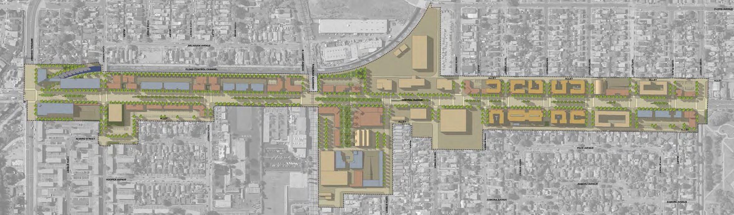
central avenue corridor study los angeles, california
The Central Avenue Master Plan focuses on a mile-long 75 acre plan area in the Watts Corridors Redevelopment Project in South Central Los Angeles. The heart of the 1965 riots, the rich diversity today represents both the African American and Latino communities. The project is one of a handful of catalytic projects in South Los Angeles that are expected to dramatically TRANSFORM THE ECONOMIC AND CULTURAL LANDSCAPE.
memorable place

The project positions the Watts community in a strategic relationship to Downtown Los Angeles, and the Central Avenue Corridor to the Watts Towers by leveraging development at key opportunity sites.
The Master Plan embraces nature through the reintroduction of LANDSCAPE AND STREETSCAPE elements. In addition, the plan provides a framework for connecting that will enable a connection to the Los Angeles River System through the Compton Creek which runs parallel to the southern half of Central Avenue.
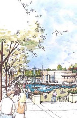
The Vision for the Central Avenue District is that of a secure, vibrant and prosperous, pedestrian friendly, green, mixed-use destination that provides EXPRESSION TO THE RICH DIVERSITY of the Watts Community, by creating a MEMORABLE PLACE to live, work and recreate for the whole family.
connection and identity
The Watts Central Avenue Master Plan focuses on a mile-long corridor in the Watts Community of South Central Los Angeles. The goal of the master plan is to revitalize the corridor through renewed investment by exploring development opportunities and enhancing public improvements.
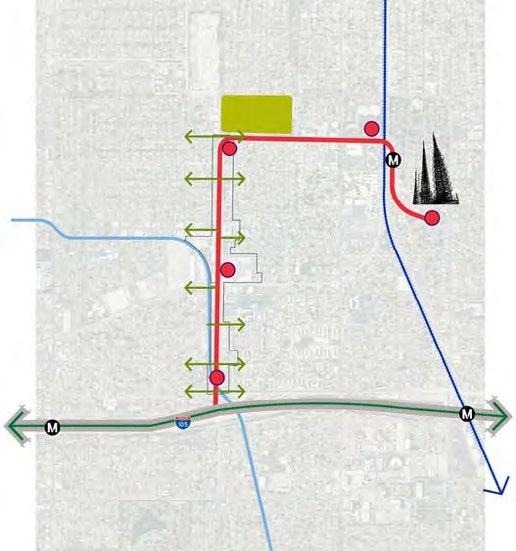
The plan identifies, evaluates and defines viable development at strategic locations that act as “markers” along the path from the virtual “gateway” to Watts from the Century Freeway, all the way to the Watts Towers, the iconic and symbolic heart of the Community. The plan leverages other projects that are currently being implemented by various agencies outside the plan area. Together, these five ”markers” lead visitors, and residents from the gateway to the Towers.
vision concept


watts towers
central avenue corridor : five distinct districts
park gateway district
The northern gateway at Ted Watkins Park extends the lush landscape of the Park to the northern section of Central Avenue reintroducing nature into the urban corridor.

boulevard housing district
The mixed use district consolidates the residential component of this section by recommending mixes-use with residential above retail.

center on central
The heart of the corridor, the Center on Central is conceived as the cultural and social heart of Central Avenue providing a node of cultural expression to the whole community.

retail mixed-use district
The district transforms the existing retail focus to a pedestrian friendly mixed-use district that reconnects Central Avenue to the community by reinforcing retail with cultural expression.


imperial gateway district
The Gateway District at Imperial is the gateway to the Watts community and the towers as a destination from other parts of Southern California.


Do you agree that public reconnect the district to natural greenscape, and support vital development is beneficial to the Watts
Do you support the creation of attractive development with active street frontage that will support jobs and revitalize the Central Avenue corridor?


revealing culture in the fabric of our cities
urban planning