5 minute read
The latest Palawan discovery the “honeycomb pavement” of the new branches of the PPUR


Jo De Waele, Paolo Forti
With the exploration of the new branches of the PPUR, we have added yet more concretions to the already exceptionally high number that we know were formed due to the particular climate of Palawan. This time, the structure is constituted by small bowls (Fig. 1, centre) grouped together so as to resemble very closely the cells of a beehive – a “honeycomb pavement”, in other words. The credit is due exclusively to Vittorio Crobu and his passion for cave photography, which has made it possible for us not only to know of their existence but also to study them in detail. Indeed, everything that we now know about these strange concretions comes from the shots that he was kind enough to take whilst exploring the new upstream branches of Daylight. On the basis of our previous knowledge of the climate of Palawan, which is characterised by short but heavy rains, and above all on what we have been able to discern from the images, it is clear that there has been a relatively long genetic process here, encompassing at least three distinct evolutionary stages. Initially, the (sub-horizontal) area was covered by a thin layer of loam and mud that was completely soaked during the wet season, whereas in the dry season evaporation caused its total desiccation, with the formation of a series of cracks resulting from the consequent decrease in the volume of clay (Figs. 2.1-2.2). Given that, during the subsequent wet period, the water failed to seal up entirely the fractures formed in the clay, the alternation of the wet and dry periods gradually deepened and widened those fractures (Figs. 2.1-2.2), which thus conserved ever-greater volumes of water. The evaporation of this water trapped in the mesh of the mud cracks led to the development of an internal concretion. Over time, then, CaCO3 filled the lattice of the cracks right up to the outer edge of the mud and, thanks to capillary rising, the concretion rose slightly higher than the mud (Fig. 2.3A). Had this process continued unchan-
Advertisement
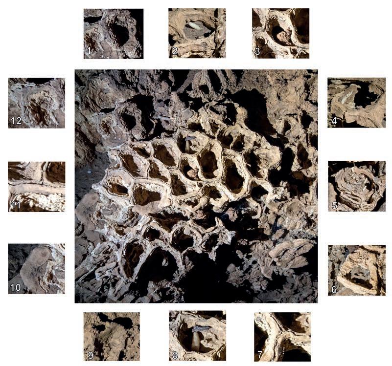
Fig. 1 – In the centre, the honeycomb pavement surrounded by the details that have enabled us to trace its development; 1) bowl partially destroyed by the flow of water along a drainage channel; 2) fragment of concretion on the recent mud base; 3) drifting pebble trapped in a bowl; 4) almost entirely destroyed structure, from which the original clayey substrate has also been eroded; 5) fragments of tubes within a highly eroded bowl; 6) recent mud sedimented within a corroded bowl; 7) close-up of the dividing walls with clear detachments of the structure; 8) fragment of stalactite and piece of non-drifting rock within a bowl; 9) recent, still-plastic mud; 10) basal portion of a totally dismantled bowl showing the mud solidified by the CaCO3 deposited within it; 11) close-up of a bowl, showing internally the concretion films formed after every flood; 12) calcite films that have developed over an almost entirely destroyed structure.
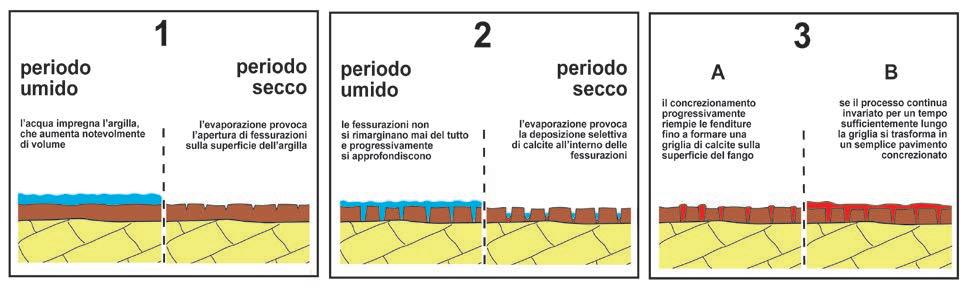
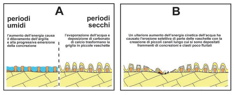
ged over time, the whole area would have ended up being covered by a relatively thick layer of concretion, thus transforming itself into a normal sub-horizontal outflow (Fig. 2.3B). Within the PPUR, however, this final stage was never able to occur because, evidently, the hydrodynamic conditions of the area changed, seeing an increase in the peak kinetic energy of the water, to such an extent as to permit a gradual erosion of the clay layer, even if delineated, and therefore partially protected, by a concretion grid. Therefore, in a relatively short period, the erosive action of the water during heavy storms removed most of the original clayey layer, thus allowing the emersion of the calcium carbonate grid (Fig. 3A, left). This lattice, with its isolated polygonal cells, gave rise to the embryonic geometrical structure, from which – thanks to the evaporation of the water cyclically trapped within – the ‘bowls’ developed (Fig. 3A, right). However, after a certain period – the duration of which can be calculated to a high degree of accurately simply by counting the growth bands in the dividers that separate the single bowls – this second stage also came to an end, giving way to a new stage, characterised by even greater hydro-energy. Indeed, in this third evolutionary stage (fig. 3B), the water erosion also affected part of the bowls that, in certain areas, have been almost completely destroyed, with the creation in their place of small flow channels. These have partially carved the limestone that functioned as a substrate of the “honeycomb pavement”. Moreover, during the high level of water ingress immediately following the great tropical storms, the power generated by the water was sufficient to transport small suspended clasts and fragments of concretions that, with the lessening of the floodwater then became trapped within the single bowls and, on occasion, even became solidified on the ground by the formation of a new concretion. As the final observation based on the general appearance of the concretion that forms the “honeycomb pavement”, we can state with confidence that the water flow disappeared some time ago, transforming them into practically inactive (almost fossilised) forms, on which the corrosive effect of condensation is starting to become more significant, while the formation of newly-formed carbonate crusts has decreased markedly. This final evolution is in perfect alignment with the fact that the “honeycomb pavement” is located on a terrace suspended over a canyon that has recently increased in depth (verbal report by Vittorio Crobu). In conclusion, I would like to underline the fact that all of the observations I make here derive from my study of two photographs taken very rapidly. It is, indeed, essential that all speleologists, rather than taking samples that, nine times out of ten, get thrown away, should always document through photographs whatever strikes them as unusual, or at least not immediately comprehensible, along the way, in order to enable specialists to make the preliminary observations without pointlessly impoverishing the subterranean environment.
ALBANIA
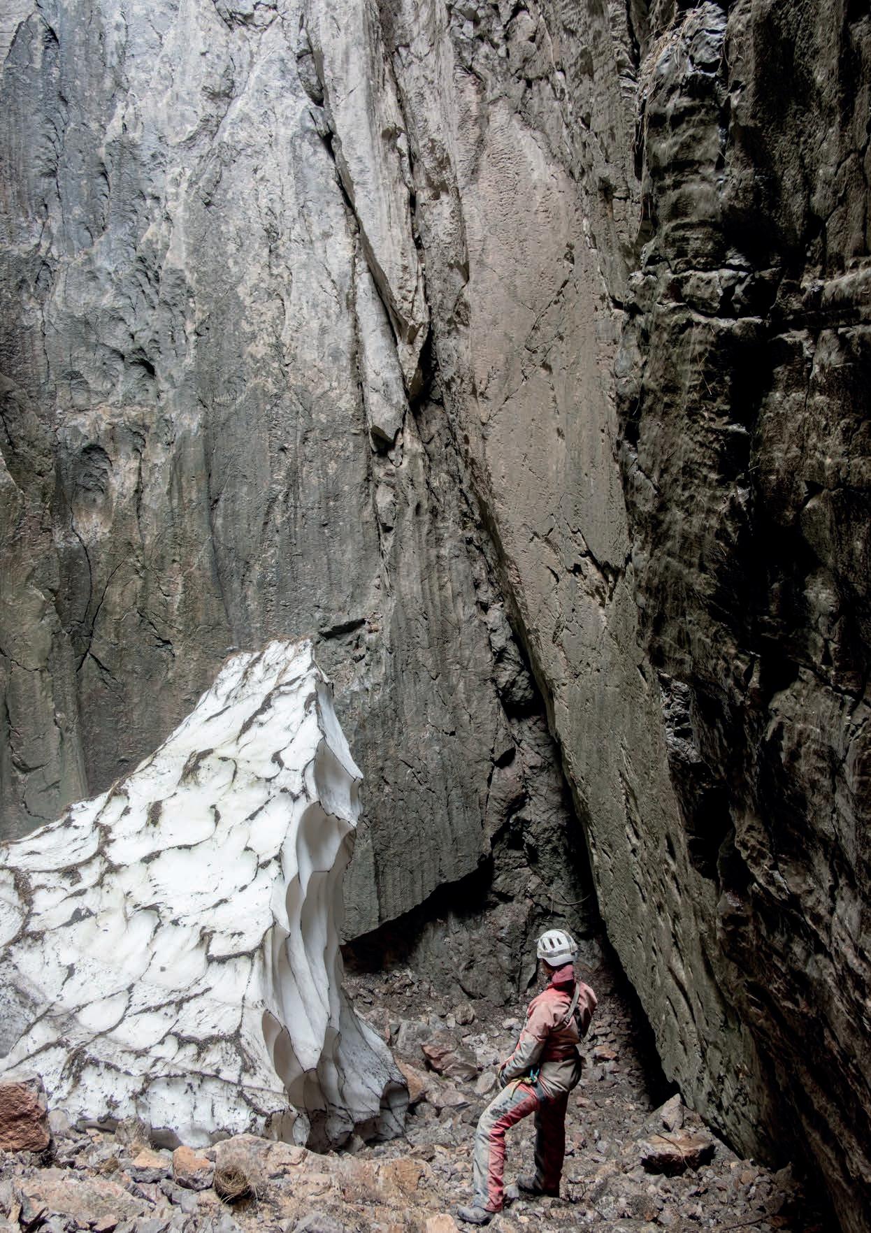
Accumulation of snow at the base of the shaft affording access to the Cave of Swallows
Balkan Peninsula