

Lambton Musings
LAMBTON’S HISTORY AND HERITAGE NEWSLETTER – SPRING 2024
All Aboard!
David McLean, The Forest Museumwww.discoveriesthatmatter.ca
Anyone involved in the museum “business” knows how important it is to stay relevant, engaging and interesting to visitors. They also know that providing sufficient space to accommodate our ever expanding collections is critical. With these two “needs” in mind, The Forest-Lambton Museum Society (FLMS) has decided to explore the possibilities of expanding our square footage with an addition to our building PLUS creating what it hopes will be a very “relevant, engaging and interesting” new feature…. What is this new feature? Read on to find out….
First, some background…. As you may know, Forest was founded thanks to the construction of the Grand Trunk Railway in 1859. In those days, locomotives were mainly wood burning, steam powered engines. With the (then) dense forests in our area, and the availability of water from Hickory Creek, this was a good place for locomotives to refuel. In short order, the railway stop attracted business interests and the community’s earliest settlers. It was the railway men who are credited with giving the settlement its simple, but very appropriate name. In the decades that followed the establishment of the Forest Grand Trunk Railway Station, the community grew and flourished. Numerous additional industries and businesses came into existence and close ties developed with the


Canning Factory – Forest, Ontario
surrounding farming population. In 1881, Forest surpassed all other municipalities in Lambton County in terms of the value of goods manufactured, and it soon became a major centre for the transport of local agricultural produce - including apples, peaches, grains and livestock - to destinations near and far. Located near the shores of Lake Huron, the railway also made Forest a major destination for travellers wishing to enjoy the beautiful sandy beaches just to its north, or to take in excursions aboard passenger steamships where entertainment was provided by the 27th Battalion or Forest Excelsior Bands. For over a century, the railway (taken over by CN in the 1920s) truly played a vital role in connecting the people and the business and agricultural interests of the area with the rest of the world.
Now, what the FLMS has in mind is to bring the history of Forest to life with the construction of a working model railway. Assisted by a newly formed group of model builders, our vision is to construct a 3D model representing the Town of Forest as it was in the 1950s, just as the steam locomotive era was nearing an end with the advent of diesel-powered engines. Incorporated into the model will be a fully functioning railway, iconic local buildings, and scenes depicting the lives of the residents of that period.
To make our vision a reality, we are seeking financial contributions from individuals, organizations and businesses. Contributions will directly support the purchase of materials such as tracks, trains, scenery, and interactive elements. Additionally, donations will help cover the costs of constructing the addition to our museum. We firmly believe that the Forest Model Railway Project will enhance our town’s cultural offerings, attract tourism, and foster a sense of pride among residents. Moreover, it will serve as a valuable educational resource for schools and community groups, providing unique hands-on learning opportunities. Our museum volunteers work hard to preserve and promote the area’s history, and we know that this initiative will do much to further our goals.
Any support, no matter the amount, will make a significant difference in realizing this project’s success. We are committed to recognizing our donors’ generosity through acknowledgements on our website, signage at the model railway site, and an invitation to the grand opening of the addition and the model railway. As a registered Canadian charity, The Forest Museum will issue tax receipts for all donations of $20 or more. More details regarding donor recognition will be coming soon.
If you would like more information about the Forest Model Railway Project or how you might contribute or get involved (we need more model builders!), please do not hesitate to contact us by phone or with an email message.
Phone: (519) 786-3239
Email: museum.forest@gmail.com
Corunna - Almost Canada’s Capital
Heritage St. Clair
In 1823, a survey party from England came to identify a suitable location for the capital of Canada. They arrived in awe of a mighty forest on the eastern shore of the St. Clair River. The site was named Corunna, to commemorate the Napoleonic battle of La Coruña, a seaport in northwestern Spain, where Lieutenant-General Sir John Moore died in battle.
The 1823 survey laid out the streets in a diagonal pattern similar to that of the British flag, the Union Jack. British army officers under the command of Sir John Moore provided the names for Corunna’s streets. Hill and Lyndoch Streets were to be the main thoroughfares of Canada’s capital, which accounts for their extra width, still seen today. The diagonal street design from the 1823 survey converged in the centre of a ten-acre open area which was named St. George’s Square, in honour of the patron saint of England. This is where the government buildings of the United Provinces of Upper Canada (now Ontario) and Lower Canada (now Quebec) would have been built.
A final survey was completed in 1837 eliminating the diagonal streets in favour of a square layout. The location of the proposed government buildings was to be St. George’s Square at the corner of Hill Street and Baird Street, where a monument now stands.
Sadly, the proposal to build Corunna as Canada’s capital was rejected, along with Toronto (York) and Kingston, because of their close proximity to the United States.
Settlement of the town began slowly and in 1852, a post office was established. Over time the village boasted two shoemakers, two harness makers, three blacksmiths, one cabinet maker, a tinsmith, a grist mill, a shipbuilder, two general stores, and several hotels. Shipping was an important mode of transportation at the time and many docks were built along Beresford Street to handle exports of timber, grain, and potash. In 1886, the Erie and Huron Railway, now known as CSX, was built through Corunna. This railway linked Corunna with Lake Huron, Sarnia, and as far south as Erieau on Lake Erie. In the 1890s, Stag Island was developed with resort hotels. This attracted tourists and vacationers and created an economic boost for Corunna.
With the establishment of Polymer in the 1940s, Canadian Oil and DuPont in the 1950s, and Petrosar in the 1970s, Corunna has become a thriving community.
St. George’s Square was intended as the town square but this plaza with the clock tower (built by Shell Canada and St. Clair Township) is now considered the centre of Corunna.


Corunna is now a thriving community that people continue to call home. We continue to celebrate our heritage by remembering that Corunna was almost Canada’s capital!
To learn more about Corunna, visit the monument at Hill Street and Baird Street and learn more here, https://www.stclairtownship.ca/heritage/
How the Oil Industry Helped Save the Whales
Liam Hurst, Oil Museum of Canada, Summer StudentOil is refined in many ways to create an enormous number of products that make our everyday lives comfortable, including various plastics, rubbers, fabrics, lubricants, and fuels. Something oil is not known for, however, is being environmentally friendly. Oil has had its moments though, and was an early major contributor towards “saving the whales” in the 19th century. Kerosene (made from petroleum) was a revolutionary product that dramatically improved the lives of people in the mid to late 1800s, but prior to its discovery, a common lighting fuel was whale oil.
Whales are the largest group of mammals in the world. They can range from 45 to 100 feet long and can weigh between 20 and 200 tons. Some whales are toothed whales, such as sperm whales and beluga whales. Others are baleen whales, such as blue whales and humpback whales, that use a filter-feeding system instead of teeth. Many whale species are endangered today and have been for centuries, but for different reasons. Throughout history, whales were overfished as technology, boats, and equipment improved and the whaling industry became a lucrative business. Today, the threats whales face are from shipping strikes, noise pollution, garbage, oil spills, and climate change.

Sperm Whales: A sperm whale with her calf. Sperm whales were most often hunted for their premium whale oil, spermaceti, found in an organ on their head used for echolocation and communication.
by Gabriel Barathieu on flickr.
PhotoWhaling, the act of hunting whales, traces back to countries like Norway and Japan over 4,000 years ago (or even earlier). Every part of the whale was consumed or used. Some countries continue to hunt whales for clothing, food, fishing lines, baskets, and lighting lanterns, although the demand has greatly decreased.
Whale oil used in lamps did have drawbacks, which became especially apparent as the demand for lighting became greater. It was less efficient than kerosene and did not burn as bright or as clean. Whale oil was also quite difficult and dangerous to obtain even if you lived along the ocean coasts. This made whale oil quite expensive compared to kerosene. Though whale oil was the standard for its time, it was ultimately replaced by kerosene.
It was in 1846 when Abraham Gesner, a Nova Scotian, developed a process to refine a liquid crude from coal and shale. He called it kerosene. Gesner found it had amazing potential as a substitute for whale oil as a lighting fluid, as it burned much cleaner and brighter and was less dangerous to procure and easier to produce. Although shale oil’s use wasn’t immediately widespread, in 1858, James Miller Williams showed that kerosene could also be refined from petroleum, which was in abundance in Oil Springs and soon the United States. In addition to Gesner’s kerosene benefits, petroleum kerosene was also cheap and accessible. With all these benefits, petroleum almost instantly and completely replaced whale oil in its job of lighting lamps by the end of 1859.
The oil industry and the widespread use of kerosene for lanterns can be credited for playing a big role in preventing the overhunting and possible extinction of the whale population. However, whales are still listed as endangered species in the wild. We all need to do our part in the protection and restoration of our worldwide environment and wildlife.

Whale oil lamp: Whale oil was produced by boiling whale fat and blubber. Once the oil was prepared, it was poured into the container at the top of the lamp’s handle. Oil Museum of Canada’s collection.

Kerosene Lamp: Because kerosene burned cleaner than many other fuel sources, it was deemed safe for use inside homes and still burned much brighter and more efficiently than its other competitors which were also safe for inside use. Oil Museum of Canada’s collection.
A 200-Year-Old Mystery
Colleen Inglis, Lambton Heritage Museum“We had quite a time imagining what it might mean. I was thrilled and my imagination worked overtime.”


 ~Muriel (Hillier) Frame
In the early 1920s, young Muriel May Hillier was playing along a creek bed in what is now Sarnia’s north end. She found a very intriguing object. It was a small lead sheet with a faded message carved into it. With the help of her companions, she deciphered the message on the spot. Over 50 years later, in 1979, Muriel (Hillier) Frame donated the lead sheet to Lambton Heritage Museum. Museum staff have puzzled over this mysterious object ever since.
In the 1920s, the area where the lead sheet was found was home to Camp Wawanda and Lake Huron Park. Today this is a residential part of Sarnia near Lakeshore Road and McMillen Parkway. According to Frame, “We hiked through there a lot, it was all bush at the time. The creek was dry and I sat down under this old tree. I was just poking around when I saw the lead sheet up under an old root.” Lake Huron Park marked the northern end of the Sarnia Street Railway. It linked downtown Sarnia to the beach.
An Unusual Object
Lead sheets were used to make ammunition for muskets and rifles from the 1600s to 1800s. A one-inch square piece was cut from the sheet, melted over a hot fire, poured into a shot mold, and allowed to cool. This resulted in a round piece of lead shot. The lead sheet found by Frame is 10 cm x 13 cm. It has one corner missing, likely enough for one piece of shot. The process was time-consuming but necessary for soldiers or hunters that lived in the bush.

Pincer-style bullet mold from Lambton Heritage
Lead sheet with cryptic message from Lambton Heritage Museum collection. Sarnia Street Railway at Lake Huron Park. Image courtesy Lambton Heritage Museum collection. Shot from Lambton Heritage Museum collection. Museum collection.The words carved on the lead sheet are hard to read. Taking a rubbing of the message makes the letters clearer. One interpretation is shown here:
The ‘S’ in “SO” could also be a ‘J’ for “JO.” This changes the interpretation to: “Tealuck shot Jo. If they get me, take Mary to York.” The message stirs up many questions. Why was someone shot? Who is Mary? Who did G.R. Reed Car. think was out to get him, and why? To date, research has failed to connect the names Tealuck, Mary, Jo, and G.R. Reed Car.

Lead sheet with message deciphered from rubbing.
The 1791 date is tricky to decipher. None of the modern towns and cities of Lambton County existed then. The Anishinaabe, soldiers, explorers, traders, missionaries, and a few settlers lived in a relative wilderness and travelled along waterways, portage routes, and trails. Little documentation survives to tell their stories. Few European settlers were recorded in Lambton County until the 1830s. The 1851 Census of Canada is the earliest census that is widely available. In spite of limited resources, it is still possible to piece together a blurry picture of Lambton County in the late 1700s.
Lambton County in 1791
First Nations have gathered for thousands of years where Lake Huron flows into the St. Clair River. French explorers and traders arrived in the early 1600s. René Robert Cavelier, Sieur de La Salle, sailed on the Griffon through the St. Clair River in 1679. In 1686, French explorer Daniel Greysolon, Sieur du Lhut, built Fort St. Joseph on the St. Clair River to bar English traders from the upper Great Lakes. The fort was abandoned in 1688. Its exact location is unknown. In the 1700s, the village of Petagwano stood where Point Edward is today. Port Huron was settled about 1790.

Further afield, Fort Detroit was founded by the French in 1701 as a trading post. Petite Côte was settled by 1747 at Windsor. Fort Detroit was taken over by the British in 1763. It was a strategic intelligence post and provisions depot during the American Revolutionary War (1775-1783). It remained in British hands, along with other forts including Fort Niagara and Fort Mackinac, until 1795. In 1796, the British established the towns of Amherstburg and Sandwich.
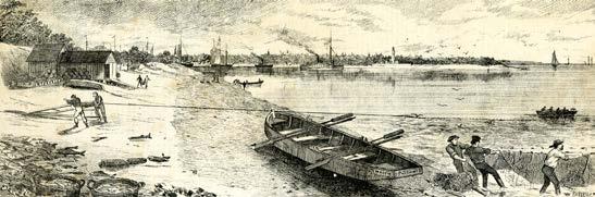
Fishing grounds at the mouth of Lake Huron, looking west to Port Huron. From the Canadian Illustrated News, January 1, 1876.
Fort Detroit in 1701.How Did It Get Here?
How does the mysterious lead sheet connect to this early history? Did donor Muriel Frame find the lead sheet where the message was originally dropped? It was discovered nestled within the roots of a tree along a creek. Could it have been created elsewhere and then carried to this area by the waves of Lake Huron?
A final consideration is whether the object is authentic. Does it really date to 1791? Is the message deciphered correctly? Is it something else entirely, such as an elaborate prop in game played by vacationers at the lake in the 1800s or early 1900s? There is a lot to speculate. Unless a new clue is found, we may never know. No doubt the lead sheet will continue to intrigue visitors and staff for years to come.
Windows of the Past: Historic Buildings
Lambton County Archives Staff
Historic buildings can tell us fascinating stories about architecture, businesses, and people from across Lambton County. They foster a collective memory about the social, economic, and aesthetic tastes of earlier generations. One story takes us to the Municipality of Brooke Alvinston and Lochner’s Barbershop in Inwood. It was once located on James Street next to the Inwood Library.

The small brick building was originally built by Lucius D. Brown in 1899 after the Inwood fire of 1898. It was used as a barbershop since its construction. Ernie Lochner purchased the building after Lucius’ death in 1931. He continued to operate the business along with his son, Howard, who eventually took over the building in 1964.
Even at the end of its life, a stroll through the barbershop was like stepping through time. The interior was kept in its original state, with bottles lining the shelves which were over 50 years old in some cases. Nine grey, wooden chairs sat in a line waiting for customers and a collection of stuffed birds decorated the wall above them. A stuffed bobcat watched customers from a far corner.
A poolroom was added off the back in 1946 but the barbershop remained the heart of Inwood’s social life. Back when haircuts cost 15 cents, customers would pack the shop and share gossip of the day. Howard commented in a London Free Press article (January 9, 1984), “We’ve had reeves and deputy reeves and councilors in here all at once… there’s been a few decisions made in here.” The Lochner Barbershop kept the citizens of Inwood well-trimmed until Howard closed the shop in 1985.
Life of a Building – The Basswood Block
Moore Museum Staff
Ask about the history of a building and most people will tell you of the families, businesses or things that moved in and out over time. But there was a time the buildings themselves were moved, and this became part of their story.
Such is the case with one of the buildings on Moore Museum’s grounds. The Basswood Block was built in Oil Springs in the mid-1800s, as “oil fever” took over the area. While oil had been used in the area for hundreds of years, it was discovered to burn fairly well, and drillers from other areas began to purchase tracts of nearby land to survey into smaller lots for rent. After the discovery of “Shaw’s Well”, which produced large amounts of oil in an almost uncontrollable flow, the word only spread faster. Momentum was given to all kinds of businesses and Oil Springs soon had stores, hotels, refineries, copper shops, and more. While the local oil industry experienced its ups and downs, hotels and boarding houses made small fortunes, and the Basswood Block became part of this industry town.
In the 1870s, the building was moved from Oil Springs to Brigden, which was experiencing its own growth spurt at the time. The town’s founder, Nathaniel Boswell, came to the area and built a sawmill, flour mill, and blacksmith shop, among other things. This was enticing to would-be settlers. The growth was also due to the railroad tracks laid by William Brigden, the town’s namesake, who laid the track in anticipation of a new railway line from St. Thomas to the St. Clair River. The railway would bring an economic boom to Brigden, and all the things that go with it. So it was around this time that the Basswood Block made the 16km move to Brigden. This was done in the winter months when the building slid more easily over the frozen ground. The building found its new home on the main street and in the several decades it remained there, it housed a variety of businesses in its
 Main street in Brigden, early 1900s. In the forefront is John Armstrong’s Store, and in the background, the Basswood Block.
four window shops. In the early 1900s there was W.J. Grey’s tailor shop, Hackney’s barbershop, a township clerk’s office, and a tin shop. The tin shop was owned by George Rogers, and a copper boiler and sap buckets made there can be found at the museum today.


Later, the building was purchased by Frank Carroll. He constructed a second floor that would house a roller rink and dance hall. While fun for the participants, it was said that the skating sounded like a loud thunderstorm to the tenants below. Locally known as “Carroll’s Hall”, the building hosted large bands, including Guy Lumbardo and His Royal Canadians. It was home to Bridgen Fair dances on several occasions, and even showed movies for local school children.
Eventually, the building came to be owned by the Steadman Brothers who used it to house their furniture store and funeral home. In 1991, when the building was to be torn down, the Steadman’s offered to have Moore Museum come and salvage what they could of the façade and any other materials. Over the next seven years, the building was taken apart, moved to the museum grounds, reconstructed, and refurbished. Volunteers were able to reconstruct the Basswood Block with enough materials from the original to create three storefronts, instead of the original four.
Advertisement for David Hackney, Barber. J.R. Adams Jewelry Store, also once located in the Basswood Block.
The Basswood Block is taken down by volunteers, hoping to salvage enough materials to rebuild it at Moore Museum.

The Basswood Block, restored to its former glory and opened on the Museum grounds in 1998.
Today, the Basswood Block is home to a print shop, harness shop, and carpentry shop and is visited by thousands of people each year. Tools, instruments, and furniture from local businesses long gone fill these shops and help tell the story of this well-travelled building.

The Good Old Days - The Bad Old Days
Alan Campbell, Facilitator and Newsletter Editor, Lambton County Branch of The Ontario Genealogical SocietyPreparing a query related to an Austin Harvey led me to exploring his family. The query was related to trying to get an historical object, a brick with Austin’s name inscribed on it, to a surviving member of the family, so I did a deep dive into the family. What I found was a record of the worst and the best that could happen to a family.

Austin Blake Harvey was the son of Dr. Albert Edward Harvey and Jennie McLure of Wyoming, Ontario. Austin, a medical student at the time, died 16 April 1907 at the age of 21 due to tuberculosis and his remains were buried in Wyoming Cemetery, Wyoming, Ontario. This was not the only tragedy to strike the family.
Austin’s father, Dr. Albert Edward Harvey, son of Andrew and Abigail Harvey, married Margaret Willis, daughter of Robert and Mary Willis, 11 November 1869. Margaret gave birth to Rosa Harvey in 1871. Orlando Harvey was born 1 July 1872 at Wyoming but tragically died the following year on 30 January 1873. Margaret [Willis] died 20 October 1873 at Plympton Township at the age of 23 [21 years 16 days according to her cemetery stone] due to dysentery. Albert was probably devastated.
Albert married Catherine McLure, daughter of John McLure and Rosanna Smith, 14 October 1874 at Wyoming. A Maggie [Margaret] born circa 1875 was enumerated in the 1891 Canada Census. No birth record was found for her. More tragedy entered the family’s life when Catherine died 9 May 1878 due to an overdose of morphine.
Albert married Jane McClure, sister of Catherine, 14 May 1879 at Wyoming. Jane gave her residence as Wyoming at the time of the marriage, perhaps she had been helping Albert with his family. Sarah Alice Harvey was born 3 March 1880 at Wyoming. Rufus William Harvey was born 7 April 1881 at Wyoming. Kitty Louella May Harvey was born 26 September 1883 at Wyoming. Hers was to be a short life as she died 16 February 1884 of bronchitis. Compounding this loss was the premature birth of an unnamed male child 9 June 1884 who died the same day. Austin Blake Harvey was born circa 1886, a birth registration for him has been elusive. Jean Evelyn Harvey was born 9 September 1893 at Wyoming. Her birth registration has proved to be elusive as well. This birth date was taken from her death registration.
The first decade of the 1900s was not good to the family. Rufus William Harvey died 9 May 1901 at the age of 20 due to pulmonary tuberculosis. He was single and a student at the time. Dr. Harvey died 27 May 1905, at the age of 64, due to apoplexy. His death was followed by that of Austin Blake Harvey as noted above, another death due to tuberculosis. He was a medical student at the time of his death. The bright spots during this time were the marriage of Margaret to James Thomson Shotwell, son of John B. Shotwell and Ann Dewar, at Wyoming 28 August 1901 and Sarah Alice’s marriage to Raymond Smith Baker 17 August 1904 at Wyoming.
Jane [Jennie] (McLure) Harvey died 22 August 1914 at the age of 60 at Victoria, British Columbia. Rosa, a music teacher, single, died 21 July 1943 at London, Ontario. Sarah and Raymond moved to British Columbia where she died 13 April 1956 at Victoria. No offspring were found with the couple in censuses and birth records for that period have not yet been released. Jean Evelyn Harvey, a teacher, died 8 April 1959 at Victoria, British Columbia as a single woman. She was enumerated living with her sister Sarah in the 1921 Canada Census at 1133 Leonard St., Victoria and on Cordora Bay Road, in Nanaimo District, British Columbia in the 1931 Canada Census. Margaret and James Shotwell moved to New York State where she was a portrait artist and he an historian and scholar. They had two children; Margaret S. (Shotwell) Summers and Helen Harvey Shotwell. A granddaughter is mentioned in Margaret’s obituary so this line may have continued through the Shotwells. Margaret died 8 July 1965, at the age of 91, at New York City.
As most families do, the Harvey family experienced both the good old days and the bad old days - perhaps more so in terms of the latter.
If a family member is interested in a copy of this family history with full source citations please contact me at lambtonnewsletters@ogs.on.ca. If a family member is interested in the brick please contact Jerry at vanwykjerry@gmail.com.
Lambton County Branch Website
Do check out the landing page of our website at https://lambton.ogs.on.ca Lots of interesting information can be found there as well as master index to our resources and the family histories held by the Lambton County Archives.
Lambton County Branch Facebook Group
Check out our Facebook Group as well at https://www.facebook.com/groups/918188561527694


Heritage Sarnia-Lambton Members
Moore Museum
94 Moore Line, Mooretown, ON N0N 1M0 519-867-2020 mooremuseum.ca facebook.com/mooremuseum
Plympton-Wyoming Museum
6745 Camlachie Road, Camlachie, ON N0N 1E0 plymptonwyomingmuseum.ca
facebook.com/Plympton-Wyoming-Historical-Society-286687844815040
Lambton Heritage Museum
10035 Museum Road, Grand Bend, ON N0M 1T0 519-243-2600 heritagemuseum.ca facebook.com/lambtonheritagemuseum
Oil Museum of Canada
2423 Kelly Road, Oil Springs, ON N0N 1P0 519-834-2840 oilmuseum.ca facebook.com/oilmuseumofcanada
Arkona Lions Museum and Information Centre
8685 Rock Glen Road, Arkona, ON N0M 1B0 519-828-3071
abca.ca/conservationareas/rockglen/ facebook.com/arkonalionsmuseum/
Sombra Museum
3476 St. Clair Parkway, Sombra, ON N0P 2H0
519-892-3982 sombramuseum.webs.com facebook.com/sombramuseum
Lambton County Archives
787 Broadway Street, Wyoming, ON N0N 1T0 519-845-5426 lambtonarchives.ca facebook.com/lambtoncountyarchives
Forest-Lambton Museum
8 Main St. North, Forest, ON N0N 1J0 forestlambtonmuseum.ca facebook.com/ForestLambtonMuseum
Additional Contributors
The Ontario Genealogical Society, Lambton Branch lambton.ogs.on.ca facebook.com/groups/LambtonBranchOGS
Hertiage St. Clair
https://www.stclairtownship.ca/heritage/