
Rethinking Open
Space new regulations guided by the 2018 comprehensive plan Revised Draft Text Planning Commission Work Session September 15, 2022 Valerie Friedmann, LFUCG Senior Planner & Greenspace Planner, Long Range Planning vfriedmann@lexingtonky.gov Check out the open space project page for the latest information and full draft text.

The Incorporategoal:intentionally designed and equitably distributed open space and green space into all development projects. Not more quantity, just better quality.
2 years+

NationalPracticesBest LexingtonContext PeerReviewCity LEED andNationalDevelopmentNeighborhoodGuideRecreationParkAssociationTrustforPublicLandUrbanLandInstitute
Charlotte, ColoradoChattanooga,NCTNCincinnati,OHSprings,CODurham,NCFortCollins,COFortWayne,INFranklin,TNGreensboro,NCHenderson,NVIndianapolis,IN Kansas City, MO Lincoln, VirginiaMinneapolis,Louisville,NEKYMadison,WIMNNashville,TNNorfolk,VARaleigh,NCSt.Louis,MOSt.Paul,MNBeach,VA

Planning Commission Work Session
Development and Design Focus Group Session 2
Greenspace Commission
organizationswithmeetings20+publicgroups,&stakeholders
Parks and Recreation Leadership
Planning Staff Interim Review
Fayette Alliance Board
Environmental Commission
Parks Advisory Board
Infill & Redevelopment Steering Committee
Commission Work Session
Development and Design Community
Stormwater Stakeholder Committee
Parks Advisory Board
Greenspace Commission
Parks Advisory Board
PlanningFCNC
Development and Design Focus Group Session 1
2022 Trust for Public Land
2021 PublicBIA Input Session
Infill & Redevelopment Steering Committee
2020 Planning Commission Work Session
Erin Masterson, PLA, ASLA
Gresham Smith
EA Partners
Greg Smorstad, PLA
Jason Hale, PLA, LEED AP
Design and ProfessionalsEngineering
2 workshopsgroupfocus
Earthcycle Design
Banks Engineering
Scott Southall, PLA, AICP, LEED AP BD+C, ASLA
Matt Carter, P.E.
Barrett Partners
Vision Engineering
Tony Barrett, PLA, LEED AP
CARMAN
Rory Kahly, PLA
Kevin Warner, PLA
DivisionswithCoordinationother Planning Parks & Rec EnvironmentalServices Bike Pedestrian&
Trust for Public LandParkandMinute CommitmentWalk
Greenspace Access and Equity Accelerator 10


On the Table 2022 Public Input

TOP 10 CODES BY THEME

4 WorkCommissionPlanningSessions
Theme A: Growing successful neighborhoods Goal 2: Support infill and redevelopment throughout the Urban Service Area as a strategic component of growth. Incorporate adequate greenspace and open space into all development projects, which serve the needs of the intended population.
Comprehensive Plan Goals and Objectives

POLICY #4: ACCESSIBLE GREENSPACE
Comprehensive Plan Policies
Provide adequate greenspace for all neighborhoods within walking distance.
Theme B: Protecting the SUSTAINABILITYEnvironment
PROVIDEDESIGNNeighborhoodsPOLICY#9:ADEQUATE GREENSPACE
Action Item:
Amend zoning ordinance to redefine open space requirements.
Make recommendations to locate new development within walking distance of existing greenspace / community centers, or create greenspace / community centers within walking distance of residential uses.
Theme A: Growing Successful
Existing Open Space Requirements
• Zoning Ordinance contains ~170 mentions of “open space” • Scattered requirements across multiple zones/articles • Ambiguous definition is unfocused, difficult to interpret and measure • Lacking direction for open space to provide ecological benefits • No requirement accessible/walkablefor open space • Standards don’t apply in some areas where they should

Existing Standards: “Minimum Useable Open Space”

Existing Open Space Requirements
• Zoning Ordinance contains ~170 mentions of “open space” • Scattered requirements across multiple zones/articles • Ambiguous definition is unfocused, difficult to interpret and measure • Lacking direction for open space to provide ecological benefits • No requirement for accessible/walkable open space • Standards don’t apply in some areas where they should
OPENExisitingdefinitionSPACE,USEABLE
- Outdoor area of a lot or tract which is designated and used for outdoor living, recreation, pedestrian access or planting. Such areas may be ground or roof space seventyfive percent (75%) open to the sky, balconies a minimum of five (5) feet wide, an enclosed deck, porch, or ground floor portions of a building constructed on columns. Off-street parking and loading areas, driveways, vehicular use area perimeter landscaping and interior landscaping, unenclosed fire escapes, or required front and side street side yard areas do not qualify as useable open space; provided, however, that those portions of the required side street side yard may qualify as useable open space, as long as such open space is separated from the street right-of-way by a fence or solid screen planting.
An example • R-5 Group residential • 5.6 acres • 385 dwelling units • Minimum useable open space • Required: 10% • Provided: ~20%


Existing Open Space Requirements
• Zoning Ordinance contains ~170 mentions of “open space” • Scattered requirements across multiple zones/articles • Ambiguous definition is unfocused, difficult to interpret and measure • Lacking direction for open space to provide ecological benefits • No requirement accessible/walkablefor open space • Standards don’t apply in some areas where they should


Four main issues with existing text Definition is unfocused. Regulations are scattered across individual zones. Current requirements do not ensure common areas planned for use by people; not incentivizing environmental landscaping. 1. Inefficient 2. Multi-family Our single family residential developments deserve access to neighborhood-serving open space, too. 3. Single Family We need consistency across all zones; incentives to address stormwater and heat island effects. 4. Commercial/Industrial
Article 20: Open Space Standards


“Reserved for Future Use” Standards for Open Space (5 pages)


Article 1: Definitions • Green Infrastructure (new) • Open space, useable (deleted) • Open space (new) • Common area (new) • Useable area (new) • Vegetated area (new) • Walkable Route (new) Useable Areas Common VegetatedAreasAreas

• Support the Urban County Government’s goal of providing access to open space within a 10-minute walk of all neighborhoods and communities.
• Protect and enhance public health, safety, and quality of life by providing safe and accessible open space where people can gather and establish a sense of community.
Sec 20-1. Intent.
The intent of this Article is to incorporate intentionally designed and equitably distributed open space into all development projects.
The regulations contained in this provision are intended to:
• Increase environmental sustainability and resiliency by providing green space to offset the impacts of the built environment.

Useable Areas Common VegetatedAreasAreas
Sec 20-2.
Overlap in use and purpose of open space types. Open Space Requirements.
Intentionally
(i.e. balconies, patios, walkways) Vegetated


Existing or new vegetation.
Common AreaUseable Area living and pedestrian access Area planned for gathering.

outdoor
Outdoor
Sec 20-2. Open Space Requirements. Summary table of open space requirements. SingleFamilyResidential Useable Area (See Article 1) Vegetated Area (See Articles 1, 20-3 to 20-4) (SeeCommonArea(s)Articles1,20-5 to 20-8) R-1A, R-1B, R-1C, R-1D, R-1E, R-1T, R-2,R-3,R-4,M-1P Not required. Not required. Required for > 25 dwelling units Multi-Family Residential / Group Residential Projects Useable Area Vegetated Area CommonArea(s) R-1T 10% 10% Required for > 25 dwelling unitsR-3 20% 20% R-4 15% 15% R-5 10% 10% Mixed Use / Commercial Useable Area Vegetated Area CommonArea(s) B-1,P-1,B-3,B-4,B-5P,MU-1,MU-2,I-1,I-2 10% 10% Required for sites >3 net acres and/or > 25 dwelling unitsB-2,B-2A, B-2B 5% 5% B-6P, MU-3 15% 15% P-2 40% 20%
Zone Existing Proposed Change CommonArea1 SingleResidentialFamily R-1A, R-1B, R-1C, R-1D, R-1E, R-1T, R-2, R-3, R-4, M-1P 0% 0% - R-1T (subdivided) 10% 2 0% ↓ Multi-Family&GroupResidential R 1T (group) 20% 10% ↓ R-3 20% 20% -- R 4 20% 15% ↓ R-5 20% 10% ↓ CommercialConsumer&Service B-1 0% 3 10% ↑ P-1 0% 3 10% ↑ B-3 0% 10% ↑ B-5P 0% 10% ↑ B 6P 15% 15% MU-1 10% 10% -- Industry Employment& B-4 0% 10% ↑ I-1 0% 10% ↑ I-2 0% 10% ↑ P-2 40% 40% Downtown B-2 0%/10% 4 5% ↑↓ B-2A 0%/10% 4 5% ↑↓ B 2B 0%/10% 3 5% ↑↓ MU-2 10% 10% -- MU-3 15% 15% -- Existing / Proposed Open Space Required Everyone deserves access within a 10-Minute Walk Less in exchange for better. Baseline consistency across all zones, address stormwater and heat island effects. Ease of use, improvements in quality and access. 1 When DU/Size threshold met; 2 Private useable open space; 3 10% of lot where residences provided; 4 10% of residential floor area

Sec 20-3. Vegetated Area Requirements.Standards. • 75% ground coverage • Excludes required vehicular use area interior landscaping (but includes VUA perimeter landscaping) • Excludes invasive tree and plant species • Clear instructions for different Development Plans
Sites 3 acres or less can provide green infrastructure to reduce required vegetated area. Green Infrastructure Type RateMultiplier Innovative Design 1 1.15 Community Garden 2 1.15 Tree Stand 3 1.5 Vegetated Green Infrastructure 4 1.75 Vegetated Roof 4 2 Riparian Buffer Restoration/Preservation 5 2 Tree Preservation Area 6 2 Sec 20-4. Vegetated Area Incentives for Green Infrastructure.

Sec 20-5. Common Area LocationStandards.Criteria • 10 minute walk to 90% of entrances • Connected to other open spaces

Sec 20-5. Common Area -DevelopmentStandards.StandardsHealth,Safety,Welfare1. Primary access and visibility 2. Secondary entry points 3. Physical improvements 4. Canopy coverage and shading 5. Topography and hydrology

Sec 20-5. Common Area Standards. Single Family Context 10,000sf, 100’ minimum width 8,500 SF8,500 connectedSF by walkable route 8,500 SF Multi-family / Mixed-use / Commercial Context 8,500sf, 20’ minimum width 10,000 SF


Sec. 20-6. Common area exemption for development near publically accessible open spaces. Common areas not required in the following instances: 1. ½ mile walk of an entrance to a LFUCG park 2. ¼ mile walk of an entrance to a portion of a greenway which meets common area requirements 3. ¼ mile walk of an entrance to another existing publicly accessible open space which meets common area requirements

Sec. 20-7. Common area signage and shared use path access. Signage • Incidental signs - hours of operation, maintenance contact • May reference KRS 411.190 - limits owner’s liability when land is used for recreational purposes Shared use path access • Appropriate easement shall be provided • Access shall be available 24/7

Sec. 20-8. developmentsMultiphaseandtiming. • Common area(s) calculated based on total development • Build common area in phase one or subsequent phases • Commercial, industrial, and mixed use development: common areas / improvements by 50% buildout • Residential development: common areas / improvements by 50% dwelling units constructed

Sec. 23A. Expansion Area Zones. EAR-1 / EAR-2 / EAR-3 / CC / ED 25% of the net developable acreage shall be open space. (existing) New: Common open space access point every 1/4 mile. Access points minimum of 40’ wide with a 5’ sidewalk.


Orenco Hillsboro,StationOregon

Primary access and visibility Physical improvements Canopy coverage and shading Topography and hydrology

Orenco Hillsboro,StationOregon48ac330dwelling units


Spring Lake - 2300 Sandersville Road Statistics • 140 ac total • R-3 / R-4 • 17 ac ROW Single Family Lots • 322 units • 46 ac • 50’-120’/130’ Townhouseslots • 35 units • 8.5 Apartmentsac • 378 units • 37 ac total • 8.1 ac open space (22%) Remaining Open Space • ~31 ac 10,000 SF


DogwoodwalkPartiallyCamicPropertywithin½mileofanentrancetoPark


StatisticsCamicProperty


• 15 ac total • R-3 • 2.9 ac ROW Single Family Lots • 88 units • 9.8 ac • 40’x120’ SpaceRemaininglotsOpen • 2.3 ac ½ mile walk to park 12,900 sf 10,000 SF

Oak Dale – 1201 Greendale12,650Road20,850sfsf sf8,500 Statistics • 9.5 ac total • B-6P • .7 ac ApartmentsROW • 144 units • 7 ac Commercialtotal • 1.8 OpenacSpace • 1.8 ac provided (20%) • 15% required 8,500 8,500SF connectedSF by walkable route 8,500 SF


Blackburn
Avenue

Fully within ½ mile walk of an entrance to Coolavin Park
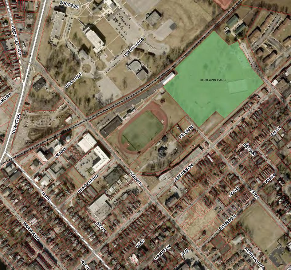
Blackburn Avenue Statistics • 2.37 ac total • ApartmentsR-5 • 108 units Open Space • .61 ac provided (25.7%) • 20% required 5,800 sf 4,000 sf 8,500 8,500SF connectedSF by walkable route 8,500 SF

• The Open Space ZOTA works in tandem with the Parking ZOTA (reducing parking requirements) and the F.A.R. ZOTA (increased density) • The three things that constitute a site: building footprint, parking areas, and open space • Parking ZOTA and F.A.R. ZOTA make more room for development…in exchange for more purposeful open and green spaces FootprintBuilding Vehicle Use SpaceOpenAreas Coordinated Regulation Updates

The Developers Need Reform
Community AND
• Our focus throughout implementation of Imagine Lexington has been to unlock higher utilization of existing land • That land is very expensive • Two primary constraints: • Address the needs/wants of the community • Ensure that developers have the tools to meet those needs AND make a profit
Next in November Planning Commission
Hearing
steps • File
October • October Work Session (if needed) • November Committee Meetings • Goal -
Questions & Comments? Send an email to be added to the notification list for this ZOTA, or check out the project page for the latest information—including a link to our feedback form. https://imaginelexington.com/ZOTA_Openvfriedmann@lexingtonky.gov-Space
