

� 0 <!) .,. ;;; 0 <!) Ill :, e <!) Prime Farmland and Statewide Important Soils ......__,, �,_ ....__ v;;-...., ,s-<9-?,..�'-'e All areas are prime farmland "I')�'........ Farmland of statewide importance .., , �-__1-· Urban Service Area '�--............. .... .,, A #..---'\.� .,;{.,.,..,....,.. \ \ ,,,,c_.,,/----- . N A So�C "co----��,,�,, \ \ 'l""I\�."(! tr \' \ /'-"'()·(· , \ / I I,,''/j l� >) \ \ .'--J'°) �?' . ;: _., ,, ,.r-pp'-� 'h LEXINGTON Thisproducttsproducedanddtstr1buted�: LeMlngton•f'ayetteUrbanc.ountyGovern.ment GlSse,ctionlOICVin<!St,Sthf1ooi LexingtOn,tcY40S07. Notlo,-(�. 1\111nr01rnotlononthisPJoduct1$�!cved aa:urnte,but1-snotg,uaranc:eedwithoute1Tor, Nopartofthispubllc.atlonmaybereproduced, stored,Of'transmtttedInanyform,Of'byany meanswit.hootwrittenpermlsstonfromLIUC:G. 02022lfUCG i:-:._ _.


Environmental Considerations Harp s ForkCreek GooseCreek GooseCreek North Elkh o r n Creek AvonBranch AvonBranch Cane Run TownBranch CaneRun TownBranch Steeles Run ManchesterB ranch South Elkh orn C r eek ShannonRun Cave Creek Vaughn'sBranch WolfRun ClemensRun SouthElkhornCreek DavisFork David Creek N o r t h E l kh o r n Creek B r y a n StationCree k MaryReynoldsCreek JonesCreek B o eno C r eek Downi n gTributary Wilson MillCreekWestHickman Creek East H c k m na keerC Baughman Fork Shelby Branch Boggs Fork ElkLick Creek Raven Run MarbleCreek Kentuck y River Q Q I I I I I I ! ! I I ! ! I t I t North Elkhorn Creek Old Frankfort Pike South Elkhorn Creek Boone Creek Kentucky River ® 0 2 1 Miles Water Network Water Body FEMA Floodplain 2014 Designated Focus Area Environmentally Sensitive Area Natural Protection Areas Royal Spring Wellhead Protection Area Watershed Boone Creek Cane Run East Hickman Kentucky River North Elkhorn South Elkhorn Town Branch West Hickman Wolf Run This product is produced and distributed by: Lexington Fayette Urban County Government GIS Section 200 E Main St 7th Floor Lexington, KY 40507. Not for resale. All information on this product is believed accurate but is not guaranteed without error. No part of this publication may be reproduced, stored or transmitted in any form or by any means without written permission from LFUCG. © 2022 LFUCG Exported 2022.11.29 Document Path: T:\pro_docs\PDR\RLM\Geo_RuralLandMgmt\
Lexington's Rural Service Area
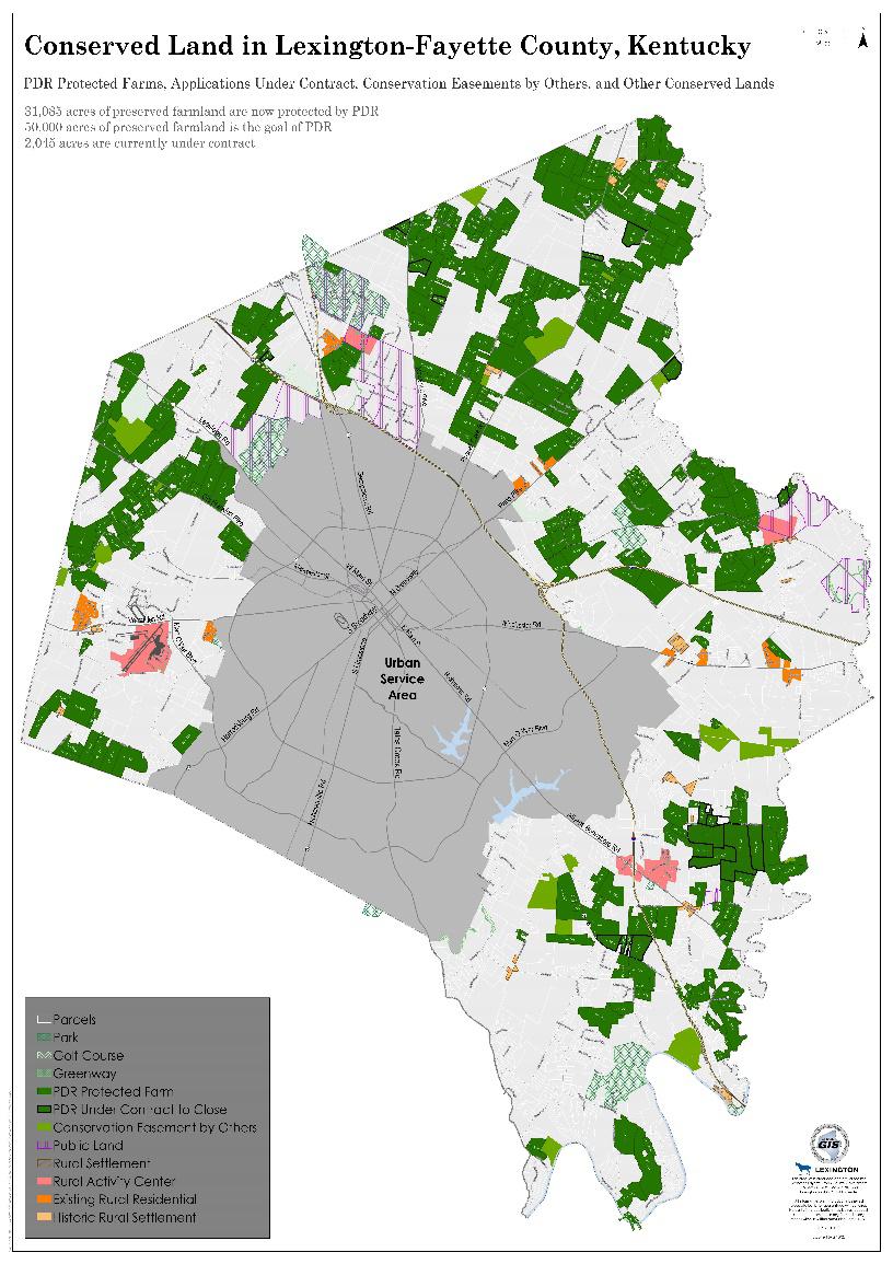
Conserved Land in Lexington-Fayette County, Kentucky
PDR Protected Farms, Applications Under Contract, Conservation Easements by Others, and Other Conserved Lands
31,085 acres of preserved farmland are now protected by PDR 50,000 acres of preserved farmland is the goal of PDR 2,045 acres are currently under contract
Parcels Park
Golf Course

Greenway
PDR Protected Farm
PDR Under Contract to Close
Conservation Easement by Others

Public Land
Rural Settlement
Rural Activity Center
Existing Rural Residential Historic Rural Settlement
Q Q I I I I I I ! ! I I ! ! I t I t Versailles Rd HarrodsburgRd Nicholasville Rd OldFrankfortPike Manchester St LeestownRd RichmondRd WMainSt EMainSt Geo rgetown Rd Newtown Pike Russell CaveRd SBroadway NBroadway ParisPike Winchester Rd S Limestone ManOWar Blvd AthensBoonsboroRd Tates Creek Rd Man OWarBlvd B SkyP wy Ca b ka e D Silks Ln B ckG te D RceRd ck C e Pike LeestownRd DoeRunTrl eea R Spy CoastLn e M d G mb d BeachRd VanMeterRd a ie R d W mor an d eege L E te a nm nt C Versailles ManOWarBlvd FriscoDr A po Rd Cigar Ln O en W y CarterbrookLn Old o Wok Rd Beb p y Alexandria Dr OdRchmo dRd BueR bb Ahen BoonebooRd Mu S t Rd IronWorksPike O d e Rd JohnstonRd WalmacLn R hP kD HughesLn m am r e m D AlamoDr A g D Do e a D Sp det pWa Pant g etD Kee and ld Russell Cave Rd Huffman Mill Pike Ha ey d Ca ebr e C C v e an CarletonDr C reekR uEq eCampu Rd OldFrankfortPike IronWorksServiceRd e nd R MiiayPke AdiosDr R H HangarDr RenoDr B Rd n g k D ps a To neWay TexasLn G uces rD CabeD Walnut Hill Rd HickmanSt Shamrock Ln George ownR ParisPie Eastpoint Dr Gen yRd V a t m n Falcon WoodWay Roc w Rd Gorham Ln Ne w n k e JetPilotWay H g eD LemonsMillPike ByanStato Rd Samuel Ln onWokPkwy Ni aBon eB d kLi c a Rd DanPath D Campg dRd StarPilotLn Io Wok R yLn ngs n ar d B gP d C KaspCt Damar Dr Reea hFamRd C e H C WlsonL e n PulliamLn Mt Horeb Pike U n dC Ga H An h Rd BeaugayLn Combs Ferry Rd Longford Ct ChbbyL HazardCt SwigertAve dds KingmamboDr ee ChoakD Shoshone Ln PricetownLn HarpInnisRd ImperfectCir BerkeleyLn FaulknerAve NY na t n ke Greenwich Pike River Rd Wlam BusherLn W Robe s nRd RoysterRd ElkchesterRd S bu rDy Jay TrumpDr Pe s L JoM sS Winchester HumeRd Somm D eyD wnsD Agronomy Rd PaysonStudLn ume ed o d P ke Boone Ln ow L Hicko dR PolynesianPath RavensBendCt RoxieLn Sp ak ohnT KingfisherLn Adena L HamiltonLn AmiLn KenneyLn s ellL DamarCt ArmstrongMillRd TaligP eL W New C ceRd ngVal Ln Lofgren Ct EamVlage D Ambe gyC SYar a onPke OldLemonsMillRd F c a rL Po yrackLn Oca D Du y UttingerLn D bnLn Bethel Rd R h W d HardenLn a ihRidge J neKat SulphurLn ddvie n S n yb kLn MantewsLn p Rdg BiroakLn C keD A te hW y aceT dRack P at ns Wa MaddoxLn PeterPanRd Ra en C e Ln dd St i n Turner Pl Ra nC e D Mahm udLn AldebaranLn DelongPl e Rd Our Native Ln BuckeyeWay Gentry Ln h h d Ln W r Rd Saha eD DelongRd Marks Ln Whites DelongLn SpearsRd BeckySu Ln S p oll wL C l mbusL SpurrRd WillowLn fan W BuggyLn Da y StewartRd Evans Mill Rd Br omonteLn n un Way WarnerRd Yount Ln Dedm Ln T nW AviatorRd Maria Dr BelMarLn La ys e r D MildredWay R e ee C Grimes WalutSati n d JenneyLn BosworthLn PaynesMillRd Wa rwdL Hghw teLn Leeann ColliverLn Hust LovelyM P McC M lRd B deRidg Sport e CarnegieLn ogtown Dry Branch Rd Barba kaD iM A eg d D JamesLn WalnutGroveLn DixianaDominoRd H denLak e n Ch nceFamLn NorthwindRd Eclipse Dr Ced eek Sulphur Well Rd wman M d edd d KenuckyRivePkwy FergusonRd HedgerLn K an yRd TheGa geL Doa L CarrickRd Cast RockWay Shelby Ln CrawleyLn A h W H P k Urban Service Area 01-2002 01-2002 01-2005 01 - 2006 20070101-2010 01-2011 012012 02200502-2005 02 2006 02-2007 022008 02-2010 02-2011 02-2012 03-2001 03 2002 03 2004 032005 032005 032006 20070303 2008 03 2010 04-2001 04-2001 04-2001 04-2004 042005 04-2006 04-2007 04-2008 042008 04-2009 04 2010 04 2013 05-2001 05 2002 05 2002 05-2005 05-2006 05 2007 052007 05 2008 05-2012 06-2001 06-2002 06-2004 06-2005 06 2007 06 2007 06-2010 06-2011 07-2002 072004 07 2004 07 2005 07-2007 07 2009 07-2011 07-2011 07-2013 08-2012 08 2001 08-2002 08 2004 08 2005 08-2007 09-2001 09-2002 09-2004 09-2005 09 2006 092008 09-2009 20110910-2002 10-2005 102006 10 2008 10 2009 10-2010 10-2013 103 2002 105 2002 106 2002 1072002 112002 112004 11 2006 12-2001 12 2004 12 2005 12 2006 12 2007 12-2008 12 2009 13 2001 13 - 2004 132005 13 2008 14-2006 142008 15 2002 15-2004 2005 15-2008 16 2001 16-2002 16 2004 16 2004 16 2005 16-2006 162008 162009 17 2001 18 2001 18-2002 18-2005 18 2006 20081819-2001 19 2002 19 2005 192006 19 2007 20 2002 20-2005 20 2007 21 2001 21 2002 21 2005 21 2006 21 2007 222001 22-2002 22-2004 22-2005 22-2007 22 2008 23 2004 23 2005 20072324-2001 24 2002 24-2004 24-2005 24-2007 252001 25 2001 25-2001 25 2001 252001 25-2002 25 - 2004 25 2006 26-2001 272001 27 2002 27 2002 27 2002 28-2001 282002 28-2007 29 2001 29 2006 30 2002 30-2007 30-2007 31-2002 31-2007 32-2001 32 2006 322007 34 2001 35-2002 35-2006 36-2001 36 2002 37-2002 372002 38-2002 38-2007 39-2007 41-2002 41 2007 42 2002 43-2002 44 2002 45-2002 46 2002 47-2002 49-2002 50 2002 52 2002 54-2002 552002 56-2002 57 2002 58 2002 59 2002 20026061-2002 62 2002 66-2002 69 2002 70-2002 71-2002 72 2002 73 2002 74-2002 75 2002 76 2002 77 2002 80 2002 20028080 2002 82 2002 84-2002 87-2002 87-2002 012001 01-200901-2009 02-2002 02 2002 032009 03-2009 032009 200606 06-200606-2006 09 2007 092010 09 2010 101-2002 102-2002 1042002 104-2002104 2002 372001 13 2006 372001 34-2006 26 2007 37-2001 13-2007 13-2007 15 2007 14-2004 15-200115-2001 162007 200716-16-2007 17-200417-2004 20071819 2008 23-2001 23-2001 232006 23 2006 262004 26 2002 33-2002 34-2007 37-2007 36-2007 402002 40-200740-2007 89 2002 64 2002 67-200267-2002 79 2002 79 2002 79 2002 85-2002 85-2002 86-2002 86 2002 06-2013 09-2013 04-2014 02-2014 02 2013 14-2007 29-2007 03-2014 012015 39 2002 03-2016 2016 01 2014 20062425 2007 01-2013 11-2009 212008 20 2008 02-2018 03 2018 04 2018 05 2018 06-2018 13-2002 04 2016 17 2005 17 2007 05 2011 042017 20170303-2017201703 03-201703-2017201703 03 2017 08-2013 13 2020 05 2020 06 2020 04 2020 09 2020 202011 04 2020 04 2020 04 2020 08 2020 01 2021 12 2020 05-2021 03-2021 02 2021 10-2020 06-2021 07 2021
0 1 0.5 Miles ¯ Document Path: T:\Projects\PDR-Purchase of Development Rights\R uralArea\Board Maps\PDR_BoardMaps.aprx This product is produced and distributed by: Lexington Fayette Urban County Government GIS Section 200 E Main St 7th Floor Lexington, KY 40507. Not for resale. All information on this product is believed accurate but is not guaranteed without error. No part of this publication may be reproduced, stored or transmitted in any form or by any means without written permission from LFUCG. © 2023 LFUCG Exported 07.27.2023
Lexington's Rural Service Area Land Conservation

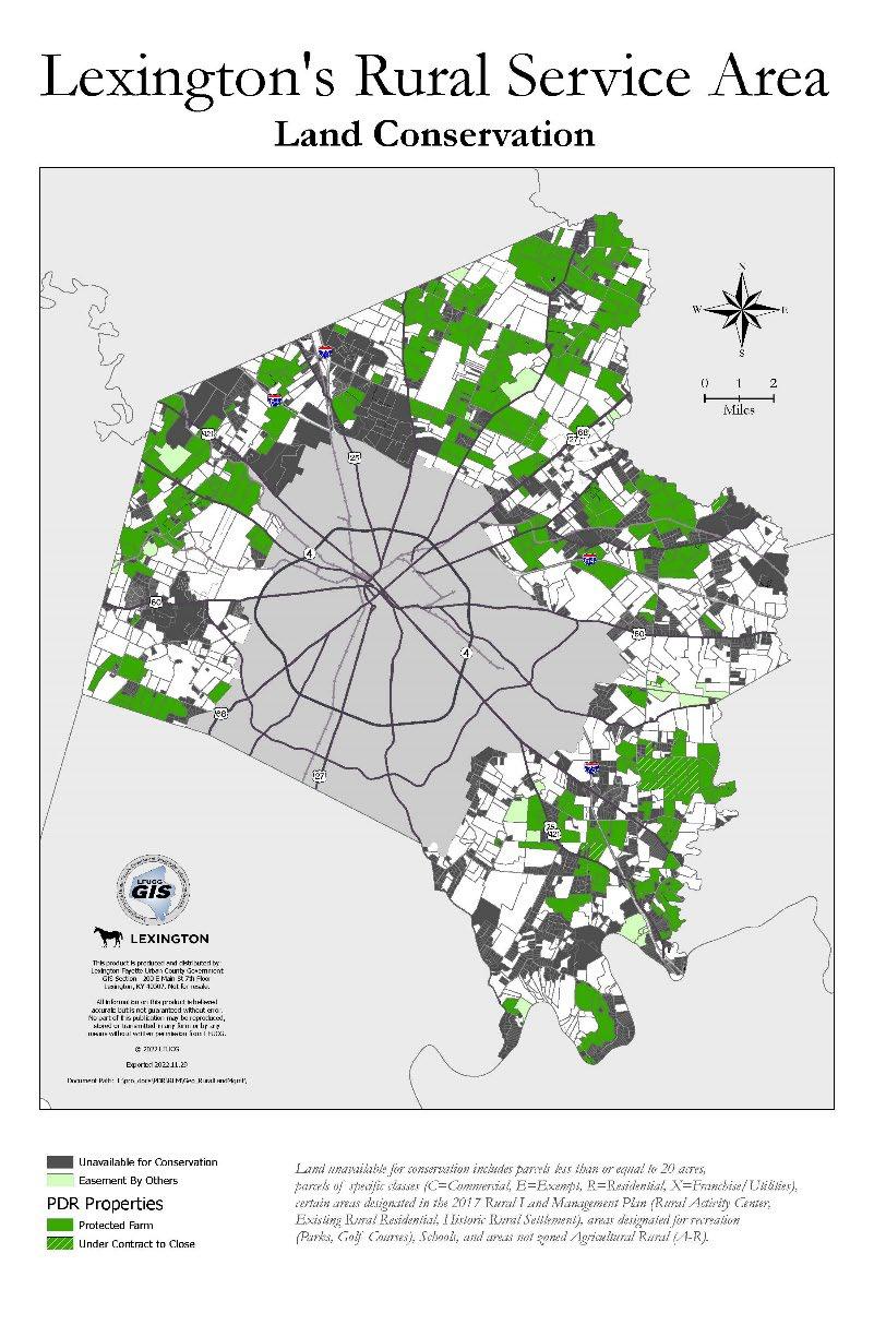
Land unavailable for conservation includes parcels less than or equal to 20 acres, parcels of specific classes (C=Commercial, E=Exempt, R=Residential, X=Franchise/Utilities), certain areas designated in the 2017 Rural Land Management Plan (Rural Activity Center, Existing Rural Residential, Historic Rural Settlement), areas designated for recreation (Parks, Golf Courses), Schools, and areas not zoned Agricultural Rural (A-R).

Q w Q I I I I I I ! ! I I ! ! I t I t This product is produced and distributed by: Lexington Fayette Urban County Government GIS Section 200 E Main St 7th Floor Lexington, KY 40507. Not for resale. All information on this product is believed accurate but is not guaranteed without error. No part of this publication may be reproduced, stored or transmitted in any form or by any means without written permission from LFUCG. © 2022 LFUCG Exported 2022.11.29 Document Path: T:\pro_docs\PDR\RLM\Geo_RuralLandMgmt\ ® 0 2 1 Miles Unavailable for Conservation Easement By Others PDR Properties Protected Farm Under Contract to Close


Rural Service Area Parcel Sizes Q Q I I I I I I ! ! I I ! ! I t I t ® 0 2 1 Miles Parcel Acreage 0 - 4.99 (1675 parcels) 5 - 9.99 (509 parcels) 10 - 19.99 (1040 parcels) 20 - 39.99 (276 parcels) 40 - 1065 (696 parcels) This product is produced and distributed by: Lexington Fayette Urban County Government GIS Section 200 E Main St 7th Floor Lexington, KY 40507. Not for resale. All information on this product is believed accurate but is not guaranteed without error. No part of this publication may be reproduced, stored or transmitted in any form or by any means without written permission from LFUCG. © 2022 LFUCG Exported 2022.11.29 Document Path: T:\pro_docs\PDR\RLM\Geo_RuralLandMgmt\
Lexington's
PURCHASE OF DEVELOPMENT RIGHTS (PDR) OVERVIEW

Urban Growth Management Master Plan Advisory Committee
August 15th, 2023
PDR Program Background
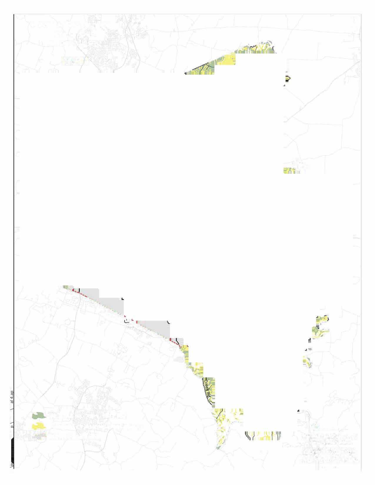
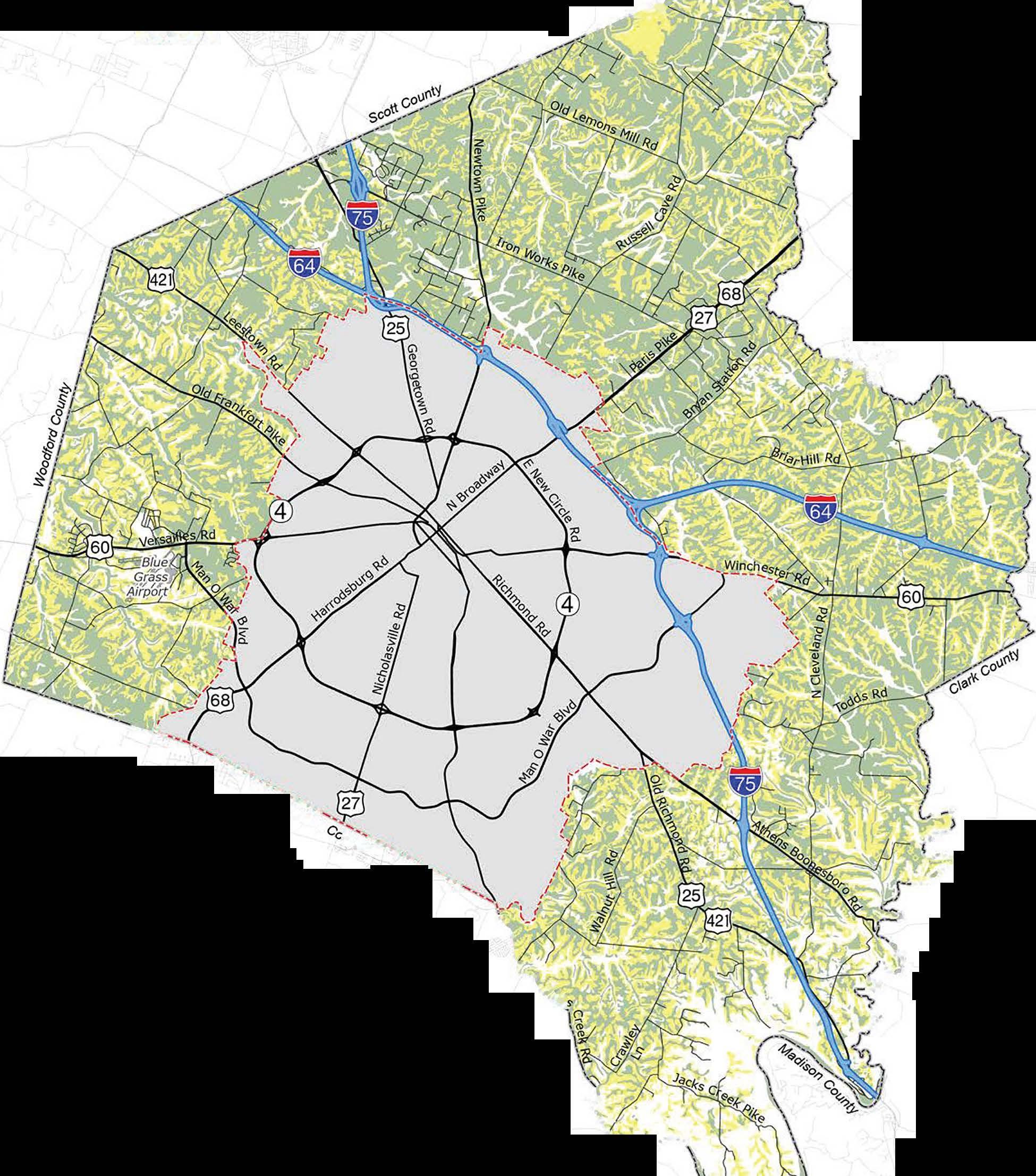
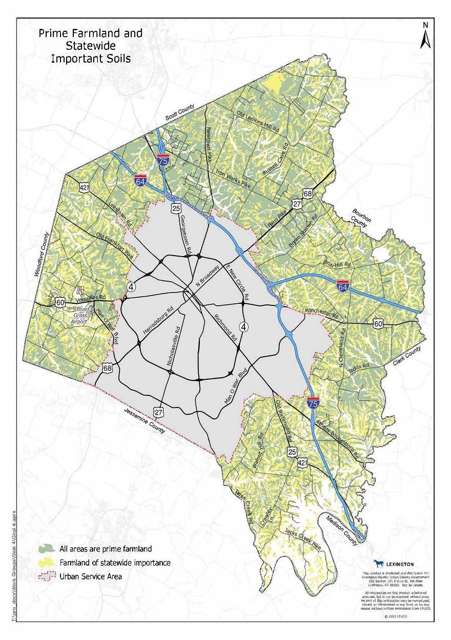
The Rural Service Area (RSA) of Fayette County is comprised of some of the highest quality soils in the nation. The prime farmland soils are illustrated in green in the map to the right, and the statewide important soils are in yellow.
Recognizing the importance of protecting these special soils and our working farms, the PDR Program was created in the year 2000.
The Program was created in conjunction with the Comprehensive Plan Update and the Rural Land Management Plan, and included changing the minimum lot size in the RSA from 10 to 40 acres.

The ordinance-stated goal is to purchase easements on 50,000 of the approximately 128,000 acres in the RSA.
PDR Report 2
Environmental Priorities
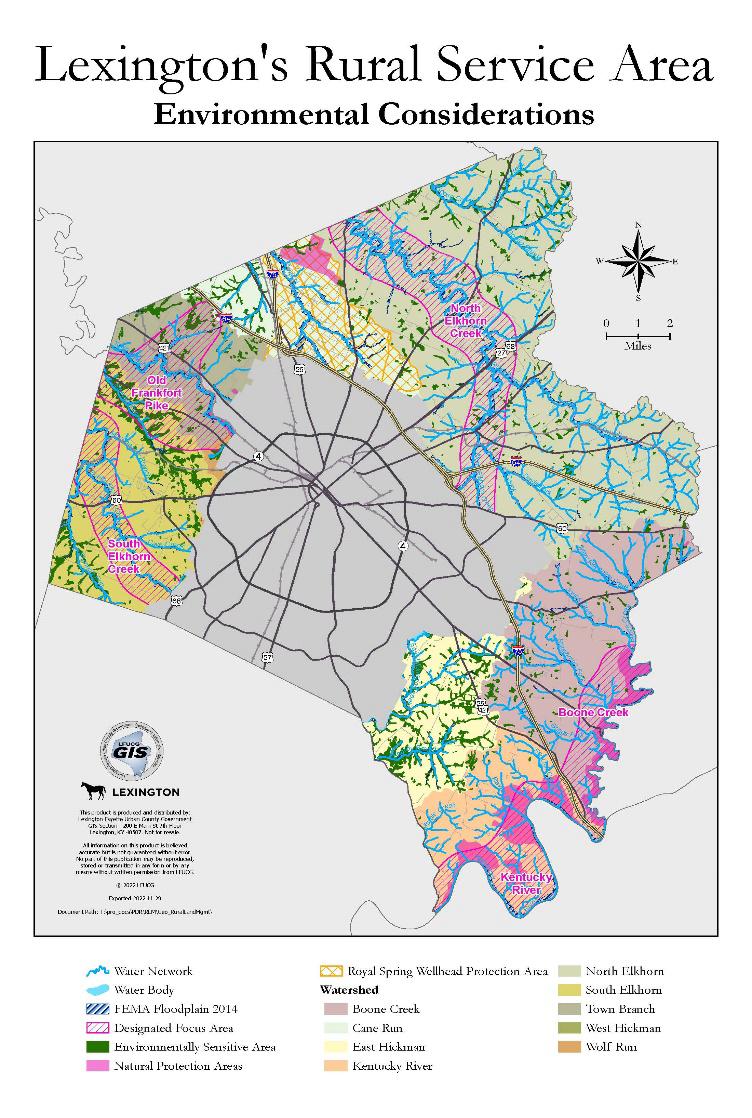
The Rural Land Management Plan (RLMP) recognizes 5 distinct Focus Areas and states they are especially important to conserve.
They are based on watersheds as indicated on this map and are the South Elkhorn, Old Frankfort Pike, North Elkhorn Creek, Boone Creek and Kentucky River Focus Areas.
PDR applicants receive a high number of ranking points for being in a Focus Area or the Royal Springs Aquifer Wellhead Protection Area. Being in these areas also negates any negative points awarded for being near the Urban Service Boundary or in a Sewerability Area.
PDR applicants also receive points for protecting other environmental elements as shown on the next slide.

PDR Report 3
Parcel Ranking Process
Any parcel in the A-R Zone that is at least 20 acres qualifies for easement purchase
Parcels are ranked using a Land Evaluation & Site Assessment (LESA) provided in Section 26-10 of the Code of Ordinances that includes:

Ag Supportive Scoring: Size of parcel, Soil Quality, Elimination of Undeveloped Nonconforming Tracts, Proximity to other PDR farms which builds critical mass, Batch Application, Farming Activities & Production, & Agricultural Infrastructure Improvements
Environmental Protection Scoring: Environmentally Sensitive Areas, Designated Rural Greenways, Designated Focus Areas, Natural Protection Areas & Wildlife Habitats, Links to parks, nature preserves, nature sanctuaries, etc., & Designated scenic viewsheds and other scenic resources such as tree canopies
Historic Protection Scoring: Historic and Cultural Resources including those designated for the National Historic Register, Designated federal, state, and local scenic byways and historic turnpikes, Stone fences, & Length of Public Road Frontage
Negative Scoring: Negative points are awarded to parcels in Sewerability Categories 1-4 and those within 1 mile of the Urban Services Area, unless they are in a designated Focus Area or Wellhead Protection Area, or a Community Icon.
PDR Report 4
Conserved Farms and Acreage
PDR is nearly 2/3 of the way to the 50,000 acre goal.
There are nearly 31,100 acres permanently conserved and nearly 2,100 acres under contract.
There are an additional 12 applications in the queue and the annual PDR application cycle will take place this fall.

It is a goal of both the PDR Program and the federal matching program to create clusters of contiguous conserved agricultural land, and you will see that on this map. Applicants receive points for being adjacent to a PDR or Bluegrass Land Conservancy easement and for applying with a neighboring farm. The Bluegrass Land Conservancy holds 18 easements in Fayette County totaling 2,300 acres.
The PDR Program has also avoided the “emerald choker” by awarding negative points to parcels adjacent to the Urban Service Boundary and those in a Sewerability Area, unless they are in a Focus Area or the Wellhead Protection Area.
PDR Report 5
Importance of Conserving 50,000 Acres of Working Farmland

The USDA Natural Resources Conservation Service with whom we partner states it well by saying “Agricultural Land Easements protect the long-term viability of the nation’s food supply by preventing conversion of productive working lands to non-agricultural uses. Land protected by agricultural land easements provides additional public benefits, including environmental quality, historic preservation, wildlife habitat and protection of open space.”
Though it would seem there is much land to conserve in Fayette County with nearly 128,000 acres in the Rural Service Area, mapping provided by our GIS staff shows how much land is excluded from potential conservation due to parcel size, existing commercial usage, residential use and developments, government owned properties, etc.
PDR Report 6
Importance of Conserving 50,000 Acres of Working Farmland continued

Additionally, further GIS mapping shows that 3,224 of the parcels in the Rural Area (76%) are less than 20 acres and therefore do not qualify for PDR easement purchase.
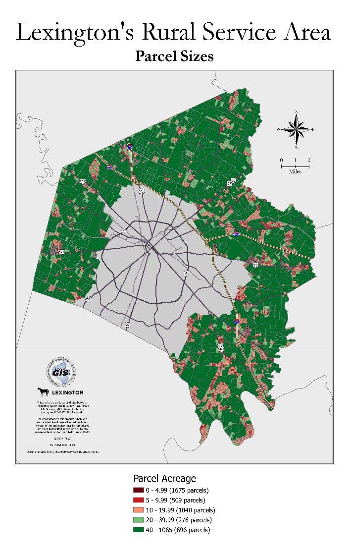
It is therefore vital that we protect the areas buffering PDR farms so that they may someday be protected and continue the pattern of contiguous conserved working farmland, and so that we honor the conservation commitment of PDR’s 285 farms.
It also makes us good stewards of the local, state and federal investment in these easements by ensuring farmers can continue farming, and good stewards of our environment by protecting our greenspace, streams, environmentally sensitive areas, and wildlife habits.
PDR Report 7
Helpful Notes about the Agricultural Land Easement (ALE) Language and Conclusion
Both the PDR and Bluegrass Land Conservancy easements are perpetual and transfer with the land.
Over half of the PDR easements have been purchased with federal matching dollars from the USDA Natural Resources Conservation Service.
The federal easement template we use includes the following language: Prohibited Uses:
(n) granting of easements or rights-of-way for power lines, gas lines, sewer lines, telecommunication towers, and wind farms.

It also states, “Due to the Federal Interest in this ALE, the United States must review and approve any proposed condemnation action that may affect the United States’ interest in the Protected Property.”
In closing, thank you for inviting us today. We greatly appreciate the opportunity to speak with you all and will be happy to answer any questions throughout this process.
PDR Report 8

Information
Overman
of Development Rights Director eoverman@lexingtonky.gov PDR Report 9
Contact
Beth
Purchase


