
PORTFOLIO


Lintang Ayasha | Selected Works
Redesign of Kampung Code Romo Mangun with Disaster Risk Management Principal, Final Project
Revitalization of Hotel Toegoe Yogyakarta Urban Heritage, 6th Architecture Design Studio
Onthouden, To Remember
Revitalization of Bioskop Dian, Competition Entry
Women and Children Urban Leisure in Kramat Pela, Kebayoran Baru, 1st Urban Design Studio
Kapin Creative Compact Neighbourhood in Jatibening Baru, Bekasi, 2nd Urban Design Studio
Festival City of Surakarta
Celebrating Liminality in Urban Transformation, Thesis Project

Preface
Graduated with a Bachelor of Architecture and a Master of Architecture focusing on Urban Design. I have been working as an architectural designer and drafter for hospitality and commercial projects and have advanced experience in research projects inside and outside agencies.
I’ve gained plenty of experience in research regarding kampung kota and have always been intrigued by social equality in urban settings. Equality, to me, means affording equal consideration to every aspect influencing urban life, even those that are often overlooked or marginalized.
Basic Info
Nathasya Lintang Ayasha Kirti, M.Ars nathasyalintang@gmail.com
+62 857 8655 0672
Sleman, Daerah Istimewa Yogyakarta
Education |
Sebelas Maret University, Surakarta 2017-2021
Graduated with GPA 3.75/4.00
Universitas Indonesia, Depok 2022-2024
Graduated with GPA 3.77/4.00
Working Experience
2024 | Jan - July
Assistant Lecturer on Pengantar Konteks Perkotaan, Dept. Architecture, Universitas Indonesia
2022 - 2023 | June - Jan
Architectural Drafter at CV. Sri Gading Contractor
2022 | Feb - June
Creative Design and Illustrator Internship at The Rare Plants
2021 | Oct
Assistant Design Mentor on Gojek x UNS “Inkubasi Bisnis”
2020 | Sept - Nov
Junior Architect Internship at Collabo Design Studio (CDS)
Academic Experience
2023 | Sept - current
Research member of RISPRO Research Collaboration between UI, LPDP, and Perumnas on “Mini Maisonette”
2022 | June
Research Assistant in UNCOVER to DISCOVER: The Audibility of Kampung Kemlayan
2021 | July - Aug
Parametric Bamboo Design for Post Disaster, International Virtual Courses, Architecture Dept. ITB
2021 | May - June
Head Researcher of Field Research in Kampung Code Romo Mangun Yogyakarta
2020 | June - Nov
Staff of Exhibition Planning, Archevent 2020 “Metamorfosis sebuah Ruang”, Architecture UNS
2020 | Jan
Volunteer of Exhibition Commitee on Earth Manual Project Exhibition, Jogja Gallery
2019 | Aug - Dec
Research Assistant of Urban Rural Design and Conservation (URDC Labo), Architecture UNS
2018 - 2019 | Nov - Oct
Head of Public Relations, HMA Vastu Vidya Architecture UNS
Awards
Presenter Paper
On International Conference of Business, Accounting, Supply Chain, and Logistic, FEB UNS (2019)
Presenter
On Regional Urban Social Forum “Another City is Possible” Surakarta (2019)
Honorable Mentions
On 120hours Mini Design Competition “Distancing Bench” (2019)
1st Place
On PARADESC 2020 Student Design Competition, Universitas Parahyangan “Adaptive Reuse” (2020)
Publications
Communal Housing Resilience in Kampung Code Riverbank Yogyakarta
Published on Arsitektura: Jurnal Ilmiah Arsitektur dan Lingkungan Binaan. doi:/10.20961/arst.v22i1.78311
Software Skills
Sketch Up AutoCAD 2D ArchiCAD
Enscape
Twinmotion Lumion
Adobe Illustrator
Adobe Indesign
Adobe Photoshop Advanced Advanced Beginner Advanced Intermediate Intermediate Advanced Advanced Advanced
Languange Skills
Indonesian - 578 (UKBI)
English - 568 (TOEFL)
Deutsch - A2 (cefr)
Redesign of Kampung Code
Romo Mangun
Typology: Masterplanning, Disaster Risk, Heritage, Urban settlements
Location: Jl. Jend. Sudirman No.44, Gowongan, Kec. Jetis, Yogyakarta
Supervisor: Dr. Eng. Kusumaningdyah N. H., S.T., M.T.
Ir. Maya Andria N., M.Eng.
“Rethinking the future of Kampung Code”
Kampung Code Romo Mangun is a settlement that located on the banks of Kali Code, Yogyakarta. Currently, Kampung Code Gondolayu is experiencing another crisis in settlements related to physical, ecological, and cultural conditions. Since the eruption of Merapi in 2010, the physical condition of the housing has continued to erode to the point of silting. At the same time, explosive population growth accompanied by the construction of permanent buildings poses a threat to future flooding. Although known as the re-settlement program by Y.B. Mangunwijaya in the past, until now, many of Romo Mangun’s works have been shifted due to the spatial needs of the population growth. Kampung Code Romo Mangun is well known for its successful re-settlement program. Various aspects of the settlements that have been built by the community and Romo Mangun in the past have changed the lives of the residents everyday living, in the meantime the changes also happen until today. If the values of living in Kampung Code continue to shift and affect local physical, spatial and social conditions, will Kampung Code survive in the future?
MACRO ISSUE MICRO ISSUE

water management cycle integration as flood mitigation system

ease of evacuation and secured settlements as secondary mitigation system

spatial quality improvement through circulation and spatial planning


Location Context

water management cycle integration in housing scale for flood mitigation conservation of heritage buildings and strengthening visual image


reviving Romo Mangun’s living paradigm: co-housing compact living

Kampung Code Romo Mangun is located under the Gondolayu bridge, Jl. Jend. Sudirman, Yogyakarta City. Total land area approximately 7,441 m2 with a total population of 230 people (68 families). Residents on average make a living as market workers, scavengers, casual laborers, or parking man. JUMLAH KK: 68
JIWA: 230
wisata
kegiatan ibadah
kegiatan riset
kegiatan sosial
User classification divided based on activities and number of family members per household. Meanwhile, visiting activities are secondary supporting activities beside the main activity: settlements activities.
community oriented humanscaled river oriented connected with nature
existing living life value of kampung code romo mangun

Macro Design Concept
The design concept of Kampung Code is to restore the vitality of the area: spatial, heritage, and ecological. This design concept is based on three main keywords, security, inclusivity, and flexibility.
Security, creating a safe and responsive space for river floods. Safe space is the main requirement for settlements.
Inclusivity, connecting space with users, accommodates various elements of the area: settlements, heritage, urban green spaces. Areas that are connected to their users have a higher chance of survival.
Flexibity, easy access in the area, freer circulation, and room to grow.


Gapura:


Water Management Integration
Kali Code has floods potential due to overflowing river water during the rainy season and cold lawa flows from the eruption of Merapi Volcano. Based on research (Astuti, 2014) Kampung Code will experience flooding as high as 50-80 cm at 25 year and 50 year return periods. Living on the banks of Kali Code with floods threat has become everyday life of the residents, so the design of the new Kampung Code must pay attention to the ecological conditions od the Code River and integrate living lide with the river water cycle.
The mitigation design concept in Kampung Code categorized into primary mitigation and secondary mitigation. Primary mitigation is an intervention carried out on a large design scale, including the design of constructed wetlands, embankments, and buffer zones. Secondary mitigation is small-scale intervention, such as evacuation routes, assembly points, and easy access to outside the area.


MACRO
Region Section


Building type in the settlements categorized based on its activities: public buildings, housing, ans public facilities. Existing housing designed by Romo Mangun has had the principle of compact living which is manifested in a human-scaled units that has small modular.
In addition, Romo Mangun’s dwellings also uses semi-permanent structure. This structure was chosen because the riverbanks cannot bear the heavy load of hard materials. Using natural and local materials, Romo Mangun’s dwellings dominated by the use of bamboo and wood. During the construction process, Romo Mangun made use of the surrounding materials that could be used.
Micro Design Concept
BUILDING COVER
WOVEN BAMBOO PANEL CLEAR POLICARBONAT PINK WALL PAINT FINISHING
BUILDING STRUCTURE

ONDULINE ROOF
BAMBOO ROOF FRAME
CONCRETE COLUMN BAMBOO REINFORCE.
GRC BALCONY BAMBOO FENCE WOOD FRAME
BAMBOO STAIRS WOOD SLAB


The Goals
The aim of Kampung Code Romo Mangun’s re-settlement is to restore the vitality of the area so that it can continue to survive in the midst of the vulnerabilities experienced: spatial, ecological, and cultural.
The re-arrangement of Romo Mangun’s Code Village combines the concept of community living in an area that is ecologically river oriented. All activities and arrangement of buildings and social spaces are reflected back to Kali Code. Creating linkages between users, spatial settlements, and Kali Code is the main key to the sustainability of Kampung Code Romo Mangun’s settlements.
Outer space, inner space, housing, and public space program as a whole, apply the principles of Romo Mangun adapted design. Although it does not guarantee 100% safety of the dwellings, the illustrated design is expected to be able to restore the paradigm of living in Mangunwijaya and affordable maintenance, improve quality, increase security, and maintain existing heritage values.

Revitalization of Hotel Toegoe Yogyakarta
Typology: Masterplanning, Heritage, Public Space, Tourism, Park
Location: Jl. P. Mangkubumi No. 5, Gedong Tengen, DIY
Supervisor: Ir. Widi Suroto, M.T.
“Rebranding abandoned heritage buildings”
The historical and cultural values are the foundation of tourism in Yogyakarta. In that case, many cultural heritage buildings in Yogyakarta which are then processed into cultural tourism objects. The cultural heritage which still spreads throughout the city became potential project for tourism development in Yogyakarta.
Hotel Toegoe Yogyakarta, which is located at east of Yogyakarta Tugu Station, is a cultural heritage building stipulated in the Regulation of the Minister of Culture and Tourism, Republic of Indonesia No. PM.25/PW.007/MKP/2007. Hotel Toegoe is a building that has been witnessing the history of Yogyakarta since before independence day. However, until now, Hotel Toegoe has been neglected and has become damaged because it does not have a function that can accommodate activities around it. In fact, Hotel Toegoe building has great potential in tourism development because of its strategic location and is on the imaginary axis of the Yogyakarta.


Macro Concept
According to the potential analysis of Contextual Architecture approach, to create a new image of Hotel Toegoe, several main functions need to be accommodated in Hotel Toegoe, which are:
• Tourism Information Center, tourist information center in the city for tourists who visit
• Local Community Space, space for local community in Yogyakarta for networking and branding
• Cultural Stage, a space to appreciate Yogyakarta culture and local artists
• Gastronomy Night Park, a night culinary park for culinary specialties of Yogyakarta and SMEs in Yogyakarta
• Transit Hub and Pick Up Point, tourist transit room for tourists and public transport pick-up point
Spatial Programming


There are two entrance from one way street Jl. Margoutomo: vehicle entrance and pedestrian entrance. Pedestrian entrance are across to Yogyakarta Train Station entrance. Meanwhile the exit divided into two: main exit on Jl. Margoutomo and side exit on Jl. Kleringan.
As a public space located in the heart of the city of Yogyakarta, the area also included with motorcycle, car, bus parking lot for visitors. There are also bike rental and public transport pick up point for visitors who do not use personal transportation.
east: Kp. Jogoyudan north: Jl. Malioboro west: Tugu Train Station south: Grand Zuri Hotel
Masterplan Design Concept
The concept of Contextual Architecture is applied to the spatial arrangement in accommodating the potential of the surrounding environment. The location of Toegoe Hotel is close to Tugu Yogyakarta Station, Malioboro, Yogyakarta Monument, and the center of the city so that the area arrangement is used to accommodate tourism, transit, culinary, networking and community activities, and history.


Community Center
Community Center is a forum for local communities in Yogyakarta, both local businesses, or social activities that are starting up adn developing.
This building accommodates; the Jogja Mural community, the Jogja Theater community, the Traditional Art community, the reading community, handicrafts, to an environmentally friendly community whose profiles and activities are interesting to show off to tourists who are present at the Toegoe Hotel. Community Center is more flexible with its functions, dynamically following user (communities) activities.

Tourism Info Center
Tourism Information Center is the main function of the building which consists of; Information Center, Travel Consultant, Locker Room, Maintenance Center Office, and Virtual Dioramas.
This building has a purpose to accommodate supporting activities for tourism activities in the city of Yogyakarta, so that tourists can find information for their tour here before continuing their trip.


Plaza Budaya and Gastronomy Park
Gastronomy Park is a culinary park for street vendors who usually placed around Hotel Toegoe and along Jalan Margoutomo. Taking advantage of the view towards Malioboro and the city’s good ‘ambience’, the culinary concentration of Jogja at the Gastronomy Park provides an opportunity for street vendors to peddle their wares with equal rights.
Plaza Budaya is an amphitheater that can be used for public activities, both community and outside the community. The location of the amphitheater behind the main building is intended so that the back wall of the building can be used as creative media such as a projector. The form also supports staging activities.


Transit Hub and Pick Up Point
Transit Hub is a temporary stop for public transportation that can be an alternative tourist transportation. This Transit Hub aims for tourists to help finding a point for vehicle after arriving in Yogyakarta (Tugu Yogya Station).
Pick Up Point is a public transportation pick-up point in Jl. Margoutomo, which is the link between Tugu Yogyakarta and Malioboro and Yogyakarta City Center. It is a strategic place to continue the journey with a choice of available transportation modes, including bicycle rental, tricycles, horse carts, Transjogja Buses, and online motorcycle taxis.
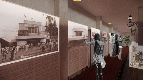
Onthouden
Redesign of Bioskop
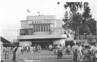
Dian Bandung
Typology: Heritage, Public Space, Adaptive Reuse, Community
Location: Jl. Dalem Kaum no.58, Alun-alun Kota Bandung, Bandung
Team: Fahran Nicole Russell, Muhammad Hasby M. A.
Supervisor: Dr. Yosafat Winarto, S.T., M.T.

“To
remember :
re visit, re watch, re imagined”
Bioskop Dian, also known as Radio City is one of the cultural heritage located in Bandung. Bioskop Dian, a public theater in its heyday, currently abandoned because of the unsuitable spatial program. Whereas, this building are the witness of History of Bandung City development and its society.
Movies, film, and theater are unseparable things. As an entertainment, movies considered as inclusive and affordable choice. In the other hand, the existence of modern theater makes Bioskop Dian’s significance in film industry become less seen. However, through decades, film industry are never out of time. Film industry growth especially in Bandung are one of the most noticable in Indonesia, proved by the annual ‘Festival Film Bandung’. Festival Film Bandung is the oldest film festival which organized by Forum Film Bandung that still happen currently. Local community’s attention towards the improvement of Indonesian film industry showed in many social event such as Yayasan Perfilman Sinematek and Indiecinema. To complete, local government also provide film themed public park called Taman Film in Jl. Pasupati.
ISSUE CONCEPT
An abandoned public theater, used to be theater for the Dutch noble Film as a sustainable and inclusive entertainment
Bandung and its anthusiasm towards film and the developments
Revitalizing Bioskop Dian’s heyday as theater
Learning through experienced -about film industry development
Empower communities, foundations, and society


Conservation Methods

currently, existing condition of object is surrounded by wild cadgers, reducing visual value of the heritage building.

main function of object is preserved into film development museum. Museum that gives historical theater experiences.

re-arrangement of existing cadgers : side alley used for food stall and cadgers, back area used for cart storage.

with adaptive reuse concept, the design oriented to preserve historical value and sustainability of the building.
Design Naration
Onthouden ‘To Remember’ is a museum-cinema; a museum to remember the history of film development and Bioskop Dian’s buidling history through cinema experience. Combining the concept of the historical journey of Bioskop Dian, film development, and the ‘juke box’ into the layout of space in the building. In addition to accomodating the activities of the museum-cinema, Onthouden also accommodates the activities of the Bandung film community such as Indiecinema. Misbar, is an event space that is designed alike ‘tantep screen’ that can be used eventually by the film community in Bandung. Meanwhile, the history of film development is presented through screening studios which are divided according to the time stamps of the film’s development; audio, silent films, black and white films, color films, to vcd/dvd players movie.
Interior design theme adapts the industrial rejuvination concept. By repairing parts of the building according to the original materials, and giving a fresh modern feel without changing too much of the ‘old’ atmosphere of the building. The aim is that the building will give two different impressions of space; ancient and modern.
The interior structure intervention also minimize permanent arrangement that may reduce the strength of its original materials structure. Using stilts deck concept on sirculation path prevent un-necessary demolition of original materials. For the screening studio and misbar, the structure adapting knock-down concept with steel, wood panel, pvc panel, and glasswool.


Spatial Program


Screening Studios
The screening studio is divided into 5 according to the time stamps of the film development history. Visitors can enjoy short film clips in each of the existing studios and get a unique and exclusive experience from each broadcast studio. Facilities in the studio also adjust to the year it takes place.

Misbar Gerimis Bubar
Misbar area or Gerimis Bubar, is an event space adapted from the traditional Indonesian urban habit concept known as layar tancep. Misbar can be used for community activities of film activists or community activities in general which can still be supported by the room.

Exhibition Area
The exhibition area is equipped with stilt pathways and displays in the form of historical photos and displays of antiques. The photos displayed are the history of the Dian Cinema building and the related stories. While goods display is destined for goods related to film, such as film rolls, cameras, plates, etc.

Urban Context
Bioskop Dian located in a strategic place in a heritage area located on Jl. Daem Kaum, Jl. Alun-Alun, Jl. Asia Africa. This area is very well known for its many cultural heritages and colonial buildings with ‘Art Deco’ style, which is one of the architectural identities of Bandung. Responding to its urban context in the heritage area, Onthouden (ex Bioskop Dian) wants keep contributing to the heritage area along the heritage axis. By adapting the function of the museum with a more modern management concept, in addition to extending sustainability of the building, its existence can educate visitors about the history of film and cinemas development, become places for entertainment, without casting out previous users (cadgers) and paying attention to their existing conditions.


Women and Children
Urban Leisure in Kramat Pela
Typology: Masterplanning, Urban Design Public Space, Public Park
Location: Kramat Pela, Kebayoran Baru
Supervisor: Prof. Ir. Evawani Ellisa, M.Eng. Ph.D
Dr. Ir. Achmad Hery Fuad, M.Eng.
Reviewer: Dr. Olga Nauli Komala
Aryo Kuncoro

NURTURE
Creating a safe and comfortable space for mother and child to grow and develop. Providing space for children in the city

“Dedicated urban leisure for woman and children”
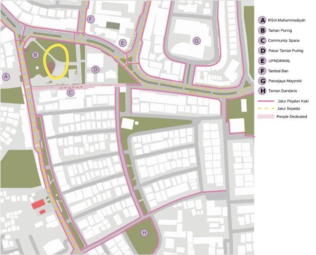
The Project was started from public park observation, specifically Taman Puring, located at Kramat Pela Kebayoran Baru. After observing the area around Taman Puring and the contribution of the public park for the area, we learned that the driving actors in Kramat Pela mostly are woman and children, influenced by the shopping activity from Pasar Mayestik and Pasar Taman Puring. The huge amount of women and children spending time around this area are the target of urban design.
Providing a comfortable and easily accessible space, especially for women and children as regional driving actors. The main vision in creating a more lively and productive Kramat Pela area is by closely integrating regional functions with urban leisure destinations.
The design strategy is divided into three main pillars; secure, nurture, and pleasure

PLEASURE
Integration of the area with daily family needs, social recreation, green space, family, shopping, etc. in the area
SECURE
Creating physically safe urban spaces, providing “eyes on the street” and public facilities that mothers and children need
Community multi-purpose women and community
Kiosks to the daily nearby settlement

land use from residential to mixed use = activating the facade to complete daily needs of the settlements Community Center, a multi-purpose space for children’s activities

Taman Puring the Oasis
Along with the working, shopping, retail, and commercial activity, Taman Puring works as an oasis between the crowd. People who spent their time in Taman Puring usually related close spatially with the Park, whether they work nearby, live nearby, or shops nearby.
To create more productive and prosper diverse function in the area, Taman Puring used as main connector of leisure activity at Pasar Mayestik, works at Jl. Kyai Maja, and daily activities for communities nearby.
People Density
Vehicle Density


Kampung kota


Informal activities are the primary pillar in revitalizing the area and bringing together the diversity of functions in the Kramat Pela. There are several different informal function: PKL Food around Taman Puring, Tambal Ban, Body Painting for Cars at Taman Gandaria, and so on. These activity keeps the area alive despite dominated by housing and offices that mostly have passive facade activity. 1 2 2 3 3 1

Along Jalan Kerinci, the west side is filled with tire repairmen. Quite well known in the South Jakarta area There is quite a large contribution of ‘people’ in areas other than Mayestik Market and Taman Puring Market


Open around the park, busy when there are quite a lot of park visitors. During the day it is sometimes visited by office people who works around. Customers utilized the seating in the Taman Puring as a place to eat
Informalities Study


There are some informal small business located around Gandaria Park and it doesn’t have a formal place, but along the road there are many people offering motorbike paint services. The road is used as a car park & place for painting
1
Providing a Community Center, a multi-purpose space that can be used by local residents and the public to carry out public activities, for example; Free immunization for toddlers and toddlers who can collaborate with RSIA Muhammadiyah
Playground connection by utilizing the green corridor, creating a safe path for children to use public spaces (Taman Puring to Taman Gandaria)
2 2 3 4 5 6
Rearrangement of the Mayestik area through the arrangement of PKL on Jl. Tebah so that it is neater and has a permeable facade. Utilizing the existence of Transjakarta Route 13 as a shopping alley, adjusting land use so that the Mayestik area can be used as retail shopping
Adjustment of land use at several points in the area, such as changing the designation of residential land to shophouses (Jl. Gandaria I and mixed use (Jl. Kyai Maja)

Creating pedestrian paths connected to destinations in the area, providing dedicated space for pedestrians (Jl. Gandaria III) and bicycle lanes
Integration of regional destinations, residential areas, with public transportation and alternative modes of transportation such as ojek online, bajaj, taxis etc.


Sky-busway giving the giant-tiny’ effect on pedestrian reducing the walking experience and comfort
an effort to provide active frontage --> UPNORMAL, engaging with pedestrian and street (public function, Hans Karssenberg)


Focusing on “eye on the street” by integrating facade activity with street furniture and park


Children

Public Plaza, injecting activity on ground floor level
Resting Pocket Plaza, strategic spot (visually) for resting, stop, and break for mother to take care of their children
Pedestrian Way Bike Path
JL. Bumi
Daycare, abandoned space on the 2nd & 3rd floor of Family Mart used for daycare to support mother activity around

Active Frontage, existing single use commercial converted into mixed use
Community Center, a multi-use space for community purposes
Vending Space, locker and nursery room for mother and children
Seating Area Taman Puring, mutual interface with existing PKL
Jalan Gandaria III
Taman Puring
Creative Compact
Kapin Neighbourhood
Typology: Masterplanning, Urban Design, Sustainability, Community
Location: Jl. Kapin Raya, Jatibening Baru, Bekasi Timur, Bekasi
Supervisor: Prof. Ir. Evawani Ellisa, M.Eng. Ph.D
Dr. Achmad Hery Fuad, M.Eng
Reviewer: Ardzuna Sinaga
“enhancing the value of neighbourhood a place where people can collaborated produced and perform in a closer distance”
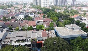
Jl. Kapin Raya, Jatibening Baru is experiencing quite rapid regional development due to the Cawang-Bekasi Line LRT development project which runs along Kalimalang. In this area there is one LRT station: Jatibening Baru, followed by the construction of the Gateway Park Apartments and in the process of building the PIM 5 Shopping Mall. The existence of this LRT station in the future will increase density and change the function of the area. Apart from the LRT development, this area is a densely settled area and has a community engaged in the arts.
In order to respond to the future development and possible growing density, without proper consideration of existing community, superblock development and Transit-Oriented may not become the effective solution. Creative Compact Neighbourhood is a vision of combining the opportunity from existing community and the on-going development of higher density planning.
Exsisting Issues
LRT Development marked the effort to revitalize Kalimalang area through public transport network (Jatibening Baru Station and Cikunir Station)
Apartment Gateway Park --> aiming for denser community, inflicted with gentrification around Jl. Kapin raya (more and more commercial anticipated)
Kalimalang --> strategic location connects between two municipality, Jakarta Timur and Bekasi Barat
Small local business, self-employment, local community business are found to grow around this area (ex: Gallert Kampoeng Baru, SMK Kawula Indonesia, UMKM, and flea-market)
Potential


CREATIVE COMMUNITY AND LOCAL BUSINESS GROWTH
EXISTING INTERMODALITY SYSTEM
VITAL ACESS: CENTER OF KALIMALANG
AIMING FOR HIGHER DENSITY
Problems


LACK OF IDENTITY AND SENSE OF PLACE POOR CONNECTION BETWEEN ACTIVITY NODES GROWING OF FUNCTION WITHOUT SPATIAL READJUSTMENT
CAR ORIENTED STREETS
Creative Compact Neighbourhood
A compact neighbourhood: where people can fulfill their needs within closer distance (Solarek, 2017)
A creative neighbourhood: where people works in art and creativity can socially work and collaborate with diverse perspective (Landry, 2012)
JALUR KRL CAWANG -BKS
MAIN ACTIVITY
LOCAL IMPORTANT
CONTRIBUTED TO IDENTITY
UNSECURE TENURE
STRONG BLOCKS
MAIN PATH
LEGENDA
1. LRT GATEWAY CITY APARTMENT
2. TAMAN KAPIN FOREST HUB
3. PASAR CERIA KAPIN
4. MASJID AL-INABAH
5. INDOMARET KAPIN
6. CAPITAL GAMING CENTER
7. GALLERY KAMPOENG BAROE
8. ART GALLERY IRAWAN KARSENO
9. MASJID JAMI NURUSSALAM
10. SMK TEKNOLOGI KAPIN
11. BINA SARANA INFORMATIKA
12. SMK KAWULA INDONESIA
13. EMBUN PAGI ISLAMIC SCHOOL

informality: festive market (fashion, foods, daily needs, dll) along Jl. Kapin Raya
Informality: PKL activities around the education areas
Irawan Karseno Art Gallery: painting studio
Education blocks: technology, art, and communication
PIM 5: future shopping centre
Pasar Ceria Kapin: traditional daily needs market
Gallery Kampoeng Baroe: guest house + gallery, and public space for residents and art and culture enthusiast
Public Transportation


There are no vehicle speed controls (pedestrians, signage, zebra crossings, etc.) while the space used for roads is very large, causing the area to become car-oriented.


LRT development opening access to the station at the threshold of the JKT-Cikampek toll privately
Some access are physically disconnected because they are directly adjacent to formal housing (gated communities)

PULO GADUNG-LAMPIRI
PONDOK KELAPA-BKN
CILILITAN-KLENDER
KAPIN-KAMPUNG MELAYU
CAWANG-BEKASI TIMUR
SUMMARECON BKS-BNN
BEKASI TIMUR-BNN
SUMMARECON BKS-TJ PRIOK
TITIK PERGANTIAN MODA
Land Use Accesibility Housing & Settlements


Commercial functions displace or combine residential land use and growth is still not well planned. The commercial type that is developing is dominated by small local businesses such as laundry, kiosks, restaurants, etc. and functions to support needs in settlements

Jalan Lingkungan perumahan menjadi jalan alternatif karena jalan utama over-capacity Rumah yang menempel dengan Jl. Kapin banyak dimanfaatkan untuk rumah toko
Indomaret meningkatkan aktivitas komersial dan menjadi katalis komersialisasi di JL. Kapin Raya

KAMPUNG KOTA

Main Program Strategies

Commercial Belt: enlivening the area through commercial functions that support the development of the Jatibening Baru LRT transit area
Cultural Belt: connecting activity nodes in the area via pedestrian activity and bicycle ways as well as green open space as a connector

Commercial Belt
Cultural Belt


Tol Jkt-Cikampek
Jalan Arteri
• Utara: Jl. Inspeksi Kalimalang
• Selatan: Jl. Jatibening Baru
Pedestrian Dedicated Strips
Jalan Kolektor: widening Jl. Kapin Raya (8 m)
Jalan Lokal:
• Jl. Rambutan
• Jl. Perundistrian
• Jl. Curug Raya
LRT Cawang-Bekasi Way
Specific Route: opening access to gated community connecting to kampung kota Halte bus/shuttle
Program Idea
Recalibrate the URBAN REALMS
Reclaiming spaces for people, public, green, and pedestrian
Embracing local growing community by giving exposure for interact and collaborate
Re-program neighbourhood function by combining more than single function to activated the district
Dedicated pedestrian paths connected to pedestrian plazas, public spaces and public transportation
Secondary pedestrian lane: pedestrian along with vehicle lane
Primary bicycle lane: a special bicycle lane separated from vehicles
Jak84 Route: Kampung Melayu-Jatibening Baru
Special Shuttle Line: Kapin Raya-LRT Apartment-
Gallery Kampoeng Baroe-Kalimalang Bus/shuttle stop
5 minute walking radius
Public Plaza
Mixed Zone: residential, retail and services, offices, high density
High Density Residential Zone
Medium Density Residential Zone
Low Density Residential Zone
Lifestyle District Services Retail Zone (Gym, Pharmacy, Minimarket, Fashion etc.)
Creative District Services Retail Zone (Coworking Space, Cafe, Rental Office, Communal Office, etc. with open access on the ground floor)
FnB District Service Retail Zone (Retail, Restaurant, Cafe, etc.)
Socio-Cultural Infrastructure Zone
Educational Infrastructure Zone
Recreation and Sports Infrastructure Zone
Activity Nodes
Recalibrate the URBAN FORMS
Mix land use (proximity over mobility)
Giving exposure to isolated building and function by land consolidation
Develop diverse choice of housing: high density (apartmen, tower, renthouse), gated community, kampung kota, and communal housing
Recalibrate the MOVEMENT CHOICE
Prioritazing people and proximity over vehicle and mobility
Encourage more sustainable movement: walking, cycling, and public transportation (Transjakarta, Jaklingko, Shuttle)


jalur kendaraan jalur sepeda setback komersial fungsi aktif bangunan: komersial, campuran

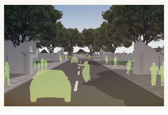
SECTION 4: CREATIVE DISTRICT - PARK


pedestrian strip
bike lane vehicle way bus stop gallery guesthouse kampoeng baroe
PERSPECTIVE
JL. RAMBUTAN - GALLERY KAMPOENG BAROE
PERSPECTIVE JL. RAMBUTAN - GALLERY KAMPOENG BAROE
bike path vehicle way pedestrian way pedestrian & folk art market
guesthouse kampoeng baroe

PERSPECTIVE JL. RAMBUTAN - CREATIVE DISTRICT

SECTION 5: JL. INSPEKSI KALIMALANG

PERSPECTIVE JL. INSPEKSI KALIMALANG
riverfront
riverfront
kalimalang
jalur sepeda pedestrian
Festival City Solo
Celebrating Liminality
Typology: Masterplanning, Urban Design, Cultural, Community
Location: City Center of Surakarta, Central Java
Supervisor: Dr. Achmad Hery Fuad, M.Eng
Prof. Ir. Evawani Ellisa, M.Eng. Ph.D
Reviewer: Prof. Antony Sihombing, M.P.D., Ph.D
Dr. Olga Nauli Komala
“celebrating festival liminality in urban space transformation”
This thesis aims to explain the phenomenon of festivals that occur in urban spaces and how the presence of festivals is related to the liminal space of the city. Festivals, as a public activity, have become a consideration in city planning, especially in cities oriented towards cultural tourism. Festival-oriented city planning is a new study in the field of urban design.
This project seeks to formulate design planning strategies by understanding festivals and realizing them through the liminality of spaces. This qualitative research focuses on understanding liminality through the mechanism of spatial transformation due to festival. The thesis will focus on the city of Surakarta as the research locus, considering the significant presence of festivals in the development of cultural tourism and as a sustainability strategy for the city. The result of this research is a design planning strategy for the city oriented towards festivals, taking into account the liminality of spaces in the city.
CELEBRATING LIMINALITY THROUGH FESTIVAL:
How liminality presents?
How liminality transform space into place on festival:

Brandberg
Liedgren
Aelbrecht
OLD CITY CENTER OF SOLO

It is the old city center area of Surakarta which vitality is decreasing significantly.
Based on the results of the study, the community and vitality of the area are important determinants in the success of the festival, such as in the case studies at the Gion Festival or La Rambla
The lack of human activity in this area threatens the vitality of the city center area, especially Vastenburg Fort -PGS-Alun-alun and Kraton. Moreover, if the Local Government wants to restore the vitality of the Kraton, then the surrounding area which include the supporting density also needs to be considered.
OLD CITY CENTER OF SOLO
Urban Context Analysis

PAGELARAN SASANA SUMEWA
In some case, this space used as the starting point or preparation space before the ceremony start.
Alun-alun historically used as a public plaza for people to gather and have social activity due to Sunan’s order
used to be commercial centers for fashion, it is now abandoned and have no significant activity There are no constant activity in Kraton Kasunanan Surakarta and its surroundings
pedestrian,transport,becak, andong
Although the morphology of Surakarta city no longer refers to the layout during the Kraton era, this axis is still remain as an important route in urban activities.
The city center of Solo is the Pemandengan Monument, right in front of Surakarta City Hall.
This area shows the characteristics of the mixed identities in Solo City: the Islamic Mataram Kingdom and the Dutch. This acculturation represent the identity of Solo’s morphology. Unfortunately, the vitality of the palace area continues to decrease.

transport: becak ‘ngetem’
way used for PKL activity
ALUN-ALUN UTARA
Balai Kota
Patung Slamet Riyadi
Benteng Vastenburg
TUGU PEMANDENGAN
Pagelaran Sasana Sumewa are special place to conduct cultural ceremony, festival, related to Kraton Kasunanan Surakarta.
Section C-C’

Design Strategies
Surakarta is a small city and does not have many natural attractions to offer. Therefore, city and cultural tourism are the main strengths of city tourism.
Festivals in Surakarta are also a promotional medium for tourist destinations in the city, providing exposure for city tourist destinations and increasing regional productivity during the festival.
Backgrounds
Festivals in Surakarta are greatly influenced by the acculturation that occurs. Festivals are no longer closely related to the culture of the Surakarta Kasunanan Palace, but are instead closely related to communities and societies with distinctive cultures that are acculturated and influenced by their regions.


Taman Sriwedari Area
Alun-alun Utara
Benteng Vastenburg
Redesign strip of Jl. Kebangkitan Nasional
Re-adjusting land use and zoning
Re-enhance junction identity
Guideline commercial facade
Pedestrian Public Plaza
Guideline facade for kampung alley
Shopping alley PGS
Galabo Solo Culinary


Festival Recomendation
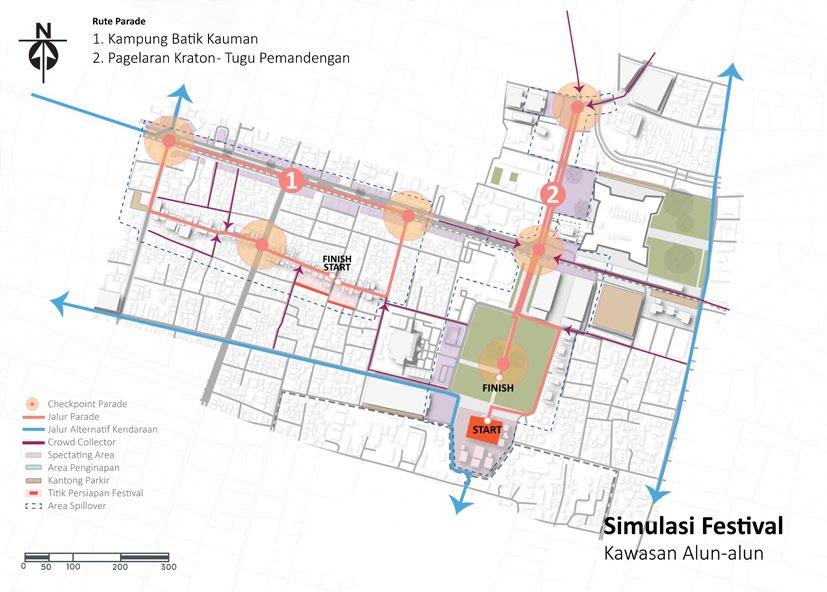
Taman Sriwedari Route Parade
• Solo Menari (Pre-Event)
• Wastra Nusantara Fashion
• Festival Reog
• Solo Batik Carnaval (Pre-Event)
Performance & Show
• Pentas Wayang Orang
• Sendratari Ramayana
• Hari Jadi Museum Radya Pustaka
Market & Fair
• Sriwedari Berkicau
• Pasar Seni dan Budaya (di bulan tertentu)
• Gebyar Bakdan
• Solo Batik Carnaval (Pre-Event)

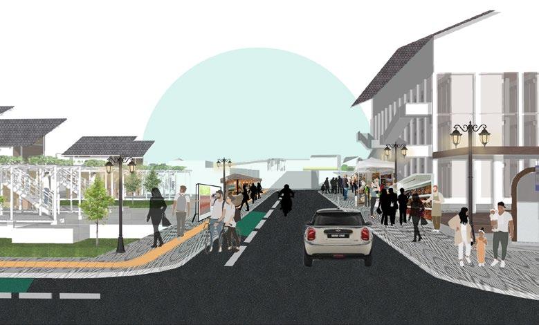
Jl. Kebangkitan Nasional
Daily Activity Condition
Jl. Kebangkitan Nasional Jl. Slamet Riyadi
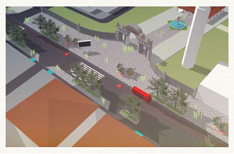
During Festival Simulation
Jl. Kebangkitan Nasional Jl. Slamet Riyadi 1 1 2 2


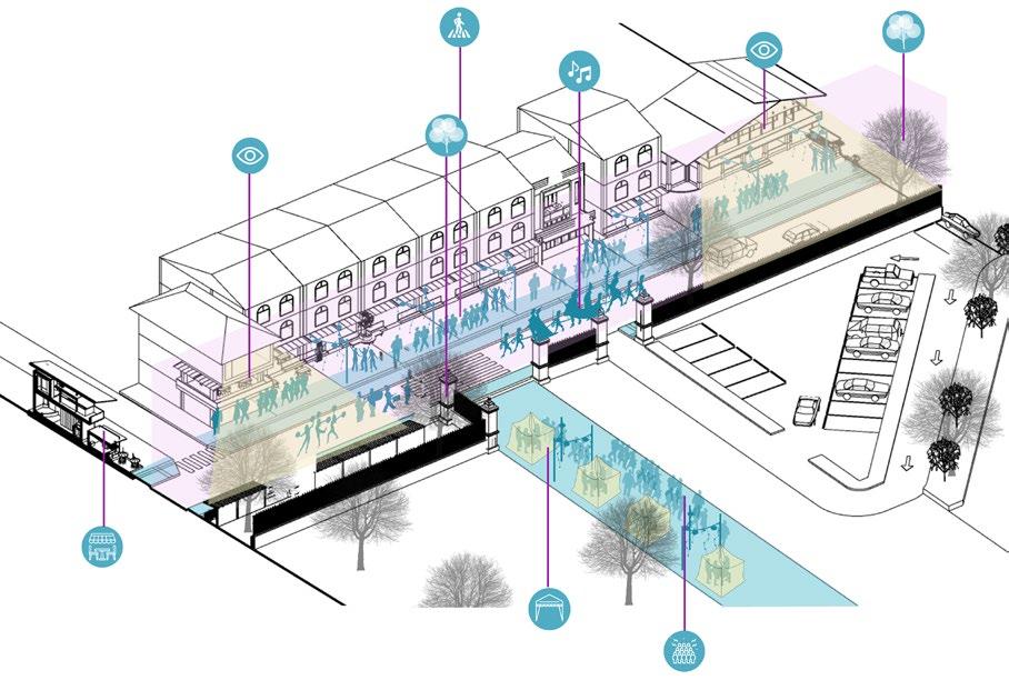
Balcony: Eye on the Street
Pedestrian Access


Festival Recomendation
Alun-Alun Utara Route
Parade
• Kauman Batik Art Festival
• Solo Menari (Kemlayan)
• Kirab Prajurit Kraton
• Kirab Malam 1 Suro
• Kirab Putra-Putri Solo
• Peringatan Pokoso
Performance & Show
• Solo International Performing Art (SIPA) Festival
• Konser Musik (Benteng Vastenburg)
• Pertunjukan Musik/Tari (Plaza Pasar Klewer)
Market/Fair
• Solo Great Sale
• Solo Food Festival
• Grebeg Maulud


Pringgitan Alun-alun - Pasar Klewer
Pedestrian Plaza
Pagelaran Sasana Sumewa
Alun-alun Utara
Pasar


Section E-E’
Section F-F’


Persimpangan Slamet Riyadi
Jl. Pakoeboewono
Persimpangan Slamet Riyadi Jl. Pakoeboewono
Daily Activity Condition


Spectating
During Festival Simulation
Jl. Slamet Riyadi - Jl. Jend. Sudirman
Jl. Slamet Riyadi - Jl. Jend. Sudirman Enhance Identity
Perkantoran
Perkantoran
Pedestrian Shopping Alley PGS
Galabo Food Culinary (Street Dining)
Mini Amphiteater
Landmark Kawasan


