FinalReport ShinnecockNation
IndigenousEnvironmentalPlanning
May10,2024
TeamMembers:AnushreeChaudhuri,MilanChuttani,YvetteKleinbock,SaynabMaalin,Keili Tucker,SanjanaPaul
ShinnecockNationCollaborators:PhillipBrown,ShavonneSmith
Introduction
ThisreportpresentsthecollaborativeworkbetweenourteamandtheShinnecockNationto supporttheTribe’sclimateactionplanningandlanduseinitiatives.ThroughtheEPA’sClimate PollutionReductionGrant(CPRG)program,weassistedtheNationindevelopingfoundational resources,suchastheGreenhouseGasEmissionsInventory,thePriorityClimateActionPlan, andinteractivecommunitystorytelling,landuse,andscenariovisioningmaps.Additionally,we facilitatedparticipatorymappingworkshopsanddevelopedacomprehensive,adaptablemapping toolkittosupporttheShinnecockNationintheirjourneytowardsustainability,sovereignty, culturalpreservation,andeffectivecollaborationwithpartnersandstakeholders.
Throughoutthisprocess,weemphasizedcommunityengagementandcapacitysharingtoelevate thevaluesandprioritiesoftheShinnecockNationinclimateactionandlanduseplanning.By listeningandlearning,wegainedvaluableinsightsintothecomplexitiesofnavigatingdiverse perspectiveswithinIndigenouscommunities.Ourgoalistoensurethatthiscollaborationleaves theShinnecockNationwithpracticaltoolstocontinuetheirvisioning,advocacy,andaction towardasustainablefuture.
ProblemStatement
IncollaborationwithShinnecockNation’sEnvironmentalandHousingdepartments,we identifiedtwoprimaryareasoffocusfortheproject:1)thesubmissionofaPriorityClimate ActionPlanandothergrantdeliverablesfortheEPA’sClimatePollutionReductionGrants program,and2)anincreaseindocumentationandparticipatorymappingworkshops/onlinetools tosupportalldepartmentsintheNationwithimplementationoftheir2021LandUsePlan.Based onoursitevisittakeaways,backgroundresearch,andconversationswithShinnecockleaders,our maingoalswereto:
1. AssistwiththeEPAClimatePollutionReductionGrantapplicationbyanApril1st deadline,includingsupportingtheseapplicationcomponents:acompletedraftofthe QualityAssuranceProjectPlan(QAPP),apreliminarygreenhousegas(GHG)emissions inventory,andacompletedraftofaPriorityClimateActionPlan(PCAP).
2. DocumentmethodologyandstepstakentocompletetheGHGemissionsinventoryand consolidatedatacollectedforfutureusebytheNationinacomprehensivedocumentation andresourcestoolkit.
3. Helpfacilitateparticipatorymappingworkshopstocreateaneditable,interactiveonline “CommunityStoryMap”thatdocumentspastmemoriesofthelandaswellasfuture visionsforwhatthelandcould be.Wesupplementthisprocesswithatoolkitfor residentsandTribalstaffwithinstructionsonhowtofacilitateparticipatorymemory mappingactivitiesanddigitizestoriesfromtheseconversations,andaddthemtothe collective“StoryMap.”
4. Createaninteractivelandusemapthatdocumentsandanalyzesecological,cultural, economic,andlanduseresources,opportunities,andrisks.
5. Developaseriesofinteractive,adaptablehousingsiteplanscenariosthatattemptto implementShinnecockvaluesfromparticipatorymappingworkshopsintolanduse planning.Wesupplementthesesiteplanswithrenderings,precedents,andaseriesof designcapacity-buildingmaterialssoTribeleaderscancontinuemodifyingplansas circumstancesevolve.
6. Handoffextensivedocumentationandatoolkitaroundconductingparticipatorymapping workshopsinthefuture,creatingsimilarscenarioplansusingmappingtools,and continuingtousetheFeltplatformfordocumentationandanalysis.
BackgroundandContextualInformation
BackgroundontheShinnecockNation
TheShinnecockIndianNationhasoccupiedtheeasternendofLongIslandforover13,000 years.TheyhavetheirowndistinctculturewithinthelargerAlgonquianlanguagegroup. Shinnecockmeans“peopleofthestonyshore,”reflectingtheirintimatetiestothecoastallands. AfterEuropeancolonization,theNationsufferedgreatlossesofland,population,andcultural identity.Today,around1,500enrolledmembers—manyofwhomliveontheterritory—continue toupholdShinnecocktraditions.TheNation’sterritoryspansabout1200acresofancestralland attheeasternendofLongIslandadjacenttoSouthampton,NewYork.About700residentslive onthe900-acreterritoryonthepeninsula,referredtoas“theneck,”andanadditional100acres oflandislocatednearHamptonBays,NY,andservesasaTribalgatheringplace.TheNation achievedfederalrecognitionin2010andexercisessovereigntyoveritsterritory.Governance involveselectedtribalTrusteesandtheGeneralCouncil,includingallvotingmembersofthe Nation.Keygoalsarereclaiminglanguageandculture,generatingeconomicopportunities,and adaptinginfrastructureandhousingforthefuture.
ContextoftheLandUsePlan
Therecentlanduseplan,developedbetween2018and2021undertheleadershipofthe ShinnecockEnvironmentDepartment(SED),wasinformedbyextensivecommunityinput.The Tribecommunallyownsthemainterritory Historically,residentialallotmentswereallocatedto members.Demandhasfaroutpacedsupplywithseverehousingshortages.Theplanaimsto balancedevelopmentwithpreservingnaturalandculturalresources.Prioritiesincludeexpanding housingstock,restoringnativeplants,improvingroadsandenergysystems,acquiringnewlands
forgrowth,documentingculturalsites,andpreparingforclimatechange.However, implementationoftheplanhasbeenslow,andgreatercoordinationanddocumentationare neededacrossdepartmentsonprogressandevolvingpriorities.
InitialSiteVisitTakeaways
Severalmembersofourteamattendedatwo-dayintroductorysitevisitinearlyFebruary2024, meetingwithNationleadersacrossdepartments.Wewereprivilegedtoalsoviewsome importantsitesaroundtheNationandhaveafocuseddiscussionwithourpartners,PhillipBrown andShavonneSmith.Keythemesweobservedincludedexpandinghousingandtransportation infrastructurewhilepreservingopenspaceandrestoringtheland;mitigatingclimateandcoastal threats;systematicallydocumentingculturalknowledgeandsites;andcreatingacentralizeddata ormappingplatformtocoordinatedepartmentalgoalsaroundlanduse.Theseinsightsshaped ourprioritiesduringthesemestertohelptheNationcollectandvisualizeimportantspatialand culturaldataontheirterritory Amoredetailedbreakdownofspecificthemes,challenges,and opportunitiesarediscussedbelow
MainThemes
● Culture
○ Description: Documentingelderknowledgeofculturalandenvironmental resources,includinghowperceptionsandstoriesfromthelandhavechangedover time.
○ Challenges: Oralhistoriesandtribalknowledgearenotsystematically documentednorproactivelyincorporatedintolanduseplanningandsitingefforts. Youthengagementislow.
○ Opportunities: Createarepositoryforelderinterviewsandculturalinfo.Involve youthindatacollection.Mapknownculturalsitesandpathways.
● Data/Planning
○ Description: Desireforcentralized,interactivemapsanddatasystemsto coordinateacrossdepartments
○ Challenges: Dataiscurrentlysiloedandinconsistent.Hardtocommunicate insights.
○ Opportunities: Co-designasharedmappingplatformforvariousdatalayers.Host aworkshopandcreateatoolkittoensurenewmemberscanuse,modify,and enhancethesemaps.Demonstratevalueandprovidetechnicaltraining opportunitiesfordepartments.
● Housing
○ Description: Yearsofsystemicdisinvestmentfromtown,state,andfederal partnershaveleftmanyhomesindisrepair,increasingtheneedfor
environmentallysustainablebuildingretrofitsthatalignwithTribevalues.Inan attempttopreserveculturalandecologicalresources,theTribehasputa longstandingmoratoriumongrantingnewallotments.Thereisthusacurrent shortageofhousingcapacitywhichmakesitchallengingforelders,veterans,and off-TerritoryTribememberstoreturnbackandfindstablehousingonthe Territory.
○ Challenges: Only5outof20-30elderscurrentlyhavededicatedhousing.There arenotenoughallotmentstomeetdemand.Existinghomesneedmajorrepairsor fullrebuilds.
○ Opportunities: Surveyexistinghousingstockandforecastfutureneeds.Visualize potentialnewhousingsiteslikeWestwoods.Streamlinetheallotmentandrepairs process.Considerdifferentpolicyoptionsforabandonedallotments.
● Transportation
○ Description: Thereisastrongdesiretoprotectandenhancetraditionalpathways andtrailsasnewpedestriantransportationcorridors.Thisisespeciallytruewithin theWestWoodsareawhichisahighlycontested,culturallysignificantarea,for futureplanning.
○ Challenges: Existingpathwayshavebecomeovergrownovertime.Needsafe pedestrianroutesacrosstheterritory.
○ Opportunities: Mapoldpathwaysandconceptualizehowtheycouldbecome trails/sidewalks.VisualizepotentialtransportationneedsifWestwoodsdevelops. Illustrateconnectionsbetweenkeypointsontheterritory.
● Environment
○ Description: Prioritiesaroundprotectinggroundwater,coastalresilience, renewableenergy,climateimpacts,andfloodingaredocumentedinthe2021 LandUseplan.
○ Challenges: Theterritoryisatriskforgroundwatercontamination.Coastal erosionandsealevelriseposethreatstohousing,cultural,andecological resourcesduetoclimatechange.Strongneedforenergyindependence,climate adaptationplanning,andresilienceasameansofpromotingTribalsovereignty.
○ Opportunities: Mapfloodvulnerabilityandidentifyregionsandhomesthatmay beatrisk.Inventorycoastalresourcesanddunes.Sitepotentialrenewableenergy projects.HelpwithgreenhousegasinventoryfortheCPRGgrant.
ClimatePollutionReductionGrant
Overview
TheShinnecockIndianNationisparticipatingintheU.S.EnvironmentalProtectionAgency (EPA)’sClimatePollutionReductionGrant(CPRG)Program.TheCPRGProgramusesfunding fromtheInflationReductionActtoprovidefinancialandtechnicalsupportfortribes,territories, states,andmunicipalitiestodevelopplansandimplementprojectstoreducegreenhousegas emissionsandbuildresilienceagainsttheimpactsofclimatechange.ThePlanningPhaseofthe grant,whichtheNationalreadyreceived,providesbetween$1-$10Minfunding.Bycompleting thedeliverables(suchasthePriorityClimateActionPlan),theNationbecomeseligiblefor ImplementationPhasefunding(upto$25M)toallowforimplementationofprioritiesidentified inthePlanningPhase.
TheCPRGProgramalignswellwiththeShinnecockNation'songoingeffortstoprotectthe environmentandprepareforachangingclimate.AsstatedintheirLandUsePlan,theNation desiresto“protecttheterritoryandthenaturalresourceswithinthemanmadeboundaries”as wellas“initiaterelationshipsandagreementstoaddresscommongoals”withsurrounding communities,recognizingthatairandwaterresourcesaresharedbeyondthereservation.
WiththeCPRGPlanningPhaseGrant,theShinnecockNationisrequiredtoproduce:
● Acomprehensivegreenhousegas(GHG)emissionsinventoryutilizingtheEPATribal GreenhouseGasInventoryTool(TGIT)
● Anassessmentofthelegal,technical,andeconomicfeasibilityofemissionsreduction pathways
● APriorityClimateActionPlan(PCAP)identifyingGHGreductionoptionsacross energy,transportation,buildings,waste,andlandusesectors
● AComprehensiveClimateActionPlan(CCAP),dueattheendofthegrantperiod,which furtherrefinestheGHGemissionsinventory,establishesasystemtomonitorprogresson emissionsreductiongoals,andfurtherquantifiesestimatesofpotentialemissions reductionsandassociatedhealthbenefitsandimprovementsinenvironmentaljusticefor eachstrategy
Developingthisdata-drivenfoundationpositionstheShinnecockNationtomakeclimate prioritiesactionableandequitable.Advancingcleanenergy,sustainablebuildingdesign, recyclingprograms,nativeplantingsandmorewillhelptheNationmitigatetheirclimateimpact whilecreatingjobsandimprovingqualityoflife.ThroughtheCPRGprogram,theShinnecock Nationcantakeanimportantstepforwardinmaintainingasustainableandculturallyvibrant community,guidedbytheirtraditionalvaluestoprotecttheair,water,andsoilforthenextseven generationswhilealsoaddressingclimaterisksusingfederalfunding.Withlong-termplanning andstrategicinvestments,theNationcanleadinthefightagainstclimatechangethrough incorporationofTraditionalEcologicalKnowledge.
QAPPandPCAPOverview
TheShinnecockNationwasawardedaClimatePollutionReductionGrant(CPRG)planning grantfromtheEPAin2023,althoughlatedistributionofthefundingdelayedtheNation’s efforts.OurteamassistedtheNationwiththreekeycomponentsofthegrantdeliverablesbyan April1stdeadline:theQualityAssuranceProjectPlan(QAPP),aninitialgreenhousegas(GHG) emissionsinventory,andthecompletePriorityClimateActionPlan(PCAP).FortheQAPP,we helpedformalizeprotocolsforcollectingandmanagingdatathatfollowsEPAstandardsand developedaworkplanandorganizationalstructureforimplementingthePCAP.Thiscompleted, 55-pagedocumentwassubmittedtotheEPAonMarch14thandacceptedwithminorcomments onorbeforeMarch28th.
FortheGHGemissionsinventory,weworkedwiththeNationtoestimateemissionsfromkey sectorslikevehicles/transportation,buildingheating,electricity,water,wastewater,solidwaste, forestry,andagriculture/landmanagement.ThroughoutthemonthsofFebruaryandMarch,we coordinatedacrossdepartmentstouseexistingdata,requestpublicrecordsthroughFOIL proceduresfromPSEGLongIsland,NationalGrid,andtheSuffolkCountyWaterAuthority,and supplementedavailabledatawithestimateswhereexactnumberswerenotavailable.Thishelped establishabaselineunderstandingofcurrentemissionssourcestoinformreductiontargetsand prioritiesinthePCAPandeventuallytheCCAP Anoverviewofthegeneralprocessrequiredto conductaGHGEmissionsinventoryisincludedbelow
Figure 1 The EPA’s suggested process for conducting a GHG Emissions Inventory for major companies, municipalities, and Tribal governments (Source: EPA)
InconsultationwithShavonne,Phil,andotherShinnecockleaders,wecompletedotherPCAP componentsincludingintroductorysections,asummaryoftheGHGemissionsinventory findings,projectedemissionstrends,emissionsreductiongoals,benefitsanalysis,andreferences. WesubmittedourcompleteddraftofthePCAPtotheShinnecockEnvironmentalDepartmenton March28th,anditwassubmittedtotheEPAbytheApril1stdeadline.SubmissionoftheQAPP andPCAPwasadeliverableoftheexistingfundingfromtheCPRGPlanningphase.IfthePCAP andothergrantcomponents(suchasaworkplan,budget,andcoverpageduebyMay1st)are acceptedandevaluatedcompetitively,theNationwillalsobecomeeligibleforsignificantlymore implementationfunding(between$1–25million).Thus,oursupportwiththeQAPP,PCAP,and GHGinventorydeliverableshelpedexpandopportunitiesfortheNationtoaccessexpanded CPRGfundsforimplementingpriorityclimateactions.
ReviewofGHGEmissionsSectors
IncompletingaGHGemissionsinventoryandPCAPfortheNation,ourteamreviewedand researchedinformationonemissionscategoriesanddatasourcestoacquirebaselineestimatesof annualemissions.Atablesummarizingsomeofourfindingsandanoutlineofthedatasources weconsultedisincludedbelow
SectorsIncluded inInventory RationaleforIncludinginGHGInventory
Mobilecombustion Transportationactivitieswerethelargestsource(29percent)oftotalUS greenhousegasemissionsin2021.From1990to2021,transportationCO2 emissionsfromfossilfuelcombustionincreasedby19percent.Transportation activitiesoccuronalltriballands MostresidentsandoperationsintheTribe utilizemobilecombustionfortransportationthroughtheuseofprivateor Tribe-ownedvehicles
Electricity consumption Theelectricpowersectoraccountedfor25percentoftotalUS greenhousegas emissionsin2021.ShinnecockNationisservicedbytheLongIslandPower AuthorityandthePublicServiceEnterpriseGroup(PSEG)LongIsland,with residentialandcommercialenergyservicedbytheutilityforwhichconsumption datawillbecollectedthroughapublicrecordsrequesttoPSEGLongIsland Severalsmall-scalesolarphotovoltaicsystemsareoperationalorindevelopment andhavealsobeenincluded.TheNationdoesnotownoroperateanyutility-scale powergenerationfacilities
Urbanforestry Thissectorincludesfluxesofcarbonfromactivitiessuchasconvertingforeststo agriculturaluseandpracticesthatremoveCO2 fromtheatmosphereandstoreitin long-termcarbonsinkslikeforests In2021,thenetCO2 removedfromthe atmospherebynaturalandworkinglandswas12%oftotalU.S.greenhousegas emissions Between1990and2021,totalcarbonsequestrationinthissector decreasedby14%,primarilyduetoadecreaseintherateofnetcarbon accumulationinforests,aswellasanincreaseinCO2 emissionsfromurbanization ShinnecockNationhostsareasofforestandvegetationthathavebeenincludedin carbonsequestrationestimates.
SectorsIncluded inInventory
RationaleforIncludinginGHGInventory
Agriculture&land management Agricultureaccountedforabout10percentofU.S.greenhousegasemissionsin 2021,andagriculturalsoilmanagementwasthelargestsourceofN2Oemissions. EntericfermentationwasthelargestsourceofCH4 emissions Thereisno commercialagricultureonTriballandsatthemoment,althoughthereareseveral residentialandrecreationalareasofvegetationforwhichfertilizerconsumption datahavebeenestimated.
Stationary combustion (includingfor commercialand residentialheating)
Solidwasteand wastegeneration (optional)
In2021,thecommercialandresidentialsectorsaccountedfor7and6percentof totalUS greenhousegasemissions,respectively Emissionsfromthecommercial andresidentialsectorshaveincreasedsince1990.Totalresidentialandcommercial greenhousegasemissions,includingdirectandindirectemissions,haveincreased by2%since1990.In2021,anincreaseinheatingdegreedays(0.5percent) increasedenergydemandforheatingintheresidentialandcommercialsectors, however,a18percentdecreaseincoolingdegreedayscomparedto2020reduced demandforairconditioningintheresidentialandcommercialsectors.Several Tribe-ownedbusinessesareservicedbyNationalGrid,whilemosthouseholdsand otherbusinessescontractwithseverallocalpropaneprovidersforheatingand coolingneeds,forwhichestimateshavebeenobtainedusingACSCensus estimates.
Thissectorincludeslandfills,composting,andanaerobicdigestion.Landfillswere thethirdlargestsourceofanthropogenicmethaneemissionsin2021,andlandfills accountedfor19percentoftotalUS greenhousegasemissions However,there arenosolidwastetreatmentfacilitiesontheNation’sterritory.Wasteservicesare independentlyarrangedwithexternalcontractorsandcontributetoScope3 emissions,whichareoptionaltoreportinthePCAPGHGEmissionsInventory.
Wastewater treatment
Water
Wastewatertreatment,bothdomesticandindustrial,wasthethirdlargest anthropogenicsourceofN2Oemissionsin2021,accountingfor52percentof nationalN2Oemissionsand0.3percentoftotalU.S.greenhousegasemissions. Emissionsfromwastewatertreatmenthaveincreasedby61MMTCO2e(416 percent)since1990asaresultofthegrowingU.S.populationandprotein consumption.TheIndianHealthService(IHS)hasinstalledsepticsystemsfor mostresidentialpropertiesontheterritorywhichhavebeenaccountedforinthe emissionscalculations.
Thissectorincludesindirectemissionsassociatedwiththeelectricityusedto deliverwatertotriballands Mostresidentialandcommercialwaterneedsfor TribeareprovidedbytheSuffolkCountyWaterAuthority,fromwhichwateruse (gallons)willbeobtained Anegligiblenumberofhouseholdsstillhavewellson theirproperty,butmuchofthiswateriscontaminatedsothewellsarenotroutinely used
DataSourcesandMethodology
WeconsultedthefollowinglistofdatasourcesincompilingdatafortheGHGemissions inventory.Whilenotallofthesesourceswereultimatelyused,we’venotedallofthesesources inthedocumentationaswellaswhowereachedouttoinacontactsdatabasesuchthattheycan beexploredagainforfurtherdatacollectionandanalysisfortheCCAPattheendofthegrant period(see CPRG Toolkit).
● MobileCombustion:
o Vehicleregistrationdataorestimatesoftypesandnumbersofvehicles ownedfromtheShinnecockDepartmentofTransportationandtheNYState DMV-Riverhead.
o Stateorfederalaveragesforvehiclemilestraveledandmilespergallon fromtheU.S.DepartmentofTransportation.
o NationalEmissionsInventory(NEI)county-levelestimatesformobile sources.
● StationaryCombustion:
o AmericanCommunitySurvey(2022)estimatesforhomeheatingfuel.
o Tribalenrollmentandnumberofbusinesses/householdsfromtheTribal EnrollmentOffice.
o Naturalgasconsumptiondataforthreebusinesses,providedbyNational Gridandthebusinessowner.
● ElectricityConsumption:
o ElectricityconsumptionbycustomerclassobtaineddirectlyfromPSEG LongIslandandtheLongIslandPowerAuthority.
o U.S.DepartmentofEnergy’s(DOE’s)EIAForm861,whichreports sub-county-levelusageinMWhandcustomercountsasreportedbythe differentdistributionutilitiesoperatingwithineachcounty.Thishasbeen consulted,butbecausetheTribeisnotservicedbyitsownutility,these aggregatesarenotrepresentativeoftheNation’selectricityconsumption.
o U.S.DepartmentofEnergy’s(DOE’s)SLOPEPlatformwhichreports county-levelelectricityusageinmillionBritishthermalunits.Thishasbeen consulted,butbecausetheTribeisnotservicedbyitsownutilityorina county-levelterritory,theseaggregatesarenotrepresentativeoftheNation’s electricityconsumption.
● UrbanForestryandLandUse/Agriculture:
o CommunitygardenacreagefromtheShinnecockEnvironmental Department.
o Areacalculationsfromweb-basedmapapplications.
o Treecoverestimatesfromtribalsurveysorforestrydatabases.
● WaterandWastewater:
o WaterconsumptiondatafromtheSuffolkCountyWaterAuthority.
o Wastewatermanagementdataforonsitewastewatertreatmentinstalledby theIndianHealthService(IHS).
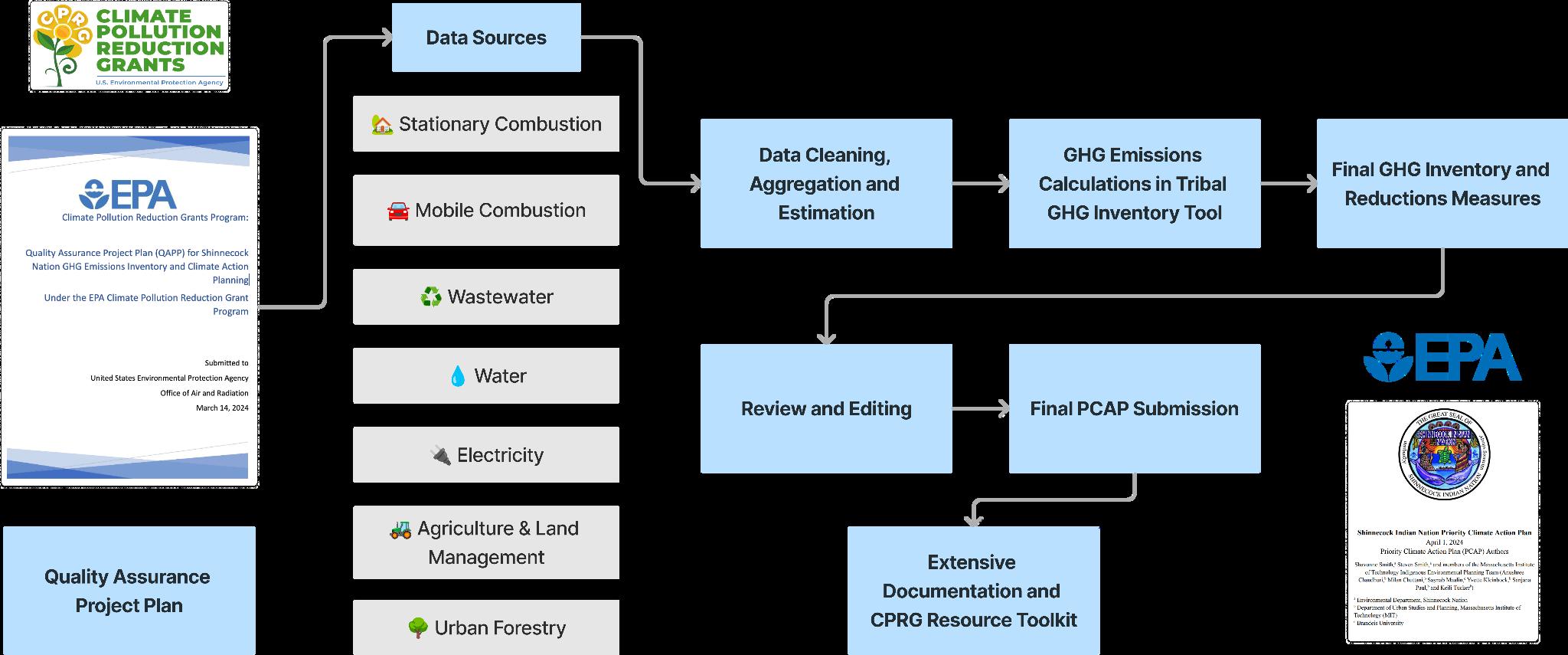
TheoverallprocessweusedincompletingtheCPRGdeliverablesisoutlinedbelow.Although wewouldhavelikedtofollowalonger,moreiterativeprocessforconsultingstakeholdersand meaningfullycompilingdata,theinflexibledeadlineofApril1stforthePCAPlimitedourability toconductfurthercommunityengagement.However,wehopethatthetoolkitandresources compiledwillempowertheNationtocontinuethisworkinlinewiththeirvaluesandpriorities relatedtoclimateandlanduseplanning.
FindingsandNextSteps
FortheShinnecockNation,acomprehensiveemissionsinventorybysource(calculatedusingthe generalmethodologyabove)isprovidedinthetableandgraph.Thepercapitaemissionsfor ShinnecockNationmembersin2023was1.74MTCO2e,althoughthiscalculationisbasedon estimates,andseveralScope3emissionssources,suchassolidwaste,arenotincluded.Thefinal PCAPhasbeenpublishedonlinebytheEPAandcanbefoundatthislink.
Figure 2 A diagrammatic representation of our process and methodology in developing the QAPP, GHG emissions inventory, PCAP, and final resource/documentation toolkit
TheShinnecockNation'sfinalPCAPandGHGEmissionsInventoryidentifiedfivekeyGHG reductionmeasuresthatalignwiththeNation'sexistingprioritiesandvalues.Thesemeasuresnot onlycontributetoreducingemissionsbutalsoprovideadditionalbenefitstothecommunity
Goal1:Increaserenewableenergygeneration
Byinstallinga600kWsolarcommunitymicrogrid,theShinnecockNationcanavoid963,600 annualkWhofelectricityconsumption,resultinginanestimatedreductionof673MTCO2e. Thisproject,estimatedtocost$1.4million($2,080.24perMTCO2e),willcontributeto poweringexistingresidentialandinstitutionalbuildings.Beyondemissionsreductions,the microgridwillreducepublichealthrisksfrompoweroutages,provideresilient,local,and affordablepowersystems,reduceutilitybills,andofferworkforcetrainingopportunitieson emergingtechnologies.
Goal2:Decreasevehicularemissions
ElectrifyingtheTribe-ownedvehiclefleetisestimatedtoreduceemissionsby68.4MTCO2e, affectingtheMobileCombustion(Scope1)category.Withanestimatedcostof$390,000
Figure 3 Total emissions calculated by source
($5,701.75perMTCO2e),thismeasurewillimproveairqualityontheterritory,encourageEV usebydemonstratingitsviability,andprovideworkforcetrainingonemergingtechnologies.
Goal3:Reducebuildingenergyconsumption
Weatherizingandelectrifying100%ofinstitutionalbuildingsand70%ofallhomesisprojected toreduceemissionsby682.36MTCO2e,affectingtheStationaryCombustion(Scope1)and Electricity(Scope2)categories.Thetotalestimatedcostforthismeasureis$2,884,759($4,228 perMTCO2eupfrontcosts).Inadditiontoemissionsreductions,thisgoalwillcreate constructionjobs,reduceutilitybills,andprovideworkforcetrainingonemergingtechnologies.
Goal4:Integratedwastemanagement
Expandingrecyclingandcompostingprograms,alongwithconsideringthefeasibilityof constructingastand-aloneanaerobicdigesterforbiogasproduction,isestimatedtoreduce emissionsby195.45MTCO2eintheWasteProduction(Scope3)category Withanestimated costof$1,200,000($6,139.70perMTCO2e),thismeasurewillcreatejobsfortribalmembers andgeneraterevenuesfromthesaleofrecyclablematerials.
Goal5:Treereplanting
PlantingtenacresoftreestoreplacethoseremovedduringdevelopmentintheWestWoodsis estimatedtoreduceemissionsby1,000MTCO2eintheUrbanForestry(Scope3)category, assumingmaturingofforestedacreageovertime.Withanestimatedcostof$300,000($300per MTCO2e),thismeasurewillmaintainapleasantenvironmentforTribemembers,decreaseheat islandeffects,provideshade,andimproveairqualityontheterritory.
ThesefivegoalsalignwiththeShinnecockNation'sexistingvaluesofSelf-sustainabilityand Sovereignty,ProtectingtheLand+Culture,andGrowth+Adaptation,asdiscussedfurtherinthe participatorymappingsections.Byinvestinginrenewableenergy,reducingvehicularemissions, improvingbuildingenergyefficiency,managingwasteeffectively,andreplantingtrees,the Nationcanreaffirmitscommitmenttothesevalueswhileaddressingclimatechangeand enhancingthewell-beingofitscommunity.
CPRGToolkit
ThroughouttheprocessofdevelopingtheCPRGdeliverables,includingtheQualityAssurance ProjectPlan(QAPP),GreenhouseGas(GHG)EmissionsInventory,andPriorityClimateAction Plan(PCAP),ourteamrecognizedtheimportanceofthoroughdocumentation.Giventhe expeditedtimelineforcompilingthesedeliverablesandtheShinnecockNation'songoing collaborationwithvariouspartners,itwascrucialtocreateacomprehensivetoolkitthatwould enabletheNationtocontinuethisworkseamlesslyinthefuture.
Toensurethelongevityandusabilityofourwork,wecompiledallrelevantmaterials,data,and methodologiesintoawell-organizedDropboxfolder(seescreenshotontherightbelow).This foldercontainsEPAtemplates,teamemails,thefinalGHGEmissionsInventorytool,the acceptedPCAPdocument,thefinaldraftoftheQAPP,andsubfoldersforeachemissions category.Additionally,weincludeda10-minutevideodemonstrationofhowtouseandupdate theTribalGreenhouseGasInventoryTool(TGIT)andanextensivewrittendocumentationfile thatprovidesexplanatoryvideos,screenshots,anddetailedinstructions.Thescreenshotonthe leftbelowshowcasesanexampleanimationfromthetoolkitdemonstratinghowtoutilizethe EPA'sGHGEquivalenciesCalculator.
4 An example animation included in the final documentation and resources toolkit that demonstrates how to use the EPA’s Greenhouse Gas Equivalencies Calculator
5
of all the materials that were handed off to the Nation in our shared Dropbox folder, organized by emissions category and with all final documents in the main folder
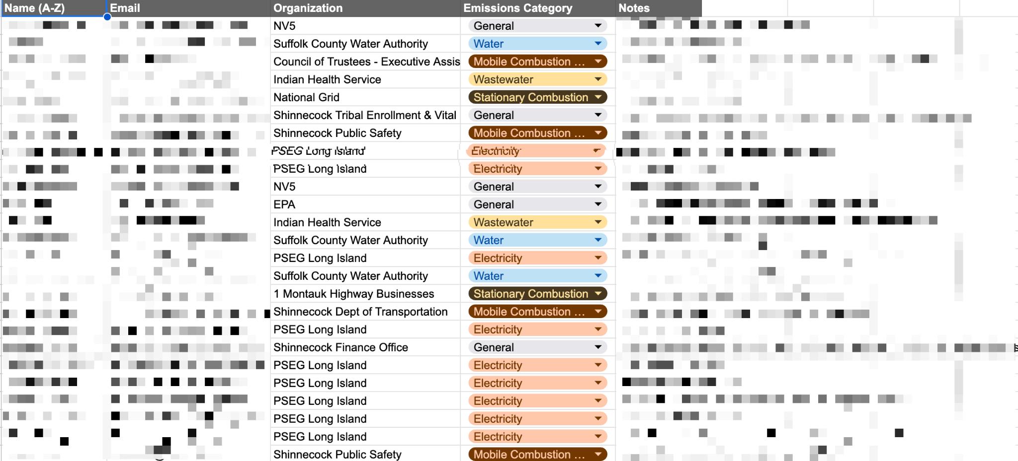
Moreover,wedevelopedacomprehensivecontactsdatabase (PCAP_Contacts_Database_050124_AC.xlsx)thatcontainsthecontactinformation, organizationaltitles,andemailaddressesofallindividualsandgroupsconsultedduringthe PCAPandGHGemissionsinventoryprocess(seethescreenshotbelow).Thisdatabasewill serveasavaluableresourcefortheShinnecockNationwhencollaboratingwithpartnersand stakeholdersinthefuture.
Figure
Figure
A screenshot
Figure 6. A contacts database showing all of the stakeholders we reached out to, if/how they were able to help us, and email addresses and organizational information (blurred for privacy reasons)
WehopethisextensiveCPRGtoolkitcansupportShinnecockNationastheycontinuetheir climateactioneffortsandexpandcollaborationswithotherpartners.Thedocumentationand organizationofourworkwillfacilitateasmoothtransition.
ParticipatoryMappingandDocumentationofLandUsePlanning
Ourparticipatorymappingandlanduseplanningdeliverables focusedonthreeparts:
Part1-Developinganinteractive,onlinelanduseplanningmaptosupportTribecommunication anddecisionmaking;
Part2-Developingaparticipatorymemorymappingprocessandaccompanyingdigital storymaptoensuretherespectfulandcontinuedcurationofcommunityknowledgeaboutthe land.Conversationsfromtwopilotparticipatorymappingworkshopsguidedthecreationofa templateShinnecockValueswheelandaiterative,four-partcycleforincorporatingthesevalues intoplanningefforts.WehopethesetoolshelpTribemembersframefuturelandusedecisions andtheiraccompaniedtrade-offs.
Part3-DevelopingaseriesofcasestudyscenariosthathighlighthowShinnecockValuescanbe representedthroughfuturehousingsiteplanning,visioninganddesign.
BackgroundonMappingDevelopmentandDataSources
Ourfirstpriorityinthemapping-relateddeliverableswastoidentifyaplatformthatwouldmeet theNation’slong-termneedsandalignwithitsdataownershipconcerns.Followingourinitial outlinedScopeofWork,inlateFebruaryandearlyMarch,ourteamprovidedShinnecockNation withanoverviewofrecommendedplatformoptions,includingArcGISOnlineDashboard+ ESRIToolkit,MapboxGL,RShiny+Leaflet,Carto,Felt,andQGISDashboard.Weoutlinedthe prosandconsanddetailedkeyconsiderationssuchascost,datamanagement,easeofuse, privacyanddataownership,long-termmaintenancecapabilities,andaccessibilityacross differentdevices.Basedondiscussionsandinputfrommultipledepartments,theFeltplatform waspreferredduetofamiliaritybytheteam,customizationabilities,easeanddiversityofuses, andaffordablepricing.Thereisalsoapossibilitytoincludeadditionalinformationthatmaybe mappedusingQGISandintegratedintotheFeltplatform.Withaplatformselected,ourteam builtaninitialproofofconceptandsetupademowiththeFeltteamtobetterunderstand availablefeaturesundereachpricingplan.WecoordinatedwiththeShinnecockNationtohelp setupanaccountandpaymentinformationthatcanbeeasilytransferredwithfullownershipto theNationaftertheconclusionofourproject.
Part1:LandUseMapping
Basedonconversationswithourpartnerleads,PhillipBrownandShavonneSmith,duringthe initialsitevisitinFebruary,weidentifiedvariousareaswheretechnicalassistancewithmapping couldbehelpful.InitialdiscussionswithdepartmentsofHousing,Transportation, Environmental,andCulturalResourcesduringtheFebruary2024SiteVisitoutlinedthe followingpotentialusecasesforasharedinteractivemappingplatform:
(1 Housing)provideasurveyofexistinghousingstock,visualizepotentialnewhousing sites,suchasWestwoods;
(2 Transportation)mapoldpathways,visualizepotentialtransportationneedsif Westwoodsdevelops,illustrateconnectionsbetweenkeypointsontheterritory;
(3 Environmental)mapfloodvulnerability,identifyhousesatrisk,mapenvironmental resourcesandheritage,inventorycoastalresourcesanddunes,sitepotentialrenewableenergy projects;
(4 Cultural)createarepositoryforelderinterviewsandculturalinformation,involve youthindatacollectionprocesses,andmapknownculturalsitesandpathways.
Wedevelopedalandusemaputilizingacombinationofdatalayersalreadyavailableinternally intheNation’sgovernmentandthosethatarepubliclyavailableonline,suchasFederal EmergencyManagementAgency(FEMA)floodrisklayers.Spatialanalysistoolswereaddedto visualizevariousopportunitiesandchallengesintheTerritory,suchasbufferzonesaround existinghousingstockandareasandhomesatriskofsevereflooding.Anexampleofoneofthe analyticalmapsdevelopedintheFeltplatformisprovidedbelow.
Part2:ParticipatoryMappingWorkshop,SiteVisitTakeaways,andMappingTools 1) AbouttheProcess:MemoryMappingandWorkshops
Participatorymemorymappingisavaluabletoolforengagingcommunitiesinplanning processesandfacilitatingthesharingofdiverseperspectivesandexperiences.AsKaren Umemoto(2005)emphasizesinherworkonreparativeplanning,memorymappingcanhelp developasharedunderstandingofthestrengthsandchallengeswithinaparticularspace.By conductingparticipatorymappingintheShinnecockNation,weaimedtopilotaprocessfor visualizingpastandpresentstates,stories,andfuturevisionsfortheNation'slanduseplanning goals.ThisprocesshasbeenhandedovertotheTribeforcontinueddevelopmentintheformofa templateStoryMap(includingstoriesfromthetwocommunitymemorymappingfocusgroups describedbelow)andaparticipatorymappingfacilitationtoolkit.
Memorymappingoffersanopportunitytoelevatetheleadership,perspectives,andwisdomof peoplemarginalizedbystructuralviolenceandinstitutionalizedracism(IndigenousMapping Workshop,2020).Traditionally,mappinghasbeenusedbypeopleinpowerasatoolof oppression,includingerasingIndigenoushomelandsorraciallyredliningneighborhoods. However,community-ledmapscanalsobetoolsforliberation,visioning,andcoalitionbuilding, especiallywhenthepowertobuildthemisdemocratizedtothosemostaffectedbyinjustice.
Figure 7 Screenshot from the Felt platform visualizing buffers around houses that are near flood zones, with flood hazard data from FEMA
Byfocusingontheprocessofcreatinganannotatedmapratherthansolelyontheoutcome, participatorymappingcanserveasatoolforcoalition,organizing,andbuildingempathy.Theact ofsharingmemoriesofaneighborhoodcanhelppeopleexploredivergingperspectivesand experiencesandpotentiallyorganizearoundacommonvisionforsocialchange.Moreover, honoringsharedknowledge,perspectives,andexperiencesasgiftsiscrucialinparticipatory mapping,followingguidelinesoutlinedbytheUMassCenterofBraidingIndigenousKnowledge Systemsthatemphasizedevelopingrelationsandreciprocalknowledgesharingasacriticalform ofjustice.
TwoteammemberswereinvitedtovisittheShinnecockNationonApril13thduringtheNation's annual Okhe/EarthDaycelebrationhostedbytheShinnecockEnvironmentalDepartment.The teamtabledattheopenareaalongwithanumberofotherbooths,encouragingcommunity memberstostopforashortwhiletooutlinetheirideas,memories,stories,andassociationswith thelandonlargeprint-outsofmaps.
Inadditiontotheopentablingworkshop,theteamheldtwosmallerfocus-groupstyle participatorymappingworkshops,onewithTribalgovernmentleadersandanotherwith interestedcommunitymembersidentifiedduringtheopentablingsession.Thesesessionswere approximatelytwohoursindurationandfollowedasemi-structuredprocesstofacilitate meaningfulengagementandknowledgesharing.
Theworkshopsbeganwithanicemelterquestion,welcomingandthankingallparticipantsfor joiningtheactivity.Facilitatorssharedtheirgoalsfortheactivity,outlinedconfidentialityand privacyconsiderations,andprovidedoptionsforparticipantstoprovideconsentbyoptinginor outofsharingtheirexperiencesandphotosonthefinalproposal.
Next,thefacilitatorsorientedcommunitymemberstotheprintedmapbypointingoutcardinal directionsandsignificantlandmarksinthearea.Duringthecontextportionoftheexercise, participantssharedexperiencesorstoriestoprovidecontexttowhotheyareandtheir relationshiptothechosentopic.Facilitatorsfollowedannotationguidelinestoensureconsistency indocumentingthesharedknowledge.
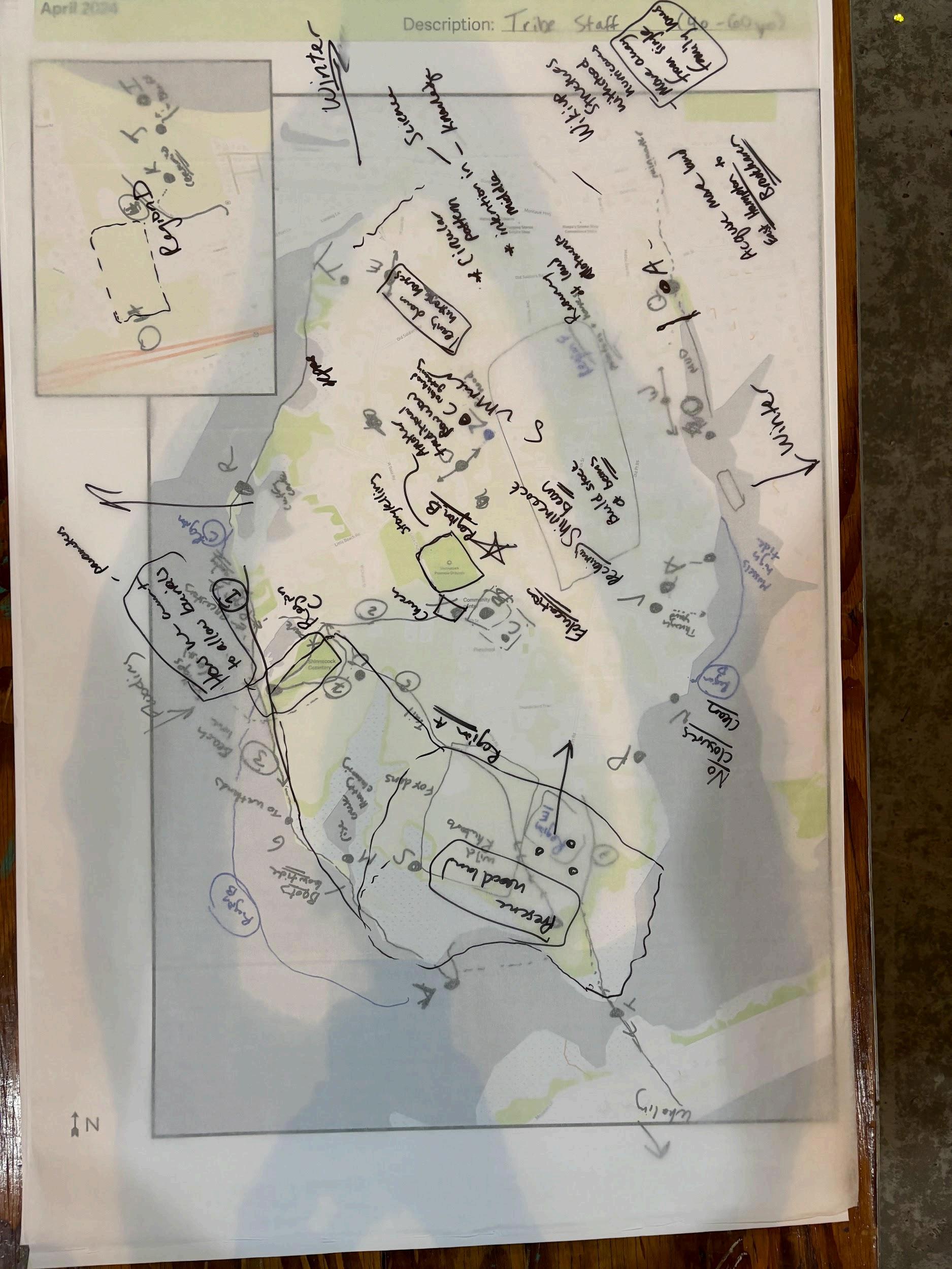
Inthesecondportionoftheactivity,participantsweregiventheopportunitytodiscusswhat valuestheywishtobepassedoninthewaythatthelandisapproachedandimaginewhatthe landcanlooklikefortheirgrandchildren’sgrandchildren.Tracepaperwasplacedoverthemap, allowingparticipantstoseetheirvisionsoverthecontextmapwhilestillhavingablankcanvas toworkon.Thisvisioningexercisefocusedonmappingparticipants'visionsanddesiresforthe future,aswellasconcernsandfears.
Theworkshopsdidnotincludeaudioorvideorecording.Ongoingandinformedconsentwas obtainedfromallparticipants.Detailednote-takingwasundertakentoassociatethelocationson themapwithspecificquotesandstoriestohelpwithdigitizingandsensemakinglater.A communitymemberwasalsotrainedtofacilitatetheseworkshopssothattheycanbecontinued goingforward.
2) OurOutcomes
ParticipatoryLandUsePlanningProcess
TheEarthDayvisitandworkshopsemphasizedasenseofconcernsharedbyShinnecock communityleadersasaresultoffacingincreasedenvironmentalchallengesandnavigating conflictingprioritiesofexpandingresidentialcapacityandpromotingeconomicdevelopment whilepreservingculturalandecologicalpractices.Thesetakeawaysrevealedadesirefora platformthatcouldpreservethememoriesandTraditionalEcologicalKnowledgesharedwithin theworkshopsessions,aswellasatooloraprocessthatcouldfacilitatedecision-making groundedinShinnecockpriorities,histories,andvalues.
Asaresult,ourteamformalizedaparticipatorymappingprocesstosupportShinnecock’sfuture landuseplanning.Inadditiontothememorymappingworkshopsdescribedabove,ourteam digitizedtheresults,synthesizedkeyvaluesandpriorities,andvisualizedalternativeplanning
Figure 8 Past/present stories map generated by the workshop
Figure 9 Future visions map generated with overlaid trace paper in the workshop
scenariosgroundedintheseprinciples.Theoutcomesdescribedbelowrepresentaninitial engagementwiththisparticipatorylanduseplanningframework,whichwillbehandedoffto ShinnecockNationwithacomplementarytoolkittosupporttheirongoingplanningefforts.
ACircleofValues
Theparticipatorymappingworkshopsandsitevisityieldedvaluableinsightsandthemesthat weresynthesizedintosevenoverarchingvalues(seethefigurebelow).Thesevalues,which includerestoringwhathasbeenlost,self-sustainabilityandsovereignty,protectingthelandand culture,honorandrespect,growthandadaptation,connectionandkinship,andknowledgeand memory,wereusedtoinformthestorymapandcasestudydescribedinlatersections.
Figure 10 Diagram illustrating participatory land use planning cycle
Participantssharedtheirobservationsofchangessincechildhood,expressinganawarenessof culturalandecologicalheritagethathasbeenlostandcannotberestored,aswellasalongingfor whathasbeentakenandlieswithinreach.Theimpactsofcolonizationonpresent-dayhealth, foodpractices,housingtypologies,developmentapproaches,territoryboundaries,and environmentalpressureswerealsodiscussed.
Acentralthemethatemergedfromtheworkshopswastheimportanceofpassingdownvalues throughvisioningthefutureoftheland,withparticipantsemphasizingthesignificanceof respect,honor,self-sustainability,connection,andkinship.Thesevaluesserveasguiding principlesfortheShinnecockNationastheynavigatethechallengesofpreservingtheirculture andtraditionswhileadaptingtothechangingworldaroundthem.
Community+StorytellingMap:PastandFutureVisioning
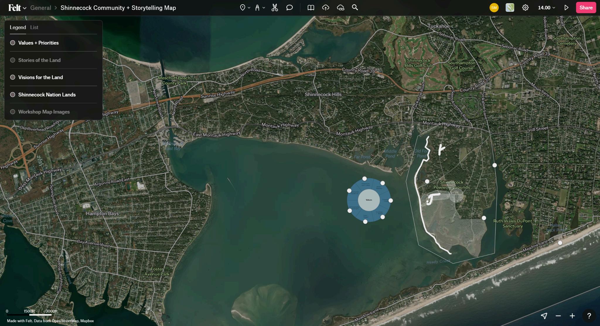
Theannotatedmapsandtranscriptsfromparticipatorymappingworkshopsweretransferredinto theFeltplatform.TheresultingCommunity+Storytellingmapwillserveasadigitalarchiveand educationaltoolthatpreservesTribalknowledgeandhistoryandcancontinuetoevolveasa collaborativeplatformforstorytellingandvisioning.Clickingoneachline,region,andmarker opensquotesand/orphotosprovidedbytheparticipantsaboutthespace.Thesecanbemoved, addedto,andmodifiedbyTribalmembersandstaffwhofacilitatefutureworkshops.
Figure 11 Circular representation of seven overarching values identified through the participatory mapping process
12 Felt platform showing ‘Stories of the Land’ map layer and identified Values + Priorities
13 Felt platform showing ‘Visions for the Land’ map layer and identified Values + Priorities
Figure
Figure
Part3:AdaptiveScenarioPlanningforaHousingDevelopmentnearCommunity
ShavonneSmith,PhillipBrownandtheTribalgovernmentexpressedinterestintranslating principlesontheShinnecockValuewheelintohousingsiteplansthatcenterandamplify communitywisdomandprinciples.Tofacilitatethisconversation,wecreatedaprocessforthe Tribetobuildoutthesesiteplans,perspectives,Indigenousplanningprecedents,andrenderings usingotherfreeandaccessibleonlineresources.Thescenariositeplansareallsavedinthe ShinnecockFeltaccount,alongwiththeparticipatorystorymapsandlanduseplans,withthe goalthattheycanallcontinuetobeupdatedtogetherasnewcircumstancesariseandcommunity focusgroupdiscussionscontinue.
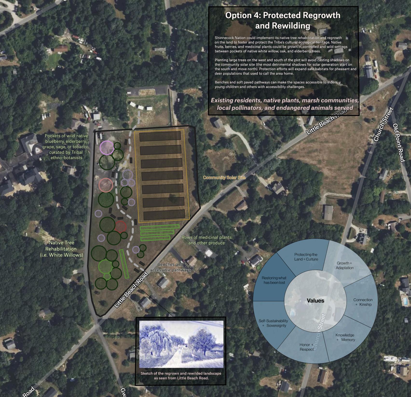
Shinnecockcollaboratorsidentifiedaparceloflandnearthecommunitysolarsitetouseasa casestudyforfourpotentialscenarios:1)continuingthesingle-familyhousingallocation process,2)expandingtosmallmixed-densityhousing,3)developinglargertowers,and4) fosteringnaturalregrowththrougharewildingapproach,eachwhichhighlightasetof Shinnecockvalueswhileexploringtheirtensionsandtradeoffs.Thesescenariosweredesignedto provideacomprehensiveandflexiblevisionforthecommunity'sfuturehousingneeds.These scenariosarecompiledandvisualizedinFelt,sotheycancontinuetobedeveloped,modified, rearrangedbytheTribeandthroughparticipatoryprocesses.
Process
Eachscenariocasestudyincludesasiteplanwithfootprintsfortreeplantings,buildingmasses, nativeplantnurseries,rewildingzones,andcommunitygatheringspaces.Eachoftheseitemsis createdinFeltandcanbeeasilymoved,resizedandmodifiedbytheTribestaff.Boxesare includedwithlinkstoexistingprecedentsofsimilartypologies,suchasmoderate-sized apartmentbuildings,largeresidentialtowers,orgreenhousesfornativeseedbanks.All precedentsareworkscreatedbyorincollaborationwithIndigenousarchitects,planners,or engineers.
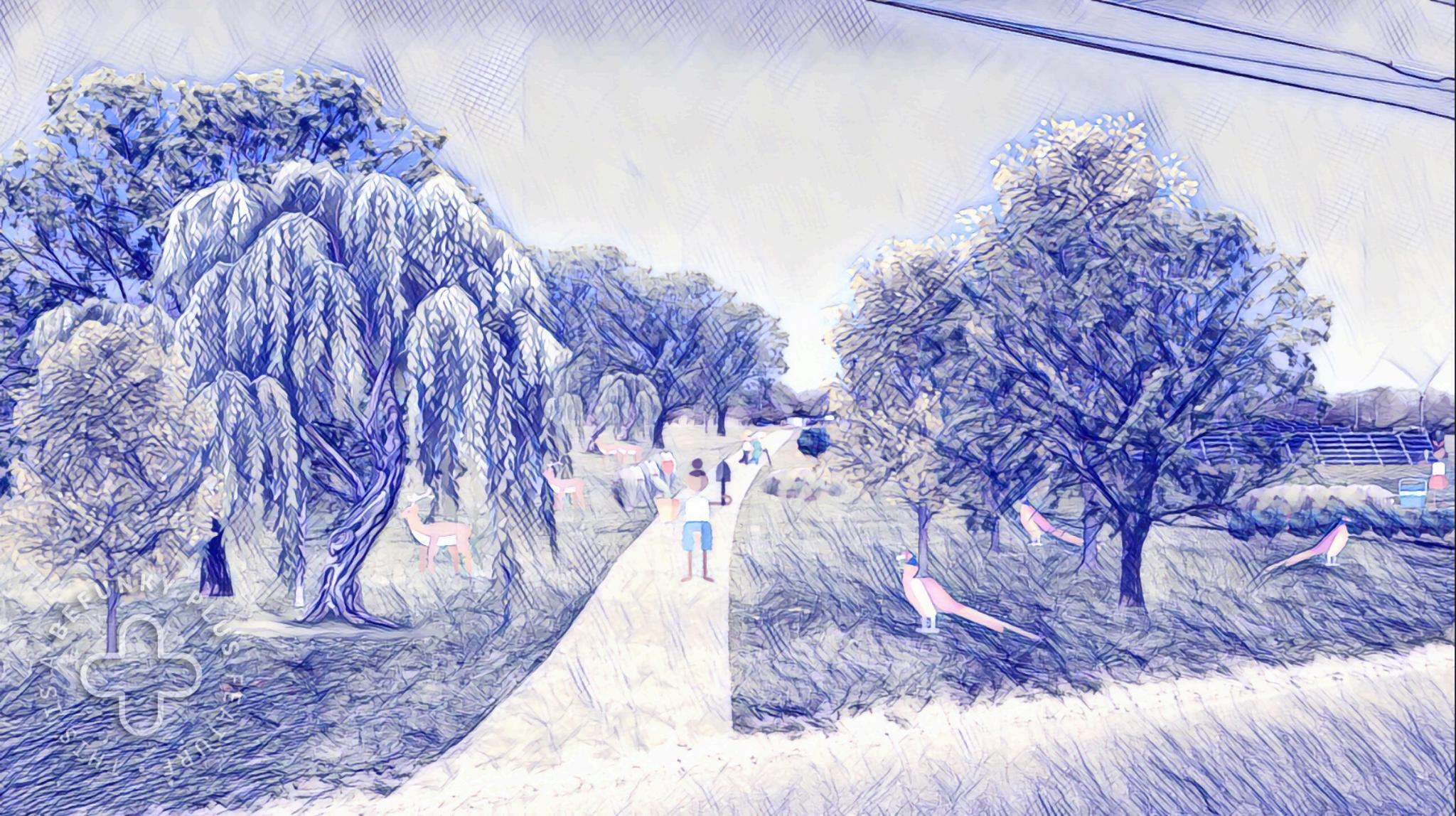
Thescenariosalsoincludeadraft,sketchsiteperspectives.Wechoosetoincludesketchesrather thanrealisticrenderingsasameanstohighlightthatthesedecisionsareflexibleandcancontinue tobemodifiedthroughaco-designprocess.Previousresearchsuggestedthatrealisticsite perspectivescanoftenmakecommunitymembersbelievethatsitingdecisionshadalreadybeen made,limitingopportunitiesforcollaborativeco-ownershipandleadingtomistrust.
Inaddition,itwasimportanttousthattheTribemaintainedfullownershipofboththescenarios andallaspectsoftheprocessforcreatingthem.Todothis,weusedno-costonlinetoolsfor creatingthesketches,removingtheneedforexpensivedesignsoftwarelikeIllustratorand Photoshop.EachsketchwascreatedfirstasaGoogleSlidecollageusingaphotoofthesiteasa backdrop,andfreelyavailableimagesandicons.Screenshotsofthecollagewereuploadedto https://www.befunky.com/create/photo-to-art/andautomaticallyturnedintoasketchinundera minuteusingtheir Pen Art 1 tool.Thetoolalsoremovesdetails,styling,andimperfectionsinthe
collagesoviewerscanfocusonjustadepictionofthemainidea.Communitymembers,Tribe staffandotherscanupdatethesketchesbymovingfeaturesontheslideandre-uploadingthe screenshot.
BelowaretwoexamplesofthesitescenarioscreatedinFelt.
Figure 14 Scenario 4: (above) Protected Regrowth and Rewilding - imagines the space with pockets of wild trees, medicinal plants, pheasants, deer, and local pollinators Residents can walk freely along an accessible sidewalk The rendering embodies the values of “Restoring what has been lost”, “Protecting the Land and Culture” and “Self-Sustainability”; (bottom left) A screenshot of the rough Google Slide collage input into the sketching tool; (bottom right) A screenshot of the sketch tool output


Figure 15 Scenario 3: (above) Towers - imagines the land welcoming home many more Tribe members Each tower occupies minimal land ( 10,000 sqft footprint) leaving ample room for native tree growth, a community greenhouse, walking paths, and planters for blueberry, sage, and elderberry growth The rendering embodies the values of “Growth and Adaptation”, “Self-sustainability and sovereignty” and “Protecting the land and culture” Precedents for the towers come from Senáḵw, Squamish nation, and greenhouses from Eastie Farms and Indigeponics
ThevisioningscenariosdrawfromspecificwisdomsharedbyTribemembersduringthe ParticipatoryMemoryMappingandCommunityStoryMapprocess.Weencouragecommunity memberstoreferencetheStoryMapastheycontinuebuildingscenariosforthefuture.Including culturallysignificantfeatureslikewillows,pheasants,medicinalplantsalongwithclimate adaptationslikeretrofitbuildingsandsolarpanelscanhelpbuildtrustandunderstandingamong communitymembers.
Ultimately,thecasestudyaimstocentercommunityknowledgeandofferademocratized visioningprocessthatalignswithShinnecockNation’sideals.Itprovidesasustainableandjust approachtodevelopmentguidedbytheNation’svalues,histories,andevergrowingbodyof wisdom.Byprovidingadaptabletoolsthatareeasilyaccessible,thescenario-buildingprocess ensuresthatsustainabledesignremainswithinreachofallcommunitymembers.Moreover,this casestudyservesasaframeworkforotherdepartmentstocoordinatetheirlanduseplanning efforts,ensuringacohesiveandcomprehensivevisionthatreinforcescommunitycohesionand traditionallandpractices.
MappingToolkit
Inordertoeffectivelytransfertheprojectmaterialstoourpartners,wecreatedatoolkit, consistingofseveraltechnicaldocumentationfilesprovidinginstructions,videowalkthroughs, andtutorialsforhowtocreate,modifyandadvanceeachdeliverable.Avirtualtraining workshopwillbeheldtoensurelearningandunderstanding,tobuildonthein-personworkshop thatfocusedonparticipatorymapping.Wehavecompiledaseriesofexternaleducational resourcesonhowtocreate,modify,andencouragecommunityparticipationinFelt.Several customtutorialshavebeencreatedfocusedontheparticipatorymappingfacilitationprocess, creatingandeditingvisioningscenarios,andrunningspatialanalysessuchasoverlays,buffers, andmergesinourlandusemap.Thistoolkitisbeingshareddigitallywithkeystakeholders.
NextSteps
WewillconductaformalhandoverofthefinalizedtoolkittotheShinnecockNation.This processwillensurethatkeystakeholdersreceivecomprehensivedocumentationandtraining materials,providingthemwiththeresourcestheyneedforimplementation,aswellascontinued trainingforadditionalfacilitation.Additionally,adedicatedmeetingforpost-handoversupportis beingsetup.TrainingTribalcommunitymembersasmappingfacilitatorsiscrucialinensuring thetoolkit'ssustainability Thesefacilitatorswillbeequippedwiththeskillstoleadfuture participatorymappingworkshopsindependently
Wehopethatthefour-stepcycleofparticipatorymapping,digitization,valuegenerationand scenarioplanningcanserveasaself-sustainingprocessledbytrainedfacilitatorsandstaffinthe Tribe.Facilitatorswillalsobeencouragedtoadaptworkshopstovariouscommunitygroups, suchasyouthandelderstoensurediversevoicesareincludedinfutureplanning.
Lastly,expandingthescopeoftheparticipatorymappingprocesscanopenupnewpossibilities beyondlanduseplanning.Thisprocesscanbeappliedtoenvironmentalprotection,cultural heritagepreservation,andsustainableeconomicdevelopment.Sharingthetoolkitmethodology withotherIndigenousnationsandcommunitieswillalsofostercollaborativelearningandmutual support.
ConclusionandReflections
ThroughourcollaborationwiththeShinnecockNation,ourteamhashadtheprivilegeof supportingtheNation'seffortsinclimateactionplanningandlanduseplanning.Weassistedthe NationindevelopingkeydeliverablesfortheCPRGprogram,includingtheQAPP,aGHG EmissionsInventory,andaPCAP.TheseeffortsnotonlyhelpedtheNationmeetthegrant requirements,butwehopewillalsoprovideafoundationforfutureclimateactioninitiativesand expandedopportunitiesforaccessingadditionalCPRGfundsforimplementingpriorityclimate actions.
InadditiontotheCPRGdeliverables,ourteamworkedcloselywithPhil,Shavonne,andother Triballeaderstofacilitateparticipatorymappingworkshopsanddevelopinteractivemapping toolstosupporttheNation'slanduseplanninggoals.TheStoryMapandScenarioPlanning Tool,alongwiththeaccompanyingtechnicaldocumentation,serveasvaluableresourcesfor documentingtheNation'srichculturalheritage,visualizingpast,present,andfuturevisions,and guidinglanduseplanningdecisionsinalignmentwiththeNation'svaluesandpriorities.
Throughoutourwork,wegainedinvaluableinsightsandexperiencesthatwillshapeourfuture workasplannersandresearchers.Thisprojectnotonlyallowedustoapplyourtechnicalskills andknowledgetosupporttheNation'sclimateactionandlanduseplanningeffortsbutalso provideduswithadeeperunderstandingoftheimportanceofcapacitysharing,community engagementandleadership,andthehonoringofdiverseepistemologieswithinIndigenous communities.Inparticular,wewerehonoredandhumbledtobeincludedincommunity conversations,enjoyedtheprocessofco-learningandcollaborationwithmanymembersofthe Tribe,andareinspiredbyShinnecockNation’slongitudinalandstrengths-basedapproaches towardslandstewardship.
OneofthemostsignificanttakeawaysfromourworkwiththeNationwastherealizationofthe criticalneedforcapacitysharing,ratherthansimplycapacitybuilding.Aswecollaboratedwith theShinnecockEnvironmentalDepartmentandotherTriballeadersinmeetingthedeliverables fortheCPRGprogram,wewitnessedfirsthandthechallengesfacedbylocalgovernmentsand TribalNationsinmeetingthescaleandpaceofrecentfederalfundingopportunities.This experiencehashighlightedtheimportanceofaligningfundingopportunitieswithTraditional EcologicalKnowledgeandtheuniquecircumstancesofTribalNations,aswellastheneedfor moreflexibleandinclusiveapproachestoknowledgeproduction.
Movingforward,wearecommittedtoapplyingtheprinciplesofcapacitysharinginourfuture work,focusingonexpandingdocumentation,co-learning,andknowledge-buildingthataligns withthecommunity’svaluesandtimeframes.Inpossiblefuturepolicymakingroles,wewill advocateforthedesignoffundingopportunitiesthataremoreflexibleandengagealternative formsofknowledgeproduction,ultimatelycontributingtoamoredecolonialapproachto managinglocalclimaterisksandadaptationneeds.
Anotherkeytakeawayfromourcollaborationwastherecognitionofconflictingvaluesand prioritieswithintheShinnecockNation.Throughourparticipatorymappingworkshopsandsite visits,weobserveddifferinginterpretationsofpastandpresentlanduses,aswellastensions betweentheTribalgovernment’sprioritiesandthesometimesconflictingconcernsofresidents. Thisexperiencehastaughtustheimportanceofbeingbetterlistenersandbeingabletohold multiplevalidvantagepointsasnon-NativepeopleworkingwithIndigenouscommunities.We aregratefulfortheopennessandtrustshownbyallofthecommunitywehadthehonortomeet inallowingustounderstandtheseconflictingvaluesandinterests,andwewillcarrythese lessonsforwardinfutureparticipatorywork.
AswereflectonourexperienceintheIndigenousEnvironmentalPlanningclassandourwork withtheShinnecockNation,weareimmenselygratefulfortheopportunitytohavebeenapartof thisproject.Thetrustandopennessshownbythecommunity,aswellastheguidanceand supportprovidedbyourinstructors,havebeeninstrumentalinshapingourunderstandingof Indigenousplanningandtheimportanceofbuildinglong-termrelationships. Werecognizethatthereisstillmuchworktobedoneinindigenizingtheteaching,learning, research,andcommunityengagementeffortswithinourdepartmentandatMITasawhole. WhileinitiativesliketheIndigenousEnvironmentalPlanningclassandotherIndigenous communityplanningprojectsareastepintherightdirection,webelievethatgreater commitmenttolong-termpartnerships,prioritizingthehiringofIndigenousfacultymembers, andengagingwithglobalperspectivesonIndigeneityarecrucialforcreatingamoreinclusive anddecolonialapproachtoplanningeducationandpractice.
References
EPA, Chief Information Officer’s Policy Directive on Environmental Information Quality Policy available at EPAIT/IMDirective:EnvironmentalInformationQualityPolicy,Directive#CIO2105.3. AccessedonMarch1,2024.
EPA,ChiefInformationOfficer’sPolicyDirectiveonInformationTechnology/Information Management:QualityAssuranceProjectPlan(QAPP)Standard,Directive#CIO2105-S-02.0. Availableathttps://www.epa.gov/irmpoli8/quality-assurance-project-plan-qapp-standard. AccessedonMarch1,2024.
EPA,EPA-454/B-17-001, Quality Assurance Handbook for Air Pollution Measurement Systems, Ambient Air Quality Monitoring Program, Volume II.Availableat https://www3.epa.gov/ttnamti1/files/ambient/pm25/qa/Final%20Handbook%20Document%201 17.pdf.AccessedonMarch1,2024.
EPA,FactSheet:AreaswheredifferencesbetweenstateGHGinventoriesandtheEPA’sInventoryofUS GHGEmissionsandSinksbyState:1990-2020estimatesmayoccur Availableat https://www.epa.gov/system/files/documents/2022-03/fact-sheet-differences-epa-and-offical-state -ghgi.pdf.AccessedonMarch1,2024.
EPA,GreenhouseGasReportingProgram(GHGRP)athttps://wwwepagov/ghgreporting/data-sets AccessedonMarch1,2024
EPA, Inventory of U S Greenhouse Gas Emissions and Sinks: 1990-2021 at https://wwwepagov/ghgemissions/inventory-us-greenhouse-gas-emissions-and-sinks-1990-2021 AccessedonMarch1,2024
EPA, State and Tribal Greenhouse Gas Data and Resources at https://www.epa.gov/ghgemissions/state-and-tribal-greenhouse-gas-data-and-resources.Accessed onMarch1,2024.
EPA,FuelheatingvaluesandCO2emissionfactorsateCFR::40CFRPart98--MandatoryGreenhouse GasReporting.AccessedonMarch1,2024.
EPA,Globalwarmingpotentialsat https://wwwecfrgov/current/title-40/chapter-I/subchapter-C/part-98/subpart-A?toc=1 Accessed onMarch1,2024
USDAForestService,Greenhousegasemissionsandremovalsfromforestland,woodlands,andurban treesintheUnitedStates,1990-2019athttps://www.fs.usda.gov/research/treesearch/62418. AccessedonMarch1,2024
USDOT,HighwayStatisticsSeriesat https://wwwfhwadotgov/policyinformation/statistics/2021/vm1cfm AccessedonMarch1,2024
EPA,KeweenawBayIndianCommunityPriorityClimateActionPlanat https://wwwepagov/system/files/documents/2024-03/kbic-pcappdf AccessedMarch24,2024
EPA,GreenhouseGasEquivalenciesCalculator at https://www.epa.gov/energy/greenhouse-gas-equivalencies-calculator#results.AccessedMarch 25,2024.
Solarproof,600kWSolarSystemInformation-Facts&Figuresat https://quotessolarproofcomau/system-sizes/600kw-solar-system-information-facts-figures/ AccessedMarch25,2024
MichiganStateUniversity,CompostforSmallandMid-SizedFarmsat https://wwwcanrmsuedu/uploads/236/79117/Compost for Midsize FarmsQuickCourse8pgspd f AccessedMarch25,2024
NYSERDA,NewYorkBuildingElectrificationandDecarbonizationCostsat https://wwwnyserdanygov/-/media/Project/Climate/Files/2022-Comments/NY-Building-Electrifi cation-Cost-Full-Report-June2022 AccessedMarch25,2024
DOE,TribalEnergyEfficiencyandConservationBlockGrant(EECBG)Programat https://energygov/scep/tribal-home-electrification-and-appliance-rebates-program Accessed March25,2024
DOE,HomeElectrificationandApplianceRebate(HEAR)at https://wwwenergygov/scep/home-energy-rebates-frequently-asked-questions AccessedMarch 25,2024
DOE,TribalHomeElectrificationandApplianceRebatesProgramat https://www.energy.gov/scep/tribal-home-electrification-and-appliance-rebates-program. AccessedMarch25,2024


