

A station area adjacent to trail infrastructure, stable residential neighborhoods, and the addition of the West Lake Corridor could see new opportunities for mixed-use, infill, and neighborhood development.
Introduction
The Ridge Road TDD is situated in a stable and highly walkable neighborhood with historic commercial businesses along Ridge Road between the Indiana-Illinois State Line and Calumet Avenue. This station includes a modest parking area and is thought of mostly as a “kiss and ride” station. The town has been proactive in preparing for this station to be built and forthcoming investment, which sends a positive message to the development community. The town has completed a recent character-based zoning code (Town and Planning Design Collaborative) that provides appropriate TOD zoning. The town is also working on a complete streets project to improve the walkability and sense of place along Ridge Road and Calumet Avenue.
City Economic Goals (Town of Munster):
• Promote sustainable growth - concentrate at strategic redevelopment areas
• Support transit as critical to a prosperous town
• Create a legacy of unique parks and open spaces
• Grow as a hub of regional trail systems
• Strengthen infrastructure to meet future needs
• Redevelop old areas as walkable, mixed-use centers
Station Area | County Comparison

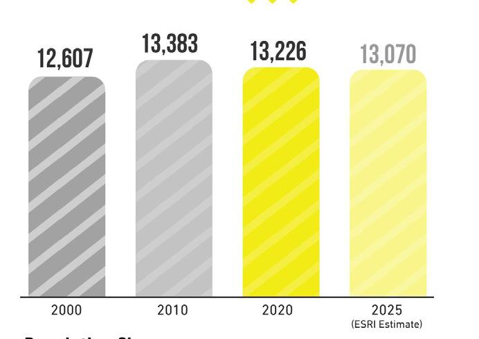
Population Change


Relevant Planning: RDA TDD boundaries (ongoing), Ridge Road and Calumet Avenue Streetscape Plan (2021), Munster Character-based Zoning Code (2019), West Lake TOD Plan (2017), NWIN RDA Comprehensive Strategic Plan (2016), and Comprehensive Plan (2010)
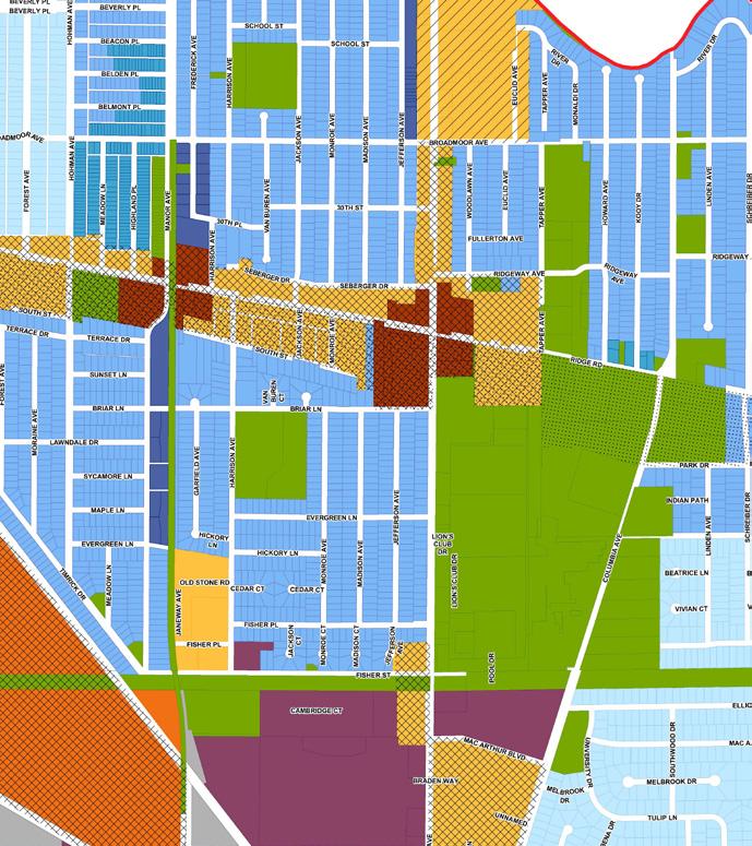
Zoning Ordinance Overview: The character-based zoning code is considered to be one of the most up-to-date of the communities being studied. The hybrid form-based approach allows for the appropriate mixing of uses and development densities to support TOD. Parking regulations are also favorable to enabling the density the community wants to see in this area. Some restrictions including required ground floor residential uses may need to be adjusted, and the community is amenable to this task to allow for market-rate development to occur with commercial ground floor uses. Minor changes to this code may be required, especially since the town is preparing a master plan for Ridge Road and Calumet Avenue streetscape improvements.
Public Engagement: To kick off the study of the Ridge Road TDD station area, a community bus tour and leadership work session were held in May 2019. An “On-Your-Own Gallery” made information available to the public to access and review throughout November and December 2020. In November 2020, a virtual public engagement session was held via Zoom video conferencing and Facebook Live, and 30 community members attended the session. The session was also posted to YouTube, which received 180 views. Materials from this engagement session were also posted to the project website.


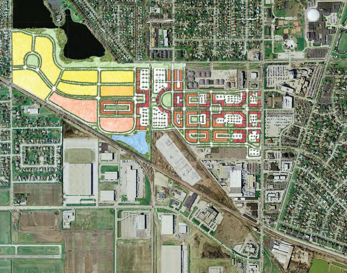
Comprehensive Plan (2010) concepts for a new Little Calumet River Park (top), town hall square (center), and redevelopment of the Lake Business Center and Lansing Country Club (bottom).


CD-5 - Urban Center
CD-4A - General Urban A
CD-4B - General Urban B
CD-4-R4 - Multi-family Residential
CD-3-R3 - 60’ Lot One Family and Two Family
CD-3-R2 - 60’ Lot One Family Residence
CD-3-R1 - 70’ Lot One Family Residence
Civic - Civic Zone
SD-M - Special District - Manufacturing
The analysis required for creating the boundary focused on floodplains and flood zones; land use patterns, including community anchors (destinations such as schools, parks, city halls, churches, etc.), commercial areas and corridors, residential neighborhoods near these places of activity, agricultural or preserved land, industrial land, and vacant or underutilized and publicly-owned land; TIF Districts and Opportunity Zone boundaries; and previous planned areas or other areas of interest identified by the town. Locating land uses and destinations in the station area provides a sense of where generators of economic activity, community gathering, and employment opportunities currently exist in the community. Locating vacant or underutilized and publicly-owned land and other areas of interest helps identify sites that may have a low barrier to redevelopment or have already been considered for redevelopment by the town and suggest where future development and investment could occur.
Existing land use patterns can inform opportunities for future investment that is compatible and complementary for the community. Major community anchors for the Munster Ridge Road station area included the Lansing Country Club, Town Hall, Munster Christian Church, the Monon Trail, and the Pennsy Greenway. Ridge Road and Calumet Avenue were identified as important commercial corridors, with the Calumet Center as a commercial node or destination. Clusters of residential areas exist along the Monon Trail to the south of Ridge Road and directly adjacent to the proposed station.
There is little available vacant or underutilized land in the station area. The Town of Munster currently owns land adjacent to the station area, as well as the public works facility at Fisher Street and Town Hall on Ridge Road.
Previously planned areas include a re-envisioned Town Hall Square including Town Hall and the Calumet Avenue/Ridge Road intersection, the Lake Business Center redevelopment that includes the Public Works site, and the Lansing Country Club. Areas of interest identified by the town include a portion of Calumet Avenue, including Calumet Center, and a few sites around the proposed station.

Due Diligence: Floodplain

Due Diligence: TIF District

Land Use: Community Anchors, Commercial, and Residential

Vacant and Publicly-owned

City Plans and Areas of Interest
HAMMOND

Calumet Center
Proposed Station
Road
Road
Munster High School
Lansing Country Club Community Hospital
The resulting TDD boundary for the Munster Ridge Road station area focuses on three future investment strategies: Corridor, Neighborhoods, and Mixed-Use Town Center. The major commercial corridors of Ridge Road and Calumet Avenue present opportunities for strengthening the commercial environment around the station. The Monon Trail is a strong asset as a recreational corridor along the future West Lake Corridor. Because the station area is immediately adjacent to existing single-family neighborhoods, development should incorporate appropriately-scaled residential opportunities from the higher density adjacent to the proposed station to lower density that blends in with the neighborhood fabric. Mixed-use development could be concentrated where the rail line intersects with the Ridge Road that will support higher levels of activity associated with the station.
TOTAL ACRES: 309.5 ACRES
CORRIDOR NEIGHBORHOODS MIXED-USE TOWN CENTER