


A station area with unique opportunities for tourism-oriented development and connectivity associated with State and National Park lands and a mix of development types along major roadways.
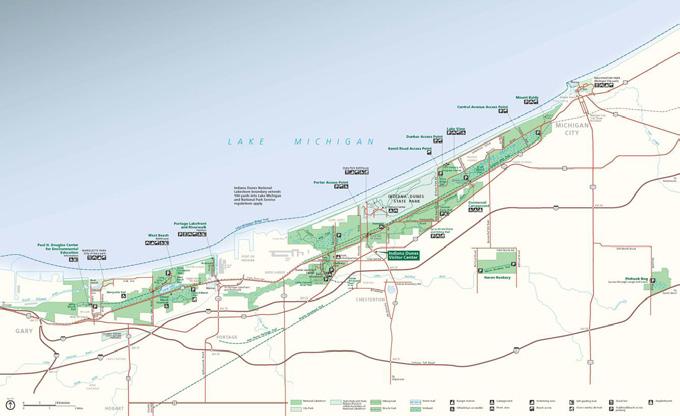
The Beverly Shores Station is included in the Double Track project and has the opportunity to increase development in the commercial district along US 12 in both the Town of Beverly Shores and the Town of Pines and to promote an increase in demand for services with the adjacency to the Indiana Dunes State Park. Beverly Shores is bounded by natural elements such as Indiana Dunes National and State Parks and Lake Michigan. The TDD boundary encompasses parcels in Beverly Shores and Pines and creates a unique opportunity for collaboration to preserve the character of the natural environment within the communities while promoting economic development and expanding the resources accessible for capital improvements.
• Allow small-scale mixed-use residential/business development in the commercial district and encourage development of small-scale businesses that contribute to the visual character of US 12
• Improve access along the commercial strip, helping to reduce traffic congestion and promote safety, and provide convenient access to goods and services
• Plan for capital infrastructure improvements, particularly sewers, pedestrian walkways, bike paths, and parking strategies, to reduce the obstacles of development for potential businesses
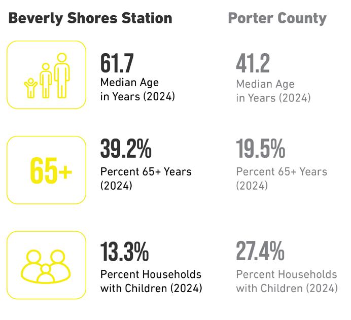

Relevant Planning: Beverly Shores Comprehensive Plan was updated in 2023. The comprehensive plan survey found that residents choose to live in Beverly Shores primarily for access to nature while maintaining proximity to metropolitan Chicago. Beverly Shores’s location and the area’s natural resources are two of the community’s greatest attractions. The core objectives of the plan focus on maintaining the natural environment; protecting the dune environments with low-density housing; supporting collaboration with surrounding entities like Indiana Dunes National Park and other community organizations; and enhancing the lives of residents and visitors.
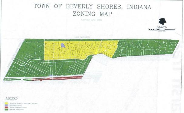
Zoning Ordinance Review: Beverly Shores Zoning Ordinance divides the town into districts, R: Residential District, C: General Commercial District, and G: Government District. The General Commercial District is described as: the area that borders U.S. Highway 12 North to the South Shore Line right-of-way and south to the corporate limits of Beverly Shores. Beverly Shores has recommendations to regularly review the permitted uses in the Commercial District to ensure the compatibility and needs of the town with viable businesses.
Public Engagement: Local leaders from Towns of Pines and Beverly Shores, along with RDA Staff and their consultants, jointly held a public engagement session on January 8th, 2025 at the Beverly Shores Town Hall. The meeting was well attended, and there was positive feedback and constructive discussion provided by those in the audience. The meeting was livestreamed via Zoom, and a recording has been posted to the RDA’s YouTube channel. A public comment period remained open through January 29th, 2025. All comments received were considered by leadership of the two local communities.
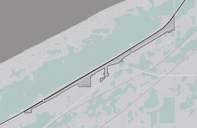
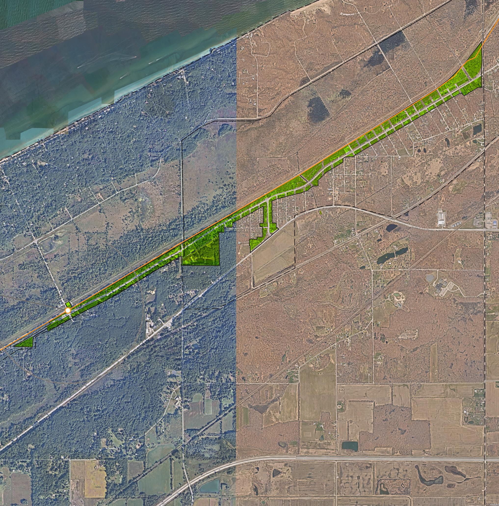
The analysis required for creating the boundary focused on floodplains and flood zones, watershed and wetlands; land use patterns, including community anchors (destinations such as schools, parks, city halls, churches, etc.), commercial areas and corridors, residential neighborhoods near these places of activity, agricultural or preserved land, industrial land, and vacant or underutilized and publicly-owned land; and previous planned areas or other areas of interest identified by the Towns. Locating land uses and destinations in the station area provides a sense of where generators of economic activity, community gathering, and employment opportunities currently exist in the community. Locating vacant or underutilized and publicly-owned land and other areas of interest helps identify sites that may have a low barrier to redevelopment or have already been considered for redevelopment by the Towns and suggest where future development and investment could occur.
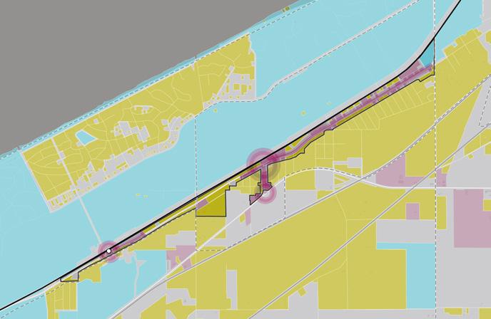
Existing land use patterns can inform opportunities for future investment that is compatible and complementary for the community. Beverly Shores is comprised of “the Island” landlocked by Indiana Dunes National Park and Lake Michigan, “the Strip” which includes the commercial district and many residential properties, the Government Center, and “the Lakeshore”. Major community anchors for the Beverly Shores station area include the Indiana Dunes National Park, Dunewood Campground, and many small neighborhood parks. Residential areas surround the station area and occupy much of the boundary as well as a large portion of lakefront land. The Beverly Shores Commercial District is comprised of all properties along US 12, from Lake Shore County Road on the east to the town’s western border. Commercial uses are clustered at the intersections of Broadway and US Highway 12 near the station in Beverly Shores and to the east of the station at Maple Street and US Highway 12 in the Town of Pines.
Several vacant or underutilized sites exist along the rail corridor within the boundary in both Beverly Shores and Pines. These sites are mainly vacant, undeveloped land ready for development. There are underdeveloped sites along US 12 scattered throughout the Commercial District. Because of the presence of national and state parks in the area, a significant amount of land is owned by the State of Indiana and the National Park Service.
The resulting draft TDD boundary for the Beverly Shores Station focuses on three future investment strategies: Commercial Corridor, Infill Development, and Neighborhoods. Commercial development should focus on creating walkable retail centers that service residents, commuters, and tourists. Multiple opportunities for hospitality and tourism-oriented development exist associated with the Indiana Dunes State and National Parks and the Lake Michigan waterfront. Significant regional investments in infrastructure and the proximity of both parks will improve the marketability of this area. This strategy can build upon the 2023 Comprehensive Plan, which supports developing these areas for the benefit of the community in a sensitive way that preserves and enhances the parks and other environmentally sensitive areas.