


DUNE PARK
A station area with unique opportunities for tourism-oriented development and connectivity associated with State and National Park lands and a mix of development types along major roadways.
Introduction
As part of the Double Track Project, the Dune Park TDD (297.2 acres) includes an upgraded station platform and parking lot. The station is located at the gateway to the Indiana Dunes near the Indiana Dunes State Park entrance and major exits off Interstate 94, the Indiana Toll Road, US 20, US 12, and Indiana 49. The proximity of this area to the Indiana Dunes National Park and Indiana Dunes State Park means that the TDD boundary can positively impact economic growth and development in this area for the benefit of commuters, residents, and visitors.
City Economic Development Goals:
• Embrace the value of the recreational setting and use it to guide development
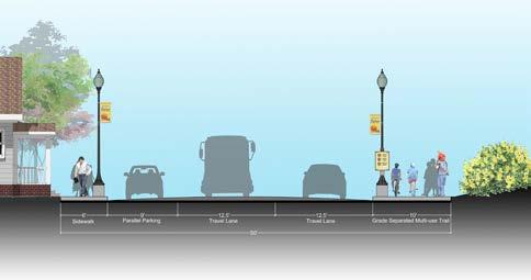
• Plan for capital infrastructure improvements, support favorable development along US-20 and IN-49, and encourage mixed-use, missing middle and upscale housing in the transit development district
• Develop creative strategies for parcels with the highest potential for community good
• Develop policies for the use of tax abatement and tax increment financing (including transit development district)
Station Area | County Comparison

Population Change


Relevant Planning: RDA TDD boundaries (ongoing), Downtown Porter Master Plan (2012), The Marquette Plan (2008), Porter County Comprehensive Plan (2023)
Zoning Ordinance Overview: The Town of Porter Zoning Ordinance zones much of the TDD boundary area as Single-Family Residential District (R-1) or Single- to Four-Family Residential District (R-3). North of the station along Waverly Road and Dunes Highway, as well as the In-49 and US-20 interchange, is zoned as Open Space District (OS). The Porter Beach Overlay applies to the neighborhood blocks along Lake Michigan that are zoned Single-Family Residential (R-1). Several parcels along the US 20 corridor have PUD zoning applied, either Residential, Business, or Industrial. Parcels zoned General Business District (B-3) also existing along the US 20 corridor. Downtown Porter is zoned primarily Single-Family Residential District (R-2) with the Lincoln Street corridor zoned at Central Business District (B-2), General Business District (B-3), and Light Industrial District (I-1).
Public Engagement: : To kick off the study of the Dune Park TDD station area, several virtual meetings were held with leadership beginning in January 2022. In August 2023, a hybrid in-person and virtual public engagement session was held in Porter and via Zoom video conferencing, and approximately 50 community members attended two sessions. The session was also posted to YouTube, which received 132 views. Materials from this engagement session were also posted to the project website.


Boundary Strategy
Due Diligence
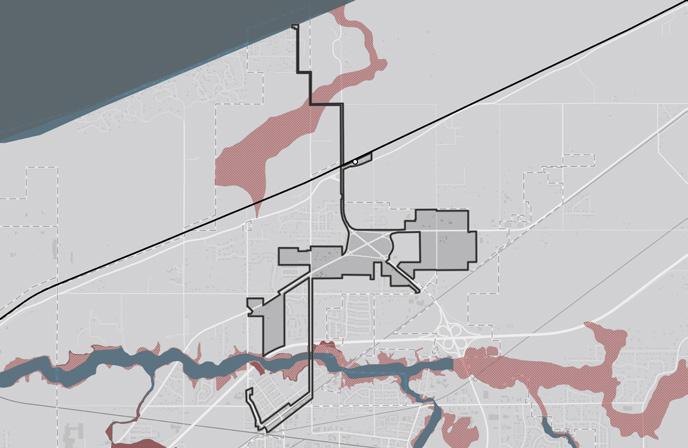
The analysis required for creating the boundary focused on floodplains and flood zones; land use patterns, including community anchors (destinations such as schools, parks, city halls, churches, etc.), commercial areas and corridors, residential neighborhoods near these places of activity, agricultural or preserved land, industrial land, and vacant or underutilized and publicly-owned land; TIF Districts and Opportunity Zone boundaries; and previous planned areas or other areas of interest identified by the city. Locating land uses and destinations in the station area provides a sense of where generators of economic activity, community gathering, and employment opportunities currently exist in the community. Locating vacant or underutilized and publicly-owned land and other areas of interest helps identify sites that may have a low barrier to redevelopment or have already been considered for redevelopment by the city and suggest where future development and investment could occur.
Land Use
Existing land use patterns can inform opportunities for future investment that is compatible and complementary for the community. The primary land use in the Dune Park station area is national or state park. Community anchors include the Indiana Dunes National and State Park north of the station, the Indiana Dunes Visitor Center and other parks along the Little Calumet River further south. A residential neighborhood exists to the southwest of the station with some small clusters of commercial uses along major roadways. Little to no major industrial sites exist in the vicinity of the Dune Park station.
Vacant, Underutilized and Publicly-owned Land
Several vacant or underutilized sites exist south of the station focused around the interchange at US 20 and IN 49. These sites are mainly vacant, undeveloped land ready for development. Because of the presence of national and state parks in the area, a significant amount of land is owned by the State of Indiana and the National Park Service.
City Plans and Areas of Interest
Previously planned areas include downtown Porter; previous plans, including the Downtown Porter Master Plan (2012) and the Porter Comprehensive Plan (2023), focus on improvements to Lincoln Street and increased development. Additional areas of interest include land surrounding the IN 49 and US 20 interchange and properties for potential future annexation.


Boundary Summary
The resulting draft TDD boundary for the Dune Park Station focuses on three future investment strategies: Commercial Corridor, Neighborhoods, and Waterfront. Commercial development should focus on creating walkable retail centers that service residents, commuters, and tourists. Multiple opportunities for hospitality and tourism-oriented development exist associated with the Indiana Dunes State and National Parks and the Lake Michigan waterfront. Significant regional investments in infrastructure and the proximity of both parks will improve the marketability of this area. This strategy can build upon the Town of Porter’s recent comprehensive planning strategy, which supports developing these areas for the benefit of the community in a sensitive way that preserves and enhances the parks and other environmentally sensitive areas.