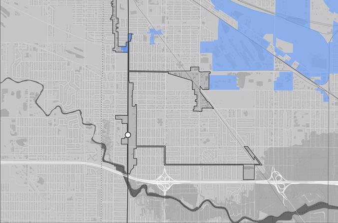


A station area adjacent to trail infrastructure, stable residential neighborhoods, and the addition of the West Lake Corridor could see new opportunities for neighborhood development and commercial corridor revitalization
Introduction
The South Hammond TDD is situated along the Monon Trail corridor in a stable neighborhood with major commercial corridors along 1655th Street, Hohman Avenue, Calumet Avenue, and Columbia Street. This area demonstrates multiple areas of infill development opportunities to enhance these commercial corridors. This station includes a parking area, but also has the potential to serve the residents immediately surrounding the new West Lake Line. This TDD also has the unique opportunity for trail-oriented development along two regional trail corridors, the Monon Trail and the Erie-Lackawanna Trail, making potential development in this area even more attractive.
City Economic Goals
• Supporting momentum tied to Downtown TOD and revitalization
• Walkable and trail oriented development within walkshed of TDD boundary linked to Downtown TOD
• Commercial focused development along major corridors
• Protection of existing single-family neighborhoods
• Activation of sites that could redevelop over time
Station Area | County Comparison

Population Change


Relevant Planning: RDA TDD boundaries (ongoing), West Lake TOD Plan (2017), NWIN RDA Comprehensive Strategic Plan (2016), Zoning Ordinance (2003 as amended), and Comprehensive Plan (1992)
Zoning Ordinance Overview: The ordinance dated 2003 but amended subsequently is an older style text ordinance that does consider transit-oriented development and trail-oriented development in the vicinity of the South Hammond Station Area along the Monon Trail and alignment of the future West Lake Line. Parcels along this north-south corridor are zoned as PUD between the future rail corridor and Harrison Avenue. The PUD zoning in this area allows for flexibility in future development to adapt to or respond to site qualities or restraints, such as the anticipated presence of commuter rail. Other areas within the TDD boundary are primarily zoned commercial, with a mix of commercial, industrial/manufacturing, and residential along the Hohman Avenue corridor approaching downtown.
Public Engagement: To kick off the study of the South Hammond TDD station area, a driving tour and work session were held in April 2023 with leadership. In September 2023, a hybrid in-person and virtual public engagement session was held in Hammond and via Zoom video conferencing, and approximate 35 community members attended the session. The session was also posted to YouTube, which received 22 views. Materials from this engagement session were also posted to the project website.


The analysis required for creating the boundary focused on floodplains and flood zones; land use patterns, including community anchors (destinations such as schools, parks, city halls, churches, etc.), commercial areas and corridors, residential neighborhoods near these places of activity, agricultural or preserved land, industrial land, and vacant or underutilized and publicly-owned land; TIF Districts and Opportunity Zone boundaries; and previous planned areas or other areas of interest identified by the city. Locating land uses and destinations in the station area provides a sense of where generators of economic activity, community gathering, and employment opportunities currently exist in the community. Locating vacant or underutilized and publicly-owned land and other areas of interest helps identify sites that may have a low barrier to redevelopment or have already been considered for redevelopment by the city and suggest where future development and investment could occur.
Existing land use patterns can inform opportunities for future investment that is compatible and complementary for the community. Much of the future rail corridor through the South Hammond TDD is vacant land associated with utility/rail surrounded by residential neighborhoods. Major community anchors in the South Hammond station area include several churches (such as Evangelical Lutheran Church Trinity, Greek Orthodox Church of St. Demetrios, Anthem Church), cemeteries, small neighborhood parks (such as Edison Park and Indi Illi Park), and schools. Major commercial corridors exist along Calumet Avenue, 165th Street, 169th Street, Hohman Avenue north of Kenwood Street, and Indianapolis Boulevard. Residential areas consist of tighter, urban neighborhoods surrounding the major commercial corridors. A cluster of large footprint industrial sites, such as Jupiter Aluminum Corporation, Hammond Group Inc., Meade Electric, and NIPSCO, occupy the area near existing railways east of Columbia Avenue and north of 165th Street.
Few significantly-sized vacant or underutilized land areas exist around the South Hammond station area, except for the undeveloped land immediately adjacent to the future rail corridor. for A few large industrial areas are vacant or underutilized and have potential for reuse. Beyond the station area are scattered individual vacant residential properties that would be appropriate for small-scale infill. Other properties owned by the City are operating for government/civic uses.


The resulting TDD boundary for the South Hammond TDD station area focuses on three future investment strategies: Corridor, Infill Development, and Neighborhoods. Due to the station area’s proposed location in a mostly residential area, future development nearest the station should focus on neighborhood-supportive uses and amenities. Infill commercial development and conversion of underutilized industrial sites would strengthen the major commercial corridors that already serve the community. A variety of residential types and scales on select development sites would further complement the surrounding existing neighborhoods.