Table 3-5, Corridor Operations, Alternative Comparison, 3-Lane versus 4-Lane .......................21
Table 3-6, Eastbound 95th Percentile Queue, ft .........................................................................22
Table 3-7, Westbound 95th Percentile Queue, ft ........................................................................22
Table 3-8, 95th Percentile Queues, Alternative Comparison, 3-Lane versus 4-Lane, ft ..............22
Table 3-9, Corridor Side Road Distances ..................................................................................23
Table 5-1, Summary of 3-Lane Corridor Alternatives 25
Table 5-2, Comparison of Alternatives 1 and 2 26
LIST OF FIGURES
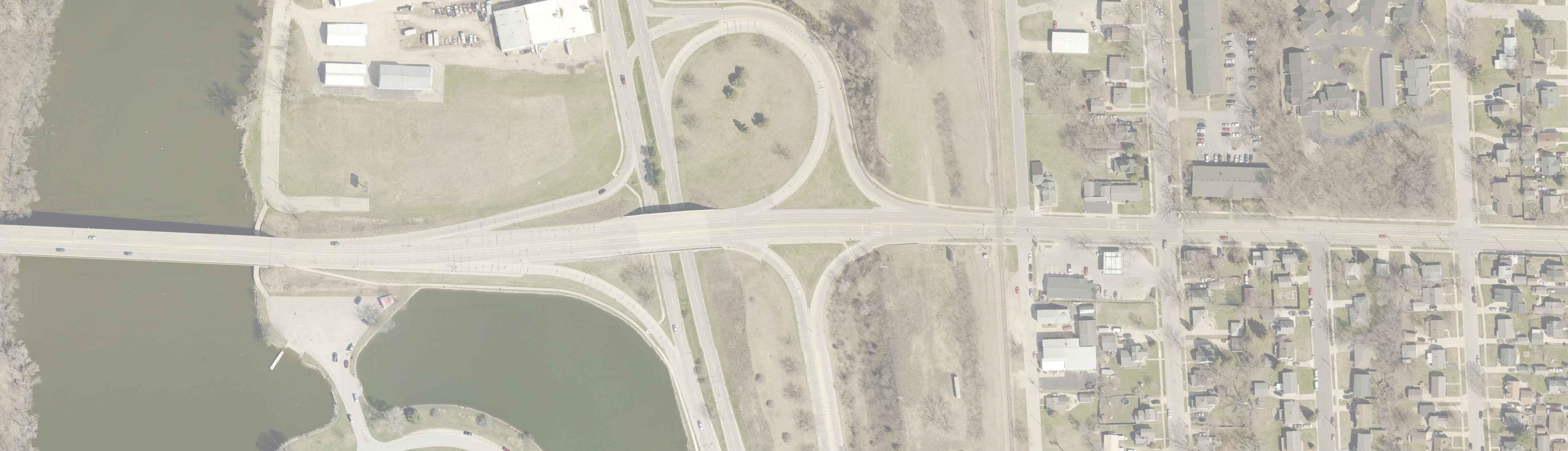
Figure 1-1, Study Limits and Existing Posted Speed Limits 5
Figure 1-2, JTS Bus Stop Locations 5
Figure 1-3, 2023
Figure 1-4,
Figure 2-4,
Figure
LIST OF EXHIBITS
Exhibit 1-1, 2023 Weekday Peak Hour Turning Movement Volumes
Exhibit 2-1. 4-Lane Alternative
Exhibit 2-2. 3-Lane Alternatives with Shoulders
Exhibit 2-3. 3-Lane Alternative with Wide Lanes
Exhibit 3-1, 2043 Weekday Peak Hour Turning Movement Volumes, Forecasted
Exhibit 3-2, 2023 Weekday Peak Period Operations, 4-Lane Alternative
Exhibit 3-3, 2023 Traffic Capacity/LOS Analysis, Existing Transportation System
Exhibit 3-4, 2023 Weekday Peak Period Operations, 3-Lane Alternative
Exhibit 3-5, 2023 Traffic Capacity/LOS Analysis, Improved Transportation System
Exhibit 3-6, 2043 Weekday Peak Period Operations, 4-Lane Alternative
Exhibit 3-7, 2043 Traffic Capacity/LOS Analysis, Existing Transportation System
Exhibit 3-8, 2043 Weekday Peak Period Operations, 3-Lane Alternative
Exhibit 3-9, 2043 Traffic Capacity/LOS Analysis, Improved Transportation System
LIST OF APPENDICES
APPENDIX A Traffic Volume Data
APPENDIX B Crash Data
APPENDIX C CEF Exhibits
East Memorial Drive Corridor Study
Chapter 1 - Introduction & Background City of Janesville, Rock County, Wisconsin October 2023
CHAPTER 1 – INTRODUCTION & BACKGROUND
1.1 INTRODUCTION
The City of Janesville (City) contracted with MSA Professional Services, Inc. (MSA) to analyze safety, traffic operations, and pedestrian and bicycle accommodations along a 0.9-mile segment of East Memorial Drive corridor, from the US 51 (North Parker Drive) ramp terminals to WIS 26 (Milton Avenue).
The analysis includes a review of operations at several intersections along the corridor, as identified by the City. The identified intersections included*:
1. Harding Street
2. Sutherland Avenue
3. Thomas Street
4. Cornelia Street
5. Eisenhower Avenue
6. Prairie Avenue
7. Richardson Street
* Intersection operational analysis at the ramp terminal intersections and the intersection with Milton Avenue were not included. Operational analysis and a deeper investigation into safety will be completed as part of separate projects at the respective locations.
Study of the selected intersections in addition to overall corridor operations were combined with City and public input to determine whether lane modifications along the corridor would be effective in increasing safety and reducing speeds along the corridor. The following report summarizes the results of the traffic and safety analyses, in addition to comments received, and makes an overall recommendation for future improvements
1.2 BACKGROUND & EXISTING CONDITIONS
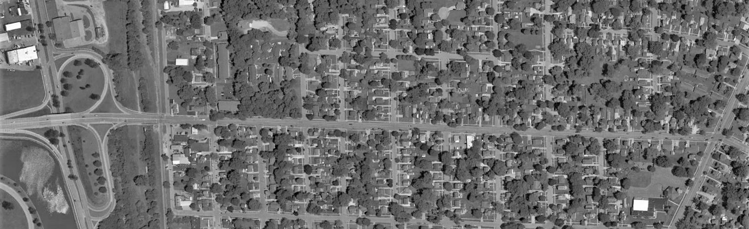
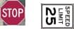
The East Memorial Drive study corridor is approximately 0.9-miles long, from the ramp terminals at North Parker Drive to the intersection with Milton Avenue. The majority of the corridor has a posted speed limit of 25 mph. West of Harding Street, the posted speed limit increases to 35 mph. The study limits and posted speeds are shown in Figure 1-1
East Memorial Drive Corridor Study
Chapter 1 - Introduction & Background
City of Janesville, Rock County, Wisconsin October 2023
Figure 1-1, Study Limits and Existing Posted Speed Limits
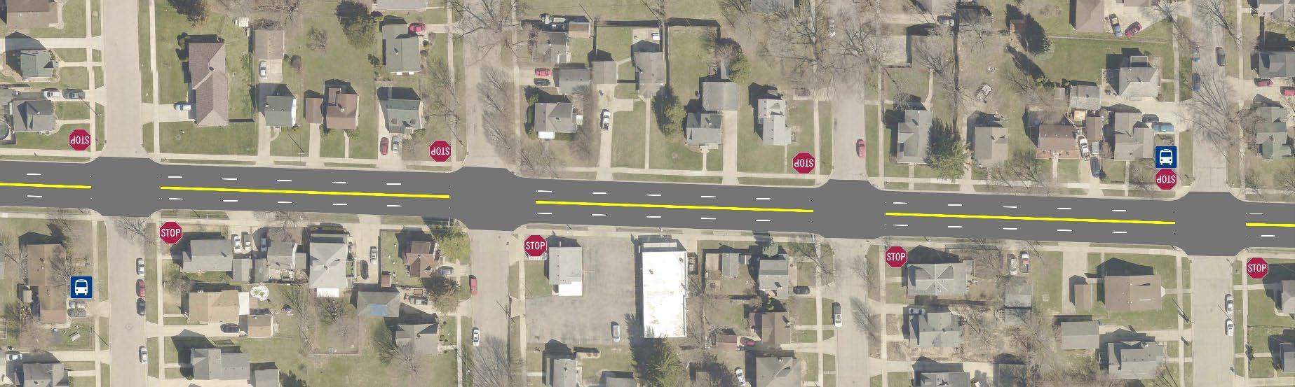
Sidewalks are present on both sides of East Memorial Drive. Not including the intersection with Milton Avenue, the only intersection with any crosswalk markings is with Harding Street. All other crosswalks are unmarked.
East Memorial Drive is not currently a marked bicycle route. Per the City’s current Janesville Area MPO Long Range Transportation Plan, this corridor is not planned to be an official bicycle route. Current observations indicate low usage of the corridor by bicyclists.
The Janesville Transit System (JTS) operates one bus route that travels through a portion of the corridor, Monday through Saturday. Stops are located on Cornelia Street and Prairie Avenue, near their respective intersections with East Memorial Drive, as shown in Figure 1-2
1.2.1
TRAFFIC VOLUMES
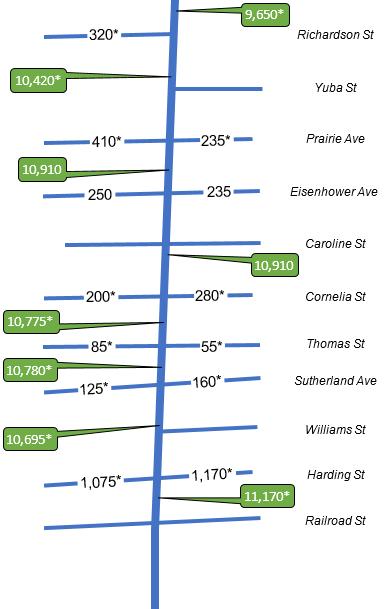
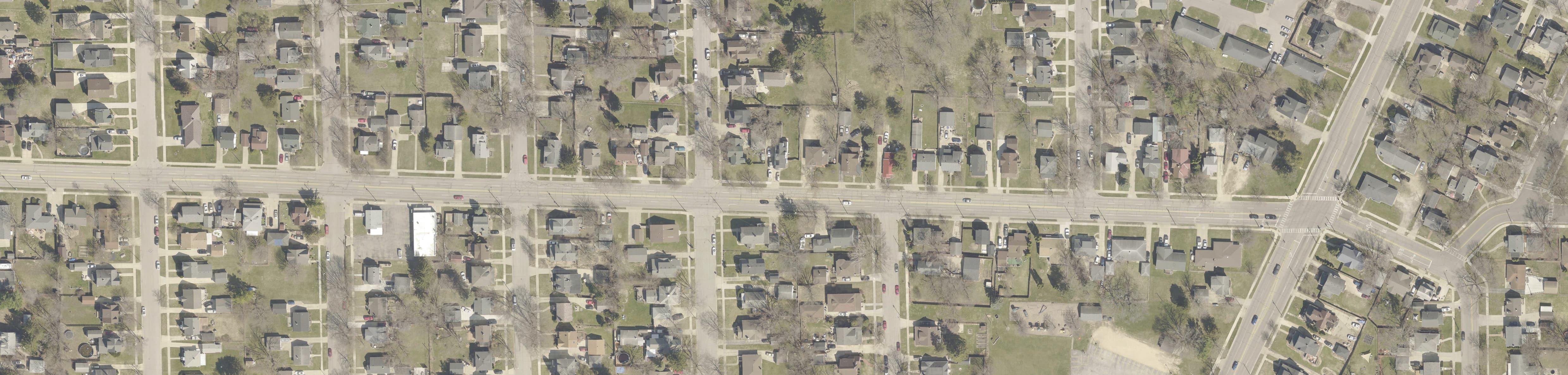
Turning movement and pedestrian crossing counts were collected at the study intersections in February 2023. Existing daily traffic along the corridor and selected side streets is shown in Figure 1-3. A full day (24 consecutive hours) of turn movement count data was collected at the intersection of East Memorial Drive and Eisenhower Avenue. An hourly profile of this data was created and reviewed to determine how much of the daily traffic occurred during the AM and PM peak hours. A peak hour adjustment factor was created for the AM and PM peak hours, then applied to the other six study intersections to approximate daily traffic for each of the roads.
Figure 1-2, JTS Bus Stop Locations
East Memorial Drive Corridor Study
Chapter 1 - Introduction & Background
City of Janesville, Rock County, Wisconsin October 2023
1-3, 2023 Daily Traffic Summary
A summary of the 2023 traffic data is included in Exhibit 1-1. Full count data is included in Appendix A.
As part of the traffic counts, non-motorized user volumes (pedestrians and bicyclists) were collected at the study intersections. Full count data is included in Appendix A.
1.2.1.1
Bicyclists
During the six hours of traffic data collected, no bicyclists were observed at any of the study intersections. Full count data is included in Appendix A.
The City collected additional bicyclist counts on May 17th & 18th, 2023 during the peak hours at the East Memorial Drive intersections with Cornelia Street and Prairie Avenue. A summary is provided in Table 1-1
Figure
East Memorial Drive Corridor Study
Chapter 1 - Introduction & Background
City of Janesville, Rock County, Wisconsin October 2023
Table 1-1, Summary of Observed Bicyclists on May 17th & 18th
Observations
Intersection
Prairie Avenue May 17th 1
Cornelia Street May 18th 2
• Crossing the south approach
4
• 1 crossing the north approach
• 1 crossing the south approach
Data from the May bicyclist counts is included in Appendix A.
1.2.1.2 Pedestrians
3
• 1 Crossing the north approach
• 2 crossing the south approach
• 1 crossing the west approach
• 1 crossing the north approach
• 2 crossing the west approach
Counts indicated low number of pedestrians crossed the study streets during the peak hours, typically four or less people. The intersection with the largest number of pedestrians crossing during any peak was at Cornelia Street, with four crossing the west approach (East Memorial Drive), during the PM peak period. The intersection at Prairie Avenue had the second-highest pedestrian volume, with three crossing the north approach (Prairie Avenue) during the PM peak. All other intersections had two or less pedestrians crossing during the peak hours.
The City collected additional pedestrian counts on May 17th & 18th, 2023 during the peak hours at the East Memorial Drive intersections with Cornelia Street and Prairie Avenue. A summary is provided in Table 1-2
Table 1-2, Summary of Observed Pedestrians on May 17th & 18th
Intersection
Prairie Avenue May 17th 1
Cornelia Street May 18th 0
• Crossing the south approach 2
3
• Crossing the south approach
• Crossing the south approach
Data from the May pedestrian counts is included in Appendix A.
1.2.2 CORRIDOR SPEEDS
As a spot check, travel speeds were recorded along a small portion of the study corridor between February 6th and 8th, 2023. The automated collection equipment used collects data in one direction
Project No. 00879099
7
East Memorial Drive Corridor Study
Chapter 1 - Introduction & Background
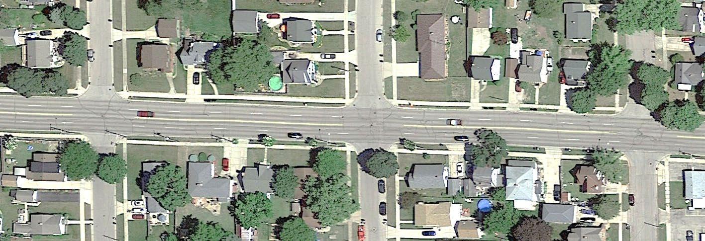
at a time for roadways more than two lanes wide. Eastbound data was collected on February 6th and westbound data was collected on February 8th Data collection points are shown in Figure 1-4; results are summarized in Table 1-3
1-4, Speed Data Collection Points
Table 1-3, Corridor Speed Summary
The posted speed in this portion of the corridor is 25 mph. The measured speeds correlate with complaints received regarding traffic traveling faster than desired through the corridor.
1.2.3 SAFETY ANALYSIS
1.2.3.1 Crash Data
A review of available reported crashes for the period of January 2018 through January 2023 was completed. Over that period, the study corridor experienced:
• 82 total crashes (this includes the North Parker Drive ramp terminal intersections; this does not include crashes that occurred at the Milton Avenue intersection)
• A corridor crash rate of 380** (the statewide average is 335 for a similar corridor)
• A corridor injury crash rate of 65** (the statewide average is 39 for a similar corridor) ** crashes per 100 million vehicle miles traveled
The majority of crashes within the study area were angle and rear-end type. The intersection with Harding Street had the highest number and rate of crashes within the corridor. One fatality occurred during the period, at the intersection with Prairie Avenue and involved a pedestrian. A summary including the number of crashes, severity, and crash type is included in Table 1-4. Additional crash data is provided in Appendix B.
City of Janesville, Rock County, Wisconsin October 2023 Project
Figure
East Memorial Drive Corridor Study Chapter 1 - Introduction & Background
City of Janesville, Rock County, Wisconsin October 2023
Table
1-4,
Summary of Intersection Crash Data
1.2.3.2 Crash Data Discussion
At the North Parker Drive ramp terminal intersections, a significant number of crashes were attributed to the merge from the off-ramp from North Parker Drive merging with westbound Memorial Drive. It was noted that many vehicles from the off-ramp were coming to a full stop when traffic from behind was not expecting that reaction. In the eastbound direction, a pattern was noted with traffic seeking to enter Kwik Trip crossing paths with traffic from the northbound North Parker Drive off-ramp.
Along the corridor, a significant pattern of traffic from the side street not seeing traffic traveling along East Memorial Drive. Often, traffic turning from East Memorial Drive hid traffic in the adjacent lane from the sight of traffic waiting on the side street. Several of these crashes were noted as also occurring at the driveway to Kwik Trip.
The fatality that occurred at the Prairie Avenue intersection could not be attributed to the roadway geometry or traffic control, based on information contained in the crash report.
East Memorial Drive Corridor Study
Chapter 1 - Introduction & Background
City of Janesville, Rock County, Wisconsin October 2023 Project
City staff has received concerns with the possible impact of trees and sightlines at the intersection with Harding Street. Of the 22 reported crashes at this intersection during the period, one crash report specifically referenced difficulty seeing through the trees in the northeast quadrant of the intersection. Four additional crashes could also be linked to visibility based on crash event descriptions. City staff and Operations staff have noted difficulties on the south leg of the Sutherland Avenue intersection due to the retaining wall as well.
Exhibit 1-1, 2023 Weekday Peak Hour Turning Movement Volumes
East Memorial Drive Corridor Study
Chapter 2 - Corridor Alternatives
City of Janesville, Rock County, Wisconsin October 2023
CHAPTER 2 – CORRIDOR ALTERNATIVES
This chapter explains the corridor cross section alternatives being considered for the study corridor. In all alternatives, parking is not permitted along East Memorial Drive for the entirety of the corridor.
Corridor concerns raised by city staff were taken into account when establishing viable alternatives. In addition to speed and crash history, staff wanted the corridor to be safer for pedestrians wishing to cross East Memorial Drive. With side street visibility, snowplow encroachment into the corridor travel lanes was also mentioned. At a few side streets, in order for a snowplow to gain adequate visibility of cross traffic, the front plow blade ends up in the through lanes of East Memorial Drive if the driver moves forward too far.
Conceptual layouts of the corridor alternatives are included in Exhibit 2-1 though Exhibit 2-3.
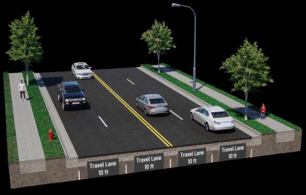
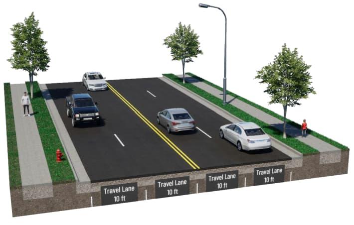
2.1 FOUR-LANE CORRIDOR
The existing East Memorial Drive corridor is four lanes wide, two eastbound and two westbound lanes. This is shown as corridor Alternative 1 in Figure 2-1. The existing lanes would be maintained; however, enhanced pavement markings and signage would be considered for crosswalk locations to reinforce the focus of pedestrian safety enhancement along the corridor
Alternative 1, 4-Lane Corridor
• Two, 10-foot wide travel lanes in each direction
2.2 T HREE-LANE CORRIDOR
Current traffic counts indicated that approximately 11,170 vehicles travel the study corridor in a 24-hour period. Projections indicate this will grow to approximately 12,800 vehicles per day by
Figure 2-1, Alternative 1: 4-Lane Corridor
East Memorial Drive Corridor Study
Chapter 2 - Corridor Alternatives
City of Janesville, Rock County, Wisconsin October 2023
2043. Wisconsin Department of Transportation (WisDOT) data suggests that a three-lane cross section is capable of handling up to 17,500 vehicles per day, substantially higher than projected 2043 volumes along the corridor.
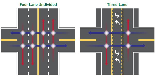
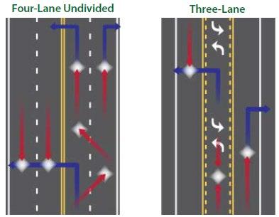
Utilizing minimum and typical lane widths as guides, three-lane alternatives were developed, which consist of variations of one eastbound and one westbound travel lane separated by a twoway left-turn lane (TWLTL).
A reduction in the number of lanes could:
• Reduce the incident of crashes by 19% to 47% (FHWA)
• Reduce the number of conflict points between vehicles, particularly weaving, as shown in Figure 2-2
• Add space for possible pedestrians and bicyclist enhancements
2-2, Conflict Point Comparison
Three variations of three-lane corridors were developed for comparison, as corridor Alternatives 2 through 4, as shown in Figure 2-3 through Figure 2-5
Source: FHWA
Figure
East Memorial Drive Corridor Study
Chapter 2 - Corridor Alternatives
City of Janesville, Rock County, Wisconsin October 2023
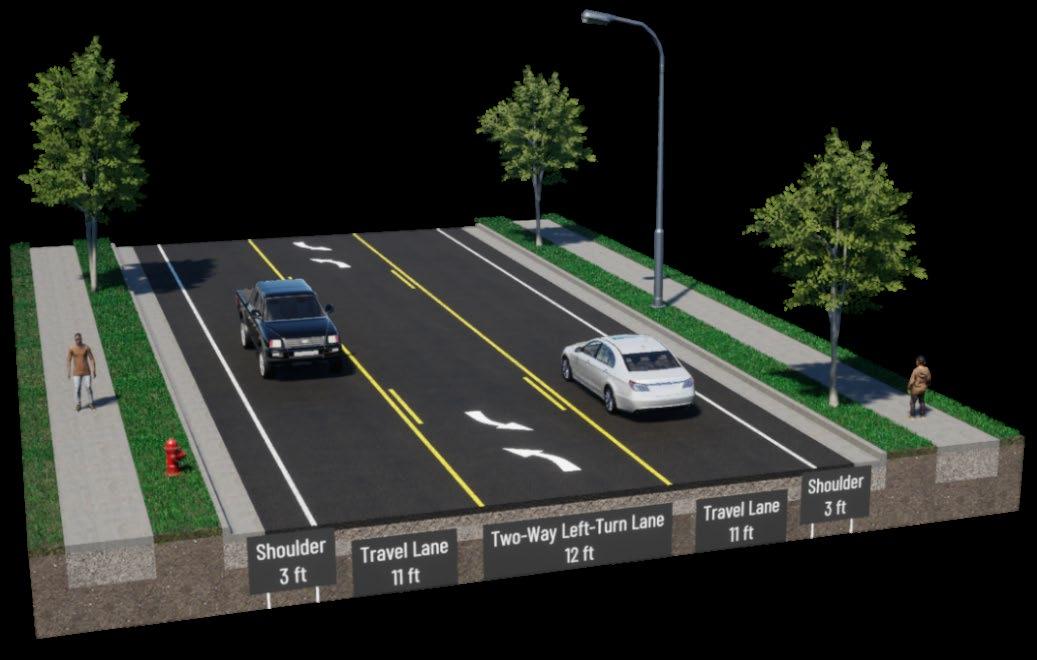
Alternative 2, 3-Lane Corridor with Narrow Shoulders
• A 3-foot wide shoulder along the outside edges of the roadway
• One, 11-foot wide travel lane in each direction
• One, 12-foot wide TWLTL separating the travel lanes
2-3, Alternative 2: 3-Lane Corridor, with Narrow Shoulders
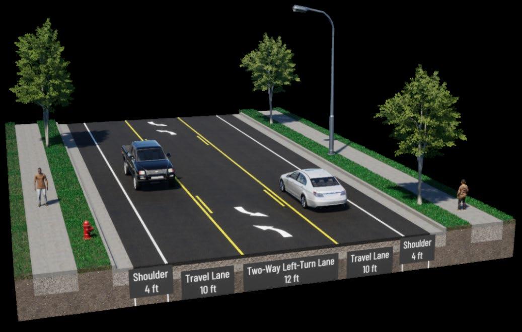
Alternative 3, 3-Lane Corridor with Wide Shoulders
• A 4-foot wide shoulder along the outside edges of the roadway
• One, 10-foot wide travel lane in each direction
• One, 12-foot wide TWLTL separating the travel lanes
2-4, Alternative 3: 3-Lane Corridor, with Wide Shoulders
Figure
Figure
East Memorial Drive Corridor Study
Chapter 2 - Corridor Alternatives
City of Janesville, Rock County, Wisconsin October 2023
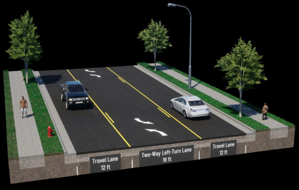
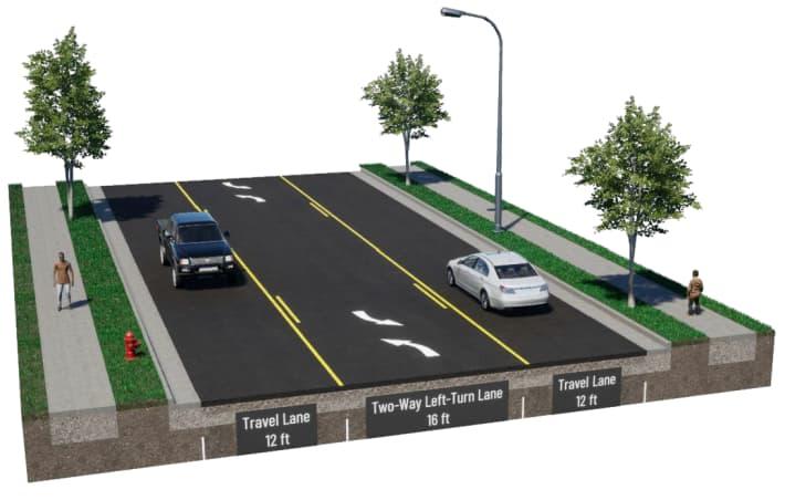
Alternative 4, 3-Lane Corridor with Wide Lanes
• One, 12-foot wide travel lane in each direction
• One, 16-foot wide TWLTL separating the travel lanes
2-5, Alternative 4: 3-Lane Corridor, with Wide Lanes
2.3 COMPARISON OF ALTERNATIVES
All corridor alternatives have advantages and disadvantages Table 2-1 provides a summary of how the corridor alternatives compare. Details regarding corridor operations are discussed further in Chapter 3.
Table 2-1, Corridor Alternative Comparison
Alternative Advantages
Disadvantages 1
4-Lanes
• User familiarity
• Allows for greatest amount of storage space during train events
• No change in corridor travel times
• Does not address speed or crash concerns
• Does not address speed differential or weaving concerns
• Does not improve safety for nonmotorized users
• Through traffic impacted by left and right turning vehicles
• Vehicles waiting to turn may hide vehicles in adjacent lanes from the sight of the side streets
• Does not allow space for snowplow equipment on side streets to wait without encroaching on E Memorial Dr traffic
• Ten-foot-wide lanes are narrow for bus and truck routes
Project No. 00879099
Figure
East Memorial Drive Corridor Study
Chapter 2 - Corridor Alternatives
City of Janesville, Rock County, Wisconsin October 2023
Alternative Advantages Disadvantages
2 3-Lanes Narrow Shoulders
• Removes left-turning traffic from through traffic
• Reduces speed differential
• Improves sight lines for nonmotorized users
• Potential to slow travel speeds
• Reduces the number of lanes for pedestrians to cross
• Accommodates improved visibility by introducing a buffer without encroaching into the travel lane
• Allows place for snowplow equipment on side streets to wait without encroaching on E Memorial Dr traffic
• Seasoned cyclists would likely be able to use the shoulder
• Less capacity for vehicle storage during train events
• Through traffic may encounter slight delays by right-turning vehicles
• Slight increase in corridor travel time
• Increases in delay for side street approaches
3 3-Lanes Wide Shoulders
• Removes left-turning traffic from through traffic
• Reduces speed differential
• Improves sight lines for nonmotorized users
• Greatest potential to slow travel speeds
• Reduces the number of lanes for pedestrians to cross
• Accommodates improved visibility by introducing a buffer without encroaching into the travel lane
• Allows place for snowplow equipment on side streets to wait without encroaching on E Memorial Dr traffic
• Seasoned cyclists would likely be able to use the shoulder
• Less capacity for vehicle storage during train events
• Through traffic may encounter slight delays by right-turning vehicles
• Slight increase in corridor travel time
• Increases in delay for side street approaches
• Ten-foot-wide lanes are narrow for bus and truck routes
East Memorial Drive Corridor Study
Chapter 2 - Corridor Alternatives
City of Janesville, Rock County, Wisconsin October 2023
Alternative Advantages Disadvantages 4 3-Lanes Wide lanes
• Removes left-turning traffic from through traffic
• Reduces speed differential
• Improves sight lines for nonmotorized users
• Reduces the number of lanes for pedestrians to cross
• Less capacity for vehicle storage during train events
• Wider travel lanes will not encourage slower speeds; speeds may increase
• Through traffic may encounter slight delays by right-turning vehicles
• Slight increase in corridor travel time
• Increases in delay for side street approaches
• Does not allow space for snowplow equipment on side streets to wait without encroaching on E Memorial Dr traffic
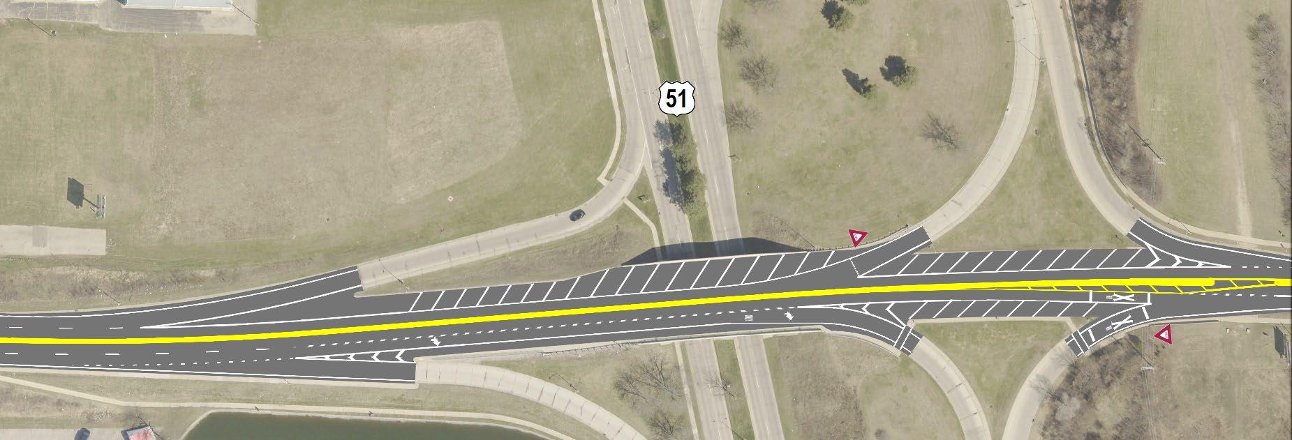
2.4 US 51 (NORTH PARKER DRIVE) RAMP T ERMINAL INTERSECTIONS
As discussed in Chapter 1, the ramp terminal intersections between North Parker Drive and East Memorial Drive have experienced a large number of crashes. While this portion of East Memorial Drive is just outside of the study corridor, lane reconfiguration ideas were drafted, as any change in lane configurations to the east would need to transition in this area. A draft reconfiguration option is shown in Figure 2-6
Highlights of this concept include:
1. Traffic from southbound North Parker Drive to westbound Memorial Drive merges into its own lane, eliminating merging conflicts between westbound traffic
2. Reducing the westbound direction to a single lane. This allows the merge from northbound North Parker Drive to westbound Memorial Drive to be aligned for better sightlines as well as reinforce proper yielding by off-ramp traffic.
3. Changing the outside eastbound lane into a turn-only lane to northbound North Parker Drive.
Figure 2-6, Preliminary North Parker Drive Ramp Terminal Lane Reconfiguration Concept
East Memorial Drive Corridor Study
Chapter 2 - Corridor Alternatives
City of Janesville, Rock County, Wisconsin October 2023
4. Realign the merge point to provide better sightlines.
A separate project covering this interchange is already in the works, which will further investigate operations and formalize reconfiguration options One such detail to be worked out is whether the off-ramp from northbound North Parker Drive should merge into its own lane instead of the offramp from southbound North Parker Drive (as currently shown).
2.5 FUNDING SOURCES
Municipal funding may be able to be offset by supplementary funding programs. A few of the funding sources are described below.
LRIP Local Roads Improvement Program
This funding assists local governments improve deteriorating city streets. This funding can reimburse up to 50% of eligible costs.
HSIP Highway Safety Improvement Program
This funding helps projects for sites which have a high crash history. Depending on the types of crashes encountered, up to 90% matching funds may be available to the community.
MSID Municipal Street Improvement Discretionary
This funding program targets high cost municipal street improvement projects that have a total project cost of $250,000. Funding tries to meet a 50%/50% cost split between state and local funding.
MSIS Municipal Street Improvement Supplemental
This funding program targets high cost municipal street improvement projects that have a total project cost of $250,000. The maximum funding split is 90% state with a 10% local match.
STP Surface Transportation Program – Urban
A federal funding allocation for eligible urban roadways with a classification of major collector or higher. Amounts vary based on anticipated program levels at the federal and state levels. The maximum funding split is 80% federal with a 20% local match, but may be as low as a 50/50 split
TAP Transportation Alternatives Program
As part of the Bipartisan Infrastructure Law, smaller scale projects for pedestrian or bicycle facilities may be eligible for up to 80% reimbursement of approved project costs.
Not all alternatives are eligible for every funding source. Table 2-2 provides a summary estimated alternative implementation costs as well as which funding sources may be applicable to the corridor alternative.
East Memorial Drive Corridor Study
Chapter 2 - Corridor Alternatives
City of Janesville, Rock County, Wisconsin October 2023
Table 2-2, Summary of Implementation Cost Estimates and Possible Funding Sources
1 4-Lanes 2 3-Lanes Narrow Shoulders 3
3-Lanes Wide Shoulders 4
3-Lanes Wide lanes
Exhibit 2-2,
Exhibit
Alternative with Wide Lanes
East Memorial Drive Corridor Study
Chapter 3 - Operational Analysis
City of Janesville, Rock County, Wisconsin October 2023
CHAPTER 3 – OPERATIONAL ANALYSIS
3.1 T RAFFIC FORECASTING
A review of growth rates for roadways near the study corridor as well as similar roadway types in Rock County was completed using available WisDOT and City data. Based on discussion with City staff, a growth rate of 0.75% was applied linearly to the collected turn movement count data in order to establish volumes for a 20-year horizon (2043). A summary of forecast data is included in Exhibit 3-1.
3.2 OPERATIONAL ANALYSIS RESULTS
An operational and capacity analysis was completed for the intersections using Synchro 11, utilizing Highway Capacity Manual (HCM) 6 th Edition methodologies. This type of analysis assigns a level of service (LOS) to each movement. LOS is a quantitative measure that refers to the overall quality of flow at an intersection ranging from very good, LOS “A,” to very poor, LOS “F”. The delay is measured in seconds per vehicle, which can be used to determine the level of service for the intersection. Table 3-1 represents the delay criteria used for determining the LOS at an intersection.
Table 3-1, Highway Capacity Manual Level of Service
3.2.1 INTERSECTION OPERATIONS
Analyses were completed for the existing four-lane corridor for both existing 2023 and forecasted 2043 volumes, as well as a three-lane corridor alternative. It should be noted that HCM procedures do not analyze operations of the TWLTL component of the roadway. Similarly, the change in lane width for the three-lane corridor alternatives results in a negligible change in expected operations. As a result, only one travel lane width was analyzed.
Full operational analysis results are included in Exhibit 3-2 through Exhibit 3-9 A summary of key intersection operations is included in Table 3-2 All movements along East Memorial Drive are expected to have less than 10-seconds of delay (LOS A)
East Memorial Drive Corridor Study
Chapter 3 - Operational Analysis
City of Janesville, Rock County, Wisconsin October 2023
Table 3-2, Summary of Intersection Operations
Corridor Condition Analysis Year
2023
4-Lane (existing)
2043
2023
3-Lane
3.2.2
2043
Summary of Operations
• Side street approaches are expected to have approximately 12 s –23 s of delay, (LOS B – C)
• Largest delays occur on the side street approaches at the Harding St and Prairie St intersections
o Harding St: approximately 23 s, LOS C (PM peak)
o Prairie St: approximately 21 s, LOS C (AM peak)
• Side street approaches are expected to have approximately 13 s –32 s of delay, (LOS B – D)
• Largest delays occur on the side street approaches at the Harding St and Prairie St intersections
o Harding St: approximately 32 s, LOS D (PM peak)
o Prairie St: approximately 25 s, LOS C (AM peak)
• All other side streets do not exceed approximately 22 s of delay, (LOS C)
• Side street approaches are expected to have approximately 14 s –28 s of delay, (LOS B – D)
• Largest delays occur on the side street approaches at the Harding St and Prairie St intersections
o Harding St: approximately 28 s, LOS D (PM peak)
o Prairie St: approximately 26 s, LOS D (AM peak)
• All other side streets do not exceed approximately 22 s of delay, (LOS C)
• Side street approaches are expected to have approximately 15 s –44 s of delay, (LOS B – E)
• Largest delays occur on the side street approaches at the Harding St and Prairie St intersections
o Harding St: approximately 44 s, LOS E (PM peak)
o Prairie St: approximately 33 s, LOS D (AM peak)
• All other side streets do not exceed approximately 25 s of delay, (LOS C)
CORRIDOR OPERATIONS
Corridor operations was completed using SimTraffic 11, utilizing WisDOT calibrations 1. This type of analysis uses microsimulation to animate the traffic volumes, and base their motions on assigned speed limits, lane assignments, and traffic controls. Corridor operations are assessed based on the travel time from end to end (seconds) and the resultant average speed (mph) for each direction. Results from this analysis is shown in Table 3-3 through Table 3-5.
1 From the WisDOT Traffic Engineering, Operations, and Safety Manual (TEOpS) 6.2.1, Table 6.1, accessed April 2023
East Memorial Drive Corridor Study Chapter 3 - Operational Analysis
City of Janesville, Rock County, Wisconsin October 2023
Table 3-3, Eastbound Corridor Operations
Table 3-4, Westbound Corridor Operations
Table 3-5, Corridor Operations, Alternative Comparison, 3-Lane versus 4-Lane
3.3 OPERATIONAL ANALYSIS DISCUSSION
Results of the operational analyses of the study intersections and overall corridor reveal expected increases in delay for the side streets as well as increased overall corridor travel time. Despite the increases in delay, operations are expected to remain at acceptable levels for a corridor of this type. Increased delays are common when side streets intersect arterial roadways similar to East Memorial Drive.
Side street queues are expected to remain at two vehicles or fewer during the majority of peak periods. Due to natural fluctuations and unforeseen events (e.g., crashes, traffic enforcement, weather, etc.), longer queues may occur on an infrequent basis.
Observation of current traffic flows along East Memorial Drive revealed few vehicles are willing to drive side-by-side in the existing four-lane configuration. This is likely the result of the current narrow lanes. Because of this, the size of gaps in platoons of traffic is not expected to change much if the cross-section is reduced to a single lane in both directions.
3.4 RAILROAD CROSSING EVENTS
Based on Federal Railroad Administration (FRA) data, one train typically traverses the railroad crossing with East Memorial Drive on the east end of the study corridor between 6:00 AM and 6:00 PM. These trains typically operate through the crossing between five and ten mph. Based on the noted train speeds, observed train length, required railroad crossing signal activation times
East Memorial Drive Corridor Study
Chapter 3 - Operational Analysis
City of Janesville, Rock County, Wisconsin October 2023
(per the Manual on Uniform Traffic Control Devices (MUTCD)), and Wisconsin state law2, a range of times were calculated that a train crossing event would block traffic along East Memorial Drive: four-minutes (minimum), ten-minutes (maximum). One train crossing event (blockage of East Memorial Drive) was simulated during each of the peak hours (AM and PM). Results from this analysis is shown in Table 3-6 through Table 3-8
Table 3-6, Eastbound 95th Percentile Queue, ft
Table 3-7, Westbound 95th Percentile Queue, ft
Table 3-8, 95th Percentile Queues, Alternative Comparison, 3-Lane versus 4-Lane, ft
Note that the above results are intended as simulations only and every real train event is different in terms of speed, length, and the resulting time East Memorial Drive is blocked. The simulation is intended to cover the typical range of trains and it is not possible to cover every possible scenario, including but not limited to crashes and mechanical breakdowns which could result in East Memorial Drive being blocked for longer periods of time.
For reference, Table 3-9 lists the approximate amount of space available for queuing between the railroad crossing (stop bar location) and the respective cross street intersections along the corridor. Note that Washington Street and the US 51 ramps are west of the study corridor and are included for general reference purposes only.
2 Wisconsin law states that a train cannot block a railroad crossing for longer than ten minutes, except in the event of a crash, Wisconsin Office of the Commissioner of Railroads, 2015, Wisconsin Railroad Enforcement Guide, accessed April 2023, https://ocr.wi.gov/Documents/WisconsinRailroadEnforcementGuide(2015).pdf.
East Memorial Drive Corridor Study
Chapter 3 - Operational Analysis
City of Janesville, Rock County, Wisconsin October 2023
Table 3-9, Corridor Side Road Distances
Available Distance from Railroad Crossing To ft
51 NB On-Ramp* 485
* located west of study corridor limits
Reducing East Memorial Drive to a single lane in both directions would likely result in approximately 775-feet of additional queue length during the typical train crossing event by 2043.This means that instead of westbound queues impacting Williams Street, they would likely now impact Cornelia Street as well.
Exhibit 3-1, 2043 Weekday Peak Hour Turning Movement Volumes, Forecasted Period Operations, 3-Lane Alternative
Exhibit 3-2, 2023 Weekday Peak Period Operations, 4-Lane Alternative
Exhibit 3-3, 2023 Traffic Capacity/LOS Analysis
Existing Transportation System
Exhibit 3-3, 2023 Traffic Capacity/LOS Analysis
Existing Transportation System
Exhibit 3-3, 2023 Traffic Capacity/LOS Analysis
Existing Transportation System
Approach with Stop control
- Operations not calculated for movements with no vehicular conflict
95th percentile queues reported
Queues rounded to the
Exhibit 3-4, 2023 Weekday Peak Period Operations, 3-Lane Alternative
Exhibit 3-5, 2023 Traffic Capacity/LOS Analysis
Improved Transportation System
Queues
Exhibit 3-5, 2023 Traffic Capacity/LOS Analysis
Improved Transportation System
Exhibit 3-5, 2023 Traffic Capacity/LOS Analysis
Approach with Stop control
- Operations not calculated for movements with no vehicular conflict
Red indicates altered/improved condition from previous state
95th percentile queues reported
Queues
Exhibit 3-6, 2043 Weekday Peak Period Operations, 4-Lane Alternative
Exhibit 3-7, 2043 Traffic Capacity/LOS Analysis
Existing Transportation System
Exhibit 3-7, 2043 Traffic Capacity/LOS Analysis
Existing Transportation System
Exhibit 3-7,
Approach with Stop control - Operations not calculated for movements with no vehicular conflict 95th percentile queues reported Queues rounded to the
Exhibit 3-8, 2043 Weekday Peak Period Operations, 3-Lane Alternative
Exhbit 3-9, 2043
Improved Transportation System
Improved Transportation System
Approach with Stop control - Operations not calculated for movements with no vehicular conflict 95th percentile queues reported
Queues
East Memorial Drive Corridor Study
Chapter 4 - Public Input City of Janesville, Rock County, Wisconsin October 2023
CHAPTER 4 – PUBLIC INPUT
A Community Engagement Forum (CEF) was held on May 10th, 2023, at Adams Elementary School. City staff, assisted by MSA staff, presented the current and projected traffic volumes and operations, crash data, as well as potential corridor improvement alternatives. The goal of the CEF was to get community input on areas of particular concern for pedestrians and bicyclists, as well as opinions on which corridor alternative they preferred. Additional exhibits provided at the CEF are included in Appendix C.
Following the CEF, materials presented were also uploaded to the city’s website to gain additional comments. Comments from both campaigns were received from ten individuals. A summary of comments received is included below:
• Six individuals were in support of reducing the corridor to three lanes; two were against changes, and the remaining two did not specifically take a stance one way or the other
• Those in support
o Were happy something is being proposed, as speeding is a problem
o Felt the lane reduction would help visibility from the side streets
o Wanted bike accommodations included in some form (e.g., bike lane, off-street path)
• Those against
o Did not think the changes will help and the cost would be prohibitive to taxpayers
o Did not think the TWLTL will accommodate the amount of traffic
o Did not think issues were being adequately addressed near Kwik Trip
• Other thoughts submitted included
o Concerns as to impacts to parallel routes and the surrounding neighborhood if East Memorial Drive is reconfigured into two lanes
o Wanted additional pedestrian crossing enhancements (e.g., refuge island, rectangular rapid flashing beacons (RRFB), enhanced crosswalk markings)
o CEF attendees indicated the Cornelia Street and Prairie Avenue intersections with East Memorial Drive as areas of specific concern for pedestrians (bus stops are located adjacent to both intersections)
As a follow-up to the received comments, additional pedestrian counts were completed at the Cornelia Street and Prairie Avenue intersection locations on May 17th & 18th, 2023. The latest counts did not show significantly higher pedestrian volumes than those collected in February.
East Memorial Drive Corridor Study
Chapter 5 - Recommendations & Next Steps
City of Janesville, Rock County, Wisconsin October 2023
CHAPTER 5 – RECOMMENDATIONS & NEXT STEPS
5.1 RECOMMENDATIONS
Based on acceptable operations and the safety benefits, it is recommended to modify East Memorial Drive into a three-lane corridor. The additional delay induced by the change is still within acceptable industry benchmarks during the peak travel periods. To mitigate additional delay at Harding Street, creating an exclusive right-turn only lane and shared left-turn/through movement lane combination could be considered. Train crossing events will have an effect on queues; however, should be infrequent, based on current track usage.
The change is expected to reduce crashes by moving slowing/stopped turning traffic for side streets and driveways out of the faster through traffic along the corridor. This will reduce weaving as well as reduce the potential for vehicles to be hidden from sight from the side streets. Having only one eastbound and one westbound through lane will increase pedestrian safety by reducing the number of active travel lanes they need to cross.
5.1.1 3-LANE CORRIDOR ALTERNATIVES
As shown in Chapter 2, three alternatives were identified for a 3-lane corridor configuration, as summarized in Table 5-1
Table 5-1, Summary of 3-Lane Corridor Alternatives
Per WisDOT design recommendations, a TWLTL is typically 14-feet wide, with 16-feet as a maximum and 12-feet as a minimum.
Alternative 4 with wide lanes was eliminated from recommendation, as the wider travel lanes will not encourage slower travel speeds and may actually result in motorists feeling more comfortable traveling faster than they do with the current two adjacent 10-foot wide (20-foot total) lanes. Based on maintenance feedback, the lack of a shoulder Alternative 4 would not allow snowplows to creep forward from side streets to improve visibility without the equipment encroaching on the through-lane of East Memorial Drive.
Table 5-2 compares the features of the alternatives to the relative impact to various user groups of the corridor, using a ranking of zero to five stars (zero = worst, five = best).
County, Wisconsin October 2023
Table 5-2, Comparison of Alternatives 2 and 3
The recommendation is to proceed with Alternative 3 (Wide Shoulders) Vehicle speed is a significant concern along the corridor. Wider travel lanes feel more comfortable to general motorists and result in higher average speeds. The narrower 10-foot travel lanes with Alternative 3 is expected to have the greatest impact on speed reduction, while providing space on the outsides that could be used by bicyclists
While the corridor is not currently a bicycle route, nor is planned to be a marked route, a few comments indicated support or desire for bicycle accommodations to be included. If a bicycle lane is desired, the preferred bicycle lane width is 5-feet, adjacent to a curb A width of 4-feet is an allowable minimum, but due to high traffic volumes, the lane will feel uncomfortable for all but experienced bicyclists. Either alternative provides space that could be used by those who feel comfortable riding with higher volumes of traffic. Both alternatives fall short of the desired width, but Alternative 3 does meet the allowable minimum width.
Both alternatives allow space for snowplow equipment to encroach from the side streets without impacting traffic along East Memorial Drive.
Since East Memorial Drive is both a bus and a truck route, accommodations for wider vehicles can be a concern. The existing lanes are 10-feet wide currently. As the volume of left turning vehicles is low for most of the intersections along the corridor, larger vehicles could safely temporarily encroach on the TWLTL should extra passing space on the right be necessary. Given the current mix of traffic along the corridor, the frequency of these occurrences is expected to be low
5.1.2 PEDESTRIAN IMPROVEMENTS
Based on feedback received from the public and review of the study corridor, marked crosswalks should also be provided for pedestrians crossing East Memorial Drive at Cornelia Street and at Prairie Avenue, in addition to maintaining the existing marked crosswalk treatments at Harding Street. This aligns with pedestrian traffic associated with the adjacent bus stops. Current pedestrian volumes do not suggest RRFBs or median refuge islands are necessary or meet WisDOT warrants, but could be considered if additional safety issues arise in the future.
5.2 NEXT STEPS
If the corridor is modified to a 3-lane cross section, how the section ties into the North Parker Drive ramp terminal intersections and the Milton Avenue intersection will need to be further investigated. Concepts included in the CEF materials (Appendix C) include tie-ins to both, but are not based on formal traffic volume/operational studies. The tie-in to the Milton Avenue intersection approach maintains the existing lane configuration and turn lane storage size. Operational analysis would need to be completed for this intersection to determine if the lane sizes and assignments and traffic signal phasing is still appropriate.
City of Janesville, Rock County, Wisconsin October 2023
Coordination with the North Parker Drive ramp project would need to occur to determine how best to modify the East Memorial Drive cross section within the interchange area, while improving the safety of merging traffic from the off-ramps and the adjacent intersections.
How best to handle side-street intersections will need to be further investigated Preliminary concepts included in Appendix C show turn lanes included near Harding Street, due to the higher number of left turns (relative to the other study corridor intersections). Final determination of which intersections receive dedicated left-turn lanes versus a continuation of the TWLTL will need to occur. Similarly, pedestrian safety enhancement locations will also need to be finalized as well Depending on the magnitude of improvements, additional funding can then be sought from the options listed in Table 2-2.