6 minute read
2.1. Identity of a Place

from Master thesis in Regeneration of Heritage Coastal Sites. Al Max, Alexandria, Egypt.
by Nancy Morsy

The natural, geographical, cultural and social life norms of a city are the aspects of it’s identity from architectural and urban points. It’s urban images in an urban space are formed by aspects through long periods. Nowadays uban spaces are facing the problem of losing their poriginal identities through changing it’s urban image by inventing new architectural and urban formation process. Regularly regenerating cities lose their citizens live perception and memory making them lose their sense of belonging by losing the original image they formed from it’s historical and cultural heritage. By then, social and cultural norms will change leaving a new perception for the city losing it’s original identity. In urban planning and landscape, the place identity is linked to the interaction between it’s physical features and users. The unique characteristics of a place is what make it distinctive, a place can ary in size from a room to a nation. There are three aspects for characterising a place, these are forms considering topography, buildings, spaces and things which are the base foundation of the place regardless the existence of it’s society; activities including the ecological processes, land uses, traffic movement and people; meanings and they can be aesthetic, political, ethicalm cultural or spiritual values associated with places forming memories, traditioins, histories, symbols, perceptions and future plans. [Ginting, N.; Wahid, J.; 2017]
History subsists so long as an object is in use, in other words, as long as a guise relates to its unique function. Nonetheless history transforms into a realm of memory when the function is discerped and only the guise remains. By then, history ends and memory begins. For instance, the soul of a city turns into its history while its distinguishing and classical character turns into its memory. Thus, one can assume that a city could be defined based on the collective memories of its people, joined with objects and places. Consequently, the locus of the collective memory is the city, where locus is defined as the relationship between a specific location and buildings that are found in that location. Therefore, the current time of architecture is characteristic to memory, in attempts to substitute history. Introducing memory into the object it becomes the embodiment of both a creative idea of itself and a memory of its former self. Hence, the actual transformation of the space is based on the participation of the collective memory and the guiding theme of the entire complex urban structure is the memory. So, memory serves as a tool of imagination and reconstruction of the future time of fantasy that comes to realization of the analogous-concept of a city. Inspired from Aldo Rossi’s “The Architecture of the City” [Rossi,1966]
Advertisement
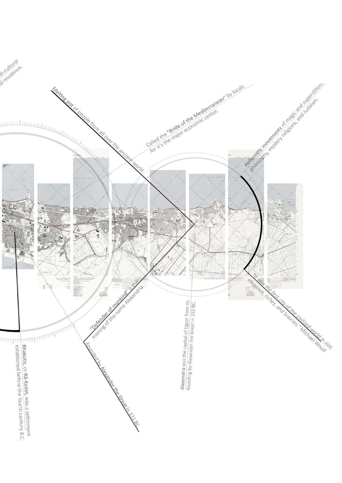
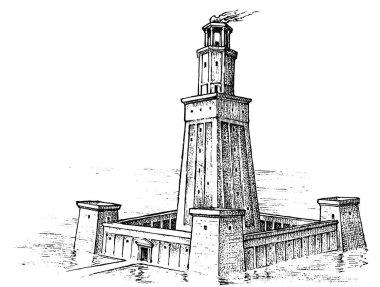
Alexandria is an ancient city on the Mediterranean. The city has a tremendous impact on the history of the Mediterranean. The Pharos, a
legendary lighthouse that was once regarded one of the ancient world's
seven wonders, is also located in Alexandria. On the little Pharos Island, the lighthouse remained for approximately 13 centuries. Even if the Pharos was slain, its legend and legends continue on. Pharology, the discipline of building lighthouses, was inspired by the Pharos. The enormous lighthouse at Alexandria drew tourists, historians, and others. Even now, its reputation and popularity outnumber those of Alexandria's other luminaries. [Lighthouses of Alexandria; Wikipedia]
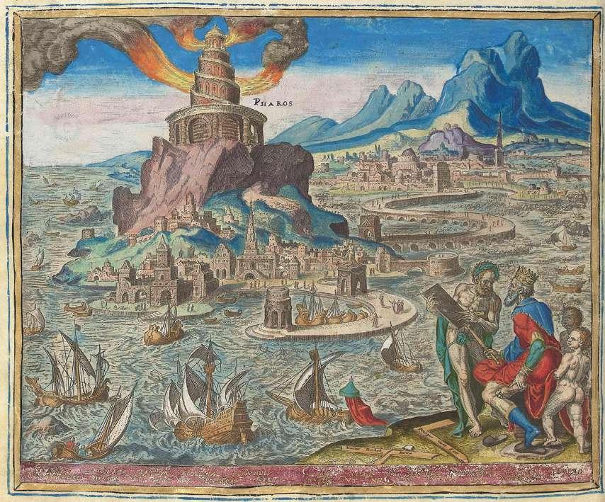
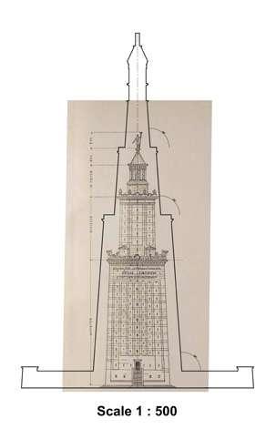
Figure 10: Lighthouse of Alexandria by Philip Galle; 1572, Rijksmuseum. / Source: Wikipedia
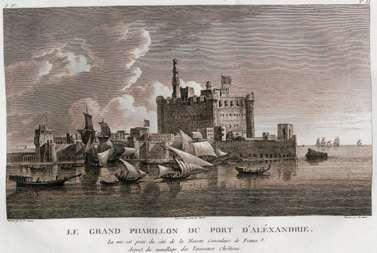
The renown and legacy of Alexandria's famous Pharos have cast a pall over the city's other lighthouses. Lighthouses are an endangered architectural type that may soon become obsolete due to advances in navigation technology. Because lighthouses are always built in places with the hardest weather, they are more prone to deterioration and degradation. In Alexandria, there are still six lighthouses. Except for the Montazah lighthouse, which is located in the Montazah Palace grounds to the east of the city, they are mostly located in the western portion of the city. Some of the lighthouses are inoperable, while others are inaccessible. Figure 1 depicts modern Alexandria and the locations of extant lighthouses in the city's western section. [Manzoni, S.; El,
R.; Lighthouse, T.; Aaha, C.; 63, N.; Aref, Y. G., 2010]
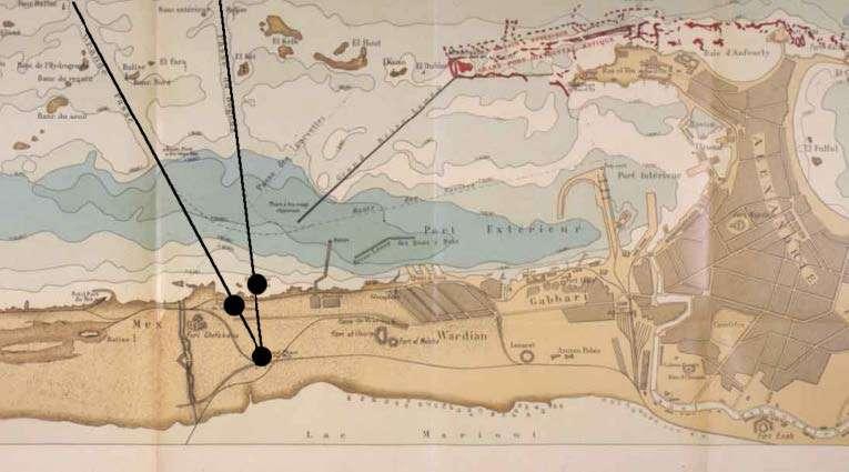
Figure 11: Map of Alexandria 1912 illustrating the relationship of Al Max lighthouses with other lights. The lines mark the safe passage in and out of the harbor avoiding rocks and other obstacles. / Source: base map after Jondet.

Figure 13: Map of Pharos Island and the Eastern Harbor. (Forster, 1961). / Souce: Wikipedia
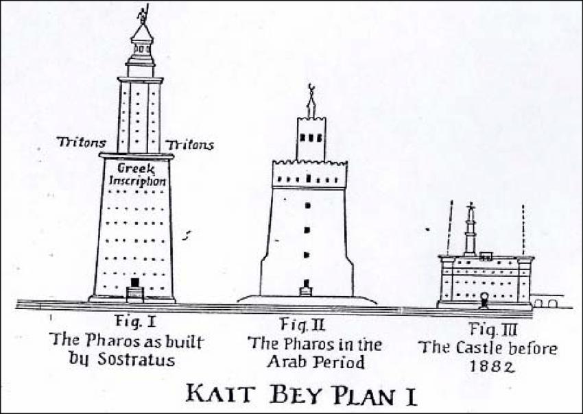
Figure 12: Different stages of destruction of Alexandria Lighthouse (Thiersch, 1909)/ Image credit: Wikipedia
Fig I
280 BC
Figure 14: Hand sketch illustrating the Pharos lighthouse built by the Greek. / Image credit: Arthur Balitskiy. The Lighthouse of Alexandria stood for over 1,500 years, even withstanding a severe tsunami in 365 AD.
Fig II
The earthquake tremors likely caused the cracks that appeared in the structure by the end of the 10th century. This required a restoration that lowered the building by around 70 feet.
10th century
Fig III
14th century
Figure 15: The citadel of Qaitbay in the 1780s, by Louis-François Cassas. / Image credit: Wikipedia Figure 16: A size comparison between a 1909 (inner shape) and a 2006 study (outer shape) of the building. / Source: Wikipedia
Then came Sultan Qayetbay and fortified the place as a part of his coastal defenses and built on its site his castle from the existing ruins.
Figure 19: Southern view of Ras El Tin Lighthouse. / Source: The Alexandria & Mediterranean Research Center
Ras Al Tin Lighthouse
Figure 17: Deteriorated condition of Mex Old Lighthouse and its section respectively. / source: Alexandria & Mediterranean Research Center
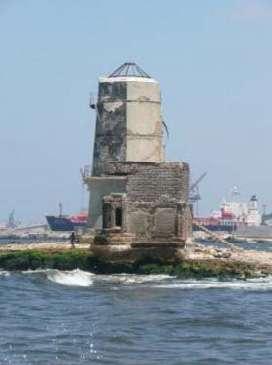
1873 Al Max Old Lighthouse
1890
1848 Al Agami Lighthouse
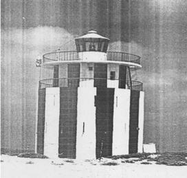
Figure 18: The Agami unmanned lighthouse/or beacon / Source: Egyptian Authority for Maritime Safety
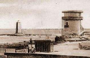
Figure 20: Views of the Low Mex Lighthouses showing their setting and alignment / Source: The Alexandria & Mediterranean Research Center
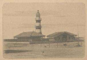
1894 Al Max Low Lighthouse
Al Max High Lighthouse
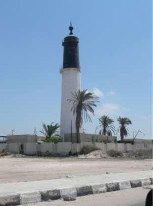
Figure 21: Northern view and section of the Mex High Lighthouse respectively. / Image credit: Yasser Aref 1908 1940
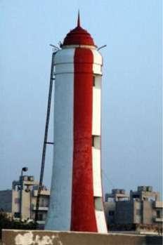
Al Montazah Palace Lighthouse
Figure 22: Northern view and section of the Mex High Lighthouse respectively. / Image credit: Yasser Aref
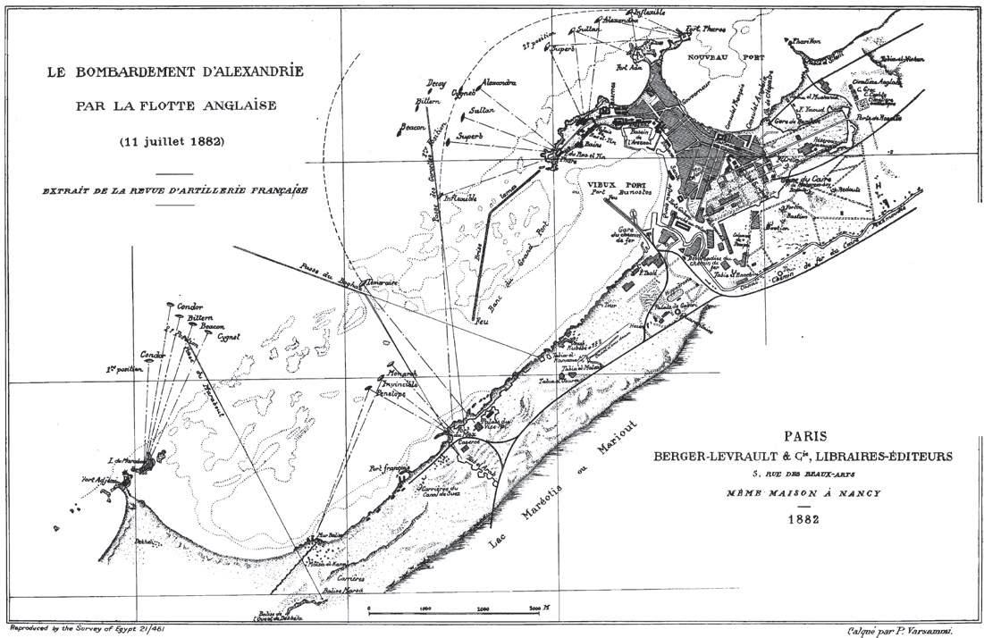
Figure 23: Historical Map of Alexandria, Egypt, from 1882. / Image Credit: The survey of Egypt.
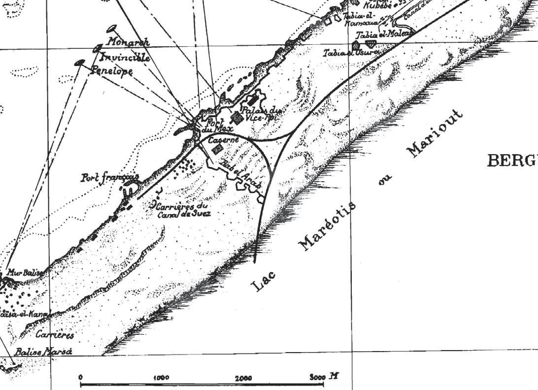
Figure 24: Blow up to Al-Max village from the historical Map of Alexandria, Egypt, from 1882. / Image Credit: Author