CONTENTS
Preface 8
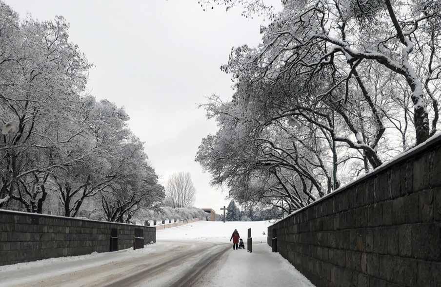
1. Reforming Terrain 10
Marc Treib
2. Repton for Real: The Practical and Pictorial 32
Stephen Daniels
3. The Art of Landmaking 50
Adr iaan Geuze
4. The Starting Ground 70
Bas Smets
5. Scaled Down 92
Jennifer Guthrie
6. Unleveling the Land, On Sand and Lava 108
Karl Kullmann
7. Ten Topographic Acts 126
Marc Treib
8. Moving the Earth, Stirring the Soul 148
David Meyer
9. Trash Topography: Shaping Postindustrial Land 168
Elissa Rosenberg
10. Topography as Expressive Form 188
<
Ana Kucan
11. The Washington Monument
Topographically Considered 208
Kathleen John-Alder
12. To Act or Not to Act 228
Georges Descombes
13. Renewal and Topophilia: Toronto’s Port Lands 246
Laura Solano
14. Contours With and Without Lines 266
José Miguel Lameiras
Acknowledgments 280
Contributors 282
Index 285
PREFACE
Winston Churchill famously observed, “we shape our buildings; thereafter buildings shape us.” With only slight modification, that pronouncement could apply equally to the influence of topography as the foundation for all landscape architecture. We shape the land; thereafter, it shapes how we live upon it. Transforming the earth is the primary act in realizing any landscape design— whether an act minimal or momentous, whether applied to unspoiled natural terrain or a polluted brownfield. It provides the base and basis for all subsequent planting and paving; it is the ground from which all buildings rise. Most commonly, the acts of digging, piling, and reshaping first address issues of function and performance. At other moments, however, the earth is altered for purely aesthetic reasons, at an extreme making sculpture of the land. In real estate, it is said that the three most important factors are “location, location, location.” That adage applies in equal measure to the reconfiguring of the earth, as on location depend soil composition, its stability and fertility, and the vegetation that thrives there.
Held at the University of California, Berkeley, in March 2020, the symposium The Shape of the Land: Aesthetics and Utility gathered a select group of twelve landscape architects and historians hailing from eight countries, who presented their thoughts on the place of topography in their own work and in the works of others, both contemporary and historical. The range of scales represented by these projects was staggering, spanning the intimacy of backyard gardens to the grandeur of major infrastructure—here represented by the reworkings of the Don River in Toronto and the River Aire outside Geneva. One might humorously suggest that as an opening foray exploring the subject of topography, this book can only “scratch the surface.” It is intended to question, inform, and provoke rather than provide an exhaustive study. Together, the chapters confirm topography’s elemental and exquisite significance, whether in the design of an urban fountain or a “renaturalized” river.
The subtitle of the symposium, Aesthetics and Utility, emphasized the importance of the actual terrain, its forms, spaces, and materials— and that aesthetic concerns remain crucial, even in designs focused on social and/ or environmental issues. Intended or not, all modifications to topography have an aesthetic consequence, a consequence that should be considered in the design. This is true even for landscapes we judge unsightly or blatantly deleterious, such as the toxic tailings of mineral extraction. Making form always has consequences.
8
Fewer than half the talks at the symposium originated as complete texts, which made producing chapters from the presentations a considerable challenge. For those talks without texts, the videos of the presentations were transcribed and substantially rewritten. For others, the original texts were heavily reworked, augmented by missing information and transitions, and in some cases even introducing issues I felt necessary to render the essay more focused or comprehensive. The speakers/authors then reviewed the suggested revisions of their talks, commenting and correcting as needed. The final form of the chapters represents a version mutually agreed upon as final. The book’s fourteen commentaries reflect particular and personal points of view as well as the broader factors, constraints, and ideas that bear on their authors’ own work. As no attempt was made to impose any standard template on all the texts, considerable variety is evident in the approaches and structures of the essays. Despite the differences in discourse and terminology, each of the authors has positioned an aesthetic regard for topographic design within a greater social and environmental context. I would offer that most of the projects, despite their focus on ground form, are ecologically based and socially aware—and beautiful, if in varying ways. All began with topography, a consideration of the ground itself, the shape of the land.
Marc Treib Berkeley, December 2021
9
REFORMING TERRAIN 1.
10
1-1
MARC TREIB
[Marc Treib]
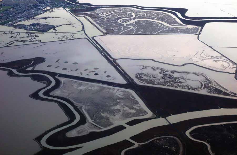
In Genesis it is written, “Let the waters under the sky be gathered into one place, so that the dry land may appear. . . . And it was so” [1-1].1 Although water is said to still occupy two-thirds of our planet’s surface, we live primarily on the land, on terra firma. In making landscape architecture, this land—topography—is primary in all but the most unusual of commissions. Earth is the surface upon which we work, and earth is the material with which we begin our designs. As soil, it provides the nutrients necessary for vegetal life. As a medium for landscape design, it is shaped, excavated, piled, and graded into varied levels and specific forms. Cutting and filling are primary acts in making almost every landscape. Although perhaps instigated by pragmatic concerns, grading inherently constitutes a sculptural act enfolding both need and expression. Today’s landscape architect emulates what in the Beginning represented only divine intervention. As proclaimed in George Frideric Handel’s Messiah, modeling the land was part of the Creation: “Every valley shall be exalted: Every mountain and hill made low, the crooked straight, the rough places plain.” If not quite to the same extent, the landscape architect also intervenes by reshaping the land, according to a plan.2 At times humans do play God and make their own land, however; Venice and much of the Netherlands provide excellent examples of this form of creation. When asked what plans had been made for the architecture and landscape of the recently constructed Ijmeer housing development in Amsterdam, Dirk Sijmons responded: “We don’t have any specific plans as yet; we have to finish designing the land first.”3 A related story involves Máxima, or Leidsche Rijn Park designed by West 8, also in the Netherlands, whose construction began in 1997. On a bicycle tour on the park’s loop path when construction was still underway, West 8 principal Adriaan Geuze pointed to the sand and earth piled where the then-dammed river would eventually flow and told me: “The Rhine will be over there, but we haven’t finished making it yet” [1-2].4 Or consider the seemingly natural landscape of New York’s Central Park that in actuality demanded the complex conversion of diverse terrains to shape a landscape to
Salt evaporation ponds. San Francisco Bay, California.
11
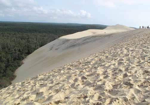
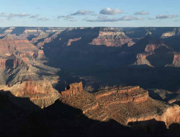
accommodate social use, traffic, address environmental demands, and provide water storage. The Olmsted-Vaux design for the park bundled all those needs within a landscape that appears to have survived from some primordial era, long before Manhattan was settled by Europeans. Not so, not at all. From these historical references and contemporary anecdotes we understand that land can be made as well as remade, and that the form of that land is consequential. While we of ten consider land a static entity, it is in fact an active material continually reshaped by environmental forces and human efforts. Sand dunes, whether those of the great African deserts or the anomalous Grand Dune du Pilat in southwestern France, are always on the move [1-3]. Mountains erode; their sediment and debris fill estuaries and rivers or are carried to the sea. Displaced by glaciers, uncounted tons of rock, soil, and rubble may travel hundreds, even thousands of miles. Ultimately, then, we recognize that land is created through explosion, erosion, and sedimentation, by building up and wearing down, by inorganic and organic processes and through human intervention. The Grand Canyon in Arizona may be America’s most dramatic exemplar of erosion, but it has resulted from forces and processes that act upon all land, although their resulting forms are rarely so spectacular [1-4].
Animate yet nonhuman activities also remake the land. Animals dig holes to bury food, others make burrows for habitat, or some, such as ants and termites, build structures that can rise meters above the ground. A beaver dam can instigate the inundation of vast areas of territory, modifying local ecosystems to a significant degree. The human transformation of the land, then, is but the culmination and perhaps most rapid and consequential of the geologic and animal processes. Humans possess the means to effect major transformations in a short period of time; occasionally, we determine the need and exert our will. We do not always make these decisions wisely, however, as the 1930s attempt to build the Cross-Florida Barge Canal clearly revealed: an unfortunate example of bad digging.5
Humans reshape the land for environmental management by blocking the wind; trapping the sun; and storing, stifling, and redirecting the flow of water. By modifying the land we address functional needs such as transportation and defense, and spiritual needs such as worship, burial, and remembrance. While the scales of these applications may vary to an exponential degree, the acts remain basic: digging, piling, and shaping singly or in combination.
 1-2
West 8. Leidsche Rijn (Máxima) Park. Utrecht, the Netherlands, 1997–2012. [Marc Treib, 2011]
1-3
Dune de Pyla, France. [Marc Treib]
1-4
1-2
West 8. Leidsche Rijn (Máxima) Park. Utrecht, the Netherlands, 1997–2012. [Marc Treib, 2011]
1-3
Dune de Pyla, France. [Marc Treib]
1-4
MARC TREIB > REFORMING TERRAIN
Grand Canyon, Arizona. [Marc Treib]
STEPHEN DANIELS > REPTON FOR REAL: THE PRACTICAL AND PICTORIAL
36
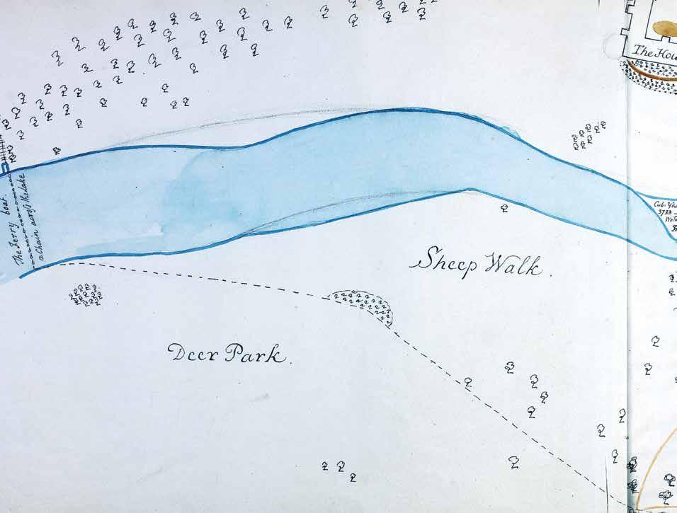
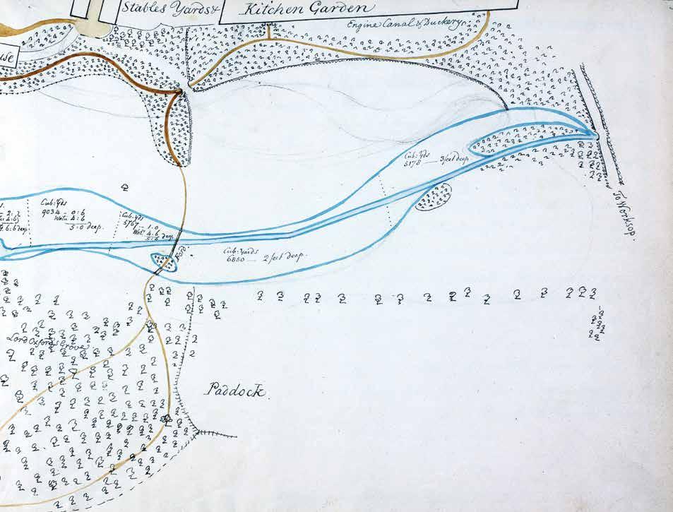
Humphry Repton. Welbeck. Nottinghamshire, England. Lake view with Repton at the theodolite. First Red Book for Welbeck, 1790. [Portland Collection, Bridgeman Images]
2-2
37
44
STEPHEN DANIELS > REPTON FOR REAL: THE PRACTICAL AND PICTORIAL
Humphry Repton. Welbeck. Nottinghamshire, England. Map showing excavation for extension of the lake. First Red Book for Welbeck, 1790. [Portland Collection, Bridgeman Images]
2-6
45
3-2 West 8.
The Phoenix of Espenhain Brown Coal Mine. Lake Strömthal, Leipzig, Germany, 1994. Master plan depicting intervention, restoration, and future development.
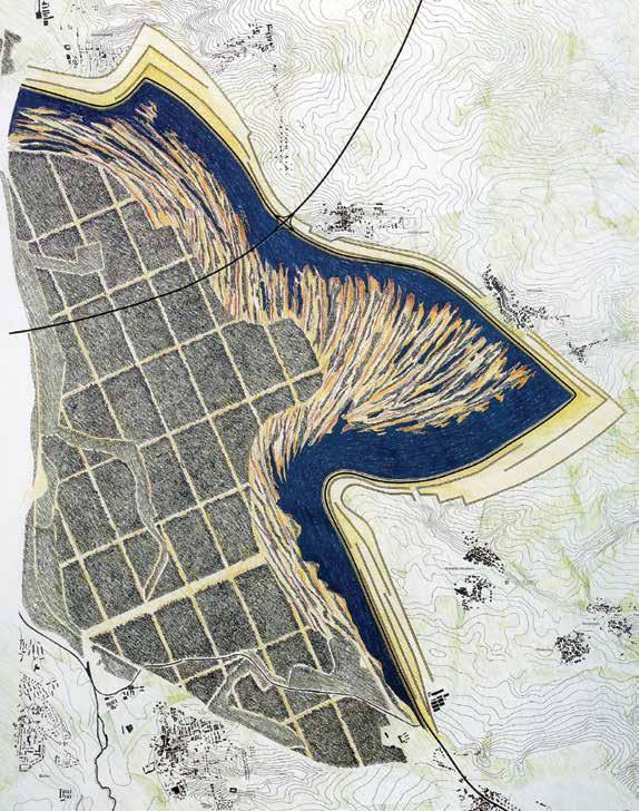
[West 8]
3-3 West 8.
The Phoenix of Espenhain Brown Coal Mine. Stepped sections showing increasing urbanity.
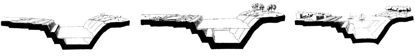
[West 8]
3-4 West 8.
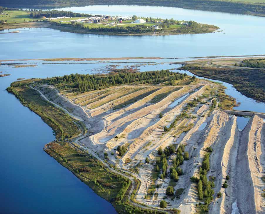
The Phoenix of Espenhain Brown Coal Mine. Contemporary condition of the site, highlighting the lake, the reclaimed island strips, the woodland forest, and agricultural land.
[© euroluftbild de / Robert Grahn]
3-5
West 8.
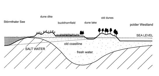
Buckthorn City and Dune Apocalypse. Hoek van Holland, Rotterdam, the Netherlands, 1995. Sections showing three types of dunescape: shallow and salty beach, brackish ecology, and freshwater lake.
[West 8]
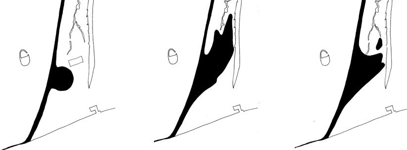
Buckthorn City and the Dune Apocalypse
In response to an urgent request to study the urban extension of Rotterdam and The Hague, West 8 proposed the creation of new land using sand reclaimed from the nearby seabed. Our proposal combined a concern for protecting the land from rising water with the urban and ecological extension of the existing terrain. In response to sea-level rise the vulnerable shores of this segment of the Dutch coastline had been granted priority for the construction of new seawalls. Applying an approach that replaced hard walls with natural forms, the budgets demanded by aggressive engineering works could be employed more beneficially to create a massive dunescape that promoted ecological performance and urban use.
The state of scientific thinking at the time provided the starting point, while the most advanced technological knowledge and innovations utilized by the dredging industry were applied to the project. At the coastal edges we proposed raising the land to five meters above sea level and to protect that new land with a series of dunes. To foster spontaneous ecological activity the new terrain would be retained at a suitable distance from the existing land, enclosing a freshwater lake in the space between as a new ecological reservoir. The resulting sequence of spaces that moved inland from the sea comprised three types of dunescape: shallow and salty beach, brackish ecology, and freshwater lake [3-5].
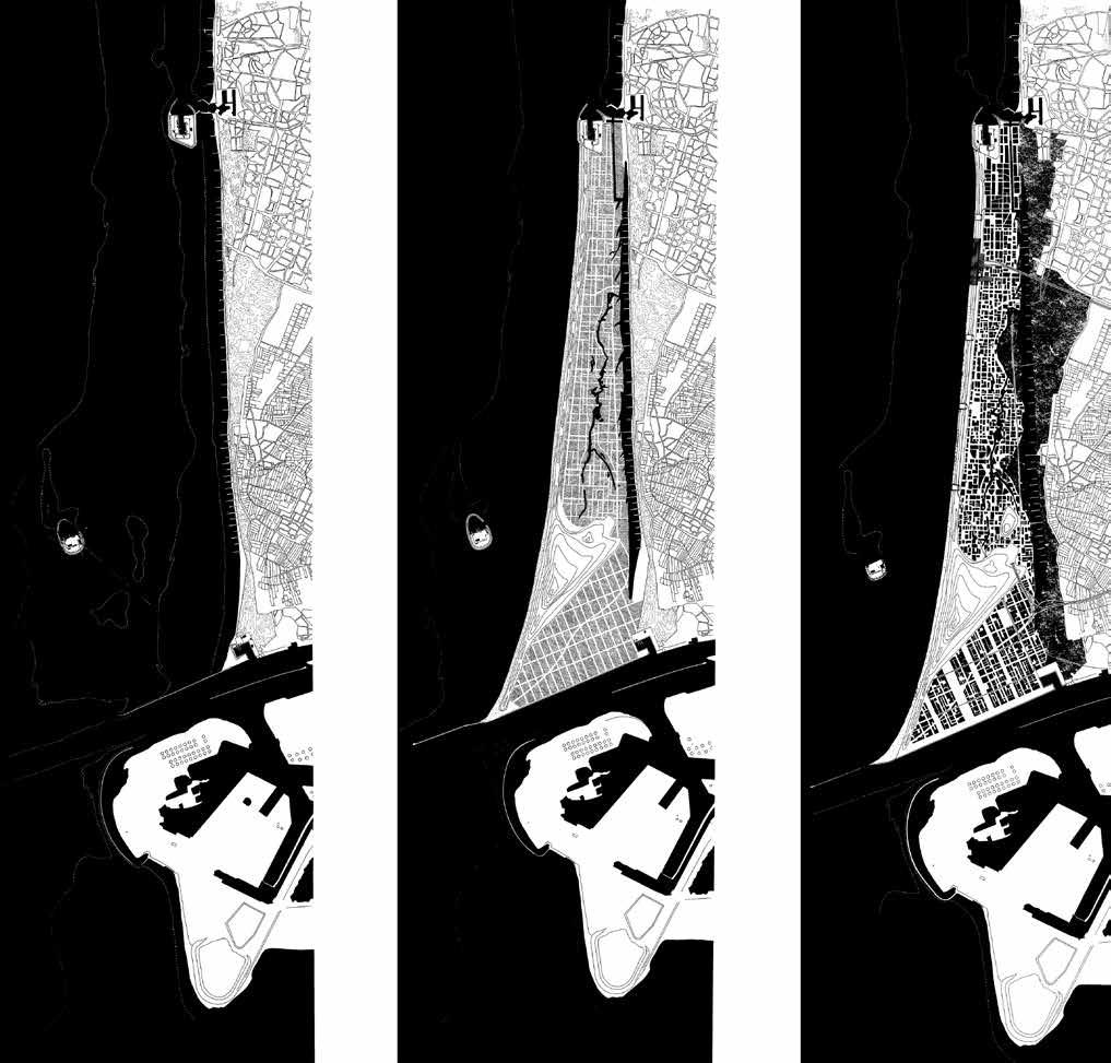
The next layer of the design involved planting dune grasses on the salty side of the site and seeding the brackish side with fields of buckthorn. The geometric layout of the buckthorn reflected the irregular if orthogonal grid of the future streetscape. For the first time, urbanity was designed as a phase of succession, earning the project the name: Buckthorn City [3-6].
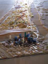
The master plan would require a time horizon of twenty years. Creating four-by-fourteen miles of land the exact area of Manhattan island would demand four years of dredging, 24/7, its yield blown onto the shore. The next step, which would require an additional three years, involved the realization of a four-stop subway line connecting Rotterdam and The Hague to address basic transit needs as well as stimulate the site’s adaptation to mass tourism. The double waterfronts introduce two types of urbanity that anticipate the diverse conditions of the newly born land. The southern portion of Buckthorn City will develop as a modern city with a downtown, boulevards, plazas, and
(opposite above left) 3-6 West 8. Buckthorn City and the Dune Apocalypse. Buckthorn City master plan with three successive phases: existing, buckthorn plantation, and urbanity. [West 8]
(opposite above right) 3-7 West 8. Buckthorn City and the Dune Apocalypse. The dune becomes the identity for the new city. [West 8, 2006]
(opposite below left) 3-8 West 8. Buckthorn City and the Dune Apocalypse. The dancing dune. [West 8]
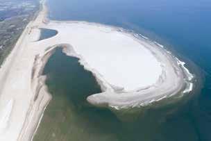
(opposite below right) 3-9 Rijkswaterstaat. Zandmotor. Hoek van Holland, Rotterdam, the Netherlands, 2011. The initial fetal shape of the lagoon, moving and growing over time.
[Joop van Houdt / Rijkswaterstaat]
56 ADRIAAN GEUZE > THE ART OF LANDMAKING
74 BAS SMETS > THE STARTING GROUND
4-3
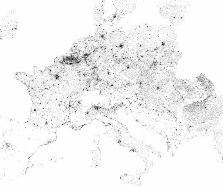
European Environmental Agency.
Population Density Map of Europe, 2017. The flatness of the Belgian terrain provided no resistance to development and has resulted in an endless urban sprawl, visible even from space.
[GEOstata]
4-4
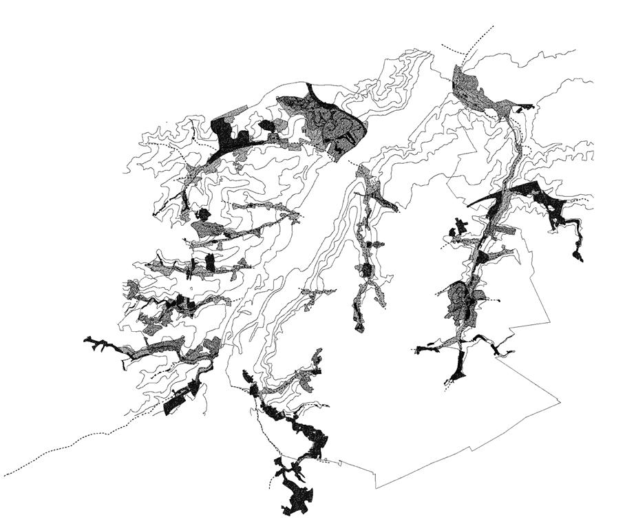
Bureau Bas Smets. Brussels 2040: City of Tributaries, 2012. Brussels as the city of secondary valleys. The reinforcement of Brussels’s eight tributaries creates a new landscape structure that guides development and captures rainwater along the length of large urban parks. Bureau Bas Smets [hereafter BBS].
If one overlays the built space of Belgium on the map of the country’s existing rivers, their lack of correlation is shocking. However, when you look at those waterways in greater detail you understand that these are not major rivers. Our rivers are perhaps 200 kilometers long less than one-tenth of the Rhine or the Rhône, each of which flows through 3,000 kilometers. Their difference in the fall of their land is about 3,000 meters, while in Belgium the difference is perhaps only 100 or 200 meters at most. In conducting our research we came to appreciate what geologists have always known: that in Belgium we mainly have what are called “rain rivers,” that is, rivers with significant flow only during seasons with significant rainfall. In flat terrain any small difference in height becomes significant. The effect parallels that of pouring water onto a glass table: the little cracks in the tabletop determine where the water goes and how it moves. Our office has become obsessed with topography, especially with changes in level as a starting point for developing design. The following five projects illustrate our continually evolving methods and ideas.
Rain River
In 2010 the Brussels government asked our office to produce a vision for the city’s form in 2040. We began with topographic readings, inventorying the elements of the urban fabric to better comprehend what currently existed. In the nineteenth century the city’s main river, the Zenne, was diverted into a subterranean culvert running beneath the center of Brussels. The result: the city lost its river; there was no longer an iconic natural feature to mark Brussels, as the Thames does for London or the Seine for Paris. After uncovering traces of the original waterways we then mapped the city’s green spaces. Our findings puzzled us; there seemed to be no systemic logic behind the locations of these green spaces. However, recalling the larger-scale river study we had conducted, we realized that these open spaces reflected a kind of a capillary system of rain rivers that carry runoff to the North Sea.
Under these conditions the tributary becomes almost as important as the primary river. After we traced Brussels’s eight tributaries on a map it became clear that 80 percent of the city’s green spaces were directly linked to the same system of flow something that geologists know, of course,
75
TEN TOPOGRAPHIC ACTS
126
7.
7-1
MARC TREIB
7-2
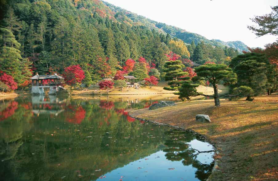 Gunnar Asplund and Sigurd Lewerentz. Woodland Cemetery. Enskede, Sweden, 1915–40. [Maj Wetterstrand]
Emperor Gomizono-o et al. Shugaku-in Imperial Villa. Kyoto, Japan, 1660s–. The Chitose bridge seen from across the pond.
Gunnar Asplund and Sigurd Lewerentz. Woodland Cemetery. Enskede, Sweden, 1915–40. [Maj Wetterstrand]
Emperor Gomizono-o et al. Shugaku-in Imperial Villa. Kyoto, Japan, 1660s–. The Chitose bridge seen from across the pond.
127
All photos by Marc Treib, unless otherwise credited.
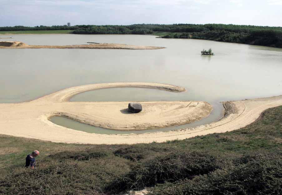
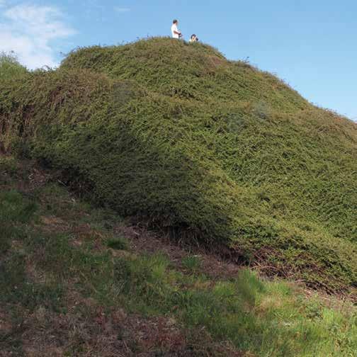
Broken Circle, Spiral Hill
Emmen, Netherlands
1971
Robert Smithson
128
The practice of “cut and fill” transforms topography by removing soil from a rise to fill a depression or level a slope. Ideally, by balancing extraction and deposit all soil remains on-site. In 1971, on the grounds of a sand and gravel quarry in the eastern Netherlands, artist Robert Smithson employed this practice to create an earthwork using only materials found on-site.
Believing that sufficient land had already been despoiled by construction and habitation, and with a predilection for interacting with disturbed terrain, Smithson rejected the offer of a park site for his participation in the 1970 Sonsbeek sculpture exhibition. Instead, Smithson chose a functioning quarry with a residual pond at its heart. His work would comprise two elements: one engaging the water on the quarry’s northern shore, the second piled on the bank adjacent to it [7-3].
From a small peninsula that jutted into the pond, Smithson removed sand and gravel to isolate a spit of land shaped as the arc of a circle. From the bank, he dug a narrow canal with a corresponding curve. The resulting circular figure interlocked land and water in a positive/negative arrangement incorporating the opposition of forces represented by the yin/yang of Chinese philosophy. A rare erratic boulder, the product of the terminal moraine by which much of the Netherlands has been shaped, was appropriated as the center of Smithson’s circle.
Smithson used the sand and gravel from excavating Broken Circle, augmented by the topsoil needed for vegetal growth, to shape Spiral Hill on the adjacent shore. The hill’s tapering profile and path recall the spiral forms of the minaret of the ninth-century Mosque of al-Moutawakel in Samarra, Iraq, as well as the Tower of Babel, famously depicted in paintings by Pieter Bruegel the Elder [7-4].
The pairing of solid and void, not to mention water and land, confirms the broad range and power of forms that may result from even a basic reworking of topography, with materials neither imported nor removed from the site.
7-3
Robert Smithson. Broken Circle / Spiral Hill. Emmen, Netherlands, 1971. Broken Circle.
7-4
Robert Smithson. Broken Circle / Spiral Hill. Emmen, Netherlands, 1971. Spiral Hill, highly overgrown.
129
11-15
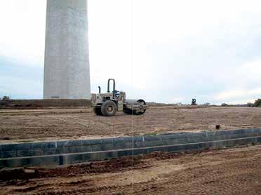
Washington National Monument.
Contouring the knoll. Washington, DC, 2004.
11-16
Laurie Olin and Project Design Team.
Washington National Monument. Washington, DC, 2002. Security-design
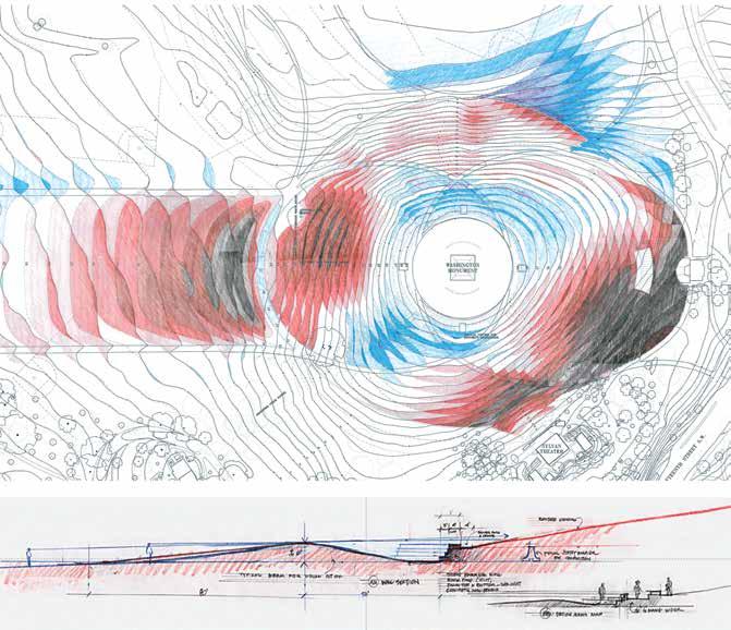 [Kathleen John-Alder]
cut-and-fill grading plan.
(above): Within 200 feet of the obelisk less than one foot of soil was disturbed; (below): Cross section through the security wall, showing the care taken to screen it from the Lincoln Memorial.
[Kathleen John-Alder]
cut-and-fill grading plan.
(above): Within 200 feet of the obelisk less than one foot of soil was disturbed; (below): Cross section through the security wall, showing the care taken to screen it from the Lincoln Memorial.
222
[The Olin Studio]
11-17
11-18
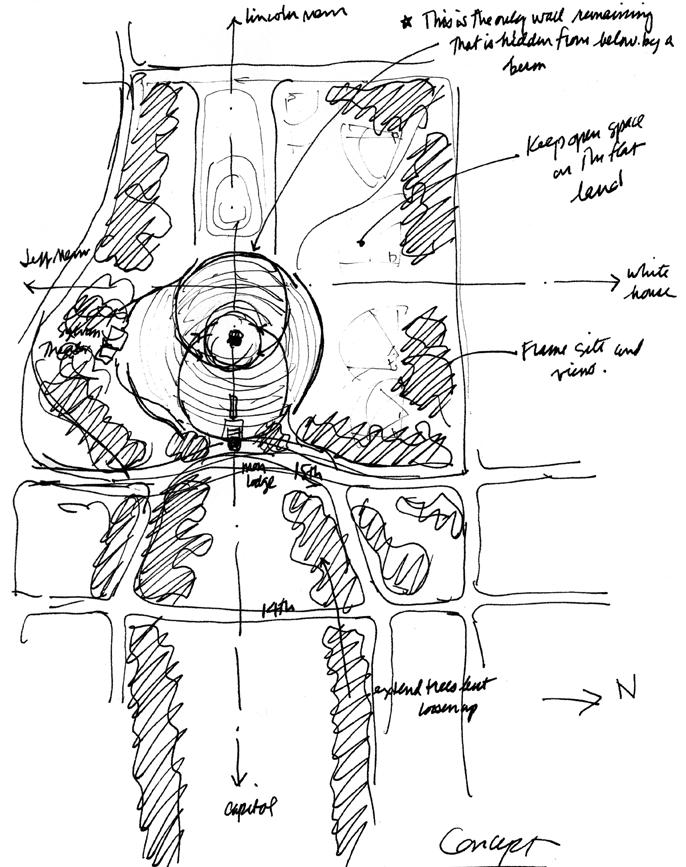 Laurie Olin. Washington National Monument security design. Washington, DC, 2001. Concept sketch. [The Olin Studio]
223
Laurie Olin. Buscot House and Park. England, late eighteenth century. Sketch of the lawn and ha-ha, 1995. [from Across the Open Field: Essays Drawn from the English Landscape]
12-4
SUPERPOSITIONS.
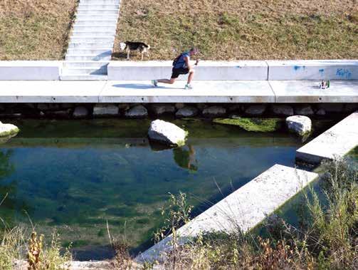
Renaturalization of the River Aire. Geneva, Switzerland, 2000–2021+.
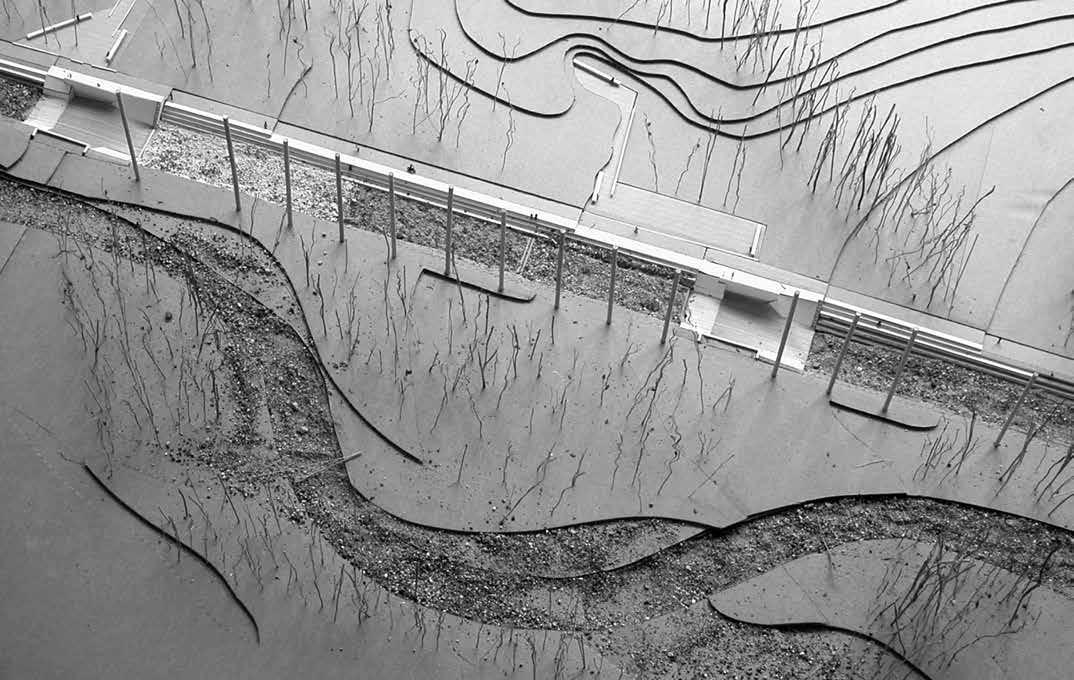
In addition to flood management, the revised river supports year-round recreation.
 [Marc Treib]
12-5
SUPERPOSITIONS.
Renaturalization of the River Aire Study model.
[SUPERPOSITIONS]
232
12-6
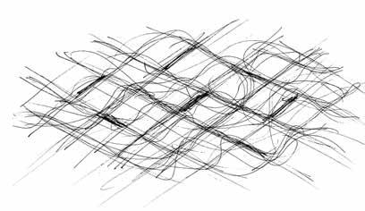
Georges Descombes. Sketch studying river flow. [Georges Descombes]
12-7
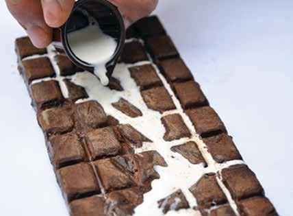
SUPERPOSITIONS. Renaturalization of the River Aire. Geneva, Switzerland, 2000–2021+. Conceptual test using milk and Swiss chocolate.
[SUPERPOSITIONS]
12-8
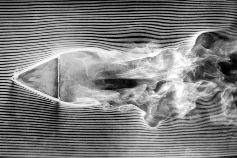
Étienne-Jules Marey. Étude aérodynamiquemachine à fumée avec obstacle, 1901.
[Wikicommons]
234 GEORGES DESCOMBES > TO ACT OR NOT TO ACT
12-9
Tracing water flow around the lozenges. [Georges Descombes]
12-10
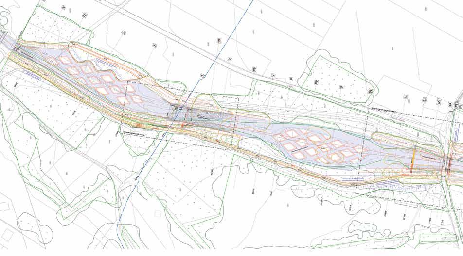
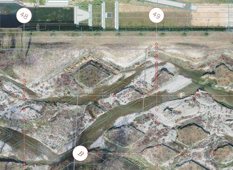
SUPERPOSITIONS. Renaturalization of the River Aire. Geneva, Switzerland, 2000–2021+. Engineering plan showing the lozenge field in relation to the surrounding landscape. [SUPERPOSITIONS]
235
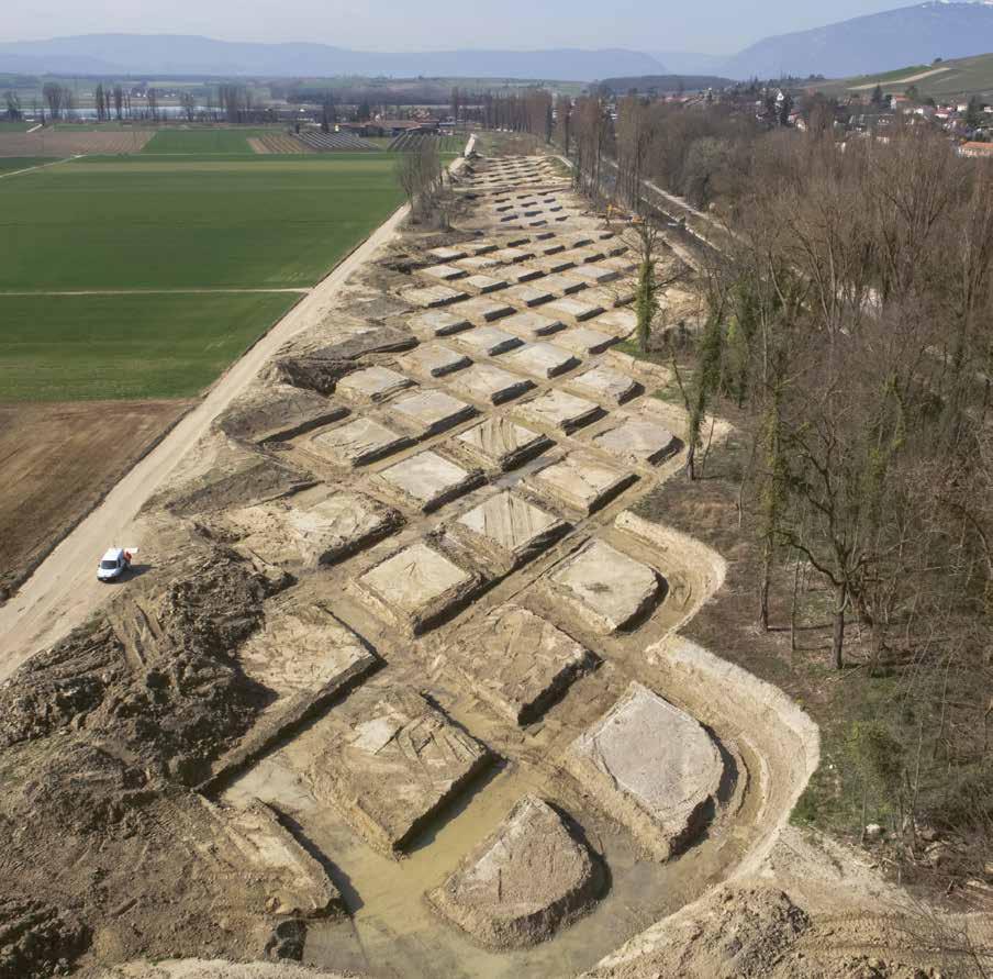
(opposite) 12-11
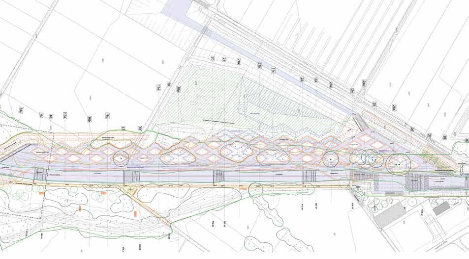
SUPERPOSITIONS. Renaturalization of the River Aire. Geneva, Switzerland, 2000–2021+. The completed lozenge field excavated from the riverbed. [Aerial Works Fabio Chironi]
12-12
SUPERPOSITIONS. Renaturalization of the River Aire. Excavating the lozenges.
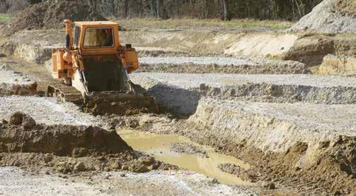
[SUPERPOSITIONS]
12-13
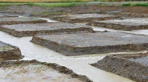
SUPERPOSITIONS. Renaturalization of the River Aire. First stormwater flowing through the lozenge field.
[SUPERPOSITIONS]
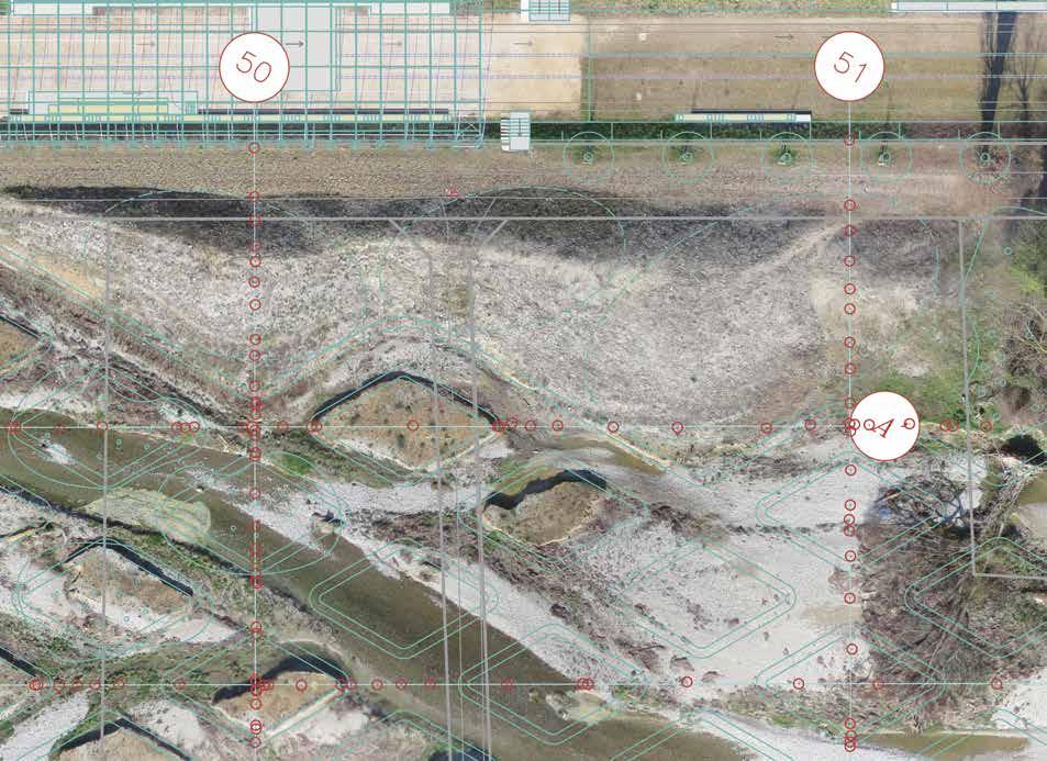
12-14
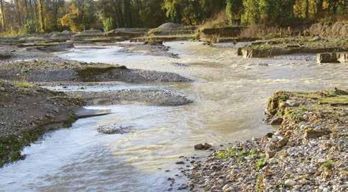
SUPERPOSITIONS Renaturalization of the River Aire. Each major surge modifies the course of the river and its bed.
[Georges Descombes]
238 GEORGES DESCOMBES > TO ACT OR NOT TO ACT
SUPERPOSITIONS. Renaturalization of the River Aire. Geneva, Switzerland, 2000–2021+. Tracking the erosion of the lozenges. [Aerial Works Fabio Chironi]
12-15
239
ACKNOWLEDGMENTS
The Shape of the Land: Aesthetics and Utility, the symposium that provided the basis for this book, took place on the campus of the University of California, Berkeley, in March 2020, three days before the university closed in response to the outbreak of Covid-19. Unfortunately, because of the disease’s rapid and widespread impact on both professional and personal lives, and subsequent travel restrictions, three of our speakers were unable to attend. For different reasons, Georges Descombes and Jennifer Guthrie faced travel issues and could not; Elissa Rosenberg was hampered by quarantine restrictions but participated using Zoom —in my own experience, the earliest use of a program that would govern many of our lives in the years that followed. Fortunately, although missing the symposium, all three would-be speakers have contributed essays to the book.
The planning of the symposium was co-curated with Louise Mozingo, chair of the Department of Landscape Architecture and Environmental Planning, which sponsored the event. The program was a true collaborative effort, and I thank Louise for her support. Her input, and that of the departmental staff and students, was critical for the successful mounting of the symposium and the making of this book, which follows two years later. In addition, Louise’s Richard and Rhoda Goldman Distinguished Professorship provided a generous subvention for this publication. I am most grateful to departmental staff Jessica Ambriz and Sue Retta, who played crucial roles in handling travel arrangements, logistics, and financial matters, and could not have been more effective or pleasant to work with. In addition to processing the videos of the presentations and putting them online, Jeff Allen handled a myriad of other conference details, including also unprecedented at that time the installation of hand-sanitizer stations throughout the symposium site; to our knowledge, no one at the symposium fell ill. I thank them all.
280
Of course, I must also offer thanks to all the speakers, now authors, some of whom traveled to Berkeley across thousands of miles of land and sea, and for their efforts in providing or reviewing texts, as well as the visual material used to illustrate their ideas and works. As noted above, the impact of Covid-19 on the initial symposium and on the lives of the speakers thereafter made producing the book a considerable challenge. Given the chaos in everyone’s lives caused by the pandemic, my appreciation is even greater than it would have been under more normal circumstances.
I thank Jane Friedman for her excellent and expeditious copyediting of texts by those who hail from many different landscapes and who typically write in languages other than English. Alicia Moreira provided insightful proofreading, precisely noting those slips of the mouse or cursor. And lastly, I must thank, once again, ORO Editions publisher Gordon Goff for his support of our work, and Jake Anderson for his skillful and efficient management of the production process. Our relationship in publishing a number of books together has been ideal.
I am again most grateful for the substantial financial support for the publication of this book provided by the Hubbard Educational Trust and the Richard and Rhoda Goldman Distinguished Professorship, University of California, Berkeley.
All involved with The Shape of the Land: Topography & Landscape Architecture sincerely hope that the substantial time and effort spent in its writing and production has resulted in a book that readers will find informative and a catalyst for their own thinking and work.
281
MT
CONTRIBUTORS
Marc Treib, Professor of Architecture Emeritus at the University of California, Berkeley, is a historian and critic of landscape and architecture who has published widely on modern and historical subjects in the United States, Japan, and Scandinavia. Recent books include The Landscapes of Georges Descombes: Doing Almost Nothing; Thinking a Modern Landscape Architecture, West & East; The Aesthetics of Contemporary Planting Design; and Serious Fun: The Landscapes of Claude Cormier
Stephen Daniels is emeritus professor of cultural geography at the University of Nottingham, a landscape historian, and a fellow of the British Academy. His numerous writings include the coauthored Iconography of Landscape, which broke new ground in cultural landscape studies, and Art of the Garden. Well versed in numerous landscape subjects, he is also known as the leading authority on Humphry Repton, his theories, and landscapes.
Georges Descombes is an architect, landscape architect, and emeritus professor of architecture at the University of Geneva, whose work has been widely published and awarded. He has undertaken numerous projects both within Switzerland and abroad, including the Jardins d’Éole in Paris and the Parc de Lancy in Geneva. His decades-long project for the renaturalization of the River Aire outside Geneva has become a model for all design work in this arena.
Adriaan Geuze is a founding principal of West 8 Urban Design and Landscape Architecture, based in Rotterdam, the Netherlands, with numerous works there and in Britain, Europe, and Asia. Recent projects include the Rotterdam railroad station and its environs, Governor’s Island in New York, and the water garden at Longwood Gardens in Pennsylvania.
282
Jennifer Guthrie, FASLA, is a founding partner of the Seattle-based Gustafson Guthrie Nichol (today GGN )—the recipient of the 2017 American Society of Landscape Architects’ National Landscape Architecture Firm Award. GGN’s work ranges broadly, encompassing urban districts of green streets and mixed-use housing, public squares, rooftop gardens, urban farms, and cultural institutions.
Kathleen John-Alder, FASLA, is Associate Professor of Landscape Architecture at Rutgers University, a practicing landscape architect, and scholar who explores the interplay of environmental perception, representation, and design. She holds degrees in environmental planning and landscape architecture from Rutgers, Pennsylvania State University, and Yale University, and has received numerous awards, including those from the National Park Service and the American Society of Landscape Architects.
>
Ana Kucan is Professor of Landscape Design and Theory at the Biotechnical Faculty of the University of Ljubljana, Slovenia. She holds an MLAUD degree from Harvard University and a PhD from the University of Ljubljana, and is a principal in the landscape architecture and urban-design studio Studio AKKA, which she founded with Luka Javornik in 2007. Her landscapes and urban-design projects have been exhibited in Slovenia and abroad, and have received national and international awards.
Karl Kullmann, Associate Professor of Landscape Architecture and Urban Design at the University of California, Berkeley, teaches design studios and digital representation, and maintains a selective design practice. His research and publications have addressed the cultural agency of complex topography as well as issues of representation and those facing landscape-architectural practice and education. 283
José Miguel Lameiras is Professor of Landscape Architecture at the University of Porto, Portugal, and a researcher in the university’s Research Center in Biodiversity and Genetic Resources. He holds a PhD from the University of Porto; his dissertation explored the use of digital terrain design incorporating state-of-theart developments in Building Information Models.
David Meyer was a senior partner at Peter Walker Partners before establishing Meyer Studio Land Architects in Berkeley. In addition to practice, he serves as Adjunct Professor of Landscape Architecture at the University of California, Berkeley. A fellow of the American Academy in Rome, he credits his Iowa origins with his love of simple, sensual, deliberate designs that judiciously employ nature’s palette.
Elissa Rosenberg, Associate Professor at the Bezalel Academy of Arts and Design, Jerusalem, studies the ways in which topography has been used as a generative idea and expressive medium in landscape design, and how the shaping of the ground is bound up with ways of seeing, moving, and knowing the world. Her research has focused on contemporary landscape architecture and urban design, including postindustrial landscapes and urban infrastructure.
Bas Smets is the principal of Bureau Bas Smets, based in Brussels, Belgium, a practice whose work spans the small scale of the garden to large-scale infrastructure and territorial visions. Recent projects include the Tour & Taxis Park in Brussels; the landscape for the new motorway between the ports of Antwerp and Zeebruges; and the memorial for the victims of the 2016 terror attacks in Brussels.
Laura Solano is principal at Michael Van Valkenburgh Associates (MVVA), where she oversees the firm’s projects in the Cambridge office, and has played a significant role in MVVA’s award-winning projects for Teardrop Park in New York and the Jefferson National Expansion Memorial in St. Louis. She also serves as Associate Professor in Practice at the Harvard Graduate School of Design, where she has taught grading for many years.
284 CONTRIBUTORS