Villefranche-sur-Mer


From the Wilson square take the side street called Chemin de Ronde which goes around the fortress and links the old town to La Darse port. Continue on the path and through the car park to join La Corderie quay then continue straight on Le Lazaret pathway, a small road leading to a residence. Go past the barrier and follow the road to the end. The last building seems to block the access, but crossing it from underneath the arches, you will find the coastal pedestrian path located near the little Paganini tower and its colorful earthenware glazed roof.
This secure path will take you up and down a succession of steps dug into the rocks, you will pass the Madame and the Gaton headlands and will arrive at the blockhouse of the headland called «pointe des Sans-Culottes».
Climb the long flight of stairs and you will arrive on the main street Maurice Maeterlinck boulevard. Take left and follow the road on 700m until Casa Pizza pizzeria. Take the first left onto Cap de Nice avenue until you will see, next to a private property gate a long flight of stairs (follow the yellow markings) descent until you will arrive to a well paved pedestrian path by the seaside. Take right to follow the path, continue towards the port of Nice.

Level : medium
Time : 2 hours
Distance : 3.7 miles
Height : 951 feet


From the car park of the Citadel, if you walk up the “rue de l’Eglise”, you will arrive the “place de la Paix”. From there, if you continue along “rue de la Victoire” which becomes “avenue Gallieni’’ and cross the main road “basse corniche” (RD6098), you will find the steps of “Campo Quadro”. Up the next set of steps you will find the“moyenne cornice (RD6007)”.
Take a left along this road, there is a pavement on the left, for about 1,500 feet until

you get to a crossroad at the “col de Villefranche” (traffic light). Then take the small asphalted road up on your left to the “Mont Alban” past “Notre Dame de France” church. Keep walking up toward the fort (about 700 feet) ignoring the secondary paths. From the fort, walk straight down the main road at Mont Alban until you find the fitness circuit. From there, follow the zigzag path to your left between the pine forests until you get to a view point over the bay. The steps down from here called “escaliers de Verre”, end up back at the “basse corniche”.
Cross the road (a cross-roads is indicated but there is no pedestrian crossing) and keep walking along the pavement in the direction of Villefranche. About 350 feet further along you will find the next set of steps “24ème BCA” which will take you down to the port of the “Darse” and then back round to the Citadel.

Level : Easy
Time : 2 hours
Distance : 3 miles
Height : 720 feet


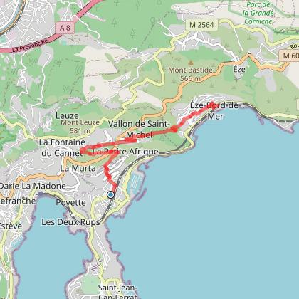
From Beaulieu train station, walk East and take the “Eugène Gauthier” avenue. Walk along until you get to the “montée des Mandarines”.
©

Take the road that begins between houses and continues with a series of steps that climb up towards the neighborhood known as “Petit Afrique”. Then cross the “Édouard VII” boulevard to find a horizontal path that runs alongside the flowers. Continue on the right and keep on walking along the zigzag path until you get to the “moyenne corniche” avenue (RD67).
Then you can descend through the small St. Michel valley and on through the “Libac” path, that first cuts across and then crosses along the narrow road RD34 before plunging into the woods. You will notice the charming “St. Grat” chapel (1817) as well as the St. Michel’s castle (private).
Continue down, close to where the three paths intersect, cross the valley reached by a horizontal path, where you will pass by many beautiful houses into the center of Eze-sur-Mer and the “basse corniche” via the steps that cross “avenue Provence’.

Level : intermediate
Time : 3 hours
Distance : 3 miles
cirkwi.com


Go to the entrance of the old town and continue along “quai Courbet”. Go throught “Portail Robert”, and turn right at the “rue Obscure” (which becomes narrower as you advance). This continues into the “rue de Poilu” which if you continue to the end leads to the train station. From there, walk
up the road “Chemin de la Foan’’ which leads up to the “basse corniche” (RD6098);


be careful crossing as there is no pedestrian crossing; continue following the road “basse corniche” (direction Monaco). Then, take the first to the left, “chemin de la Madone Noire”. You will go through a small valley and cross a metallic bridge. Enjoy the last panoramic view before the flat alley which ends at the “chemin de Suède”.
Then walk all the way down the “Chemin des Serres” through the floral cultivations and take the stairs that will take you to the crossroad of SaintJean-Cap-Ferrat. Cross it and take the “Grasseuil” avenue for about 160 feet and then becomes “Louise Bordes” avenue. At the end of that avenue,
you will find the steps that will lead you down to the “promenade des Marinières” at Villefranche-sur-Mer. Walk along the sidewalk that runs alongside the walls covered with bougainvillea.

Level : Easy
Time : 1h30
Distance : 2,5 miles
Height : 330 feet
randoxygene.departement06©
 randoxygene.departement06©


With over 10,000 species of flowering plants, the Mediterranean region has an exceptionally rich flora. Most of these are native to the region, but a significant number of species have been imported from places as far away as South Africa and North America.
The olive tree: Symbol of Provence, longevity and serenity, the olive tree is a fruit tree that produces olives, a fruit consumed in various forms and from which olive oil is extracted. The olive tree is often used as a a reference plant for the climatic limits of the Mediterranean area.
Aleppo pine : This is a Mediterranean species that thrives on the chalky soils of the coast. Its foliage is light and airy, its trunk often twisted and bent and its bark grey.


The carob tree: Native to the Middle East, it was once cultivated by the peoples of the Mediterranean region for animal feed. It produces a particular fruit; a 10 to 20 cm long chocolate-coloured pod.
Cottony rockrose: Also called white rockrose, it owes its name to the appearance of its downy leaves. It is a characteristic shrub of the scrubland with spectacular spectacular pink flowers that look like crepe.


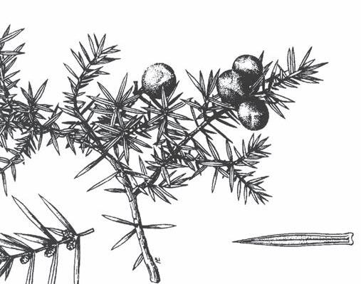
Cade juniper: This is one of the characteristic plants of the garrigues and the maquis. Cade is known for the essential oil extracted from the heart of the wood, whose disinfectant, anti-allergic and healing properties make it an ingredient in many soaps and dermatological products.


The lazaretto was built in the middle of the 17th century, in the farthest corner of the port of La Darse. It was used to quarantine or «purge» men and especially goods in order to avoid importing plague or cholera from the Levant.
It is also known as the «Paganini» tower because, it is said, this is where the remains of the the famous violinist’s remains were deposited there after his death, before being transported to Italy.

The Mont-Alban fort is a bastioned military construction from the second half of the 16th century, located on the hill of Mount Boron overlooking the bay of Nice and the harbour of Villefranche-sur-Mer. Together with the citadel, it constituted one of the points of of the coastal protection system.


No rubbish on the floor
Stay on the trails
Respect the fauna and flora
Keep the control of your dog


Not throwing cigarette ends
No fire or barbeque

Respect for the other walkers
Unsupervised swimming /!\
Côte d’Azur France
www.villefranche-sur-mer.com

Nice Côte d’Azur Metropolitan Convention and Visitors Bureau
Villefranche-sur-Mer Office
Jardin François Binon - 06230 Villefranche-sur-Mer
Tél : + 33 (0) 4 93 01 73 68
info.villefranchesurmer@nicecotedazurtourisme.com
Find us:
www.explorenicecotedazur.com
FB @exploreNiceCotedAzur - Instagram @explorenicecotedazur
Twitter @ExploreNCA #explorenicecotedazur


www.villefranche-sur-mer.com