17 minute read
From a secret cold war project to the future of the ice sheet


Advertisement
You’re about to embark on a journey to Camp Century, a nuclear-powered U.S. Army base built in 1959 and 1960. It was a grid of thousands of feet of snow tunnels dug into the Greenland Ice Sheet*. You might feel like you’re watching an old James Bond movie or even entering a science fiction novel, right?! Yet, the science born out of this military adventure is anything but fiction. Recently, alarming secrets about the potential future of the Greenland Ice Sheet have come to light from sediment at the bottom of an ice core collected beneath the base.
Story and interview: Andrew Christ and Paul Bierman
Figure 1: Historic map of northwestern Greenland showing the location of Camp Century (yellow circle) (image credit: Clark 1965).
During the Cold War in the 1950s, the threat of Soviet attack over the Arctic Ocean led to a military build-up in the far north by the U.S. and its NATO allies. In northwestern Greenland, the Danish government allowed the U.S. to construct Thule Air Base in 1951. The airbase hosted sensitive radar and a runway long enough for strategic bombers; Thule could house up to 10,000 people.

With Thule as a base, the U.S. military began to explore the arctic using motorized convoys and airsupported expeditions. In 1953, they built the first camps in the ice, known as Sites I and II; these were radar installations disguised as weather stations. The bases were metal tubes under the snow filled with insulated barracks and they worked – 18 soldiers lived at 25°C (77°F) while the winds howled above them.
Figure 2: Aerial view of the heavy swing transporting supplies to Camp Century from Camp Tuto (image credit: Wright 1986).


Figure 3: The beginings of a snow trench that will soon be deepened (image credit: Wright 1986).

A few years later, the Army began hauling men, construction materials, and machines across the ice sheet to build a different type of base. They went big and used native materials, snow, and ice for construction. First came Camp Fistclench, nearly 300 km (200 mi) from the edge of the ice sheet. Trenches were dug out of the snow by Swiss Peter Plows that once cleared deep snow from passes in the Alps. Then, the trenches were roofed with wood and metal arches and snow blown on top – it quickly sintered to form a hard, camouflaged roof.

Figure 5: Camp Century from the air was almost invisible (image credit: Leighty 1963).
The proof of concept worked, and soon the same engineers designed Camp Century, named after the planned distance along the ice road, 100 miles (160 km). But nature didn’t cooperate, and the right site, one flat enough to build the camp in the dry snow zone, was actually 138 miles (222 km) from the edge of the ice sheet. Men, materials, and fuel moved to Camp Century across the ice in heavy swings, tractors pulling sleds including heated living quarters and mess halls. The swings moved at about the speed people could walk, and took three days to reach Camp Century from Thule.

Figure 4: Swiss Peter Plow excavating trench (image credit: Nielsen et al. 2014).

Figure 7: An artist's view of the the camp (image credit: R.C. Magis, E.M. Scheel, National Geographic Magazine, https://campcentury.omeka.net/items/show/295).
Between 1961 and 1963, Camp Century was powered by a small nuclear reactor and housed over 100 soldiers, scientists, and engineers, all of whom lived in heated, insulated, prefabricated buildings within the tunnels cut into the snow (Fig. 7). Camp Century was a chilly place to walk around since the interior temperature was kept well below freezing, which was necessary to keep the snow tunnels intact!
Camp Century was highly visible to the public and used as a Cold War propaganda tool in the U.S. The army welcomed coverage from media outlets including National Geographic, Popular Science, and international newspapers (Fig. 8). To optimize military operations in the challenging and harsh Arctic environment, the U.S. Army needed scientists to study the ice and snow itself. It's also possible that the U.S. had a more insidious motive: a secret mission called Project Ice Worm that sought to hide nuclear weapons and move them by rail inside the Greenland Ice Sheet — away from prying Soviet eyes. However, this project was never fully realized — not even close, although a short section of railway was built in one of Campy Century’s tunnels.

Figure 8: Camp Century was important enough to make the cover of Popular Science in full color!
In the meantime, snow and ice scientists went to Camp Century. Their purpose was to study the properties of ice and snow, drill into the ice sheet, and learn more about Earth’s climate history preserved in the ice and snow.
Swiss scientist Henri Bader convinced the U.S. military they needed to understand the fundamental properties of snow and ice in order to operate at the poles. Bader had other motives as well: by 1950 he suspected that ice cores drilled in glaciers and ice sheets would recover the annual layers of snowfall that would preserve important records of climate and atmospheric composition.
Chester Langway, a young American scientist, was brought by Bader to Greenland in 1956 and began collecting shallow ice cores (a few hundred meters, or up to 1000 ft) from other military outposts on the ice sheet and developing methods for measuring important variables on the ice samples. In 1960, with funding from the recently established U.S. National Science Foundation, Chester Langway and chief drilling engineer B. Lyle Hansen set out on the most ambitious ice-core drilling project yet (Fig. 1, 9–11). Coring at Camp Century was first done using a thermal drill, but this was largely unsuccessful. In the last year, a mechanical drill was repurposed from the oil fields and worked like a charm. The project ended on 4 July 1966 when the borehole, over 1300 meters (4200 ft) long, reached the bottom of the ice sheet and kept going into the sediment below. The cores were stored in the U.S. from then until they were sent to Copenhagen in the early 1990s and vanished; some were only rediscovered by Danish scientists in 2019.
The hypotheses of these early climate scientists proved to be correct, and the data retrieved from the samples exceeded all expectations.


Figure 9: The Camp Century drill trench (image credit: C. Langway, U.S. Army Corps of Engineers). Figure 10: A piece of the Camp Century ice core comes out of the hole (image credit: C. Langway, U.S. Army Corps of Engineers).

Figure 12: A visualization of the Greenland Ice Sheet at Camp Century based on ice radar data (image credit: NASA's Scientific Visualization Studio).

Figure 13: Camp Century after abandonment (image credit: F.J. Leskovitz).
The Camp Century ice core recovered a climate record extending through the entire Holocene (0–11,700 years ago), through the last ice age* (11,700–115,000 years ago) and included part of the last interglacial* period. It was an engineering feat that has yet to be repeated because the drilling engineers retrieved the thickest (~3.5 m or 11.5 ft) subglacial sedimentary sequence recovered from Greenland (Fig. 11).
Even before the ice core was collected, the U.S. Army realized that storing nuclear weapons inside the ice sheet was a bad idea. The weight of the annual snowfall began to collapse the ice tunnels and crush building structures from above while the flowing ice was deforming and compressing the ice tunnels (Fig. 13). The army abandoned Camp Century in 1966, but the ice-core project proved to be a boon for the nascent field of climate science. Now, over half a century later, scientists are still learning from this invaluable climate record.

INTERVIEW
PAGES scientists interviewed Andrew Christ and Paul Bierman, two geologists studying how glaciers and climate change have altered landscapes in the polar regions through time. They are both based at the Gund Institute for Environment and the Rubenstein School of Environment and Natural Resources at the University of Vermont, USA. In Figure 14, Drew and Paul are processing sediment from under the ice at Camp Century.

Andrew and Paul recently led a study based on samples of sediment taken from below 1.4 km (0.9 mi) of ice at Camp Century (Fig. 15, 16) that had been forgotten in a freezer in Denmark for decades! They told us how they found ancient twigs and leaves in those samples that hold lessons about climate change and information about the potential fate of the Greenland Ice Sheet.
Figure 14: Paul Bierman (left) and Drew Christ working in the laboratory (image credit: L. Williamson).
The Camp Century ice core was drilled in the 1960s; how is it that some of the material had not been used until your recent study?


While the 1.4 km-long (0.9 mi-long) ice core revealed Earth’s climate history of the past ~100,000 years in fantastic detail, the very bottom of the ice core – about 17 m (56 ft) of sediment-rich ice and 3.5 m (11 ft) of frozen sediment from beneath the ice sheet (Fig. 11) – had not been studied as intensively. By the mid-1990s, the most interesting samples from Camp Century had been sent to Denmark, and more recent polar ice-core drilling projects were keeping scientists busy. Back then, the samples were transferred from the ice-core storage facility in Buffalo, NY, USA, to the ice-core repository in Copenhagen, Denmark. But the boxes were left unopened, and eventually scientists thought that the samples of sediments from the bottom of the Camp Century ice core had simply been lost. What a happy surprise when Jørgen-Peder Steffensen, the curator of the Danish ice-core storage facility, found the Camp Century ice and sediment inside some glass jars in a freezer a few years ago!
Figure 15: Drew Christ showing a Camp Century soil sample (image credit: K. Kasic).
Figure 16: A portion of the deepest frozen Camp Century sediment that could be an ancient permafrost soil as old as 2.5-3.0 million years old (image credit: D. Christ). PAGES HORIZONS • VOLUME 2 • 2022 61
What sort of analyses did you do on the basal sediment samples?
While we were sorting the Camp Century sediment samples from 10 cm (4 in) below the bottom of the ice sheet into different grain sizes (Fig. 17), we noticed some black specks floating in the rinse water. We looked at them under the microscope and were shocked to discover fossil remains of freeze-dried tundra vegetation! We were looking at delicate leaves, stems, and twigs from an ancient ecosystem preserved beneath 1.4 km (0.9 mi) of ice (Fig. 18). This was incredibly surprising to us because glaciers typically erode and pulverize the landscape; yet, these delicate plants had remained intact.
We knew immediately that our discovery of the frozen plants was significant because they provided evidence that the ice sheet had melted and a tundra ecosystem emerged in northwestern Greenland in the past.
We were excited to perform more analyses on those samples to learn more, and for that we worked with a large team of international scientists from several disciplines (see the green box at the end of this paper).
For instance, so-called “luminescence” measurements were used to identify when the last time the sediment was exposed to sunlight when the ice sheet had melted away. In order to collect luminescence measurements on the sediment, people cutting the core worked in a -20°C (-4°F) freezer using only photography darkroom lights (Fig. 19). Molecular indicators were studied to determine if any information about past ecosystems was preserved in the sediment.

Figure 17: Basal sediment from Camp Century core (image credit: D. Christ).
Figure 18: Twigs and leaves from Camp Century soil sediments (image credit: D. Christ, D. Peteet).

What did you learn from your analyses?
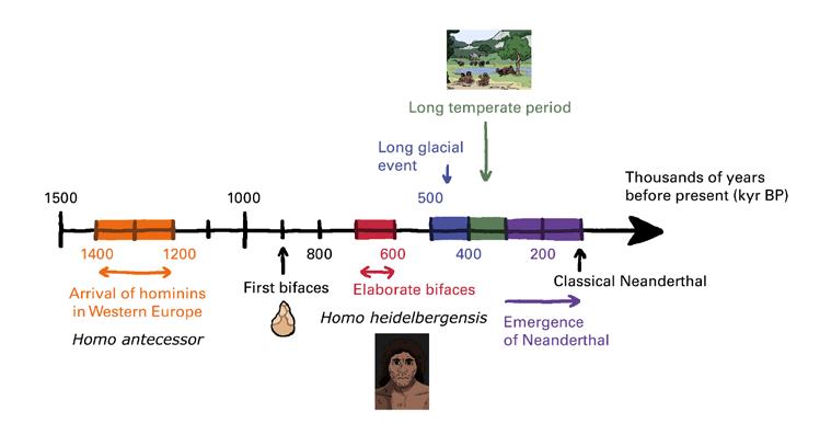
We learned that the sediment from the bottom of the Camp Century ice core captures snapshots of times in the geologic past when the ice sheet had melted away and the tundra ecosystems emerged in northwestern Greenland. We found plant fossils and organic molecules from ancient tundra ecosystems when northwestern Greenland was ice-free: once in the Early Pleistocene, as long as 2.5-3 million years ago, and another time in the last million years. Similar results from measurements in bedrock in central Greenland suggests that much of the ice sheet melted and re-formed at least once during the past million years.

First, it is important to note that many questions remain difficult to answer because it is challenging to determine exactly when and how much of the ice sheet melted in the past. Most soils and sediment deposits that could tell us when and where the ice sheet was present or absent in the past are difficult to access and analyze, because the thick ice sheet on Greenland today is covering them. Information inferred from sediments deposited on the seafloor around Greenland suggest that the ice sheet may have been smaller during several warm interglacial periods over the last million years or so, but we cannot know the size of the ice sheet at those times.
One possible reason that portions (maybe even large portions) of the ice sheet melted, was the long duration of interglacial warmth in the polar regions. In particular, there was an interglacial period about 400,000 years ago that was very long compared to the other ones, lasting about 29,000 years (most last fewer than 15,000 years). The long duration of warm temperatures may have led to extensive melting and retreat of the ice sheet. Paleoclimate archives, both globally and offshore of Greenland, suggest that the Greenland Ice Sheet was smaller during this time, forests inhabited southern Greenland, and global sea level was 6 to 13 m (20–43 ft) higher than it is today. But we do not have evidence from a climate archive on the Greenland landmass – yet – to directly determine how much smaller the ice sheet was then.
How does Camp Century look today, and how did it look back when there was no ice?
Today in northwest Greenland you have to imagine a very flat and white landscape. At Camp Century, the thickness of the ice sheet is about 1.4 km (0.9 mi) and the remnant of the base is currently buried under 65 m (210 ft) of snow and ice (Fig. 20)! But back in the geologic past when it was deglaciated, the landscape was mountainous, and probably dotted with small ponds and lakes that hosted a treeless, tundra ecosystem, where the subsoil was permanently frozen (Fig. 21).

Figure 20: Camp Century today (image credit: GEUS).

Figure 21: What northwestern Greenland possibly looked like during ice-free periods (image credit: J. Brown).

Figure 22: Ice-free Greenland landscape (image credit: J. Brown).
Why does your study matter in the context of current and future climate change?
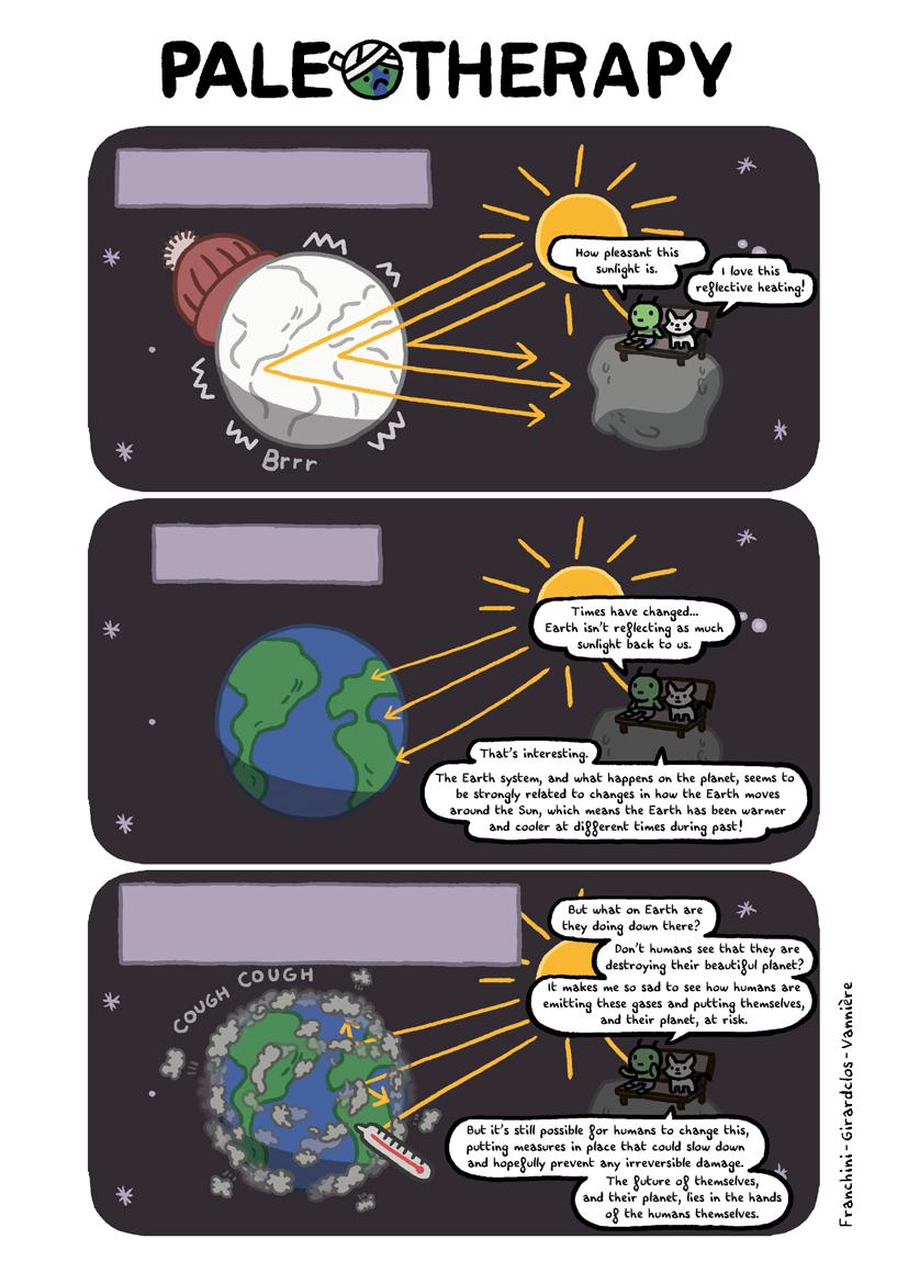
The melting of the northwestern Greenland Ice Sheet within the past million years is important because this region is among the most vulnerable sectors of the ice sheet to climate warming. When we first found the freeze-dried plants in this frozen sediment, we realized how different Greenland must have been for a tundra ecosystem to emerge in a place currently covered by 1.4 km-thick (0.9 mi-thick) ice. A warmer Arctic with a smaller, or even non-existent, Greenland Ice Sheet could also result in the emergence of tundra and forest ecosystems in areas presently covered by ice. Such ecosystem shifts would result in more climate impacts because it would change how much solar radiation is reflected back into space, and how carbon is removed from the atmosphere by vegetation (Normand et al. 2013). Within the last 30 years, ice-mass loss from Greenland was greatest in northwestern and southeastern Greenland (Smith et al. 2020). As these sectors of the ice sheet continue to melt now and into the future, they will contribute a lion’s share of Greenland’s addition to sea-level rise. It is a warning that melting even the margins of the Greenland Ice Sheet would have immense consequences for sea-level rise in the coming centuries. Understanding the stability of these areas of the ice sheet in the past can provide critical information about how much ice we could expect to melt in the future.
But all of these changes in the geologic past happened without any human influence. Humans are rapidly altering the climate system by burning fossil fuels and raising atmospheric CO2 concentrations far above levels observed over the last 800,000 years (Past Interglacials Working Group of PAGES 2016).

Figure 23: Camp Century subglacial sediment project: collaboration home institutions (image credit: N. Bouttes).
A “text-book” example of international and multi-disciplinary collaborative science
There is less sediment from the bottom of ice cores from Greenland or Antarctica than there are moon rocks that have been brought back to Earth! As such, this project could not have functioned without strong collaborations. In order to perform as many analyses as possible on a relatively small amount of material, Andrew and Paul are working closely with an international team of scientists from a wide range of disciplines. Meeting in person at first in 2019, they determined which analyses to carry out and developed protocols for how to process and distribute sediment samples to the different labs involved across the USA and the EU (map above). As the global pandemic hit, all interactions had to move online. The team continued to communicate regularly by email, to present new results in online meetings, and to submit abstracts to scientific conferences as a team. We were successfully awarded a U.S. National Science Foundation grant in 2021 to analyze the entire archive of frozen sediment from the bottom of the Camp Century ice core; the grant will last through 2023.
References
Clark EF (1965) Technical Report 174: Camp Century: Evolution of concept and history of design, construction, and performance. U.S. Army: Cold regions research and engineering laboratory, 69 pp
Fountain J et al. (1981) J Glaciol 27: 193-197
Leighty RD (1963) Special Report 56: Pictorial performance study of Camp Century (1960-1962). U.S. Army: Cold regions research and engineering laboratory, 20 pp Nielsen KH et al. (2014) Sci Cult 23: 443-464
Normand S et al. (2013) Philos Trans R Soc Lond B Biol Sci 368: 20210479
Past Interglacial Working Group of PAGES (2016) Rev Geophys 54: 162-219
Smith B et al. (2020) Science 368: 1239-1242
Wright EA (1986) CRREL's First 25 Years 1961-1986. U.S. Army: Cold regions research and engineering laboratory, 67 pp