Master of Urban Planning
Faculty of Planning
Urban Expansion And Regeneration Planning Studio
Monsoon-2022


CEPT University

PREFACE
The portfolio is to understand how to develop an area that has a lot of demand and has high market forces that are driving the development of a city The idea is to guide the development with spatial planning solutions and create a robust micro-level plan with site-specific solutions that are embedded with statutory & legal backing.
ABOUT THE STUDIO
Most of the cities in India are growing rapidly due to rapid urbanization Though many of them prepare macro level plans (Development Plans and Master Plans) to manage future growth, these plans provide only focus on overall zoning, trunk network, and broad framework for development. These plans, however, remain unimplemented without careful micro level planning in both greenfield and brownfield areas This Studio focused on developing core competencies in preparing micro level plans for both, greenfield (TPS) and brownfield (LAP) areas, which go beyond conventional approaches and integrate multi-disciplinary aspects resulting in a high quality environment
In this studio, the students are engaged in preparing Local Area Plans and Town Planning Schemes in different cities such as Bangalore, Pune, Mumbai, Kolkata, Delhi, Ahmedabad, Gandhinagar, Rajkot, and Surat. After reviewing the statutory framework and existing situation analysis, the students derive the vision and develop proposals for a robust road network
INDIVIDUAL CONTRIBUTION
Statutory Framework, implementation mechanism existing and proposed DCR and zoning along with Past planning efforts, land consumption, conceptualization with vision & objectives, Redevelopment Of Naigon Station & Land impact assessment with Phasing.
Parth Makwana PUP21245


Masters in Urban Planning Faculty of planning CEPT University

Page 01 URBAN EXPANSION AND REGENERATION PLANNING STUDIO
Group
Individual Contribution
Contribution

Page 02 LOCAL AREA PLAN FOR PAREL- SEWRI, MUMBAI
OF CONTENTS INTRODUCTION TO AREA DEVELOPMENT MODELS LOCAL AREA PLAN, PAREL SEWRI, MUMBAI Introduction History, Past Planning Efforts With Future Projects Existing Situation Analysis Key Takeaways Conceptualization, Vision & Objectives Proposed Road Network Proposed Zoning Proposed Regulations Master Plan With All Identified Projects Proposal 1: Redevelopment Of Mill Land With Station Area Planning Proposal 2: Multi-modal Integration At Sewri Station Proposal 3: Redevelopment Of Naigon Station DEVELOPMENT FEASIBILITY STUDY: PLANNING & MARKET FEASIBILITY Compensation Mechanism With Land Impact Assessment Land Audit & Scenario wise Population Projection Infrastructure Requirement & Phasing Of Local Area Plan Revenue Generation & Key Learnings 03 04 05 07 09 10 11 12 13 15 16 17 18 19 21 22 23 24
TABLE
FUNDING
NELAPADU LAND POOLING SCHEME, AMARAVATI, ANDHRA PRADESH
The exercise introduced key aspects of the project such as the level of plans, institutional and statutory framework, implementation timeline, and costing-revenue models.
BUILT-FORM REGULATION & GUIDELINES
Selected LPS is predominantly Medium to High-density zone (R3).


Max. FSI is given based on the type of building from 1.75 to 2.4
The initial estimation of capital was 51,000 Cr For Amaravati’s new capital region.
Revenue
The plan is prepared and sanctioned by Andhra Pradesh Capital Region Development Authority
The plan is Implemented & Maintained by Amaravati Development Corporation
There are 4 levels of hierarchy in Amaravati.
LEARNINGS
Grants from the govt. with a total of 1500 Cr. By the ministry of finance. There is no Financial mechanism available for the LPS stages within the master plan
• The LPS is not under any state-level urban planning or urban development act, but in a special act of APCRDA, 2014 enacted for the new capital formation


• There is no system mentioned in the LPS or The master plan to analyze the original cum final land valuation & the cost to be borne for infra.
• The durations of the stages in the implementation process are missing
• The Financial mechanism is missing from the statutory plans and reports.
• The sources of income are missing.
Page 03
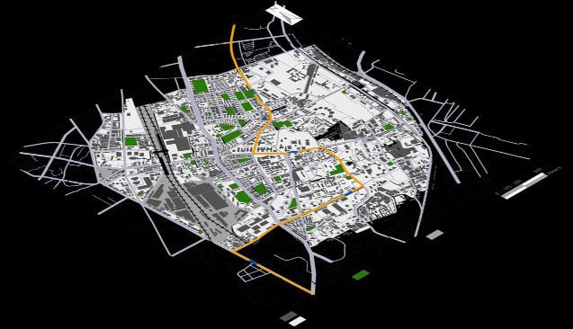
LOCAL AREA PLAN, PAREL- SEWRI MUMBAI
Area development model case study

INTRODUCTION


Mumbai is the densely populated financial capital of the country & a prime example of urban transformation. Mumbai’s urban extents go up to all MMRDA
The limited land to expand and high demand for development have led to an intense growth of the city. Mumbai also boasts of some of the major infrastructure projects in the country.
Looking at the site, All the suburban lines Western Central and harbor through the site with a metro proposed and monorail already functioning. A trans harbour link is set to connect the area to Navi Mumbai.
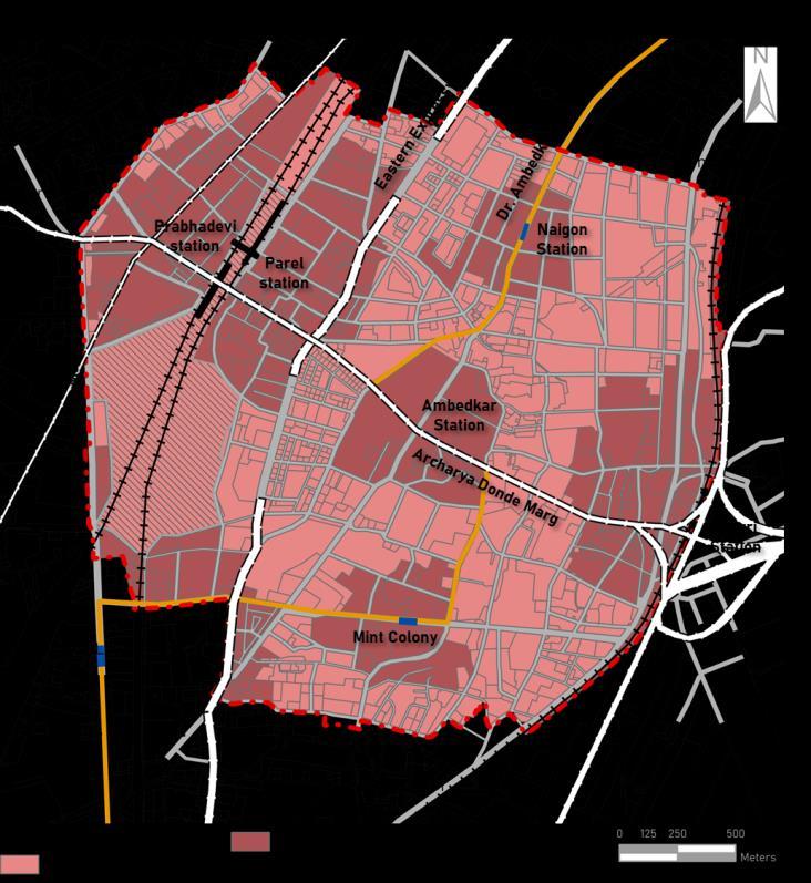
Transit Stops of suburban railways, i e , Prabhadevi Station, Parel Station, and Sewri Station are present with 3 monorail stations Naigaon, Ambedkar Nagar, and Mint Colony.


Total Area MMRDA 6000 ������
Western Central Harbor
Western Expressway Eastern Expressway Eastern Freeway
Mumbai Coastal Road
Trans- Harbor

Total Area MCGM 415 ������

Page 04
MUMBAI
LOCAL AREA PLAN FOR PAREL- SEWRI,
Parel Sewri
HISTORY & PAST PLANNING EFFORTS WITH ONGOING & FUTURE PROJECTS

Looking at the history of Parel Sewri in a larger context of the city’s evolution, it has been always an important area that has been influenced by Cotton mills established in West Parel but the DP did not include mill lands which led to their lack of transformation which happened to the construction of massive infrastructure projects.


Page 05
EXPANSION
REGENERATION
URBAN
AND
PLANNING STUDIO


Page 06 LOCAL AREA PLAN FOR PAREL SEWRI, MUMBAI 1. Mumbai Port Trust 2. Worli Sea-Link Connector 3. Trans Harbor Link 4. Proposed Metro Line 6. Parel Terminus
EXISTING SITUATION ANALYSIS

ROAD NETWORK
There are missing links, dead ends & lack of east-west connectivity.
Road Hierarchy one of the issues identified was the jumps from local roads to arterials and highways which leads to congestion. There’s an uneven distribution of the road network as per the block area The Parel station and workshop, defunct textile mills add larger blocks in the study area.


WALKABILITY


CNR: 0.75 LNR: 0.7


LAND USE
Residential Use is the predominant land use of the area followed by transport and Industrial.
BUILT VS OPEN
Analyzing the relationship between built and open. 55% of the area is privately open out of which 30% is under setbacks. The area under transport is high due to highways and land under railways.
Page 07 URBAN EXPANSION AND REGENERATION PLANNING STUDIO
BUILT USE & TYPOLOGY
The built form consists primarily residential use In the residences, the major typology is apartments followed by chawls and slums


BUILT AGE VS TYPOLOGY
In building morphology, 90% of the structures were built before 2005 the ages of these buildings vary from 17 to 60 years old. After that, defunct mills were demolished. Mill land redevelopments started happening Apartment buildings started coming up.
FLOOR AREA RATIO


Mean/ Max. FAR : 1.93 / 14
The average FAR in the area is 1.93 which is going as high as 13 in some cases on major arterial roads. The land consumption in transit buffers indicates suboptimal use of land

MARKET RATES
The market rates are as high as 2 8 times the Jantri Rates Even though the market price is just 2.8 times the Jantri Rates is itself high.
Page 08 LOCAL AREA PLAN FOR PAREL- SEWRI, MUMBAI
30 30 22 21 18 4 Current PIR of income groups at Mean FSI


Page 09 URBAN EXPANSION AND REGENERATION PLANNING STUDIO KEY TAKEAWAYS Lack of Road Connectivity & Walkability Poor Interface Congestion on Streets & Junctions Lack Of Infrastructure Unaffordable Housing Scenario Informal Activities on Streets Private Open Spaces due to high Setbacks Centrality of the Site High demand for development Existing Transport Infrastructure High demand for redevelopment
SCENARIO BUILDING
Owing to the influence of Lower Parel, Parel turns into a commercial hub catering to Lower Parel’s spillover.
Parel morphs into a mix of Dadar Wadala and Lower Parel with a mix of residential and commercial use.
With MbPT, Uran in proximity the area develops as residential mix use with three regional level roads.

VISION & OBJECTIVES
Transforming Parel Sewri into a Transit oriented mix use neighborhood that is inclusive & affordable in nature, accessible and intense in form, complimented by an integrated network while being responsive to the market demand


• Integrate Road Network with complimentary activities & Multi-Modal connections.

• Encouraging & Guiding intensity towards transit stops
•


• Improving affordability & equity in the housing market.
• Present a model of urban transformation through the
• LAP mechanism in Mumbai.
Page 10 LOCAL AREA PLAN FOR PAREL- SEWRI, MUMBAI
street
To achieve a built form that enhances walkability and
experience
Intercity/ Intracity link b/w East-West. Infrastructure & Open spaces Accessibility Intensity Integration CONCEPTUALISATION Walkability The link b/w North South Connections Land/ floor space Activities/ Land use Hierarchy
PROPOSED ROAD NETWORK
Objectives 1: Integrate Road Network with complimentary activities & Multi-Modal connections.

Using Road network to increase green % per person and connecting these Public open greens.


Proposed Road Network
0.7 ������
AREA UNDER PROPOSED ROADS
Retained Road Network To improve the walkability along the roads which are close to public transport stations, urban green infrastructure is proposed to integrate all public green spaces RIGHT OF WAY (%

change)
4 20 4 28 44 E P WALKABILITY (% change) BLOCK SIZES (% change)

ROAD HIERARCHY (% change) E P 14 20 38 28 38 34 22 6 E P

22 45 33 27 49 24 Page 11 URBAN EXPANSION AND REGENERATION PLANNING STUDIO
AREA UNDER EXISTING ROADS 14 47 28 11 8 51 29 11 4 17 25 54
0.5 ������ E P
PROPOSED ZONING

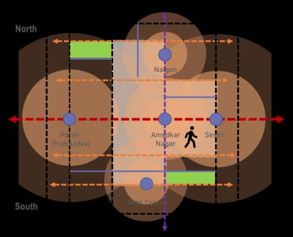
Objective 2: Guiding intensity & complimentary activities towards transit stops
Catchment area of transit stops, of 500 m & 200 m for 5 min buffers.


Catchment area of transit stops, of 400 m & 1000m for 10 min buffers. The existing regulations for FSI are based on the abutting road widths for a plot With higher RoW’s, higher levels of FSI can be consumed with a minimum of 1.33 base FSI, which is free. Comparing the existing and proposed regulations, high intensity development can be achieved through zoning.
Key difference in zones?
Maximum height of Right of Way availed on plots over 18 m RoW when 10 % affordable housing is provided in MU 1 zone & 20% in MU 2 Zone.
Page 12 LOCAL AREA PLAN FOR PAREL- SEWRI, MUMBAI
PROPOSED REGULATIONS
EXCLUSIVE PLOTS
PROPOSED HEIGHT
Maximum height is RoW times six on roads above 18m .


Permissible Height in current regulations is 3 times the Right of Way


Conditional Height in Proposed regulations is 6 times the Right of Way when inclusive housing is provided.
PROPOSED STEPBACK

• Activities on the Ground Floor Public open spaces, retail shops, etc
• Certain built form regulations have been incentivized and mandated on exclusive plots, plots lying on major arterial and sub-arterial roads
• To overcome the issues created with taller structures step backs have been mandated, with a minimum stepback of 6m to be provided when a height of half times ROW is achieved.
Page 13 URBAN EXPANSION AND REGENERATION PLANNING STUDIO
Height of Building Achieved Step back RoW * 1/2 Built to Line Height > RoW* 1/2 6m
PROPOSED REGULATIONS
COMMON OPEN SPACES PROPOSED SETBACKS
Private Open Space Percent
Area smaller than 1000 sq.m 10% (no ratio maintained)
Area from 1001sq.m to 2500 15%
Area from 2501sq.m to 10000 sq.m 20%
Area from 10000 sq.m 25%
Public Open spaces have been aligned towards roads abutting the plot with Length to Width Ratios specified.
PROPOSED PARKING REGULATION
• Parking above maximum Parking to be monetized @ 100% RRR.
• The existing parking mandated minimum parking while the proposed parking allows a maximum parking limitation varying according to the size of the tenement. Parking above allowed parking is purchasable at Ready Reckoner Rate.
• The intent is to disincentivize parking in areas with access to public transit
• Front setbacks vary proportionally with the RoW and built to line is mandated on all roads.


• Side setbacks depend on the height achieved by the building and the size of the plot.
Side and Rear Setbacks


Plot
Height

Up to 32m
3.6-4.5 3.6-4.5 32- 70 m h/5 or 12m h/4 or 12m 70- 120 m h/4 or 13m 120m and more h/4 or 14m
Page 14 LOCAL AREA PLAN FOR PAREL- SEWRI, MUMBAI
of building
smaller than 1000 sq. m Plots larger than 1000 sq. m


Page 15 URBAN EXPANSION AND REGENERATION PLANNING STUDIO MASTER PLAN WITH ALL IDENTIFIED PROJECTS 9 1 3 8 7 2 6 5 Flood resilience Redevelopment around Naigon Station Junction Redesign Development of Parel Terminus Dev. of Ambedkar station Multi-Modal
Sewri Station Dev. of Mint colony station Redevelopment of TataMills through station area planning Junction Improvement
Integration at
PROPOSAL 1: REDEVELOPMENT OF MILL LAND WITH STATION AREA PLANNING
The Station Area of Prabhadevi with defunct mill lands adjacent to it, faces issues like narrow approach roads, poor entry exit points, stations lacking space for NMT and pedestrians, etc.
Station Road
Proposed Feeder Road


Proposed Public Plaza

To increase the accessibility of the station, reentry exit points and foot over bridges have been introduced and improved. To increase the walkability and ease of access to the station.
With the redevelopment of the adjacent Tata Mills, the mandated open green space under mill land redevelopment regulations has been aligned with the transit stop.
Page 16 LOCAL AREA PLAN FOR PAREL- SEWRI, MUMBAI
PROPOSAL 2:
MULTI MODAL INTEGRATION AT SEWRI STATION
Sewri Local Station with a nearby proposed metro station & an existing bus stand. The major road, Acharya Donde Marg is abruptly stopping at a dead end due to level differences, thus hindering the connectivity of the site. Also, the foot-over bridge is not taking people up to the station area.
The Road network is completed by continuing Acharya Donde marg with an optimum slope of 1 by 12.


`
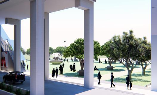
public open spaces have been identified near the stations and the bus stand for people to relax amidst traveling.
the foot over bridge has been extended to the station area.
the proposed metro station will also be connected to the local station through a subway.


Page 17 URBAN EXPANSION AND REGENERATION PLANNING STUDIO
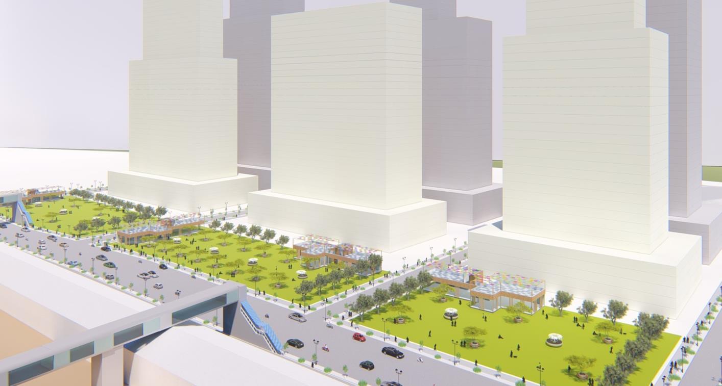
PROPOSAL 3: REDEVELOPMENT OF NAIGON STATION


The road has been widened and block sizes are reduced through the feeder road.
The public open space, adjacent to the station, has been integrated with the entry of the station with Foot Over Bridges.
Page 18 LOCAL AREA PLAN FOR PAREL- SEWRI, MUMBAI
Road Widening, Improved Connectivity & Reduced Block Sizes Wider ROWs
Public Open Space Integration with Adjacent Land Uses
•
• Both the plots in the existing situation cover 80% of the ground coverage.


• Road widening on both the roads adjoining.
• Consideration is to identify Cessed building & the second consideration is to identify those cessed building that is in dilapidated condition.
• It is assumed that whenever these plots
they will develop together and owners are willing to amalgamate the two identified plots.
Page 19 URBAN EXPANSION AND REGENERATION PLANNING STUDIO
AREA STATEMENT SR.N O AREA STATEMENT REGULATION DETAILS SQ.M 1 Gross Area under Plot 3022 2 Deduction in road widening Section 16 205 3 Balance area of plot available for development 2817 4 deduction after LOS Section 27 10% minimum of plot area i.e. 281.7 2535.3 4 Base FSI Part V of DCR Current FSI = 3.22 FSI 3 or 60 % of FSI required for rehab. To existing Occupier (3.22 + 1.93) 13057 5 admissible TDR FSI= 0.34 957.78 6 baSE FSI + admissible TDR 14015 7 BUA due to additional FSI on payment of premium Part V of DCR FSI= 0.33 836.649 8 Total permissible BUA 14851.2 DEVELOPMENT FEASIBILITY STUDY: PLANNING FEASIBILITY
redevelop,
ZONING AS PER DP 2034 EXISTING LAND-USE
Built
typology: Chawls
• No of plots: 2
• No of Floors G+3
• Plot area 1: 1,677 sq.m
3 22 Land development as per Existing regulations Permissible uses that are possible plot All type of residential Commercial Retail Commercial Non retail Mix use Development Small scale Institution
• Plot Area 2: 1,345 sq. m • Consumed FSI:
STUDY:
MARKET FEASIBILITY


• The predominant plot use in the area is residential. • The prevalent re-development trends indicate a greater demand for high-rise high-density luxury residential development. Scenario: Mix-use (residential (80%) + Commercial (20%))


Consideration of this Scenario • Need to give residential use to rehabilitate the same number of tenements at least according to regulations 33. • Providing existing commercial at least. according to regulations 33.
TDR calculation: Permissible BUA + Available TDR (FSI to be purchased @ 60% of ready reckoner rate) (TDR to be purchased @ 5000 per sqft) = 102.4 cr.
Potential Profit: Total Area + Parking + cost of Construction + cost of TDR + dev. Charge = 181 cr.
In The Business-as-usual case the developer will have a profit of 181 2 Cr
If the developer builds more commercial, then it is more profitable
Non-Sale Able Component Sale-Able Component Page 20 LOCAL AREA PLAN FOR PAREL- SEWRI, MUMBAI
•
coming
UNITS'
AGE OF CONSTRUCTION IN PAREL COST OF DEVELOPMENT Rate (in sq.m) Amount Amount (in cr.) Residential BUA 11881.0 33637.5 39.96 Cr. 55.1 Cr. Commercial BUA 2970.24 34983 10.39 Cr. parking 2554.70 18514.08 4,72 Cr. Total BUA 17405.9 55.08 Cr.
After analyzing the local market, it is observed that 30% of people live in 1 BHK but those buildings were constructed 20 years back. • The recent development trend represents more 2BHK and 3 BHK apartment buildings
up. DWELLING
OCCUPANCY
DEVELOPMENT FEASIBILITY
•
•
•
COMPENSATION MECHANISM WITH LAND IMPACT ASSESSMENT
The compensation mechanism considers two components one for Land Lost and the development potential compensation.
CASE I: THE PLOT IS DEVELOPABLE AFTER DEDUCTION
The first case of a plot remaining developable after deduction the total compensation for on this plot will be 1.5 times of the total development potential lost. In case of plot 792

CASE II : THE PLOT IS UNDEVELOPABLE AFTER THE DEDUCTION


In the second case of a plot being undevelopable after deduction the total compensation for this plot will be 2 5 times the total development potential lost In the case of plot 873
CASE III: THE PLOT IS DIVIDED INTO TWO SUBPLOTS
In the third case where plots are divided into subplots, the compensation calculated is the same as discussed in the previous cases depending on whether the subdivided plots are developable or undevelopable
Page 21 URBAN EXPANSION AND REGENERATION PLANNING STUDIO


Page 22 LOCAL AREA PLAN FOR PAREL- SEWRI, MUMBAI LAND AUDIT Total No. of Existing Plots - 1046 Total No. of Revised Plots 1079 No.
Plot
Accounting for all the land taken from the private realm to the public and the compensation
Land Consumption Existing Proposed % of total % Change TDR Generated as compensation Roads 0.4 0.7 40% 45,201,23 sq. m Amenities & Reservations 0.4 1.2 55% 5,90,212 sq. m Railways 0.4 0.4 0% Land in Private 5.1 4.4 8.3% Total Area under LAP 6.02 6.02 51,103,35 sq.m With
the proposals implemented DCRs
51
Built Out Scenario Built-up area (����2) Estimated Population (Lakhs) Existing 100% Built out 76,12,132 1.7 Scenario 1 Commercial Residential 75% built out 10.5 6.3 4.2 4.6 100% Built out 14.0 8.4 5.6 6.1 Scenario 2 75% built out 10.5 7.3 3.1 4.2 100% Built out 14.0 9.8 4.2 5.2 Scenario 3 75% built out 10.5 5.7 4.7 4.8 100% Built out 14.0 7.7 6.3 5.6 SCENARIO-WISE POPULATION PROJECTION To estimate the population, increase
the LAP is implemented three scenarios with
uses have
infrastructure demand is planned
the
development
the zoning and regulations.
of Affected
827
TDR generated.
all
worth
Lakh sq. m of Built Up will be issued. The area under roads has increased by 40% and 55% under amenities and reservations.
after
different built
been considered The highest
for given
intense
encouraged through


Page 23 URBAN EXPANSION AND REGENERATION PLANNING STUDIO ~36 MLD Existing Demand/Generation Scenario 1 Scenario 2 Scenario 3 100% Scenarios Waste Water Generated (In Million Litres/Day) ~29 MLD Solid Waste Generated (In
~215 MTD 92 MLD 73 MLD 366 MTD 78 MLD 62 MLD 312 MTD 84 MLD 67 MLD 336 MTD Water Demand (In Million Litres/Day)
REQUIREMENT
PLAN Build up Percent
Metric Tonne/Day)
INFRASTRUCTURE
PHASING OF LOCAL AREA
REVENUE GENERATION KEY LEARNINGS


Total Cost: 2570 Crores
Total Revenue Generated: 8699 Crores
• The total cost of the project is around 2500 crores out of which 1300 crores will be borne by MCGM. The laying of new roads and increasing the water supply infrastructure are the most-heavy components of the LAP.
• The LAP self financing as the infra fee is covered by MCGMs internal funds by TDR and Premium FSI Sale

✓ Identifying Market demand through development feasibility along with planning feasibility of a plot.
✓ Understanding the value through Land Impact Assessment of every single plot and repercussions of proposed DCR and zoning.

✓ To understand Market demand in Mumbai through the TDR mechanism and how some zoning and regulations don’t work in other Indian cities but are very much applicable in Mumbai like the TDR market
✓ Understanding different development models like Land pooling, and land readjustment along with its statutory framework, implementation mechanism, and spatial planning parameters with financial& revenue models

✓ Importance of micro-level plans to develop certain areas in a specific urban form and guiding development & spatial planning on higher-order plans
✓ Focused on developing core competencies in preparing micro level plans for brownfield (LAP) areas that go beyond conventional approaches and integrate multi-disciplinary aspects resulting in a high-quality environment.
Page 24 LOCAL AREA PLAN FOR PAREL- SEWRI, MUMBAI
Planning Urban Expansion
Regeneration Planning Studio Monsoon-2022 CEPT University
Master of Urban
And
