
Weitzman School of Design CPLN703 Planning Studio
REfshaleøen REgenerate,
REtain, REimagine
Copenhagen, Denmark

January 16, 2025
Instructor: Gregory Haley
Team: Vanessa Diaz, Khulan Enkhold
Elaina Geiger, Ziyi Guo, Yuan Ji, Jia Yang Kwok, Xinya Liu, Caroline Lu, Isabel Mulay, Regy Septian, Xiaxin Tang, Ashley Zuo


REfshaleøen
REgenerate REtain REimagine
Following the closure of the shipyard, Refshaleøen has been controlled by Ejendomsselskabet Refshaleøen A/S, a property management entity representing four pension funds, and By & Havn (CPH City & Port).
Refshaleøen Today
Today the unique landscape of Refshaleøen, dotted with abandoned industrial structures and former docks has embarked on a new post-industrial life. The old shipyards are now home for a range of creative, cultural and entertainment uses including Copenhagen Contemporary, and a host of restaurants and cafes while its large open spaces host a range musical festivals and other events throughout the year. Additionally, Refshaleøen is the home to a large water treatment plant, which cleans a significant part of greater Copenhagen's wastewater.
In 2009, the City of Copenhagen's municipal plan designated Refshaleøen as a prospective area for future urban development to address some of the housing pressures facing the city. Environmental studies have assumed a potential development capacity of up to 1.1 m. sq. meters within the approximately 80-hectare area. This has led to the recent open-call ideas competition for Refshaleøen and the short-listing for a future, more indepth, design and planning competition to be undertaken in 2025, and administered by Ejendomsselskabet Refshaleøen.
Lynetteholm
Studio Premise
Planning for the Future of a Historic Waterfront
The twelve students who undertook the challenges of this studio engaged with the complexities of Refshaleøen, in Copenhagen. Among other aspects, they considered: The historic development of Refshaleøen, and its relation to the growth of the broader city of Copenhagen; Its environmental conditions and vulnerability to climate change; The current social and cultural life of the district, including the types of uses and activities it hosts, and its evolving character; The role the area plays in the social and economic life of Copenhagen's residents, visitors, and tourists; As well as the range of existing plans and ongoing debates about its future (including considerations for the future of the wasterwater plant on site, transit infrastructure, and the proposal for the Lynetteholm extension into the harbor).
Based upon this analysis the students developed proposals for the future transformation of the peninsula that grapple with the social, cultural, environmental, and physically constructed aspects of this unique urban context, and seek to strategically respond to the City's current housing development pressures while preserving aspects of Refshaleøen's unique sense of place.
Planning Context
Situated north of Copenhagen, where the harbor meets the sea, Refshaleøen began as the island of Lynetten which served as part of the City’s coastal defence. Over decades of successive landfill, it was connected to the island of Amager, appearing today as a peninsula. Following harbor dredging it became attractive as a port and in 1871 it become home to the Burmeister and Wain shipyard. It remained in operation there for over 100 years and at its height was one of Denmark’s largest employers.
Adjacent to Refshaleøen the Municipality of Copenhagen has also approved and begun work in 2021 on an approximately 275-hectare land reclamation project called Lynetteholm. This new landmass, will essentially be an extension of Refshaleøen and act in part as coastal defence against storm surge and sea level rise. The potential for this land-filled area to support residential development for an additional 15,000 people is also being considered. In addition, there are preliminary, but not yet confirmed plans to extend metro service through Refshaleøen to Lynetteholm.


Burmeister & Wain A/S shipyard Configuration
Wastewater Treatment Plant
Wastewater treatment plant
Reffen Food Market
"Copenhell" Concert
Lynetteholm, City of Copenhagen
Studio Process

Studio Approach & Methodology
The studio process was organized into 3 parts: Discovery and Analysis, Frameworks, and Project Exploration:
Part 1: Discovery - Data Gathering/Research/Analysis
During this initial phase, students worked in groups to:
• Assemble background site & historical information
• Review past and current plans, and relevant policies
• Research and analyse relevant waterfront redevelopment case studies
• Analyse findings and prepare a written and graphic summary for the studio reference
The analysis was organized around 3 system “lenses”:
• Constructed Systems (urban form, infrastructure, etc.)
• Natural Systems (ecology & environmental conditions)
• Social Systems (historical, econ.. & cultural aspects)
Part 2: Emerging Framework Development
Following initial research and analysis, the students worked in groups to develop various planning system strategies and then synthesize these into a composite framework plan approach which will serve as a general basis for further planning and design development throughout the semester.
This effort will task the studio groups to define:
• Key project goals/objectives & drivers/priorities
• Key planning strategies
• An initial high-level development framework plan
Part 3: Project Identification & Concept Visioning
Following the development of a planning framework and building off findings from Part 1, the students , working in groups of 2 or 3, identified key questions or issues to be explored and further developed within a particular geographic portion of their framework plan.


Studio Work plan
Learning from Copenhagen, & Malmö

Studio Study Trip, October, 2024
As part of the studio we embarked on a study trip to Copenhagen and Malmö, touring historic places and recent developments, learning from local public-sector city planning officials, architects, landscape architects, engineers and urban planners, as well as representatives from the Refshaleøen property management company.
Special thanks to all of the following individuals for sharing their time and insights with our studio:
In Copenhagen
Frederik Ellegaard Haukrogh & Tue Rex, City of Copenhagen; Louise Panum Baastrup, Refshaleøens Ejendomsselskab; Jacob Deichmann, Ramboll;
Mads Birgens, Cobe; Bjørn Ginman & Nicoline Madsen, SLA; Sofia Lundeholm, Mateusz Mastalski & Jesse
Paul Stanford, Henning Larsen; and Tobias Steen, Buro Happold.
In Malmö
Lotta Hansson, City of Malmö.
Philadelphia and Online
Steven Baumgartner, BUSS; Julia Day, Gehl; Emory Lee Ramboll; Santiago Orbea, Henning Larsen; Tali Cantor, Union Square Partnership; Elizabeth Kennedy, EKLA; Nando Micale LRK & Univ. of Pennsylvania; and Xiaoxia (Summer) Dong, Akira Drake Rodriguez & Michael Fichman, Univ. of Pennsylvania.


in
Benefiting from the perspective of Tue & Frederik at Copenhagen City Hall
Learning about human scale on the waterfront with Lotta from the City of Malmö
Benchmarking with Jacob of Ramboll in Nordhavn
Cycling through the heart of the City
Immersing ourselves
CityNature at Sankt Kjelds Plads with Bjørn from SLA
Learning from Copenhagen's iconic public space
Touring Refshaleøen with Louise from Ejendomsselskabet Refshaleøen A/S,
Learning about the integration of old and new in the Carlsberg district
Visiting ØsterGro, a rooftop Farm in Copenhagen

Stage I Discovery & Analysis
REfshaleøen: REgenerate, REtain, REimagine
REfshaleøen
REgenerate, REtain, REimagine
01 Social
From a rich industrial past to a vibrant hub for events and cultural gatherings today.


Vanessa Diaz
Jia Yang Kwok
Joey Tang
Ashley Zuo
REfshaleøen
REgenerate, REtain, REimagine
REfshaleøen: REgenerate, REtain, REimagine
History
To better understand Refshaleøen and its character today, it is important to understand its history. The City of Copenhagen was founded in 1167, when it started as a castle named Castle Islet on an island named Slotsholmen. In 1445, Copenhagen became recognized as the capital of Denmark. Due to attacks from neighboring countries, a
sea fort was built north of Amager on an artificial island named Lynetten in 1766. This formed a defense around Copenhagen. In the 1870s, Copenhagen began infilling more of the harbor around Lynetten, forming what is now known as Refshaleøen. Burmeister and Wain (B&W), a shipbuilding company, set up their operations on this
new land. The B&W shipyard quickly became one of the largest in the country, with over 10,000 employees. However, by the 1970s, B&W faced financial hardships, eventually going bankrupt in 1996. Refshaleøen was officially opened and accessible to the public in 2009 and became a cultural and artistic hub to many. Due to climate
change and increasing extreme weather events, the city has decided to continue their tradition of infill to create a new artifical peninsula in the harbor. This development is named Lynetteholm and is attached to Refshaleøen. The city hopes Lynetteholm will defend Copenhagen from northern storm surges.

REfshaleøen: REgenerate, REtain, REimagine
Demographics
Refshaleøen and Lynetteholm Today
Refshaleøen Ejendomsselskab A/S, the real estate development company and landlord of Refshaleøen, is dedicated to the growth and future development of Refshaleøen. In an effort to continue developing Refshaleøen, Refshaleøens Ejendomsselskab and Copenhagen By & Havn launched an idea comeptition for Refshaleøen during the summer of 2023. This competition was designed to encourage organizations and competitors to put together a structural plan and a master plan for Refshaleøen.
The competition was centered around five themes. The first theme was to further the development of Refshaleøen’s creative environment. The second theme was based on the transformation of buildings in Refshaleøen. The third theme was the development
of biodiversity and urban nature in Refshaleøen. The fourth theme was the development of Refshaleøen as a mixed district. Finally, the fifth theme was left as an open category for the teams. There were 23 idea proposals that were awarded prize amounts, which will all contribute to a local plan for Refshaleøen.
While planning for the future of Refshaleøen is continuously being worked on, progress towards the development of Lynetteholm has been made. The construction of Lynetteholm began in 2022. The construction period was set to be two phases. The first phase is the construction of rock dams filled with soil adjacent to Refshaleøen, which was expected to be completed in early 2023. Phase two is the construction of the rock dams in a larger area, which is projected to be completed in early 2026.

This site analysis focused on collecting demographic data on a small scale, neighborhood level. This analysis will focus specifically on the Holmen and Refshaleøen neighborhood, which is to the northeast of the Greater Copenhagen region.
Population
Refshaleøen experienced notable population growth from 2014 to 2024. It grew by 83 percent throughout this decade. The 2060 population projection for Refshaleøen reflects positive continuous growth. This presents an opportunity to develop Refshaleøen into a desirable location to live, work, and play, considering it will be a hot spot.
Neighborhoods across Copenhagen reflect significant variation in terms of their population distribution. The Nordvest neighborhood has the highest population density with a toal of 32,127 inhabitants. This is an indicator of Nordvest being a neighborhood with a high concentration of residential zones. When analyzing the population distribution across Copenhagen, it appears that central and northern regions of the city are more densely populated. These are areas that are in closer proximity to employment opportunities, public transportation, and other amenities.


Age Structure
The age structure in Refshaleøen is comparable to the City of Copenhagen because it consists of a larger proportion of individuals 65 and older. Additionally, Refshaleøen has a 4 percent lower proportion of young adults in the 25 to 34 age group. This indicates that Refshaleøen may be a more desirable location for older individuals, such as people who have retired and are looking to live in a peaceful area that does not have as much constant activity.

Citizenship
An analysis of citizenship in Copenhagen found that neighborhoods located near the city center are primarily made up of Danish citizens. This may attributed to the accessible jobs and amenities within the area. Southern neighborhoods, such as Holmene and Syd tend to be made up of Western country citizens. This points to a preference of suburban and modern developments. Tingbjerg and Nord, western parts of Copenhagen, are made up of non-Western country citizens. These are areas further from the city center which indicate socio-economic disparities or limited housing options. This spatial segregation underscores the need for the implementation of inclusive urban policies that will help foster integration and equitable access to resources. Around 83 percent of Refshaleøen’s residents are Danish citizens. Residents from Western counries make up around 13 percent, while 4 percent are from non-Western countries. This analysis of citizenship in Copenhagen highlights that citizenship is more diverse in greater Copenhagen than in Refshaleøen.


Households
At the household level, Refshaleøen has a 15 percent higher proportion of married couples and registered partnerships. There is a 6 percent lower proportion of single men and women in Refshaleøen in comparison to Copenhagen. Along with this, Refshaleøen has an average family size of 2.35, which is 0.4 higher than Copenhagen in 2024. This indicates that there is a greater sense of a familial structure with two parent figures or significant others in Refshaleøen.

Income Distribution
When examining the income distribution in Copenhagen, it reveals that higher-income neighborhoods are concentrated in urban and eastern areas of the city. Areas such as Bryggen Syd and Gammelholm and Nyhavn reflect the highest earning income levels, which may be attributed to their proximity to central business districts and various amenities. Bryggen Syd’s average income is 722,078 DKK while Gammelholm and Nyhavn’s is 664,859
DKK. Tingbjerg, a neighborhood with an average income of 251,876 DKK, reflects lower income levels, signaling socio-economic disparities. There is need for policies that address housing affordability and income disparities in the city.
In comparison to Copenhagen, Refshaleøen has a 70 percent higher average income per person. This income gap has existed since 2017. While pressures of unaffordability in Copenhagen arise, it appears that higher earners are residing in areas like Refshaleøen.


Housing
Housing is largely concentrated in the northern and central southern regions of Copenhagen. The Nordvest neighborhood consists of the highest proportion of housing dwellings, with a total of 18,224, while Refshaleøen has 1,514. In 2024, Refshaleøen was predominantly made up of multi-dwelling houses - around 83 percent. Across Copenhagen, the housing price distribution presents significant disparities. Central areas, such as Indre By, have the highest prices due to their proximity to jobs, amenities, and public transport. Peripheral areas, such as Vanløse offer more affordable housing options. This pattern identifies socio-economic segregation in which lower-income residents are pushed to the outskirts of Copenhagen, thereby relying on longer commutes. Planners should address these challenges through mixed-income housing, enhanced public transit to improve connectivity, and investments in infrastructure and amenities for outer neighborhood access.
There was a sharp rise in condominium prices from 2014 to 2024, with an increase of 73 percent in average housing prices. The average condominium price in Copenhagen K is 121 percent higher than in Copenhagen, which highlights significant geographic disparities. This disparity underscores the growing demand for housing as the population continues to grow. In addition to this, from 2014 to 2024 there was a three time increase in private rental houses, with a roughly 2.3 times increase of owneroccupied housing.
This examination of housing in Copenhagen and Refshaleøen has led to the conclusion that current and future demographic changes are largely driven by international and national migration. Newcomers from outside countries are attracted to Copenhagen’s job supply, educational opportunities, quality of life, and livability. Despite this, Copenhagen lacks small homes that are less than 60 square meters. The development of smaller homes will not only be more affordable, but will potentially take less time to develop and accommodate the growing population. To stabilize housing prices, the housing supply will need to increase by 56,000 homes by the year 2030.


Land Use & Zoning
The Copenhagen Municipal Plan for 2019 to 2031 outlines a comprehensive framework for the city's land use and zoning policies. The primary focus of the plan is to balance development while addressing housing, services, institutions, and leisure purposes. This approach ensures that the city's infrastructure supports a harmonious urban environment that caters to both residential and commercial needs. The plan serves as a guiding document for municipal decision-making. While the plan does not impose direct legal obligations on property owners, it provides a critical framework for the municipality to adopt its policies and urban development strategies. This ensures that any development aligns with the long-term vision for the city while safeguarding community interests and promoting sustainable growth.
Commercial areas in Copenhagen largely overlap the Finger Plan and major transportation routes. The retail framework is organized into the following categories: the city centre, district centre, local centre, and stand-alone shops. The overlapping distribution of retail zones with major transportation routes ensures seamless connectivity. This design supports a sustainable urban environment by reducing travel distances and enhancing the quality of life for residents and visitors.
Refshaleøen exemplifies a dynamic mix of modern creativity, commercial activities, and industrial heritage. This site demonstrates a strategic approach to urban landuse, blending industrial legacies with emerging cultural and commercial functions.
• West Side Dynamics: The central-western part of Refshaleøen is more vibrant, hosting major commercial enterprises and small businesses. This reflects the area's proximity to the city center, making it a hub for economic activity and creative innovation.
• Industrial Heritage in the East: The eastern part is more influenced by its industrial past, with significant infrastructure and industrial facilities still dominating the landscape. This juxtaposition creates an intriguing spatial and functional contrast within Refshaleøen.
Copenhagen’s evolving urban landscape includes designated creative zones that balance innovation with heritage. Refshaleøen stands out as a significant potential creative area, offering unique flexibility in development compared to traditional creative zones.


Cultural & Social Life
Samfundssind
A defining concept of Danish culture is Samfundssind, which translates to “community-mindedness.” This embodies Denmark’s strong emphasis on social trust, shared welfare, and collective responsibility. Central to this philosophy is the belief that all citizens are entitled to fundamental welfare benefits and services. For instance, Denmark’s history of housing cooperatives has long provided affordable housing, while the country’s universal welfare model ensures access to unemployment benefits, housing allowances for renters, and state pensions. Despite an average tax rate of 46 percent, Danes widely accept this trade-off as it fosters equity and societal wellbeing.
However, Denmark’s commitment to Samfundssind appears to stand in contrast to its approach to immigration. In recent years, neighborhoods with large immigrant populations have been targeted for demolition and redevelopment, effectively displacing these communities. This raises concerns about equity and inclusion within urban planning processes. As Copenhagen plans for the redevelopment of Refshaleøen, it will be essential to address this tension. A truly equitable approach must account for the needs of both local residents and immigrant populations to prevent deepening social divides and ensure that Samfundssindat its core - reflects an inclusive and collective vision for all members of society.
Hygge (Hogga)
Another key concept that defines Danish culture is Hygge, a term often described as “consciously cozy” or “the art of creating a nice atmosphere.” At its core, Hygge refers to a quality of coziness and conviviality that fosters a sense of contentment and well-being. This typically manifests in small, intimate gatherings where friends and family come together to share meals, play games, or simply enjoy each other’s company in a calm, relaxed setting. These smaller, close-knit gatherings reflect a broader Danish value of prioritizing community and connection—moments of shared happiness that emphasize unity within one’s inner circle. However, while Hygge highlights collective


happiness and social cohesion, it can sometimes feel exclusionary to outsiders. The emphasis on close, established circles of friends and family may make Danish social spaces appear “intimidating and impenetrable” to newcomers, particularly immigrants. This challenge is further exacerbated by spatial divisions within Copenhagen, where immigrants often reside in more affordable suburbs outside the city center, while the most urbanized areas remain predominantly occupied by Danish citizens.
As with Samfundssind, Hygge underscores a cultural value that, while fostering connection, can inadvertently marginalize immigrant communities. In planning for Refshaleøen’s redevelopment, it will be critical to address these dynamics by promoting inclusivity and multiculturalism. Ensuring that Hygge extends to all residents will help bridge social divides and create a truly welcoming, equitable space for Copenhagen’s diverse population.
Art & Design, Music, Museums
A defining feature of Copenhagen is its vibrant focus on arts and culture. The city hosts numerous festivals and cultural events throughout the year, which attract both locals and visitors alike. Copenhagen is also home to world-renowned museums, including the Designmuseum Denmark, further solidifying its status as a cultural hub.
Refshaleøen similarly stands out as an artistic enclave, housing institutions like the Copenhagen Contemporary and hosting events such as the Copenhell music festival. However, unlike Copenhagen’s more established and intentionally cultivated cultural institutions - which have been strategically developed to promote the city as the arts and cultural capital of Northern Europe - artistic activities on Refshaleøen have evolved in a more organic, ground-up, and independent manner. This grassroots character has become a defining feature of the artistic scene at Refshaleøen, contributing to its unique identity within the city.
As Refshaleøen’s redevelopment moves forward, careful consideration must be given to preserving this organic and independent spirit while integrating it thoughtfully into Copenhagen’s broader cultural narrative.


Sustainability-Focused Food
Another defining feature of Copenhagen is its strong focus on sustainability, particularly in relation to food. The Copenhagen Food Strategy 2019 outlines ambitious goals to reduce the city’s carbon footprint by 25% per capita by 2030, with specific targets such as:
• 90% organic food in municipal meals
• Shift toward plant-based, low CO₂ impact meals
• 3 in 4 Danes purchase organic food weekly
Copenhagen is also the birthplace of the New Nordic Cuisine movement, which emphasizes:
• Seasonal cooking and sourcing local ingredients based on the region’s landscape and seasons, reducing reliance on imports
• Reconnecting with agriculture and food history through foraging and the use of wild foods
• Supporting local, organic farms and promoting ethical farming and fishing practices
These sustainability principles are particularly evident in Refshaleøen. For instance, Reffen, the popular street food market, is constructed using recycled materials, embodying a commitment to reuse and sustainability. Additionally, Noma, a world-renowned proponent of New Nordic Cuisine, is located in Refshaleøen and serves as a global leader in sustainable food practices. Beyond its acclaimed dishes, Noma offers educational programs for food practitioners worldwide, aiming to transform hospitality and food systems through sustainable innovation.
Refshaleøen’s integration of these principles highlights its unique role within Copenhagen’s sustainability efforts, blending grassroots initiatives with globally recognized food movements to create a space that is both environmentally responsible and culturally significant.
Key Takeaways
Denmark’s social ideals promote a national identity rooted in shared values that transcend sub-categories such as ethnicity and religion. However, this vision is not without tension, highlighting the challenge of balancing inclusivity with assimilation.
Refshaleøen offers a microcosm of these dynamics. Once an industrial, working-class area, it has undergone significant gentrification, raising questions about who Refshaleøen is for today - and who it can be for in the future. This transformation reflects broader societal challenges of equitable urban development and inclusivity.
Historically, placemaking at Refshaleøen has been organic and grassroots, with creative communities shaping its unique identity. As the City of Copenhagen begins to formalize long-term plans for the area, a critical question arises: Will the city account for and preserve this organic character?
Moreover, the development of Refshaleøen must align with overarching Danish policy objectives, plans, and values. This includes Denmark’s focus on sustainability and cultural identity, while navigating tensions such as gentrification and social integration. Moving forward, careful planning will be essential to ensure that Refshaleøen remains a space that reflects Copenhagen’s values and aspirations, balancing its artistic, grassroots origins with a vision for an equitable and inclusive future.
02 Environment
Environmental conditions, challenges, and strategies for adaptation and mitigation in Copenhagen and Refshaleøen.

Existing Conditions
Geography and Climate
Copenhagen, the capital of Denmark, is located in the Øresund Region, a vital transnational area. The city spans the eastern coast of Zealand, parts of the island of Amager, and numerous natural and artificial islets.
As part of the oceanic climate zone, Copenhagen experiences mild temperatures year-round with moderate precipitation. Average summer temperatures typically range between 15°C and 22°C, while winter temperatures hover between -1°C and 4°C. Rainfall in Copenhagen is relatively evenly distributed across the year, with annual precipitation averaging 600–700 mm. However, the city is not immune to sudden weather shifts, with short but intense rainstorms occasionally causing localized flooding, especially during the summer months.
Copenhagen also faces marked seasonal variations in daylight, which significantly affect its urban and social dynamics. The summer months are characterized by long days, with the sun setting as late as 10:00 PM and rising before 4:00 AM. During the summer solstice, residents enjoy up to 17 hours and 32 minutes of daylight. Conversely, winter days are short and dim, with extended twilight and just 7 hours and 1 minute of sunlight during the winter solstice.
Copenhagen is a low-lying coastal city, with much of its urban fabric situated close to sea level. Refshaleøen is approximately two meters above sea level. About 29% of Copenhagen’s urban land is reclaimed, including Refshaleøen. The city’s land reclamation efforts began as early as the 17th century with fortification projects, where areas like Kastellet were established on reclaimed land to bolster Copenhagen’s defenses. By the 19th century, as industrialization accelerated, larger-scale reclamation projects reshaped the city’s harbor. During the 1870s, dredging initiatives to deepen port waterways resulted in the deposition of excess material to expand landmass. Refshaleøen itself developed during the early 20th century to accommodate the Burmeister & Wain shipyard. Today, Refshaleøen stands as a prominent example of Copenhagen’s historical reliance on reclamation and infill to accommodate growth and shifting land use priorities.


REgenerate, REtain, REimagine
Refshaleøen's elevation.
(Left) Aerial images of Refshaleøen as it was infilled. (Right) Areas of reclaimed land in greater Copenhagen.
Hydrology and Harbor
Historically, Copenhagen’s harbor faced severe pollution due to extensive industrialization, urban wastewater discharge, and port activities. By the mid-20th century, the contamination levels led to a swimming ban as the water became unsuitable for human contact. Industrial waste, including heavy metals and chemicals, combined with untreated sewage, exacerbated the environmental degradation. Until 1995, wastewater frequently overflowed into the harbor through 93 combined sewer overflow channels, contributing to the crisis. Recognizing the urgency, Copenhagen launched an ambitious governmentfunded initiative, allocating 3 billion DKK to address these issues. This effort included rerouting wastewater, constructing overflow barriers, and developing underground retention basins to manage excess water. The first basins were completed in 1998, and by 2002, the harbor had undergone substantial remediation, enabling the opening of the first public harbor baths. Additional cleanup measures targeted historical pollution, such as dredging contaminated sediments and reducing industrial runoff. Today, Copenhagen is internationally recognized for its successful transformation of the harbor, which now supports diverse aquatic life and offers multiple public bathing zones, including two on Refshaleøen. These developments underscore Copenhagen’s role as a global model for urban water management and environmental remediation.
Refshaleøen is surrounded by seawater and features inland wastewater ponds, contributing to its distinct hydrological system. This system includes both natural and human-made elements, shaped significantly by industrial and urban development. Situated at the northern edge of Copenhagen Harbor, Refshaleøen occupies a strategic position in the harbor's complex water network. The Lynetten Wastewater Treatment Plant, located on Refshaleøen, remains central to Copenhagen’s wastewater management. This facility ensures that wastewater is treated effectively before being discharged into the sea, playing a critical role in maintaining the environmental health of the harbor. Following harbor remediation, Refshaleøen’s first harbor bath – Søndre Refshalebassin – was opened in 2018. This is a popular public space in warmer months for residents from around Copenhagen to gather and swim. There are also a multitude of other locations around the site that people informally swim, like outside of La Banchina and near Reffen, the outdoor street food market.


Parks and Open Space
Copenhagen is celebrated for its extensive parks, with approximately 2,260 hectares of publicly accessible green spaces. The city has earned accolades such as the EU’s Green Capital for its innovative urban greening and ecosystem integration efforts. The city’s dedication to green space is underpinned by long-term strategic planning initiatives like the Finger Plan, introduced in 1947, which shaped Copenhagen’s development along five "fingers" of urbanization radiating from the central city. These fingers are interspersed with green wedges, preserving natural landscapes and fostering biodiversity. In its Regional Plan of 2005, the Greater Copenhagen Authority emphasized the future recreational values of this regional green structure. This plan called for the preservation and enhancement of green spaces through municipal planning, ensuring that the green wedges remain integral to the city’s ecosystem.
Open spaces in Copenhagen range from manicured parks to untamed forests, reflecting a diversity of landscapes designed to balance aesthetic, recreational, and ecological functions. The concept of seven experience classes was developed to enhance user experiences within these spaces by addressing distinct sensory and functional attributes. These classes, which emphasize human interaction with nature and the built environment, include: Wilderness
Feeling of the Forest
Panoramic Views, Water, and Scenery
Biodiversity and Landform
Cultural History
Activity and Challenge
Service and Gathering


Copenhagen’s approach to "city nature" emphasizes the integration of ecosystem services into urban design, transforming urban environments into thriving, sustainable ecosystems. As articulated by SLA, a Danish landscape architecture firm:
“City Nature is 100 percent man-made, and which actively uses and utilizes the properties and qualities that are built into nature, in its design. These properties are ecosystem services, metabolism, photosynthesis, etc. And they are both rational, aesthetic and quality of life-creating.”
Refshaleøen exemplifies this philosophy, as it is home to natural growth that has emerged from the industrial remnants.
(Top) Copenhagen's historic harbor in the 1950s. (Bottom) Diagram illustrating combined sewer overflows.
(Top) Island Brygge Harbor Bath. (Bottom) Søndre Refshalebassin in Refshaleøen, near the Urban Rigger floating housing.
(Top) King's Garden, an example of the Cultural History experience class. (Bottom) Superkilen, an example of the Activity and Challenge and Service and Gathering experience classes.
Example of City Nature on Refshaleøen.

Soil Pollution
Refshaleøen's industrial legacy as a shipyard, coupled with subsequent land uses, has left a significant environmental footprint in the form of soil contamination. Much of the site is classified as V2, indicating pollution levels high enough to pose risks to human health and the environment, while other areas are categorized as V1, signifying a potential for contamination due to historical activities. A map of soil drill samples highlights the presence of substances exceeding cut-off criteria in the top half meter of soil. While many of these contaminants are immobile – meaning they remain confined to the soil – some locations exhibit volatile substances, which pose greater risks as they can off-gas into the air or infiltrate groundwater systems. Denmark’s Soil Pollution Act stipulates that the top 0.5 meters of soil must meet strict contamination thresholds for sensitive uses, including housing, playgrounds, and childcare facilities. As such, extensive remediation efforts will be necessary on Refshaleøen before these types of developments can occur, particularly in areas intended for private gardens, leisure institutions, and spaces frequented by children.


On Refshaleøen, green areas cover about 31% of the site, primarily composed of self-grown vegetation. The landscape can be categorized into four main typologies: ruderal vegetation, mixed vegetation, forested, and urban farming. There is one farm on the site, which supports Øens Have, an organic restaurant on Refshaleøen. Given these typologies, there is quite a diversity of pervious and impervious surfaces on the site. Pervious surfaces are important, as they typically allow water to percolate into the ground, rather than run off. Impervious surfaces are usually hotter and less water absorbent.


Map of landscape typologies on Refshaleøen, ranging from wild grown ruderal vegetation to an urban farm.
Map illustrating Refshaleøen's pervious and impervious areas.
Øens Have, the urban farm on Refshaleøen.
Map of boreholes on Refshaleøen, indicating which type of substance was discovered in the soil.
Types of soil contamination; red indicates V2 classification and blue indicates V1contamination.
Energy and Environmental Infrastructure
Denmark is a global leader in renewable energy, with 46% of its energy consumption coming from renewable sources as of 2022 – far surpassing the European Union average of 17.3% and the global average of 14.7%. The country’s energy landscape has undergone a remarkable transition, moving away from traditional fossil fuels like coal and oil toward sustainable alternatives such as wind, solar, and biofuels. While nuclear and hydroelectric power play a minimal role in Denmark’s energy supply, renewables have steadily grown to dominate the energy mix. This shift has been particularly notable in electricity generation, where 81.1% of Denmark’s electricity now comes from renewable sources, a staggering 423% increase since 2000. Wind energy, in particular, has been a cornerstone of Denmark’s renewable energy strategy, surpassing coal as the leading electricity source in 2014.
Wind energy is the backbone of Denmark’s renewable energy sector, contributing 54% of energy generation and 89% of electricity production. This achievement reflects Denmark’s long-term investments in both onshore and offshore wind infrastructure. Offshore wind farms, in particular, play a dominant role, with several located near Copenhagen. Refshaleøen even has a few wind turbines, hosting the Lynetten wind farm on the eastern portion of the site. There are seven 600kW Bonus turbines that generate renewable energy while also serving educational and recreational purposes. Programs that allow visitors to climb the turbines provide a unique opportunity to learn about wind energy practices while enjoying panoramic views of the city. Further east, approximately 3.5 miles offshore, lies the Middelgrunden wind farm, one of the world’s first large-scale offshore wind projects.


In addition to wind energy, biomass has emerged as a critical component of Denmark’s energy strategy, particularly for district heating. Solid biofuels generate 93.5% of Denmark’s heating needs, with facilities like the BIO4 plant in Copenhagen meeting 25% of the city’s heating demand. By leveraging biofuels and reducing reliance on fossil fuels, Denmark has achieved significant reductions in carbon emissions. Over the last two decades, Denmark has reduced its CO2 emissions by 54%, with per capita emissions now standing at 4.42 tCO2 – below the European average of 5.37 tCO2 and significantly lower than the U.S. average of 13.7 tCO2. This success underscores Denmark’s commitment to sustainable energy practices and its role as a global model for decarbonization. The country's renewable energy leadership is the result of decades of policy innovation, public-private partnerships, and technological advancements. By prioritizing wind energy, biofuels, and other renewables, Denmark has created a resilient and low-carbon energy system that supports both environmental and economic goals.

Denmark's C02 emissions per capita between 2000 and 2022.
Cultural Norms
Denmark's cultural norms strongly emphasize environmental sustainability, supported by a proactive government, corporate responsibility, and widespread citizen engagement. The Danish government sets ambitious goals, such as reducing emissions by 70% by 2030 compared to 1990 levels, backed by progressive policies, stringent regulations, and enforcement through penalties and fines. Corporations also play a critical role, with six Danish firms ranked among the top 100 most sustainable corporations globally. This alignment across society has positioned Denmark as a leader in sustainability, ranking first in the 2020 Environmental Performance Index (EPI).
At the heart of these efforts are Danish citizens, whose sustainable behaviors are ingrained in daily life. In Copenhagen, 62% of residents commute by bicycle, significantly reducing carbon emissions. Recycling is another cultural cornerstone, with citizens returning an average of 3.8 million bottles and cans daily through the national system. Such practices underscore Denmark's holistic approach to environmentalism, where the government, businesses, and citizens collaborate to drive meaningful change while maintaining a high quality of life.

Total energy supply in 2022. Graph indicating the evolution of electricity generation in Denmark between 2000 and 2022.
Middelgrunden wind turbines.
Copenhagen residents commuting via bicycle.
Environmental Challenges
Sea Level Rise
Copenhagen faces significant environmental challenges as it grapples with climate change. Among the most pressing issues is sea level rise, which threatens the city’s low-lying areas. For land in Copenhagen to remain safe from flooding, it must be at least 2.5 meters above normal sea level. However, much of the city sits dangerously close to this threshold, particularly areas like Refshaleøen, which average between 0 and 2 meters above sea level. This vulnerability makes the city particularly susceptible to coastal inundation, a risk that continues to grow as global sea levels rise. Compounding this issue is land subsidence. The greater Copenhagen area is sinking at a rate of approximately 0.5 millimeters per year. While the rate may seem small, it is significant when combined with sea level rise, exacerbating the city’s exposure to flooding. Over time, this gradual sinking amplifies the challenges for urban infrastructure, putting additional pressure on Copenhagen’s coastal defenses and stormwater systems.


Storm Surges
For Refshaleøen, the primary environmental challenge stems from storm surges, which are more pressing than cloudbursts. Flooding on Refshaleøen is primarily due to coastal surges driven by storms and rising sea levels. Located on the waterfront with minimal elevation, the site is particularly exposed during storm events, as seawater can easily inundate the land. The city’s 2017 Storm Surge Plan identifies such low-lying coastal areas as being especially at risk, underscoring the need for robust protective measures to prevent significant economic and environmental impacts.
Urban Heat Island Effect


Another major concern for Copenhagen is cloudbursts, or intense, short-duration rainfall events that overwhelm drainage systems and cause significant urban flooding. Today, 0.9% to 1.2% of Danish homes are at risk of flooding, and this number is expected to nearly double by 2071 due to increasingly unpredictable weather patterns. However, cloudbursts pose a relatively smaller threat to Refshaleøen due to the site’s open nature and lower development density. This risk will be amplified as urban development occurs on the site.

The urban heat island (UHI) effect refers to the increased temperatures experienced in urbanized areas compared to their surrounding rural regions, driven by climate change and urban development. This effect occurs when impervious surfaces such as buildings, roofs, and paved areas absorb and retain heat.
While Denmark rarely experiences extreme heat waves–typically remaining below 25–28°C – climate change is intensifying the frequency of warmer weather. Notably, on July 20, 2022, Denmark recorded its highest temperature of 35.9°C. Indirect consequences of the UHI effect include increased public health risks, such as heatstroke and skin cancer, as well as a rise in energy demand. Copenhagen has addressed urban heat through district cooling initiatives managed by HOFOR, which utilize seawater to provide energy-efficient alternatives to traditional air conditioning.
Refshaleøen faces challenges associated with the UHI effect. While parts of the site have natural vegetation that offers shade and cooling benefits, other areas contribute to heat retention due to their paved surfaces and lack of shade. For example, Reffen has significant expanses of impervious surfaces, amplifying heat stress for visitors. As climate change intensifies heat waves and pushes more tourists into Copenhagen to escape extreme summer temperatures elsewhere in Europe, Refshaleøen will need to incorporate additional green spaces to enhance visitor comfort and climate resilience.


Aerial image of Refshaleøen; red indicates areas that will be flooded with 2.5 meters of sea level rise.
2050
Sea level rise scenarios on Refshaleøen in 2050, 2100, and 2150.
The 2011 cloudburst in Copenhagen caused severe flooding.
This image illustrates how low Refshaleøen is relative to the ocean, aplifying its risk from to sea level rise and storm surges.
(Top) Green space on Refshaleøen. (Bottom) Reffen, which has very little shade.
Adaptation and Mitigation
Municipal Plans
Copenhagen Climate Change Adaptation Plan (2011)
This plan addresses the environmental challenges the city faces as a result of climate change and outlines strategies to mitigate and adapt to these issues. With increasing rainfall events, the plan prioritizes the use of Sustainable Urban Drainage Systems (SUDS), including green stormwater infrastructure such as rain gardens, bioswales, and permeable surfaces to manage excess water effectively. To counter the threat of higher sea levels, the plan proposes the establishment of dikes and barrier islands, as well as prioritizing new construction on higher ground to minimize flood risk. To combat the urban heat island effect, the plan calls for increased vegetation and greenery, recognizing their cooling benefits, alongside SUDS to promote evaporative cooling. By integrating these strategies, Copenhagen aims to build resilience against climate impacts while enhancing urban sustainability and livability.
Cloudburst Management Plan (2012)
This plan was developed to help Copenhagen adapt to extreme rainfall events, which are becoming increasingly frequent and intense due to climate change. The plan focuses on updating the city's sewer systems to handle significant rainfall by separating rainwater from wastewater, preventing overflow and contamination. Additionally, underground reservoirs and tunnels are designed to store excess rainwater during cloudbursts, reducing strain on infrastructure. The plan emphasizes the integration of green and blue infrastructure, retrofitting urban areas to capture and channel rainwater away from critical zones. Green spaces, such as parks, are repurposed to double as flood control areas during heavy rain, temporarily holding excess water. Streets are reimagined as temporary waterways that direct rainwater toward lakes, harbors, or parks, with curbs and roads adjusted to facilitate water flow. By combining innovative urban design with nature-based solutions, the Cloudburst Management Plan enhances Copenhagen's resilience to extreme rainfall while creating multifunctional spaces that benefit residents year-round.


Policies
The 2025 Climate Plan sets an ambitious goal for Copenhagen to become carbon neutral by 2025. The plan focuses on reducing energy consumption and transitioning to renewable energy sources. This includes expanding the use of solar cells, wind turbines, and biomass, as well as implementing energy-efficient standards for buildings to minimize emissions. In the transportation sector, Copenhagen prioritizes the development of its bike network to encourage cycling as a sustainable mode of travel. Additionally, the plan calls for new, cleaner fuels for buses and improvements in the energy-efficient operation of the Metro and S-train systems. Copenhagen is currently updating this plan with a vision extending to 2035.
Copenhagen utilizes progressive legislation to achieve its ambitious environmental goals. The Environmental Protection Act (1991) is a cornerstone of Danish environmental law, designed to prevent and combat pollution across air, water, and soil. This act establishes strict discharge standards, comprehensive land planning strategies, and taxes on water supply and wastewater discharges. Under this act, the city's wastewater plan incentivizes sustainable stormwater management, allowing landowners who manage their stormwater on-site – rather than draining it into public sewers – to receive reimbursements of up to 40% of the connection charge.
To further address soil pollution, the Soil Pollution Act (1999) focuses on preventing contamination, safeguarding groundwater, and mitigating negative impacts on public health. This legislation is particularly relevant for sites like Refshaleøen, where industrial history has resulted in soil contamination requiring remediation before redevelopment. Air quality is another priority for Copenhagen, addressed through the implementation of Low Emission Zones. This policy reduces pollution by requiring vehicles to be fitted with particle filters. Copenhagen's energy policies focus on incentivizing carbon reductions using three strategies: thermal energy production, energy-efficient consumption, and transitioning to low-carbon fuels. Measures include taxes on coal, oil, natural gas, and carbon emissions, paired with government subsidies for renewable energy technologies such as heat pumps, solar heating, and wind power.


Enghaveparken, a newly revitalized climate park in Copenhagen, designed to retain stormwater.
Rainwater basin in Copenhagen.
Sustainable Urban Drainage System plan for Sønderboulevard.
CPH 2025 Climate Plan (2012)
Amager Bakke, or Copenhill, a biomass plant in Copenhagen.
HOFOR: Copenhagen's water and power utility who regulates stormwater and helps implement the climate adaptation plan.
Signage indicating a Low Emission Zone.
Case Studies
Østerbro
Østerbro is Copenhagen’s first district fully adapted to climate change, integrating strategies to manage extreme rainfall while enhancing urban life. The district features a network of green streets and pocket parks that serve as retention areas and water basins. Local hills have been reshaped to channel excess water toward designated retention zones. Additionally, public squares are equipped to collect rainwater from surrounding buildings' roofs, utilizing a new pipe system to distribute water locally and reduce strain on the sewer system. One key example is Tåsinge Plads, a public square transformed into a model of climate adaptation. Designed to control and retain rainwater, the square features ‘wild’ urban nature that promotes natural water absorption while providing recreational green space for residents.

Lynetteholm


Lynetteholm is a transformative project in Copenhagen’s harbor, designed to address climate challenges while supporting urban growth. The district will act as a storm surge protection measure, mitigating coastal flooding caused by rising sea levels. Constructed primarily using surplus soil from building projects across Greater Copenhagen, Lynetteholm will create a new coastline with natural woodlands and recreational beaches, fostering habitats for plants and animals and serving as a flexible transition zone to accommodate sea level rise. The initiative will protect Copenhagen from future flood risks while introducing new public spaces and ecological benefits.
The project will also drive urban development in the Østhavnen area, including Refshaleøen, by accommodating up to 25,000 residents and creating 15,000 new jobs. However, its construction will bring challenges, including increased truck traffic and the establishment of a depot for contaminated harbor sludge on Refshaleøen. Transportation infrastructure improvements, such as a shuttle ferry service, a bridge linking Østerbro, and expanded cycling networks, are being explored to connect Lynetteholm with surrounding areas sustainably. Additionally, plans to relocate or upgrade the wastewater treatment plant aim to address population growth and reduce odor concerns.
Lessons and Strategies
Key Takeaways
1. Refshaleøen’s current conditions, plus climate change, place it at risk of flooding due to sea level rise, cloudbursts, and storm surges.
2. Refshaleøen’s slow and uncoordinated development has led to natural rewilding and urban nature.
3. Refshaleøen’s historic industrial context has contributed to significant soil pollution that will need remediation.
4. The Urban Heat Island Effect has led to higher surface temperatures on Refshaleøen, especially around built-up areas with little to no vegetation or cover.
5. Danish culture and policy help facilitate national efforts towards sustainable living, green economic development, and adaptive urban development.
6. The development of Lynetteholm, a barrier island, will impact urbanization, traffic, and public transportation on Refshaleøen – all of which, without consideration of environmental conditions, could be harmful for the site.


Applications for Future Planning
1. Surrounded by water, Refshaleøen is uniquely positioned capitalize on the Danish connection to water through the integration of more water-related activities to the site’s programming, like harbor baths.
2. Physical connections between the land and water should be intentionally designed to mitigate sea level rise, while prioritizing biodiversity and cohesion.
3. Refshaleøen’s surface temperature and flood issues should be mitigated through the development of green and blue infrastructure.
4. Innovative adaptation strategies should combine public spaces for entertainment and social purposes with infrastructure to reduce the effects of climate change.
5. Remediation of soil – to improve quality and eliminate pollution - is necessary on Refshaleøen before any sensitive land uses or green infrastructure can be developed.
6. Future development on Refshaleøen must consider Lynetteholm, to ensure there is an equal balance between urbanization and the environment.
(Top) One of Østerbro's rain gardens. (Bottom) A site plan for Tåsinge Plads in Østerbro.
Rendering of Lynetteholm.
Strategy on Lynetteholm to transition from vertical edges to a flat coastline.
Reffen during the summer.
The harbor bath outside of La Banchina.
Architecture and Built Form
03 Urban Environment
Refshaleoen provides a distinctive space that enhances the community's quality of life through urban and environmental stewardship.
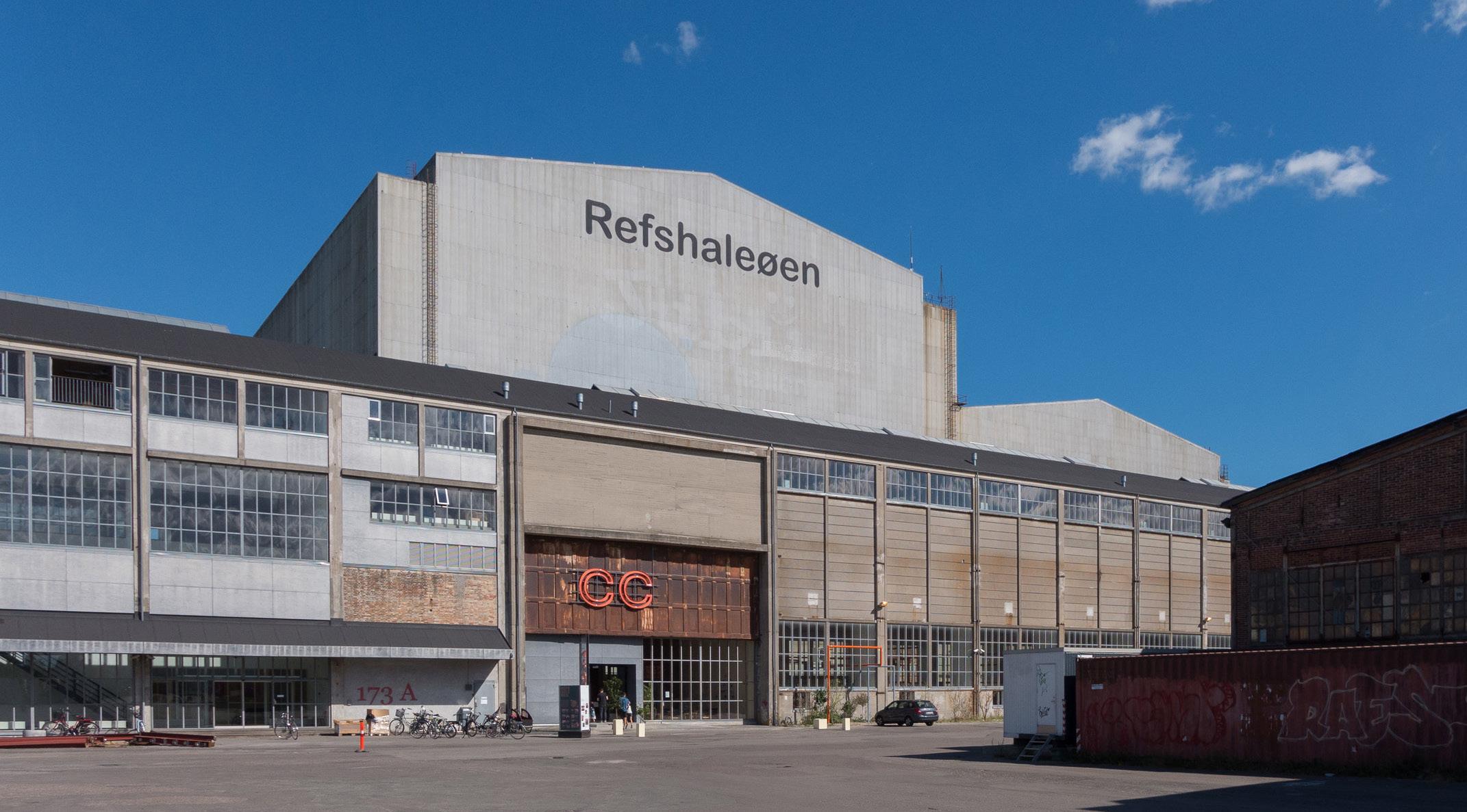
Refshaleøen, located in the Copenhagen's harbor, is a former industrial site with a rich architectural history. It was home to the Burmeister & Wain shipyard for over a century, an iconic symbol of Danish industrial history. Established in 1871, the site emerged after land reclamation efforts expanded the island and deepened the port’s waterways. At its peak, the shipyard employed 8,000 people, playing a vital role in Denmark’s maritime industry. However, in 1996, the shipyard closed following bankruptcy, leaving behind numerous industrial buildings that shaped the area’s character. The figure to the right shows a historical image of Refshaleøen when the shipyard activities were still active.
Since then, Refshaleøen has transformed dramatically, with many of the abandoned buildings repurposed for contemporary use. These spaces now house a mix of creative entrepreneurs, flea markets, storage facilities, and cultural and recreational activities. Adaptive reuse has preserved much of the industrial architecture, incorporating materials like steel and maintaining a connection to the area's industrial past. The design and development of Refshaleøen also embrace its waterfront setting, integrating the surrounding environment into the area's evolving identity.
The architecture of Refshaleøen is defined by three key themes: impermanence and fluidity, reuse and new use, and working with water. Impermanence and fluidity are central to the area’s character, with many buildings designed for dynamic change. Some structures remain stationary but adapt to evolving uses, while others are physically movable, reflecting a sense of constant transformation. Reuse and new use also play a significant role, as former industrial buildings have been creatively repurposed for functions entirely unrelated to their original purposes. This adaptive reuse breathes new life into the area while preserving its industrial heritage. The figure to the right shows one of the warehouse adaptively reused as a bar in Refshaleøen.


Historical image of the B&W shipyard at Refshaleøen during its peak operations, showcasing the industrial activity that employed 8,000 workers, a symbol of Danish industrial heritage.
(Top) Architectural remnants of Refshaleøen reflecting its industrial past, viewed through a lens of adaptive reuse and historical appreciation. (Bottom) A repurposed warehouse transformed into a vibrant bar, demonstrating the site's modern creative reuse ethos.
Elaina Geiger
Xinya Liu
Caroline Lu Regy Septian
Finally, the theme of working with water is integral to the design ethos of Refshaleøen. Buildings take advantage of the harbor’s proximity, incorporating the ocean and water features in ways that are both structurally functional and aesthetically appealing, creating a seamless connection between the built environment and its natural surroundings.
There are examples of these different themes across much of the site. For example, Reffen food market is an outdoor food market that is made up of shipping containers that have been rearranged to create spots for local vendors to occupy. There are also examples of pop-up events, like Copenhell, the annual heavy metal music festival, that are impermanent but still contribute greatly to the character of Refshaleoen. Reuse and new use is also a central theme in much of the site’s architecture, which can be seen through the Copenhagen Contemporary museum that occupies what used to be an industrial manufacturing building during the site’s shipyard history. Also, a popular cafe and harbor bath on the site called La Banchina occupies what used to be a security guard’s office, but is now a place for recreation and leisure. Lastly, the site’s architecture works well with water, like the Urban Riggers, which are floating homes made from shipping containers that are located off the coast and provide housing for students. These examples showcase how Refshaleøen's architecture seamlessly weaves together its industrial heritage, creative adaptability, and connection to the surrounding harbor, creating a dynamic and multifaceted urban environment.


Public Realm and Space
Copenhagen and Refshaleøen exemplify contrasting yet complementary approaches to public space design, offering valuable insights into how urban areas can integrate recreation, culture, and civic life. Copenhagen's public spaces are renowned for their structured, familyfriendly environments, creative reuse of infrastructure, and civic integration. Meanwhile, Refshaleøen stands out for its informal, adaptive use of industrial land and vibrant community atmosphere. Together, these approaches highlight the potential to create innovative, inclusive, and sustainable urban spaces that serve diverse needs.
Refshaleøen’s waterfront spaces are informal and dynamic, encouraging social engagement and leisure. The Reffen Waterfront offers a relaxed swimming area with harbor views, drawing both locals and tourists. La Banchina combines harbor swimming, sunbathing, and dining in an intimate setting, while Halvandet features a beach bar environment with water sports, deck chairs, and tables that create a lively social space. Margreteholm Harbor, in contrast, provides a serene setting for walking and cycling, characterized by industrial charm and tranquility. To enhance its waterfront offerings, Refshaleøen could introduce floating platforms for swimming, pop-up events, or green spaces, blending organization with its unique creative atmosphere.
Copenhagen’s approach to water access is more formalized, emphasizing safety and accessibility. Spaces such as Islands Brygge Harbour Bath provide designated pools and sunbathing areas, catering to families and ensuring secure water access. Svanemøllen Harbour Bath offers a quieter setting for peaceful waterfront activities, while Ofelia Beach presents a casual summer retreat for swimming and lounging. These well-structured spaces demonstrate how clear zoning and safety measures can broaden public access to waterfronts while maintaining an organized, family-friendly environment.


(Top) Reffen Copenhagen Street Food, the largest street food market in the Nordic region. (Bottom) La Banchina, a harbor bath & café, reflecting adaptive reuse of a former security office into a hub for leisure.
Islands Brygge Harbor Bath, a structured and family-friendly waterfront recreational space in Copenhagen, illustrating formalized public water access.
(Top) Sektionshaller, an example of preserved industrial architecture, showcasing adaptive reuse potential. (Bottom) Baghaven beer bar, part of the Mikkeller brand, utilizing industrial structures to integrate cultural and recreational activities.
Urban Riggers at Refshaleøen—floating homes made from shipping containers, representing innovative housing solutions aligned with the site’s industrial and maritime character.
Refshaleøen excels in repurposing industrial spaces for community and cultural uses. Copenhagen Contemporary (CCA), a transformed warehouse, serves as a modern art center that integrates industrial heritage with contemporary exhibits. The Reffen Street Food Market is a vibrant hub of food stalls, cultural events, and community engagement, operating year-round. Halvandet similarly showcases creative waterfront reuse, combining recreational activities with social spaces. Building on these successes, Refshaleøen could connect its shipyard to the waterfront via pedestrian bridges or walkways, turning the area into a cohesive cultural hub for art installations and community events.
Copenhagen’s creative reuse of space often incorporates multifunctionality and sustainability. Copenhill, a wasteto-energy plant, doubles as a ski slope and hiking area, exemplifying the integration of infrastructure with recreation. Superkilen, as show to the right, transforms a park into a cultural tapestry of global artifacts, providing a space for skateboarding, walking, and socializing that reflects its neighborhood's diversity. Tivoli Gardens blends entertainment with landscaped beauty, creating a multifaceted public space for leisure and performances. Ofelia Plads hosts cultural events and gatherings in a flexible waterfront setting. These examples highlight how innovative design can maximize public space utility, offering inspiration for Refshaleøen to scale its projects while retaining its creative identity.
Copenhagen’s civic spaces play a vital role in public life, blending cultural and civic functions. Christiansborg Palace Square is a central site for governance, public speeches, and protests, emphasizing its civic importance. City Hall Square (Rådhuspladsen) hosts public events and social gatherings, serving as a focal point for community engagement. These spaces demonstrate the power of public venues to bring communities together through shared civic and cultural experiences. Refshaleøen could incorporate similar spaces to host public events and foster a sense of community while maintaining its informal and creative character.


Mobility and Access
Copenhagen has set ambitious transportation and sustainability goals for 2025, aiming to limit car usage to no more than 25% of all trips while ensuring that public transport, cycling, and walking each constitute at least 25% of trips. Additionally, the city plans to increase daily walking trips by 20% compared to 2017 levels, encompassing both walking-only journeys and those incorporating public transport.
In 2022, Copenhagen had 142,400 cars and an impressive 745,800 bicycles, with bicycles outnumbering cars by more than five times. Over the past five years, the number of passenger cars increased by 13%, outpacing the city’s 5% population growth during the same period. Meanwhile, the number of bicycles grew by 11%, underscoring the city’s strong cycling culture.

Refshaleøen, a key area of Copenhagen, is served by two transit stations: the harbor bus (Havnebussen) and a traditional bus station, both of which boast waiting times of less than 10 minutes. Copenhagen’s bus system is organized into three categories. The A-bus offers frequent service with waiting times between 3-7 minutes, primarily during daytime hours, and focuses on central city routes. The N-bus provides nighttime service to fill gaps left by the A-bus, while the S-bus serves suburban areas with faster, limited-stop routes that connect efficiently with the A-bus network. This diverse bus system ensures comprehensive coverage for the city and its suburbs, catering to commuters at all hours.
Copenhagen’s rail transportation includes the S-train and the Metro, with the S-train forming the backbone of the city’s public transport system. Future expansion plans include the proposed M5 Metro line, which, if constructed, will improve connectivity in Refshaleøen. This plan is currently under public consultation as part of the Copenhagen City Council’s environmental impact assessment. Additionally, three Harbor Bus lines operate in Copenhagen, two of which serve Refshaleøen, with a typical waiting time of around 20 minutes.


An infographic from the Copenhagen 2025 plan outlining ambitious sustainability and transportation goals, including reduced car dependency and increased walking, cycling, and public transport use.
A rapid transit map for Copenhagen, showing existing and planned lines, including proposals for the M5 Metro line to enhance connectivity in Refshaleøen.
(Top) Refshaleøen skatepark—a vibrant space for sports and community engagement within an industrial setting. (Bottom) Superkilen, a multifunctional park blending global cultural artifacts with recreational opportunities, emphasizing diversity and creativity.
Copenhagen City Hall Tower and Square, a central civic venue hosting public speeches, protests, and community events, highlighting the role of civic spaces in fostering cultural and public life.
Cycling infrastructure is central to Copenhagen’s transportation network. The PLUSnet bike network prioritizes safety and convenience with wide lanes (at least 2.8 meters) that accommodate both fast and leisurely riders. These lanes are designed to make cycling accessible for all, whether for commuting or recreational purposes. Green cycle routes enhance this network by offering scenic paths through parks, alongside the harbor, and along quiet streets, providing a tranquil alternative to busier roads while incorporating rest and exercise areas. Figure 11 displays a biking scene on Copenhagen's street.
Cycle superhighways, another integral component of Copenhagen’s cycling strategy, aim to facilitate longdistance commutes, particularly those exceeding 5 kilometers. These routes are designed to provide seamless connections to major train stations and bus stops, integrating cycling with public transport. However, their implementation requires political approval and inclusion in local municipal plans. One such superhighway is planned for Refshaleøen, with the route already designed but still awaiting funding. If realized, bicycle traffic along the Østerbro-Amager route is projected to increase by 250%.
Copenhagen has also made strides in road safety. In 2022, the city recorded 154 road deaths, reflecting a 15.2% reduction compared to the 2017–2019 average. Key focus areas for further improvement include single-vehicle accidents, head-on collisions, intersection incidents, vulnerable road users, and young drivers. By 2030, Copenhagen aims to reduce road fatalities to 90 or fewer and limit the number of slightly injured persons in traffic to no more than 10,000.
These initiatives reflect Copenhagen’s commitment to sustainable, multimodal transportation, prioritizing cycling, walking, and public transit while enhancing safety and environmental sustainability.


Infrastructure
Refshaleøen faces significant infrastructure challenges and opportunities as it evolves into a more accessible and sustainable urban area. The primary access road, Refshalevej, suffers from inconsistent quality, emphasizing the need for upgrades to ensure safety and functionality. Key infrastructure, including an active wind farm supporting Copenhagen’s renewable energy goals and a wastewater treatment plant providing essential services and jobs, highlights the area's critical role in the city’s development. However, limited transportation access - reliant on a single road entry and insufficient public transit options like a lone bus stop - creates barriers for residents and visitors. This dependence on car infrastructure is exacerbated by inadequate pedestrian and cycling amenities, such as limited sidewalks, bike parking, and protected lanes. Challenges include poor road maintenance, inconsistent signage, and inadequate nighttime lighting, all of which hinder urban mobility and safety.
Despite these shortcomings, Refshaleøen benefits from blue-green infrastructure aligned with Copenhagen’s cloudburst plan, enhancing climate resilience. Pedestrianfriendly designs, including car-free zones, create safer, more engaging spaces for residents and visitors. Addressing transportation and accessibility challenges while leveraging these strengths will be pivotal in transforming Refshaleøen into a more inclusive and sustainable urban environment.
The Lynetten Wastewater Treatment Plant, established in 1980 on Refshaleøen, exemplifies transformative potential. Originally addressing severe pollution in the Sound, the plant has undergone modernization to meet evolving environmental standards. By 1999, water quality improvements allowed for recreational use, celebrated by the 2002 reopening of bathing zones. A 2014 upgrade enabled Lynetten to serve over one million residents, generating renewable energy such as natural gas, district heating, and electricity. Lynetten supports Copenhagen’s sustainability goals, educates the public with thousands of annual visitors, and remains vital to the city’s development.


Infrastructure challenges in Refshaleøen, including single access via Refshalevej and limited public transport, highlighting the need for enhanced pedestrian and cycling amenities to improve connectivity.
Lynetten Wastewater Treatment Plant on Refshaleøen, demonstrating its pivotal role in sustainability, public education, and urban development while supporting Copenhagen’s renewable energy goals.
Bicycle rush hour in Copenhagen, emphasizing the city's strong cycling culture and infrastructure designed to prioritize safety and accessibility.
Cycle superhighways in Copenhagen, illustrating long-distance bike routes connecting key transit hubs, with plans to expand to Refshaleøen for integrated and sustainable commuting options.
Denmark’s 2021 infrastructure plan further reinforces this vision, with a 161 billion DKK investment through 2035 to enhance efficiency and sustainability across rail, road, and public transport. More than half of the funding is dedicated to railway projects, aiming to improve national connectivity and service reliability. Key developments, such as the Metro Line M5 and Nordhavn Tunnel extension, reflect Denmark's commitment to sustainable urban transformation.
Refshaleøen and Lynetteholm stand to benefit significantly from these initiatives. The Nordhavn Tunnel extension, a 1.4 km cut-and-cover project, will strengthen connectivity between new districts and central Copenhagen, enabling the development of 40,000 homes and workplaces in Nordhavn. The proposed Metro Line M5 will introduce 10 new stations, alleviating congestion on existing lines and enhancing public transport access to Refshaleøen and other key urban areas. Complemented by studies like the Eastern Ring Road and green initiatives such as bicycle networks, these projects underscore Copenhagen’s leadership in creating a more integrated, sustainable, and dynamic urban future.
Lynetteholm also plays a crucial role in Copenhagen’s climate resilience strategy, protecting low-lying areas like Refshaleøen from northern storm surges. Featuring adaptable coastal defenses and landscape elements that absorb wave energy, it balances flood protection with scenic views and accessibility. Designed for flexibility in response to evolving climate conditions, Lynetteholm enhances urban resilience while integrating green spaces, eco-friendly transportation, and renewable energy. By addressing climate and urban challenges simultaneously, the project aims to transform vulnerable areas into thriving, sustainable neighborhoods, supporting Copenhagen’s vision of a livable and future-ready city.


Visualization of Lynetteholm, a climate-resilient development incorporating coastal defenses, renewable energy, and green spaces to protect and enhance urban areas like Refshaleøen.

Stage II Framework
REfshaleøen: REgenerate, REtain, REimagine
REfshaleøen
REgenerate, REtain, REimagine
Part 2 Frameworks
Emerging Framework Development
Visioning and Initial Urban Design Concepts
Following the initial research and analysis, in Part 1, the students re-grouped into another three teams, mixing and distributing the knowledge gained by the analysis groups, and began to develop three draft framework approaches for the transformation of Refshaleøen. They thought again in layers and systems, along the lines of the analysis “lenses”, but this time as a generative exercise that could inform planning proposals. As they defined key goals and guiding principles, and crafted a draft framework strategy for future development, the students were tasked to continually think between the scale of the immediate area of Refshaleøen and the context of broader Copenhagen.
Collectively the studio developed three unique framework plans, illustrating a range of approaches and deploying a variety of system strategies. Each of
the three teams took different approaches to issues of historic and cultural preservation; urban form and structure; as well as natural landscape and public open space. Additionally, the frameworks illustrate a range of attitudes about key planning variables such as the existing wastewater treatment plant, and the on-going debate about its permanence or potential re-location, as well as Lynetteholm, and the relation of its planning to the future of Refshaleøen.
After visiting Copenhagen, midway into Part 2, and meeting with local architects, planners, landscape architects, engineers, city planning officials and the shipyard’s current property management entity, the students came back to Philadelphia with new insights and energy to refine and finalize their frameworks.


Framework 01
Korsvej / Crossroad
Our design is driven by our desire to preserve. We aim to maintain the site's current character, including its use, typology, and identity. We are building upon the existing fabric of the site, both physical and historical, to highlight the korsvej, or crossroad, that emerges. This crossroad is the nexus of all activity on the site, from current art and cultural pursuits to future residential activity.

Framework 02
Shipyard Reimagined: Refshaleøen
Our framework for Refshaleøen centers on creating a wellintegrated urban environment with a focus on accessibility, diversity, and sustainability. The main commercial street runs from the city's entrance all the way to the inner harbor, branching into two commercial corridors that will eventually extend into Lynetteholm. This layout ensures a continuous flow of activity and connectivity throughout the area.

Framework 03
Friluftsliv
At the heart of this proposal is the Scandinavian concept of Friluftsliv, a philosophy that emphasizes a deep connection to nature and encourages outdoor experiences as an integral part of daily life. Rooted in Nordic culture, Friluftsliv is about fostering a lifestyle where nature is not separate from urban life, but woven into it. It promotes well-being by encouraging people to engage with the environment, whether through recreational activities, peaceful walks, or simply spending time outdoors.
Korsvej / Crossroad

Introduction
Framework Introduction
Our design is driven by our desire to preserve. The character of Refshaleøen is defined by its industrial remnants and vibrant informal activities. We aim to maintain the site's current character, including its use, typology, and identity. We are building upon the existing fabric of the site, both physical and historical, to highlight the korsvej, or crossroad, that emerges. This crossroad is the nexus of all activity on the site, from current art and cultural pursuits to future residential activity.
Key Analysis

Over the past few years, Refshaleøen has experienced organic growth. The site has become lively with a wide variety of activities and programming. From the Copenhagen Contemporary to a paintball arena, uses are diverse and draw in a range of visitors - locals and tourists alike. Site activity is mainly concentrated on the western side, along a vertical corridor identified as the creative spine. Maintenance of the organic growth of creative and cultural uses on Refshaleøen should be prioritized; the site should continue to exist as a hub for artists, designers, manufacturers, entrepreneurs, and food scientists.
Given Refshaleøen’s low elevation, physical connections between the land and water should be intentionally designed to mitigate sea level rise, while prioritizing biodiversity and cohesion. Innovative adaptation strategies should combine public spaces for entertainment and social purposes with infrastructure to reduce the effects of climate change.
The site’s two public transit connections – the bus and harbor bus – connect Refshaleøen directly to the center of Copenhagen. However, these options are limited and the only alternatives are to drive or bike, which take roughly 15 minutes from the city center. Refshaleøen’s physical separation from the city center creates a barrier for those wanting to visit or live on the site; public transportation connections must be expanded, especially as the development of Lynetteholm begins.
Refshaleøen’s housing supply is sparce, as the only two developments are temporary student housing for around 300 residents. Housing on the site must increase, with residential units that are 40m2 or less to promote affordability and density. Social housing should be prioritized on the site to combat the threat of gentrification, as housing costs in the area are far too high to promote inclusion on Refshaleøen.
REfshaleøen
REgenerate, REtain, REimagine
For the purposes of this framework, the wastewater treatment plant and northeast corner of the site have been excluded due to complexities and costs related to moving the plant and the construction of Lynetteholm.

Caroline Lu
Isabel Mulay
Joey Tang
Ashley Zuo
View of Refshaleøen from the harbor.
The Copenhagen Contemporary art center on Refshaleøen.
Concept Generation
Principles
Our team has developed five principles, which acted as our framework as we analyzed Refshaleøen and designed our diagrams and the site’s massing. These principles are based on the vision outlined by Refshaleøens Ejendomsselskab A/S - the property development company - and our observations when visiting the site.


Improve site connectivity and accessibility to the city center and Lynetteholm through physical infrastructure, public transit, programming, and green space.
Promote sustainability and resilience by utilizing renewable energy and integrating green and blue infrastructure into the public realm.
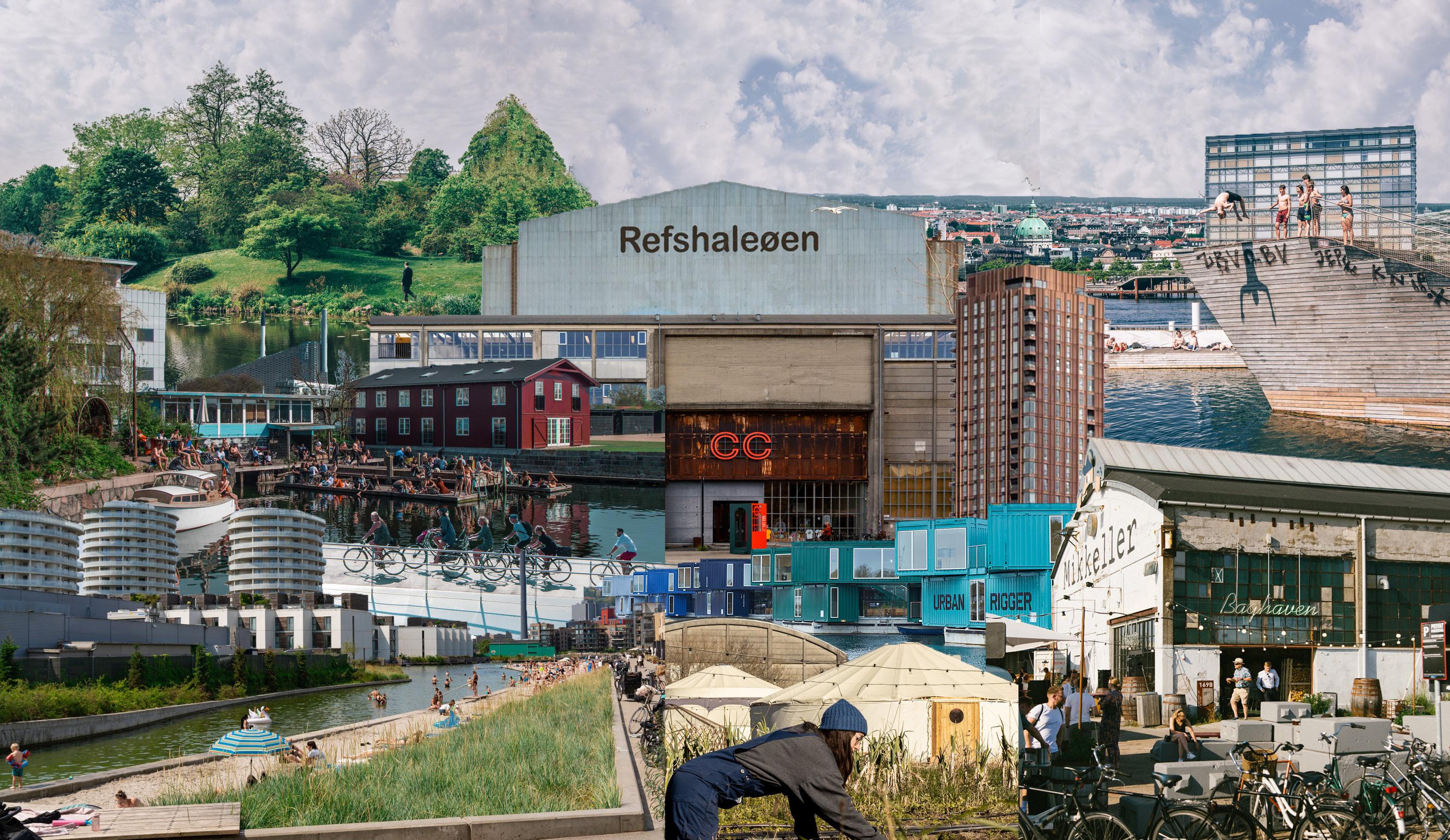
Develop jobs, housing, and public spaces that attract locals and tourists alike, while promoting inclusion and equity through mixed-income housing and cultural creative uses.
Maintain the site’s existing character in use, typology, and community, focusing on human-scale development, historic architecture, and experimental design that blends the existing urban fabric with the traditional city context.
Our collage visualizes our conceptual framework for Refshaleøen by combining existing activities and buildings on the site with benchmarks for success from around the city. We have highlighted the site’s iconic features, like the harbor bath, the Wolf Building, and the Urban Rigger development, signaling our desire to expand the public realm, preserve industrial character, and develop informal spaces. The collage also includes images from greater Copenhagen, like biking to promote connectivity, green spaces for resilience, and large apartment buildings to demonstrate density.
Capitalize on the site’s proximity to the ocean by developing waterfront public spaces, renaturalizing the landscape, and implementing innovative uses such as floating infrastructure.
Preservation
We focus on maintaining buildings and places such as the Wolf Building, the urban farm, and Reffen, while preserving open spaces like the berm and the forest.

City-Scale Connection
Our desire is to integrate Refshaleøen into the larger city context. One of the ways this can be achieved is through a network of green spaces, commercial corridors, and transit. The existing green belt in the harbor district and the future green belt along the coast of Lynetteholm can be connected through our site to improve biodiversity and cohesion. This connection doesn’t have to be explicit; vegetation integrated into the urban fabric will facilitate this. We are looking to extend Copenhagen’s vibrant and active city center into Refshaleøen further. The open and commercial spaces in the city center - which are colored yellow - will continue onto our site through the enhanced arts corridor and eventually up through Lynetteholm.
We are enhancing mobility by connecting Refshaleøen, Lynetteholm, and the harbor district with an integrated transit system. Our plan includes extension of both bus and harbor bus routes. A more defined vehicle circulation loop on site has been outlined to streamline traffic and minimize interaction with pedestrians and bikes. The new Metro 5 line will connect the harbor districts, Refshaleøen, and Lynetteholm with the city center, creating a cohesive citywide transit loop.


Design Basis
In terms of site design, our main focus is the active art and culture corridor formed by the Wolf Building, the Copenhagen Contemporary, Reffen, and other studios, as well as the historic industrial production line and corresponding dry dock. At the same time, we want to capitalize on both sides of the waterfront, by creating a continuous linear public space. This public park is building upon the existing open space that is currently on the site. Together, these corridors intersect at a central hub of activity, creating a crossroad. The remaining areas will each form distinct neighborhoods, with the most direct path to the central crossroad. Each neighborhood will have its own community-centered open space, establishing a distinct neighborhood character and forming a cohesive network. If the city decides to move the wastewater treatment plant, this space can easily become integrated into this design as a fourth neighborhood.

01
Preservation of the vertical arts and culture corridor and the horizontal historic industrial production line.

03
Delineation of neighborhoods from remaining area outside of the crossroad.

02
Creation of a linear public space, spanning from one waterfront to the other.

04
Formation of community-centered open spaces, establishing distinct neighborhood characteristics.

REfshaleøen: REgenerate, REtain, REimagine
Framework
Layer 1 - Public Space
Our public space is organized around two main spines that form a central crossroad, serving as the primary framework. The creative spine, a central commercial street, is designed to extend the character of Copenhagen into Refshaleøen. The green spine connects the waterfront experience and functions as recreational space for the site. Additionally, we have three smaller branches that extend into the different neighborhoods. We aim to maintain the informal, active feeling around the student housing and Reffen, which is supported by an informal spine. The waterfront spine lies to the east, linking Refshaleøen with Lynetteholm. Finally, an amphitheater forms an events spine, creating a trendy and experimental space.
Layer 2 - Mobility
We aim to enhance connectivity and accessibility in Refshaleøen while minimizing public vehicle use to create a pedestrian- and bike-friendly environment. Emphasizing public transit, we will add an additional harbor bus stop and two bus stops, distributed evenly around the site. These stops will all be equipped with bike-sharing stations, expanding the city’s shared bike network and promoting multi-modal transportation.
The Wolf Building will act as a transit hub, with a Metro 5 station, bus stop, and parking garage. Concentrating these functions at the center of the site will ensure that visitors are within a five-minute walk radius of most cultural and economic activity on Refshaleøen.
The plan also includes an inner vehicle loop, which only operates in one direction. This loop’s purpose is to slow private vehicle traffic and ensure the majority of the site remains open and safe for pedestrians and bicyclists. This loop can eventually connect north to Lynetteholm, as illustrated by the red dashed lines. The 37 bus route can also be extended into Lynetteholm, to provide additional public transit connections for both sites.
An outer bike loop provides cyclists with a scenic trail that accesses the entire site, plus opportunities to eventually link it with a network on Lynetteholm. A bike bridge from the western shore of Refshaleøen will connect to Nordre Toldbod, in the city center.


Layer 3 - Land Use
Our framework aims to preserve the existing land uses along the creative spine, which are activities that make Refshaleøen the vibrant destination it has become. At the same time, we seek to expand residential land uses to accommodate additional future residents. These residential areas will be complemented by necessary retail and institutional functions that allow Refshaleøen to stand on its own as a new Copenhagen neighborhood. To support future residents and supplement existing site programming, we plan to add more designated open and recreational spaces. These areas will be integrated into the fabric of Refshaleøen, ensuring that disordered yet functional activities continue to make the site lively and attractive.
Layer 4 - Built Form
We seek to minimize the development area by concentrating building density in certain areas, allowing for greater diversity in the urban landscape. We propose a physical connection between the Wolf Building and the Copenhagen Contemporary, making this structure a mixed-use core on the site. The lengthy Copenhagen Contemporary building, which cuts through the linear park, will have a glass section, allowing pedestrians to both see and walk through the building. To better integrate Refshaleøen with the surrounding context, the southern block of buildings that welcomes visitors to the site will take on a similar form to Margretheholm, a housing complex just south of the site. The ribbon-like buildings on site seek to maximize residents’ connections to green spaces and provide expansive, diverse views. These buildings should encourage future architects to create their experimental and bold designs here.
Layer 5 - Green Space
This plan seeks to connect the site’s green and open spaces into an expansive system that promotes biodiversity, resilience, and improves the human experience. The darker green areas are those that are dedicated green space. They include parks, forested land, and urban farming. The lighter green colors represent pockets of vegetation that are integrated into the urban environment. This includes greened residential courtyards, street trees, and planter boxes. These two types of green space help connect the entire site.


Character Areas
To better understand the different typologies that characterize our framework for Refshaleøen we have divided the site into seven sub-neighborhoods and four waterfronts.

Sub-Neighborhood 1 - Quintessential Copenhagen
To meet Copenhagen's housing needs and expand access to inclusive housing, the Quintessential Copenhagen residential neighborhood will deliver approximately 4,400 units of small-sized apartments. This district closely resembles the built form of Copenhagen's historical residential districts, ensuring density while providing ample public green space, retail, and institutional services. Winding streets and hidden courtyards make this neighborhood ideal for pedestrians and residents. This design fosters a community-focused space that aligns with Copenhagen’s core urban principles.


Aerial image of Copenhagen, demonstrating dense buildings and courtyards.
Public square in Copenhagen, with outdoor dining and seating. Busy streets with storefronts.
Sub-Neighborhood 2 - Experimental Residential
We are transforming the berm that separates the treatment plant from the residential zone into a linear park with sports fields and courts, including the padel courts that currently exist on the site. These recreational spaces will be interspersed between wild green spaces and meandering pathways where pedestrians and bicyclists can enjoy urban nature. The berm’s elevation can be utilized to provide bridge connections to nearby residential buildings.
The dry dock, which is post-industrial and often empty, will be transformed into a natural canal. Here, residents can swim and enjoy views of the ocean and the Wolf Building. Bridges will cross the canal, linking the buildings on each side and allowing for easy movement between the green spaces and residential areas. Hard-paved public space lines the canal, with opportunities for sunbathing, tables for gathering, and planter boxes to green the area.
The residential buildings in this neighborhood are arranged in a U-shaped layout, optimizing views of the park and canal, enhancing the interaction with surrounding green spaces, and creating pockets of public space between the built and natural environments.


South of the residential buildings, an amphitheater provides a versatile public green space. Vast lawns cover this area, increasing the pervious surfaces on Refshaleøen. With seating for over 15,000 people, this amphitheater is an event venue that doubles as a flood mitigation measure. The seating is raised incrementally, creating a basin at the stage to collect floodwaters from cloudbursts or storm surge. Vegetation will separate the residential buildings north of the amphitheater in order to reduce sound pollution.


Sub-Neighborhood 3 - The Green Fortress
The Green Fortress neighborhood is a preserved green area within Refshaleøen, featuring a mix of historic buildings and natural landscapes. This area is protected by the city government, as it is tied to Copenhagen’s military history. To maintain the character of this area, we will enhance and expand upon the existing military barracks. This approach will allow us to preserve the forested surroundings and maintain the low-density, tranquil atmosphere that defines this neighborhood. Plans for the area include adding a community center and theater to create a cultural and social hub that integrates seamlessly with the existing environment and buildings.


Teaterøen on Refshaleøen.
Old army barracks on Refshaleøen.
Quaint cottages located at the northwestern point of Refshaleøen.
Rendering of a linear park in Brooklyn, New York.
Drawing of a dry dock in Boston, showcasing bridges that cross the water.
A green amphitheater in Roskilde, Denmark.
Sub-Neighborhood 4 - Water Snake
Compared to The Green Fortress, the more modern Water Snake neighborhood provides over 1,000 units in a continuous building ranging from 7 to 12 stories. Similarly to the buildings in the Experimental Residential neighborhood, this building is designed to create pockets of space for residents to utilize. The jagged building provides those who live there with expansive, diverse views of the harbor, the city, and the ocean.
Residents here not only live closer to the water but also near the cultural and commercial hub of Refshaleøen. The harbor bus will stop here, providing residents and visitors with an additional connection to the city center. Recreational floodable infrastructure, like sunken basketball courts, will enhance community experience and protect residents.


Sub-Neighborhood 5 - Impermanent Spaces
Not every corner of Refshaleøen needs to be developed. We aim to maintain some flexibility in Refshaleøen by keeping this site as a temporary and informal space for creative activities and community events. This area is already host to various annual festivals, like O Days Festival and MoveCopenhagen.
There are existing impermanent structures here already: the CPH Village and Urban Rigger residential developments. We look to expand these structures to provide more temporary student housing. This housing will be industrial in nature, utilizing more shipping containers to match the aesthetic of the neighboring housing units and the overall character of Refshaleøen.


Sunken basketball court in Rotterdam, the Netherlands. Apartment building near Tjuvholmen, in Oslo, Norway.
A MoveCopenhagen activity on unused land. (Top) Urban Rigger. (Bottom) CPH Village.
Sub-Neighborhood 6 - Cultural and Creative Core
Over the years, Refshaleøen has garnered a reputation in Copenhagen as a trendy, hip area. To maintain this local culture and image, we plan to keep the built form in the Cultural and Creative Core neighborhood to preserve the existing businesses and creative communities, which are housed in transformed industrial buildings. Most notably, we will preserve Reffen, the outdoor street food market that is a driver for visitors to the site.
The pedestrian network in this neighborhood will be improved, as current conditions are suited for industrial vehicle traffic. Tree lined pedestrian streets that integrate stormwater management solutions will separate the large warehouse buildings. Bicycle infrastructure, like dedicated bike lanes and bike racks will allow residents in other neighborhoods to enjoy the activities and amenities provided by Refshaleøen.
This neighborhood not only serves as the cultural core of Refshaleøen, but also acts as a hub for innovation and collaboration, fostering a unique blend of artistic and entrepreneurial activities that attract both local residents and visitors alike. It remains a dynamic space where new ideas can thrive within the existing buildings, ensuring the area's vibrant character is preserved for future generations.


Sub-Neighborhood 7 - Events and Transit Hub
Located in the center of Refshaleøen, the Wolf Building occupies a significant area but is not in complete use. It serves as a major landmark of Refshaleøen, welcoming visitors to the site. Instead of removing this icon, we plan to renovate the building, endowing it with the functions of a transportation hub and events center.
We envision a large glass wall, illuminating the various events occurring within the building. The interior will be multistoried, with an open atrium in the center. The various levels will contain event and music venues, bars, and clubs. We want to create a central location where these uses can continue to make Refshaleøen a lively destination.
The M5 line will have a station that exits inside this building. A new connected building to the south will provide parking, retail, gym space, and house other existing uses, like the Paintball Arena. A 17-story residential tower with about 450 residential units, will enhances the skyline and add to the residential density on the site. To the north, a second, 18 story tower will add 510 more residential units to the site.


A workshop at one of Refshaleøen's many studio spaces.
Informal public space at Reffen.
Park 'n' Play parking garage in Nordhavn.
(Top)
Example of large building with glass side. (Bottom) Inside of the Battersea Power Plant in the United Kingdom.
Waterfront 1 - Western Waterfront
The waterfront pedestrian experience along the western edge of the site features scenic walkways that encourage walking, jogging, and socializing. Interactive elements like waterfront cafés, lookout points, and water access for boating or swimming enhance the experience. The outer bicycle loop will be integrated into this waterfront path, encouraging multi-modal transit.

Waterfront 2 - Renaturalized Harbor
At the renaturalized harbor, existing hard edges will be transformed into a waterfront where residents and visitors can engage with the water organically. A pedestrian and bike bridge will cross this area, connecting the Water Snake neighborhood with The Green Fortress. This beach area will be open to the public, with direct access from the city via the harbor bus stop. Saunas, swimming, and sunbathing characterize this location.


Waterfront 3 - Harbor Bath and Hard Edges
This waterfront is an extension of the existing informal swimming that takes place near Reffen. Centrally located near the creative core, it will have an established waterfront that emulates popular harbor baths in Copenhagen. The connected green space will serve as an area for public gathering, socializing, and events.


Waterfront 4 - Activated Marina
The final waterfront is an activated marina, with storefronts, outdoor dining, and a lively boardwalk. Private boats can dock here for owners to explore Refshaleøen, and boat tours can launch from here.


Zorrozaurre waterfront in Bilbao, Spain.
Luxparken in Stockholm, Sweden
Islands Brygge waterfront in Copenhagen.
Aker Brygge, in Oslo, Norway.
Shipyard Reimagined: Refshaleøen

Key Analysis
Revitalization and Evolution of Refshaleøen
In the early 2000s, Refshaleøen began a transformative journey from its industrial roots into a thriving cultural and recreational hub. Through adaptive reuse projects, historic structures from the former Burmeister & Wain (B&W) shipyard were given new purposes, such as the conversion of one building into a contemporary art museum. Over time, the area evolved into a vibrant space characterized by a dynamic mix of art venues, food markets, event spaces, and recreational areas. This development has made Refshaleøen a popular destination for residents and visitors alike, blending the historical essence of Copenhagen with its modern cultural landscape.
Adapting to Climate Challenges
Climate change poses another critical challenge for Refshaleøen. Projections indicate that Copenhagen and its surrounding areas will experience increased flooding due to sea-level rise. In response, Copenhagen has announced Lynetteholm, a massive artificial island project slated for completion by 2070. This reclaimed land is designed to protect the city from flooding and storm surges. As Lynetteholm will run adjacent to Refshaleøen, any development on Refshaleøen must align with the broader flood resilience strategies associated with Lynetteholm.
Opportunities for Synergy and Integration
Challenges in Connectivity and Accessibility
Despite its success as a cultural hotspot, the informal and uncoordinated development of Refshaleøen over the past two decades has highlighted significant limitations in connectivity and accessibility. Currently, the neighborhood is accessible through only two public transport points: a harbor bus stop on one side and a bus stop on the other. These transit nodes are located at the edges of the neighborhood, restricting movement within the area. Addressing these connectivity gaps is a primary goal of our plan, which aims to enhance accessibility both in and around Refshaleøen.
Meeting Copenhagen’s Growing Housing Demand
Elaina Geiger
Zoey Guo
JY Kwok
Xinya Liu
Meanwhile, Copenhagen faces a pressing challenge of providing adequate housing to meet future population growth. Projections indicate a 7% increase in the city's population from 2023 to 2033. This growth underscores the need for new developments, including those in Refshaleøen, to expand the housing stock.Compounding this issue is the lack of affordable housing. Danish law mandates that 25% of new housing in any development must be affordable, a policy reflected in our plan to address future housing demands on Refshaleøen. Our plan thus seeks to address such future needs.
Refshaleøen holds potential for meaningful integration with Copenhagen's planning traditions and future developments. Waterfronts in Copenhagen have historically hosted major cultural and historical landmarks, and Refshaleøen continues this tradition with destinations like Reffen, Northern Europe’s largest outdoor street food market. Our plan seeks to further enhance this waterfront identity by strategically situating key attractions along the water, capitalizing on Refshaleøen's locational advantages. Additionally, Copenhagen's commitment to green space development is evident in its existing green belt and the proposed green belt on Lynetteholm. Refshaleøen, positioned between these two green corridors, offers a unique opportunity to create a seamless connection between them, fostering a unified and accessible green network for residents and visitors.
Addressing Existing Infrastructure Challenges
A significant obstacle to Refshaleøen's development is the wastewater treatment plant (WWTP) currently occupying a large portion of the area. Its presence poses challenges to transportation connectivity, land use efficiency, and environmental integration between inner Copenhagen, Refshaleøen, and Lynetteholm. Over the past four years, Biofos, the operator of the WWTP, has conducted feasibility studies to explore relocating the facility. While these studies remain inconclusive, our plan assumes the potential relocation of the plant, enabling a cohesive redevelopment vision for Refshaleøen.
Regional Spatial Analysis


As Copenhagen prepares for future growth and climate resilience, Refshaleøen represents a vital piece of the city’s urban puzzle.
By addressing its connectivity issues, aligning with housing and affordability goals, integrating climate adaptation measures, and resolving existing infrastructure challenges, Refshaleøen can emerge as a model of sustainable, inclusive, and forward-thinking urban development.
Vision and Principles

Our vision for Refshaleøen is to create a sustainable, accessible, and inclusive community that enhances access to nature, balances cultural and historic preservation with new development, and offers affordable and public amenities - harmoniously integrating urban life and natural beauty.
Enhance Refshaleøen’s connection to nature
Balance between cultural & historic preservation and new development
Ensure accessibility between key destinations and transport nodes
Maintain a supply of affordable housing
Collage and Vision for Refshaleøen
Concept

Refshaleøen's industrial history is a key piece of this neighborhood's identity that should continue to be obvious in its next stages of development. The zone in the top left that is to be preserved is an old military fortress built back in the 17th century, deemed by the City to be preserved. The axes that run through the center of Refshaleøen are a direct reference to the neighborhood’s shipyard origins, once used as the production axis for the ships constructed on this site. Many of the key buildings from this era, such as the Wolf Building and various storage containers, still stand today, serving as reminders of Refshaleøen's industrial power. These axes will be central to our design.

To reflect Refshaleøen's adaption as a vibrant music scene, our plan includes the development of supporting buildings in the center of Refshaleøen, designed to accommodate music venues and related activities. These spaces will ensure that music remains a core element of the neighborhood’s character. Along the axes, we will also introduce buildings that complement the neighborhood’s historical core. These additions will help maintain Refshaleøen’s dynamic, creative atmosphere.

While historic preservation is a key focus, we also recognize the importance of aligning Refshaleøen’s future with the broader goals of Copenhagen’s urban evolution. The city has increasingly prioritized green spaces and a connection to nature, even in urban environments. In keeping with this, our plan introduces a green belt that will provide an open, biodiverse space, seamlessly connecting Refshaleøen with the green areas of Christiania and the future coastal green barrier of Lynetteholm. This green corridor will be a key element in ensuring that Refshaleøen remains an attractive, sustainable, and livable space.

Building on the reinforced historical core and axes, our development will strategically extend these zones further south, north, and towards the harbor entrance area. This phased approach will allow for gradual and thoughtful expansion that respects both the historical fabric and the future needs of the neighborhood.

Finally, we hope to fill the rest of Refshaleøen with housing of all kinds – affordable, student, and market rate. This housing pattern will continue through Lynetteholm and will help Copenhagen meet its goal of increasing housing of all kinds throughout the city to account for the expected influx in population. The plan for Refhshaleon will be sequential in nature, laying the foundation for how Lynetteholm can be planned when it is developed.
By outlining this 5-stage development framework, we aim to provide a cohesive and adaptable roadmap for Refshaleøen’s transformation. This phased approach ensures that each stage builds on the neighborhood’s historical legacy while thoughtfully integrating cultural, ecological, and urban priorities. By preserving its industrial and historical identity, fostering its creative and cultural energy, and aligning with Copenhagen’s broader urban and housing goals, this plan establishes a sustainable foundation for Refshaleøen’s future and serves as a guiding template for the subsequent development of Lynetteholm.
Stage 2: Green Belt Connection
Stage 1: Historic Preservation
Stage 3: Historic Core Reinforcement Stage 4: Neighboring Zones
Stage 5: Sweeping Wedge
Framework
Our framework for Refshaleøen centers on creating a wellintegrated urban environment with a focus on accessibility, diversity, and sustainability. The main commercial street runs from the city's entrance all the way to the inner harbor, branching into two commercial corridors that will eventually extend into Lynetteholm. This layout ensures a continuous flow of activity and connectivity throughout the area.
At the heart of Refshaleøen is a vibrant transportation hub that facilitates easy movement in and out of the culturerich core. The aim is to establish a "15-minute city," where residents can walk, bike, or use public transit to reach essential destinations within 15 minutes.
Refshaleøen is bordered by expansive green and coastal spaces to the north and south, with diverse residential neighborhoods positioned between them. These neighborhoods will offer a range of housing options, including affordable and student housing, to accommodate the growing population. The commercial, recreational, and residential areas are seamlessly interconnected, creating a harmonious and well-integrated urban space.


The development vision for Refshaleøen is anchored in the assumption that the wastewater treatment plant (WWTP) will eventually be relocated, creating new opportunities for transformation. This vision also considers the planned addition of Lynetteholm, proposing an upward extension of the current development pattern. This approach includes residential blocks with diverse housing types—ranging from affordable units to multi-family homes and single-family dwellings—all organized around a central commercial corridor. These neighborhoods will be interspersed with pocket parks, creating vibrant, livable spaces. For now, the scope of planning is focused solely on Refshaleøen itself.
The site is envisioned as six distinct districts, each with its own identity that contributes to the overall character of Refshaleøen. These districts include:
1. Timeless Refshaleøen
2. The Green Belt and Pocket Parks
3. The Waterfront Promenade
4. The Music Core
5. The Coastline
6. The Residential Villages
This district-based approach respects existing preservation priorities while anticipating the future expansion of Lynetteholm.
Spatial Framework of Refshaleøen
Zoning Framework of Refshaleøen

REfshaleøen: REgenerate, REtain, REimagine
Composite Layers

This image represents our *Physical Layers of Development* for Refshaleøen, providing an integrated depiction of building forms, transportation flows, and the layout of open and public spaces. By overlaying different colors and annotations, the map clearly conveys functional zoning and planning intentions
The primary access road to the city originates from the industrial area at the southern end. Along this main thoroughfare, landscaped green strips create a visual and ecological connection between the green space at the base of the development and the adjacent green belt, enhancing the area's overall cohesion and environmental quality.
A secondary road, designed as a commercial corridor, offers a vibrant streetscape lined with groundfloor commercial spaces and diverse dining options. Prioritizing pedestrian and bicycle use, this corridor promotes walkability and sustainable mobility while allowing cars to pass at reduced speeds, fostering a balanced and lively urban environment.
At the entrance to the area, a parking lot is thoughtfully integrated within a green space, surrounded by abundant vegetation that harmonizes with the natural environment. This design ensures a seamless blend between the built structures and the surrounding greenery.
Built Form

The purple buildings on the map represent existing preserved structures, while the grey ones indicate new developments. Refshaleøen has established itself as an arts and cultural hotspot, and these locations are now integral to its identity. By maintaining contemporary designs alongside preserved buildings, we not only honor the area's architectural heritage but also retain the existing social character of Refshaleøen.
Currently, Refshaleøen is served by two bus routes, one harbor route, and a metro line that is still in the planning stages. However, the neighborhood’s internal transportation options are limited and need further development to fully meet the needs of residents and visitors.
Drawing inspiration from the case study of Nordhavn, which prioritizes green mobility, our transportation design encourages the use of public transport, biking, and walking as the primary modes of travel, while minimizing car usage.
To enhance connectivity, we’ve planned a major public transportation hub at the entrance of Refshaleøen. The upper levels of the hub will be dedicated to parking, while the ground floor will serve as a transfer point for buses and the metro. Additionally, outside the hub, there will be designated spaces for bike parking and shared bike rentals to promote sustainable commuting. For public transportation, our plan includes the addition of one more harbor station, two new metro stations, and an expansion of the existing bus routes to better integrate Refshaleøen with the rest of the city.
Road Network

Public Transit

Cyclist Network

Refshaleøen features an extensive and convenient cycling network, catering to both locals and tourists. The network includes five types of bike lanes to provide a range of cycling experiences

Bike Superhighway
This primary cycling route connects Copenhagen to Refshaleøen, offering a smooth and easy ride. It enhances accessibility, making it ideal for commuting or leisurely trips between the two areas.

Green Bike Paths:
Two separate green bike paths are designed for cyclists seeking a scenic and peaceful journey. One path runs through the green belt, providing a tranquil route through natural surroundings. The other path is a loop connecting the Harbor Station to the beach, offering riders a leisurely route with coastal views.

Historic Axis Lane:
This bike route runs through the historic preservation area, allowing visitors to explore the cultural and architectural landmarks of Refshaleøen while satisfying their sightseeing needs.

Community Bike Path:
This path connects different neighborhoods, providing residents with an easy and convenient way to travel for daily needs, making it a valuable addition to daily life.
Green and Public Space Network

Public and green spaces play a central role in shaping the connectivity and character of Refshaleøen. Inspired by Copenhagen's rich green infrastructure—marked by its blend of expansive parks, intimate courtyards, and extensive green belts—the plan for Refshaleøen replicates these diverse typologies to create a vibrant, accessible, and environmentally resilient urban environment.
In addition to green spaces, Refshaleøen features thoughtfully designed public spaces that align with the site's preserved axis. These areas serve as hubs for gatherings, recreation, and events, ensuring that the community is as connected to each other as it is to nature.
Public spaces along the inner harbor provide classic Copenhagen-style waterfront experiences, inviting residents and visitors to picnic, relax, and take in the views. The site is also home to diverse event spaces, from the
outdoor amphitheater at its center—ideal for concerts and performances—to larger open areas designed for festivals such as Copenhell. These spaces maintain the site’s tradition of hosting cultural and musical events while creating opportunities for new communal experiences. Existing landmarks like the Reffen food market and public skate park are preserved and enhanced to retain the site’s vibrant cultural identity.
The design ensures that green spaces are abundant, varied, and integrated into daily life, connecting residents and visitors alike to both nature and recreation. These spaces also address pressing environmental challenges, such as sea level rise, by incorporating permeable surfaces and natural features to mitigate future flooding events.
Hierarchy of the Green Network


Green Belt and Inner Harbor
The most prominent green space in the plan is the Green Belt, which runs along the southern perimeter of Refshaleøen. This corridor connects to Copenhagen’s existing Christiania green belt and extends toward the future coastal landscapes of Lynetteholm. Functioning as both a recreational area and a coastal buffer, the Green Belt features a diverse landscape of native plants, forested areas, and open fields designed to absorb stormwater and protect inland buildings.
To the north, an inner harbor beach offers a softer, natural edge where sand dunes meet the water. This open space connects people with the harbor, creating opportunities for relaxation and leisure while also acting as a natural defense against rising sea levels.
Pocket Parks:
Interspersed throughout the site, pocket parks bridge the Green Belt to the coastline. These smaller green spaces create natural breaks in the urban fabric, ensuring that residents remain connected to nature even when moving through densely built areas. Serving both aesthetic and functional purposes, pocket parks also act as water catchment zones during flooding, channeling runoff toward the harbor.
Community Parks:
Scattered throughout Refshaleøen, community parks offer more private, tucked-away spaces for relaxation and recreation. Varying in size and design, these parks integrate seamlessly into the urban environment, fostering a sense of intimacy and tranquility.
Character Zones


As the first area visitors encounter upon arrival, Timeless Refshaleøen will embody the essence of the site as recognized and cherished by Copenhagen. Key existing features such as popular restaurants like La Banchina and the Reffen Food Market, as well as social housing options like the Urban Riggers and CPH Village, will be preserved.
Building on this foundation, the plan introduces elements that celebrate the evolving character of Refshaleøen, particularly its impermanent arts and cultural spaces. A vacant lot will be repurposed into clusters of shipping containers, serving as temporary studios for artists, performers, and other creatives. These spaces will reflect the site's dynamic and experimental spirit.


At the heart of Refshaleøen lies the Music Core, a district designed to ensure that concerts and events—key aspects of the site’s identity—remain central to its culture. This area features the iconic Refshaleøen building, which will be adapted into an indoor concert and events hall, continuing the tradition of repurposing post-industrial structures.
Adjacent to the concert hall, an outdoor amphitheater will provide a venue for warmer weather performances while doubling as a floodable stormwater basin during off-seasons. Surrounding these venues will be open plazas and informal gathering spaces, fostering a lively and inclusive atmosphere.


To the north of the Music Core lies the Waterfront Promenade, a hub of mixed-use, high-density development that offers sweeping views along the inner harbor. This district’s layout follows the natural curve of Refshaleøen and Lynetteholm, creating an inviting commercial corridor.
At its edge, a boardwalk will connect the urban environment to the coastline, featuring ground-floor retail, office spaces, hotels, and high-rise apartments above. A lookout point at the western tip of Refshaleøen will provide stunning views of Copenhagen, with a water taxi stop conveniently located below.


Bordering the promenade is the Coastline, an open recreational space for strolling, swimming, and sunbathing while enjoying views of Copenhagen’s harbor. Inspired by other revitalized harbor neighborhoods, this area offers a peaceful retreat, utilizing the natural cove-like shape of the site for a secluded yet accessible experience.
District 1: Timeless Refshaleøen
District 2: Music Core
District 3: Waterfront Promenade
District 4: Coastline
District 5: Green Belt and Pocket Parks


On the southern edge of Refshaleøen lies the Green Belt, an extensive green space that acts as a permeable coastal buffer, protecting the site from sea level rise and flooding. This area will connect to neighboring developments through greenery, promoting biodiversity and offering pedestrians and cyclists an immersive natural experience.
Branching off the Green Belt, pocket parks weave greenery into the urban fabric, separating neighborhoods and connecting them through lush open spaces. These parks also serve as stormwater catchment zones, channeling excess water into residential courtyards and ultimately the harbor.


The Residential Villages anchor the southern part of Refshaleøen, bridging the dense commercial zones to the north and the expansive green belt to the south. These neighborhoods address Copenhagen’s pressing need for housing by offering varied densities and footprints, with an emphasis on affordability.
Drawing inspiration from the site’s organic and spontaneous development, the villages prioritize housing for students and low-income residents. Smaller, accessible units are a key feature, ensuring that the district is inclusive and supportive of diverse communities.
Massing


District 6: Residential Village

Intro
Key Analysis
Our contextual research is divided into three key frames: environmental, urban, and social. Each frame helps guide the design strategy to address the site’s needs and challenges.
Regy Septian
Vanessa Diaz
Khulan Enkhold
Yuan Ji
REgenerate, REtain, REimagine
At the heart of this proposal is the Scandinavian concept of Friluftsliv, a philosophy that emphasizes a deep connection to nature and encourages outdoor experiences as an integral part of daily life. Rooted in Nordic culture, Friluftsliv is about fostering a lifestyle where nature is not separate from urban life, but woven into it. It promotes well-being by encouraging people to engage with the environment, whether through recreational activities, peaceful walks, or simply spending time outdoors.
For the Refshaleoen redevelopment, we aim to incorporate this philosophy by creating a balanced relationship between urban spaces and nature. Our vision is to design a place where people can seamlessly live, work, and enjoy nature all in close proximity. This will be achieved through the integration of woodlands, accessible public spaces, walking and cycling paths, and sustainable architecture that encourages outdoor activities.
By infusing Friluftsliv into the development, we seek to make nature a daily experience for residents and visitors, enhancing both quality of life and community connections. The design will not only prioritize urban vitality but also ensure that natural landscapes remain central to the site, allowing for a vibrant, healthy, and sustainable environment.
Environmental priorities focus on New Nature, Sea-level Rise, and Cloudburst Management. To address these, the design proposes diverse open spaces that range from formal gardens to woodlands, creating a balance between human interaction and nature. Nature-based solutions will provide storm surge protection, while pervious surfaces will be used throughout the site to manage water runoff, reducing the risk of flooding and promoting sustainable water management.
Urban priorities include improving Water Access, fostering Creative Reuse, and encouraging Civic Integration. To enhance water access, the plan proposes creating additional canals, reactivating the waterfront, and integrating water into the public spaces. The preservation and adaptive reuse of historical buildings will maintain the area’s character while providing space for modern uses. Additionally, the creation of civic spaces will promote community engagement and foster a sense of belonging, ensuring the site remains a welcoming environment for all.
Social priorities address Population Growth, the increasing demand for Affordable Housing, and the need for Preservation at the City Scale. In response, the design proposes modular housing to offer flexible, affordable living options that can adapt to changing needs. By maintaining existing activities and the urban fabric, the site can continue to serve as a hub of creativity and community, preserving the identity of the area while addressing the pressing social issues of the city.
This comprehensive approach to environmental, urban, and social needs ensures that the development is not only sustainable but also responsive to the challenges of the future, creating a vibrant, adaptable, and inclusive community.


Key Principles
Building A Resilient Urban Fabric

The visions for Refshaleøen, rooted in community input, helped informed our team's vision for the site. We recognize the importance of building on the experiences and insights of Copenhagen’s residents to help address existing challenges and design solutions to create a more seamless and functional space.
These observations led to the development of the key principles for our proposed plan:
1. Urban Vitality
2. Continual Activation
A conceptual collage of a green, mixed-use Refshaleøen designed to encourage recreation, commercial growth, and vibrant living for residents and visitors. together. These elements will coexist with one another, allowing them to reinforce and amplify one another. This organic interaction will foster a balanced urban ecosystem where spaces are constantly in use, life and activity thrive, and green, sustainable practices support the longevity of both the environment and the community. Ultimately, the integration of these elements will work together to form a thriving, resilient, and sustainable urban fabric.
Next, we will explore each principle and illustrate them with photographs that showcase these principles in action.
3. Green and Environmentally Sustainable
Forming A Dynamic Urban Ecosystem
The figure above displays a collage that blends these key principles together in one environment. It is essential to recognize that these principles will naturally blend
2. Continual Activation


Shaping A Bustling, Lively Atmosphere
Urban Vitality can be defined as the energy that infuses a city and creates a culture or way of life there. This term can be defined as areas that are filled with residents, visitors, businesses, and public spaces, allowing the city to come to life.
It thrives on diversity of activities and uses, as well as movement, with walkable streets and easily accessible spaces that encourage people to interact, explore, and participate in the life of the city. In the case of Refshaleøen and Copenhagen as a whole, creating spaces with accessible movement require the consideration of the biking culture, a prominent form of transportation for Copenhagen residents. This vitality creates a dynamic, interconnected environment that is always in motion, making the site feel alive and inviting.
Consistency in the Use of Infrastructure and Resources
Continual Activation refers to the intentional design and management of urban spaces to ensure that infrastructure and resources are utilized around the clock. This approach seeks to foster activity at all hours for both residents and visitors. By implementing various amenities, such as, public spaces, mixed-use developments, and accessible transportation options, continual activation ensures an effortless flow of activity, whether through residential living, recreational use, or commerce. This approach would help enhances the livability of Refshaleøen and strengthen its economic vitality and sense of security, as spaces that are consistently active tend to feel more welcoming and exciting to visit.
3. Green & Environmentally Sustainable Green Ecosystem Engagement

Finally, this plan is led by envisioning Refshaleøen as a Green and Environmentally Sustainable location. Today, Refshaleøen is known for its summer activity spots, such as the harbour baths.
Enhancing Refshaleøen with greenery through its rewilding of trees or shrubs will allow for there to be engagement between the community and the natural environment. Whether there are children playing outdoors or adults getting fresh air, they will not have to go too far to access green spaces.
This collage represents the vision for the site. Starting on the western side, there’s an emphasis on higher density and urban activity, with a mix of high-rise buildings, landmarks, and expanded transportation networks. Moving eastward, the heart of Refshaleøen’s history is preserved, with the industrial buildings and container stores being maintained as key elements of the area's character. On the eastern side, open green spaces and modular housing take centre stage, alongside the preservation of the existing pond, creating a balanced mix of nature, community, and modern development.

Image of the Royal Square in Barcelona, Spain captured by the Family Adventure Project. Depicts a mixed-use, public space with green features.
Image of Stedsans, a restaurant located on a roof surrounded by an urban farm in Østerbro. Image captured by Anders Husa.
Image of the Reffen Street Food Market activated with visitors who are there to dance and eat. Image captured by the Reffen Street Food Market team.
Concept


To bring this vision to life, we propose dividing the site into two distinct zones. The western section will embrace higher density, incorporating transportation hubs, residential apartments, commercial spaces, and cultural venues, while the eastern portion will focus on preserving open, natural areas with a lower density.
This division is grounded in our belief that the site's existing characteristics should inform its future. The western area, already home to industrial buildings, commercial spaces, and student housing, will retain and repurpose its historical structures while expanding housing and commercial offerings to enhance its urban fabric.
In contrast, the eastern portion remains largely undeveloped, with informal green spaces and woodlands. Our proposal emphasizes ecological restoration and


rewilding, enriching these natural areas to foster biodiversity and create spaces that promote outdoor living.
By preserving the unique features of both sides, our plan offers a balanced approach to development. The western zone will serve as a vibrant urban hub, while the eastern zone will protect and nurture its green spaces, creating a dynamic juxtaposition of urbanization and nature.
This plan seeks to intertwine modernity, history, and nature, bridging the western urban activity with the natural beauty of the east, all while honoring the essence of Friluftsliv—a lifestyle where the outdoors is woven into the fabric of daily life.

Framework
Integrated in Urban Form of Copenhagen


Harmonizing History and Modernity
In Refshaleøen, a strategic urban plan carefully integrates the area's historical shipyard and industrial heritage with modern, high-density developments. This plan aims to preserve significant historical buildings and integrate them into a contemporary urban fabric, creating a vibrant core that respects the area's character. By utilizing historical elements like dry docks as focal points amidst less densely developed areas, the plan maintains a balance between construction and open spaces. These preserved structures are repurposed for commercial and mixed-use applications, complemented by new buildings that support residential, commercial, and recreational activities. The urban design preserves the traditional grid layout while incorporating organic elements that reflect Copenhagen's unique character and connect urban life with nature through thoughtfully designed green spaces and waterways, enhancing both mobility and quality of life.
Infrastructure and Urban Density
The introduction of the Metro M5 line promises to significantly transform Refshaleøen’s development landscape. Along with the planned Eastern Bypass exit tunnel, these infrastructural enhancements will improve connectivity to both the north towards Nordhavn and the south towards the Øresund Bridge. This provides an exceptional opportunity to accelerate urban growth in Refshaleøen. By strategically placing the future metro station near our urban core, which is ideally suited for new infrastructural developments, we are poised to cultivate a high-density area that seamlessly integrates residential, commercial, and recreational functions.
Extending Green Belt and Blue Network
Copenhagen's green and blue spaces are defining features of the cityscape, with the green belt along the southern side of the Inner City being particularly notable. The upcoming Lynetteholm project will extend this green belt, incorporating it into nature-based storm protection strategies. Our plan is to connect these green belts, enhancing storm protection while simultaneously providing spaces for public outdoor activities and biodiversity preservation. Additionally, acknowledging the integral role of water in Danish life, we propose extending the waterfront to improve public access and flood management. Our vision contrasts the more structured, urban waterfront on the west with softer, more natural edges on the east, effectively mirroring our dual approach to urban and organic planning.
Sustainable Transportation and Future Planning
Cycling, a cornerstone of the Danish mobility lifestyle, will be further supported by the planned supercycle highway through Refshaleøen. This route will not only improve connectivity but also increase the area’s attractiveness. We plan to integrate this route into our development strategy and extend it towards Lynetteholm, ensuring it complements our extensive bicycle infrastructure network. This network will not only cater to urban areas but will also be extended to support recreational activities in our natural preservation areas, enhancing the overall 'Friluftsliv' experience.
Building off existing organization of Refshaleøen
Blending History & Modern Development
Focusing on Refshaleøen, our commitment is to preserve the area's historic buildings and ensure that the industrial and shipyard heritage coexists with new, higher-density developments. These modern developments are strategically designed to infill and enhance the urban core. Moreover, historical elements like the dry docks are thoughtfully integrated within the natural landscape, serving as distinctive focal points. This integration ensures that the surrounding areas remain less densely developed, balancing new construction with open, green spaces.
Network
In maintaining the grid-based urban form and street layout, we preserve Refshaleøen's character within the urban core. At the same time, we are integrating organic design elements to fuse historical character with modern needs. This approach will imbue the site with a unique ambiance, reflecting the quintessential character of Copenhagen.
Functional Reuse and New Constructions
In Refshaleøen, preserved buildings are being creatively adapted for commercial and mixed-use purposes. The new constructions around these preserved structures are designed to accommodate a diverse mix of urban functions—including residential, commercial, and mixeduse spaces—along with civic and recreational activities. Adjacently, these areas are predominantly green with minimal urban interventions, promoting a balanced and sustainable environment.
Open Spaces
the green open spaces around the urban core are designated to support urban activities such as playgrounds, squares, and transit plazas. In contrast, more secluded green spaces cater to outdoor natural activities like camping, horse riding, and kayaking, enhancing the 'Friluftsliv' experience by making nature accessible directly from urban settings. Moreover, the extension of canals increases public access to water and supports waterbased mobility, integral to Danish urban life.


Layers of an Emerging Framework
Assets on Site
Climate change and housing shortages make it imperative to create more resilient and livable neighborhoods in Copenhagen. The framework for New Refshaleøen envisions a harmonious relationship between urban development and natural resilience, while preserving the site’s cultural heritage. This vision aims to transform Refshaleøen into a sustainable, vibrant district that addresses both current and future challenges.
Refshaleøen, with its unique industrial heritage and evolving urban fabric, presents an extraordinary opportunity to craft a visionary framework that balances urban density, natural landscapes, and sustainable infrastructure. Building on our comprehensive site analysis and planning approach, we propose a bold yet thoughtful transformation of this area, ensuring it becomes a model of sustainable urbanism in Copenhagen.
The existing site, characterized by low-density development and an irregular boundary condition, offers significant potential for reconfiguration. By retaining key assets such as the dry dock, the berm, and the water treatment plant, we aim to minimize embodied carbon and shorten the construction timeline. The water treatment plant, essential to the city's operations, will be reimagined and modernized, inspired by the innovative design of CopenHill. This approach ensures that functional infrastructure becomes an integral part of the urban and architectural fabric.
Our framework prioritizes the preservation and enhancement of natural assets. The self-rewilding land on the eastern edge of the site will be safeguarded and extended, creating vital green linkages to the park in the south and Lynetteholm to the north. A proposed canal system will redefine the site’s waterfront character, adding dynamic low-lying areas to manage stormwater while enriching the ecological and recreational value of the landscape.
As part of the development strategy, soil excavated during canal construction and site development will be repurposed to create a series of islets along the western edge of Refshaleøen. Following Copenhagen's precedent,
these reclaimed lands will address the city's increasing housing demand while offering new opportunities for waterfront living and community spaces.
The proposed street network introduces a well-defined layout anchored by a multimodal transportation hub at the central landmark. This hub will connect seamlessly with a potential bicycle bridge, further enhancing active mobility across the site. The canal system will introduce additional harbor bus stops, integrating waterborne transport into the urban network. A bold addition to the cycling infrastructure will see the bicycle network extend over the water treatment plant, creating a dynamic and elevated route for pedestrians and cyclists.
Balancing urban density with natural landscapes lies at the heart of our proposal. The architectural language of the new development draws inspiration from Copenhagen’s rich urban fabric, ensuring a varied and immersive experience for residents and visitors. The transition from the dense urban core in the west to a greener, more organic landscape in the east reflects a cohesive pattern that integrates natural and built environments harmoniously.
The master plan introduces elevated pathways that weave through key landmarks such as the Wolf Building, the green berm, and vertical structures like wind turbines. These pathways not only connect the site physically but also create opportunities for engaging public spaces. From an aerial perspective, the spatial transition across the site reveals a delicate balance between urban intensity and natural assets, extending this vision to Lynetteholm and future developments in Copenhagen.
One of the defining features of our proposal is the elevated supercycle pathway above the water treatment plant. This innovative infrastructure serves as both a public space and a functional connection, allowing people to observe and interact with the city’s essential systems in operation. It demonstrates how infrastructure can evolve beyond its utilitarian purpose, becoming an engaging and educational element of the urban environment.


Current Refshaleøen
The Green and Blue
Multi-model Connection
The Industrial and Cultural Heritage
Islets and Blocks Grid and Nature

REfshaleøen: REgenerate, REtain, REimagine
Characterized Neighbourhoods
01 The Piers
02 Wolf Island
The Piers serve as the gateway to Refshaleøen, welcoming visitors while acting as a cultural and social hub that connects neighbourhoods. This area enhances the sense of arrival and invites exploration with its vibrant character.
Integrated Multi-Modal Transport Hub
At the core is a transit hub featuring a new metro station, waterbus services, bus facilities, and ample bike parking. This hub ensures seamless connectivity across Refshaleøen, supporting high volumes of commuters and tourists with expanded waterbus routes, bike paths, and buses. It also functions as a lively communal space with civic amenities.
Innovative Floating Community
The existing piers will be transformed into a sustainable floating community, including urban riggers and innovative housing units on water. This development offers unique living experiences while celebrating Copenhagen’s maritime heritage. The relocated Copenhagen Contemporary Museum enriches the arts scene, creating a multifunctional space where culture, transit, and housing converge.
Together, these features make The Piers a model of accessibility, sustainability, and community, aligned with Refshaleøen's development goals.


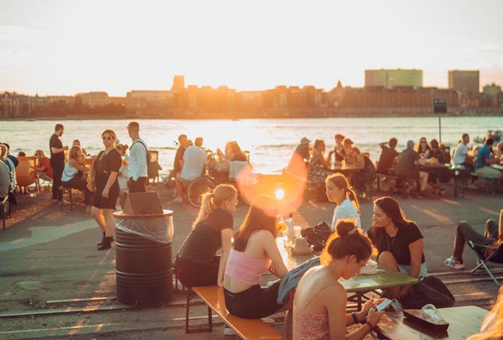

The development plan for Wolf Island centres on the expansion of the bustling Reffen Market towards the historical Wolf Building, which is set to anchor the neighbourhood's cultural and commercial activities. This expansion is meticulously designed to stimulate local commerce while providing versatile spaces for cultural events, such as art exhibitions, which can utilize these areas during the market's off-season. These adaptable spaces are intended not only to support ongoing commercial activities but also to accommodate seasonal cultural dynamics, enhancing the island’s appeal year-round.
Furthermore, the architectural design of the area thoughtfully includes surrounding canals, which play a crucial role in enhancing water connectivity. This feature is bolstered by the addition of a new waterbus station, ensuring that Wolf Island is well-integrated into the city's broader transportation network. This connectivity is crucial for knitting Wolf Island more tightly into the urban fabric of Copenhagen, making it a key node in the city’s landscape of movement and interaction. As a result, Wolf Island is set to become an indispensable hub for both creativity and commerce, reflecting the vibrant future envisioned for Refshaleøen.


Integration of functions
The Oculus, NYC
The Wolf Building as creative and commerical hub
03 Bayflower Harbour
The Development of Bayflower Harbour
Bayflower Harbour, located on the western side of Refshaleøen, combines "bay," reflecting its coastal connection and recreational focus, with "flower," symbolising biodiversity and environmental consciousness. "Harbour" represents a communal waterfront space for public gathering, leisure, and connection with nature.
Southern Bayflower Harbour
The southern half will feature a mixed-use commercial and residential area. Existing buildings, except the skate park and Reffen Street Food Market (relocated east), will be preserved. New 5-6 storey buildings with ground-floor commercial or recreational spaces and upper residential levels will increase housing options and attract economic activity.
Northern Bayflower Harbour
The northern half will include low-density housing, waterfront activation, and green spaces, offering a quieter urban setting. Strictly residential areas support permanence and expand Copenhagen’s housing stock.
To the west, new islets formed from surplus soil will provide additional housing while maintaining the harbour’s character, addressing the city’s housing crisis.


Pearl Point: A Residential Gateway
04 Pearl Point
Pearl Point, located at the southern tip of Refshaleøen, is envisioned as a low-density residential neighbourhood. Its name reflects a distinctive waterfront community and a key entry point to the larger Refshaleøen area, situated along Refshalevej—the main road connecting Refshaleøen to Copenhagen.
Visitors arriving via Refshalevej will experience Pearl Point's welcoming residential atmosphere. During peak tourist seasons, nearby harbour buses provide an alternative transport option, ensuring privacy for residents.
Addressing Copenhagen's Housing Needs
The Friluftsliv plan aims to tackle Copenhagen’s housing challenges, where affordability has become a pressing issue. Initiatives like CPH Village provide temporary, low-cost student housing in Refshaleøen, set for a maximum duration of ten years.
The Pearl Point development proposes creating additional housing, with 40% designated as affordable. This initiative will offer new living spaces for individuals and families, helping alleviate housing pressures and providing accessible options for low-income households.


Point Ruston in Ruston Tacoma, Washington. Image captured by
Point Ruston building with a commercial groundfloor and residential living spaces on the upper floors. Image by MovetoTacoma.com.
An image of the water, boats, and residential homes in Sluseholmen et Sydhavn. Photo by de Architect, part of VMN Media.
An image of colorful, vibrant homes in Malmö, Sweden beside green and water features. Image by Ilya Varlamov.
Image by UNEP Neighborhood Guidelines displaying a water feature running in between a neighborhood in Malmö.
Image by Buildipedia.com showcasing pedestrians walking alongside green path in Malmö.
05 The Woodlands
The Woodlands: Nature and Community
The Woodlands, in eastern Refshaleøen, preserves a dense forest enhanced through soil remediation to support biodiversity. Inspired by SLA’s “City Nature” concept and projects like Malmö’s Anchor Park, it integrates untamed natural ecosystems with urban life, fostering ecological and social benefits.
Modular Housing for Affordability
In partnership with CPH Village, modular housing addresses Copenhagen’s housing shortage. These flexible units adapt to changing needs and climate challenges, ensuring sustainable, affordable living while meeting future demands.


A Blue and Green livable neighbourhood with heritage preserved.
A new outdoor amphitheatre near The Woodlands blends culture and ecology, inspired by Brooklyn’s Prospect Park Bandshell. With trees as sound barriers, it creates a vibrant space for arts, music, and community gatherings, harmonising with its natural surroundings.


A Copenhagen Neighbourhood
Inspired by the philosophy behind both traditional and contemporary developments across Copenhagen, the site will transform into a walkable neighborhood that seamlessly integrates natural assets and public spaces. It will be a vibrant area designed to meet the needs of both locals and visitors while providing a habitat where flora and fauna can thrive.
Music Venue in Nature
Anchor Park, Malmö
Central Park, New York
Refshaleøen, Copenhagen
Vesterbro, Copenhagen

Stage III Project Exploration
REfshaleøen: REgenerate, REtain, REimagine
REfshaleøen
REgenerate, REtain, REimagine
Part 3 Projects
3
Project Explorations
The Urban Design Potential of the Framework Concepts Building off of the emerging frameworks developed during Part 2, the students, working in smaller groups, identified key questions or issues to be explored and further developed within the context of their framework plans.
Through this exercise the students made a jump in scale and specificity to dive into a key aspect of the plan and through this exercise, interrogate and push forward the development of the urban design potential of the concepts put forward by the Frameworks in Part 2.
Through this exercise, the studio collectively explored and illustrated the potential of their Framework approaches with each of the five teams identifying for themselves a topic of focus for their study and the scope of the
project. The focus of these projects included: The design of streetscapes and mobility corridors; The integration of resiliency and blue-green infrastructure strategies with public space; The design, economics, and governance of multi-use districts that have the capacity to integrate and mediate Refshaleøen's culture of live performance with new residential communities; And the definition of key public space typologies that can both accommodate a variety of day-to-day and seasonal social activities as well as support the integration of nature within the everyday life of the City.

Project 01
Multiuse, Event-oriented Neighborhood Strategic Plan
Project 02
Developing a Land-use and Transit Nexus

Project 03
Weathering the Storm: Cloudburst and Coastal Resilience Design for Refshaleøen


Waterfront Plaza
Project 04
Social x Large
A cohesive and vibrant corridor that bridges people and nature with community activities spaces and thriving green and blue features

Project 05
Copenhagen Public Space Typological Study

Project 01
Multiuse, Event-oriented Neighborhood Strategic Plan
Based on Framework 1

A key aspect that guided us into this phase is the transformative power of events in defining and modifying Refshaleøen. This island has developed a unique character as a dynamic gathering place, where people come together and contribute to its bottom-up, organic identity.
Take Copenhell, for example—Denmark’s largest rock and metal music festival. This four-day event draws approximately 35,000 guests, volunteers, and employees each year.
Temporality & Flexibility
The image above illustrates the transformation of Refshaleøen during Copenhell. As a post-industrial island with minimal development, Refshaleøen features many vacant lots and concrete spaces that remain largely unused when no events take place. However, during events like Copenhell, the landscape comes alive. Vacant lots and forest spaces are transformed into vibrant hubs filled with stages, bars, small shops, camping areas, and an atmosphere of energy, excitement, and fun.
Refshaleøen hosts a variety of other events as well:
• Foxy Festival, a folk music celebration;
• Winter ice skating, offering seasonal recreation;
• Farmer’s markets, connecting local communities. It is these events—and the inherent flexibility they bring— that breathe life into Refshaleøen, shaping its identity and character.
Our goal is to preserve this unique character. This does not mean conserving one or two specific spaces; rather, it involves maintaining the temporality and adaptability that define Refshaleøen as a vibrant, ever-changing place.
Vision Statement Goals & Objectives
The core concept of our project is to create a multifunctional neighborhood: cultivating a vibrant, inclusive, and thriving community in Refshaleøen through the promotion of flexibility.
To support this idea, we developed three visions and guiding principles, focusing on events, communities, and the economy:
• Preserve and enhance Refshaleøen’s unique identity;
• Maintain a vibrant and sustainable residential experience;
• Contribute to job creation and economic development opportunities.


Challenges arise as the city envisions an influx of 25,000 new residents into the harbor district, alongside 1.1 million square meters of development on Refshaleøen.
With this projected growth, a critical question emerges:
How can we preserve Refshaleøen’s unique identity while addressing potential tensions between local residents and visitors?
Group Members: Ashley Zuo, Joey Tang, Jia Yang Kwok


We began by examining the existing events and their seasonal patterns.
• Summer is the busiest season, with numerous events bringing life to the island;
• There are also activities planned around Christmas and New Year;
• However, for the rest of the year, during non-event periods—including our site visit—Refshaleøen appeared quiet, empty, and lacking vibrancy.
This observation inspired us to consider a solution: building a neighborhood that remains vibrant during daily life while continuing to host events during holidays and peak seasons. What, then, defines a multi-functional neighborhood? And how can we achieve it in a way that balances residential life with event programming? The answers lie in fostering flexibility, integrating spaces for daily use and events, and creating a resilient community that thrives year-round.
Case Studies 01 New York City
The entertainment economy has been shown to stimulate economic development in cities worldwide. For example, in New York City, the nightlife economy—a major subset of the broader entertainment sector—contributed 299,000 jobs, $13.1 billion in salaries, and a total economic output of $35.1 billion in 2016. This impact spans multiple industries, including arts, live events, recreation, bars, and clubs.
A key driver of the entertainment economy’s success is its reliance on agglomeration effects, which amplify spending and consumption across interconnected industries. For instance, someone attending a music event is likely to purchase food and beverages or engage in other activities within the surrounding area. This clustering effect boosts spending, creates economic synergies, and contributes to broader economic growth. While Refshaleøen is considerably smaller in scale than New York City, we believe that designing its development with a focus on fostering a vibrant entertainment economy can produce similar net benefits for its residents and for Copenhagen as a whole. By leveraging cultural events, music festivals, and creative spaces to attract visitors, Refshaleøen can serve as a catalyst for local businesses, stimulate job creation, and support sustainable economic development for the neighborhood and city.
Case Studies 02 Sofieland, Malmö
Both Refshaleoen and Sofielund are located near the urban core, are industrial wastelands with rich cultural and artistic heritage, and both plan to designate residential areas while leveraging culture to develop the local economy. We drew on the planning, policy, and noise control measures of Sofielund, primarily including the cultural sound zone. We will introduce these aspects in detail later.
Case Studies 03 Clubcommission, Berlin
CLUBCOMMISSION is another resource of case studies in Berlin. It is a fundraising program to help music clubs to do noise protection. We looked at its projects such as the BIRGIT and BEER to look at the approaches and standards in noise insulation practices.


EVENTS
Shape Refshaleøen
Building on insights from our case studies, we set out to design a multi-functional event space. Events serve as the foundation for our spatial design, informing both its structure and adaptability.
We began by examining the components of existing events. Through event maps, we observed key examples:
• Copenhell and Distortion: These events require large spaces for stages and crowds;
• Karrusel: Known for its temporary amenities, such as the iconic carousel;
• O/ Day Festival: A more mixed-use event, integrating food and beverage areas.
Despite their differences in art genres, these events share several fundamental components:
• Stages and backstages, with some events featuring up to six stages;
• Social spaces where people can gather, sit, and interact;
• Food and beverage areas, alongside retail stores.
• Recreational amenities, such as temporary camping fields.
• Temporary attractions and installations that bring vibrancy to the spaces
While accommodating new spaces for development, it is essential to preserve the events that define Refshaleøen’s unique character. To achieve this, we relocated and reimagined the fundamental components, enhancing their vibrancy along two main axes.
Key event locations include:
• The Transit Hub: Beyond parking and transit stops, this area is reimagined as a mixed-use redevelopment, integrating food, retail, and indoor event spaces;
• The Stage Plaza: As the largest open-air space, it can host two stages simultaneously during events while serving as a plaza for large-scale weekly activities year-round;
• The Art Community: A distinctive residential district featuring ground-floor art programs, while doubling as a commuting space for event audiences;
• New Reffen: Relocated adjacent to the waterfront plaza and central plaza, this redesign creates a continuous, vibrant experience along the main axes.


• relocating movie studios, previously housed in the Wolf Building.
• A Marina and Industrial-Inspired Zone
During our analysis, we observed that different art genres tend to favor locations with distinct atmospheres:
• Relaxed music genres gravitate toward seaside venues;
• Heavier, distorted music prefers the immersive setting of forest areas;
• Photo exhibitions and similar art forms favor spaces close to central corridors.
With this insight, we designed event zones to reflect these preferences and offer distinct atmospheres:
• A Relaxed and Family-Friendly Zone
• A welcoming, laid-back environment featuring skateboard parks, hot tubs, and swimming pools. Art studios will also be located within this zone to support creative activities.
• An Experimental and Hard-Core Zone
• Catering to bold, avant-garde performances and experimental art. Spaces are also provided for
• Blending waterfront and industrial aesthetics, this zone offers unique settings for smaller, more intimate events along the marina.
While events are central to Refshaleøen’s identity, we also considered the importance of community development and everyday programming. Currently, the site includes indoor art venues, open-air flexible spaces, and food halls. However, community elements—such as art communities, residential neighborhoods, institutions, retail spaces, and markets that support daily life—remain underdeveloped. This realization brings us to the next chapter: Community Development.


COMMUNITY Development
Conflicts: Residents vs Visitors
Needless to say, there are a wide variety of fun moments happening in Refshaeloen. However, there are challenges we have to deal with. One key issue is how to maintain a cohesive community while ensuring that the infrastructures meet the basic needs of residents to keep the neighborhood functioning. For example, how to ensure residents' needs for public infrastructure and how to reduce noise impact on the living environment. We need to ensure that music lovers and professionals respect and understand the living experience of local residents, while local residents appreciate and are enthusiastic about the events. We aim to use planning to balance residents and visitors to create a young, diverse, and inclusive multifunctional community.
Conflicts: Housing vs Events
In some scenarios, events are almost enemies of residential housing. However, more affordable housing not only meets Copenhagen's overall housing needs but also promotes the sustainability of the multifunctional community, reducing living costs while bringing residents closer to music. The question here lays on how to balance the relationship between events and housing.
Noise
Spatially, the multifunctioning community gives convenience and variety of access to music events to the residents. Music Lovers, like me personally, would be dying to live in this neighborhood. However, living close to music also means your are living close to noise. It not only damages the health of people, but also raises conflicts between music lovers and residents. This map shows the potential noise impact based on our preliminary analysis and site design.
1. Mixed Use Sound Zone
To allow music events to happen, we regulate on noises. Drew on the Sofielund Cultural sound zone, the mixed use sound zone is a zoning overlay approach that allows certain amount of noise within the area. Ordinances including:
a. Noises observed indoor residential units must be below 50db.
b. Setback requirement: at least 10 meters to adjacent event space
c. Environment assessment Soundproofing requirement
d. Large events allowed by right if safety standards satisfied
2. Noise Regulation
Another way to make everybody happy is to actually control the noise volume. First, to manage the time schedule to balance out the time of events and community functions. This table is an adaptation from the Restaurant Operation Permit Noise Management Chapter. But here we propose more allowance and flexibility on noise. Draw from the CLUBCOMMISSION projects, we also identified key building and operating standards for noise management, such as noise insulation walls, music system to control volumes, and documentations to track and supervise the noise management process.


ECONOMIC Development
Moving forward, we believe that our concept for Refshaleøen will generate significant economic benefits for both the neighborhood and greater Copenhagen. This economic impact can be divided into three primary segments:
• Direct Impact: This refers to the immediate economic effects of spending at establishments in Refshaleøen. Revenue generated by businesses supports operational costs, pays employee wages, and contributes to tax revenues for the City of Copenhagen.
• Indirect Impact: Consumer spending not only affects the establishment where the initial transaction takes place but also has ripple effects. Businesses in Refshaleøen will purchase goods and services from adjacent industries (e.g., suppliers, vendors, and service providers), amplifying economic activity across the value chain.
• Induced Impact: This impact arises when employees working in Refshaleøen spend their wages on household consumption, such as groceries, housing, and leisure activities. This additional spending supports other businesses, generates further job creation, and stimulates economic activity throughout Copenhagen.
Additionally, ancillary spending plays a critical role in Refshaleøen’s economy. This refers to consumption tangential to the main activities—for example, visitors attending events, festivals, or cultural activities may also spend on dining, transportation, and retail within the area, further boosting economic growth.
By capturing these layers of economic impact— direct, indirect, induced, and ancillary—our vision for Refshaleøen aims to create a thriving, sustainable economy that benefits local businesses, residents, and the broader Copenhagen community.
To illustrate these economic impacts, we can walk through a visitor journey map for Refshaleøen:


• Ancillary Spending: Visitors might begin their journey by taking a taxi, rideshare, or the metro to reach Refshaleøen. This initial travel generates ancillary spending, benefiting transportation services and contributing to economic activity beyond the area itself.
• Direct Impact: Upon arrival, visitors engage in activities such as shopping at retail stores, dining at restaurants, or attending events. These transactions create direct revenue for businesses, supporting their operations, paying employee wages, and generating tax revenue for the City of Copenhagen.
• Indirect Impact: To meet customer demand and replenish supplies, these establishments engage in B2B (business-to-business) transactions with suppliers, service providers, and adjacent industries. This stimulates economic growth along the supply chain, further amplifying the impact.
• 4. Induced Impact: Increased consumer demand leads to job creation as businesses hire additional employees to meet customer needs. Workers, in turn, spend their wages on household expenses, dining, leisure, and other goods and services. This induced

• spending supports other businesses and contributes to broader economic activity across Copenhagen
Through this interconnected cycle of ancillary, direct, indirect, and induced impacts, Refshaleøen can serve as a key economic driver, benefiting businesses, creating jobs, and contributing to sustainable growth for both the neighborhood and greater Copenhagen. The triad of direct, indirect, and induced economic impacts can be effectively applied to the various entertainment-linked industries in Refshaleøen. These industries include Arts, Nightlife, Food and Beverage, Recreation, and Venues—each offering unique opportunities for spending, experiences, and economic growth.
These core industries can be further segmented into sub-sectors, highlighting specific events, activities, and consumption patterns. For instance, someone visiting an art gallery may also dine at a nearby restaurant or shop at a retail store. This interconnected consumption amplifies economic activity across sectors, making Refshaleøen a holistic, dynamic space that encourages cross-industry spending.
Developing these industries and their associated subsectors will also contribute to significant job creation for both Refshaleøen and Copenhagen at large. For example, establishing a music venue not only requires performers but also event organizers, sound technicians, security personnel, marketing professionals, and food vendors. These roles, and many others, form the ecosystem necessary for success.
By fostering such industries, Refshaleøen can generate a diverse range of employment opportunities, raising local employment levels and driving sustained economic growth. This is a non-exhaustive yet illustrative example of how transforming Refshaleøen into an entertainment hub can unlock economic potential for the area and the broader Copenhagen community.
User Experience
To illustrate the circular process of consumer spending and its positive economic impacts across various industries, we explore four user journeys that reflect diverse interactions with Refshaleøen:
• Anders and Anne: Copenhagen residents visiting from other parts of the city
• Suzie: A tourist from Berlin attending a music festival
• Jason: A music technician working at Refshaleøen’s music hub
• The Jansen Family: Local residents of Refshaleøen

9 AM - 12 PM
• Anders and Anne arrive at the newly established Refshaleøen metro stop to visit an art museum, contributing to direct spending in cultural institutions.
• Suzie checks into a hotel after flying in from Berlin to attend a music festival later that night, initiating ancillary spending on accommodation and travel services.
• Jason begins his workday at the music store, supporting Refshaleøen's creative economy.
• The Jansen family drop their children off at a local school before heading to work in other parts of Copenhagen, contributing to economic integration across the city

12 PM - 3 PM
• Anders and Anne finish their museum visit and have lunch at a local café, generating direct spending for the food and beverage industry.
• Suzie explores retail shops to buy souvenirs, stimulating indirect spending as businesses restock goods and engage with suppliers.
• Jason travels to the festival venue to begin setting up for the concert, contributing to event-related employment and consumption.
• The Jansen children finish school and attend nearby childcare services, a vital component of the local community infrastructure.

3 PM - 6 PM
• Anders and Anne roam Refshaleøen’s green spaces to relax after lunch, benefiting public recreational areas.
• Suzie has lunch at another restaurant before heading back to her hotel to prepare for the evening festival, sustaining spending in hospitality and dining.
• Jason continues his technical work, ensuring the festival operates smoothly.
• The Jansen family pick up their children and visit the local supermarket for weekly groceries, supporting neighborhood businesses.

6 PM - 9 PM
• Anders and Anne enjoy an early dinner and drinks at a bar before heading back home, further stimulating the food and beverage sector.
• Suzie attends the much-anticipated music festival, contributing to ticket sales, food vendors, and merchandise—directly benefiting the entertainment economy.
• Jason works on sound production during the festival and prepares for deinstallation afterward, representing employment opportunities within the events industry.
• The Jansen family enjoy family time at the local recreational center, playing virtual paintball with their kids, highlighting the role of accessible amenities in sustaining community life.
Conclusion
Throughout the day, Refshaleøen serves as a dynamic hub for events, experiences, and consumer spending, creating direct, indirect, and induced economic impacts that collectively drive job creation and economic growth. Visitors like Anders, Anne, and Suzie stimulate spending across arts, hospitality, retail, and recreation, while workers like Jason contribute to the entertainment infrastructure. Simultaneously, Refshaleøen is thoughtfully designed with local residents in mind, fostering a selfsustaining community where families, such as the Jansens, can live comfortably with access to essential services and recreational opportunities.
This interplay of visitors, workers, and residents positions Refshaleøen as a vibrant and inclusive entertainment hub, contributing to Copenhagen’s overall economic and social prosperity.
Concluding Remarks
In conclusion, our key concept is designed to cultivate a vibrant, inclusive, and thriving community in Refshaleøen through the promotion of flexibility.
This vision is embodied in our three core design and planning principles:
1. Preserve and Enhance Refshaleøen’s Unique Identity
2. Maintain a Vibrant and Sustainable Residential Experience
3. Contribute to Job Creation and Economic Development Opportunities
By anchoring our approach in these principles, we envision Refshaleøen as a space that seamlessly serves both local residents and communities as well as external visitors. This dual focus ensures that Refshaleøen contributes meaningfully to both economic growth and community development, fostering a dynamic, sustainable, and inclusive future for the area and for Copenhagen as a whole.
Project 02
Developing a Land-use and Transit Nexus
Based on Framework 2

Land Use Framework
In Phase 2, we conducted an analysis to identify both regional and site-level character zones, along with their corresponding land uses. These included the harbor entrance, music core, commercial area, waterfront area, and residential area.
Recognizing the intrinsic interrelationship between road construction and land use planning, we have further refined the character zones into a more detailed and systematic plan. This expanded framework incorporates specific land use sub-categories for each zone, providing a nuanced definition of their respective functions.
For instance, the commercial area has been subdivided
into retail, office, and mixed-use spaces, while the waterfront area includes recreational parks, public access points, and tourism facilities.
These refinements not only enhance the clarity and purpose of each zone but also play a pivotal role in shaping an integrated transportation strategy that aligns with the broader urban development goals.
This detailed categorization ensures that both the spatial organization and functional roles of each zone are clearly articulated, providing a robust foundation for optimizing connectivity and supporting sustainable urban growth.

Land-use and Transportation Network Focus Area


Based on the surrounding land use and varying pedestrian and vehicular traffic volumes, we have classified the road network into six distinct types to better accommodate the diverse transportation needs. These types include Main Roads, Collector Roads, Local Streets, Cycle Superhighways, Bicycle Lanes, and Shared Streets
Public transportation has been strategically integrated into high-traffic areas to improve accessibility for residents and visitors. Bus stops are spaced about 1/4 mile apart, ensuring a five-minute walk to the nearest stop. In line with the Metro Line 5 plan, two new stations have been added in Refshaleøen one at the city entrance for tourists and another at the residential area entrance for local commuters. Additionally, a new water bus stop connects to the Inner Harbor Area, offering a convenient transit option.

The area features a variety of bike lanes that intertwine seamlessly, including historical axis lanes surrounding the industrially transformed music center and commercial district, recreational trails connecting the waterfront to neighborhoods and community spaces, and mixed-use lanes shared with cars.
We have selected four distinct types of roadways for design, with a focus on their unique characteristics. In parallel, we have analyzed the relationship between these road types, land use patterns, and the surrounding built environment.
Each selected roadway type was chosen based on its potential to enhance connectivity and align with the specific functions of the surrounding areas. The design considerations include how the roadways interact with adjacent land uses, such as commercial, residential, and recreational zones, as well as their integration with existing architectural structures. This approach ensures that the roadways not only facilitate efficient movement but also complement the urban fabric and contribute to a cohesive urban experience.
Commercial Corridor Commercial Corridor
Location

The first typology is the commercial corridor at the entrance of Refshaleøen, one of the busiest areas in the city, surrounded by commercial spaces and the music core area. To improve accessibility, a large public transportation hub has been established at this entrance.The hub facilitates transfers between buses and the metro, with bike parking facilities available and shared bike rentals offered. This multimodal transportation center aims to enhance connectivity, reduce congestion, and promote sustainable travel options

Street Design


Car and Bicycle Parking, Copenhagen.
Outdoor Service, Copenhagen Denmark.
Local Lasbjornstade, Copenhagen Denmark.
Recreational Trail Recreational Trail
Location

The second typology is the recreational trail, a dedicated riverside path designed for both pedestrians and cyclists. This trail offers a scenic route, enhancing the overall user experience by providing direct access to the waterfront. At the end of the trail, a harbor station connects the area to central Copenhagen, facilitating easy access for visitors and residents alike.
Additionally, a loop has been incorporated into the design, allowing both cyclists and pedestrians to enjoy a circular route. The integration of these elements aims to promote active transportation while fostering a vibrant, leisureoriented environment.


Street Design


Waterfront Connectivity, Human-Centric Design, Shared Urban Spaces Cykelslangen, Copenhagen.
New walk-and bike bridge “Inderhavnsbroen” – spectacular design of beauty, style and function Nyhavn, Copenhagen.
Green Boulevard Green Boulevard
Location

The third typology is the green boulevard, which serves as a vital link between the green belt at the lower end and the beach area above. The central green strip introduces abundant greenery into the urban fabric, enhancing the overall aesthetic and environmental quality of the area. On the left side of the boulevard lies the commercial area, characterized by retail and office spaces, while the right side is dedicated to residential zones, providing a buffer between the two land uses. The integration of green space within the urban structure aims to promote sustainability, improve air quality, and foster a more livable urban environment.

Street Design


Green Infrastructure, Passive Recreation Spaces, Shaded Pathways; Sønder Boulevard, Copenhagen
Urban Event Space, Multi-Use Pathways, Civic Identity Sønder Boulevard, Copenhagen
Community Street Community Street
Location

The final typology, the community street, is the smallest road type and is situated within the residential area. Given the minimal traffic flow and the primary presence of local residents, the street design emphasizes comfort, safety, and convenience. The layout prioritizes creating a peaceful, resident-friendly environment that encourages social interaction and community engagement.
To support this, the design includes wide sidewalks, pedestrian-friendly crossings, and greenery, all contributing to a tranquil atmosphere. The minimal presence of vehicles further enhances the street's role as a safe, welcoming space for the local community, ensuring that residents can navigate their environment with ease and comfort.

Street Design


Public-Private Interface, Playful Design Pedestrian Priority; Bo01, Malmö, Sweden
Neighborhood in Norhavn Norhavn, Copenhagen
Project 03
Weathering the Storm: Cloudburst and Coastal Resilience Design for Refshaleøen
Based on Framework 2

Key Analysis

Sea level rise impacts coastal cities across the globe, and Copenhagen is no different. At a low elevation and close proximity to the ocean, the city is expected to see around 70cm of sea level rise by 2100.

Paired with sea level rise, storm surges will inundate the city with powerful waves and sea water during large storm events. By 2100, Copenhagen will experience over 2.5 meters of coastal flooding during a 1,000-year storm.


Cloudbursts, or sudden extreme rainfall events, are predicted to impact Copenhagen more as weather patterns shift due to climate change. The city defines a cloudburst as more than 15 millimeters of precipitation over the course of 30 minutes.

In 2011, Copenhagen saw the worst cloudburst in its history, with 100 millimeters of rain in an hour. It caused severe flooding throughout the city and $800 million in damage. In response, Copenhagen published a Cloudburst Management Plan in 2012 to better equip their stormwater system for future extreme events. Later, in 2017, they published a Storm Surge Plan to prepare for coastal flooding. Both of these plans align with Copenhagen’s Climate Adaptation Plan, which aims to make the city more resilient in the face of climate change.
Neighborhoods in Copenhagen have begun to implement physical interventions outlined in these plans. Østerbro, for example, is the first area of the city to integrate comprehensive stormwater management systems into its neighborhood. The use of nature-based solutions brings residents closer to the water by using it as a resource to enhance livability.
Elaina Geiger
Isabel Mulay
Aftermath of the 2011 flood.
Tåsinge Plads, a public square in Østerbro with green stormwater infrastructure.
Existing Conditions
Lynetteholm
To better protect the city from storm surges, Copenhagen has begun to develop Lynetteholm, a barrier island in the harbor. As an addition to Refshaleøen, Lynetteholm will mitigate some of the site’s risk of coastal inundation, but is not a comprehensive solution to the challenges that the site faces. Refshaleøen needs to take its own adaptive measures to match those of Lynetteholm, addressing not only storm surges, but cloudbursts and sea level rise as well.


A key aspect of Lynetteholm is the natural coast along the eastern side, designed to soften the impact of storm surges. Diverse landscapes will provide not only protection, but green public space and recreational assets for the city to enjoy. An opportunity exists to connect Lynetteholm’s future green coast with Christianshavn’s Enveloppe, a green belt that is just south of Refshaleøen.
Stormwater Infrastructure
In addition to this storm surge protection, Refshaleøen should adopt city-wide strategies for additional waterrelated risks. Green, grey, and blue infrastructure can manage flooding while enhancing public spaces and remedying additional environment challenges, like the urban heat island effect. As an underdeveloped site, Refshaleøen has the unique opportunity to integrate these water management tactics into the site’s public realm from the beginning, treating the two as a cohesive network.


Elevation
Currently, Refshaleøen is precariously placed in Copenhagen’s harbor, surrounded by water and only 2 meters above sea level.

Storm Surge
Similarly, in the event of a 1,000-year storm in 2100, the site will experience catastrophic levels of flooding from storm surges. The graphic below illustrates 2.5 meters of storm surge.

Sea Level Rise
If no interventions occur, Refshaleøen’s coastal edges are at risk of inundation from sea level rise. The graphic below illustrates 70 centimeters of sea level rise.

Cloudburst
In the event of a cloudburst, low elevation, impervious areas on the site are at risk of flooding.

Lynetteholm's future natural coast.
Renderings of Lynetteholm's coast.
Examples of green, grey, and blue infrastructure in Copenhagen.
How can water management strategies be integrated on Refshaleøen to
make it more resilient?
To ensure strategies to combat sea level rise, storm surges, and cloudbursts are implemented, design guidelines are necessary to direct development towards a waterresilient future. These guidelines should:

Ensure the site is protected from sea level rise, storm surges, and cloudbursts by implementing resilient, adaptable, and multi-layered water management systems.

Combine nature-based approaches with engineered solutions to create a cohesive and sustainable response to water challenges.

Design spaces that integrate natural and recreational assets, allowing residents and visitors to interact with water through the public realm and programming.

Utilize native vegetation to support habitat creation and biodiversity, ensuring that the site’s natural systems can thrive despite changing environmental conditions.
Site-Wide Design Guidelines
Site-wide guidelines specifically address two categories of water risks that Refshaleøen faces: Sea Level Rise & Storm Surge and Cloudburst & Flooding.
Sea Level Rise & Storm Surge
Design guidelines for Refshaleøen’s waterfront prioritize robust protection against sea level rise and storm surges while ensuring ecological and community benefits. Infrastructure along the waterfront should be resilient, with floodproof materials and elevated structures. High-risk flood zones should restrict development, emphasizing setbacks, terracing, and low-density uses. Coastal edges should integrate diverse materials like riprap, reinforced dunes, salttolerant vegetation, and intertidal habitats, designed with a layered ecosystem approach across wet and dry zones. Site elevation must be raised by 2 meters to safeguard critical infrastructure and public spaces, complemented by elevated landforms on the site's edge for storm surge defense. The human experience should be considered, with accessible, elevated public spaces and pathways ensuring continued coastal interaction despite environmental challenges.
Cloudburst & Flooding
Cloudburst design guidelines for Refshaleøen emphasize effective rainwater capture and management while integrating green infrastructure and multifunctional public spaces. Permeable surfaces, rainwater harvesting systems, and bioswales should reduce runoff and channel water to designated areas, supported by a cohesive and robust drainage network with capacity for extreme events. Grading and slope systems should guide water efficiently, preventing accumulation in high-use areas. Systems like backup retention basins and overflow channels provide added security against system failure. Green infrastructure - including green roofs, vegetated buffers, and urban trees - naturally manages stormwater while enhancing ecological and cooling benefits. Public spaces should accommodate stormwater through floodable infrastructure, serving both recreational and water management needs. By blending functionality and aesthetics, water features and visible stormwater systems educate the public and integrate seamlessly into the urban environment.
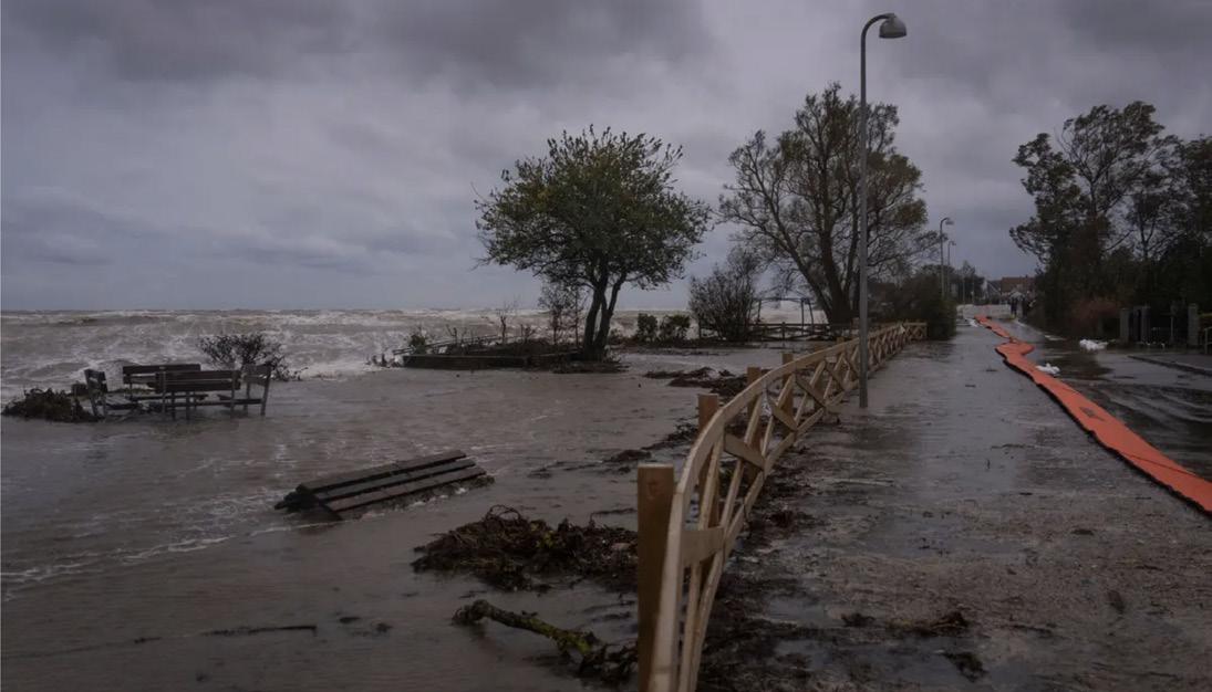

Storm surge in southern Zealand, Denmark.
Extreme flooding in the city after the 2011 cloudburst.
Zone Design Guidelines
Based on the framework developed in the previous phase, six zones on the site have been identified where specific interventions could be applied.

Phase II Framework
The original framework provides many natural assets that create a foundation for integrated stormwater management. Slight amendments to this plan have been made to enhance the connectivity of green spaces and stormwater mitigation measures, improving the flow of water throughout the site.

Six Zones

These zones form a comprehensive network that directs water away from inland urban areas towards the harbor and ocean. Primary flow indicates areas where large quantities of water will flow either above the surface or in pipes below the surface. The ultimate goal of these waterways is to direct water that falls on the site towards the harbor to the North. Secondary flow comes from the more urban, impervious areas that eventually join the primary flow paths. Natural drainage utilizes topography to direct water from higher elevations to the ocean.
Western Waterfront
Design Guidelines
The Western Waterfront serves as a resilient coastal flood levels, while a riprap edge mitigates wave energy


The waterfront should be elevated 2.5 to 3 meters above sea level. The riprap edge, which is visualized above, acts as a barrier to absorb the impact of large waves. To accommodate both pedestrian and bicycle traffic, the promenade should be at least 6 meters wide. Various types of programming, like benches or grassy areas, could exist along this zone, to encourage public activation. A variety of water access points should exist along the promenade, from floating docks that extend into the water to gradual steps that allow people to sunbathe and swim.
Case Study: Aker Brygge, Oslo, Norway
Aker Brygge exemplifies how urban waterfronts can balance resilience with the public realm. Its elevated promenade offers uninterrupted pedestrian access along the harbor, while stairs and platforms provide direct entry points to the water for recreation. The design includes flood-resilient features, such as raised edges and durable materials, ensuring longterm usability in the face of rising sea levels.


Green Belt
Design Guidelines
The Green Belt acts as the site’s first line of defense against storm surges and rising seas, prioritizing naturebased solutions. Elevated berms provide a barrier for coastal inundation while directing stormwater into retention greenways or back into the ocean. Layered ecosystems - from beach and dune to marsh and forest - filter runoff and enhance biodiversity. Recreational pathways weave through this zone, allowing visitors to engage with the landscape while maintaining its protective and ecological functions.
Case Study: Hunter's Point South, NYC
Hunter’s Point South Park is a leading example of nature-based solutions integrated into waterfront design. The project transformed a post-industrial waterfront into a vibrant public space, incorporating wetlands, marshes, and recreational pathways that mitigate storm surges while enhancing habitat diversity. The riprap edge provides effective protection from storm surges.


In this section, the Green Belt’s berm is 7 meters above sea level. Large storm surges should be stopped by this elevation change, which prevents the urban areas inland from being flooding. Topography is designed to purposefully direct rainfall into the Retention Greenways. A variety of ecosystems, all of which serve different purposes are layered in the Green Belt. The beach can be used for recreational purposes. Dunes provide necessary habitats for animals and plants. A wetland or marsh collects excess water as necessary. The forested area makes up the largest portion of this zone to increase the roughness coefficient, slowing the speed of water runoff and providing more pervious areas for this water to infiltrate the ground. Low-impact programming, like winding paths and benches for pedestrians, dot the landscape.

Images of the Aker Brygge waterfront.
Images of Hunter's Point South Park's nature-based solutions.
Retention Greenways
Design Guidelines
The Retention Greenways are designed to manage and channel stormwater during cloudburst events, reducing flood risk across the site. These large, vegetated corridors act as connective infrastructure, linking different zones of the site into a cohesive, adaptive system. The greenways feature higher edges and a depressed middle to collect water, while a gentle slope guides flow from the elevated Green Belt in the South toward the harbor in the North. Water from secondary systems, like the Community Parks and Amphitheater can flow into the greenways, facilitated by grey or green infrastructure. Stormwater is ultimately funneled under the boardwalk and into the harbor through outfall pipes.
Case Study: Kappelbach, Germany
The Kappelbach River was uncovered and reimagined to mitigate flood risks while enhancing ecological value. Similar to our Retention Greenways, Kappelbach utilizes natural slopes and vegetation to channel stormwater efficiently, with the capacity to hold large amounts of water when necessary.


The Retention Greenways will be large bioswales that act as a river during extreme storm events. These bioswales will be sunken and sloped into a U-shape to be able to retain and transport water as it is collected in the stormwater system throughout Refshaleøen. Surrounding the Retention Greenways will be transportation roadways for cars and cyclists on one side and pedestrians on the other, allowing all people traveling through to feel connected to both nature and water. Roads that cross these greenways should be elevated, as to not disrupt the vegetation and waterway.

Community Parks
Design Guidelines
Community Parks should prioritize resilience by incorporating flood-resistant infrastructure, ensuring these spaces remain secure and functional even during storm events. Public amenities, like skate parks or sunken soccer fields, will be integrated into the design as multipurpose floodable spaces, allowing the community to enjoy them during dry conditions while also providing crucial stormwater management during heavy rains. Nature-based solutions, such as bioswales, rain gardens, and topographic depressions, will help mitigate and direct stormwater.


Flood-resistant infrastructure should be able to retain 10–20% of stormwater volume during a 100-year storm event. Permeable materials, such as pavers, gravel, and reinforced turf, will be used for pathways and plazas to reduce runoff, while small canals, underground pipes, or bioswales will channel water into Retention Greenways. Biodiverse vegetation will be planted throughout, while active and passive spaces like playgrounds, permeable sports courts, and quiet garden areas will ensure year-round accessibility and functionality.

Case Study: Enghaveparken, Copenhagen
Enghaveparken serves as a strong example of integrating public infrastructure with flood retention systems. In dry weather, Enghaveparken is a vibrant recreational hub for the community. Its open lawns are used for picnics, sports, and relaxation, while its playground, sports courts, and bandstand host activities for people of all ages. The sunken areas, designed as retention basins, double as gathering spaces or informal play zones when dry, blending seamlessly into the park’s landscape. During wet events, these same sunken areas come into action as floodable infrastructure.


Kappelbach's natural U-shape to retain water.
(Top) Enghaveparken in dry conditions. (Bottom) Enghaveparken after a cloudburst.
Coastal Beach
Design Guidelines

The Coastal Beach is a biodiverse dune ecosystem that is resilient and salt-tolerant, ensuring it can withstand harsh coastal conditions. Passive stormwater management features will be integrated throughout the site to naturally handle runoff, reducing the risk of flooding and maintaining the health of the ecosystem. At the same time, the site should promote public access and recreation, providing spaces where visitors can enjoy the beach while maintaining the integrity of the natural environment.
Constructed dunes will emulate natural formations with heights ranging from 1.5 to 3 meters, depending on proximity to the waterline. These dunes will create habitats for diverse ecosystems while also protecting inland urban areas from storm surges, helping to dissipate the energy of powerful waves create a barrier against high tides. A gentle slope towards the harbor will promote natural drainage, and vegetative barriers, sand fencing, and shallow vegetated swales will manage runoff and reduce erosion. Public access will be provided via a raised boardwalk with designated access points to the beach to minimize impact on the dunes.

Case Study: Amager Beach, Copenhagen
Amager Beach is a local beach that residents know and love. It has both a sandy beach and vegetated dunes, similar to what the future beach on Refshaleøen could look like.


Amphitheater
Design Guidelines
The Amphitheater will have a basin-like structure to facilitate the collection and redirection of stormwater into an underground retention system. Channels will strategically direct excess stormwater safely into designated discharge zones, like the Retention Greenway or the harbor. The seating will be made of vegetated terraces that can withstand both stormwater and flood events. Additionally, vegetated buffers along the perimeter of the Amphitheater will serve a dual purpose: managing stormwater and acting as noise mitigation to protect the neighboring residential areas.
The Amphitheater will incorporate an underground retention system designed to manage a 100-year storm event, with a mechanical pumping system that ensures drainage within 24 hours. The base of the Amphitheater will be at a slight angle to allow for water to naturally travel downwards, and the seating throughout the space will be tiered and vegetated to act as miniature rain gardens that will catch and filter water during precipitation events.


Case Study: CU Centenary Park, Bangkok, Thailand
In dry events, CU Centenary Park serves as a performance venue, hosting events and activities for the community. In precipitation events, this park becomes a flood capture system, utilizing the open spaces and water features to manage stormwater runoff effectively. This dual-purpose function not only enhances the park's environmental sustainability but also ensures it remains a vital, adaptable space for both leisure and performance in an increasingly flood-prone urban landscape.


Amager Beach and its dunes.
CU Centenary Park's amphitheater.
CU Centenary Park's amphitheater flooded.
Outcomes
Once all of these interventions are in place, Refshaleøen will see significantly lessened effects of extreme water events. The impacts of sea level rise and cloudbursts will both be negligible, and storm surges will be shielded from infiltrating the inner urban area by the protective coastal measures that have been proposed.

Next Steps
In order to implement these design guidelines, partners that have successfully worked in both Copenhagen and Denmark to enhance the sustainability and water resilience of urban spaces have been identified. These organizations include national and local government agencies, private development firms, landscape architects, and urban planners, all of which are valuable resources for the future of Refshaleøen.


"A Copenhagen landmark for nature-based cloudburst protection combined with recreational spaces, biodiversity, and new infrastructure." - SLA
"The plan envisions Nordhavn as an urban archipelago of small islands connected by pedestrian infrastructure and green elements." - Cobe
Effect of a 1,000-year storm in 2100
Sankt Kjeld's Square & Bryggervangen
Nordhavn
A cloudburst project in Østerbro. Plan for Nordhavn, creating a green buffer for storm surges.
City of Copenhagen Cloudburst and Storm Surge Adaptation Projects
Design Guidelines Table


REfshaleøen: REgenerate, REtain, REimagine
Project 04
A cohesive and vibrant corridor that bridges people and nature with community activities spaces and thriving green and blue features
Based on Framework 3

Introduction
Vanessa Diaz Regy Septian
The Friluftsliv Master Plan for Refshaleøen emphasizes a strategic corridor that connects the distinctly urban western side with the expansive green eastern side, embodying the essence of integrating urban and natural environments. This corridor is vital as it serves as a physical and symbolic bridge, blending the dense, structured urban areas with the open, rewilded spaces that characterize the east. The importance of this corridor stems from its role in facilitating seamless transitions between these contrasting zones, ensuring that the movement across the landscape is not only physical but also an experiential journey that reflects the overarching concept of 'Friluftsliv'—living closer to nature.
This corridor is strategically highlighted in the master plan to showcase how urban development can coexist harmoniously with nature conservation. By connecting these two diverse characters, the corridor enhances the functionality of the site, offering a continuous flow of movement and interaction that supports a diverse range of activities—from bustling city life to tranquil green retreats. It is designed to be more than just a route for transport; it is a space where ecological and urban design principles are integrated to foster social interaction, enhance ecological health, and improve overall urban connectivity. This corridor not only links different parts of the site but also symbolizes the fusion of Copenhagen’s urban innovation with its commitment to sustainability and green living.


Historical image of the B&W shipyard at Refshaleøen during its peak operations, showcasing the industrial activity that employed 8,000 workers, a symbol of Danish industrial heritage.
Historical image of the B&W shipyard at Refshaleøen during its peak operations, showcasing the industrial activity that employed 8,000 workers, a symbol of Danish industrial heritage.
Principles and Strategies

Our emerging framework draws inspiration from Friluftsliv, and builds off of its three guiding principles: urban vitality, continual activation, and green and environmentally sustainable. These principles serve as the foundation for our vision, fostering a dynamic, lively, and environmentally responsible urban environment. To bring these principles to life, we developed five actionable strategies designed to translate our ideas into tangible outcomes and ensure their successful implementation. Our emerging framework draws inspiration from Friluftsliv, and builds off of its three guiding principles: urban vitality, continual activation, and green and environmentally sustainable. These principles serve as the foundation for our vision, fostering a dynamic, lively, and environmentally responsible urban environment. To bring these principles to life, we developed five actionable strategies designed to translate our ideas into tangible outcomes and ensure their successful implementation. Our emerging framework draws inspiration from Friluftsliv, and builds off of its three guiding principles: urban vitality, continual activation, and green and environmentally sustainable. These principles serve as the foundation for our vision, fostering a dynamic, lively, and environmentally responsible urban environment. To bring these principles to life, we developed five actionable strategies designed to translate our ideas into tangible outcomes and ensure their successful implementation.
Strategy 1: Blend Urban City Nature
Our first strategy focuses on blending nature seamlessly into urban areas by creating spaces where natural systems and urban development coexist harmoniously. The Henning Larsen Downsview Framework Plan offers a compelling diagram that illustrates the two layers—urban development and natural systems—that merge to form what we call “city nature.” This concept emphasizes building alongside existing landscapes, such as slopes or other natural features. It encourages those working and designing the public realm to move away from leveling or grading the land they are working on, therefore preserving and appreciating the environment’s unique character. Importantly, city nature is not merely about aesthetics but about its intrinsic value. It fosters a "social nature," which enhances social interaction and provides individuals with a calming, stress-free environment. At the eye-level view, city nature provides an array of sensory experiences for the community. Regarding sound, city nature can act as a buffer to busy activity in the area, such as cars driving, loud and lively events, and the sounds of a buzzing city. With trees and plants along the corridor, this fosters a welcoming environment for animals to create a living habitat within. The animals’ noises will produce an environment that makes the community feel as though they are out in nature without having to travel into a green space to obtain this experience. When it comes to sight, city nature creates a space that is visibly appealing to look at and may encourage individuals and families to spend more time outside to step away from their homes and indulge in the outside world. City nature also fosters "rational nature," which delivers critical nature-based solutions, such as stormwater management, to address urban environmental challenges effectively. This is especially significant for the site considering the challenges greater Copenhagen has faced, such as stormwater and sea level rise. Blending city nature into urban areas is important within our corridor plan considering the large green open space located on the eastern part of the site. We value the opportunity to create spaces that integrate that green into the city for community members who do not want to go out of their direct residential neighborhood. However, this also promotes an opportunity to create a link or a connection from the urban to the eastern nature.


Downsview Framework Plan, Toronto, ON, Henning Larsen
City Nature Diagram, Downsview Framework Plan, Toronto, ON, Henning Larsen & SLA
Green Corridor Plan Principles and Strategies
Strategy 4: Integrate Stormwater Management Practices
The second strategy centers on establishing 5-minute connections across the corridor’s distinct areas, or “characters.”
Inspired by Nordhavn, a 5-minute city in Copenhagen, this approach draws on the success of its green loop, which seamlessly links the city’s islets and fosters integration throughout the urban fabric. Similarly, our corridor strategy aims to connect the diverse characters of the site through activities and walkable pathways, encouraging both visitors and residents to engage with the entire space. By promoting accessibility and connectivity, these 5-minute connections will enhance social interaction, support community-building, and create a more dynamic and inclusive corridor experience.


Strategy 3: Social Infrastructure Ground Floor Activation
Our third strategy emphasizes activating ground floors to enhance social infrastructure, creating opportunities for community members to connect and build meaningful relationships. Social infrastructure fosters a sense of belonging and community by encouraging interaction in thoughtfully designed spaces. Our plan seeks to achieve this by utilizing ground floors for a variety of activities. As illustrated in the diagram, these spaces may include gathering areas within residential developments, play areas for families and children, or inviting spots where individuals can share meals. By transforming ground floors into vibrant, multifunctional hubs, we aim to strengthen community ties and contribute to a more socially connected and inclusive environment.


Our fourth strategy focuses on integrating stormwater management practices to address environmental challenges and enhance the corridor’s resilience. Central to this plan is the incorporation of rain gardens throughout the site. These features serve a dual purpose: they add aesthetic value to the public realm while effectively managing stormwater to prevent flooding. By capturing rainwater and allowing it to soak into the ground, rain gardens reduce water runoff and mitigate its impact on the urban environment. Additionally, this natural drainage system filters and absorbs pollutants through vegetation, ensuring that only clean water is absorbed into the soil. Through these measures, we create a sustainable, green infrastructure that supports both ecological health and urban functionality.


Strategy 5: Canal Waterfront
While increasing access to green areas is important, we recognize the significant role that the blue plays in connection to the site and broader Copenhagen. We seek to have a canal in between this street corridor. This provides an opportunity for the community to have direct waterfront engagement, fostering a connection to the water. To address concerns of potential sea level rise and the impacts that having a canal corridor could have on the site, we want to emphasize that the canal will work alongside other natural features to mitigate flooding. Green spaces and pocket parks on our site will work to absorb the downpour of water. The canal will redirect water away from homes and into the ocean. The canal will also be an opportunity to channel rainwater runoff into it to reduce the risk of flooding in these vulnerable areas. We seek to have a controlled flow of water in the canal in which it will have gates around it to allow for the regulation of the water flow. Water authorities will be able to control the amount of water moving through the canal system and therefore, help mitigate flood risks.


The Green Loop in Nordhavn, Five-Minute City by COBE Nordhavn Corridor by COBE
855 Brannan by David Baker Architects
United Nations University Farmers' Market by Dreamstime
Rain Garden Plant Diagram by Site Design Concepts Rain Garden Image by NYC Rain Coalition
Buckingham Canal by AFD City
Image of Nyhavn Canal by Wonder Lust
Dynamic Corridor Land Use and Programs

Our guiding principles and actionable strategies have led us to identify a corridor on the site that embodies the core values of our framework. This dynamic corridor reflects flexibility and a commitment to letting nature take the lead, as it is not confined by linear boundaries. It serves as the ideal focus area because it intersects both the green spaces and dense urban areas that are central to our vision. By concentrating our efforts on this corridor, we can create a plan that integrates the diverse characters of the site into one cohesive and vibrant space. Notably, this corridor follows a canal that runs through the site, offering a unique opportunity to enhance waterfront engagement. By fostering connections to this blue feature, we aim to cultivate a deeper appreciation for the canal and its role in enriching the community’s experience.
The programs across the corridor are thoughtfully designed to complement the land uses of its three distinct areas, creating a harmonious and functional space for the community. On the west side, the land uses are primarily residential, featuring accessible community amenities such as a public library with a green courtyard and a school. The central section of the corridor is largely commercial, with a grocery store, retail shops, and a shopping mall. This proximity of the grocery store and school enhances the quality of life for parents, allowing them to conveniently run errands and pick up their children after school. Placing the commercial programs in the middle of the corridor helps create a flow into the eastern part of the site. On the east, the land use transitions to green open space, integrating recreational opportunities such as an entertainment center and a visitor center. The entertainment center offers engaging activities like paintballing, laser tag, and a movie theater, while the visitor center provides a unique treetop experience. The visitor center serves as both a destination for travelers across the corridor and a leisure and educational hub for pedestrians.

Land Use and Programs Layer
We interpret 5-minute walks across the corridor by establishing 400-meter radii, ensuring accessibility and convenience for all users. The corridor is part of a secondary network that forms a loop, beginning at the transit hub and intersecting with major arterial roads. Public transit along the corridor includes a waterbus system with two strategically placed stops, both on and adjacent to the corridor, as well as accessible bus stations located within each 400-meter radius. Spanning a total length of 1.6 kilometers, the corridor allows for a leisurely 20-minute walk from one end to the other, comparable to walking 10 blocks in West Philadelphia. This thoughtful integration of transit and walkability reinforces the corridor’s role as a connected and efficient urban space.
Visitors can learn about the surrounding natural environment, fostering a deeper connection between people and nature through a unique treetop experience. The visitor center serves as both a destination for travelers across the corridor and a leisure and educational hub for pedestrians. Visitors can learn about the surrounding natural environment, fostering a deeper connection between people and nature.

Nature and Urban Public Space
Across the corridor, the relationship between nature and urban public spaces varies in scale and functionality, creating a dynamic and engaging environment. On the east side, the green spaces are larger in scale and more organic, offering a natural retreat for visitors. Moving westward, the greenery shifts to smaller-scale pockets nestled between buildings, creating intimate, accessible spaces that weave nature into the urban fabric. Within these buildings, structured courtyards provide communal areas, particularly among the school, library, and residential buildings. At the western end of the corridor lies another key destination point: a floating dock. This dock, like the visitor center on the eastern end, features green space that invites the community to gather and relax while simultaneously staying connected to the water. Together, these two destination spots anchor the corridor, giving the community compelling reasons to explore and engage with its full length.

Identification of Corridor Characters
The land uses allowed us to identify 3 characters across the corridor. The first is residential.


Focus Area
With cohesiveness as one of our core values, we selected two key transition areas as focus points for our street section designs. The first street section examines the transition from the residential to the commercial character, while the second highlights the shift between the entertainment and recreational and green character zones. Through these street sections, we explored and visualized strategies for creating seamless transitions between these distinct areas of the corridor. Achieving functional harmony among the various character zones is essential to ensure the corridor thrives as a unified and impactful space. By prioritizing these connections, we aim to enhance the corridor’s overall accessibility, usability, and sense of place.

Mobility Layer with 400 Meter Radii
and Urban Public Space Layer
Image of Nordhavn Residential Area Near Canal
The second character is commercial which is identified through the retail shops and shopping mall.
Image of Nordhavn Canal Commercial Corridor
The third character is a green rewilding character through the eastern open space.
Image of Green Open Space in New York
Focus Area 1
The Focus Area 1 of our corridor plan showcases a dynamic interplay between urban density and green space, framed by a strategically narrowing canal that transitions from a 28-meter-wide basin to a 16-meter channel. This design is not merely aesthetic but functional, facilitating waterbus operations and linking distinct land uses—residential and commercial—within Refshaleøen. The area is a vital urban node, designed to bridge the more densely populated and commercial sectors with quieter, greener residential zones. It is essential to highlight this area in the corridor plan because it epitomizes the integration of diverse functions and serves as a model for sustainable urban development where high-density living harmoniously coexists with vibrant commercial spaces and expansive green areas.
The corridor's structure is carefully crafted to address mobility and connectivity within Refshaleøen, while also embracing the concept of 'Friluftsliv'—the open-air living that is central to Danish culture. Streets within this focus area are designed with wide sidewalks and dedicated bike lanes to promote a safe and active lifestyle, enhanced by the natural shade and cooling effects of aligned European birch trees. Rain gardens intersperse these paths, serving both aesthetic and practical purposes by managing stormwater and enhancing the streetscape. The corridor is divided by a canal that not only manages one-way traffic efficiently with bus lines running in both directions but also acts as a natural separator that integrates urban and natural elements seamlessly. This thoughtful layout ensures smooth transitions between high-activity commercial zones and tranquil residential areas, fostering easy access and fluid movement.
The programs within Focus Area 1 are deliberately chosen to enhance social interaction and community engagement. The corridor is equipped with spaces that can adapt to various public uses—from farmers' markets to cultural festivals—thus transforming everyday paths into centers


of social life. The inclusion of a public bath pool in the central basin area exemplifies the use of water features not just for beautification but as social infrastructure that encourages community gatherings. Ground floors along the corridor are activated with diverse uses such as cafes, clinics, and workshops, which not only serve the local community but also attract visitors, enhancing vibrancy and safety throughout the day and into the evening.
Additional features of this plan include the strategic placement of lighting to ensure safety after dark and
the use of durable, aesthetically pleasing materials that withstand the maritime climate while enhancing the visual appeal of the corridor. In conclusion, Focus Area 1 of the corridor plan is a testament to innovative urban planning that respects historical context, integrates modern needs, and prioritizes sustainability and community well-being. Through this project, we aim to set a benchmark for future developments, demonstrating how thoughtful design can create spaces that are not only functional and beautiful but also deeply interconnected with the community's social fabric.
Axonometry of Focus Area 1 2D Plan of Focus Area 1
Street Section of Focus Area 1
Focus Area 2
Focus Area 2 of the corridor plan accentuates the transitional space between bustling commercial areas and serene green open spaces, centering on the transformation of the Wolf Building into a vibrant entertainment hub. This transformation is pivotal as it turns the building into a cultural focal point featuring a movie theater, theater workshops for the Royal Danish Theatre, paintball arenas, and diverse dining options. Highlighting this area in the corridor plan is essential due to its role in linking active commercial engagement with the calming presence of adjacent green spaces, embodying a blend of dynamic urban life and tranquil natural environments.
In this focus area, the corridor's design maintains a consistent right-of-way, accommodating a balanced mix of uses that cater to both vehicular and pedestrian traffic. This includes a single vehicle lane and dedicated bike lanes in each direction, separated by a 16-meter-wide canal that not only enhances the area's aesthetic but also supports efficient water management and transportation. Key features such as strategically placed trees and innovative rain gardens line the streets, enhancing the streetscape while addressing urban runoff and creating a more sustainable environment.
These elements are crucial for integrating urban vibrancy with natural tranquility, facilitating easy mobility and accessibility throughout the area.
The programming within Focus Area 2 is designed to maximize social interaction and community engagement. The outdoor areas extending from the Wolf Building activate the ground level, bringing vibrancy and continuity of street life. This activation is mirrored in the residential zones where ground floors also host commercial activities or community amenities, fostering lively interactions. Additionally, the integration of meandering rain gardens along the corridor provides not only environmental benefits but also social ones, as they include seating areas near residential pockets that encourage community gatherings and interactions. These green features serve as natural congregating points, enhancing the social fabric of the area.


To further the sustainability and functionality of the area, all sidewalks and road surfaces within Focus Area 2 feature porous materials, significantly improving rainwater management. This thoughtful design choice allows water to percolate through the pavement, reducing runoff and contributing to the area's overall environmental resilience. Moreover, these elements are seamlessly integrated with outdoor dining and spatio-temporal spaces, anticipated to attract numerous visitors daily, thus ensuring a vibrant and engaging community space. By implementing these strategies, Focus Area 2 not only addresses practical urban needs but also fosters a rich, interactive social environment that is expected to enhance the quality of life for residents and visitors alike.
2D Plan of Focus Area 2
Axonometry of Focus Area 2
Street Section of Focus Area 2
EXPERIENCE CLASSES
Project 05 What Makes Copenhagen a City for All?
Copenhagen Public Space Typological Study
Based on Framework 3
7 EXPERIENCE CLASSES
This study examines successful urban design strategies through case studies in Copenhagen, a city renowned for its people-centered, livable, and functional spaces. By analyzing key projects, I identified critical elements that contribute to their success, including spatial adaptability, connectivity, and integration with natural systems. These insights were synthesized into a design matrix of practical and scalable elements, such as green spaces, waterfront connections, and flexible public areas.
A Danish method for mapping of recreational experiences

7 EXPERIENCE CLASSES
The matrix was then applied to our proposed framework master plan, where three key spaces—a waterfront plaza, a commercial corridor, and a community pocket park—were designed to foster a sense of belonging, balance environmental and social needs, and create dynamic urban experiences. This study demonstrates how Copenhagen’s typologies can serve as a replicable model, offering an approach that can inspire future urban designs to be more inclusive, adaptable, and sustainable.
7 EXPERIENCE CLASSES

Copenhagen Street View. Source: www.detail.de
Study: Seven Experience Classes
7 EXPERIENCE CLASSES
A Danish method for mapping of recreational experiences
Since 1947, Copenhagen's growth has followed the "Finger Plan," which divides the city into a center and five urban "fingers." This plan, though informal, includes four green wedges and three green rings between the fingers, creating valuable recreational spaces for residents.
In 2006, the Greater Copenhagen Authority proposed expanding the green wedges and adding a fourth green ring. To achieve this, they mapped recreational opportunities using seven categories tailored to Danish conditions ranging from informal spaces to more formal, planned open spaces. This approach allows site-specific development that maximizes the area's potential (Caspersen & Olafsson, 2009).
1) Undisturbed forests with old trees and natural silence.

3) Dense forests with peaceful sounds, smells, and a unique atmosphere.

5) Facilities for safety and social activities, like picnic areas and parking.

A Danish method for mapping of recreational experiences
Areas with diverse plants, animals, and unique landforms.
Open landscapes, hilltops, and shorelines with wide, scenic views.

Sites with historical landmarks or heritage. 7 EXPERIENCE
Khulan Enkhold Yuan Ji
Spatial Quality And Cases

Public spaces can be viewed as a spectrum, encompassing a wide range of characteristics that vary in scale, social atmosphere, and intimacy. This diagram illustrates the diversity of public spaces, ranging from compact and expansive to social and intimate. By mapping different public spaces on this grid, we can better understand the range of environments that exist within a city, such as Copenhagen. This approach allows us to explore how different types of public spaces serve various purposes, from lively communal gathering spots to quiet, contemplative areas that foster more personal interactions. This method of mapping provides valuable insight into the design and function of urban spaces.
With this framework in mind, we focused on five specific cases: Park ‘n’ Play, Israels Plads, BLOX Playground, Havneparken, and Sønder Boulevard. These examples showcase how different areas in the city function as public spaces, each uniquely serving and enhancing their communities. From transforming parking rooftops into playgrounds and former fortifications into gathering spaces, these five case studies illustrate how public spaces can enhance urban living and create vibrant, inclusive environments.

Copenhagen's Public Spaces on Spatial Quality Quadrants
Park ‘n’ Play
Israels Plads
Blox Playground
Havneparken
Sønder Boulevard
Five Selected Study Cases
Case Study Summary
Comparing the key takeaways of the five selected public spaces.
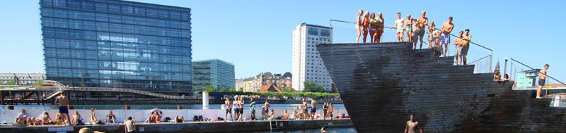


Copenhagen exemplifies innovative urban design solutions by transforming diverse range of spaces into vibrant public areas. Waterfronts like Islands Brygge demonstrate the city’s commitment to recreation and environmental revitalization. Plazas, such as Israels Plads, integrate nature and urban life, enhancing walkability and social connection. Streets like Sønder Boulevard prioritize inclusive spaces for relaxation, commuting, and recreation.
Cultural hubs, such as BLOX, seamlessly blend work, culture, and living, promoting creativity and collaboration. Even mundane spaces, like parking rooftops, are repurposed into multifunctional hubs, as seen with Park ‘n’ Play. These examples highlight Copenhagen’s holistic approach to designing public spaces that enrich urban life and build stronger communities.
Public Space Proposals on Friluftsliv
Examining the takeaways on our framework.
How We Make The Places
Positioning the three places onto the quadrants and creating a useful kit of parts.


In our framework, we identified three key study areas that reflect distinct spatial typologies:
1. The Waterfront Plaza adjacent to the TOD landmark building.
2. The Parallel Linear Space of the main commercial corridor.
3. The Small-Scale Community Pocket Park.
These spaces represent three types of urban environments within our design: a large-scale, highly social plaza, a dynamic commercial corridor, and a compact, intimate community park.
To better understand and shape these spaces, we developed a spatial sensory matrix. The matrix highlights how each space varies in scale, intimacy, and social function:
• The community pocket park is compact, offering an
intimate yet social experience for smaller gatherings.
• The commercial corridor is larger in scale, with a strong social focus and opportunities for vibrant activity.
• The waterfront plaza near the TOD landmark is expansive, a highly social destination that requires careful design to ensure comfort and inclusivity.
To bridge insights from our public space typology study into the proposal, we created a collection of urban design elements. These elements explore the nuanced strategies of placemaking, ensuring that each space fosters a sense of belonging, livability, and human connection while addressing functional needs.


Landmark Waterfront
Waterfront Plaza
Social and large public space that activate a center of gravity.
Social x Large
Section: key elements of a large public plaza


A waterfront landmark inherently serves as a focal point for circulation, activity, and interaction, accommodating large flows of people while acting as a key urban destination. Within our framework, we envision this space as an intersection of transportation, civic use, and entertainment, offering a dynamic and multi-layered experience for residents and visitors alike. To manage the scale and complexity of such a high-traffic area, we propose a clear spatial hierarchy that organizes programs, fosters accessibility, and softens the space’s potentially overwhelming nature. This approach ensures that the waterfront is both functional and welcoming, offering a humanized experience at all levels.`
Residential Pocket Park
Residential Pocket Park
Relatively intimate and compact space that serves for both residents and passerby.
Intimate x Compact


In residential areas, we propose a sunken park—a design that seamlessly blends functionality with spatial sensitivity. The sunken nature serves a dual purpose: it creates low-lying land for effective stormwater management, addressing environmental needs, while also fostering a distinct relationship with the surrounding residential buildings. This design allows people within the park to experience a gentle sense of visibility from nearby structures, fostering a feeling of safety and connection. At the same time, the sunken layout ensures that park visitors are not easily observed themselves, providing a sense of comfort and subtle privacy. This dynamic balance encourages visitors to respect the residential character of the area while enjoying the space.
Section drawing of the waterfront landmark space and its programs.
Aerial view of the waterfront landmark space and its potential layout.
Section: key elements of a community pocket park
Section drawing of the residential pocket park space and its programs.
Aerial view of the residential pocket park space and its potential layout.
Commercial Linear Corridor
Commercial Linear Corridor
A linear social space that serves mainly for commercial activation.
Social x Large (Linear)

Section: key elements of a commercial linear space


A linear space within a commercial area offers unique opportunities for vibrant urban experiences In our proposal, we explore a parallel doublecorridor approach one dedicated to vehicular lanes and the other purely pedestrian This configuration encourages free-flowing movement and interaction within the commercial environment while maintaining circulation richness and spatial flexibility


We recommend designing the vehicular lanes with textured pavement and gentle curvatures to create opportunities for pocket parks, loading zones, and areas of visual interest To enhance the user experience, segments of retail buildings should be intentionally interrupted with park spaces, providing breathing room and gathering spots for people to rest and socialize 25

Nørrebro. Source: HomeLike
The commercial corridor is envisioned as a vibrant, multifunctional linear space that supports movement, interaction, and leisure while maintaining spatial richness and flexibility. By adopting a parallel double-corridor approach, we create two distinct yet complementary pathways: one dedicated to vehicular circulation and the other to pedestrian activity. This configuration encourages free-flowing movement while fostering social engagement and creating opportunities for layered urban experiences. It becomes more than just a thoroughfare: it transforms into a destination that combines functional circulation, social interaction, and visual appeal. By integrating green spaces, fostering connectivity, and celebrating the canal’s presence, the design establishes a dynamic and adaptable public realm that encourages people to linger, explore, and connect.
In conclusion, Copenhagen provides an inspiring model for creating people-centered, livable, and functional urban spaces. Its typologies highlight the importance of balancing social interaction, environmental performance, and spatial adaptability to meet the needs of diverse users. Building on these principles, our design introduces three distinct spaces: a dynamic waterfront plaza, a vibrant commercial corridor, and an intimate community pocket park. Each space is carefully designed to foster a sense of belonging while addressing practical challenges, such as stormwater management, connectivity, and flexible public use. By integrating green spaces, enhancing connections to water, and prioritizing human-scale design, our proposal ensures that urban spaces are not only inviting and inclusive but also adaptable and effective for everyday life. This layered and thoughtful approach transforms the site into a place where people can gather, move, and connect seamlessly.
Section drawing of the commercial linear corridor space and its programs.
Aerial view of the commercial linear corridor space and its potential layout.

Appendix
REfshaleøen: REgenerate, REtain, REimagine
REfshaleøen
REgenerate, REtain, REimagine
Sources
1. https://www.independent.co.uk/travel/europe/denmark/copenhagen-city-guide-refshaleoensustainability-b2175598.html
2. https://issuu.com/annemadsbjerg/docs/transformation_of_copenhagen_harbor
3. https://byoghavn.dk/lynetteholm/koebenhavns-opfyld-og-hvad-det-bliver-brugt-til_eng/
4. https://www.e-architect.com/articles/copenhagen-harbour-architecture
5. https://www.lynchburgva.gov/513/Combined-Sewer-Overflow-System-CSO
6. https://loa-fonden.dk/en/projects/harbour-bath-at-islands-brygge-in-copenhagen/
7. https://mypathtotravel.com/copenhagen-swimming/
8. Copenhagen Media Center: Daniel Rasmussen and Martin Auchenberg
9. https://www.oenshave.dk/toursfarm-oenshave
10. Copenhagen Media Center: William Himmelstrup and Michael Gardenia
11. https://www.greeneconomycoalition.org/news-and-resources/people-power-denmarks-energy-cooperatives
12. Copenhagen Media Center: Thomas Høyrup Christensen
13. https://kbhkort.kk.dk/spatialmap
14. https://coastal.climatecentral.org/map/
15. https://stateofgreen.com/en/news/the-cloudburst-that-changed-copenhagen-and-urban-water-management/
16. Copenhagen Media Center: Daniel Rasmussen
17. https://danishdesignreview.com/kbhnotes/tag/Refshale%C3%B8en , https://reffen.dk/en/about/
18. https://arkitektforeningen.dk/arkitekten/enghaveparken-ad-gamle-og-nye-stier/
19. https://thebreakthrough.org/journal/no-15-winter-2022/blue-green-infrastructure-copenhagen
20. https://landezine.com/copenhagen-strategic-flood-masterplan-by-henning-larsen/
21. https://www.dezeen.com/2020/10/21/big-amager-bakke-power-station-hufton-crow/
22. https://autobranchendanmark.dk/nye-miljoezoner-i-kbh-odense-aarhus-og-aalborg-boer-ledsages-af-groenskrotpraemie-for-udtjente-dieselbiler/
23. https://klimakvarter.dk/en/projekt/tasinge-plads/
24. https://byoghavn.dk/lynetteholm/koebenhavns-nye-halvoe_eng-2/
25. https://byoghavn.dk/lynetteholm/kystlandskab-som-stormflodssikring-en-saerudstilling-om-lynetteholm_eng/
26. Copenhagen Media Center: Daniel Rasmussen
27. Copenhagen Media Center: Mellanie Gandø
28. Copenhagen Media Center: Lukas Bukoven
29. https://www.aiany.org/architecture/featured-projects/view/bq-park/
30. https://www.architects.org/stories/now-docking
31. Flickr: Henrik Pedersen
32. https://teateravisen.dk/teateroeen-lukker-ned/
33. https://danishdesignreview.com/kbhnotes/2023/5/15/vold
34. https://danishdesignreview.com/kbhnotes/2023/5/15/vold
35. https://dirt.asla.org/category/landscape-architecture/page/38/
36. https://travellingsunglasses.com/3-days-in-oslo-itinerary/
37. https://refshaleoen.dk/locations/move-copenhagen/
38. https://www.visitcopenhagen.com/copenhagen/planning/urban-rigger-student-housing-big-gdk1120565
39. https://www.cphvillage.com/refshaleoen
40. https://refshaleoen.dk/locations/havnens-haender-2/
41. https://secretkobenhavn.com/reffen-food-hall-copenhagen-street-food/
42. https://haven-dw.com/boardmill-block-park-building/page/2/?et_blog
43. https://inhabitat.com/stockholm-architecture-firm-joliark-converts-historic-brewery-into-a-light-filledheadquarters-for-octapharma/octapharma-brewery-renovation-2/ , https://thesun.my/business-news/batterseapower-station-in-national-geographic-s-20-best-cultural-spots-in-the-world-list-MF12069036
44. https://landezine-award.com/category/award-category/projects/page/19/
45. https://www.fastighetsbyran.com/sv/sverige/till-salu/stockholms-lan/stockholms-stad/objekt/?objektID=3055644
46. https://stock.adobe.com/search?k=%22islands+brygge%22&asset_id=459454379
47. https://commons.wikimedia.org/wiki/File:Aker_Brygge_(with_City_Hall).jpg
48. https://stateofgreen.com/en/news/the-cloudburst-that-changed-copenhagen-and-urban-water-management/
49. https://urban-waters.org/en/projects/tasinge-plads
50. https://byoghavn.dk/lynetteholm/kystlandskab-som-stormflodssikring-en-saerudstilling-om-lynetteholm_eng/
51. https://byoghavn.dk/lynetteholm/kystlandskab-som-stormflodssikring-en-saerudstilling-om-lynetteholm_eng/
52. https://www.thelocal.dk/20240221/danish-report-outlines-rising-storm-surge-threat-to-copenhagen
53. https://copenhagenize.com/2015/03/the-copenhagenize-current-stormwater.html
54. https://www.visitoslo.com/en/activities-and-attractions/boroughs/aker-brygge-tjuvholmen/
55. https://www.weissmanfredi.com/projects/15-hunter-s-point-south-waterfront-park
56. https://www.rehwaldt.de/projekt.php?proj=ZWI&lang=en
57. https://www.tredjenatur.dk/en/portfolio/enghaveparken-climate-park/
58. Copenhagen Media Center: Astrid Maria Rasmussen and Daniel Rasmussen
59. https://landezine-award.com/chulalongkorn-university-centenary-park/
60. https://livingarchitecturemonitor.com/articles/sterbro-klimakvarter-the-first-climate-adaptation-neighborhood-indenmark-fa23
61. https://www.cobe.dk/projects/nordhavn

