
about Site about Studio
The relationship between the water edge and the city is often problematic as it connects high-quality natural systems from the urban sprawl. The homogenous nature of riverfront development design projects tends to lose the visual imprint of experiences that riverbanks and edges have had. It also lacks in connecting people’s past associations at varied points along that landscape. The developmental approach towards land-water mediation is greatly influenced by the political system in which we operate; the economic use we see for land; our aesthetic preferences; and our social conventions.
In most examples of riverfront development, river water is canalized, by means of constructing hard edge. This breaks or discontinues flow of water and in-stream ecology. Designers design these urban spaces, while ecologists and landscape designers counter the decisions made during the design process. What misses out in this process is the negotiation between land and water. This studio questions the monotonous treatment of the riverfront and the ways of designing at the intersection of land and water.
The studio proposal is developed along the river continuum theory – where the patters and process along the RIVER MUST CONTINUE…and it is non-negotiable. This exhibition is of Module 1, which was adapted from Christophe Girot’s “Four Point in Landscape” Landing, grounding, Finding, Founding (using a landscape framework for site assessment and analysis).

Students
Faculty
Special thanks to
Charan V Priyanka Kanhare Vaishal Patel
Garima Sinha Parth Patel (Teaching Associate) (Photogrametry Data)
Ketki Sandeep Nandanwar
Patel Kanisha Kalpeshbhai
Rajeev Rajesh Bhagat
Rishabh Jain
Shrayana Ray
Simran Khatter
Sneha Ramachandran
Teesta Singh
Zankhna
The Vishwamitri river originates in the western and southern slopes of Pavagadh hills. It travels through the city of Vadodara before joining two additional tributaries, the Dhadhar and Jambuva, further down the river, where it eventually reaches the Gulf of Khambhat. The river is a 220 km long stretch which has a distinctive habitat that is home to numerous ravines from the beginning to end. The presence of the Indian crocodile, a highly protected species, is of utmost significance to its ecology. For thousands of years, these crocodiles have lived and reproduced in an 18 kilometer stretch of the Vishwamitri River.
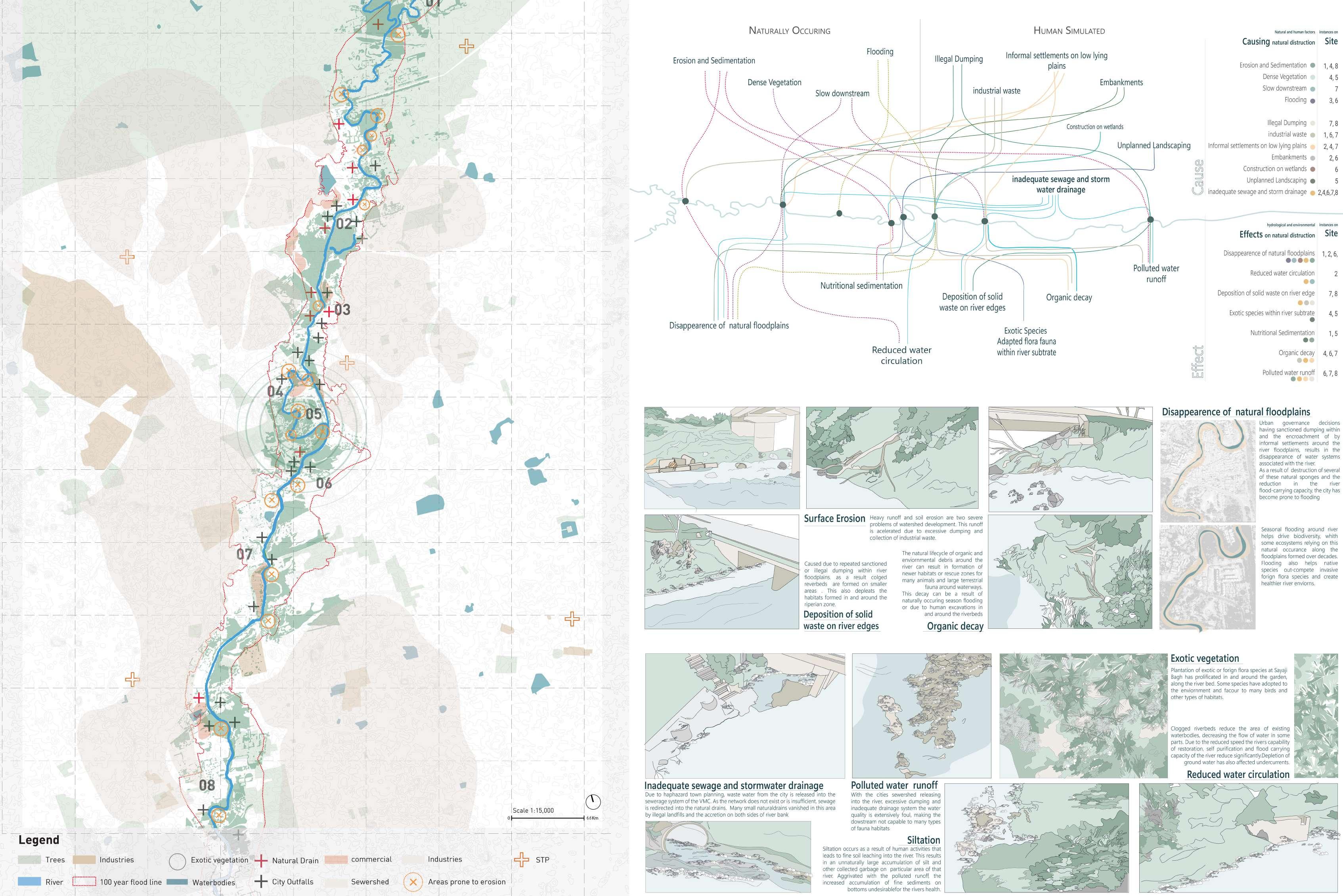
Due to the rapid development and disregard for water systems inside the city and its surroundings, the river has experienced serious abuse over the years of its passage within the city of Vadodara. Sewage, polluted storm water outfalls, industrial effluents dumped into the river, as well as other point and nonpoint sources of pollution, have all caused constant ecological harm to the area.
transect
Study observe and record
01a Landing
The focus of this exercise is to observe and documenting existing conditions of site “Landing”, the first impression.
Based on the theoretical premise mentioned in “Four point Trace” by C. Griot –Landing (first impression and prejudice), students will be made to record and analyse manifestation and their interconnectedness along the riverine landscape, with focus on what has the kept the river continuous. Recording the first impressions of site.


transect Study observe and record
01b grounding
The focus of this exercise is to draw the existing conditions of site as it is – “Grounding”, Actual onsite conditions.
Based on the theoretical premise mentioned in “Four point Trace” by C. Griot –Grounding (Actual on-site conditions), students will be made to record the multiple layers of the site, both visible and invisble. Through the site visit and literature studies, the students will have to document the context in form of soil, water, ecology, culture and history.


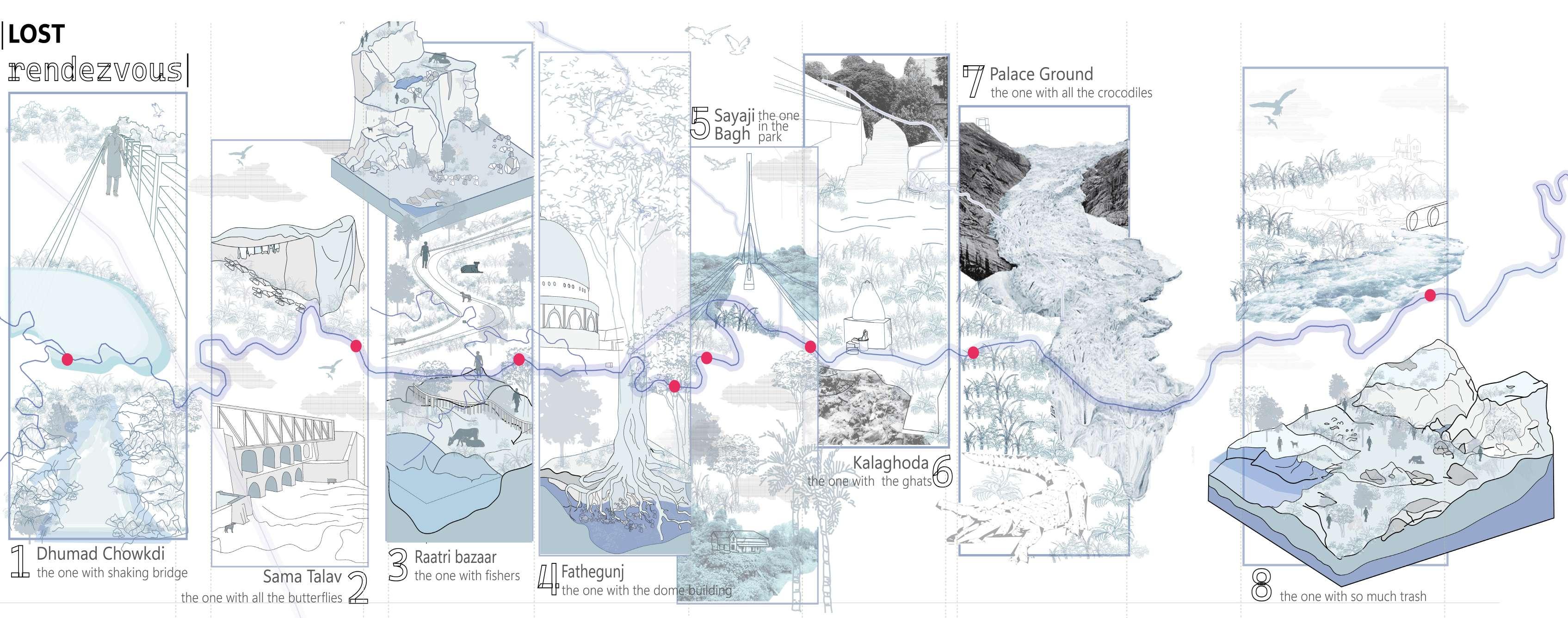
5.a the river’s richest biodiversity | Location: Sayaji Bagh

This part of the river flourished with a its original palette of plantation including native plants and plants that were planted for the garden landscaping. Many trees near the shore were seen sheltering flocks of eagles searching for their prey on the river edge. It is also the deepest point of the river in the city.


7. The river’s naturally thriving crocodile habitat | Location: Akota Bridge


The Crocodile Habitat shelters multiple crocodiles. A high deposition of solid waste is observed on the river edge, with multiple crocodiles residing on the heaps of garbage created by the sewage drains. The grain of the landscape here is very dense, covered with many native flora species.

8. The river’s depart from the urban fabric | Location: Near Khishkoli Circle


This site features undulating landscape on one edge. Water is seen making its way through the landscape giving it a relatively rugged edge and caters to naturally grown native plants on both the edges. The water quality decreases substantially till this point with high levels of polluted runoff from the city.

Finding and Founding 02 analysisand inferences
The focus of this exercise is to draw inferences and insights from information collected through grounding– “Finding and Founding”, (Inferences and insights).
Based on the theoretical premise mentioned in “Four point Trace” by C. Griot –Finding and Founding (Inferences and Insights), students will be made to bring their own understandings and inferences that may change and redirect a particular site. Examples range from the placement of new object, framing a new point of view, to simply changing the use of a particular place.
deconfiguring Habitat Complexity
Finding Biodiversity Hotspots


design Strategies
Collective investigation and inferences
The focus of this exercise is to develop guidelines and report for efficient design along river corridor, by following river continuum approach
Students will develop a detailed design proposal for a chosen site area, which will be supported by conceptual diagrams and a design program. Area calculations and the appropriateness of spaces will be detailed.
Along with the above, students will continue working on the designed and developed detailed proposal for zoomed in areas at 1:1000, 1:500 and 1:250 scale
the Neglected river
Weaving the unsown parts of an ecosystem


Vishwamitri river is one of the main features of Baroda. Although it cuts the city through its centre, the river remains neglected by its citizens. It is confused by the people to be a drain instead. This has happened because of the way the river has been treated by the city for years, dumping most of its sewage in it. The edge of the river can be recognised by the untouched greens adjacent to the river. Even though the water of the river is extremely polluted, the edge has managed to maintain a very strong ecosystem
The project aims to enhance the now-neglected river and restore its identity by increasing human interaction on the edge. It does this by connecting the people of the city to the three elements that make up the ecosystem - the flora, fauna and water. The intervention aims to achieve this by retaining the vibrant experiential quality of the vegetation patterns along the river edge. The fauna of crocodiles and snakes makes the edge dangerous to access. Yet, the intervention makes minimal physical connection while curating multiple vistas and introduces activities such as an aviary to engage with the river.

Plan analisys Zone 1
Plan analisys Zone 2
Masterplan - Site selection and Zoning


Zone - 1 Plan
Zone - 2 Plan and Section


