
6 minute read
A vision for a resilient and vibrant chicago


The legacy of the Great Lakes Region is one of ecological abundance which has been challenged and disrupted by industrial and urban primacy. Fragmented natural systems need to be restitched to restore Chicago region’s legacy of rich natural systems, promote coexistence between humans and nature, and catalyze Chicago’s New Nature - an ecology that responds to historical degradation and is innovatively positioned for urban use and resilient climate adaptation - through design, planning, and governance.
Ecologically fragmented chicago
Advertisement


Chicago’s New Nature
1.28 million people living in the ‘C’ impacted by Chicago’s New Nature of new green space across the Green Roof Network


14,000+ acres of remediated and rewilded land
12,500+ acres of newly connected ecological corridors


2,000 miles
Community Design Engagement
Our 35th
AN URBAN DESIGN PLAN FOR 35TH STREET, MCKINLEY PARK

MCKINLEY, ILLINOIS PROJECT LOCATION :
ROLE : WORK :
ACADEMIC (GROUP)
RESEARCH, CONCEPT, DESIGN, DRAWINGS, RENDERS, GRAPHICS
SEMESTER :
GUIDE :
MCD - SUMMER SEMESTER 23’
DR.APRIL JACKSON
DR. SEVIN YILDIZ
MERAV ARGOV
// Urban Design
// Planning
// Research
// Community
// Street Redesign
// Landscape
// Mixed-use
// Sustainability
// Prototyping
The 35th Street corridor is foundational to McKinley Park’s identity of community, culture, and resiliency. This project builds upon these values and fits within a larger, coordinated effort to make 35th Street better for all McKinley Park residents. In partnership with the McKinley Park Development Council (MPDC), Bridgeport Alliance, Coalition For A Better Chinese American Community (CBCAC), and international consulting firm Design Workshop, the UIC College of Urban Planning and Public Affairs Master of City Design program facilitated a community-led design process for a comprehensive corridor plan for 35th Street between Leavitt and Ashland.
GIS, InDesign, Illustrator, Photoshop, SketchUp, Vray
INCLUSIVITY:
Respect the neighborhood’s heritage and cultural identity
Project Principles
IMPROVED MOBILITY FOR WALKERS AND BIKERS:
Prioritize pedestrian and bikers safety through protected bike lanes, proper street lighting and active storefronts
Our 35th
ENHANCED COMMUNITY INTERACTION and ENGAGEMENT:


Engage and collaborate with the local community
Process
LOCAL ENTERPRISE PROMOTION:
Create opportunities for diverse small businesses, local entrepreneurship, and cultural amenities
Concept
35th as a Neighborhood Main Street
The design concept conceptualizes 35th Street as McKinley Park’s bustling street with concentrations of activity at certain intersections from Archer to Ashland. Based on community feedback, the concept integrates elements of artactivated alleyways, a linear park, extended sidewalks, community spaces, pedestrian crossings, and food trucks. These strategic additions can help promote small business development and community well-being.


The 35th street will transform into the “Neighborhood Main Street”, becoming the go-to-destination for McKinley Park. The new street design promotes accessible and safe pedestrian mobility for pedestrians and cyclists. It expands dining and shopping options, as well as comfortable, outdoor spaces for people to gather and celebrate their community.
Through past planning efforts, the 35th Street corridor has been identified as a catalytic site for community and small business growth. In addition to conducting preliminary research on the corridor, our team organized engagement events at different neighborhood sites where community members gather, play, and work. These events led up to a design charrette, which brought together diverse community members to co-create ideas for improving the corridor. As the culmination of our research and community engagement, this project leverages existing assets, celebrates the neighborhood’s cultural diversity, and furthers connectivity and inclusivity.
Our Vision
The 35th Street corridor is McKinley Park’s vibrant, community-oriented main street anchored by strong local businesses, multimodal connectivity, and resilient infrastructure.


‘The Portal’ 35th and Archer
The 35th and Archer intersection connects McKinley Park to the city through the CTA Orange Line and other transit options. Based on community feedback, this transit oriented development is a potential portal into and out of the neighborhood. The view shows a part of the parking lot being repurposed into a linear park to improve walking and biking connectivity surrounded by grab-and-go businesses. The sidewalks at the junction are extended, and the paving is modified to facilitate traffic calming. These interventions also respond to safety concerns related to road accidents, improving mobility around the L station.

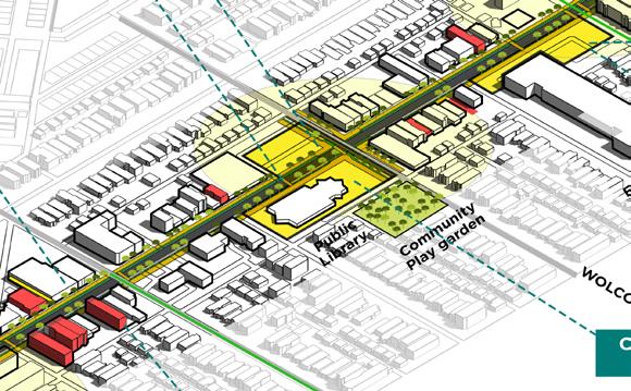
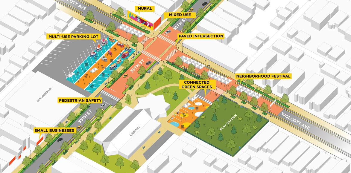
‘Social Hub’ 35th and Wolcott Ave
Housing the McKinley Park Library and the Walgreens store, this intersection is frequently visited by community members. The junction is envisioned as a “Social Hub” with multiple small businesses and flexible gathering spaces.
It repurposes the Walgreens parking lot as a station for food trucks with an extension into the library’s landscaped space. Wolcott Avenue is utilized as the Festival Street, which can host small street markets and block parties spanning 2 blocks in either direction from the McKinley Community Play Garden.


‘The Heart’ 35th and Wood St
Adjacent to the Nathanael Greene Elementary School, the 35th and Wood intersection becomes an essential community space hosting a seasonal pop-up playground for all ages and a temporary performance area. Displaying the neighborhood’s diversity through public art on empty facades and providing space for cultural celebrations, the intersection embodies the heart of McKinley Park. Also, the bike lane on 35th Street links to the proposed bike network on Wood St, which stretches to the large park through 37th St. This redesign encourages casual meet-ups and community connections, while becoming a platform for cultural expression.
Urban Design
// Urban Design
// Planning
// Research
// Form Based Coding
// Prototyping
// Landscape
// Community
// Sustainability
// Mixed-use
Madison For Everyone
03 Blurring Edges
OAK PARK, ILLINOIS PROJECT LOCATION :
SEMESTER : ROLE : WORK :
GUIDE :
ACADEMIC (GROUP)
MCD - FALL SEMESTER 22’
This design project aims to propose solutions for revitalizing the commercial corridor of Madison Street in Oak Park, characterized by high vacancy rates and a drive-thru economy. The focus is on a 1.5mile stretch of the street between Harlem and Austin in a metropolitan region with diverse urban edges and socio-economic disparities.The goal is to blur the hard edge between Oak Park and Austin and activate the street’s commercial activities and character. Madison presents a unique opportunity to serve as a “community connector” between neighboring communities and within Oak Park itself. The project explores creating new identities for Madison, such as Madison-Med, Mix, and Made.

Planning Making Process and Methord
The approach involved a research-informed methodology, with community input informing the direction of the project. Statistical data was utilized to support tangible design approaches, while experts in specialized fields were consulted to gain a better understanding of the area
Context
Initial Insights 01
Data gathered through a self-guided tour of the communinty, helped us guide investigations into local histories and people that animate madison.

Community Profile 02
It revealed the development trends, housing patterns, and transportation connections for considerations on Madison
Spatial Analysis 03

A closer look at Madison revealed additional asserts, opportunites and spatial charateristics to be addresses on the corridor.

Concepts, Criteria, and Constraints
By defining the problem, identifying opportunities for design repairs and setting a scope of work, the studio laid the groundwork for a comprehensive design
Oakparkavenue
Design Proposal 05
Work for the design proposalbegan by establishing collective design values and vision. “Madison for Everyone Else” came together.
Community Profile
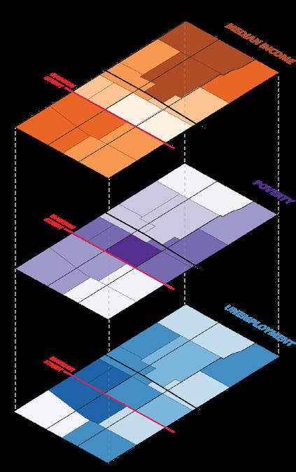
An analysis of the census tracts surrounding Madison reveals that they have the lowest median household incomes, highest poverty rates, and highest unemployment rates in the community. Additionally, the western end of Madison is characterized by the lowest housing values, moderate rents, and high residential density.
Transect Analysis
Zooming out from Oak Park, the transect analysis shows how the Madison corridor transforms from a downtown urban artery (and the start of Chicago’s North/South numbering system), to a newly developed commercial and office strip in the West Loop, and eventually transitioning into a neighborhood corridor.
Vision: Madison for Everyone else
Oak Park is headed towards a lack of affordability shown through high property taxes and increasing rents.
Madisonstreet
Oakparkavenue
Lack of concentration of retail on Madison Street contributes to its status as a stagnant economy.
The absence of a historic district and preservation sites along Madison Street results in a lack of identity for the corridor
Key Takeaways
Madisonstreet
Madisonstreet
Oak Park is headed towards a lack of affordability shown through high property taxes and increasing rents.
Madisonstreet
Lack of concentration of retail on Madison Street contributes to its status as a stagnant economy.
Madison Street has a lack of pedestrian infastructure, the streetscape doesn't as to support community building.
Oak Park is headed towards a lack of affordability shown through high property taxes and increasing rents.
Lack of concentration of retail on Madison Street contributes to its status as a stagnant economy.
The absence of a historic district and preservation sites along Madison Street results in a lack of identity for the corridor
Madison Street has a lack of pedestrian infastructure, the streetscape doesn't as to support community building.
Oak Park is headed towards a lack of affordability shown through high property taxes and increasing rents.

