"SITOPIA" LEUVEN Creating a Landscape Mosaic of Food Infrastructures Leuven Area, Belgium Raya MasterRizk(of Science) Urbanism, Landscape and Planning Faculty of Engineering and Department of Architecture Promoter: Prof. Bruno De Meulder - Co-Promoter: Prof. Kelly Shannon Academic Year 2021 - 2022


Academic Year 2021 - 2022
Leuven Area, Belgium
"SITOPIA" LEUVEN
2 3
Creating a Landscape Mosaic of Food Infrastructures

Promoter: Prof. Bruno De Meulder - Co-Promoter: Prof. Kelly Shannon
Raya MasterRizk(of Science) Urbanism, Landscape and Planning Faculty of Engineering and Department of Architecture
permission of the thesis supervisors is also required to use the methods, products, schematics and programs described in this work for industrial or commercial use, and for submitting this publication in scientific contests.
Thank you to the ICoU and MaHS/MaULP family, who have shared an unforgettable and unprecedented experience throughout the last two exceptional years. The bonds created here are truly strong and long-lasting! In particular, a big and heartfelt thank you to my thesis partners, Laetitia Hanna and Bing Du, for the endless motivation and many discussions.
To my parents and sister Rana, your endless love, support, and motivation have not failed me once and sustained me throughout this journey! You have always been there for me, and I am forever
Sana and uncle Bashir, my second parents, thank you for giving me a home away from home; and contributing to enriching my thesis!
For a final note of gratitude, I would like to take the time to mention every person who has contributed to the development and success of my thesis. Without every single one of you, my work would not be as rich and
AHeverlee.written

© Copyright KU Leuven


Acknowledgmentscomplete.
Tograteful!myaunt
I wrap this thesis with appreciation and gratitude for all the endless knowledge, support, and guidance I have received throughout this Firstly,process.I
4 5
DEPARTMENT ARCHITECTUREOF
Without written permission of the thesis supervisors and the authors it is forbidden to reproduce or adapt in any form or by any means any part of this publication. Requests for obtaining the right to reproduce or utilize parts of this publication should be addressed to Faculty of Engineering and Department of Architecture, Kasteelpark Arenberg 1 box 2431, B-3001
would like to start with my promoters, professor Bruno De Meulder and professor Kelly Shannon, for your careful guidance, insightful knowledge, and continuous challenges beyond my comfort zone. I would also like to extend my gratitude to the external readers, Richard Plunz and Lyne Jabri, for following along this academic year and for all the insightful conversations.
6 7
Every year in Belgium, on average 2.5% of the houses and 3% of the agricultural plots are changing ownership and subsequently very often drastically transformed (Platteau et al. 2018; Vlaamse Regering 2020). These numbers attract a significant number of real estate agencies, using the loss of interest of farmers in agriculture, or the lack of successors in the family, to their advantage. This is creating a great shift in the urban and landscape fabrics. However, these statistics and outcomes are only from the real estate/land tenure perspective.
Through these two windows, I am investigating how to create Sitopia more elaborately through the development of the food landscape as the underlying infrastructure. Thus creating Sitopia through the development of tools to mark circular food production as the new infrastructure for growing urbanization.
The northern part of Leuven has historically been a main vegetable basket of Flanders in general and still is the vastest agricultural “zone” in Leuven. It is not accidental that historically food processing industries like the Maritumas originated here. For this reason, it seemed natural to start creating Sitopia in that area. In this thesis, I will experiment with developing Sitopia in two different zones, each are uniquely embedded into its context.
Sitopia means city of food, meaning the aim of this project is to develop a new food landscape to serve as a primary infrastructure for the city of Leuven, starting from the surrounding municipalities. The vision creates a mosaic of new and more diverse agricultural methods. This mosaic is incrementally and gradually implemented through the method of pooling parcels. Pooling and subsequently rearranging the land layout is only an in between step before reaching the eventual “Sitopian” mosaic.

The first area of study in Herent is a ribbon development that breaks through a primarily agricultural area. The second area in Wilsele, a small river tributary along with a barcode of open spaces breaks through a somewhat ‘dense’ suburban fabric.
So how do we re-visualize this movement into a dynamic opportunity to trigger Sitopia? It would be by using these numbers to our advantage, starting small and gradually pooling parcels – whole or partially –until eventually reaching Sitopia.
Long, narrow plots encroaching into agricultural plots
Leuven, Business as Usual Research Question & Methodology
Seeking Sitopia | Conditions and Opportunities
Wilsele: Barcodes of Greens, Orange and Blue 787659412711612141618202225283842444648505254566068
Design Vision, a Glimpse of "Sitopia" Leuven Leuven, a Lost Sitopia
Shaping Sitopia | Design by Experimentation
8 9
From Lessons Learnt to Design Toolbox Pooling Strategy
Implementing Sitopia | Site-Specific Interpretations
Sitopia in Theory Personal in Practice
Sitopia | Definitions & Evolution
Sitopian Choreograhy Food Landscape Strategy Water System Strategy Housing Strategy
Sitopia | Definitions & Evolution
10 11
©
12 13
I borrow the concept of Sitopia as used in Carolyn Steel's 2011 book Hungry City: how food shapes our lives. The word originates from the greek 'sitos' and 'topos', which mean food and place respectively. Throughout her work, Steel has emphasized the importance of bringing these two concepts back together, and to mobilize their potential to reconfigure our lives and cities more positively.

© Screenshot of TED Talk video https://www.greenrabbits.org/what-is-sitopia
Sitopia in Theory Sitopia Hypothetically

www.sitopiafarm.com/©
Sitopia(www.www.sitopiafarm.com/)Agriculturaurbana
Thoughts & Interpretations
Sitopia Agricultura urbana Mexico City, Mexico
14 15
Sitopia Farm Greenwich, South East London ,UK
The Sitopia Farm is a project best described as a social enterprise, with Carolyn Steel as chair member. The project aims to educate and raise awareness of the social, environmental, and health advantages of Sitopia, apart from growing local and sustainable food. Initially based in two small locations in London, Sitopia Farm then expanded to an area of 8m² located in Greenwich. The methods used for growing the food are ecological by regenerative agricultural techniques, which make the project stand out.
Sitopia in Practice
Sitopia Farm aims at making a social impact as it brings people together. Numerous community activities are organized, such as workshops, community feasts, open days, and engaging schools. The goal is to grow more local food in London and inform about the crucial changes required in the food system.


However, these hands-on deck examples are still on small parcels of land, despite reaching a wide range network both physically and digitally. One is triggered to experiment and interpret their missions, triumphs, errors, and feedback on a larger scale. Therefore interweaving these lessons with (sub) urban fabrics and possibly multiplying the success rates. And that is the purpose of this thesis design research project.
Sitopia, an urban regeneration project, started in 2016. The goal is to inspire and promote urban farming. The main aim is to grow food within the urban environment of the city. The project uses agriculture and food production as a way for the people to (re)connect with nature, with the ambition of creating more producers than consumers. It is an attempt to restore the relationship of the residents of Mexico with their food. At the same time, the sources of food are rescued while the production processes are continued through a holistic connection. The latter creates a whole new healthy and sustainable interaction. The original concept came from 5 women who built a garden on the terrace of a building and soon afterward discovered the secret of Sitopia. Since then, the project has developed various workshops and educational programs and offers classes about urban farming, gardening, and urban composting. (www.sitopia.mx)
There is a lot to learn from these established projects. Their ability to adapt to their respective growing communities while keeping the integrity of their original mission is testimony enough.
Sitopia Farm Greenwich, South East London ,UK
"An urban community shaped through its food sitopia.mx), in-person workshops, and


www.sitopia.mx©
Mexico City, Mexico
There are not many real-life examples of Sitopia today. These two projects here are some of the few that you can find. I believe both can attribute their popularity and success to their mutual vision: to create a wide range of communities. They do not restrict themselves to the property limits of the land but through their online platforms. In fact, we can refer them as Sitopian meccas.
16 17Leuven, Today Design Vision, a Glimpse of "Sitopia" Leuven 2022Earth,Google© Sitopia, 2100


Leuven, a Lost Sitopia
"Louvain à la fin du XVIème siècle", gravure. Traces of a productive past 1850-1900.A..,Joos,© Leuven Region in the late 18th century, inspired from Ferraris 1777-79 map series. 0 0.5 1 2 kmPonds (Water collection and Fish production) DomainsHousingCanalRiver (Abbeys and VehicularCastles) Infrastructure Agricultural fields EvergreenForage forests Kitchen Orchardgardens
Even depicted in the image below from the late sixteenth century, food production was simultaneously at the forefront and center of this city’s life. Some landmarks remain tactile testimonies of the past, all of which have become recreational market squares.

18 19
The map represented here is based on the Ferraris map of Leuven drawn in the late eighteenth century. We can distinguish food at the core of the entire Leuven zone, be it within or beyond the walls of the fortified city. The vast agricultural lands are interrupted by forage areas along the river and within the floodplains. Kitchen gardens were necessary commodities for most if not all households along every primary route and market gardens took up a vast area within the fortified city. Every domain and abbey had an elaborate food production system, including extensive fish farms and orchards. Leuven was, without a doubt, a true Sitopia.
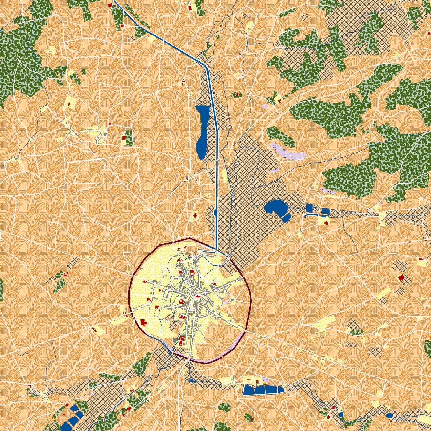
As we can see in the plan on the right, Leuven no longer looks like the Sitopia of the 16th and 17th centuries depicted previously. The productive abbeys are currently recreational, and the fish ponds are no longer active, indicating the food is no longer at the forefront. Over the years, agricultural fields were gradually pushed outside the city, and the kitchen gardens are in some designated areas. As for animal foraging and fruit orchards, they were scattered patches across the Leuven zone. Leuven is a city known for its university students, growing young families, and senior residents. Thus, the local and visiting communities are increasing the demands on housing both short term and long term.
Leuven Today
Ponds (Water collection and Fish production) DomainsHousingCanalRiver (Abbeys and Castles) Agricultural fields Evergreen forests Kitchen gardens

Open spaces, prime real estate locations


20 21
Leuven Region today.

InfrastructureVehicularRailway
0 0.5 1 2 km
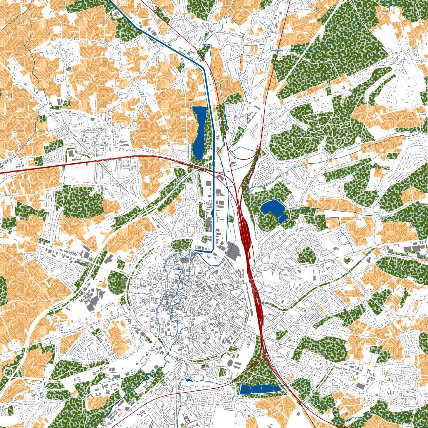
Leuven, Business as Usual
My hypothetical scenario if Leuven continues business as usually, ie allowing 2.5% of houses and 3% of agricultural fields to sell every year (Platteau et al. 2018; Vlaamse Regering 2020): Leuven could look like the plan on the right. This scenario is not too far from reality as it potentially could become a reality in the next 50 to 100 years. This timeframe is significantly tangible in its Additionallyproximity.to these housing expectations, the current food trading is undergoing significant pressure. For these reasons, I challenge these numbers, this scenario, and the external food dependency by experimenting with design tools as an alternative to the growing community by shifting the infrastructural focus toward food landscapes. Ideally, the new food landscape infrastructure would eventually lead to food autonomy.

Leuven Region hypothetically taken over by real estate projects. Ponds (Water collection and Fish production) DomainsHousingCanalRiver (Abbeys and Castles) Agricultural fields Evergreen forests Kitchen gardens InfrastructureVehicularRailway 0 0.5 1 2 km


22 23
Hypothetical scenario

This thesis attempts to establish a framework within which the (sub)urban food culture that did exist in certain historical contexts can be re-introduced by redefining the manner in which its infrastructure operates - through including the development of communal goods and the growth of a sense of community. Ultimately, the framework could underpin the sustainability of a micro-circular
How can Leuven’s past food network be re-animated and transformed to propose urban food as a new infrastructure?
Thiseconomy.thesis
develops design research to experiment with the creation of contextual “Sitopia” 's in the Flemish context. Throughout the study, I develop site-specific tools to mark circular economy food production as the new infrastructure for growing urbanization.
What are the steps to achieve Sitopia?
Research MethodologyQuestions
24 25
26 27
Seeking Sitopia | ConditionsOpportunitiesand
The riparian corridor flows from the South in Heverlee, into the center between the distinguished land formations, and continues in the Northern agricultural plain. From the South, we find a high plateau, contrasted by a low plateau on the Northern side. Two sets of "witness hills" lay on the East and West as a live testimony of the Ice Age. between


28 29

Mound Bound Leuven
Nestled
hills and plateaus DrodgedPonds NaturallyRunoff5NaturalChannelizedCanalRiverRivermTopographyFloodSubmersible databaseVlaanderenandgeopuntfromAdapted© 0 0.5 1 2 km

Forced out of the city into the suburbs Low WitnessPlateauMounds Witness Mounds HighFloodPlateauPlain Agricultural Fields Animal NaturalChannelizedDrodgedPondsGreenParksNatureGardens/GrassForagingReservesInfrastructureCanalRiverRiver databaseVlaanderenandgeopuntfromAdapted© 0 0.5 1 2 km


Threatened Open Spaces

30 31
With all of the threats that these open spaces are facing, it is important to focus on the existing assets to start reinforcing them and eventually building a new foundation: Soil, Water, Existing agricultural practices, Surrounding, and Context
Absorption & Runoff
The rainwater is mainly collected naturally in the floodplain and at the foot of the slopes. However, the type of soil on the left side of the canal could potentially help create some rainwater collection and phytoremediation. Thus, equally distributing the water across the terrain using the soil variety to our advantage.
0 100 250 500 m
32 33
ClayTurf
Unequal rainwater distribution databaseVlaanderenandgeopuntfromAdapted©

Light Sandy Silt
Drodged Canal Submersible
Silty Sand Runoff FloodSandySilt Silt
Naturally
34 35
Fertile soil, strong Sitopia foundation databaseVlaanderenandgeopuntfromAdapted©
Light
Sandy Silt Silty Sand Agricultural FieldsSandySilt Silt Forested Areas 0 100 250 500 m

The remaining fertile soil (silt) seems strictly dedicated to the agricultural land and forested areas. The significant white gaps represent the manipulated or imported soil for the old housing and new construction. Real estate development keeps growing, and more horse ranches are taking over. These threats are visibly increasing in surface area.

Thinking like a Plant
ClayTurf
36 37
Intensive Monocropping
The legend here implies a good variety of agricultural practices in theory. However, studying how it looks on the ground clearly shows intensive monocropping. Having 3% of agricultural lands sold every year (Platteau et al. 2018) is a strong indicator of its failure. And despite having some community-supported associations (CSAs), they still do not create an impactful change at this scale.

Restriction in diversity, restriction in productivity databaseVlaanderenandgeopuntfromAdapted© VegetablesGrains,PotatoesSeeds, SugarCorn Beets GrasslandInfrastructureAgricultural Animal Forage Other Crops Vegetables and Herbs Forested Areas 0 100 250 500 m
38 39 Areas of Study 1. Herent: Long, narrow plots encroaching into agricultural plots 2. Wilsele: Barcodes of Greens, Orange, and Blue Combinations of infrastructure and surroundings databaseVlaanderenandgeopuntfromAdapted© Agricultural Fields Animal Foraging InfrastructureGreenParksNatureGardens/GrassReserves DrodgedPonds Canal Natural River 1. 2. 0 100 250 500 m


Shaping Sitopia | DesignExperimentationby
40 41
42 43 Parc du Sausset By Michel Corajoud Location: Aulnay-sous-Bois, France Area: 202.6 ha Year: 1980-2005 Parckfarm By Alive Arhitecture / Taktyk Location: Brussels, Belgium Area: 3 ha Year: 2014-2015 Coro Field By Integrated Field Location: Suan Phueng, Thailand Area: 1,345 m2 Year: 2015 Little Forest Garden By Location:HEA Seognam, Korea Area: 100 m2 Year: 2019Taktyk/ArhitectureAlive©http://corajoudmichel.nerim.net/© WongwanKetsiree©©2021.HEA Case Studies The Brick Yard 33 1/3 By Motif Planning & Design Location: Taipei City, Taiwan Area: 1,586 m2 Year: 2014-2017 Le Bel Hellouin Farm By Perrine & Charles Hervé Location: Le Bec Hellouin, France Area: 20 ha Year: 2012 - ongoing Grand Laval Farm By Sebastien Blache & Elsa Gärtner Location: Montélier, France Area: 3 ha Year: 2006 - onging BismarckhöheGartenbauverein By Community of Scharpenberg Location: Mülheim, Germany Year: 1948- 1988Fermedubec.com/©designHC,TsengYiShu,KuoMonica,HoPin,WuShuyuan© Kgv-bismarckhoehe-muelheim.de/©Facebook.com/legrandlaval/©


44 45
From Lessons Learnt to Design Toolbox
- They eat production surplus and reduce waste
Activities revolving around food always brings people together as a community: growing plants, sharing ideas, cooking together, exchanging thoughts and experiences, and more.
Food Production
Parc du Sausset LittleCoroParckfarmFieldForest Garden The Brick Yard 33 1/3 Le Bel Hellouin Farm Grand Laval BismarckhöheGartenbauvereinFarm ProductiveTrees FoodasCommunity Binder FoodasCommunity Binder ClosedWater System AnimalHusbandryClosedWaterSystem Educational Spaces FoodSereigntyClosedWaterSystem ChallengePerceptions on FoodProduction
Closed Water System
Animal Husbandry
Challenge Perceptions on Food Production
- Invert the perception of food production by making it the infrastructure and weaving in services such as cafes, restaurants, schools, retail, and more.
- A space to teach all generations new and practical agricultural techniques


Flexibility and Adaptability
The design framework and details should be flexible enough to adapt throughout the extended timeline and its core integrity.
Food as a Community Binder
- Incorporate crops such as herbs and small fruit trees as part of the communal and gathering spaces.
- Transforming agricultural fields and allotments into destinations instead of blending within the scenic landscape.


- They graze and prune the trees
- Encourage seed sovereignty by creating a program of collecting seeds and planting them in the following seasons.
- Allow enough space to diversify and combine different productive species to yield more quantities and diversity.
- Food production and allotments could easily be integrated within the design scheme instead of being tucked away in the corner of the projects.


A complete water system is circular and self-sufficient and includes: Rainwater Collection, Bioswales, Increasing infiltration, Ponds, and more.

- A space accessible for people with disability.
Animals help enrich the food production cycle:

- Their manure can be used as organic fertilizer
Educational Spaces
46 47
The water system is the main element linking all the mosaic patches as it collects, processes, and re-distributes water across the terrain.
XS: Water as a Connecting Infrastructure
Pooling Strategy
L: Intensive Production Patch:
M: The Intermediary Production Patch


Process of making food landscapes a new ForinfrastructureSitopiatobesuccessful,

MosaicBlockCurrentPoolingSituationPooling 0 5010 100 m
it should be developed gradually, incrementally, and over several milestones. Pooling is likely to be an optimal method to implement it, as we can start at a small scale. The long and narrow plots are characteristic of the Flemish region. Upon closer examination, I noticed that most of them are either planted with trees or are unmaintained grass areas. Thus, making them potential starting places for the pooling method.

The mosaic contains four categories, each with its particular nature:
The plant nurseries are essential for keeping Sitopia running throughout the years. These nurseries sustain the mono-crop fields, orchards, agroforestry, and natural forests. S L L Plot
M M
S: The Community Patch
The residential patch focuses on the community, a space for the dwellers to enjoy common commodities such as eco pools, sports fields, playgrounds, and more.
The area is an in-between production level, where the communities have access to their allotments, helping with the orchards, cafes, and restaurants, educational and exhibition spaces.
The idea of pooling parts of private land parcels together has the advantage of creating a new type of semi-private space. This strategy allows the shared owners a larger piece of land they did not previously access. This new pooled space allows for a larger variety of crops and yields more vegetables and fruit trees. As a second step, these new parcels are pooled a second and third time until obtaining a mosaic.
The planting scheme in Sitopia happens at different moments and locations while simultaneously replacing older ornamental trees with productive or at least native species. For this reason, this Sitopian choreography is key to keeping track of the lifespan of the trees. As a first step, we start planting vegetables and fruit trees with the first wave of pooling. One year later, we reaped the vegetables, but the fruit trees stabilized their roots in the soil.
www.meteo.be/nl/www.city-facts.com/leuven;©
Sitopian Choreography
Jumping to year five, the first wave of fruit trees is already bearing fruit. At this point, we have already started planting more fruit trees. At the next wave of pooling, some ornamental trees have already reached the end of their lifespan and are permanently replaced with productive or native trees.
[RCP = Representative Concentration Pathway] S: Community Level SocialEcopoolHousingCore M: Intermediary Production Educational/ExhibitionGreenhousesAllotments Space Animal CommunityHusbandry/GrazingCompost L: Intensive Production Vegetable Crops NaturalAgroforestryOrchardsNurseriesForests XS: Connecting Infrastructure Watercollection Network Ponds

Weave out the old, weave in the new
48 49
3. Orchards:
Allotments are private spaces for each household to plant their preferred crops that are not sustainable to plant at a large scale.
Seeds Seedlings Small
The spacing between the trees in orchards allows enough room for fruit collecting points, passages for grazing animals, social gatherings, etc.
4. Natural Forest:
A forest is characterized by the combination of different species at different strata.
Some crops and fruit trees yield more abundantly when clustered closer together.
5. Compost Cycle:
MediumSmallShrubstreestrees Productivetreestrees
Process of making food landscapes a new infrastructure NurseryCycle Allotment Agroforestry Orchard NaturalForest

50 51
& Fruits Grazing & Menure
Compost Cycle
6. Nursery Cycle:
Natural Fertilizer
Seed sovereignty is quintessential to continue growing crops independently without depending on foreign vendors.
1. Allotment:
Animals should not uniquely be a source of protein. They ensure organic production and are helpful in grazing and maintaining the trees under supervision.
Food Landscape Strategy
Composting
2. Agroforestry:
Large trees
Raingardens andWaterInfiltration
The first step of creating a sustainable water infrastructure starts at the source. Rainwater is an invaluable resource that we are collecting and treating for multiple uses.
3. Drinking Water for Animals:
Bioc
Curved skimmersieveCarbonatorSeparation compact filter
Perforated pipe base
Treating and processing the collected grey water from the houses for use in the gardens and drinking water for the systems.htmlhttp://p4sc.weebly.com/phytoremediation-from-agroforestry-to-pond-animals.
4. Rain Garden:
52
Grey water from houses
Curb
Gravel
Ready for use
Reeds and gravel filtering sediments
Raingardens allow space for water to collect during heavy rains when the soil is saturated.
MulchBioretention soil notch
It is possible to build pools for the community to enjoy without consuming much energy. On the contrary, eco pools are self-maintained with natural https://gb.bio.top/planning-natural-poolorganisms.
Self-sustaining circular water system
Bioswale
2. Phytoremediation:
5. Bioswale:
Bioswales significantly reduce runoff and collect water from the vehicular infrastructure and the houses http://www.greenearthops.com/new/project/wusong-riverfront-nearby.treatment-wetland/4/

6. Eco Pool:
Water Collection Point
The animals play a major role in this circular system and require drinking water stations.
chamberpumpSubmersible
1. Rainwater Collection:
Overflow Water infiltration
RainwaterCollection Phytoremediation DrinkingWater for Animals
EcoPool
Top view of water circulation
Water System Strategy
1. Seating and Gathering Spaces
Spaces for community members to gather while working on their lots, and for elderly people to sit and rest during their walks.
These greenhouses are hubs for the newest technologies for children and adults alike to visit and learn from. The grounds around these greenhouses are arboretums, displaying all possible trees to plant in Sitopia.
54 55
Social CommunityStrategymembersstitching the Sitopian mosaic together
2. Community Hall:
Some playground equipment would be scattered along the mosaic however not restrict children to play in these designated spaces only.
Sharedequipment andtoolshed CafeandRestaurantPlayground Community Hall
4. Cafes and Restaurants:
5. Shared Equipment and Tools:
7. Exhibition and Educational Greenhouse:

SeatingandGathering
3. Playground:
Cafes and Restaurants are hidden within the Sitopian mosaic where local food is cooked and served.
Big equipment and tools could be expensive for individual households or small parcel owners.
6. Outdoor Cooking and Workshops:
A farm barn-shaped community hall to blend within Sitopia. A place for big and small events such as weddings, concerts, community meetings, etc.
This space is an open invitation for the community to come together to organize various workshops, BBQs, and cooking sessions.
ExhibitionandEducational Greenhouse OutdoorCooking and Workshops
Housing Strategy
Evolution of Housing Archytypes


Increasing housing density, Reducing Footprints
56 57

As a first initiative, some ideas are being discussed as to how to meet housing pressure, such as the classic Flemish ribbon development houses. Some of these ideas to consider are adding a floor or two to the houses that could hold up the extra weight.
TheELEVATIONpopulation
growth in Leuven will grow from approximately 96,000 to 108,500 by 2100 (www.city-facts.com/leuven). As mentioned previously, Leuven is already going through real estate pressure. For this reason, I am experiencing adding a combination of different housing units to accommodate this change while keeping the footprint at a minimum.
As a second measure, adding new buildings parallel to the ribbon development forms the small patch of the mosaic. The idea here is to build with the possibility to grow with the community.
PLAN EXISTING PROPOSED PROPOSED

Implementing Sitopia | Site-Specific Interpretations
58 59
0 5010 100 m0 0.5 1 km OrchardForestForestRiparianTributary[Old] husbandryAnimal Services Grass Nursery Greenhouses Allotment Farm OleaginousProcessingWaterCenterEducationalExhibitionCenterProcessing//Lawn [New]HousesLegumesAgroforestry[Existing]Houses Houses [Modified] SpacesSocial Composting Forest [New] Grains


60 61

Long,Herentnarrow plots encroaching into agricultural plots


Scatteredsystem.

all around this area are some active farms and processing centres, as well as a school. All of which are interesting elements that could enrich the Sitpoian mosaic.
Most plots grow only one crop type, in this square, we can find corn, sugar beets, legumes, forage, and grassland. The soil here is almost entirely sandy silt, meaning water does not pond naturally. However, there could be potential to develop the existing water logging strategy along with the water
This area of study in Herent is an example of a ribbon development nested within large agricultural plots. An interesting characteristic here is the long and narrow residential plots that extend from the road and frame the shapes of the extensive mono-cropping plots. Some forest patches intercept among the housing and agricultural plots, suggesting existing practices of wood production and/or waterlogging.


62 63 0 5010 100 m
The gradual pooling strategy starts to merge part of the long plots, where a portion might be utilized to their full potential, and establish groundworks of the food landscape infrastructure.
A second pooling process brings us to a complete Sitopian mosaic, where housing is part of the patchwork alongside new services and the different levels of agricultural practices.


Existing Private House Private House Private House Allotment Agricultural LandCommunal Space Pooling: Intermediate Phase Pooling: Mosaic Phase Private House Private House Private House Private House AllotmentAllotment
64 65
AllotmentAllotment
The gradual evolution of the connections and dialogues occurring among the different categories of patches and activities is apparent on the terrain. At the moment, the plots seem even longer because the groundcover is mostly cut lawn, some ornamental trees, and long mono-crop agricultural
intermediate pooling phase is already a layer of communal spaces and allotments and begins to introduce some productive trees in the orchard area.

Thefields.first
In the second pooling phase, the first wave of trees has already reached maturity and started to yield fruits. Simultaneously, the ornamental trees have reached their lifespan and been taken out and replaced with new productive trees. Here, you finally see a complete vision of the new housing archetype.

Communal Space Communal Space Communal Space Communal SpaceCommunal SpaceCommunal Space

Communal Space
Pooling: Mosaic Phase
Private House Allotment Agricultural Field Allotment Orchard
In juxtaposition, the snippets below show the transformation of the existing vehicular dominant infrastructure. Here, we can visualize the water system connecting the different mosaic patches, blending the infrastructure within the mosaic.
66 67
Existing
Existing
The sections drawn show how pooling gradually reshapes the terrain as a whole. A combination of the orchards, allotments, and communal spaces brings the community together. The monotonous agricultural profile incrementally becomes dynamic and increasingly productive.


Another particularity of this site is the Vunt tributary that runs through it. However, this water element is made completely inaccessible to people. It is framed by a narrow sidewalk on one side and private garden fences on the other, there are no instances of interaction with the water. Another big issue related to water in this area is flooding. This is due to its proximity to the main river stream, and in an area with patches of clay soil.
in Wilsele, there is a more 'dense' suburban fabric with some barcoded patches of agricultural and forest patches. The oversized and extensive vehicular infrastructure forms closed housing blocks with a mosaic of private garden enclaves, with some larger islands enveloping larger green spaces.


68 69
The combination of all these elements creates an interesting Suburban Commune for Sitopia.
0 5010 100 m Barcodes of Greens, Orange, and Blue 0 0.5 1 km OrchardForestForestRiparianTributary[Old] husbandryAnimal Services Grass Nursery Greenhouses Allotment Farm OleaginousProcessingWaterCenterEducationalExhibitionCenterProcessing//Lawn [New]HousesLegumesAgroforestry[Existing]Houses Houses [Modified] SpacesSocial Composting Forest [New] Grains
InWilselethisparticulararea
70 71
Adapting the pooling strategy in Wilsele left us with a different outcome than in Herent. The predominant barcoded open spaces lead to a mosaic with elongated patches.


0 5010 100 m
This area of Wilsele has a greater number of community memebers. Therefore the housing and social spaces are larger, and run alongside the productive pacthes.
72 73 In the following sections, the barcode allows us to re-conceptualize the site-specific elements such as the Vunt tributary and the clay patches. The design flips the perception of the open spaces from the back-end of private gardens to pivotal elements of the water management strategy. Pooling:Existing Intermediate Phase Pooling: Mosaic Phase Private House Private House Private House Private House Private House Private House Private House Grass GrassTributaryVuntVuntTributaryVuntTributary HusbandryAnimal Allotment NaturalForestKitchenGarden OrnamentalTrees CommunalCommunalSpaceSpace CommunalSpace CommunalSpaceAllotment & Greenhouses Allotment Agroforestry Grass PondPondGrassNatural Forest Natural Forest Natural Forest NaturalForestAgroforestryAgroforestry Agroforestry AgriculturalLand AgriculturalAgriculturalAgriculturalLandLandLand AgriculturalLandAgricultural Land Agricultural LandNaturalNaturalNaturalForestForestForest


74 75 Pooling: Intermediate PhasePooling:Exisiting Mosaic Phase Private CommunalCommunalHouseSpaceSpace Communal Space Communal Space Agroforestry Ornamental Trees Allotment Allotment & Greenhouses AllotmentSidewalkSidewalk SidewalkSidewalkWayTwoWayTwoRoadRoadGardenKitchen Private House


Pooling: Intermediate Phase Pooling:Existing Mosaic Phase
"Sitopia" Leuven is an organic structure with a milestone-based timeline and interweaving strategies, yet still flexible to adapt to the needs of future generations. Here, we see the growth of the community through the gradual enrichment of the communal spaces (sections) and the evolution of the food landscape infrastructure based on the needs of the different generations (drawings).


First, at a strategic level “Sitopia” Leuven has three main aspects. The food landscape is the project core and determines the level of social involvement versus agricultural practices at every level and division.
Additionally, the strength of “Sitopia” Leuven lies in the incremental and flexible timeline Each layer of the strategy and each mosaic patch is laid out and pooled at several milestones. Thus, ensuring a slow and steady transition, reassuring the local communities. And, subsequently intriguing the neighboring communes to shape their own Sitopia.
Wilsele stood out for its colored barcode intercepted by the Vunt river tributary. The Sitopian mosaic took shape by enhancing these particular stripes. In the middle of the orange and green stripes, you now find a riparian corridor, bringing back the river from the “back garden” perspective of the commune to center stage.
In Herent, we find a monotonous ribbon development cutting through large mono-crop agricultural fields. Pooling the plots together creates a dynamic composition of patches, bringing diversity and services where there were few. Picking up on the school and the dairy farm around the study area, Herent becomes an educational and exhibition hub.
It is precisely for this reason that have chosen Herent and Wilsele for their particular landscape layout and characteristics.
In effect, breaking down the steps into manageable tasks helps set “Sitopia” Leuven as an achievable feat.
In conclusion, "Sitopia" Leuven redefines the infrastructure by establishing the site-specific (sub)urban food culture by enhancing the particularities of specific communes.
The social layer is the different ways and activities through which the communities interact with Sitopia. And finally, the water system is the binder and backbone of Sitopia, forming a closed network of collecting, processing, and redistributing the water throughout the project.
The idea is to challenge the current long and narrow plots and experiment in different pooling stages to create new configurations with their volume and characteristics. The large size patches are dedicated to intensive productive activities, where you find all the plant nurseries, orchards, food forests, and natural forests. The medium size patches are intermediary production areas, where some services are nestled, such as restaurants, cafes, and educational exhibitions, and the residents and community members have their allotments and welcome into the orchards. Next up are the small-sized patches, exclusively focused on the communities, where each patch has shared amenities at its disposal. All of these patches are stitched together by the closed water system.
76 77
The second facet broken down is at the level of implementation where Sitopia is gradually shaped and molded onto a food landscape mosaic.
This thesis has been a series of design experiments on micro-scales instances. I have explored a piecemeal trajectory of achieving “Sitopia” Leuven by breaking down my vision into multilayered facets Through this design experiment, I have reached the conclusion that "Sitipia" Leuven is possible to be triggered, provided it is done incrementally, gradually, and over several milestones.
Parham, Susan. 2015. Food and Urbanism. The Convivial City and a Sustainable Future. London: Bloomsbury Academic.
Imbert, Dorothée. 2015. Food and the City, Histories of Cultures and Cultivation. Edited by Dorothée Imbert. USA: Dumbarton Oaks Research Library & Collection.
Howard, Ebenezer. 1902. Garden Cities of To-Morrow. London: Swan Sonne.
Marin, Julie; De Meulder, Bruno. 2018. "Urban Landscape Design Exercises into Urban Metabolism. Reconnecting with Central Limburg's Regenerative Resource Landscape." Journal of Landscape Architecture 1. Marin, Julie Timmers Charlotte and De Meulder Bruno. 2020. "Biomass For All: Designing an Inclusive Biomass Infrastructure." Scenario Journal (7).
Valerie., Kirsten Bomans, and Hubert Gulinck. The Powerful Garden: Emerging Views on the Garden Complex. Antwerpen: Garant, 2011. Print. Steunpunt Beleidsrelevant Onderzoek. Ruimte En Wonen.
Bibliography
Websites
Dramstad, Wenche, James D. Olson, and Richard T.T. Forman. 1996. Landscape Ecology Principles in Landscape Architecture and Land-Use Planning. Washington DC: IslandPress. Rubini, Constance, and Etienne MTornier. 2022. Paysans Designers : L’agriculture En Mouvement. Norma. Steel, Carolyn. 2013. Hungry City. How Food Shapes Our Lives. London: Vintage Publishing.
Geospatial Data and Maps
Recordings and Multimedia
Steel, Carolyn. 2020. Sitopia. How Food Can Save the World. London: Vintage VlaamsePublishing.Regering.2020.
The data has been collected and manipulated by the Author and is found in the following https://metadata.vlaanderen.be/srv/dut/catalog.searchhttps://geodata.environnement.brussels/client/brugeotool/homehttps://www.geo.be/homehttps://www.geopunt.be/cataloguswebpages.
Steel, Carolyn. 2009. “How Food Shapes Our Cities.” TedGlobal 2009. 2009. https://www.ted.com/talks/carolyn_steel_how_food_shapes_our_ cities. ranscript available online: steel_how_food_shapes_our_cities/transcript.https://www.ted.com/talks/carolyn_
“De Klimaatvooruitzichten Voor 2100.” KMI. Accessed August 16, FOR“Phytoremediation:treatment-wetland/4/.2015.GreenEarthOps,16,PlanningGmbH,klimaatvooruitzichten-voor-2100.https://www.meteo.be/nl/klimaat/klimaatverandering-in-belgie/de-2022.BiotopLandschaftsgestaltung.“NaturalPoolSystem.”Biotop-yourNaturalPool:AsMuchNatureasPossible!AccessedAugust2022.https://gb.bio.top/planning-natural-pool.andGreenEarthOps.GreenEarthOperations,July9,http://www.greenearthops.com/new/project/wusong-riverfront-FromAgroforestrytoPondSystems.”PERMACULTURESYSTEMICCHANGE.AccessedAugust16,2022.http://p4sc.weebly. greenrabbits.org/what-is-sitopia.“WhatSitopiawww.sitopia.mx/.“Sitopiacom/phytoremediation-from-agroforestry-to-pond-systems.html.AgriculturaUrbana.”Sitopia.AccessedAugust16,2022.https://Farm.AccessedAugust16,2022.http://www.sitopiafarm.com/.IsSitopia?”GreenRabbits.AccessedAugust16,2022.http://www.
Kugler, Elizabeth. 2009. Intermediate Natures. The Landscapes of Michel Desvigne. Basel: Birkhäuser.
Korhonen, Jouni, Cali Nuur, Andreas Feldmann, and Seyoum Eshetu Birkie. 2018. “Circular economy as an essentially contested concept.” Journal of Cleaner Production 175:544-552. doi: 10.1016/j. Jclepro.2017.12.111.
78 79
“Long-Term Strategy for the Renovation of Flemish Buildings.” Performance, Energy Directive, Buildings, no. May. Van Praet, Vincent, 2020. The Valley View. Leuven’s Productive Landscape Structuring a Dynamic Urbanity. Leuven: KU Leuven. Faculteit Ingenieurswetenschappen. Thesis advisors: Professor Bruno De Meulder, and Julie Waldheim,Marin.Charles.
Cronon,TNC_FoodscapesReport.pdf.William.1991.Nature’s
Dramstad, Wenche, James D. Olson, and Richard T.T. Forman. 1996. Landscape Ecology Principles in Landscape Architecture and Land-Use Planning. Washington DC: IslandPress.
Nain, Frédéric, Georges Karras, and Rachel Maufroy. 2020. Food and the City. Nourrir La Ville Hier et Aujourd’hui. Evere: Musée Bruxellois du Moulin et de l’Alimentation.
Joos, A. Louvain à La Fin Du XVIème Siècle. 1850. KU Leuven | Digital Heritage Online Collection.
& Ideas, 18 April 2011. Available online: https://booksandideas.net/IMG/ Berger,pdf/20110418_Barles_EN-SB.pdf.Alan.2009.Systemicdesign can change the world. Edited by Henk Hoeks, Designers of the Future. Amsterdam: SUN.
Metropolis. Chicago and the Great West. New York, London: W.W Norton.
Fromont, Françoise. 2021. Transforming Landscapes: Michel Desvigne Paysagiste. Basel: Birkhäuser. https://doi.org/10.1080/18626033.2021. Hietala,1948201.Marjatta, and Tanja Vahtikari. 2003. The Landscape of Food: The Food Relationship of Town and Country in Modern Times. Studia Fennica. Historica 4. Helsinki: Finnish literature society.
Porter, Michael. 2020. “The Competitive Advantage of the Inner City.” The City Reader, 314–27. https://doi.org/10.4324/9780429261732-38.
Forman, Richard T T. 2006. Land Mosaics The Ecology of Landscapes and Regions. 9th print. Cambridge: Cambridge University press.
Bossio D., Obersteiner M., Wironen M., Jung M., Wood S., Folberth C., Boucher T., Alleway H., Simons R., Bucien K., Carlisle, Stephanie, and Nicholas Pevzner. 2013. “Introduction: Rethinking Infrastructure.” Scenario Journal Dewaelheyns,(3).
Dowell L., Cleary D., Jones R. 2021. Foodscapes: Toward Food System Transition, The Nature Conservancy. International Institute for Applied Systems Analysis, and SYSTEMIQ, ISBN: 978-0-578-31122-7. Avilable online: https://www.nature.org/ content/dam/tnc/nature/en/documents/
2016. Landscape as Urbanism. A general theory. Oxford, Princeton: Princeton University Press. https://doi.org/10.2307/j. ctvcszzn2.
Molderez, Louise-Marie, 2021. RE-MAT(CH!): Ontwerponderzoek Naar Contextgebonden Circulariteit in Leuven-Noord. Leuven: KU Leuven. Faculteit Ingenieurswetenschappen. Thesis advisors: Professor Bruno De Meulder, and Julie Marin.
Ascher, Kate. 2005. The Works. Anatomy of a City. New York: The Penguin Press. Vol. 4.
Barles, Sabine. 2011. “Are Cities Parasites or Resource Pools ?”. in Books
Articles, Books and Reports
Hoge, Karmen. 2021. “Productive Foodscape : Cultivating Food Security in the Greater Montreal Area”. Leuven: KU Leuven. Faculteit Ingenieurswetenschappen. Thesis advisors: Professor Kelly Shannon and Professor Bruno De Meulder.
Plunz, Richard, and Inaki Echeverria. 2001. “Beyond the Lake: A Gardener’s Logic.” Praxis: Journal Of Writing + Building 1 (2): 88–91.
Platteau, J., G. Lambrechts, K. Roels, T. Van Bogaert, G. Luypaert, and B. Merckaert. 2018. “Challenges for Flemish Agriculture and Horticulture,” 25. https://lv.vlaanderen.be/sites/default/files/attachments/lara_2018_ sierteelt_eng.pdf.
DEPARTMENT ARCHITECTUREOF