7 minute read
OLIVEWOOD TIES


Rooting peace and healing in the divided landscape of Israel/Palestine
Samantha Miller
Advertisement
LARC 598 / GP2
2022-2023
Supervisor: Fionn Byrne
Committee Members: Izzeddin Hawamda, Justin-Benjamin Taylor, Nada Awadi
Submitted in partial fulfillment for the Master of Landscape Architecture, School of Architecture and Landscape Architecture, University of British Columbia.
Olivewood Ties
Rooting peace and healing in the divided landscape of Israel/Palestine.
By: Samantha Miller
Bachelor
of
Environmental Design (Landscape and Urbanism), University of Manitoba, 2020.
Submitted in partial fulfillment for the Master of Landscape Architecture, School of Architecture and Landscape Architecture, University of British Columbia.
Supervisor: Fionn Byrne
The University of British Columbia May 2022 ©
* Trigger Warning *: This content deals with matters relating to traumas such as genocide and displacement, as well as war/conflict, and mourning/loss.
This PDF document is interactive and compatible with most PDF viewing software. Words highlighted and underlined in red can be clicked on to be taken to the definitions page. Click the ‘back’ button on the definitions page to return to the page you were on last.
Abstract
Past and present peace negotiations have failed to propel Israelis and Palestinians to coexistence and liberation. These nations have conflicting collective narratives that make it challenging to accept the legitimacy of the other’s right to exist. Furthermore, physical barriers to peace, such as the nearly 800-kilometre separation barrier, erode possibilities for interaction and human connection. This academic endeavour challenges the myth that peace and war are binary and cannot exist simultaneously. Upon the acceptance that the consequences of war are sociocultural and spatial, we can begin navigating a spatial strategy for peacebuilding. Both groups share a deep-rooted love and respect for the land they call home or dream of one day returning to. Because of this, these communities have enmeshed realities, and their futures are both tied to each other and the land.
Olivewood Ties investigates how landscape can be a peacebuilding mechanism in the divided context of Israel/Palestine. Presently and historically, trees in Israel/Palestine were proxy soldiers, employed in warfighting, land acquisition, and nation-building. If trees and flora were instead proxy peacebuilders, what implications do different landscape design strategies possess and moreover, what opportunities do they offer as a mechanism toward healing and unity? This project aims to reveal the faces of perseverance, the activist groups who unite Israelis and Palestinians, and the trees who bore witness to the tears of suffering and celebration of liberation.
Front Matter
Abstract
Contents
List of Figures
Acknowledgments
Positionality + Disclaimer
Introduction
Part 1: Diaspora & Manifestations of Rootedness
Diaspora
The Wall
The Pine and the Olive
Literature Review and Methods
Literature Review
Landscapes are Peacebuilding Mechanisms Methods Precedent Studies and Counter Stories Story 01: Displacement / Mourn
02: Disruption / Unity
03: Uproot / Root
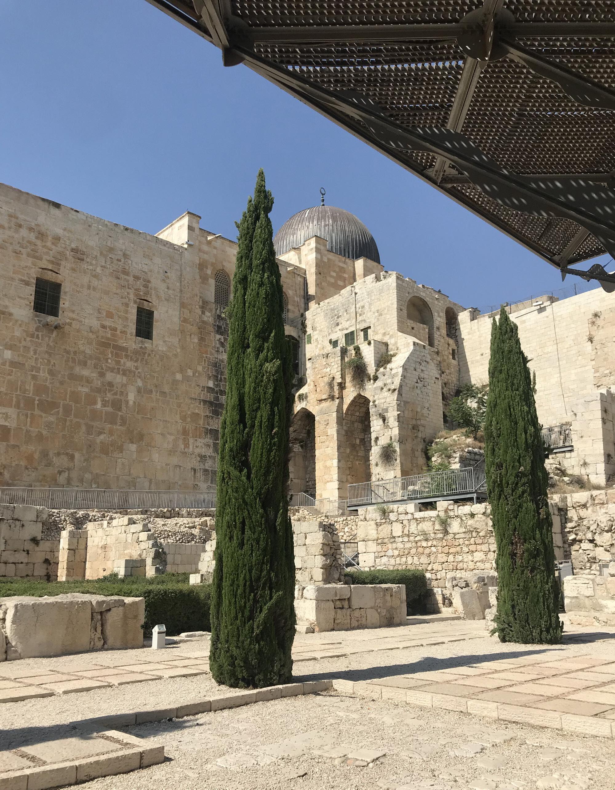
Fig. 1. Olive Trees outside of Al-Aqsa Mosque, Jerusalem, Samantha Miller.
Fig. 2. Two Cupressus sempervirens in Jerusalem, Samantha Miller.
Fig. 3. Hebron, the home of Abraham, Issac and Jacob, 1899, Israeli Archives. Public Domain.
Fig. 4. Map of current legal/de facto borders in Israel/Palestine using Google Earth imagery as a base, Samantha Miller.
Fig. 5. Overlooking Masada, Samantha Miller.
Fig. 6. Concept diagram, Samantha Miller.
Fig. 7. Map of wall and checkpoints, Samantha Miller.
Fig. 8. A section of the West Bank separation barrier in Bethlehem, April 2009, Daniel Case, Public Domain.
Fig. 9. Israeli West Bank barrier near Jerusalem, September 2010, Antoine Taveneaux, Public Domain.
Fig. 10. Diagram of the Green Line and the Wall, Samantha Miller.
Map of Separation Barrier, surrounding political and ecological contexts, and land use index chart, Samantha Miller.
Fig. 11. Map of Separation Barrier and surrounding political and ecological contexts, Samantha Miller.
Fig. 12. JNF blue boxes, Samantha Miller.
Fig. 13. View from Yad Vashem Holocaust Museum, Samantha Miller.
Fig. 14. Drawing of sample 101 from land use index showing pine habitat and relationships, Samantha Miller.
Fig. 15. Olive trees near Nablus, 2022, Izzeddin Hawamda.
Fig. 16. Drawing of sample 20 from land use index showing olive habitat and relationships, Samantha Miller.
Fig. 17. Planting scheme axo sketches, Samantha Miller.
Fig. 18. Planting scheme axo sketches, Samantha Miller.
Fig. 19. Location of precedents, Samantha Miller.
Fig. 20. Freedom Park in Salvokop, Pretoria, September 2013, Leo za1. Public Domain.
Fig. 21. Isivivani - Freedom Park. Pretoria, South Africa, June 2011, Shosholoza. Public Domain.
Fig. 22. Freedom Park, Salvokop, Pretoria , September 2013, Leo za1. Public Domain.
Fig. 23. The Walled Off Hotel by Banksy in Bethlehem, West Bank, March 2017, Addy Cameron-Huff. Public Domain.
Fig. 24. The segregation wall in front of the walled off hotel, May 2017, no author. Public Domain.
Fig. 25. Banksy mural of Palestinian and Israeli solider having a pillow fight painted in one of the hotel rooms (by Walled Off Hotel, n.d.)
Fig. 26. Stepped amphitheatre using marble retrieved from nearby doorsteps, 2007, Karl Linn.
Fig. 27. Community members actively engaging in collecting and preparing salvaged materials, post construction, and making music while construction occurred, 2007, Karl Linn.
Fig. 28. Completed project with stepped amphitheatre and play area, 2013, Anna Goodman.
Fig. 29. Map of three intervention sites atop locations of forests and olive groves, Samantha Miller.
Fig. 30. Map of location of olive groves and pine forests, Samantha Miller.
Fig. 31. Khirbet Zakariyya before the Nakba, Palestine Remembered.
Fig. 32. Attack on Khirbet Zakariyya, Israeli Archives. Public Domain.
Fig. 33. Hill where Khirbet Zakariyya was, Hasan Hawari.
Fig. 34. Officer from 1948 drinking from well, Israeli Archives. Public Domain.
Fig. 35. Stones left behind, 2007, Noga Kadman.
Fig. 36. Map of destroyed villages and forests, with story 01, Samantha Miller.
Fig. 37. Context and access map for Story 01, using Google Earth Imagery as a base, Samantha Miller.
Fig. 38. Full site plan showing clearly marked gardens in the footprints of destroyed homes, Samantha Miller.
Fig. 39. Full site section, Samantha Miller.
Fig. 40. Zoomed-in plan of one of the footprint gardens, Samantha Miller.
Fig. 41. A place to witness the mourning of others, Samantha Miller.
Fig. 42. Moving rubble to make gardens becomes an act of acknowledging and making space for mourning, Samantha Miller.
Fig. 43. Perspective of one of the marked home gardens in Ben Shemen Forest, Samantha Miller.
Fig. 44. Files on no man’s land, 1948, Israeli Archives. Public Domain.
Fig. 45. Files on Oasis of Peace, 1993, Israeli Archives. Public Domain.
Fig. 46. Greek aircraft helping in firefighting efforts, 2016, Avi Ben Zaken. Public Domain.
Fig. 47. Firefighting plane near Nataf, 2016, Ronen Zvulun.
Fig. 48. Palestinian firefighters aid in firefighting, 2016, Lior Mizrahi/Getty Images. Public Domain.
Fig. 49. Map of national burning index and forests, with story 02, Samantha Miller.
Fig. 50. Context and access map for Story 02, using Google Earth Imagery as a base, Samantha Miller.
Fig. 51. Full site plan of story 02, showing program spaces for community building in No man’s land, Samantha Miller.
Fig. 52. Gathering space with dense conifers on edge for privacy, Samantha Miller.
Fig. 53. Prayer area facing Mecca and the Western Wall, Samantha Miller.
Fig. 54. Community garden for growing food together, Samantha Miller.
Fig. 55. Cutting burnt trees to build infrastructure or clearing them for space, Samantha Miller.
Fig. 56. Space to eat and gather facilitates cross cultural celebration and dialogue, Samantha Miller.
Fig. 57. Beit Jala residents protest wall, 2016, Ryan Beiler/Activestills.
Fig. 58. Uprooting olives, 2015, Sarit Michaeli.
Fig. 59. Map of violence rings and olive groves, with story 03, Samantha Miller.
Fig. 60. Context and access map for Story 03, using Google Earth Imagery as a base, Samantha Miller.
Fig. 61. List of protected species under Israeli Law that are suitable for the site, Samantha Miller.
Fig. 62. Full site plan of story 03 showing planted terraces through the plans for the wall, Samantha Miller.
Fig. 63. Section through site showing existing olive groves and proposed terraces, Samantha Miller.
Fig. 64. Planting plan of protected species, Samantha Miller.
Fig. 65. Section through terraces, Samantha Miller.
Fig. 66. Moving plants as a guerrilla planting effort to protect Palestinian land sovereignty, Samantha Miller.
Fig. 67. Perspective of story 03, to maintain a sense of rootedness for occupied Palestinians in Beit Jala, Samantha Miller.
Fig. 68. Connection to olive tree you cannot reach, Samantha Miller.


Acknowledgments
I was born and raised in Treaty 1 territory in what is now known as Winnipeg, Manitoba. These lands are the traditional and ancestral territories of the Anishinaabeg, Cree, Oji-Cree, Dakota and Dene Peoples and the homeland of the Métis Nation. I recognize that the lands in which I grew up were shaped by these Nations.
Now, I live in so-called Vancouver, on the traditional and unsurrendered territories of the xʷməθkʷəyəm (Musqueam), Sḵwxwú7mesh (Squamish), and Selílwitulh (Tsleil-Waututh) Nations. I am studying at the University of British Columbia, which is a colonial institution sitting on the traditional and unsurrendered territory of the xʷməθkʷəyəm (Musqueam) Nation. These Nations have experienced and continue to experience active colonization, genocide, and dispossession. I recognize that I have personally benefitted from this dispossession. I am committed not to simply acknowledging the Nations of these territories but to understanding, that acknowledgment is an active dedication to decolonization.
Thank you to my friends and family for supporting me in any way possible throughout my academic journey. I appreciate your open-mindedness and sensitivity to this difficult topic. Nick, thank you for being my rock and for teaching me something new every day. Thank you to my friends at رسج/Bridge/ רׁשג, to whom I owe the inspiration for this project. Izzeddin, Sam, Karen, Micaela, Zhila, Leah, Muhammed, Berrigan, Ademola, Frances, Allan, Joanna, Loraine, and Tali – your honesty, empathy, and compassion lifted me and changed my world. A special thanks to my committee members: Izzeddin (Izzy) Hawamda for your encouragement, support, and ability to make beautiful words out of an ugly conflict. It is an honour to work with you. JB and Nada, your encouragement and patience as we worked through best practices and approaches to narrative and design thinking were paramount in the success of this project. To my advisor, Fionn, thank you for pushing me to be rigorous and attentive, but allowing me to express myself in this project. Your knowledge, passion for landscape architecture, and dedication to this project inspired me to test the limits of this work.
For Saba
This project is dedicated to my late Saba, Yoram. A beloved family man, carpenter/ builder/fixer of all things, and soldier. With every word I write, I think of you.