

TABLE OF CONTENTS
p. 8
p. 9
p. 10 p. 11
p. 12
p. 13
PENN STATE STORMWATER LIVING LAB: A Multi-Disciplinary Initiative to Shape Penn State Into a National Green Stormwater Infrastructure Leader
Hong Wu
HOW DESIGN OF GARDEN-BASED LEARNING IMPACTS WELL-BEING IN ELEMENTARY SCHOOLS
Julia Traub
FINDING COMMON SPACE: Reconciling One Health Socio-Environmental Factors in PA
Leann Andrews, Justin Brown, Sona Jasani, Stephen Mainzer
THE URBAN-RURAL BATTLEGROUND: Statewide Socio-Ecological System
Drivers of Voting in PA
Stephen Mainzer, Travis Flohr
BURNOUT: The Impacts of Extraction
Laia Celma, Pep Aviles, Miranda Esposito
URBAN TREE PATTERNS IMPACTS ON URBAN MICROCLIMATE: A Geospatial Simulation Data Pipeline for Multi-Neighborhood Scale Landscape Metric Analyses
Travis Flohr, Mehdi Heris, Elizabeth Derycke
p. 14
p. 15
p. 16
p. 17
p. 18
THE LOWER TRAIL IN WILLIAMSBURG: Analysis and Framework Plan
Alec Spangler
RESILIENT AND ENERGY EFFICIENT ENVELOPES FOR PASSIVE HOUSE STANDARD BUILDINGS
Cayla Erisman, Lisa Iulo, Karim Abdelwahab, Corey Griffin, Ali Memari
HOUSEING EQUITY IN STATE COLLEGE
Lisa Iulo
OBJECTIVE DESIGN STANDARDS: San Francisco Planning Department
Epiphany Loux
A PARAMETRIC APPROACH FOR INVESTIGATING CANOPY HEAT ISLAND EFFECTS ON BUILDING ENERGY PERFORMANCE: A Case Study in Seven U.S. Cities
Farzad Hashemi, Ute Poerschke, Lisa Iulo
p. 19
p. 20
URBAN MICROCLIMATE, OUTDOOR THERMAL COMFORT, AND SOCIOECONOMIC MAPPING: A Case Study of Two U.S. High-Density Cities
Farzad Hashemi, Ute Poerschke, Lisa Iulo, Guangqing Chi
PARAMETRIC INVESTIGATION OF URBAN HEAT ISLAND MITIGATION STRATEGIES: A Case Study of Pine Hall Traditional Town Development (TTD), Ferguson Township, Centre County, Pennsylvania
Farzad Hashemi, Ute Poerschke, Lisa Iulo
TABLE OF CONTENTS
EXAMINING THE RELATIONSHIP BETWEEN DESIGN FEATURES AND THE ACTUAL PERFORMANCE OF BUILDINGS DESIGNED AND CONSTRUCTED UNDER ENERGY EFFICENCY STANDARDS
Jie Lie, Lisa Iulo, Ute Poerschke
ENERGY +: Creating a Retro Fit Program
Kristine Luther
VISUAL AND CULTURAL RESOURCE CONSERVATION AT THE LANDSCAPE
SCALE: A Dissertation in Architecture and Human Dimensions of Natural Resources and the Environment
Lacey Goldberg
BIORETENTION LANDSCAPE DESIGN FOR POLLUTANT REMOVAL
Leslie Hendricks, Hong Wu
EVALUATING COMMUNITY ENGAGEMENT MECHANISMS FOR GREEN STORMWATER INFRASTRUCTURE DEVELOPMENT
Mahsa Adib, Hong Wu, Travis Flohr, Tim Kelsey
A STUDY OF DAYLIGHT MODELING APPROACHES APPLIED IN LEED
Maryam Esmailian
A METHOD FOR GREEN INFRASTRUCTURE PLACEMENT UNDER DEEP
UNCERTAINTY: An Introduction to the Application of Many-Objective Robust Decision Making (MORDM) in GI Planning
Maryam Esmailian
PSIRC: Penn State Initiative for Resilient Communities
Lisa Iulo
ALGAE BIO-REACTOR BUILDING ENVELOPE: Energy Saving and CO2
Sequestration information Display Shading System
Jingshi Zhang, Rahman Azari, Ute Poerschke
MOVEABLE SHADING SYSTEMS: Developting an Algorithm to Simulate the Energy Performance of Moveable Shading Systems
Meysam Akbari Paydar, Rahman Azari, Ute Poerschke
MODELS TO ASSESS AND REVERSE THE ENVIRONMENTAL IMPACT OF BUILDINGS: RE2 Lab Research and Teaching
Rahman Azari
MITIGATING URBAN HEAT ISLAND BY VEGETATED INFRASTRUCTURE: A Case Study of Dhaka, Bangladesh
Tasneem Tariq, Ute Poerschke, Lisa Iulo
COLLABORATIVE PRACTICES: A Literature Review of Evidence-Based Studies
Cathy Braasch, Patricia Klucker, Danica Williams, Sydney Yakowenko
CELEBRATING THE WORKS OF THE GLOBAL MAJORITY: Precedents In Design
Joshua Achampong, Alisa Asare, Claudia Bowes, Cathy Braasch, Luke Scanlon, Sydney Yakowenko
TABLE OF CONTENTS
USING WASTE CARDBOARD TO BUILD & SUSTAIN THE RESILIENT CITY:
An Exhibition for the 2021 Seoul Biennale of Architecture and Urbanism (2021 SBAU)
Julio Diarte, Marcus Shaffer, Elena Vazquez, Yun Kyung Gal
KONRAD WACHSMANN’S SHIFT FROM PRODUCT TO PROCESS:
Prefiguring Automated Industrialized Building in Architecture Through Developments in “Universal” Building Machines
Elizabeth Andrzejewski
KONRAD WACHSMANN’S SHIFT FROM PRODUCT TO PROCESS: Location Orientation Manipulator
Elizabeth Andrzejewski
PROBING THE UNIVERSAL WITH MACHINES: Exploring the Potential of a CNC Plasma Cutter to Manufacture Parts-Based Industrial Housing
Marcus Shaffer, Elizabeth Andrzejewski
DEVELOPING DIGI-MECHANICAL FORMWORK FOR PLASTIC
CONSTRUCTION MATERIALS: Testing Forming Capabilities and Motion Control Using 3D-Printed Working Models
Marcus Shaffer
CREATIVE COGNITION: Learning Science and Pedagogy for Creativity
Patricia Kucker
THE IMPACT OF STUDIO CULTURE: On Students in Schools of Art and Design
Wanda B. Knight, Partricia Kucker, Cathy Braasch, Marc Miller, Joel Priddy, Angela Rothrock
RE-EXAMINING SEWN EARTHBAG GEOMETRIES: And Their Impact on Structure and Construction Workflow
Tiffanie Leung, Marcus Shaffer, DK Osseo-Asare
WHITE AFTER DARK: The Story of a Sundown Town
Blake Thresher
WELCOME KIT FOR COPORT: A Design Solution for Integrating the Artifacts That Communicate, Promote, and Reinforce the Common Shared Beliefs and Behaviors that Bind the Individuals to an Organization in a Shared Office
Huiwon Lim, Yongyeon Cho, Hye Jeong Park
A BLOOMING STORY: A Data Visualization Designed for a Digital Screen at the Penn State Library
Shatakshi Mehra
PUBLIC PERCEPTION OF ECOSYSTEM BENEFITS OF GREEN
STORMWATER INFRASTRUCTURE: A Case Study in Chinese Sponge Cities
Rui Wang, Hong Wu
TABLE OF CONTENTS
50
51 p. 52 p. 53
p. 54
p. 55
p. 56
p. 57
p. 58
p. 59
BISTABLE KINETIC SHADES: Actuation Studies with Shape Memory Alloys and Prototype Development
Elena Vazquez, Jose Duarte
THE PANAM NAGAR GRAMMAR: A Shape Grammar to Analyze the Colonial Houses and Urban Settlement at Panam Nagar, Bangladseh
Enam Rabbi Adnan, Heather Ligler, Jose Duarte, Denise Costanzo Madhuri Desai
VIRTUAL REALITY IN DESIGN EDUCATION: Evaluating the Impact of Immersive Technology on Spatial Ability Development in Beginning Architecture Students
Eric Mainzer
A CRAFT GAME-BASED RESPONSIVE ARCHITECTURE
Farzaneh Oghazian, Felecia Davis
CALIBRATING A FORM-FINDING ALGORITHM: For Simulation of Knitted Tension Structures
Farzaneh Oghazian, Nathan Brown, Felecia Davis
UNDERSTANDING THE IMPACT OF URBAN FEATURES ON COVID-19 SPREADING
Fernando T. Lima, Nathan Brown, Jose Duarte
URBAN DESIGN OPTIMIZATION: A Generative Approach Towards Urban Fabrics with Improved Walkability
Fernando T. Lima, Nathan Brown, Jose Duarte
WORLD STUDIO: A Pedagogical Experience Using Shape Grammars and Parametric Approaches to Design in the Context of Informal Settlements
Fernando T. Lima, Naveen Muthumanickam, Marc Miller, Jose Duarte
MYCOCREATE: Design and Fabrication of Spatial Structures with MyceliumBased Composites
Ali Ghazvinian, Benay Gursoy
SEE-SENSE-RESPOND: Exploring Modalities of Augmented Robotic Fabrication for Automation and Beyond
Ozguc Bertug Capunaman, Benay Gursoy
FRAME HOUSE: An Open-Source Design and Build-It-Together Sustainable Housing System
Puja Bhagat, Celina Deng, Baney Gursoy
DESIGN FOR PRINTABILITY AND STRUCTURAL INTEGRITY OF 3D-PRINTED CONCRETE STRUCTURES
Goncalo Duarte, Jose Duarte, Ali Memari, Nathan Brown, Juan Pablo Gevaudan, Shadi Nazarian
GENERATIVE REDESIGN: Minimizing Carbon Costs
Holly Zimmerman, Sierra Hogan, Heather Ligler, Rebecca Napolitano p. 47 p. 48 p. 49
TABLE OF CONTENTS
p. 60
p. 61
p. 62
LOW-COST AND LOW-IMPACT CARDBOARD FORMWORK: Waste
Cardboard as an Alternative for Single-Use Conrete Formwork
Julio Diarte, Marcus Shaffer, Elena Vazquez
BURN OUT: The Impacts of Extraction
Laia Celma, Pep Aviles, Miranda Esposito
COMBINING GEOGRAPHIC INFORMATION SYSTEMS AND SHAPE GRAMMARS TO UPGRADE PUBLIC OPEN SPACES IN INFORMAL SETTLEMENTS: Toward a Systematic Green Framework
Lara Garcia, Jose Duarte
p. 63
p. 64
p. 65
p. 66
p. 67
UNIVERSAL DESIGN SPACES: Early Design Approach + Exploration Methods
Laura Hinkle, Leland Curtis, Nathan Brown
INTEGRATION OF CLIMATE-SPEDIFIC ENERGY-EFFICIENT BUILDING DESIGN INTERVENTIONS IN THE PAKISTANI RESIDENTIAL SECTOR
Maryam Aman, Ute Poerschke, Jose Duarte
MARKET SQ GRAMMAR: Reconstructing the Facades of Warsaw’s Old Town
Marzena Nowobilski, Heather Ligler
MATERIAL CHARACTERIZATION FRO 3D PRINTING CONCRETE:
Experimental Compensation for Deformation in the Printing of Small Parts
Negar Ashrafi, Jose Duarte, Shadi Nazarian, Nicholas A Meisel
AUGMENTED REALITY + AI & THEIR POTENTIAL IMPACT ON MASS
SOCIAL BEHAVIOR: Exploring the Impact of the Fourth Wave of Technology to Reverse or Mend the Adverse Effects of the Third Wave Using the Arts
Rodney Allen Trice
p. 68
p. 69
p. 70
GENERATIVE REDESIGN: Adaptive Grammars
Sierra Hogan, Daniele Paulino, Heather Ligler, Rebecca Napolitano
THE FLOWER ANTENNA: Knitted Wide Band Receiving Antenna
Felecia Davis, Farzaneh Oghazian, Berfin Evrim, Niousha Keyvani, Thomas Dimick, Lee Washesky, Erin Lewis, Leah Resnick, David Reibe
COMMUNICATION AND EFFICACY BETWEEN DIVERSE DESIGN TEAMS OF ARCHITECTS AND ENGINEERS
Stephanie Bunt, Nathan Brown
p. 71
p. 72
USING MACHINE LEARNING TO INFORM THE SPATIAL DESIGN OF ENERGY SELF-SUFFICIENT COMMUNITIES
Bina Rahimian, Jose Duarte, Lisa Iulo
A GRAMMAR-BASED METHODOLOGY TO SUPPORT THE ADAPTIVE REUSE OF HISTORIC BUILDINGS: The Case Study of the Sobrado Building Type
D.M.S. Paulino, R.K. Napolitano, H. LIgler, K. Bak, E. Hill
TABLE OF CONTENTS
p. 73
DELHI’S LEISURE SPACES: Patterns of Spatial Use in a Mixed-Income
Informal Settlement
Sana Ahrar, Alexandra Staub
p. 75 p. 74
SPACES OF IDENTITY: How the Marzloh Mosque Shapes Turkish-German Women’s Belonging and Sense of Community
Iram Oz, Alexandra Staub
MEDIA CONSTRUCTION OF THE CHESAPEAKE BAY WATERSHED: A Tale of Three Cities
Zheng Cui, J.J. De La Cruz, James Dillard, Andy High, Stephen Mainzer, Juliet Pinto, Andy Cole

Funded by Penn State’s University Strategic Initiative Seed Grant, the Stormwater Living Lab utilizes Penn State’s multi-campus network to create a living laboratory for Green Stormwater Infrastructure (GSI) research, education, and innovation. We endeavor to transform the University into a national GSI leader and build community capacity in the long term to implement cost-effective solutions.
CORE FACULTY
Our core faculty currently includes scholars and Extension educators from multiple disciplines, including Landscape Architecture, Civil and Environmental Engineering, Biological Engineering, Economics, and Plant Sciences.


COMMUNITY PROJECTS
• Lancaster, PA. Environmental monitoring at Brandon Park bioretention.
• Mount Joy, PA. Bioswale redesign project for the Reverse at Union School property.
• Philadephia Water Department. PA. Bioretention redesign project at Botanic Ave. & 49th -51st Streets
SELECTED PUBLICATIONS/PRESENTATIONS
• [P] Wu, H., & Myerov, S. (2021/7/21). “COVID-19 Impacts on Pennsylvania MS4 Communities,” Penn State Extension July Water Cooler Talk, Virtual, Invited.
• [J] Adib, M., & Wu, H. (2020). Fostering Community-engaged Green Stormwater Infrastructure (GSI) through the Use of Participatory Geographic Information System (PGIS). Journal of Digital Landscape Architecture(5), 549-557.
• [P] Tebyanian, N., Wu, H., & Iulo, L. D. (2021). “Green Infrastructure Placement Under Deep Uncertainty,” The 17th International Conference on Computational Urban Planning and Urban Management, peer-reviewed. International.
• [B] McPhillips, L., Wu, H., Lerer, S., Rojas, C., Rosenzweig, B., Sauer, J., & Winfrey, B. Nature-Based Solutions as Critical Urban Infrastructure for Water Resilience. In McPhearson T., Frantzeskaki N., & Kabisch N. (Eds.), A Modern Guide to Naturebased Solutions for Cities. Northampton, MA, USA: Edgar Elgar Publishing. (Forthcoming)


PENN STATE STORMWATER LIVING LAB
A MULTI-DISCIPLINARY INITIATIVE TO SHAPE PENN STATE INTO A NATIONAL GREEN STORMWATER INFRASTRUCTURE LEADER
AUTHOR: HONG WU


https://sites.psu.edu/stormwaterlivinglab
SELECTED FUNDED PROJECTS
• Wu, H., McPhillips, L., Mina, O., Brent, D., Clark, S. E., Cole, C. A., Gutberlet, A. D., Richard, T. L., Hoskins, M., Fetter, J., Hoag, D. A.S., “Greening Our Stormwater: Using Campuses as Living Labs for Green Stormwater Infrastructure,” Penn State University Strategic Initiatives. $249,883 (July 2019 - June 2023).
• Wu, H., Mina, O., McPhillips, L., Brent, D., Cole, C. A., “Improving Green Stormwater Infrastructure Performance and Cost-effectiveness on Penn State’s University Park Campus,” Penn State Office of Physical Plant. $33,665 (Feb. 2019Feb. 2020).
• Wu, H., Mina, O., Grant, “Multi-variate Evaluation of Green Stormwater Infrastructure on Penn State University Campus,” E+D: Ecology Plus Design, Penn State. $14,000 (July 2018 - June 2020).
• Wu, H., Flohr, T. L., Yencha, A., Adib, M., “A Web App for Enhancing Knowledge Transfer and Science Communication in Community Engagement during Pandemic Time and Beyond,” Hamer Center for Community Design, Penn State. $10,000 (March 2021 – June 2022).
• McPhillips, L., Clark S. E., Hoffman, M., Wu, H., & Gotsch. “Impacts of salt loading on nutrient and metal processing in stormwater bioretention,” Chesapeake Bay Trust. $196,183 (July 2021- August 2023).
• Clark, S. E., Mysliwiec, T. H., Felker, J. M., Blaszczak-Boxe, C., McPhillips, L., Wu, H., Driscoll, W. W., Moazeni, F., Spear, J. M., “Water quality assessment of an urban watershed in Lancaster, PA: Implications for environmental justice,” Penn State Institutes of Energy and the Environment. $30,000 ( June 2021 – June 2022).
• Hoffman, M., McPhillips, L., Wu, H., Skvarla, M., “Green Stormwater Infrastructure: Design, Maintenance and Location Impacts on Biodiversity,” Mainstreaming Biodiversity in a Decade of Action Seed Grant, Penn State. $9,910 (June 2021 - June 2022).
SELECTED STUDENT WORK
PH.D. DISSERTATIONS
• Tebyanian, N. (LARCH). “Green Infrastructure Placement Under Deep Uncertainty: A case of flooding towards Multiple Ecosystem Services.”
• Wang, R. (LARCH). “Getting Green Awareness: Exploring the Public Perception and Socio-Cultural Values of Green Stormwater Infrastructure in Chinese Sponge Cities.”
• Adhikari, B. (CE & EE). “Metals Accumulation in Urban Green Stormwater Infrastructure.”
• Adib, M. (ARCH). “GSI Community Engagement.“
SELECTED MASTERS’ THESIS & CAPSTONES
• Fischer, C. (Penn State Harrisburg, EE), “Impacts of Road Salt-Laden Snowmelt and Rainfall on Soil Moisture and Soil Electrical Conductivity in a Bioretention System in Lancaster, PA.”
• Hendricks, L. (LARCH), “Bioretention Planting Design for Salt Uptake and Pollutant Removal.”
UNDERGRAD STUDENT RESEARCH
• Roy, S. (Middlebury College). “Carbon Sequestration and Greenhouse Gas Emissions in Urban Green Infrastructure: A Case Study of Penn State’s University Park.” Penn State Drawdown REU.
• Weikel, M. (New York University). “Framework for Assessing Climate Change Implications of Green Stormwater Infrastructure.” Penn State Drawdown REU.


Greenhouse experiment on salt impacts on plants by plant sciences graduate Tim Gilpatrick.
Stormwater flow monitoring at Penn State’s IM Building rain garden.
Greenhouse experiment on plant nutrient removal capabilities.
M.L.A. grad Leslie Hendricks working with the Mt. Joy community on bioswale redesign.
Rain garden flow testing on the Penn State campus.
Hong Wu (Director) Daniel Brent
Lauren McPhillips Meghan Hoskins
Shirley Clark (Harrisburg)
Odette Mina
Margaret Hoffman Tyler A. Groh
Andy Yencha Michael J. Skvarla
Jennifer R. Fetter
RESEARCH OVERVIEW
BACKGROUND
The impact of green space on the well-being of individuals has been shown to be beneficial.
Current metrics on the effect of green spaces on school campuses are not comprehensive and, therfore, are ill-defined and narrow.
The effectiveness of the implementation of these green spaces needs a coherent general metric.
The proposed intention of this study is to develop a holistic framework including impactful factors of gardens on elementary-aged students through a structured meta-analysis of existing models and theories.

Ages 6-12 are a crucial time of individual development and learning. Children of these ages also posses curious, nonbiased values.

Many studies of time-logging indicate that the average American student spends about 15% of their time in school (25% of waking hours).

HOW DESIGN OF GARDEN-BASED LEARNING IMPACTS WELL-BEING IN ELEMENTARY SCHOOLS
AN ANALYSIS OF POST-2010s RESEARCH
AUTHORS: JULIA TRAUB
RESEARCH
QUESTION(S) AND METHODS
1. According to existing literature, what are the current models and/or theories that describe and/or evaluate the dimensions of well-being in schoolyard gardens?
2. How do current models and/or theories combine, overlay, or conflict in relationship to creating a holistic model of natural schoolyard well-being?
MAIN METHODOLOGY: Meta-analysis and case studies

FINDINGS/CONTRIBUTIONS
The goal of this study is to provide a theoretical framework as a tool for designers and educational personnel to optimally design effective greenspace in schoolyards. This specific model intends to consider the six different dimensions of wellness in the creation of an evaluative framework to achieve a more comprehensive view of schoolyard greenspace effectiveness.
From the table above, it can be understood that open lawn space encourages promotion of social well-being. Therefore, the framework will work in the sense that schoolyards with weak social well-being can easily identify physical design characteristics that could improve this dimension. Generally, the impact of different design characteristics in the literature connect with one of the six dimensions of well-being: emotional, occupational, physical, social, intellectual, and spiritual.
Green space has been shown to improve problems with attention deficeit, cognitive disorders, literacy scores, and more.
IMAGE CREDIT: WILLIAMS & DIXON
ABSTRACT:
One Health promotes the idea that the health and well-being of all species are inextricably linked to each other and the environment in an integrated health triad of human-animalenvironment. With a large economy based on agriculture; manufacturing; forestry; hunting; outdoor recreation and resource extraction; stressed ecosystems; and rising diseases that connect humans, animals, and the environment, Pennsylvania is an ideal location to study One Health.
What are the socio-environmental determinants of perinatal health in humans, and animals, in Pennsylvania?


Technical Advisory Committee Student Representatives
Syeda Saman Naz, Ph.D. student in Health and Human Development
Lily Zeitler, Ph.D. candidate in Geography
Tiza Ignatius Mfuni, Ph.D. candidate in Geography
Kelsee Baranowski, Ph.D. candidate in Biology
2021-22 One Health Scholars
Somdeep Nandy, Master of Landscape Architecture / UP
Rachel Weninger, Bachelor of Veterinary + Biomedical Science / UP
Tong Wen, Master of Public Health / Hershey
Caroline Eisele, 2nd-year Medical Student / Hershey
FINDING COMMON SPACE:
RECONCILING ONE HEALTH SOCIOENVIRONMENTAL FACTORS IN PA
LEANN ANDREWS, JUSTIN BROWN, SONA JASANI, & STEPHEN MAINZER
Disparities in wealth and education, political and rural-urban divides, and spatially marginalized racial and ethnic groups create an opportunity for this inquiry to take an environmental justice and equity lens. Divided by colleges and campuses, our expertise at Penn State to understand and address these pressing issues is siloed. In response, we propose to pilot a unified Pennsylvania One Health spatial database as a platform for interdisciplinary connections between University Park and Hershey researchers, to identify gaps in traditionally disciplinary data and demonstrate our potential for integrated collaboration.
While there are substantial data focused on human health, animal health, socio-political, environmental and demographic characteristics of the Commonwealth, there are equally substantial barriers to integrated analysis and action. Starting with an initial focus on the socio-environmental and ecological factors of perinatal health in humans and animals, we will unify diverse data through a common spatial lens while engendering conversations to break through diverse disciplinary jargon and research approaches and create a platform for interdisciplinary integration of faculty and support a cohort of One Health Scholars within Penn State.
FUNDING: 2020-21 Institutes of Energy & the Environment Seed Grant Program, Health & the Environment
PROCESS AS OUTCOME #1: An Interdisciplinary Cross-Campus Collaborative Team
PRODUCT AS OUTCOME #2: One Health Spatial Database

https://www.onehealthcommission.org/en/why_one_health/
While there are substantial data focused on human health, animal health, socio-political, environmental, and demographic characteristics of the Commonwealth, there are equally substantial barriers to integrated analysis and action. Starting with an initial focus on the socio-environmental and ecological factors of perinatal health in humans and animals, we will unify diverse data through a common spatial lens while engendering conversations to break through diverse disciplinary jargon and research approaches and create a platform for interdisciplinary integration of faculty and support a cohort of One Health Scholars within Penn State.

Percent Low Birth Weight Births, 2015-2019

Percent population that is people of color, 2015-2019

Associations between low birth weight, rates, and fracking, 2018

Percent Preterm Births, 20152019

Estimated median age of all people, 2015-2019

Presidential Election Results, 2020

Percent of Births to Mothers Who Had a Prenatal Care Visit in the 1st Trimester, 2015-2019

Estimated percent of all families that live in poverty, 2015-2019
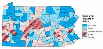
River Otter Population Health, 2015
https://www.health.pa.gov/topics/HealthStatistics/VitalStatistics/CountyHealthProfiles/Documents/current/index.aspx (top row); https://pennstate.policymap.com/newmaps#/ (middle row); https://advances.sciencemag.org/content/3/12/e1603021; https://www.mrlc.gov/viewer/, https://www.nytimes.com/interactive/2021/upshot/2020-election-map.html (bottom row)
RESEARCH OVERVIEW
Environmental design and planning are becoming increasingly polarized along partisan lines in the United States (Zawadzki 2020, Howe et. al. 2015, Hahnel 2019). Landscape architects are increasingly engaging in systemic large-scale climate change issues beyond the single client development model — e.g., renewable energy and hazard planning — that cross multiple political divides. Yet, initiatives are slow to materialize because embattled fractures prevent the passage of legislation, such as the Green New Deal, that would realign the country with global efforts to adapt to climate change. Political sentiment typically follows urbanrural spatial patterns (Wallace et. al. 2009, McKee 2008), suggesting that the biophysical environment has an influential role in socio-political values and behavior. Efforts to explain political activity have often relied on estimating individual behaviors from aggregate data or ecological inference (Amos, McDonald, & Watkins 2017, Hirsch and Nall 2016). Yet, to our knowledge, these efforts have been limited to social variables and have espoused the role of the biophysical environment.
Pennsylvania, a key battleground state in the 2020 Presidential Election, appears to follow these alignments as the traditionally rural counties of Appalachia are generally more conservative despite a higher reliance on natural resource industries (Mainzer, Cole, & Flohr 2019). Our exploratory geospatial analysis of Pennsylvania attempts to describe voting patterns through the ecological inference of biophysical and social factors. We aggregate a representative range of biophysical conditions — including land use, forest quality, farmland quality, conservation lands, the Rural-Urban Continuum Codes index, and traditional demographic characteristics — at the voting precinct level for the entire state (n = 9,275) and explore correlations with the 2018 Midterm Election results across state and local elections.


https://fivethirtyeight.com/features/donald-trump-paris-climate-agreement/ https://fivethirtyeight.com/features/how-hatred-negative-partisanship-came-to-dominate-american-politics/

THE URBAN-RURAL BATTLEGROUND:
STATEWIDE SOCIO-ECOLOGICAL SYSTEM DRIVERS OF VOTING IN PA
STEPHEN MAINZER & TRAVIS FLOHR
FINDINGS


RURAL-URBAN
FOREST (HIGH QUALITY)
(PRIME)
WETLANDS
ENVIRONMENTAL FACTORS (OVERLAY)
BURN OUT
BACKGROUND
This project explores the vertical nature of the environment through the intimate relationship that exists between the economies of extraction and climate change. Human action ignited the Buck Mountain anthracite vein in Centralia, Pennsylvania in 1962. As a result, the former abandoned mines will continue smoldering in the following decades, if not centuries, ahead. Far from unique catastrophic events, coal mine fires are a constant in human history. However, the number and impact of these fires increased significantly during industrialization, releasing methane, carbon monoxide, carbon dioxide, sulfur, and particles to the atmosphere on a regular basis. Together, they contribute to the greenhouse effect responsible for climate change and global pollution affecting the planet. Given the difficulties to file liabilities and to measure the effects of these fires, they usually fall under the category of unmitigated risk

In addition to above-ground effects that resulted in the abandonment of the nearby urban settlements, coal mine fires dramatically change the microbiota of the soil of the region, activating dormant microbes due to changes in underground temperatures. This proposal aims at visualizing the complex nature of human and non-human environmental interactions departing from the case of Centralia.
BURN OUT
THE IMPACTS OF EXTRACTION
AUTHORS:
LAIA CELMA, PEP AVILES, & MIRANDA ESPOSITO
COLLABORATORS: Sekhar Bhattacharyya, Benjamin Bishop, Audrey Buck, Ken Davis, David Dekok, Nicoletta Filippidou, Daniel Lopatka, Natasha Miles, Scott Richardson, Ashley Shade, Can Sucuoğlu, Emily Weinert, Cynthia White, Li Xin
OBJECTIVES
This ongoing research focuses on fabricating a prototype that stages the aircomposition data coming from the exiting boreholes in Centralia. The prototype consists of a gas-reading chamber and a first cylindrical section made with the microbes from the area that, together with gas sensors, will feed information to an internal computer system that transforms the data into electricity and sound before releasing the gases into the atmosphere. The goal is to demonstrate that the underground planning of former coal mining still affects the air quality on the planet at different scales and temporalities.


LAIA CELMA, MIRANDA ESPOSITO, MARC MILLER, PEP AVILES
Oslo Architecture Triennale, 2019
Workers inside the North Ashland breaker at Dark Corner, 1890.
Carbon monoxide detectors in Centralia circa 1970s. Photograph © David Dekok.
Centralia, late 1970s.
Centralia, 1970s, Photograph © David Dekok
Centralia in the 1970s. Potograph © Renée Jacobs
Demolition of houses in the 1980s. Photograph © David Dekok.
Image of one of the existing boreholes in Centralia.
Sectional Model. Photography © José Hevia.
Drawing of existinnng and former constructions in Centralia.
United States Geological Survey, 1971 Geologic map of the region. Centralia located in the mid-left portion of the map.
Existing Signs in today’s Centralia
INTRODUCTION
This poster presents a novel spatial data pipeline supporting an ongoing collaborative urban heat island (UHI) research study. This study aims to evaluate the existing tree canopy patterns’ impacts, as landscape metrics, on potential air temperature.
UHI is defined as urban areas where the temperature is approximately one to four degrees Celsius (33.8°-39.2° F) higher than the surrounding areas (Stewart, 2011). As a result, urban areas have been exposed to extremely high temperatures, creating significant environmental injustices, quality of life, and ecological issues. For example, the city of Baltimore experienced 37 heat-related deaths — or 28% — in 2003, despite containing only 10% of Maryland’s population (Round, Conner, Rowley, & Banisky, 2019). Climate change exacerbates UHI conditions due to record-breaking high temperatures, prolonged high heat index seasons, and extreme weather events. Researchers project that Baltimore will have 65 days with a 37.8° C (100° F) heat index by the end of the century (Dahl et al., 2019). While research has shown that urban trees can lower surface and ambient UHI temperatures, it is unclear if different urban tree patterns have differing mitigating capacities or if their benefits differ across neighborhoods.
CONCLUSION
The data pipeline outlined here allows researchers to aggregate multiple data sources into Envi-MET for microclimate simulations across various neighborhoods and output the simulation results into an analytical python processing workflow for statistical analysis. Future efforts will complete statistical analyses and continue refining the automation of inputting high-resolution land cover and 3D vegetation and building datasets.
FUNDING
This work was supported by Penn State’s Ecology plus Design’s 2019 mini-grant.
REFERENCES
Dahl, K., Spanger-Sigfried, E., Licker, R., Caldas, A., Abatzoglou, J., Maillous, N., . . . Worth, P. (2019). Killer heat in the United States: Climate choices and the future of dangerously hot days. Retrieved from Cambridge, MA: Round, I., Conner, J., Rowley, J., & Banisky, S. (2019). Code Red: Heat and Inequality. Code Red: Baltimore’s Climate Divide. Retrieved from https://cnsmaryland.org/interactives/summer-2019/code-red/index. html Stewart, I. D. (2011). A systematic review and scientific critique of methodology in modern urban heat island literature. 31(2), 200-217. doi:10.1002/joc.2141
URBAN TREE PATTERNS IMPACTS ON URBAN MICROCLIMATE
A GEOSPATIAL SIMULATION DATA PIPELINE FOR MULTI-NEIGHBORHOOD SCALE LANDSCAPE METRIC ANALYSES
AUTHORS: TRAVIS FLOHR, PH.D. PENN STATE, LANDSCAPE ARCHITECTURE
DATA PIPELINE (METHODS)
LIDAR
1-Meter
Land Cover
Aerial Photos
1-Meter
Land Cover
Aerial Photos
LIDAR
1-Meter
Land Cover
Aerial Photos
ENVI-MET Inputs (.shp files)
Soil (soil moisture)
Weather (wind, temperature, and humidity)
Trees (location, height, and leaf area density)
Land cover (e.g., concrete and asphalt)
Buildings (location and height)
Weather Underground (due to COVID)
Dependent and Control Variables
Potential air temperature (Dependent)
Mean radiant surface temperature
Wind direction Wind speed
SAMPLE GRAPHIC OUTPUTS


ENVI-MET EDX to NETCDF
Sample Code Snippet
Sample Tabular Outputs (43 landscape metrics + dependent and control variables)
Anaconda Jupyter Lab netCDF4 rasterio matplotlib Numpy PyLandStats Pandas
Sample Zonal Grid Landscape Metric Graphic Outputs


The Lower Trail in Williamsburg Analysis and Framework Plan
Alec Spangler, Assistant Professor of Landscape Architecture
AT THE INTERSECTION
The Lower Trail is a 17-mile bike and pedestrian route along the Frankstown Branch of the Juniata River. Originally part of a 19th century canal towpath, it functioned as a rail line until 1979, and then finally was converted to recreational use between 1989 and 2004 (www.rttcpa. org/lower.shtml). The trail right-of-way is operated by Rails to Trails of Central Pennsylvania, an affiliate of the national Rails to Trails Conservancy. Williamsburg, Pennsylvania is a borough of about 1,200 people with a main trailhead directly connected to its downtown, unique among the other Lower Trail communities. The Lower Trail — and the Williamsburg section in particular — is at the nexus of several state and regional recreation networks, including the Mid-State Trail and the 9/11 National Memorial Trail.
In addition to the trail corridor within the borough boundary, Williamsburg has acquired a former power plant site and additional lands to the northwest, adding 50 acres and more than doubling its trail and riverfront to 1.7 miles. Community


leaders see the potential to reimagine this landscape as a recreational hub providing social, ecological, economic, and health benefits for area residents and positioning Williamsburg as a trail town of national significance.
The Analysis and Framework Plan project establishes a group of community partners —local government, non-profits, planning groups, small businesses, and community members — to identify challenges, opportunities, ideas, partnerships, and other planning work related to the Lower Trail in Williamsburg. The outcome of the project will be a graphic compilation of this knowledge base and a landscape framework based on ideas and priorities already present among stakeholders. Below are some of the main themes that have emerged in this early stage of the project.


Resilient and Energy Efficient Envelopes for Passive House Standard Buildings
AUTHORS: Cayla Erisman, Lisa Iulo, Karim Abdelwahab, Corey Griffin, Ali Memari
ACKNOWLEDGEMENTS: Jacob Salazar, Institutes of Energy and the Environment Seed Grant at Penn State program
Resilient and Energy Efficient Envelopes for Passive House Standard Buildings
One-third of the energy used to heat a typical house is lost by air leaking through the walls or roof. Consequently, new houses built to standards that require minimal energy to provide thermal comfort rely on airtight building envelopes. While the efficacy of the air barrier in these houses is tested during construction and prior to initial occupancy, there has been no research conducted into the resiliency of these air barriers to displacements caused by earthquakes, wind, or other forces.
A review of literature and case study projects was conducted to determine the wall assemblies and air-barrier methods and materials most commonly used in Passive House construction of single-family and small-scale (less than four-story) multi-family construction in the Pacific Northwest. This region was selected because it was an early adopter of Passive House “high performance” building methods and is a region exposed to seismic risk. This research presents wall types most commonly used in high-performance, Passive House construction as documented by the Building Science Corporation and in several case study projects.
The most commonly used wall sheathing materials are plywood, oriented strand board (OSB), and ZIP Board. Two methods of providing air barriers for conventional wood framed walls include: (1) the use of specialized tape at the intersections of exterior sheathing panels; and (2) fluid-applied – specialized paint – air barrier over the exterior surface of the sheathing. Specifications and manufacturer literature for three commonly used tape sealants and one liquid barrier are reviewed herein to understand the mechanical properties of the air barriers and to speculate on their performance if subjected to seismic and wind loads.
This research is supported by an Institutes of Energy and the Environment seed grant, the Hamer Center for Community Design, and the Department of Architecture at Penn State.

Our objectives include: (1) characterizing the mechanical properties and performance of air barriers when linked structural elements displace due to standard and extreme lateral structural loads (e.g., due to earthquakes or hurricanes); (2) investigating how changes to the structural configuration/details or air barrier elements (e.g., material types, strength and durability properties, or mechanism of attachment to substrate) could improve resilience of the air barrier and study the impact of those changes to structural performance; and (3) demonstrating the need for future externally-funded research into new, resilient, multi-performance building enclosures that continue to meet rigorous standards throughout their life-cycle (Resilient and Energy Efficient Envelopes for Passive House Standard Building).
Keywords:
• Liquid-applied membrane
• Mechanically-fastened membrane
• Self-adhered membrane
• Seismic loading
• Weather resistive barrier
• Resilient and Energy Efficient Envelopes for Passive House Standard Buildings; air-barriers


Karuna House Barrier Type Used: Fluid Applied
Courtland Place Passive House Barrier Type Used: Tape
Palatine Passive House Barrier Type Used: ZIP
Karuna House Wall Assembly
Courtland Place Wall Assembly
Palatine Passive House Wall Assembly
IMAGE CREDIT: Karim Abdelwahab
The sheathing substrate materials for the walls and materials used for sealing gaps between material panels are identified.
HOUSING EQUITY IN STATE COLLEGE
EPIPHANY
LOUX LISA IULO
ENERGY EFFICIENT HOUSING RESEARCH GROUP
An important partnership that the Energy Efficient Housing Research (EEHR) group has in this work is with the State College Community Land Trust (SCCLT). For 20 years the SCCLT has partnered with individuals and families to create successful homeowners in the Borough. SCCLT’s goals are to sustain the character, vibrancy, and diversity of the Borough community by answering the ongoing need for affordable housing and increasing homeownership. SCCLT acquires homes and land, rehabilitates homes for durability and energy efficiency, educates and counsels homebuyers, and promotes the wellbeing of the neighborhoods.

DEMOGRAPHICS
When understanding where people live and work, availability for housing is the number one place to look. The background research that drives this project is understanding the racial and ethnic demographics that EEHR, SCCLT, and other housing providers are serving in State College.

Characteristics of State College:
land type, things are spread

Factors that affect


Recently, SCCLT and EEHR partnered with the State College Borough and another housing provider to participate in the Reinventing Our Communities (ROC) program to include a racial & social equity lens to the work they do.

Conclusions
A result of exclusionary zoning and income barriers is the historical exclusion of Black, Indigenous, People of Color (BIPOC) from majority White, affluent communities. When acquiring properties to rehab, are they mapped out to various parts of the Borough? Considerations to proximity to amenities, employment, and public transportation should be made in line with Smart Growth principles for connectedness and walkability.
Strategy:
Enforcement - to combat persistent discrimination. Education - about the availability and desirability of diverse neighborhoods.
Affordable housing developmentto open up exclusive communities. Reinvestment - to equalize the quality of minority neighborhoods. New incentives - to encourage and nurture stable diversity.
OBJECTIVE DESIGN STANDARDS
SAN FRANCISCO PLANNING DEPARTMENT
EPIPHANY LOUX SUMMER 2021 INTERNSHIP
OBJECTIVE DESIGN STANDARDS
California is experiencing a major housing shortage and, in response, recent state legislation has limited the use of discretionary design guidelines to increase housing production. This internship will explore developing and applying objective design standards in San Francisco based on research of the successes and impacts of standards in other communities, with an emphasis on larger urban areas comparable to San Francisco.
Standards should not design buildings or regulate specific styles. They provide a set of fundamental principals of architecture and urban form that must be met. Within these standards, a wide range of styles, expressions, and materials can be achieved.


CURRENT PROJECT REVIEW PROCESS
Building form in San Francisco is regulated through a combination of the planning code and design review. The planning/zoning code regulates the maximum building envelope through height limits, setbacks, and rear yard/ open space requirements. Without the design guidelines, the code would allow a four-story, 7,000-sq. ft. single family home to be built in the “RH-1” zone. Guidelines sculpt the form and appearance to fit into its context, and are what the design review team uses to approve projects.


SAMPLE OUTREACH INTERVIEW QUESTIONS
1. How did you maintain momentum throughout the process to achieve the adoption of design standards? At the outset, did you identify a window of opportunity where it would be politically feasible to complete or did you let the process play out naturally until support was achieved?
2. Who were the biggest detractors and supporters at the outset and how did this change throughout the process? How were their concerns addressed?
3. Some criticisms of design standards are that they are restrictive and create barriers that would impact housing creation for all residents. Could this be an unintended outcome and what measures could be used to prevent this?
BEST PRACTICES
After conducting interviews in all of these places, I used a scale of how much flexibility the standards allowed for the designer using them. If the standards are too rigid or overly prescriptive, it might result in outcomes that are onesize-fits-all and increase costs. Standards or projects that don’t have enough control allow for developers to maximize volume and result in “boxes.” The best practice from all the applications I researched is somewhere between high flexibility and high predictability for design.
• One-size-fits-all
• All standards are required Overly prescriptive
• Flexibility in achieving standards
• Points system ‘Toolkit’ for details Preapproved massing


without guidelines.
FINDINGS AND CONTRIBUTIONS
• Control : Setbacks Height FAR
• Only form
• Results in ”boxes”
Sample standard showing that design goals can be achieved through multiple measures.
CREDIT: SITELAB URBAN STUDIO

Application of guidelines that states to respect the existing context scale by setting back upper stories.
Some challenges that the city is facing could be addressed through adopting objective design standards. The city is already adopting an up-zoning policy where up to four units are allowed on a single unit lot, and standards could work well when applied to duplex, triplex, and fourplex building typologies to create higher density in existing low-scale neighborhoods, and effectively help increase the city’s housing stock.
A subject building showing what the planning code would allow
Staff architects at San Francisco Planning holding a design review.
IMAGE CREDIT: AVENIR ROMAN
RESEARCH OBJECTIVES
This study pursues the following research objectives:
A. Investigating Urban Heat Islands (UHI) impacts inside canopy levels on the energy performance of building typologies in seven U.S. cities located in seven different climate zones.
B. By generating weather datasets with UHI effects, this research proposes a novel parametric workflow for the estimation of accurate UHI intensity at the city canopy level.
THE STUDY WORKFLOW

The proposed scheme for this study couples the Local Climate Zones (LCZs) classification system and the Urban Weather Generator (UWG) tool. Four main steps have been predicted to attain the aforementioned goals: (1) Preparing the 2D LCZ maps and 3D models of found LCZs within each proposed cities; (2) Generating weather datasets comprising the UHI effect with the application of the LCZ-UWG scheme; (3) Simulation of buildings’ energy consumption for two scenarios, using weather data with and without the UHI effect; and (4) Comparing the results of these two scenarios.
ACKNOWLEDGEMENT
The work presented in this poster was supported by the Hamer Center for Community Design, a research arm of Stuckeman School and the Department of Architecture at Penn State.
A PARAMETRIC APPROACH FOR INVESTIGATING CANOPY HEAT ISLAND EFFECTS ON BUILDING ENERGY PERFORMANCE* A CASE STUDY OF SEVEN U.S. CITIES
AUTHOR: FARZAD HASHEMI PH.D. CO-ADVISERS: UTE POERSCHKE AND LISA DOMENICA IULO


The UHIs affect cooling, heating, and consequently overall energy use of building typologies; however, the amount of these effects vary among building typologies. In Philadelphia, almost all building typologies showed a decrease in their overall energy use as the UHI decreased their heating end uses significantly. In Houston, UHIs both increase and decrease overall energy use of the building typologies. For the typologies that cooling loads are dominant, such as medium- and small-size offices, total energy use increases accordingly. The modified weather data produced for these two cities will be used as primary inputs to an Urban Building Energy Modeling (UBEM) program to explore the impact of UHI on building heating and cooling loads at a scale of an LCZ, which is equal to an urban block.
Step 1: The LCZs Classification System (Creation of 2D and 3D LCZ Maps)
The LCZ map of Philadelphia (left image) and Houston (right image).
Samples of LCZs 3D models with assigned land uses in Philedalphia (left images) and Houston (right images).
Philadelphia LCZ1_UHI Intensity
Step 2: The Urban Micorclimate Simulation (the UWG Scheme)
Step 3: The Building Energy Modeling (BEM) Tool
Step 4: Comparative Data Analysis
RESEARCH OVERVIEW
Urban planners, architects, and building engineers are challenged to better implement urban microclimate conditions into their designs and urban masterplans in order to increase the outdoor comfort levels of urban agglomerations. Various urban planning and urban design theorists have highlighted the role of microclimate and comfort as a prerequisite for successful places. The environmental and personal factors to acheive thermal balance are as below:

METHODOLOGY
This research introduces a novel workflow that couples the “local climate zone” (LCZ) classification system, which is mainly used in urban climatology, and an urban microclimate assessment tool (ENVI-met), which simulates the hourly thermal index of urban spaces.
The following workflow will be used:
(1) The hourly thermal comfort index will be mapped during different seasons in different urban neighborhoods/ blocks (at a census tract) of two U.S. high-density cities i.e., Philadelphia and Houston, located in two different climate zones.
(2) To reveal the correlation between comfort levels and the social context of the studied urban settings, the produced outdoor comfort maps will be overlaid with GIS socioeconomic maps of urban neighborhoods within these two cities.
To accomplish this project the aforementioned sections will be done through four phases.
ACKNOWLEGEMENT
This project is funded by the 2020-21 Institutes of Energy and the Environment (IEE) Seed Grant Program. Also, the authors would like to thank the Hamer Center for Community Design for making the systems and software available.
URBAN MICROCLIMATE, OUTDOOR THERMAL COMFORT, AND SOCIO-ECONOMIC MAPPING*
A CASE STUDY OF TWO U.S. HIGH-DENSITY CITIES
AUTHORS: FARZAD HASHEMI, UTE POERSCHKE, LISA DOMENICA IULO, AND GUANGQING CHI


The local climate determined by neighborhood characteristics should be used as forcing conditions to microclimate simulations with ENVI-met. The local urban climate was estimated using the UWG model.
The workflow to rank Cencus Tracts from summed percentile rankings of 15 U.S. Census variables. These variables represent socioeconomic and demographic characteristics within four themes: socioeconomic status, household composition, minority status and language, and housing and transportation.


The final baked maps for four themes.


Census tracts in Philadelphia are compared to one another in order to map and analyze relative vulnerability across the city. Then, the census tracts will be ranked for the exisitng greenery covegare ratio which is known as the primary strategy to improve outdoor thermal condions. The study will continue to simulate urban micorclimate within more vulnerable neighborhoods. The results of this study will inform architects, urban planners, and neighborhoods with atrisk residents about the relationship of outdoor urban climate and socioeconomic factors.
IMAGE CREDIT: JADHAV, S., 2018
The greenery coverage at each census tract.
Phase 1: LCZs Classification System (Creation of 2D and 3D LCZ Maps)
Phase 2: Urban microclimate and outdoor thermal comfort assessment
Phase 3: Ranking Census Tracts according to the Social Vulnerabilioty Index (SVI)
Phase 4: Outdoor thermal comfort simulation
The LCZ map of Philadelphia (left image) and samples of found LCZs 3D models (right images).
RESEARCH OVERVIEW
Upstream urbanization causes changes in local weather, air quality, and climate. One of the most documented phenomena of urban climate change caused by urbanization is known as the “urban heat island” (UHI), which conventionally refers to the difference between the temperatures of an urban area and its corresponding rural and suburban areas.
This study is initiated with the intention to analyze the impact of various mitigation strategies on the UHI intensity inside the canopy level of a new development master plan of a U.S. northeastern city. To this purpose, a parametric approach was proposed to:
(1) estimate hourly heat islands inside the canopy level of urban neighborhoods in the area of State College, Pennsylvania; (2) provide a computationally optimized list of intervention arrangements and placements to tackle the potential problem of UHI.
CASE STUDY
Pine Hall Traditional Town Development (TTD) was selected as a case study. The TTD Masterplan is proposed to convert an area of 137.7 acres (2,500 by 2,400 feet) with almost 95% of it covered by trees and grass to a residential/ commercial development. The master plan proposed a site coverage of 14% for new construction, including 30% public and 70% residential buildings. The new tree coverage rate is 6% and 50% for grass coverage. The average height for residential buildings is 20 feet and 10 feet for commercial/public developments. The remaining 30% are man-made, heat-absorbent surfaces like sidewalks, parking lots, and roads.
METHODS
PARAMETRIC INVESTIGATION OF URBAN HEAT ISLAND MITIGATION STRATEGIES
A CASE STUDY OF PINE HALL TRADITIONAL TOWN DEVELOPMENT (TTD), FERGUSON TOWNSHIP, CENTRE COUNTY, PENNSYLVANIA
AUTHORS: FARZAD HASHEMI, LISA DOMENICA IULO, AND UTE POERSCHKE

A 3D model of the masterplan was created using advanced and parametric architectural tools. To do so, Meerkat — a GIS data-parsing plug-in — was used to import shapefile data into Rhinoceros 3D.

Conisdered layers in the 3-D Model of TTD.

The 3D model was incorporated into the Urban Weather Generator (UWG), an urban microclimate model, for further UHI investigation. The typical weather data recorded by State College-Penn State were used as the reference weather data. The simulated hourly temperatures and the reference temperatures during July are depicted in the below graph.
UHI estimation during the month of July at the TTD master plan
The average temperature during daytime and nighttime were compared with weather data from a suburban area and weather data produced by the Urban Weather Generator for the TTD master plan. Under the UHI effects, average temperature during the daytime increased by 3.01% and average temperature during the nighttime increased by 17.45%.

Effectiveness of different mitigation strategies on UHI decrease
A parametric UHI simulation was run for four sequential days in July to reveal the impact of albedo, green roof, pavement thickness, solar heat gain coefficient, glazing ratio, and grass and trees coverage on the UHI intensity during a typical year of simulation.
ACKNOWLEDGEMENT
This project was funded by the Hamer Center for Community Design and was done in collaboration with the Centre Region Council of Governments (COG).
The analyses proved that the greatest reduction in UHI intensity can be expected from reducing pavement thickness, followed by reducing the vertical to the horizontal aspect ratio (H/W ratio) of buildings. Although increasing surface albedo is a well-known mitigation strategy, alterations to surface albedo were among the least influential factors studied in this specific location and climate zone.
The baked TTD model with assigned building function.
INTRODUCTION AND RATIONALE
PROBLEM: Research indicates that there is a gap between computer predicted energy performance of buildings at the design stage and the actual performance, post-construction, in the use stage. As a result, the intended performance of the building is not met.
RESEARCH QUESTIONS AND HYPOTHESIS
RESEARCH QUESTIONS: How big is the gap between simulated energy performance and the real-time performance of buildings? What are the causes for this gap in performance between predictions and actual performance? Are design features related to actual performance and, if so, how are they related?
HYPOTHESIS: The physical design features of energy-efficient buildings are directly related to the actual performance results.
RESEARCH GOAL AND OBJECTIVE
GOAL: Understand how to ensure the generated built environments comply with sustainable targets in practice.
OBJECTIVES: (1) Quantify the performance gap. (2) Identify the causes of the performance gap. (3) Examine the relationship between the design features and actual energy utility data. (4) Propose utility data-based design guidelines.
ACKNOWLEDGEMENT
The work presented in this poster was supported by the Department of Architecture at Penn State.
EXAMINING THE RELATIONSHIP BETWEEN DESIGN FEATURES AND THE ACTUAL PERFORMANCE OF BUILDINGS DESIGNED AND CONSTRUCTED UNDER ENERGY EFFICIENCY STANDARDS
AUTHOR: Jie Li ADVISORS: Lisa D. Iulo and Ute Poerschke
RESEARCH METHODOLOGY
TASK 1: Compare the computer-simulated energy use with actual energy use.
TASK 2: Determine factors resulting in the gap between predicted and actual energy performance of buildings.
Notes:
TASK 3: Correlate design features with actual energy utility data.
Machine learning model: a three-layer ANN model (Kazanasmaz, Günaydin, and Binol, 2009)

Dataset size: according to the dataset size calculation methods suggested by previous studies, this study will use 300 datasets to train the model (Dowla and Rogers,1995).
Dataset portion: this study will use 65% of the parent database for training, 25% for testing, and 10% for validation (Looney,1996).
Data source: agency databases, they are: 1) the “Home Energy Score program” of The U.S. Department of Energy; 2) the “Utility benchmarking” program
TASK 4: Propose utility data-based design guidelines.
This task will interpret results from the above three tasks and propose utility data-based design guidelines. This guideline is used to help design decisionmaking when considering the final actual building performance.
ANTICIPATED FINDINGS & INTELLECTUAL MERIT
FINDINGS: (1) Identify the size and causes of the performance gap; (2) Weigh the impact of design features on actual energy use; (3) Devise a novel utility data-based design approach.
MERIT: (1) This will be the first approach to link design features with the actual energy use; (2) Indicate design directives for design improvement; (3) Provide a novel utility data-based guideline; (4) This study will take residential buildings as the study object. The established methodology could be extended to other building types, such as office and commercial buildings.

Introduction
While ecological or environmental conservation occur at the regional or landscape scale, scenic and cultural resources are dealt with only at the site scale or as afterthoughts in regional scale planning. They are not integrated into regional scale plans and yet there is no reliable, replicable method for including them in planning and conservation regimes. Development — particularly energy — and other large-scale landscape changes, such as climate change, are happening rapidly and over large regions. These changes need to be anticipated and plans need to be developed for protecting scenic and cultural resources along with the environment and ecosystem services. This research develops methods for addressing conservation concerns for scenic and cultural amenities at the landscape scale.
Significance
Landscape architecture has a long intellectual history concerning visual impact assessment and conservation planning. This study develops a new methodological approach to visual impact assessment and expands the theory, questioning the role of visual resources in landscape conservation planning.
We can now quantify these impacts and predict where future impacts are likely to occur. This research utilizes crowdsourced data and geographic information systems (GIS), modeling, and statistical software — such as ArcGIS and GeoDA — to analyze and evaluate the Pennsylvania energy landscape. The findings of this study will aid in statewide decision-making and empower the affected communities and public lands to conserve their natural and cultural visual amenities.
When the shale gas boom ends, many of Pennsylvania’s regions will need to find other sources of economic revenue; tourism, second-homes, and outdoor recreation offer potential long-term (post-boom) sources of revenue (Rumbach 2011, Goldberg 2015, Brasier, et al. 2011). However, for these economies to be viable, the local scenic landscapes and ecological integrity upon which they depend must be maintained. Using traditional approaches, energy production/extraction is a highly visible activity in the landscape. Wind energy infrastructure in the landscape is often seen as obtrusive. With computer modeling, planning, and design, energy infrastructure can be integrated into the landscape in less visuallyimpactful ways.
VISUAL AND CULTURAL RESOURCE CONSERVATION AT THE LANDSCAPE SCALE
A Dissertation in Architecture and Human Dimensions of Natural Resources and the Environment
LACEY GOLDBERG
Rationale
Pennsylvania has a long history of resource extraction and landscape impacts. While efforts to study, monitor, and project the ecological impacts of resource extraction have improved, the preservation of Pennsylvania’s natural and cultural resources are understudied, despite their importance (Pennsylvania Historical and Museum Commission 2012). There is a legacy of decision-making in Pennsylvania whereby energy resource extraction (e.g. timber, charcoal, coal, conventional oil, and gas) has severely impacted the cultural resources and experiential qualities of important cultural landscapes (Black and Ladson 2012). Unchecked energy development, if allowed to occur, can rapidly erode the important aesthetic, visual, and experiential appeal for which many of Pennsylvania’s landscapes are valued both economically and culturally (Christopherson and Rightor 2012, Brasier, et al. 2011, Johnson, Pennsylvania Energy Impacts Assessment 2010, Lampe and Stolz 2015, Rumbach, 2011).
Papers:
• Toward Conservation of Visual Resources at the Regional Scale (with Timothy Murtha and Brian Orland)
• The Use of Crowdsourced and Georeferenced Photography to Aid in Visual Resource Planning and Conservation
• Methods to Improve Regional-Scale Cultural Conservation Planning and Policy in the United States: A Case Study in the Marcellus Shale-Gas Development Region of the Northeastern United States (with Mallika Bose)


into urban (3027, in red) and non-urban
from 2010 Census data: point density in 500-meter

Are photos taken in valleys or on ridges (thus the edge or center of watershed delineations)? Nearly 23% (22.8%) of photos are taken within 100 meters of a ridgeline.

The high-low values that are typically river/stream- or valley-based watersheds, indicating either a valuation of water as resource or development/accessibility.


Photos tend to occur near roads; accessibility is important if people are going to visit and photograph it. Nearly 96% (95.5%) of all photos are taken within .5 km of a road.
FrackTracker Alliance solicits crowdsourced photos to document impacts caused by shale gas development.
Google Earth with Panoramio photos. Locations with more photos are seen as more scenic (Hochmair 2010).
Prioritization of conservation efforts: Loyalsock Trail - entire viewshed and top four subviewsheds (Goldberg, 2015).
Philadelphia (1st) in the east and Pittsburgh (2nd) in the west have the highest number of photos.
Divided
(4215)
pixels.
Photos per small watershed; note concentration of images in linear/riverine watersheds.
Distribution of Photos and Land Cover Type in Pennsylvania
BIORETENTION LANDSCAPE DESIGN FOR POLLUTANT REMOVAL
Abstract: Using plants in urban areas to remediate contaminants from soils, or phytoremediation, is an under utilized technology that, when implemented correctly, can have environmental, social, and aesthetic advantages. The scientific community has found that vegetation in bioretention systems produces measurable water quality and hydrological performance benefits for green stormwater infrastructure (GSI), but there are few adequate resources for designers to implement these technologies effectively.While science is still emerging, knowledge and communication gaps among scientists, engineers, and horticulturalists have contributed to the lack of resources for designers to implement vegetated bioretention systems for pollutant removal.
This Master of Landscape Architecture (M.L.A.) capstone project investigates the knowledge gaps in designing bioretention systems to maximize plant functionality and identify landscape design best practices for pollution removal. Experts and researchers in green infrastructure design were interviewed to understand these barriers and how to apply design best practices. Two sites were chosen: one in an urban/industrial setting in Philadelphia and another in a rural community setting in Mt. Joy, Pennsylvania, to illustrate best practices for landscape design to remediate pollutants and create attractive community amenities through the intentional design of bioretention systems.


BIORETENTION LANDSCAPE DESIGN FOR POLLUTANT REMOVAL
AUTHORS: LESLIE HENDRICKS (M.L.A., CLASS OF 2021), Hong Wu


Barriers, potential risks, and best practices informed by expert interviews.
Plant Traits for Pollutant Removal.
Philadelphia Site Conditions Philadelphia Site Location
Design Process
Example Species
RESEARCH OVERVIEW
The primary objective of this research is to convey a comprehensive overview of the existing community engagement mechanisms applied for green stormwater infrastructure (GSI) development. Even though the current literature provides well-documented benefits of embedding community engagement into GSI planning and implementation, a few studies have documented how communities are engaged in GSI projects and if the engagement mechanisms produced the intended outcomes and impacts. Thus, we are left wondering if the chosen techniques were successful or not, or if other mechanisms should have been pursued.
METHODS
This research followed a mixed methods approach, which used quantitative research based on survey and qualitative research in the form of the survey’s open-ended questions and key informant interviews.


BARRIERS
AGAINST COMMUNITY-ENGAGED GSI
Results indicate that the barriers against community engagement in GSI projects fall into three major categories: logistic (51%), perceptual (31%), and political (18%). Additionally, given the timing of this project, the COVID-19 pandemic and its related circumstances were significant barriers against engagement.

EVALUATING COMMUNITY ENGAGEMENT MECHANISMS FOR GREEN STORMWATER INFRASTRUCTURE DEVELOPMENT
AUTHORS: MAHSA ADIB, HONG WU, TRAVIS FLOHR, TIM KELSEY
The figure above highlights the most and least common engagement mechanisms applied for various GSI phases. Results indicated that the engagement process is mostly limited to the initial phases of the project with planning and conceptual design having the highest level of engagement, and construction and maintenance having the least level of engagement.


Fifty-two percent of the respondents indicated that the applied engagement mechanism well-suited the contextual characteristics of the community. Nearly 54% (53.9%) of the respondents believed the applied engagement method provided a co-learning opportunity between community and professional consultants. Sixty-five percent of the respondents indicated that the applied engagement mechanism built a strong relationship with community stakeholders for long-term collaboration. The most and least effective engagment mechanisms that facilitate the three gaps identified in the literature are shown in the figure above.


Selection of appropriate web-based engagement tools must be informed by various factors, such as engaged planning network size, desires and capabilities, engagement purpose, community context and capacity, norms and regulations, and available technologies capabilities.


A STUDY OF DAYLIGHT MODELING APRROACHES APPLIED IN LEED
Research Overview
Across various versions of U.S. Green Building Council (USGBC) Leadership in Energy and Environmental Design (LEED), the intent of the Daylight Credit has always been to connect building occupants with the outdoors and reduce the use of electrical lighting by introducing adequate daylight into the space.
The credit requirements and assessment methods have evolved over time. The most recent version of LEED (v. 4.1) provides three options for assessing the Daylight Credit. The first two options are based on computer simulation, whereas the third relies on physical measurement. Option 1 performs annual simulation of “Spatial Daylight Autonomy (sDA) and Annual Sunlight Exposure (ASE).” sDA indicates the sufficiency of daylight inside a room and ASE shows the potential risk of visual discomfort. Option 2 adopts a point-in-time approach, which demonstrates through computer modeling that a sufficient area of a space will have illuminance levels between 300 lux and 3,000 lux at both 9 a.m. and 3 p.m., on a clear-sky day at the equinoxes (15 days within Sept. 21 and March 21). Option 3 is based on measurement of illuminance level in the physical space rather than computer simulations. According to USGBC (email interview, 2020) Option 2 is used most often among certified projects.
This research focuses on the first two options in order to assess whether their results are in line with each other, given that Option 1 and Option 2 adopt totally different approaches.

The results of this research provides architects, engineers, and daylight designers with a comprehensive analysis of two common methods of daylight evaluation to better estimate daylight performance in their designed spaces.
Acknowledgments: This research was supported by the Penn State Department of Architecture.
A STUDY OF DAYLIGHT MODELING APPROACHES APPLIED IN LEED
AUTHORS: MARYAM ESMAILIAN, M.S. in ARCHITECTURE
Compliance Options for LEED v4.1 Daylight Credit
Method


Reaserch Method


A single office space located on the ground floor of a hypothetical three-story building was selected for this study, with dimensions of 30 ft. × 30 ft. × 10 ft. A single wall includes a window with a window-to-wall ratio (WWR) of 40%.
Furniture and partitions are excluded, and the model is assessed for eight different window orientations (S/SW/SE/W/E/N/NW/NE), given that various orientations receive different levels and directions of sunlight. The 3D model is setup through Rhino, then it is converted into rad files and simulated using HB[+]. As required by LM-83, the facade was extended to account for the full height and width of the building, and an exterior ground plane was added to catch shadows.


The results of a simulation study of a simple room with side-lighting (i.e., windows) show that the two simulation methods currently being applied in LEED (v4.1) to assess Daylight Credits provide significantly different levels of daylight coverage and LEED points for a given window orientation and window shading conditions.
Reaserch
A Method for Green Infrastructure Placement Under Deep Uncertainty
An introduction to the application of Many-Objective Robust Decision Making (MORDM) in GI planning
AUTHOR:
Nastaran Tebyanian ADVISERS: Lisa Iulo, Hong Wu
BACKGROUND
• Future projections for urban landscapes are deeply uncertain because of several processes, such as climate change and rapid urbanization.
• Decision makers are concerned now more than ever about robustness to uncertainties.

RESEARCH PROBLEM
• General lack of uncertainty consideration in GI planning.
• Uncertainties considered are prescribed not searched but sampled.
• Not considering deep uncertainty: The fact that, in many cases, the probability distributions of uncertain factors are themselves uncertain.

METHOD
We used Many-Objective Robust Decision Making (MORDM) to identify vulnerabilities in the system and found robust solutions that perform well across many deviations from the projected future.
In the problem formulation of MORDM, we identified and modeled:
• Uncertainties that affect the systems.
• Decision levers that represent actions the decision makers can take to modify their system.
• A quantitative relationship that maps decision maker actions to outcomes, typically using a simulation model.
• Performance measures, which are the objectives we want to achieve

An example of problem formulation in applying MORDM for GI planning.
• To address the question defined in this problem formulation, we need three modeling components: flood control modeling, multi-objective optimization, and uncertainty quantification.
• We developed Rhodium-SWMM by combining the EPA Stormwater Management Model (SWMM) with a python package for MORDM (Rhodium). Rhodium-SWMM provides new and unique capabilities.

Rhodium-SWMM components
ACKNOWLEDGMENT This
CAPABILITIES ADDED
• Defining location and size of the site scale GI controls as levers.
• Integrating climate, economic, and land use change uncertainties.
• Adding multiple competing objectives for GI planning that represent both GI benefits and the potential for GI implementation.
IMAGE CREDIT: Nastaran Tebyanian
GI solutions and future scenarios: (a) prescribed (left), (b) searched and sampled (right).
Overview/Who We Are
Launched in January 2019, the Penn State Initiative for Resilient Communities (PSIRC) provides an environment of shared discovery where stakeholders, decision-makers, designers, and researchers come together to address local resilience challenges related to land, water, energy, and climate change in the context of flood risk in small, riverine communities in Pennsylvania and beyond. PSIRC convenes faculty, students, postdocs, and staff spanning multiple colleges, centers, institutes, and disciplines, along with a diverse array of external partners to address these challenges. PSIRC is generously supported by the Office of the Provost through Penn State’s Strategic Plan.


The role of Penn State as a land grant university is to help meet the Commonwealth’s needs.
• Managing flooding = critical need
• Timely access to relevant science
• Ways to facilitate dialogue about trade-offs and value choices
• Resources for bridging research and implementation

PSIRC
Penn State Initiative for Resilient Communities
Director Lisa Iulo, compliled by Lacey Goldberg

This collaboration provides a stable foundation to tackle the broad range of issues relevant to resilience and economic development in Pennsylvania river towns. Historically and culturally significant urban centers and agrarian communities in the Susquehanna River basin are facing increased risks of floods, resulting in economic, environmental and social stresses.
Many of these river towns are facing similar pressure, including:
• Mandates for addressing stormwater and nutrient management. These are crucial issues that, left unaddressed, negatively impact recreation river use and the

quality of the Pennsylvania waterways and the Chesapeake Bay.
• Impact of flood insurance on property values, high costs for mitigation, and property abandon-ment resulting in personal economic stress and community degradation.
These threats disproportionately affect lowincome households, threaten tax revenue, and undermine the river’s potential as a cultural and recreational resource. Starting with a pilot project in partnership with the Borough of Selinsgrove, the tools, methods, and lessons learned will be generalized to inform decision-making for sustainability and resilience to riverine flooding in communities throughout the Chesapeake Bay Watershed and beyond.
Recurring engagement with Selinsgrove

Masterplan DocumentPast plan began Jan. 2006 Concept: “Revitalization design”


Goals: Improve landscape features for economic, recreational, and tourismbased development.
Historic river beginnings obscured by lack of pedestrian access and visual continuity to Penns Creek and Susquehanna River.
Initial engagement activities: tours, conversations, workshops, and work sessions.
Impacts where there previously had not been.
Record-breaking flood frequenct and intensity.
Current efforts
ALGAE BIO-REACTOR BUILDING
ENVELOPE
ENERGY SAVING AND CO2 SEQUESTRATION INFORMATION DISPLAY SHADING SYSTEM
AUTHOR: JINGSHI ZHANG
Advisers: Rahman Azari and Ute Poerschke
Affiliarion: RE2 Lab, Department of Archhitecture, Penn State

Background
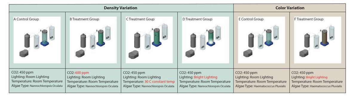
In recent years, a few examples of algae-based facade systems have been integrated into buildings due to their high ecological performance, working as a multi-functional system that reduces energy use and captures carbon dioxide (CO2). Compared with other dynamic building envelopes, the algae bio-reactive building envelope (ABBE) is a bio-driven dynamic building skin instead of mechanic. Although algae bioreactor building systems have the potential to replace existing mechanical dynamic shading, their implementation has been limited due to the high costs associated with research, development, and implementation. Much of the ABBE research has been focused on early concept exploration and feasibility discussions without developing and testing actual implementations. The only real-world built project — the Bio Intelligent Quotient — investigates algae bioreactor building envelope’s energy gain and biomass harvest. However, supporting the need for ABBEs only from the energy harvesting perspective may not be enough to support ABBE research and development at scale. This thesis discusses how algae bio-reactors react to buildings’ environments and demonstrates the significance of bio-driven dynamic shading to buildings in addition to energy.
Abstract
The goal of this research is to bring algae into cities by using algae bioreactors on building envelopes. Algae bioreactors that respond to CO2 concentration, lighting, and temperature can be used as information displays that show environmental conditions. This research uses algae’s extraordinary properties to establish a connection between environmental information and building appearance while capturing CO2, generating electricity, storing thermal mass, and providing shading for indoor environments. Moreover, shading has the great potential to help to reduce the building’s CO2 emissions and energy use.
This research studies how algae bioreactors respond to people’s living conditions — such as lighting, air (CO2), or temperature — using built prototype experiments and computer simulation. I have developed a prototype that focuses on creating algae facade color variation, which means creating interaction between algae appearance and environmental conditions. I also developed digital simulations to test how much energy the bioreactors get from solar power on a whole scale building and speculate about algae bioreactor building envelope appearance influenced by environmental factors.
The algae bioreactive building envelope is an environmentally adaptive building double skin that can indicate environmental conditions. Combining environmental data visualization and bio-driven dynamic shading strategy gives cities a new way to re-design building envelopes.


Solar Radiation Result
Solar Impact on Envelopes
CO2 Impact on Enveopes
System Diagram
Note: The work illustrated in this poster is based on the author’s master’s thesis research at Rensselaer Polytechnique Institute (RPI).
MOVEABLE SHADING SYSTEMS
Developing an Algorithm to Simulate the Energy Performance of Moveable Shading Systems
Author: Meysam Akbari Paydar
Advisers: Rahman Azari and Ute Poerschke
Affiliation: RE2 Lab, Department of Architecture, Penn State
INTRODUCTION
Building envelopes have a critical function, which is to help maintain proper interior environments under the changes of external environmental conditions. The solar radiation level and angle can fluctuate rapidly over a wide range of time. In most cases, a static control solution will not suffice. Some degree of active, rapid response to changing outdoor conditions is needed. This can be provided with a moveable shading device that is added to the glazing. This study aims to provide the possibility of evaluating the energy performance of moveable shading systems. Therefore, an algorithm was developed in Python to simulate the energy performance of the moveable shading systems. This algorithm determines the optimum position of the shading device in each time step based on indoor temperature. In addition, a moveable shading device was designed with the ability to control solar radiation entered into interior space in various conditions.
METHODOLOGY
An algorithm was developed in Python that uses the finite difference method to calculate zone heat balance. In each time step, the algorithm calculates zone indoor temperature based on shading position, which allows a specific amount of solar radiation to enter indoor space. It then compares indoor temperature with determined comfort temperature. If the indoor temperature does not meet the determined condition, the shading control algorithm changes the shading position and the heat balance calculation is repeated. This process continues until the determined condition is met. Afterward, the algorithm does the same process for the next time step.


RESULTS
The performance of moveable shading was compared with three usual fixed horizontal louvers. The difference between these three modes is in the gap between the slats (Figure 1). Moveable shading blocks solar radiation in the hours that solar radiation is high and indoor temperature is going to go above the comfort temperature. However, the first fixed mode blocks most of the solar radiation that leads to the indoor temperature below the comfort temperature. In the second and third fixed modes, the temperature is above the comfort temperature during some hours because of the high amount of solar radiation entering the building (Figure 2). Therefore, moveable shading systems can provide a better indoor environment and also lesser heating and cooling load compared to fixed shading systems.
DESIGN
In the designed moveable shading system, the position of the panels is controlled using four cables. This system not only has a high capability in controlling entered solar radiation to the interior space in different geographical directions, but also provides an appropriate outdoor view for occupants by advanced controlling strategies (Figure 3).

Figure
Note:
Climate change has become the main environmental challenge that humans face in the current century. While the advancement of knowledge and technology has improved building design and construction practices, the building sector continues to be a predominant contributor to primary energy use, operational and embodied carbon, and other adverse environmental impacts.
The research within the Resource and Energy Efficiency (RE2) Lab lies at the nexus of building physics, energy performance, environmental life cycle assessment, and industrial ecology. Broadly, we aim to understand the impact of buildings and urban systems on the environment, and develop innovative design and technologies to reverse those impacts. Our research falls into two key themes including: (1) multiscalar and multidimensional assessment of life cycle impacts of buildings on the environment, and (2) innovative building systems and technologies with energy production and carbon absorption capabilities.


MODELS TO ASSESS AND REVERSE THE ENVIRONMENTAL IMPACT OF BUILDINGS
RE2 Lab Research and Teaching
AUTHOR: Rahman Azari, Ph.D.
RESEARCH THEME 1:
Multiscalar assessment of the environmental impacts of buildings.


RESEARCH THEME 2:


Artificial leaf-based materials for energy generation & carbon absorption.


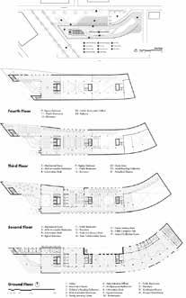
RESEARCH OVERVIEW
Climate change has a strong negative impact on Bangladesh despite the country having an insignificant carbon foorprint. With rapid urbanization, Dhaka — the capital of Bangladesh — is progressively falling short of sustaining outdoor life due to the Urban Heat Island (UHI), which is one of the most documented phenomena of urban climate change. The UHI intensity inside and around Dhaka varies from 2.5°C to 7.5°C and it is found to be highest during both the afternoon and night hours. This leads to the increased demand on the urban energy resources for cooling. The city possesses only 0.12 acres of greenery and open areas per thousand population, while it needs to devote a range between 6.25 and 10.5 acres of total open space per thousand population, according to the National Recreation and Park Association recommendation (NRPA). Therefore, adding vegetated infrastructre by planting trees in the city can be an effective solution to reduce the heat island effect in the context of Dhaka. For this study, Purbacol — a residential area of Dhaka — will be selected and through ENVI-met software simulation, the impact on the outdoor temperature will be observed by planting trees on three levels: (1) at road level; (2) in green walls on the buildings; (3) and on the green roofs. This research analyzes three interventions that can effectively reduce the UHI effect. The effectiveness of these three interventions will be analyzed to generate recommendations for the tropical city in order to re-establish outdoor life in Dhaka, where the urban spaces will be comfortable.
RESEARCH QUESTIONS
To control progressive energy demand of Dhaka City, it is required to control the outdoor microclimatc conditions in order to reduce the urban heat island effect.
The research questions of the study are:
1. What will be the urban microclimatic conditions of Purbachal after the completion of development as per the current master plan?
2. How can the addition of vegetated infrastructure in the current plan aid to mitigate the UHI? Which type of interventions work most effectively to reduce the UHI effect?
ACKNOWLEDGEMENTS
This research is supported by the Penn State Department of Architecture. Software and equipment for this study is provided by Ecology plus Design (E+D) and the Hamer Center for Community Design.
METHODS
MITIGATING URBAN HEAT ISLAND BY
VEGETATED INFRASTRUCTURE
A CASE STUDY OF DHAKA, BANGLADESH
AUTHOR: TASNEEM TARIQ ADVISER: UTE POERSCHKE , CO-ADVISER: LISA DOMENICA IULO
The new planned residential area of Purbachal has been selected to observe the impact of vegetated spaces in order to mitigate the UHI effect in Dhaka, Bangladesh. Purbachal is the biggest planned township in the country. Three interventions will be applied to increase the vegetated space percentage and their respective impacts on UHI will be analyzed. The “Leonardo Module” included in ENVI-met is capable of rendering a visual image based on the numerical output file from the ENVI-met simulation. The images will be observed and analyzed to determine the microclimatic parameters. Several variables — such as temperature, mean radiant temperature, relative humidity, and wind speed of the urban microclimate — have been identified for the research.
Stage 1:
Detailed literature review on microclimatic conditions and UHI effect on Dhaka will be done. The 3D model of the entire Purbachol area will be made for simulating in ENVI-Met software.
Stage 2:
Four major micro-climatic parameters will be observed by visual image rendered by ENVImet software.
Stage 3:
Observe the impact of vegetated spaces; three interventions will be proposed at this stage.
Intervention 1:
Several trees will be proposed at the pedestrian level in the area and impact on the urban microclimate will be observed. Intevention 2: Green roofs will be proposed on all the roofs of the residential buildings and the impact will be observed from ENVI-Met simulation. Intervention 3: Green walls will be proposed on the buildings and the impact on urban microclimate will be observed from ENVIMet simulation.
Stage 4
From the detailed observations of the simulations, some recommendations will be generated about which type of intervention can be the most effective to reduce the UHI effect in Dhaka, which can reform the design concept of the Purbachol planned area.


- This research will determine the impact of urban development on the urban microclimate once the Purbachol area is fully developed as suggested in the current master plan.
- The research will determine which type of intervention, such as planting trees at ground level or creating green roofs or building green walls, works most effectively to mitigate the UHI effect on the city of Dhaka.
- From the detailed observations of the simulations, some findings and probable concepts to improve UHI will be generated, which can then inform the design concept of the Purbachol planned area and future development in the city of Dhaka.
Detailed Land Use of Purbachal New Town Project, Source: RAJUK website
PURPOSE
This study aims to develop a literature review to identify key texts and best practices for collaborative learning in higher education settings that include evidence of effectiveness.
A large body of education research for collaborative learning is directly related to firstyear college student success. However, there appears to be very little research for effective collaborative pedagogies in the design disciplines. In addition to understanding the defining structures of successful collaborative practices, we will identify the practices for assessing collaborative work and exploring the role of social dynamics, cultural differences, and power in group-work conflicts.
Our literature review will form a framework for analyzing existing design studio pedagogies. It will also aid in developing successful collaborative practices for first-year design studio education while also accounting for the social dynamics of the shifting demographics of college students.

CONTEXT


In the field of education, research demonstrates that collaborative learning activity promotes deep learning. Students engage in high-quality social interaction, especially when discussing approaches to problem-solving and debating contradictory viewpoints and information. Collaborative learning develops critical thinking processes when students interact by explaining to, and questioning, one another critically. In addition to cognitive benefits, collaborative learning hones the essential social skills needed for citizenship and future professional work. Even with these stated educational benefits, research demonstrates that most college students are hesitant about collaboration and the benefits of group work.
In architecture and landscape architecture design, students often seek individual learning over group work while also recognizing that success in the world of professional practice relies on the outcomes of high functioning groups. The ability to work effectively as a collaborative team member is often cited as a key competency and a professional value. The design process for architects, landscape architects, and graphic designers has always been a collaborative process that involves participatory practices, multiple partners, allied professionals, and clients.
Faculty and students in design studio courses often struggle with group projects and teams that operate at sub-optimal levels or devolve into poorly functioning groups. The higher education literature identifies dysfunctional group learning as the outcome of poor group training as well as limited knowledge on the part of the faculty for structuring and managing group dynamics, assignments, and assessment rubrics. In addition, faculty report that group work is difficult to assess. Often this is because assessment focuses on the project outcomes and discerning the individual student contribution. The challenging nature of these issues taken together impacts the faculty member’s decision to not include, or greatly minimize, collaborative work in the design studio. Although collaborative skills are highly valued in the design professions, and collaborative learning has impact demonstrated impact on student success and cognitive and social development, collaboration in the design studio has proven hard to teach and difficult for faculty to assess.

COLLABORATIVE PRACTICES
A Literature Review of Evidence-Based Studies
AUTHORS: Cathy Braasch, Patricia Kucker, Danica Williams, and Sydney Yakowenko


METHODS / LITERATURE REVIEW
For this literature review, we consulted the Education Resources Information Center (ERIC) database and searched for the period of 2011 to 2020. ERIC is an authoritative database of indexed and full-text education literature. Sponsored by the Institute of Education Sciences of the U.S. Department of Education, it is an essential tool for education researchers of all kinds. While ERIC is a comprehensive database for educational research, we acknowledge that ERIC does not typically index the design discipline journals. For example, the Journal of Art and Design Education is indexed by ERIC, but the Journal of Architectural Education is not. Likewise, the Landscape Architecture Journal; Art, Design & Communication in Higher Education; and the International Journal of Construction Education and Research are not included in ERIC. Nevertheless, we believe them to be valuable journals, and they will be manually searched as part of our literature review.
We also consulted the Avery Index to Architectural Periodicals, which is published by the Avery Architectural and Fine Arts Library at Columbia University. Avery offers a comprehensive listing of journal articles on architecture and design, including bibliographic descriptions on subjects such as the history and practice of architecture, landscape architecture, city planning, historic preservation, and interior design and decoration.


PRELIMINARY OUTCOMES
Our search of the ERIC database with the broad-based grouped search terms “collaborative learning,” OR “team-based learning,” OR “cooperative learning,” OR “group learning,” for research in higher education, resulted in over 4,000 entries during the 10-year period. Some of the narrow terms such as “design pedagogy” identified only 96 entries and helped us understand how little research entries exist in this area. The terms “collaborative learning” AND “design” as a grouped search resulted in only 392 entries. When we manually searched the four disciplinary journals noted above, the result was 37 entries over the 10 years.
• Many of the entries in our large ERIC search come from the disciplines of medicine/nursing, engineering, education, and business. However, very few entries are from the design disciplines.
• Many of the entries from the disciplines of medicine/nursing, engineering, and business focus on the collaborative skills needed to be successful in the industry setting or in delivering a professional service to a client or the public.
• Many of the entries from the education disciplines promote a relationship between collaborative learning, community building, and student persistence.
• During the 10-year period, entries from the design and construction industry focused first on the need for collaboration driven by building information modeling software (BIM). Over the 10 years, the focus on technology has diminished, but the need to develop collaborative skills remains a high value.
REFERENCES
Baldwin, R. G., & Chang, D. A. (2007). Collaborating to learn, learning to collaborate. Peer Review, 9(4). Chang, Y., & Brickman, P. (2018). When Group Work Doesn’t Work: Insights from Students. CBE life sciences education, 17(3), ar42.
Dutton, T. (1987). Design and Studio Pedagogy. Journal of Architectural Education (1984), 41(1), 16-25. doi:10.2307/1424904
Newman, T. (2020). Collaboration is uncomfortable. The International Journal of Art & Design Education, 39(4), 788-794. doi:10.1111/jade.12323
Schön, D. A. (1992). The theory of inquiry: Dewey’s legacy to education. Curriculum inquiry, 22(2), 119-139. Schön, D. A. (1984). The architectural studio as an exemplar of education for reflection-in-action. Journal of Architectural Education, 38(1), 2-9.
Slavin, R. E. (1991). Synthesis of research on cooperative learning. Educational Leadership, 48(5), 71. Wright, G. B. (2011). Student-centered learning in higher education. International Journal of Teaching and Learning in Higher Education, 23(1), 92-97.

First-year students creating a collective site plan. Credit Braasch.
Students design problems together. Credit Penn State.
First-year design/build projects. Credit Braasch.
Collaborative portraits. Credit Penn State.
CELEBRATING THE WORKS OF THE GLOBAL MAJORITY
PRECEDENTS IN DESIGN
AUTHORS:
Joshua Achampong, Alisa Asare, Claudia Bowes, Cathy Braasch, Luke Scanlon, and Sydney Yakowenko
THE GLOBAL MAJORITY
The term “global majority” is relatively new and attempts to reframe our perception of racial identities. The term refers to people who have been racialized as “ethnic minorities” in Europe and North America, but who collectively represent about 80% of the global population. This project aims to celebrate the work of underrepresented designers and support and inspire students.
METHODS
To curate the projects, we researched designers of color whose works are unpublished or who have only limited digital content available. The project list is a work in progress; thus, it is not envisioned as a “best of” collection but rather an ever-expanding excerpt. Next, we invited the designers to contribute to the project and then interviewed them to learn more about their projects and experiences. Interviews are an invaluable part of understanding the designer’s perspective, and this documentation will be available to students and faculty. Finally, we acquired drawings and documentation from the designer and permission for use.
The first iteration of the project was a print publication that was disseminated in fall 2020. This book was shared only with Penn State faculty and students. The second iteration — a website that will launch in fall 2021 — creates a framework for the ongoing acquisition of new documentation. The website will be publicly available. Downloadable documents are limited to people with “.edu” email addresses. The website also provides proper citations for each document to support the fair use of all materials. Once launched, the website will continue to expand with new projects and give faculty and students direct access to high-quality images.
CONTRIBUTIONS
This project has already helped diversify studio curricula and will help a larger audience with the website’s launch. The documentation will include drawings and pictures of the projects that are not yet published or available as high-quality images. This detailed documentation will create easy access to new resources for faculty and materials equitable to other published precedents for students improving the diversity of precedents in design curricula.


RESEARCH OVERVIEW
Precedents are a valuable part of any design field, and they are an essential tool for building knowledge and gaining new perspectives on design. However, precedents used in design schools typically lack diversity and focus primarily on white designers. This imbalance discourages people of color from feeling welcome in design as they lack access to successful role models and representation. Anecdotal evidence shows improved retention and academic success for students of color who have more diverse curricula. With access to the work of these designers, students can better understand the richness and complexity of the world around them. Our goal is to create a database of precedents by diverse and underrepresented designers to support design students and faculty in their courses.
For this precedent guide, we began by focusing on the following cultural identities in North America: Black, Latinx, Asian, and Indigenous Peoples. As we continue to add new documentation, we will incorporate people from all over the world. Selected projects from these designers focus on the disciplines of architecture, landscape architecture, and graphic design. The projects cover a wide range of typologies, site conditions, and stages of completion. By covering a broad selection of projects, we hope to inspire solutions for the many different design challenges that students will encounter throughout their education.


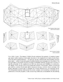


2020 print publication distributed to Penn State faculty and students.
First-year student work about Mizuta Museum of Art by Yolande Daniels, based on documentation in the 2020 publication.
Previously Unpublished Documentation: Facade Detail Axonometric 277 Mott Street, Toshiko Mori.
Previously Unpublished Documentation: First Floor Plan Page Auditorium, Julian Abele.
Website home page and example designer page.
Example project pages from website. Projects featured are Campus of Hope by Studio Luz and Mizuta Museum of Art by Yolande Daniels.
First-year student work about True North by Edwin Chan, based on documentation in the 2020 publication.
RESEARCH OVERVIEW
Rethinking the use of existing resources is one of the biggest challenges to build and sustain a resilient city. Waste collectors in urban areas cannot afford to buy highquality building materials and do not have industrial means to transform waste into resources for construction. They do have easy access to waste cardboard — one of the most abundant material components of the urban solid waste stream — by employing informal collection methods; however, they still need support to “reprocess/repurpose” this material and reuse it to complement do-it-yourself (DIY) housing construction or improvement. They also need to see waste cardboard as a useful resource and not simply as an unwanted material. In this scenario, the project could motivate communities of waste collectors —and, hopefully, people in general — to rethink the value of waste cardboard by demonstrating that it is feasible (and relatively easy) to use waste cardboard to construct durable housing.
Our SBAU 2021 Resilient Cities project combines craft-based/low-skilled methods with computational design practices and tools in the design, prototyping, and production of building elements made with sheets of waste cardboard and reclaimed wood.
We take human-made resources (waste cardboard) widely available at any urban waste stream worldwide and design opensource tools that can be transferable to people who need the technology in a similar context. The tools and fabrication methods present some degree of flexibility for adaptation to different settings. The system is efficient (low-cost production and maximum productivity), durable, easy-tomake, easy-to-use, and easy-to-maintain. The digital component of the project supports the design and fabrication process of building elements. These components mediate between the material, the building element design, and the building system. Digital tools help configure housing parts using waste cardboard sheets and generate the fabrication instructions necessary for their assembly, adding “smartness” to the lowtech system.
The system is significant for waste collectors because it will guide them to reuse waste corrugated cardboard sheets as a building material and divert materials from waste to resources for construction.
More info at: https://seoulbiennale.org/exhibition/c36
USING WASTE CARDBOARD TO BUILD & SUSTAIN THE RESILIENT CITY
AN EXHIBITION FOR THE 2021 SEOUL BIENNALE OF ARCHITECTURE AND URBANISM (2021 SBAU)
AUTONOMOUS BUILDERS COLLECTIVE (ABC): JULIO DIARTE, MARCUS SHAFFER, AND ELENA VAZQUEZ. COLLABORATOR: YUN KYUNG GAL
EXHIBITION DISPLAY AT THE DONGDAEMUN DESIGN PLAZA

BUILDING ELEMENT TYPES SHOWCASED
MOLDED BOARDS
The molds increase the density and stiffness of the waste cardboard by applying mechanical pressure to overlapped sheets of waste corrugated cardboard joined with conventional glue on each layer. The molds can produce any kind of board, from corrugated boards to compressed logs. These elements can be used as infill or to produce formwork for casting concrete.
ROLLED LOGS
Inspired by standard paper tubes used in the packaging and construction industries, the goal is to make logs that could resist a load that is parallel to its length by itself or in combination with other materials. The logs can vary in diameter and length depending on the available material. These logs can be used as panel infill to improve strength and acoustic and thermal resistance, or as a structural element in combination with wood parts.
FOLDED TUBES
This is the easiest way to transform waste cardboard sheets into building elements. Using templates obtained with a digital-based tool and a knife, the fabricator cuts the pieces and folds by hand. The example shows a triangular-shaped tube that was used as an acoustic panel for a wall or ceiling. When waterproofed, the same panels can be used as formwork for casting concrete to make decorative facades.
ORIGAMI MOLDS
Wood formwork for casting concrete is expensive everywhere. However, making the molds with waste cardboard sheets could be inexpensive, recyclable, and easy to make. In this example we used simple cardboard sheets to cut and fold origami patterns designed with a digital-based tool. We included vinyl on the top surface to waterproof the panel and reuse the mold. The result is a smooth, folded surface ideal for a decorative facade.
LAYERED MOLDS
If cutting and folding cardboard sheets is easy, layering and gluing is even easier! We made boards of 100mm thickness with layered sheets and cut them with conventional carpentry tools to make a mold to cast concrete blocks/planters. The blocks follow the traditional Korean block dimensions and the little planters can help to build a very refreshing wall-garden to cool down exterior spaces in the hot summer days in Seoul.


Left: Artwork location at the SBAU Cities Exhibition at the Dongdaemun Design Plaza. Right: Different views of the exhibition display showcasing different prototypes of cardboard formwork and concrete building elements.
Context
This research project employs a singular self-built three-axis gantry-based machine as a base for modification and testing of processes toward the development and definition of a universal building machine (U.B.M.). This machine is derived from research of the Local Orientation Manipulator’s (L.O.M.) seven degrees of freedom, 20-in. sphere of motion, and ability to participate in simulations of building assembly. As prefigured and defined by the work of Konrad Wachsmann, a UBM 1) processes material, 2) handles material, 3) fabricates components, and 4) assembles system components. In addition, universality further defines it is efficient, unskilled, mobile, scaleless, and flexible/adaptable.
Methods
The methodology utilized for this research uses the U.B.M. to create building components. These components will then be evaluated in the context of a built system and the analysis will be used to modify and improve the machine. The U.B.M. will be informed the entire time by the L.O.M. produced by Wachsmann, principles of the universal, and opensource methods of design, fabrication, and distribution.
Contributions
It is expected that this research project will make contributions to: 1) the development of automated and open-source building machines in architecture; 2) the scholarship and historical understanding of the work of Wachsmann through the digital and potential physical reconstruction of the lost L.O.M.; and 3) offer an example of a methodological approach authentic to architecture that engages scholarship in a dialogue with making.

Konrad Wachsmann’s Shift from Product to Process:
Prefiguring Automated Industrialized Building in Architecture through Developments in “Universal” Building Machines
Elizabeth Andrzejewski


With accessibility in mind, the U.B.M. is being developed according to the following guidelines: 1) minimize tools used; 2) minimize materials used; 3) fewest number of parts possible used; 4) system of templates, patterns for unskilled assembly; 5) imperial and metric version, 6) one-totwo people maximum needed to build and operate machine; 7) have the ability to be dissembled, moved, and reassembled; 8) modifiable and upgradeable; and 9) packaged for open-source distribution. The examples shown highlight this iteration process which considers available materials and efficiency. The drawing above shows the development of the transmission plate for the linear motion of the UBM. The first iteration was used to gain the proper alignment of holes. The part then evolves to avoid other components, reduce material weight, and fit on a 4” wide piece of .25” thick steel, which is a standard size and already used for other parts of the machine.

U.B.M. Project Map
IMAGE CREDIT: ELIZABETH ANDRZEJEWSKI
IMAGE CREDIT: ELIZABETH ANDRZEJEWSKI
Current iteration of the U.B.M.
IMAGE CREDIT: ELIZABETH ANDRZEJEWSKI
IMAGE CREDIT: ELIZABETH ANDRZEJEWSKI.
Historical Cotext
Between 1940 and 1960, architect Konrad Wachsmann explored the theoretical concept of an architectural universal through the joint building system and fabrication methods. By 1971 his explorations of mechanical building assembly were ahead of his time. This building machine called the Location Orientation Manipulator (L.O.M.) was developed by Wachsmann and his doctoral students John Bollinger and Xavier Mendoza between 1969 and 1971 at the University of Southern California. This machine was unique from other robotic manipulators at the time because it was developed by architects to study the kinematics of architectural building assembly. At the time, the L.O.M. was built from the most technologically advanced robotic components borrowed from the aerospace and automotive industries. It could move with 7 degrees of freedom and was used to manipulate and rotate points, lines, planes, and assemble building components.
Methods
Though the L.O.M. was lost shortly after its construction, the team was able to virtually reconstruct the machine from the dissertation of Bollinger and Mendoza, images, and video. Through the digital reconstruction, the team observed the tooling, machinery, and processes utilized to produce the individual components of the L.O.M. in 1971. This analysis is best exemplified in the virtual reconstruction of the translational component.
Significant Results
Critically, the animated recreation of the missing L.O.M. in Fusion also allowed the team to rotate and manipulate different joints on axis, resulting in a better understanding of how the machine was designed to assemble buildings. Studies of tooling, machines, and processes are important to understand the L.O.M. as a product of technologies available in 1971, as well as the mechanical capabilities and limitations. This reconstruction of the L.O.M. has produced a dimensionally accurate digital model of the L.O.M. and its motion, which had previously been inaccessible.
Konrad Wachsmann’s Shift from Product to Process:
Location Orientation Manipulator
Elizabeth Andrzejewski


Bollinger and Mendoza’s dissertation states that this part was milled out of a 4”x4”x8” block of aluminum. The team began with an image of this component and overlaid a diagram onto it to understand operations that would have been used to mill the part. Considering typical milling processes, or capabilities of a modern five-axis CNC mill, milling the translational component from an aluminum block would be processed in a very specific order, as the block had to be positioned and held in a very specific way. The rounded interior and exterior forms were not meant to be decorative but rather were formed by the rounded end mill used in a milling process.


L.O.M. Parts, Components, 7 Degrees of Freedom
L.O.M. Collage and Virtual Reconstruction.
IMAGE CREDIT: ELIZABETH ANDRZEJEWSKI
IMAGE CREDIT: ELIZABETH ANDRZEJEWSKI
CONTEXT:
In his seminal writing on Industrial Architecture, The Turning Point of Building: Structure and Design (1959, Eng. trans 1961), German architect and educator Konrad Wachsmann described the distinction between special machines and universal machines specific to the manufacture of buildings. He lists “band saws, planning machines, turning lathes and so on” as universal machines — or machinery capable of operating on a variety of materials and capable of performing a variety of operations, cut-outs, forming, shaping, etc. Universal machines, which appeared on the manufacturing scene in the 1800s, distinguished themselves through a capacity for “duplication of a great variety of shapes” while special machines, according to Wachsmann, perform a singular, specific operation (punching, stamping, forming), often using specialized tooling, such as dies, attached to the machine. These definitions are distinguished by the universal machine’s various nature and the singular focus of the special machine. In the same writing, Wachsmann lists the machine’s potential contributions to industrial building manufacture: subtractive operations (cutting, drilling), additive operations (welding, joining, fastening), and through tool making (the fabrication of dies, jigs, etc.).
Wachsmann’s design efforts in the realm of machinery include his layout work for the General Panel Corporation Factory in Burbank, California (1947), and in his development of the Location Orientation Manipulator (L.O.M.), with John Bollinger and Xavier Mendoza at the University of Southern California (196971). While his factory planning included the layout of many state-of-the-art machines that were to be used to create panel and node-based housing, the L.O.M. was developed as a single, universal “assembler” with 7 degrees of movement, “a physical tool for the control, measurement, and display of the kinematics of (building) design, production, and assembly” specific to industrial building systems. While the L.O.M. anticipated computer-controlled machinery and architectural robotics, Wachsmann did not anticipate the ubiquitous nature of CNC machinery today, nor that such machines would be scaled to industry (XL) and the DIY-er/maker (SM) and be made highly transportable in relation to the building site.
Informed by Konrad Wachsmann’s observations on architectural machinery developed for and employed in the manufacture of industrial buildings — and as part of a larger research project to develop a contemporary Universal Building Macine (U.B.M.) — the authors determined to test a CNC-based machine capable of subtractive operations, additive operations, and tool making to make parts-based housing. The choice of the CNC plasma cutter — a multi-axis gantry-based machine that can process various metal sheets and stock shapes — was determined in anticipation of a U.B.M. that will cut, weld, press, manipulate parts, and assemble. The experimental objects shown here are attempts to make common industrial house parts — brackets, trusses, columns, etc. — to inform the U.B.M. under development (see Elizabeth Andrzejewski’s Konrad Wachsmann’s Shift from Product to Process: Prefiguring Automated Industrialized Building in Architecture through Developments in “Universal” Building Machines).

PROBING THE UNIVERSAL WITH MACHINES:
EXPLORING THE POTENTIAL OF A CNC PLASMA CUTTER TO MANUFACTURE PARTS-BASED INDUSTRIAL HOUSING
MARCUS SHAFFER & ELIZABETH ANDRZEJEWSKI / Material Matters


Plasma Cut 45-degree Space Frame Bracket / Study 02 (Triangular Section)
Wachsmann, Bollinger & Mendoza’s L.O.M., A Universal Machine developed to test the automated assembly of industrial buildings.
Plasma Cut Truss / Study 01
Plasma Cut Truss Study / 02
Plasma Cut M/F Press Plates and Resultant Aluminum Node for Geodesic Construction
Plasma Cut 45-degree Space Frame Bracket / Study 01
TESTING FORMING CAPABILITIES AND MOTION CONTROL USING 3D-PRINTED WORKING MODELS
ABSTRACT
This project essentially applies mechanization and computational control to the basic concept of formwork (common to concrete and earth construction), enhancing the qualities of mobility and variability that are characteristic of contemporary single-use sheet-based formwork systems. The resulting digi-mechanical ‘‘formwork machine’’ could potentially reduce placement, setup, and breakdown costs, and address the significant worker safety issues associated with traditional handset formwork systems. Robotic formwork could simultaneously enhance the technology’s unique capacity to respond to architectural form requirements with increased digitally-driven customization and variability. Contemporary developments in creating sustainable concrete formwork systems are working to replace or eliminate sheet-based, hand-set formwork with factory-situated alternatives. This project alternatively keeps formwork on site, addressing the material and economic wastefulness associated with sheet-based formwork by evolving the current partsbased, disposable system (sheets/planking, connections, bracing, tie hardware, etc.) into a more robust robotic machine. This robotic formwork can be maintained and used repeatedly — with the extended durability inherent in construction machines — on pre-mapped construction sites, and/ or in construction environments that inhibit or restrict human labor.
Current developments in this project, detailed here, include 3D-printed working models at quarter-scale (60 casting cartridges), half-scale (eight casting cartridges), and the design and development of “walking” attachments for large-scale movements of the machine. The quarter-scale working model will be used to cast five different wall configurations (five automatic walls) made of plaster. The half-scale models will be fully mechanized, employing servo motors, Arduino, and basic coding to test motion control — set up and breakdown of the machine for casting simple shapes, such as beams, walls, and arches. The walking attachment development represents the first attempts at envisioning how this “formwork machine” could make larger movements, such as walking from a truck to the specific building site, and positioning itself on the site to receive plastic materials.


MARCUS SHAFFER / AUTONOMOUS BUILDERS COLLECTIVE
Four linked quarter-scale casting cartridges.
Sixty linked quarter-scale casting cartridges arrayed to form a linear wall (L), a linear wall w/a modulated base (C), and a modulated wall with integral columns (R).
Plan view of the machine forming Automatic Wall No. 5 — a wall with a linear base and modulated top.
Half-scale models of linked casting cartridges with the drive exposed (left and center). Six of eight 3D printed half-scale casting cartridge shells.
Design studies for walking attachment at quarter scale (L) and 3D printed swing attachment prototype (R).
ABSTRACT
Nurturing and developing creative skills and expanding a student’s creative capacity is the hallmark of learning experiences in the Penn State College of Arts and Architecture. What is creativity and how do we teach it? To answer this question, scholars, psychologists, educators, and neuroscientists have been discussing and defining the construct of creativity for more than 60 years. This study seeks to explore the theories of creative cognition and learning science to develop a framework for analyzing current, and developing new, pedagogical practices for creativity in art and design.

PROJECT DESCRIPTION
For students in the creative fields of design and the fine and performing arts, their college education is defined by a learning experience that relies on cycles of reflexivity to execute creative solutions to complex and ill-defined problems, or to develop an artistic body of work that is compelling to the eye, ear, and emotions. This educational journey requires developing personal awareness, motivation for critical inquiry, goal-oriented behavior, and perseverance. These essential behaviors are a framework for attaining disciplinary knowledge and a prerequisite for cultivating creativity. As educators in the college, we are accomplished creative practitioners but few of us are trained to be teachers. Few are trained to teach students to be creative.
CREATIVE COGNITION
LEARNING SCIENCE AND PEDAGOGY FOR CREATIVITY
PATRICIA KUCKER
RESEARCH CONTEXT
Creativity has been a topic of discussion and of research in the field of psychology for approximately 60 years. Psychology is the parent discipline of education, and education often takes its definitions from psychology. Psychology, which is the scientific study of mental operations and behavior, asks, “What makes people creative? How can creativity be enhanced? What happens in the mind while a person is creating? What are the conditions for creative production? What inhibits creative production? What does the social setting contribute to creativity? Is creativity a solitary or community activity?” All of these, and more, are questions psychologists have sought to study with regard to creativity. Creativity research in psychology considers four interrelated streams: the process, product, person, and the environmental influences (Piirto, 2011).
Creativity and human creative behavior is rooted in cognition (Runco, 2014, Bass, et.al, 2015). Cognition refers to the mental processes involved in gaining knowledge and comprehension. Research in the field of cognition focuses on thinking skills and intellectual processes, such as higher order skills for learning that include judgement, perception, planning, and memory.


There are fertile connections between basic cognitive and metacognitive processes, and information processing and creative problem-solving, as well as connections with intelligence, judgement, and language development (Runco, 2014). The field of creative cognition is multi-disciplinary and offers schema for understanding the cognitive processes underlying the range of human creativity.
This study is focused first on a literature review for ‘creative cognition’ to articulate and inform pedagogical practices. This review includes the early work of Spearman, Guilford, Torrance, and Mednick, with a focus on the contemporary scholar and psychologist Mark Runco, Ph.D. Runco’s research has led to the componential theory of creative cognition that takes into account the multi-stage stage and flexible cognitive processes for creative problem-solving. In addition, this study will identify evidence-based research for pedagogical practices in art and design that target the development of creativity. Furthermore, this study seeks to connect the model of creative thinking present in learning science to new pedagogies for art and design education. Dr. Marcela Borge, College of Education, may be a good partner to include as her work focuses on cognition, learning and design. https://ed.psu.edu/ directory/mbs15.
REFERNCES
Baas, M., Nijstad, B. A., and De Dreu, C. K. W. (2015). Editorial: “The cognitive, emotional and neural correlates of creativity.” Front. Hum. Neurosci. 9:275. doi: 10.3389/fnhum.2015.00275 Csikszentmihalyi, M. (1999). “Implications of a systems perspective for the study of creativity,” in Handbook of Creativity, ed. R. J. Sternberg (New York, NY: Cambridge University Press), 313–335. Kaufman, J. C., & Sternberg, R. J. (Eds.). (2010). The Cambridge handbook of creativity. Cambridge University Press. Kozbelt, A., Beghetto, R. A., & Runco, M. A. (2010). Theories of creativity. Piirto, J. (2011). Creativity for 21st century skills. In Creativity for 21st Century Skills (pp. 1-12). -SensePublishers. Runco, M. A. (2014). Creativity: Theories and themes: Research, development, and practice. Elsevier.
FLUDDS DIAGRAM OFTHE MIND, Image credit:
Utriusque Cosmi, Tom. II, Tract. I, Lib. X
Images are from a lecture titled: CREATIVE COGNITION. The lecture presented connections between metacognition and creative problem solving behaviors. Image credit: Patricia Kucker
ABSTRACT
Studio-based learning is a highly regarded educational model in art and design schools that relies on social and collaborative teaching and learning. As a result, distinct cultures develop in art and design studios, and these cultures impact student success. Following a successful 2015 recruitment initiative led by the College of Arts and Architecture, the enrollment of students of color increased. Preliminary data from the Stuckeman School reveals that students of color leave the School at a much higher rate than their white peers.
This study focuses on the experiences of students within the unique studio environment. Through qualitative interviews with students, faculty, and alumni and quantitative results from the College Student Persistence Questionnaire1 (CPQ v.3), the outcomes of our study will lead to an action framework for improving racial equity, inclusion, and retention of Black, Indigenous, and People of Color (BIPOC) across the Stuckeman School and School of Visual Arts.

PROJECT DESCRIPTION & SIGNIFICANCE
The United States is recognized as being a racially and culturally diverse society; however, many of our public institutions continue to be structurally racist. The institution of higher education of which we are a part is implicated. The thousands of creative professionals that shape and have shaped the physical environment, defined the essential forms of communication, and expressed society’s complexity and aspirations through the arts are overwhelmingly White. The culture of art and design education across the country continues to focus on western traditions. We know this history, admit our circumstance, and seek ways to change.
Education is the primary vehicle by which society consciously replicates values and norms across generations.2 Preparing artists and designers to be ethical practitioners and professionals capable of creating and serving just societies begins with the students we recruit, enroll, and retain. Our efforts to create learning environments that value diverse opinions, gather divergent perspectives, and create spaces of empathy between and among people from different life experiences must be mindful acts. Such intentionality is needed to educate a generation of designers and artists to be prepared for their future world.
THE IMPACT OF STUDIO CULTURE
ON STUDENTS IN SCHOOLS OF ART AND DESIGN
(PI) Wanda B. Knight, Ph.D., Associate Professor of Art Education, African American Studies, and Women’s, Gender, and Sexuality Studies (co-PI) Patricia Kucker, Ed.D., Teaching Professor of Architecture
Cathy Braasch, Assistant Teaching Professor of Architecture; first-year faculty
Marc Miller, Assistant Professor of Landscape Architecture
Joel Priddy, Associate Professor of Graphic Design
Angela Rothrock, Ph.D., Associate Teaching Professor and Academic Adviser
The student’s perception of the institutional commitment3to their success, the student’s self-efficacy, and the student’s sense of belonging and involvement are the primary factors behind why students leave the program they chose to attend.
To claim our responsibility for educating the next generation, we must more fully understand who our students are and how our approach to their education, and our commitment to their success, is understood by our students. We need to understand why students choose to attend and why they leave, and what we need to do to improve our commitment to their success in order to better serve and retain our students.
Our study is focused on the studio learning environment in art and design education. A studio is a physical place, a learning community for students, and a constant presence in the curriculum and in professional practice. Studio pedagogy offers both formal and informal cohort learning opportunities, one-to-one faculty contact, and also fosters a social dynamic that cultivates the norms of disciplinary practices. Studio-based learning is defined by the community of learners that work together or adjacent in the studio and learn from each other’s work in progress, opinions, and experiences. Our study will focus on the student’s perception and experiences in the social learning environment of the studio community and the impact of this environment on the attrition and retention rates of BIPOC students.
The literature informs our study on student retention models that considers the student’s transition and success in the first year of college. For 50 years, multiple studies have focused on identifying the primary reasons why students leave the program they chose. Three factors are often found in the literature: the student’s perception of the institutional commitment to student success, the student’s self-efficacy, and the student’s sense of belonging and involvement. These three factors will form the basis of our mixed-methods research study that will include quantitative survey data and demographics, and qualitative data from student interviews and focus groups.


RESEARCH QUESTIONS
1) What are the pre-entry attributes/demographics and institutional experiences of the enrolled undergraduate students that suggest departure during or after the first year?
2) What perceptions do undergraduate students and faculty have about the role of studio culture in student success?
3) Is the studio culture in visual art education different than in design education? How are these differences defined?
REFERENCES
Berger, J. B., & Braxton, J. M. (1998). Revising Tinto's interactionalist theory of student departure through theory elaboration: Examining the role of organizational attributes in the persistence process. Research in Higher Education, 39(2), 103-119. Braxton, J. M., & Hirschy, A. S. (2005). Theoretical developments in the study of college student departure. College student retention: Formula for student success, 3, 61-87. Dutton, T. A. (1987). Design and studio pedagogy. Journal of architectural education, 41(1), 16-25.
Kuh, G.D., Kinzie, J., Schuh, J.H., & Whitt, E.J. & Associates (2005). Student success in college: Creating conditions that matter. San Fran cisco: Jossey-Bass.
Kucker, P., Martiros, M. (2019) Institutional identity and retention in an affinity bonding model. [Unpublished doctoral dissertation]. Vanderbilt University. National Student Clearing House Research Center (2020). First year persistence and retention 2018 beginning cohort. Tinto, V. (2017). Through the eyes of students. Journal of College Student Retention: Research, Theory & Practice, 19(3), 254-269. United States Census Bureau (2019). Quick facts. https://www.census.gov/quickfacts/fact/table/MD/RHI225219. United States Department of Education (USDE, 2018). Institute of Education Sciences, National Center for Education Statistics. Undergraduate Retention and Graduation rate. https://nces.ed.gov/programs/coe/indicator_ctr.asp.
1 Davidson, W. B., Beck, H. P., & Milligan, M. (2009). “The college persistence questionnaire: Development and validation of an instrument that predicts student attrition”. Journal of College Student Development, 50(4), 373-390. The CPQ was designed to identify students at risk of failure and comprises six scales: Academic Integration, Social Integration, Support Services Satisfaction, Degree Commitment, Institutional Commitment, and Academic Conscientiousness.
2 Gutmann, A. (1987). “The purposes of higher education.” A. Gutmann, Democratic Education, 172-193.
3In this study, the “role of the institution” is reflected in the student’s perceptions of the university and the school, the faculty and student peers, the advisors and the curriculum. The student’s formal and informal experiences in the studio are impactful to a student’s perception of the institution’s commitment to their success.
RESEARCH CONTEXT
Earthbag construction, also known as flexible form rammed earth construction, takes advantage of the sandbag’s capabilites to contain and support the earth as it is compressed and hardened.
However, when compared to other earth construction techniques, earthbag construction is not as robustly tested. A lack of building regulations and safety requirements pertaining to earthbags consequentially restrict its application in non-code zones. Furthermore, since its formal conception in the 1990s, earthbag construction has not significantly progressed beyond being regarded as a container for earth.


EARTHBAG EXPLORATION
In conventional earthbag construction, the bag — typically a 18” x 30” sack or continuous tube — can be transformed into different configurations with the help of supplementary tools. A sack-shaped earthbag, for example, can transform into a key for an arch when tamped into a wedge box. Similarly, a tube-shaped earthbag can be laid and compacted on top of a solid formwork to create a continuous arch. In summary, there are two primary elements to earthbag construction: the initial bag and the customizing tool.
Conversely, what would earthbag construction look like if, in lieu of the customizing tool, the earthbag was to be the customized element instead?
This study approached this question by using the sewing machine as a tool to customize the earthbag prior to the earth-filling process of earthbag construction. The overaching goals of the study thus included the following: (1) to improve earthbag accessibility in craft, (2) to optimize or improve the earthbag as a module for carrying earth, and (3) to revisit the craft at the scale of the earthbag.
RE-EXAMINING SEWN EARTHBAG
GEOMETRIES AND THEIR IMPACT ON STRUCTURE AND CONSTRUCTION WORKFLOW
AUTHOR: TIFFANIE LEUNG, ADVISERS: MARCUS SHAFFER & DK OSSEO-ASARE, COMMITTEE: FELECIA DAVIS & ESTHER OBONYO
ABOVE: Hypothetical Labor and Safety Risks Pre- & Post-Customization.
LEFT: Ways that Polypropylene Bags Transform in Conventional Earthbag Construction.
GREYED SECTION: Ways that Polypropylene Bags Transform in Sewn Earthbag Construction.


ABOVE: SURPRISE STAR: 4-to-3 point manipulation
EMBEDDED STICK MOD: Adding stiffness to the polypropylene surface
HEXAGON PROTOTYPE:
BI-CINCH PROTOTYPE: Unfilled
BI-CINCH PROTOTYPE: Filled and cinched
BI-CINCH PROTOTYPE: Filled, cinched, and propped
WHITE AFTER DARK
The Story of a Sundown Town
Blake Thresher
Abstract
“White After Dark” is an animated story depicting the formation of a fictitious Sundown Town. The project uses storytelling to contrast the different experiences of residents in the town and highlight their hidden history. A similar sequence of events occurred in towns across the country between 1890 and1940. A Black resident was accused of a crime. Panic spread throughout the White residents of the town. Finally, the White residents drove out the Black residents of the town. In many cases this was a violent process, often leading to the burning down of Black homes or lynching of the accused. The White residents were seldom held accountable for their crimes. After expelling the Black community, they passed ordinances, hung signs, and threatened violence to keep their town all-White.


Design
The design works alongside the story. The old man’s character design is formed from a shifting texture of white paint. This is both a visual representation of the lies he tells during his narration and the history of Sundown Towns in America. The flashbacks, which show the viewer the truth, are more detailed and substantial. They are formed from rigid shapes and gritty textures to make them more substantial than the lies of the old man.
Outcomes
Using a universal set of events allows the story to become a summary of how Sundown Towns formed and became obscure. The use of story forces the viewer to empathize with the characters. Even though the events are generalized, they become specific as characters move through them. Juxtaposing the narration against the truth forces viewers to assess the event on their own and hopefully draw their own conclusions.
The title lettering is based on signage from the period. The name “Sundown Town” was derived from the signs placed outside towns warning Black travelers to leave before dark.
The color is based on Home Owners’ Loan Corporation Security Maps, which contributed to segregation and were contemporaneous with Sundown Towns. The colors were adjusted slightly to increase contrast.
Still Images from Final Animation


SUNDOWN TOWNS - DATA GATHERED BY JAMES LOEWEN. IMAGE BY BLAKE THRESHER
“MAPPING
Overview
The COVID-19 pandemic has changed work environments. Many employees have worked from home, alone, and in independent offices for approximately one and a half years. These days, many companies request that employees return and prepare for new office environments; however, several potential situations are anticipated. Their colleagues may feel unease to the pandemic, which may lead to difficully communicating when it comes to work tasks. This problem will impact both large and small companies; however, small business will feel the burden more since they have faced many challenges to survive during pandemic (e.g., reducing business size, closing offices, decrease in business partners). Therefore, our team focuses on a shared office for a small-sized businesses (e.g., startups) and suggests design solutions to effectively communicate, enhance, and reinforce the common shared beliefs and behaviors that bind the individuals to an organization.
CoPort is a hypothetical shared office brand that is located around the world; thus, CoPort supports a flexible workspace where members can visit CoPort from wherever they are located. CoPort provides space and service to people who are freelancers, run small companies, and look for business partners. To support CoPort members’ successful communications and build a unique culture of CoPort, we provide a “Welcome on board” kit. A Blue Container that contains: 1) instructions on how to set up the display; 2) Port Pass (membership card); and 3) an individual’s business card.
More specifically, the Blue Container is a multi-purpose device that can be used as a power bank, digital signage, and nameplate. CoPort members can bring the Blue Container anywhere to charge their devices, indicate their workspace, and present their personal identity, including their name, business size, business area, position, personality, role with visual elements (e.g., color, pattern), their daily life, or business motto. The most significant benefit of the Blue Container is to provide a flexible work environment. Members can move around in space easily without seeking a power outlet. In addition, information on the display can be a starting point of conversation to make personal and business relationships at CoPort. When members leave CoPort, they should return the Blue Container for sustainable use. Accordingly, CoPort provides creative design solutions to support small-sized businesses in terms of enhancing communication, sharing and exchanging experiences and knowledge, and building new networks.
Welcome Kit for CoPort
A design solution for integrating the artifacts that communicate, promote, and reinforce the common shared beliefs and behaviors that bind the individuals to an organization in a shared office.


Huiwon Lim (Principal Investigator), Yongyeon Cho, Hye Jeong Park

ABSTRACT
It’s hard to imagine a world without pollinators. They help in the fertilization of plants, which results in seed and food production. However, the pollinator population is declining at a rapid pace. Thus, recognizing their importance and supporting their population by planting pollinator-friendly flowers is very crucial.

DESIGN SYSTEM
To build a more cohesive visual design language, several experiments were done to develop a visual vocabulary that can portray data based on its meaning. The idea was to use a flower form so that the theme of the visualization can be easily understood even from a distance (Fig. 4). Using floral shapes as the primary element helped to develop a visual language which could represent diverse data effectively. Other elements were then created to enhance this narrative. Motion was used as a means to attract the attention of the people and make it visually more interactive. It acts as a switch between human vision and bee vision of the flowers.
A BLOOMING STORY
A data visualization designed for a digital screen at the Penn State Library.
Shatakshi Mehra
RESEARCH OVERVIEW
Humans, like other primates, can see the tones of the color red, which bees cannot. Instead, bees can see the ultra-violet colorss that help them to find nectar-rich flowers and navigate around the flower world. This data visualization shows the difference between how humans see the color of flowers versus how bees see them while at the same time representing top pollinator-friendly flowers in State College. The project aims to explore a way in which data can be represented to influence the user’s behavior.

Initially, the visualization represents how the flowers would look in the eye of a human (Fig. 2). But gradually as the bee flies towards a flower, the visualization switches to depict how the same flowers will look in the eye of a bee (Fig. 3).


Figure 3: Final design (Representing Bee eye version).
Figure 4: Floral shapes for representing data
Figure 1: Final design in the library space
Figure 2: Final design (Representing Human eye version).
BACKGROUND
In China, climate change and the rapid conversion of rural lands and people into urban environments have brought a wide range of challenges, including the drastic deterioration of the nation’s water environment. Severe flooding and water quality impairment have become one of the most pressing environmental issues in recent years. The Sponge City Development (SCD) initiative was launched in 2014 to address severe urban flooding and water quality challenges in China. Green stormwater infrastructure (GSI) such as rain gardens (Fig.1) have been adopted as critical stormwater management tools. GSI can provide a series of environmental and social benefits to the public, such as stormwater infiltration and purification, educaitonal and recreational opportunities, and aesthetic value.

METHODS AND CONCLUSION
Existing research has focused primarily on the environmental performance of GSI, which overlooks the human dimensions. In particular, the co-benefits of GSI perceived by the public have been particularly underinvestigated. We used questionnaire surveys (n = 607) and expert interviews (n = 11) to explore public perception of the SCD and GSI in four pilot sponge cities: Jiaxing, Zhenjiang, Pingxiang, and Chizhou (Fig.2). The study reveals the limited services that GSI effectively provided in SCD. We recommend the following: 1) National and local policies for SCD implementation and assessment need to incorporate social goals and long-term maintenance requirements (Fig.6); 2) Enhancing GSI benefit provision requires significant advancements in professional knowledge, technology, and innovations (Fig.5); and 3) Co-benefits of GSI need to be considered at both the watershed and site scales to fully utilize GSI as a placemaking tool to create more sustainable and livable urban communities.
Public Perception of Ecosystem Benefits of Green Stormwater Infrastructure
A Case Study in Chinese Sponge Cities
Author: Rui Wang, Ph.D. Candidate, Landscape Architecture Adviser: Hong Wu, Assistant Professor, Landscape Architecture
FINDINGS


The survey found that 74% of respondents experiened flooding issues. They were not very familiar with GSI (mean = 3.18), and held overall strong institutional trust (mean > 4). The Friedman test revealed that respondents were more concerned with quality of life and life and property safety than water quality and ecosystem health (p<.001). Respondents showed significant highest trust on effectiveness of agency collaboration than the other four aspects of trust (Fig. 3). Perception of the health and aesthetic values were the top two strongest benefits, whereas water quality improvement and noise mitigation ranked at the bottom (Fig. 4c). Regression found that people who have more GSI experience, higher level of familiarity, higher concern, higher trust, and are in older age are more likely to perceive ecosystem benefits provided by GSI (Table 1).


Fig. 1: A rain garden in a pubic park, Pingxiang, China. Image Credit: Rui Wang
Fig.
Fig.
Fig. 6: Maintenance and user-related problems found in sponge transformed neighborhoods.
Bistable kinetic shades:
Actuation studies with Shape Memory Alloys and prototype development.
ELENA VAZQUEZ, JOSÉ DUARTE
INTRODUCTION
Elastic instability is not traditionally considered a desirable feature for building components. Nevertheless, it has recently gained attention in kinetic architecture research to replace complex mechanical systems with bistable solutions. This study aims to develop a methodological framework for designing bistable shading screens actuated with smart materials. This poster focuses on the actuation component, optimizing the holder unit mechanism for efficiency and aesthetics. The actuation component relies on a string system and is actuated with Shape Memory Alloys (SMAs).

This study adopts a case study methodology to develop a bistable kinetic shading system actuated with SMAs. The approach was chosen to allow for deeper insight into the challenges and opportunities in designing a kinetic system with these materials. The case study is the design of a shading system for an office building, located in State College, Pennsylvania. The screen is intended to help improve daylight control in buildings. Several quantitative and qualitative methods are used throughout the process of kinetic screen development, complementing the case study approach, to ensure a balance between efficiency and aesthetics.
RESULTS
The main unit or holder of the system was developed in iterative loops, keeping track of the improvements of the design in terms of aesthetics and simplicity of the system. Figure 2 shows the different iterations of the holder, noting the improvements on each step. Once the main schema for the holder was defined, we sought to optimize the string path used to actuate the bistable flaps. Therefore, we measured the force needed to snap through with a force gauge, in order to assess if commercially-available SMA springs exerted enough force to actuate the flaps (Figure 3).
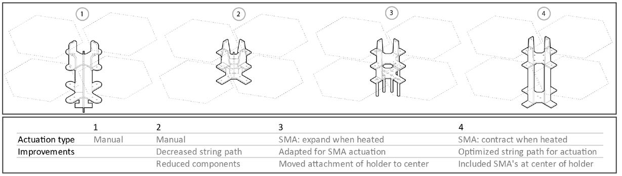


Figure 4 shows the final design. The holder mechanism is comprised of the bistable flaps, the strings that are used to pull the bistable flaps, and the shape memory springs. The two-way shape memory alloy contracts when heated above 55 degrees Celsius, contracting to 16mm, and extends back to 50mm when cooled down.
FUTURE WORK
* Study the feasibility of embedding SMAs into the bistable flaps.
* Explore automation of the shading system by using custom-made SMAs that actuate at operation temperatures (40 Celsius).

Figure 1: Bistable shading system. METHODS
Figure
Figure
Figure
THE PANAM NAGAR GRAMMAR:
A SHAPE GRAMMAR TO ANALYZE THE COLONIAL HOUSES AND URBAN SETTLEMENT AT PANAM NAGAR,
BANGLADESH
AUTHORS: ENAM RABBI ADNAN, HEATHER LIGLER, JOSÉ DUARTE, DENISE COSTANZO, MADHURI DESAI
RESEARCH OVERVIEW
Panam Nagar is an early 19th century colonial settlement in Bangladesh. It was a famous trade center for clothes and crafts built by the merchants who presumably lived and worked there, and their colonial houses are the jewel of the site. Today, the settlement is dilapidated and needs preservation. The Government of Bangladesh has declared Panam Nagar a national heritage site, but budget constraints and other limitations have delayed conservation efforts. Before conservation or adaptive reuse, a thorough understanding of the site is necessary. Formal analysis provides a basis for successful historic preservation by contributing knowledge on the space and structure of the colonial houses, and their role within the urban settlement. Previous research has dealt with ornamentation, documentation, and spatial understanding of Panam Nagar using space syntax. To develop a further spatial and morphological understanding of the settlement, this research will use the shape grammar formal methodology to study the inherent spatial quality of the consolidated-type houses. More specifically, the Panam Nagar Grammar aims to shed new light on our understanding of the settlement by unpacking how the houses support a merchant lifestyle characterized by domestic and commercial functions. Shape grammars have been widely used to analyze different architectural precedents and bring understanding to their spatial character. Future research may incorporate the remaining houses to provide an over-arching preservation or rehabilitation plan by building on the Panam Nagar Grammar.
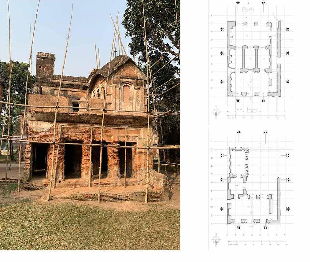
FINDINGS

RULES


The rules to describe the houses of Panam Nagar (Source - Author, 2021)
DERIVATION

METHODOLOGY
This research starts with understanding the characteristics of the Panam Nagar houses and the settlement through a literature review. The methodology then proceeds with the development of a shape grammar. More specifically, this process includes developing rules to analyze the existing houses at Panam Nagar spatially and formally to interpret their development, building elements, and structure. In this study, consolidated-type residential buildings will be analyzed as the basis for a more comprehensive understanding of the site. Based on the findings of the grammar, the study theorizes the living pattern of the past inhabitants of Panam Nagar.

development and incremental growth of the spaces. (Source: Author, 2021)
This research through shape grammar shows the backyard facade was equally important. The facade, which has a semi-public or semi-private character, plays an important role in day-to-day domestic life. Secondly, through the discussion of the shape grammar of the consolidated houses, it is also evident that the houses have a multifaceted and concentrated core at the middle part of these structures. The public living spaces at the front of the houses and semi-public internal rooms at the back are simple in nature. Thirdly, the grammar and study also pointed out that the circulation pattern modifies with the incremental growth of spaces and needs to move higher to the second story. Though shape grammar has been used widely to analyze the architectural precedents, this study is a part of understanding the development of a particular traditional housing system that is not analyzed using the shape grammar formalism and aims to expand the grammar as a basis for a larger conservation effort at the site.
The plans of number 13 building of Panam Nagar. Plans are collected from the Archeology Department of Bangladesh. (Source: Author, 2020)
Figure: Aerial View of Panam Nagar showing the historic area (Source - Dipu Sarker, 2020)
The
The derivation of the ground floor plan of the house number 13 using the rules. (Source: Author, 2021)
WHY MEASURE SPATIAL ABILITY?
This study attempts to redefine the manner in which virtual reality (VR) is used by architecture students by developing a new model of digital design education and research: a model that takes advantage of the capabilities of the medium, without limiting the design process or trivializing the new technology. As directly measuring VR’s impact on design education is not easily quantified, it was necessary to identify a surrogate process to assess.
For architecture students, an important spatial ability is the capacity to generate three-dimensional knowledge from twodimensional information. Therefore, spatial ability is an inherent component of design education and, for that reason, this study used it as a surrogate to be measured when assessing VR’s impact on architecture design education.


MEASUREMENT:
For the pilot study, only the the Purdue Spatial Visualization Tests: Visualization of Rotations (PSVT:R) was administered to the sample group prior to, and immediately after, training in order to assess the impact of using digital tools in immersive environments. For the final research project, the Mental Rotation Test (MRT-A) will also be part of the pre-/ post-test.
These instruments are used to measure performance in aptitude and evaluate improvement. The tasks performed during these tests functioned both as part of the spatial learning process typically taught in design studios, and to evaluate the effect of VR on that process.
VIRTUAL REALITY IN DESIGN EDUCATION
Evaluating the Impact of Immersive Technology on Spatial Ability Development in Beginning Architecture Students
AUTHOR: Eric Mainzer
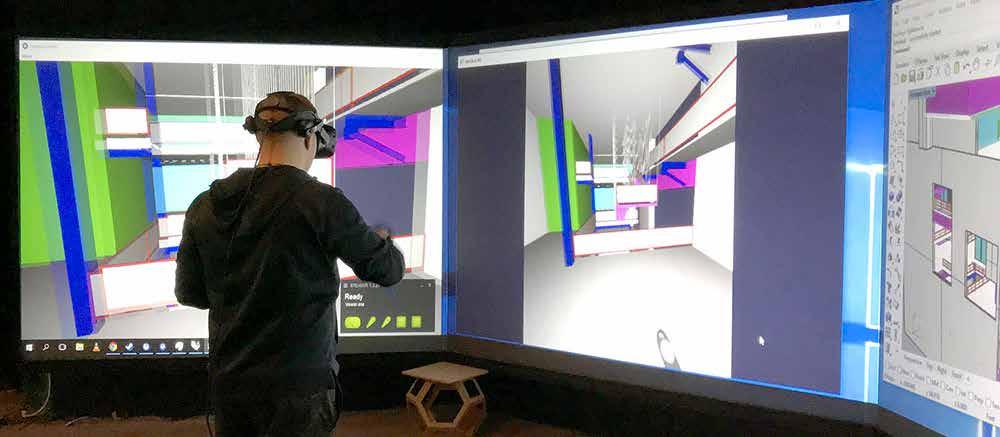
RESEARCH OVERVIEW
This study investigates the pedagogical impact virtual reality (VR) has on design education for beginning architecture students by examining how VR affects spatial visualization skills (SVS) development. In order to examine the effects of VR, a pilot study was conducted in the spring of 2018 to evaluate the training, experimental method, and testing procedures and instruments that could be used in a future study. We compared the SVS performance of eight first-year architectures students who used VR to complete mental-rotation exercises with four first-year architectures students who completed the same exercises sketching on paper.
The results indicated a correlation between intervention training and improvement from pre-test to post-test, suggesting a change in mental rotation abilities. Participants using VR completed the exercises more successfully than the group sketching on paper. However, the paper-sketching group showed greater improvement in the pre-test/post-test scores indicating spatial ability training, problem solving, and cognitive benefits experienced in an immersive environment might not translate to real-world situations. The goal of the exploratory study was to better understand the impact that VR might have on architecture design education through an evaluation of its direct effect on spatial visualization skills in beginning architecture students. The results of the study emphasize the need for adequate sample sizes and while the study did not yield statistically significant results, it does offer a suitable framework upon which future research can be built.


DISCUSSION AND STUDENT FEEDBACK

Mental Rotations Test (MRT-A) (Peters, 1995) and Purdue Spatial Visualization Test: Visualization of Rotations PSVT:R Question (Guay, 1976)
Immersive sketching and problem solving in Virtual Reality.
Environment manipulation in VR to solve drawing tasks.
Manual reconstruction of 3D by 2D mapping onto a cube.
STUDENT CREATING AND EVALUATING THEIR DESIGN USING VR IMAGE: ERIC MAINZER
VISION
In this study, a framework is introduced by which the idea of the circuit is taught through the development of a responsive and craftbased circuit game. Composite textiles are used as an interface for developing complex geometries and embedding sensing with the focus on interaction through materiality, design configurations, and decision-making in responsive systems. The goal is to discover how a responsive game-based system can be conceived and designed, and how this method of design can enhance the design process and encourage human participation in developing design alternatives.

STEPS
The main steps of the research are:
1. Determining the game elements.
2. Eleborating characteristics of the circuit game.
3. Validating the responsive system developed.
MAIN GAME ELEMENTS
- Game (Rules, Codes, System)
- Gamer (Users, Participants)
- Gaming (Interaction, Storytelling)
CHARACTERISTICS OF CIRCUIT GAME
• Base Materials (Materiality): Composite textiles as the game interface.
• Making Process: Developing individual elements of the game.
• Assembly Process: Attaching and detaching game elements.
VALIDATING/RESULTS
A framework developed by Giaccardi and Karana (2015) is used to analyze the material experience pattern of the craft-based responsive game developed in this study. This framework defines the link between the aesthetics of design — sensorial, interpretive, and affective level — as well as the performances that are carried out with and through its materiality (performative level).
• Sensorial: Soft/solid textile, familiarity with material, characteristics of different textiles (woven, knittted)
• Interpretive: Different methods of connections and configuratins
• Affective: Playfully engaging participants
• Performative: Educating new concepts, decision-making processes, and adding to design space.
A CRAFT GAME-BASED RESPONSIVE ARCHITECTURE
FARZANEH OGHAZIAN, FELECIA DAVIS
(Paper will be presentated at Design Communication Association: Perception to Execution 2021 conference)
DETAILS
In this practice, initial components are defubed as responsive elements. However, the way to achieve response is dependent on the users and how they aggregate components. The final design results are dependent on the materiality of the game components, the structure of the whole system and the decisions users make to connect pieces.


CONTRIBUTION
The main contribution of this research is a framework for generating responsive architectural designs through a game-based architectural system. This framework provides users with the minimum requirements and invites them for active participation to develop different methods of aggregation to get a response from the system. The applicability of this framework is explored in the shape of a smallscale game; however, the concept can be applied across different scales, from a game for kids to a partition wall and buildings.

RELATED PUBLICATIONS
Oghazian F., Davis F. (2020) Circuit Game. In: Streitz N., Konomi S. (eds) Distributed, Ambient and Pervasive Interactions. HCII 2020. Lecture Notes in Computer Science, Vol 12203. Springer, Cham. https://doi.org/10.1007/978-3-030-50344-4_45
Figure 1: Conductive fibers embedded in composite felt textile and specific pattern configuration to avoid short circuit.
Figure 2: Materials used for developing game elements. Knitted textile, Felt, Glass Fiber, and Carbon Fiber
Figure 3: Details of the joints for connecting pieces.
VISION
The authors present an optimization-based calibration process for tuning a digital form-finding algorithm to aid in the design of knitted textile materials in architectural tension structures. 3D scanning and computational optimization tecniques are used to approximate a physical model in a digital workflow that can be used to establish model settings for future exploration within a knit geometric typology. Two optimization plug-ins in Grasshopper, known as Radical and Opossum, are investigated for different types of data extraction. The goal is to determine the appropriate optimization tool, data extraction, and form-finding settings related to the length and strength of the meshes that are associated with the knitted textile structure and behavior.
STEPS
The research consists of three main steps:
1. Extract data from 3D scanned model.
2. Determine the bounds of formfinding settings.
3. Define the optimization variables, constraints, and objectives and run the optimization process.
The objective for the optimization process is to minimize the cumulative distance between the points from the form-found model and 3D-scanned model. Different strategies of extracting points from both models were examined and the important points are hierarchically weighted.
NEWS/RESULTS
The results show that using all the points extracted form the form-found model is not necessarily a good approach regarding the calibration of the digital formfinding algorithm. Reducing the number of data enhances the optimization process. The combination of data, such as the four critial points in the transformation area and points from the main sections of the conic models, gave us a closer shape to the physical model. Additionally, some algorithms in Radical — such as GN_Orig_Direct_L — and in Opossum — such as CMAES_Random — are giving us a better overall shape compared to other algorithms.
CONTRIBUTION
The main contribution of this research is tuning the digital models of architectural knitted textile structures. Another contribution is a system to generate reliable data without physically making models. This is important because by using these data, we can then generate machine learning models that could predict the shape and behavior of knitted tension structures.
RELATED PUBLICATIONS
Oghazian F., Farokhsiar P., Davis F. (2021). A simulation process for implementation of knitted textiles in developing architectural tension structures. International Association for Shell and Spatial Structures Conference.
CALIBRATING A FORM-FINDING ALGORITHM
FOR SIMULATION OF KNITTED TENSION STRUCTURES
FARZANEH OGHAZIAN, NATHAN BROWN, FELECIA DAVIS
DETAILS OF THE OPTIMIZATION PROCESS


ACKNOWLEDGMENTS
The authors are grateful for the support of: ICDS Seed Grant 2021-2022 SCDC Interdisciplinary Grant 2021-2023
Figure 1: 3D-scanned model (left, blue colors), form-found model (middle, red colors), and an illustration of two models overlapped (right).
Figure 2: Calibration using all the points from form-found model. This is a straight-forward strategy, but a computationally expensive process. Therefore, other extraction methods are examined to enhance calibration process. The blue colors are from the 3D-scanned model and the red colors are associated with the form-found model.
Figure 3: Different data extraction methods to simplify and speed up the tuning process are shown. Random points at left, four critical points in the middle, and points from main sections of the model at the far right. We also examined a combination of these strategies.
Figure 4: One of the data extraction methods using different optimization algorithms in Radical and Opossum (Four weighted critical points and points from section lines)
RESEARCH OVERVIEW
The novel coronavirus (COVID-19) pandemic is an unprecedented global event that has been challenging governments, health systems, and communities worldwide. Available data indicates varying patterns of the spread of COVID-19 within American cities, especially in the first few months of the pandemic when the spread was faster in high-density, walkable cities, such as New York, than in low-density, car-oriented cities, like Los Angeles. This work investigates the hypothesis that urban configuration and associated spatial use patterns directly impact how the disease spreads and infects the population. This paper addresses the first 60 days of contagion — when containment measures had not yet entirely influenced the spread — in 93 counties in the United States, considering data regarding population size, population density, walkability of the city, and the number of confirmed cases and deaths. Our findings indicate correlations between walkability, population density, and COVID-19 spreading patterns but no clear correlation between the population size and the number of cases or deaths per 100,000 habitants. Although virus spread beyond these initial cases may provide additional data for analysis, this study is an initial step in understanding the relationship between COVID-19 and urban configuration.

FINDINGS
Our analysis shows noteworthy correlations between walkability, population density, and the number of days in the stay-at-home order with the number of deaths per 100,000 habitants, 60 days after the first case in each county (Figure 3). After a normality test and a Box-Cox transformation of y=0.5 to our data, we came to the following findings. Our regression model provided an R-sq (adj) of 64.85% and a standard error (S) of 2.13467, which can be seen as very significant, especially if we consider that a set of non-measurable social behavior-related features — such as how different groups of people choose to wear masks, stay home, and take other preventive measures — also influence COVID-19 spread. The population density and walk score predictors presented P-values <0.01, indicating very strong evidence of statistical significance, while the number of stay-at-home days predictor presented a P-value <0.05, indicating moderate evidence of statistical significance [45, 46].
UNDERSTANDING THE IMPACT OF URBAN FEATURES ON COVID-19 SPREADING
FERNANDO T. LIMA, NATHAN C. BROWN, JOSÉ P. DUARTE


NEXT STAGES
In future stages of this research, we plan to address: 1) more urban features (e.g., mixed-use and floor area indexes, network density, volumetric compactness, containment measures, etc,); 2) more urban scales (cities, zip codes, neighborhoods, and rural areas); 3) a larger sample of time and cases (the timeline for the first 365 days in United States, for instance); 4) socioeconomic, ethnic, and racial indicators; 5) data mining and machine learning techniques to retrieve, analyze, and model urban and infection data in different contexts. The expectation is that understanding how these features lead to different modes of social interaction and, consequently, to different dissemination patterns of COVID-19 will help identify appropriate strategies to contain and mitigate the infection and alternative health care policies.
FIGURE 3. CASES PER 100,000 HABITANTS (ABOVE) AND DEATHS PER 100,000 HABITANTS (BELOW) EVOLUTION IN THE 60 DAYS AFTER THE FIRST CASE (ABOVE) AND DEATH (BELOW). EACH LINE REPRESENTS ONE OF THE ANALYZED COUNTIES. DIFFERENT PREDICTORS WEIGH
FIGURE 2. PRELIMINARY LINEAR MODEL FITTING RESULTS TO DETERMINE THE BEST TIME-LAPSE TO ADDRESS IN REGRESSION ANALYSES. THE FIRST 60 DAYS PERFORMED BETTER BOTH
HABITANTS
URBAN DESIGN OPTIMIZATION
A GENERATIVE APPROACH TOWARDS URBAN FABRICS WITH IMPROVED WALKABILITY
FERNANDO T. LIMA, NATHAN C. BROWN, JOSÉ P. DUARTE
RESEARCH OVERVIEW
Design approaches that include generative and parametric features increase designers’ ability to explore larger sets of potential solutions. Computational optimization (CO) is being increasingly adopted to solve complex design problems, from energy consumption to structural performance.The use of CO techniques at the urban design (UD) scale, however, has been limited compared to architecture due to increased complexity and computation requirements. The work described in this poster is part of larger research that hypothesizes that CO can be useful in UD, particularly when associated with generative design systems and evaluation metrics. It consists of an experiment that involves the formulation, evaluation, and optimization of urban fabric configurations according to pre-defined evaluation metrics, as depicted in Figure 1.

THE
EXPERIMENTS
Our experiments combine three tools: (1) CityMaker for generating blocks and streets within a given area; (2) Physical Proximity Calculator, a CityMetrics tool, for evaluating the generated fabrics performance; and (3) Various Grasshopper optimization plugins (Galapagos, Silvereye, Radical, Opossum, and Goat) for guiding generation toward solutions with optimized performance. The specific problem formulation for this experiment comes from the following question: Which arrangement of blocks (length, width, and rotation) and streets (width) yields the greatest Physical Proximity Index (PPI) between each block and the neighborhood’s central block (Figure 2)?

OPTIMIZATION TOOLS COMPARISON
In the best case, the optimization tool led to a PPI average increase of 0.07 (Case 2, Opossum RBFOpt) compared to initial model conditions. A 0.01 PPI value means 12 meters of daily walking for each person of a neighborhood. This value may mean shorter distances to other of the neighborhood’s amenities, and therefore, greater walkability. In addition, this experiment led to the following findings: 1) RBFOpt provided the best solutions in both case studies, suggesting that it performs better in problems of this nature; 2) Case 2 solutions were better than
Case 1 solutions, suggesting that increasing geometric flexibility provided room for improvement. Given these results, the same optimization algorithms were tested on generative systems for non-rectilinear grids, with similar results.


EXPLORING DIFFERENT APPROACHES

NEXT STAGES
Despite CO achieving meaningfully better solutions than the input design, there are some limitations of the experiment. Namely, results showed the importance of adding more complexity to the model by considering other parameters, like the location of public amenities and housing in the fabric, and by adding rules for topological variation, which would increase the universe of possible solutions. On the other hand, this experiment provides a solid basis for future work with its extensive assessment of nine different optimization approaches. Future applications of UD optimization will require careful analysis and interpretation of the results since slightly different fitness values may have significant impacts on people’s lives given the larger design scale.
FIGURE 1. FLOWCHART SUMMARIZING THE EXPERIMENTAL FRAMEWORK.
FIGURE
FIGURE 2. STEPS FOR
FIGURE 4. BEST SOLUTIONS FOUND IN CASE 1 AND 2, RESPECTIVELY.
FIGURE
WORLD STUDIO
A PEDAGOGICAL EXPERIENCE USING
GRAMMARS AND
PARAMETRIC
RESEARCH OVERVIEW
The world has been experiencing a rapid surge in urban population, in addition to fast urbanization processes, particularly in developing countries, such as Brazil and India. In this context, contemporary cities are witnessing the rise of numerous urban and social problems when the formal sector is unable to provide adequate housing for this growing population, leading to the emergence of informal settlements. According to the United Nations, 1 billion people live in informal settlements and slums worldwide and an estimated 3 billion people will require adequate and affordable housing by 2030. On the other hand, computational and parametric resources have been increasingly adopted to develop novel approaches to urban planning and design, and several works have shown that such resources can be used to identify and reinterpret built patterns in informal settlements to improve urban quality without losing their essential features — spatial diversity and culturally adequacy, to name a few. In this context, this research describes a teaching experience related to a broader research that is carried out in the context of a design studio that deals with the use of shape grammars and parametric design to decode, encode, and recode patterns in informal settlement in Ahmedabad, India. The goal was to provide students with the ability to understand how cultural aspects shape the environment and how they can hack this process to develop new approaches to residential urban areas with improved quality of life.

THE STUDIO


Titled “World Studio 2020 – Ahmedabad,” our studio was attended by 21 architecture and landscape architecture students who were senior undergraduate or master’s degree students. As stated above, the main goal was to articulate shape grammars and parametric design in the development of alternatives to informal settlements seeking to provide students, who worked in multidisciplinary groups, with an understanding of how to design affordable low-income residential areas, as depicted in Figure 4.
SHAPE
APPROACHES TO DESIGN IN THE CONTEXT OF INFORMAL SETTLEMENTS
FERNANDO T. LIMA, NAVEEN K. MUTHUMANICKAM, MARC L. MILLER, JOSÉ P. DUARTE


FINAL REMARKS
The didactic experience focused on a teaching/learning computational approach that sought to enhance students’ design processes through the articulation of shape grammars and parametric tools, in order to improve their ability to address informal/low-income settlement design. This meant providing the students with new creative possibilities that allowed them to understand the relation between cultural aspects and the built environment and, fundamentally, stimulating the exploration of the possibilities afforded by these new design media with their potential and difficulties.
FIGURE 1. DIAGRAM THAT SUMMARIZES
FIGURE 3.
AHMEDABAD LOCATION, IN THE STATE OF GUJARAT, INDIA.
FIGURE 3. THE INTERVENTION AREA (BLACK OUTLINE), NEXT TO THE SABARMATI RIVER, AND ITS EXISTING LAND USE.
FIGURE 4. DIFFERENT IMAGES FROM STUDENTS’ PROPOSALS (GROUPS 1-6): PARAMETRIC APPROACHES AND RULES FOR LOW INCOME SETTLEMENTS. IMAGE CREDIT: WORLD STUDIO 2020 STUDENTS.
Mycelium-based Composites
Mycelium-based composites (MBC) are biomaterials that present regenerative and compostable alternatives for masonry material. Mycelium is the vegetative root of fungi. The ceasing of the mycelium growth process results in a foam-like and lightweight material called MBC. This material behaves like lightweight foam with limited mechanical strength in compression and little tensile strength.

Research Goals
As part of broader research on converting MBC material to the architectural context, this project intends to design and fabricate a spatial structure with MBC. For this goal, we evaluated the feasibility, affordances, and limitations of using MBC in spatial structures and developing the circular framework of the study, design, and fabrication. Along these lines, the primary goals of this research are:
1. Finding proper design methods for form-finding with a bio-based, structurally weak material.
2. Finding fabrication methods suitable to the form-finding method.
3. Finding the best material treatment for the selected fabrication method.
4. Making the fabrication process repeatable, reliable, and affordable.

MycoCreate
Design and Fabrication of Spatial Structures with Mycelium-based Composites
ALI GHAZVINIAN, BENAY GÜRSOY


After discretization of the forms, we started designing components.

Outcome
Although the MycoCreate stood only for about an hour, we realized that the overall form-finding and fabrication worked well. The main reason of the collapse is the contamination of the elements with molds that intruded the growth process of mycelium and made the components weak and vulnerable.
Future Work


The next steps of our research are:
1. Finding safer protocols for cultivation of the material without contamination.
2. Developing other forms of shell and spatial structures that are more compatible with the MBC material.
3. Developing other techniques of shaping the material into proper forms.
Acknowledgement:
IMAGE CREDIT: BENAY GÜRSOY
The authors sincerely appreciate the contribution of the MycoCreate team: Arman Khalilbeigi, Esmaeil Mottaghi, Natalie Walter, Edward Kaiser, Kimberly Paley, John Pecchia, Andrew Kuka, Alale Mohseni, Seyed Hossein Zargar, Paniz Farrokhsiar, Hakan Toykoc, Kimia Karimi, Arian Saeedfar, and Jamie Heilman.
We cultivated 35 different treatments of the material.
We tested the material’s mechanical behavior. We started generating forms that work under compression.
We made a series of prototypes to find the best method of fabrication
This is the last prototype before our large-scale project (with 13 components).
We fabricated 64 molds with laser cutters (paper and wood) and waterjet (aluminum).
We filled the molds with the material for growth and shaping.
Then we unwrapped the molds and let the material dry to be used.
IMAGE CREDIT: ARIAN SAEEDFAR
See-Sense-Respond
Exploring Modalities of Augmented Robotic Fabrication for Automation and Beyond
ÖZGÜÇ BERTUĞ ÇAPUNAMAN, BENAY GÜRSOY
RESEARCH OVERVIEW
Robotic arms have opened new possibilities for conceptualizing and materializing architecture. Despite the precision and control that they provide, they have significant limitations related to sensing and responding to the physical environment. These limitations implicitly define what can be designed and built, particularly in high-precision and large-scale architectural applications where optimific conditions are not always possible or practical.
This research proposes a staged study aiming to develop a computational framework that can respond, adapt, and contribute to complex design inquiries. Goals for these stages are set in accordance with increasingly complex computational challenges in addressing limitations and drawbacks of robotic fabrication in seeing and sensing the fabrication environment and responding to its changes in real time.
Although the overarching goal is to probe the proposed framework’s capability to support complex creative inquiries, this research also aims to explore the immediate impact in the industry using the staged approach. One such case we identify within the scope of this problem definition is the robotic automation for adaptive surface finishing of fiber-reinforced composite (FRP) architectural façade panels. To further investigate this application of the proposed framework, a tripartite industry collaboration between Penn State, Kreysler and Associates – a leading FRP manufacturer based in California, and Autodesk has been established. Within the scope of this industrial partnership, the first three stages of the proposed study will be carried out to address problems such as registration and capturing of the panel geometry, geometric discrepancy detection, and informed toolpath generation using computational methods, such as computer vision and machine learning.
Carrying the knowledge and the computational frameworks developed through this industrial partnership forward, the last stage of the proposed study — the development of the co-creative framework will be carried out independent from the problem definitions of the FRP manufacturing process. This stage of the research aims to explore how advanced human-machine interaction modalities in augmented fabrication can support and enrich creative exploration through material engagement. To achieve this goal, this framework proposes an ML model trained on synthetic data that is capable of proposing design hypotheses within the subjective design space.
Adaptive ... frameworks that aim to establish a computational feedback loop that can inform the digital representation of the current state of the physical environment.
Assistive . .. frameworks that aim to utilize the data obtained in conjunction with the target CAD data to inform and guide design and fabrication process.
Continuous ... frameworks that aim to oversee the fabrication process using the feedback loop and respond to changes in the material, environment, or user input in real-time.
Co-creative ... frameworks that aims to support creative exploration by generating design hypotheses for the user to evaluate using data flows and artificial intelligence.


FRAME HOUSE
AN OPEN-SOURCE DESIGN AND BUILD-IT-TOGETHER SUSTAINABLE HOUSING SYSTEM
PUJA BHAGAT, CELINA DENG, BENAY GÜRSOY
ABSTRACT
Frame House is an open design and fabrication system for low-rise, highdensity housing. Designed to respond to the growing housing demand, the Frame House System can be easily customized, built, expanded, modified, and disassembled by its occupants, without any need for highlevel design and/or construction skills.
The Frame House System is designed to encourage community building and a circular economy. The system is made of an interchangeable kit-ofparts that the occupants can fabricate using neighborhood CNC machines and standard-size wood sheet materials. The occupants can expand and downsize their houses over time based on their changing needs. Parts can easily be demounted and exchanged between different frame house owners, reused to build new frame houses, flat-packed and stored, easily transported to other locations, and/or recycled.
Building on two main precedents, the PREVI low-cost social housing project by Atelier 5 (1969) and the Wikihouse open-source digital construction system (2011), the Frame House System brings together customizable high-density social housing design with the versatility, precision, and ease of digital fabrication for a faster, cheaper, and more sustainable design and construction system.
FUTURE WORK
The team will test the Frame House’s structural capabilities, integrate the envelope into the construction process, coordinate the kit-of-parts with potential HVAC pathways, and align the final constructed home with the Residential Building Code (RBC). Structural tests will be conducted in coordination with the Pennsylvania Housing and Research Center (PHRC).
Relating to user experience, the team plans to explore the ease of designing, fabricating, and constructing a Frame House with individuals who are unfamiliar with the system and have little to no construction experience. This provides the team with an understanding of how familiar and intelligible the system is to new eyes. All of this research will be formalized into an 8’x10’ functional prototype as a proof-of-concept.


RESEARCH OVERVIEW
The process of designing concrete structures using 3D printing technology requires predicting whether a structure will collapse during printing and avoiding failure either by adapting the toolpath or changing the overall shape of the structure.
The goal of this project is to develop a system to aid professionals in the design of structures for 3D printing in concrete, which is comprised of three components (Figure 1): (i) a generator of solutions; (ii) a simulator of the structural behavior during printing; and (iii) an optimizer of the overall shape and toolpath.

METHODS
The generator will be based on two shape grammars. The goal of the first grammar is to generate the overall shape of structures that work under compression, such as vaulted domes, cross-vaults, and so on. The rules of this grammar will be developed after analysis of the surveyed historic structures. The goal of the second grammar is to generate appropriate toolpaths.
The simulator will be developed in Grasshopper using Karamba3D after experimental work developed to determine the early-age behavior of printed concrete, which is conditioned by one or more of the following modes of failure: (i) plastic collapse, due to the lack of yield stress of bottom layers that did not acquire enough strength to withstand layers printed on top; (ii) buckling, due to excessive lateral deformation, which depends on the Young’s modulus; (iii) flexural collapse, in the case of prints that have large overhang elements; and (iv) mixed-mode collapse. Early-age material properties are determined at several different times during the first 24 hours to model the structural behavior of large-scale printed elements, which might require several hours to print. The optimizer will have two components, targeting (i) the overall shape of the structure, and (ii) the toolpath. The overall shape optimizer will be developed in Grasshopper considering information on different types of constraints concerning the printing system and structural and material aspects, using parametric modeling and a proper optimization algorithm plug-in. The toolpath optimizer will consider similar constraints, but the optimization algorithm will be implemented in Python Rhinoscript.
DESIGN FOR PRINTABILITY AND SRUCTURAL INTEGRITY OF 3DPRINTED CONCRETE STRUCTURES
GONÇALO DUARTE, JOSÉ PINTO DUARTE, ALI MEMARI, NATHAN BROWN, JUAN PABLO GEVAUDAN, SHADI NAZARIAN
FINDINGS AND CONTRIBUTIONS
At this stage, a preliminary design system was developed in Grasshopper (Figure 2) to design a cross vault. First, the cross-vault structure was optimized according to a set of constraints depending on: (i) the printing system, (ii) geometry, and (iii) material deformation, which resulted in a pointed geometry (Figure 3). A preliminary toolpath algorithm is currently under development, which will integrate material deformation during printing in the form of compensation of inter-bead distance and bead height. The application of the toolpath generator to a cube is presented in Figure 4. Then, the simulator of structural behavior performed linear elastic analysis considering material properties that change by layer, which depends on the time estimation for each layer that, in turn, depends on the toolpath solution. For the analysis, the model was divided into layers that are assigned as elements of the structural model, then each element is meshed.

The adopted mesh took into consideration the layer height to allow assigning each layer a set of different material properties (from yield stress to compressive strength), since at the early age those properties change considerably over time, as seen in Figure 5.


Figure 3. Overall shape optimizer and respective constraints.
Figure 5. Finite element analysis (FEA) process in a concrete 3D printing application.
Figure 1. Design system concept.
Figure 2. Preliminary design system.
Figure 4. Toolpath generator.
OVERVIEW
Generative Redesign describes an overarching research effort aimed at situating existing infrastructure as a prolific resource for addressing environmental and spatial challenges through redesign, rehabilitation, and transformation as opposed to the linear habit of design, construction, and demolition. The work presented here summarizes a literature review on recent research addressing adaptive reuse in relation to carbon emissions, as well as a preliminary life-cycle analysis (LCA) of our case study building.
METHODS
The research to-date consists of two main activities: 1) a literature review to study recent research on the environmental, spatial, and cultural implications of adaptive reuse; for the review, 20 papers were selected based on key words (decarbonization, adaptive reuse, energy retrofit, circular economy, low emission buildings, sustainable development, life cycle analysis); and 2) a LCA study of the sobrado building.
KEY FINDINGS
Adaptive reuse as a building practice is increasingly appreciated for its potential impact on social, cultural, and sustainable development. Figure 1 highlights how a sensitive approach to reuse can preserve the social and cultural value of a place while also providing an opportunity to reduce energy usage. In addition, reconfiguring existing building stock significantly reduces embodied carbon emissions associated with building construction. Figure 2 highlights how renovating a building requires less embodied energy and new materials, resulting in a faster improvement in carbon emissions. Figure 3 confirms that the majority of emissions in our sobrado case study building were produced in the initial construction phase, while the retrofitting of the structure has produced significantly less emissions. By tying these findings (and measures) to our generative redesign workflow, we aim to optimize decarbonization through reuse.
REFERENCES
Ferriss, L. (2021). Sustainable reuse of post-war architecture through life cycle assessment. Journal of Architectural Conservation, 1-17. López-Mesa, B., Monzón-Chavarrías, M., & Espinosa-Fernández, A. (2020). Energy retrofit of social housing with cultural value in Spain: Analysis of strategies conserving the original image vs. coordinating its modification. Sustainability, 12(14), 5579.
GENERATIVE REDESIGN MINIMIZING CARBON COSTS


A1-A3 phases when materials are harvested and manufactured. The calculations are based on the sobrado case study building and were developed using the OneClick LCA software.
HOLLY ZIMMERMAN, SIERRA HOGAN, HEATHER LIGLER, REBECCA NAPOLITANO
Figure 1: Energy retrofit of social housing with cultural value in Spain: (a) Girón residential estate; (b) Alférez Rojas residential estate: (a0) and (b0) - original builidngs; (a1) and (b1) - renovated builidngs; (a2) and (b2) renovated buildings in context. Credit: López-Mesa.
Figure 2: Total carbon emissions over time of three scenarios: a new house with no renovation, the renovated new house, and a hypothetical high-performance replacement building. Credit: Ferriss.
Figure 3: Sankey diagram that relates the emissions produced at different stages of the building process to the components and materials. Most emissions are produced in the
LOW-COST AND LOW-IMPACT CARDBOARD FORMWORK
WASTE CARDBOARD AS AN ALTERNATIVE FOR SINGLE-USE CONCRETE FORMWORK
JULIO DIARTE, MARCUS SHAFFER, AND ELENA VAZQUEZ
CONTEXT/PROBLEM
This work explores alternatives to single-use formwork for concrete-based construction and forming alternatives for housing in lowresource development contexts. Fully or partially prefabricated structures that employ reinforced concrete to make building elements typically depend on expensive formwork made of wood, plywood, or aluminum – materials that often end up in landfills after one use. These strategies are affordable for large-scale initiatives and routine construction in developed economies. There are, however, fewer forming options for professionals and self-builders working in lowresource environments. This research seeks to take advantage of the abundance of waste cardboard — and the material properties inherent in it — to design, fabricate, and test low-cost/low-impact formwork to support housing construction with elements made of concrete.
The work combines low-tech and low-skilled methods with high-tech and computational design methods and tools. The aim of the research is to design and prototype formwork produced with waste cardboard and sheet vinyl retrieved from the waste stream.
METHODOLOGY
The first experiments consisted of designing Miura origami patterns and translating them to postconsumer cardboard sheets using a laser cutter. The Miura pattern allows the cardboard and/or vinyl surface to adjust to different panel sizes (Fig. 1). Next, we fabricated cardboard slabs and made a supporting mold to enclose the origami pattern (Fig. 2). In casting panels, the concrete mix is applied and vibrated by hand, and the formwork is removed after 48-72 hours. The resultant panels (pictured here) are approximately 16”x 30”.
RESULTS/FUTURE WORK
We performed two sets of experiments: one at Penn State and the second in Seoul, South Korea, using local waste cardboard and vinyl in both instances. Figures 2-4 shows the Korean prototype and how the formwork keeps its quality after repeated use (at this point in the experimentation, six panels were made using the same formwork). The system is easy-to-design, fabricated by hand and/or with a laser cutter, and uncomplicated to strip apart. The formwork is lightweight and easy to transport. Critically, the system uses materials retrieved from the waste stream — materials that replace new and expensive options without compromising the end product. The major challenge was to find the proper ratio for concrete preparation to obtain a uniform texture and clean finish.
Future work will focus on developing prototypes with different origami patterns and will test how to make the origami mold adjustable to cast panels of different sizes with the same mold. Another line of work is to develop an origami formwork for casting columns, beams, stairs, and blocks.


Waste Cardboard Sheet Tamplate
Origami Outline
Folding Lines
Folded Origami Board
FIGURE 2: MIURA BOARD PATTERN WITH “ENCLOSING” SUPPORT MADE OF A CARDBOARD SLAB. PHOTO: M. SHAFFER
FIGURE 3: UNCASTING THE CONCRETE PANEL. PHOTO: M. SHAFFER
FIGURE 4: FINISHED PANELS AFTER UNCASTING. PHOTO: M. SHAFFER
FIGURE 4: THE FORMWORK CAN BE REUSED SEVERAL TIMES THANKS TO THE KOREAN VINYL (OBTAINED FROM WASTE FLORING VINYL). THE FORMWORK KEEPS ITS QUALITY FOR REUSE. PHOTO: M. SHAFFER
BURN OUT
BACKGROUND
This project explores the vertical nature of the environment through the intimate relation existing between the economies of extraction and climate change. Human action ignited the Buck Mountain anthracite vein in Centralia, Pennsylvania in 1962. As a result, the former abandoned mines will continue smoldering in the following decades, if not centuries. Far from unique catastrophic events, coal mine fires are a constant in human history. However, the number and impact of these fires increased significantly during industrialization, releasing methane, carbon monoxide, carbon dioxide, sulfur, and particles to the atmosphere on a regular basis. Together, they contribute to the greenhouse effect responsible for climate change and global pollution affecting the planet. Given the difficulties to file liabilities and to measure the effects of these fires, they usually fall under the category of unmitigated risk

In addition to aboveground effects resulting in the abandonment of the nearby urban settlements, coal mine fires change dramatically the microbiota of the soil of the region, activating dormant microbes due to changes in underground temperatures.This proposal aims at visualizing the complex nature of human and non-human environmental interactions departing from the case of Centralia.
BURN OUT
THE IMPACTS OF EXTRACTION
AUTHORS:
LAIA CELMA, PEP AVILES, MIRANDA ESPOSITO
COLLABORATORS: Sekhar Bhattacharyya, Benjamin Bishop, Audrey Buck, Ken Davis, David Dekok, Nicoletta Filippidou, Daniel Lopatka, Natasha Miles, Scott Richardson, Ashley Shade, Can Sucuoğlu, Emily Weinert, Cinthia White, Li Xin
OBJECTIVES
This ongoing research targets at fabricating a prototype staging the aircomposition data coming from the exiting boreholes in Centralia. The prototype consists of a gas-reading chamber and a first cylindrical section made with the microbes from the area that, together with gas sensors, will feed information to an internal computer system that transforms the data into electricity and sound before releasing the gases to the atmosphere. The goal is to demonstrate that the underground planning of former coal mining still affects the air quality on the planet at different scales and temporalities.


LAIA CELMA, MIRANDA ESPOSITO, MARC MILLER, PEP AVILES
Oslo Architecture Triennale, 2019
Workers inside the North Ashland breaker. at Dark Corner, 1890.
Carbon monoxide detectors in Centralia circa 1970s. Photograph © David Dekok.
Centralia, late 1970s.
Centralia, 1970s. Photograph © David Dekok
Centralia in the 1970s. Potograph © Renée Jacobs
Demolition of houses in the 1980s. Photograph © David Dekok.
Image of one of the existing boreholes in Centralia.
Sectional Model. Photography © José Hevia.
Drawing of existing and former constructions in Centralia.
United States Geological Survey, 1971 Geologic map of the region. Centralia located in the mid-left portion of the map.
Existing signs in today’s Centralia.
INTRODUCTION
Informal Settlements (IS) chronically lack access and availability of green open spaces such as parks, gardens, recreational facilities and institutional services. They are vulnerable to increased risk of natural hazards like floods and landslides due to their proximity to environmentally sensitive areas. All of this hampers the quality of life of residents. Green open spaces provide critical ecosystem services to mitigate environmental problems associated with fast urban growth. This research is focused on developing an IS upgrading framework that encompasses urban Green Open Space (GOS) suitability analyses and devises typology-based green infrastructure solutions to promote IS social equity and environmental rehabilitation.

CONTEXT
The Sol Nascente community, known as the second-largest informal settlement in Brazil, emerged between the 2000s and 2010s. It reached approximately 90,000 residents by 2020, with a density of roughly 100 people per hectare, spreading over 940 hectares. As seen on the maps above, the site correlates the highest density rates and the lowest income per capita of the Federal District. There is only 0.12 m² of public open space per Sol Nascente dweller, 70 times less than what is recommended by the World Health Organization (9m²/resident).
Combining geographic information systems and shape grammars to upgrade public open spaces in informal settlements
TOWARD A SYSTEMATIC GREEN FRAMEWORK
LARA GARCIA, JOSÉ DUARTE
RESEARCH QUESTIONS AND METHODS
A. Can a GOS prescriptive framework effectively guide upgrading projects of informal settlements?
B. How do we benchmark typologies based on green infrastructure solutions as upgrading and environmental rehabilitation tools for informal communities?
The proposed comprehensive framework encompasses three methodological phases:
Phase 1: An Urban Green Space suitability evaluation model (Li, Shen, & Shiguang, 2018) based on a linear combination method.
Phase 2: The execution of a green open space system master plan.
Phase 3: The definition of a grammar-based approach (Stiny & Gips, 1972) to encode green infrastructure open space typological solutions.
RESULTS, Phases 1 & 2
GOS Suitability Index System


RESULTS, Phase 3: Green Infrastructure Typologies

RESULTS SUMMARY AND CONTRIBUTIONS
Based on the locations highlighted by the suitability evaluation, the proposed master plan provides ~9.7 m² of green open space per capita — a significant increase in the current supply. Besides, such holistic assessment tailored the creation of a cohesive system of green open spaces typologies. Thus, the framework can potentially engage policymakers, planners, designers, and residents in an integrated process, reducing the negative impacts of fragmented upgrading interventions.
OVERVIEW
Parametric modeling and design space exploration are increasingly used in early design. While many approaches have been proposed [Fig. 1-3], challenges remain. One challenge is maintaining the right model resolution to track with a natural design process. In this work, we focus on creating “universal design spaces” and corresponding exploration methods for repeated design problems. We are generating large datasets for common design problems (universal design spaces), such as a daylight room on a facade, that can be customized for the needs of multiple projects throughout various design stages. To support customization, we propose methods for sensitivity metrics and prediction on subsets of universal design spaces.
METHODS
To provide nearly real-time sensitivity metrics and prediction for design space subsets, we adopt model-agnostic meta learning (MAML) [Figure 4]. During pre-computation, a machine learning model (neural network) is trained and variable importances are calculated using permutation, which is model-agnostic.
During design space exploration, as designers zoom in and out of regions, the full dataset is filtered and used to train the MAML model, leveraging the full dataset model parameters during initialization (Fig. 1). This workflow enables specialization of the dataset based on design criteria.
UNIVERSAL DESIGN SPACES:
EARLY DESIGN APPROACH + EXPLORATION METHODS
AUTHORS: LAURA HINKLE, LELAND CURTIS, NATHAN BROWN
CONTRIBUTIONS + DISCUSSION
In practice, rarely is architectural design so clean and slow that we can make a custom parametric model for every problem, run analyses, and make subsequent design updates. By utilizing universal design spaces, such as a structural bay, energy shoebox model, or daylight room on a facade (Fig. 2), and our proposed exploration method, parametric design can be faster and more responsive.
• Universal design spaces make parametric modeling more accessible throughout early design.
• Novel design space exploration methods are required to filter the model.
• We propose leveraging precomputation and meta-learning techniques.
Universal design spaces in three domains implemented at
Future work includes tuning and testing the proposed workflow, as well as building out the mock-up graphical user interface and testing its affect on designers (Fig. 3). Through this work, we will more precisely understand how and when design space exploration techniques should be used; the desired outcome is greater participation in performance-driven early design approaches, leading to better buildings.
T. Wortmann, “Efficient,
[3] C. T. Mueller and J. A. Ochsendorf, “Combining structural performance and designer preferences in evolutionary design space exploration,” Autom. Constr., vol. 52, pp. 70–82, Apr. 2015, doi: 10.1016/j.autcon.2015.02.011.
[4] C. Finn, P. Abbeel, and S. Levine, “Model-agnostic meta-learning for fast adaptation of deep networks,” in 34th International Conference on Machine Learning, ICML 2017, 2017, vol. 3, pp. 1856–1868.
FIGURE 2.
FIGURE 3. Mocked-up interface
INTRODUCTION
Pakistan, the fifth most populous country of the world, has been facing an energy crisis for the past two decades with power outages throughout the country year round.The housing sector consumed 45% of the total generated electricity from July 2019 to February 2020. The housing sector is projected to become the biggest consumer of the two main energy sources (electricity and gas) in the country by 2030. Pakistan’s carbon dioxide emissions from residential buildings are the highest as compared to the countries that have greater populations (Fig. 1).
The goal of this study is to explore possible energy-efficient building design interventions with minimal energy use and carbon footprint for the residential sector while keeping the climate diversity of Pakistan under consideration (Fig. 2).

HYPOTHESIS
There is a gap between the theory and practice of energy-efficient design practices in the residential sector of Pakistan and the country lacks the appropriate policies for implementation of these practices. An annual population growth rate of 2.68% will result in an increased demand for housing. In order to reduce the carbon footprint, the residential sector of Pakistan needs to adopt energy-efficient building practices. This will also help in mitigating the energy shortfall in the country.

Integration of Climate-Specific Energy-Efficient Building Design Interventions in the Pakistani Residential Sector
Student: Maryam Aman Co-Advisers: Ute Poerschke and José Duarte

METHODS
This study will adopt a case study approach to identify the most prevalent dwelling type and its various attributes, such as construction material, construction technology, design parameters, floor plans and other schematics, plot size, and building footprint. Building energy codes, building by-laws, and master plans of the city selected for the case study will also be analyzed to understand the institutional framework set for the residential sector.
In order to understand the reason behind the lack of implementation of the Building Energy Code of Pakistan in the residential sector, semi-structured interviews will be conducted with professionals working with city development authorities, municipalities, and policy-making agencies — such as the Pakistan Council of Architects and Town Planners, Pakistan Engineering Council, National Energy Efficiency & Conservation Authority, and Pakistan Green Building Council — and employees of local and international non-government organizations working on projects intended for sustainable development in the building sector.
Architects and architectural engineers working in public and private design firms as well as employees of construction firms, architecture design firms, and housing societies will also be interviewed in order to collect information about design and construction methods in the residential sector. This will provide us with an overview of the current practices in the city. The projects done by these interviewees will also be reviewed and discussed for gaining indepth information.
EXPECTED OUTCOME
As a result of this study, a framework will be developed to identify the most suitable construction materials in terms of energy consumption, cost effectiveness, and anticipated carbon footprint for a specific climate.
Figure 2: Climatic classification of Pakistan (Javid et al., 2019)
Figure 1: CO2 emissions from residential buildings and commercial and public services. Source: data.worldbank.org, 2021
Figure 3: Population growth in Pakistan.
Source: Ali et al., 2020
OVERVIEW
During World War II, 85% of Warsaw was destroyed. After the war, the city’s Old Town buildings and monuments were ambitiously reconstructed to replicate the pre-war configuration — an effort dependent on a vast amount of documentation in the form of photographs, paintings, drawings, and more. Warsaw’s Rynek Starego Miasta (Old Town Market Square) was a significant part of the reconstruction effort and continues to be an iconic landmark of Warsaw that exemplifies the architectural style and character of the city’s past. This research considers the way in which the Old Town Market Square can be further preserved, recreated, and newly understood through a parametric shape grammar that formalizes the characteristic facades of the historic square and subsequently generates two-dimensional elevations to celebrate this heritage.
METHODOLOGY
The complex history of Warsaw’s Old Town, especially in the reconstruction of the Market Square facades, is matched by a complex visual history of interpretation and reinterpretation in a variety of media ranging from measured drawings to imprecise paintings. The goal of this research is to illustrate how shape grammars can be instrumental in formalizing these interpretations while simultaneously laying the groundwork for cultural appreciation, education, and future reconstruction.
To study these potentials, the research involved three steps: 1) analysis of the facades (Figure 1); 2) development of parametric shape rules based on the current designs (Figure 2); 3) the generation of existing designs using the rules (Figure 3); and 4) the generation of novel designs to explore the range of interpretation in the grammar (Figure 4).
FINDINGS
The Market Square grammar offers a first take on how visual computations can be utilized to document Warsaw’s Old Town while also allowing users to playfully reenvision the facades. For more information, please see: Nowobilski, M. and Ligler, H., 2021, “The Market Square Grammar: Reconstructing the Facades of Warsaw’s Old Town.” Proceedings of the 39th eCAADe Conference, Volume 2, pp. 283-292.
MARKET SQ GRAMMAR
RECONSTRUCTING THE FACADES OF WARSAW’S OLD TOWN
MARZENA NOWOBILSKI, HEATHER LIGLER


2: sample parametric shape rules for analyzing structural and spatial subdivisions (rules 1-4) and for generating new circulation zones (rules 5-12) and spaces based on areas (rules 13-16).


Figure 4: New simple facade designs generated with the Market Square grammar.
Figure 2: Parametric shape rules for stages 1-8 of the Market Square grammar.
Figure
Figure 1: Analysis of levels in the eight individual facades of Strona Dekerta.
Figure 3: Derivation to produce a simple facade from Strona Dekerta following the sequence of the eight stages in the Market Square grammar.
INTRODUCTION
Additive manufacturing (AM) of cementitious material is a multidisciplinary effort that depends on multiple aspects, such as printing system, toolpath design, and material properties. Although each of these aspects are important individually, the combined effect must also be considered. For instance, the rheological and physical properties of fresh cementitious material affect the printing system and, in turn, the toolpath design. More importantly, the properties of printed material and its deformation behavior affect the dimensional and geometric precision, which requires modification of the toolpath to compensate for such a deformation.

The deformation of fine aggregate concrete is a time-related issue that is directly related to the scale of printed specimens. In large-scale AM of concrete where the time interval between layers is long enough for the material to cure, deformation does not occur or is so small that it becomes negligible in toolpath design. On the other hand, if the AM process is being used at smaller scales, material deformation is a crucial issue that needs to be considered in toolpath design. In addition, the number of the beads and layers are two other determining factors in the amount of deformation that must be considered in toolpath design.

MATERIAL CHARACTERIZATION FOR 3D PRINTING CONCRETE
EXPERIMENTAL COMPENSATION FOR DEFORMATION IN THE PRINTING OF SMALL PARTS
NEGAR ASHRAFI, JOSÉ P. DUARTE, SHADI NAZARIAN, NICHOLAS A. MEISEL

Cylinders printed with toolpaths considering: (a) no compensation; (b) compensation for layer height deformation only; (c) compensation for both layer height and width deformation; (d) compensation for time-dependent deformation.
RESEARCH OVERVIEW
This work is part of larger research aimed at developing an algorithm to generate toolpaths that compensate for material deformation in the manufacturing of small-scale concrete parts — those in which interlayer time is less than the time interval until concrete stops deforming. Previous work determined the effect of the number of layers and beads on deformation and the time interval after which printed concrete stops deforming (t=34 sec).
This study investigates the effect of the number of layers and beads on layer width and layer height deformation as a function of extrusion rate and time before the time interval. The result is a model relating all the relevant variables that can be used to compensate for deformation in the toolpath design of smallscale printed concrete specimens.
for printing the cylinders.
FUTURE WORK
The next step is to develop an algorithm that combines the equations proposed in this study to calculate a factor that predicts a toolpath based on different variables, such as extrusion rate and printing time, and can be used for more complex shapes.

Different compensation strategies
ANGEL’S PROJECTCOMMUNITY & YOUNG MINORITY CONNECTING AR TECH THROUGH ART
Our goal is to use augmented reality to build stronger bonds between underserved communities in the Pittsburgh area. Through 12 empty churches in these neighborhoods needing stronger voices in the Greater Pittsburgh area, we are creating a large-scale experience design to include younger generations, connecting them to technology while building stronger connective communites. Local artists will be participating through 3D scanning, along with historians to develop a greater awareness of the area’s diversity and its importance for everyone going forward. www.refitordie.com/futurework/angels-project


WAM - WALK A MILE - TLT/PSU
A 360° video will ask people on both sides of four arguments the same five questions. The virtual reality experience will then edit the answers together. The expected outcome is that we are not so different as our heated arguments might suggest. The first four focused arguments: God and Gays, Black in White America, Pro-life Until You’re Born, and Poverty or Laziness. www.refitordie.com/futurework/wam

AUGMENTED
& THEIR POTENTIAL IMPACT ON MASS SOCIAL BEHAVIOR
Exploring the impact of the fourth wave of technology to reverse or mend the adverse effects of the third wave using the arts.
ALLEN TRICE
RODNEY


UNDERGRADUATE STUDENTS ARE DESIGNING THE 4 LEVELS OF SPORE METAMORPHOSIS (EGG, LARVA, PUPA & ADULT)


COLLECTING AR GAME
The L.S.D. PROJECT has dramatically advanced and expanded from its launch. It has become a fully realized augmented reality game, similar to Pokémon Go. After discussions with psychologist Dr. Karen Gasper, we realized a longer uninterrupted experience for the user (a fully designed and realized game) could give us much better behavioral data once the user began to relax and focus on the game. The difference with this data collection project is that the data is never sold and is only made available to the user in the form of personal analytics about them and how social media and data collecting agencies use their information, as well as where they rank in the larger pool of all participants. Our objective is to begin to determine where the greatest polarizing effects are happening in information distribution and data collection to reduce the powerful effects of social media algorythms by democracizing the data and educating users about how their data is collected, how it is used, and how they can better build resilience against the curent manipulative practices of the third wave of technology. Knowledge is power, so we say, we will see. https://www.refitordie.com/futurework/lsd

NYC SUBWAY ENTRANCE AR POP-UPS LAUNCH THE GAME ANYWHERE IN THE WORLD.
BEST MORAL BEHAVIORAL DATA COLLECTING POINTS OF GAME IDENTIFIED AFTER DISCUSSIONS WITH PSYCHOLOGIST, DR.KARAN GASPER


L.S.D. PROJECT - BEHAVIORAL DATA
AR Object by Julie Romualdez
INTRODUCTION
Generative Redesign describes an overarching research effort aimed at developing a preliminary workflow, combining generative adversarial networks (GANs), genetic algorithms (GAs), and shape grammars (SG) to understand how diagnostics of existing infrastructure and design automation can aid in promoting the sustainable reuse of structures. A key question of the research is how generative assessment and design methodologies can complement each other to progress best practices in adaptive reuse.
The goal is to develop the circular potential of design and construction in the architecture, engineering, and construction (AEC) industry to situate buildings as significant resources for rehabilitation and transformation, as opposed to the linear habit of construction and demolition that is prevalent today. The work presented here focuses on how shape grammars can be applied to this challenge in order to address the spatial reading and reasoning of an existing building plan.
METHODOLOGY
Shape grammars are used in this research to explore the spatial logic of an existing structure. This involves both assessment and design so that shape grammars can be applied to this challenge in two modes: a) analytically, to understand the logic of an existing building based on its boundary conditions, structure, fenestration, etc.; and b) adaptively, to foreground different design approaches according to the goals of a design process (for example, spatial hierarchycentered design, feature-based design, and/or prioritizing an ordering system like daylighting).
Within this project, both modes are considered in combination with other generative methodologies. The analytical shape rules are used to guide the logic of constraints and optimization parameters for a genetic algorithm that evaluates structural opportunities within an existing building. The adaptive shape rules likewise produce a training set for GANs that explore transformation and reuse possibilities in plan according to the constraints of different reuse typologies (housing, hospitality, health care, office, education, retail, etc.). The current work is based on a case study of a Brazilian sobrado building that has been recently rehabilitated for multi-family apartments.
GENERATIVE REDESIGN ADAPTIVE
GRAMMARS
SIERRA HOGAN, DANIELE PAULINO, HEATHER LIGLER, REBECCA NAPOLITANO


2:
for analyzing structural and spatial subdivisions (rules 1-4) and for generating new circulation zones (rules 5-12) and spaces based on areas (rules 13-16).


Figure 4: Portola Valley Town Center, an example of spatial hierarchy-centered design.
Figure 5: St. Patrick’s Cathedral, an example of feature-based design.
Figure 6: Ortlieb’s Bottling House, an example of design prioritizing a system (daylight).
Figure 3: Derivation using subdivision rules to regenerate the structural and spatial part of the sobrado case study within its irregular urban boundary.
Figure 1: A lattice of configurations generated by subdivision schemata (x/2 and x/3) applied to the irregular boundary condition of the sobrado case study.
Figure
Sample parametric shape rules
KEYWORDS
Multifunctional E-textile, Tension Structure, Electronically Active Fabric, Lightweight Architecture, Antenna, Fabric Antenna
GOAL OF PROJECT
One of the goals of the “Flower Antenna” project was to manufacture a 1:1-scaled prototype for an industrially-knitted receiving antenna and structure. The purpose of this was fourfold: 1) To understand how to make a multifunctional computational textile; 2) To test out preliminary algorithms to understand how to predict shape and close fit to a compression system; 3) To work with seamless knit industrial machines to develop a system that combined compressive system with knitted structure; 4) To design a working electronic system enabling the textile to capture electromagnetic waves and output them in some form, color, or sound.
This work was developed from prior experiments and lessons learned while making the “Woven Light’ project which tried to integrate fiberoptics to stand in for Photovoltaics or PVs fibers.
BACKGROUND
For this project, the team was interested in prior work in textile antennas that are large enough to be understood as shelters or that are related to making architectural interventions. This prior work includes an antenna weft knitted out of gold wires for use in outer space by researchers at the Advanced Textiles Research Group at Nottingham Trent in the United Kingdom, and a Warp-Knitted Antenna by Astro Aerospace for outer space that is a recent development of warp-knitted antennas, which was irst used in the 1960s [1,2]. The signal antenna is knitted within the same textile structure as the soft tuning components, resulting in a fully soft FM transmitter [3]. (Davis,Lewis, Oghazian, Evrim Pending Paper 2021). Erin Lewis, at the Smart Textiles Lab in the Swedish School of Textiles, has developed a series of different antennas using different yarns and patternings yielding different frequencies. Called Ambient Energy Harvesters,” these are reconfigurable textile structures that catch stray electromagnetic waves and converts those into DC power. This power can be used for practical application in places where there is no sunlight, such as the forest [4].
MAKING THE KNITTED SYSTEM
The first step was to develop a digital shape that would allow for testing on multiple shapes, as well as provide the ability to construct it at home during the lockdown as a result of COVID-19. The team developed an elliptical shape with 34 tensioned cones that would be suspended from the ceiling of the gallery. The 34 cones were parametrically designed so that each cone provided a different testing condition. The rings were also positioned parametrically in section and the lengths and the positioning of each suspending rope for each cone was structurally calculated to ensure that the cones did not pull up in the back.
The second step was to test out several different knitted yarns to understand if an algorithm could predict the size and shape of the flower petals. Four samples were knitted with different yarns including:
A. Blue Reprieve Yarn_Made of Recycled Plastic Bottles
B. White Cotton Thread_Polyester Core_Tex 60
C. Black Lycra Thread
D. Black Core Wrapped Air Reprieve
This step was repeated a second time with just the black cotton thread.
During this knitting, the team tried out several different ways to integrate the compressive elements, which were flexible fiberglass rods. A series of integrated pockets were knit into the cones to allow for creating a taut structure.
The cotton yarn was selected and the digital drawing was re-tested to see if it could predict the size of the tensioned project. A flat pattern was drawn. This was translated to the Shima Seiki Whole Garment Knitting machine. Rods and rings were cut to the exact lengths specified on the digital model and inserted into the knit. The cotton stretched each time it was tensioned and was unstable.
The cotton yarn was integrated with a secondary system of copper yarn. This yarn stabilized the cotton yarn and was tested in the algorithms. A set of flat patterns was re-drawn with new measurements that were translated into the digital knitting program for the Shima Seiki machine. These measurements worked well in terms of predicting the rod and ring sizes necessary to tension the cone to the expected size.
All materials and lengths of materials were calculated and purchased once we had a stable combination of yarns that we could predict size and shape.
The cones had elliptical openings at each end and these were tensioned with aluminum elliptical rings, which were sized directly from the digital model. These were sewn in by hand.
To tension the cones, the team sewed in by the two aluminum rings at each end by hand. They also slid in the three intermediate rings into the knit.
The team then hung the partially-loaded knit textiles from the ceiling and introduced the long compressive elements into their respective pockets.
The antenna board was designed to output sounds picked up from the copper yarn petals. The board was tested by connecting it to a speaker that was sewn into the cone at the pink copper yarn. A long end of the copper yarn twisted up through the rope holding the cone to the board, which rested inside the ceiling ellipse.
The elliptical ring holding all the cones to the ceiling was quite light and quite large (21’ [6.4m] long axis by 15’ [4.5m] short axis), and approximately 1/8” (3mm) in thickness. The elliptical shape was weighted so that when the weights of all the cones were added, it remained level and did not torque. This was tested using Karamba.
NEWS This project was awarded a Project Award by Digital Futures Conference in July 2021.
CONTRIBUTIONS
• A design for a knit wide band receiving antenna of large scale at the size of an architectural structure.
• Design of patterns for knitted material.
• Design with pockets for integrated fiber composite compressive system.
• Design of fiberglass compressive system. Preliminary design of an algorithm for predicting the end size of conical shapes.
• Design for board and electronic system to amplify and transmit sound from copper yarns.
• Design of seamless shapes for petals.
FUNDED BY The H. Campbell and Eleanor Stuckeman Fund for Collaborative Research 2017-18 Agnes Scollins Carey Early Career Professor in the Arts 2018-2021 Stuckeman Center for Design Computing Interdisciplinary Project Support 2020-2021 REFERENCES
THE FLOWER ANTENNA KNITTED


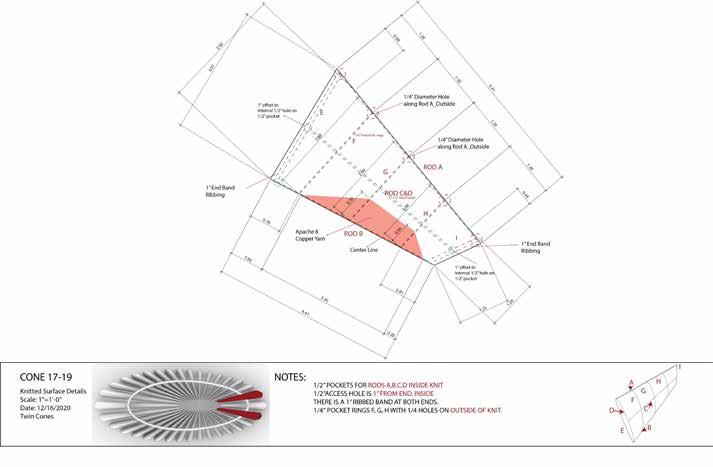


COMMUNICATION AND EFFICACY BETWEEN DIVERSE DESIGN TEAMS OF ARCHITECTS
AND ENGINEERS
AUTHORS: STEPHANIE BUNT, NATHAN BROWN
OVERVIEW
This study examines the characteristics in communication and effectiveness in diverse design teams of architecture and engineering students when working together on a conceptual design. The two professions of architecture and engineering have different design values, which can lead to more effective solutions but may also hinder convergence on a final design and create inequality in communication. This study presents a design experiment that analyzes conversational engagement and searches for instances of dominating behavior in discipline diverse teams, while determining if more engaged, egalitarian communication leads to better designs.
METHODOLOGY
Final
Stadium Roof Designs


DISCUSSION OF RESULTS
DOMINATING BEHAVIOR


From percentage of time spent talking, the engineers in each team spoke more than the architects. This characteristic aligned with the teams more effectively addressing the quantitative criteria rather than the qualitative criteria. This may be due to the inherent, numerical nature of the engineering goals, which can more easily capture the designer’s attention compared to the less distinguishable architectural goals.
Pairs of one architect and one engineer worked in an online, parametric modeling platform, which did not favor either profession, to complete a provided design task: to develop the conceptual design of a stadium roof. The task had four clear goals: two qualitative criteria that spoke to architectural values and two quantitative criteria that aligned with engineering goals. The design sessions were recorded and evaluated for when each designer spoke. The pairs also submitted a design statement that was assessed to determine how effectively the pairs addressed the design task criteria.


DIALOGUE PACE
The majority of the teams were jovial in their design dialogues, but one team (Pair 3) expressed more tension and disagreement in converging on a design. They had fewer exchanges per minute than other teams and had longer, uninterrupted instances of speaking. Notably, other effective team (Pairs 5 and 7) completed their design in less time and shared quicker, shorter exchanges. Effectiveness in design and communication between diverse teams of architects and engineers seems to relate to more numerous exchanges and positive tones in dialogue.
CONTRIBUTIONS AND FUTURE WORK
By documenting how and when student designers spoke with relationship to the design task’s objectives, along with the characteristics of their dialogue, this study considers how communication patterns impact cross-disciplinary collaboration and design efficacy. This research will continue to collect data in order to draw more complete results and compare the discussions of diverse design teams to that of similar design teams.
Using Machine Learning to Inform the Spatial Design of Energy Self-Sufficient Communities
VINA RAHIMIAN, JOSÉ DUARTE, LISA IULO
RESEARCH INTRODUCTION
Cities are complex systems that face continuous change of environmental, developmental, and political conditions. This dynamic complexity calls into question traditional urban planning and design principles, and demands new approaches that can be accomplished using new technologies, such as artificial intelligence and machine learning. This need is particularly acute when addressing energy-related issues that are affected by environmental conditions complicated by climate change. Reaching the goal of energy efficient and resilient cities requires moving past building-scale analysis to address the phenomenon at an urban scale. A strategy for reaching energy independency in urban environments has been the development of communities that guarantee the local supply and demand for clean energy, considering both network and building configurations. However, while the spatial development process requires the participation of architects and urban planners, the relationship between urban form and energy performance has not been widely explored in the design of high-performance energy communities. This may be due to the complexity associated with studying how urban form impacts energy performance and the unavailability of tools for designing and assessing energy performance at this scale.
METHODOLOGY
In this study, the use of artificial neural networks is described as a method to unravel the complex, intertwined relationship between urban form and energy demand in communities in the context of San Diego, California. Nineteen indices of urban form (Figure 1) have been measured for all zip codes in San Diego and their monthly values of energy consumption have been acquired through the county’s utility company, SDG&E. An artificial neural network has then been trained on the dataset of urban form and energy consumption values (Figure 2), resuting in a predictice model. Inference on the predictive model has been done using Shapley values showing that the most influential indices of urban form on energy consumption are related to the compactness, passivity, shading, and diversity of a community in the context of the case study (Figure 3).
The statistical results of this procedure are interpreted in terms of their architectural implications towards adding a spatial dimension to the existing technical
discourse on developing energy-independent communities. The architectural interpretation is then translated into general rules and principles for spatially designing communities in San Diego that would maximize the energy performance of their underlying solar microgrid.


FINDINGS
By spatially and architecturally interpreting the result of the predictive model, the findings below were identified as a set of rules informing the spatial design of energy independent urban settlements in the context of the case study:
• Dense and compact neighborhoods where the distance between buildings is minimal, not only increasing rates of energy demand but also due to the effect overshadowing, the potential for installing photovoltaic (PV) panels on building and land surfaces are decreased. Specially in scenarios where building facades are used for mounting PV cells, it is important to keep the south facing facade clear from any shadows from surrounding buildings in order to maximize the amount of produced solar energy.
• Larger building volumes demand more energy.
• For a fixed volume, buildings with less surfaces exposed to the environment require less energy for space heating and cooling.
• For lesser energy consumption, spaces within a building need to be approximately 12 meter (or less) in depth,
o If a space (or a building floor area) has more depth and thus is larger, shorter heights can help with reducing the energy demand of that space or building.
• More buildings or more operational units within a community result in more energy consumed by the community, which in turn means the need for more PV energy to be produced in the community.
Figure 2: Plots demonstarting the quality of the training process.
Figure 3: The magnitude hierarchy that each of the urban form features has on energy consumption in this study.
Background
This work seeks to illustrate how accurate geometries derived from point clouds can be used to assist in generating new adaptive reuse designs. Geometry and boundary conditions of a structure are often oversimplified when common adaptive reuse techniques, such as laser scanning and photogrammetry, are applied. Thus, this work develops a grammar-based methodology that supports fully actualized floorplan analysis for a historical dwelling.
The case study for this research is the Sobrado building type, an architectural typology prevalent in the historical center of Sao Luis, Brazil. A typical Sobrado, located at Rua do Giz 445 9, was identified and serves as the case study building.

Measurement
To capture the geometry of the case study building conditions, photogrammetry methods (Google Earth Pro, Autodesk Recap) were used to document the structure. From the generated point clouds, slices were taken at different altitudes to create accurate floor plans. The model was created using the extracted point clouds that were trained and transformed into data sets.
From an aerial view of the identified Sobrado building in Google Earth Pro, a video of the 3D model of the building was taken. Using free editing software, frames of the video were extracted. These extracted images were processed using Autodesk ReCap. The model was used for processing dimensions and forming a general understanding of the overall building. In addition, the original floor plan configuration is used to extract information on the interior walls.
The information was then stored and processed on the developed code. The length of the building is equal to 26.5m and the width is equal to 21m. The width of the external masonry walls is equal to 1m, and the width of the internal walls is approximately .5m.
A Grammar-Based Methodology to Support the Adaptive Reuse of Historic Buildings
The Case Study of The Sobrado Building Type
AUTHORS: D. M. S. Paulino, R. K. Napolitano, H. Ligler, K. Bak, E. Hill
Research Overview
The documentation and understanding of the original configuration of a building while maintaining its historical relevance is an important piece of the adaptive process of the historical center of Sao Luis. This project proposes a shape grammar approach to the analysis of floor plans aiming to contribute further to the adaptive reuse for the ‘Sobrado’ buildings projects.
A grammar-based approach is defined to produce a labeled plan to the original building configuration. Presently during this process, the plan is idealized as a grid domain, aiming to facilitate the rehabilitation process, in which each cell grid can be considered as a possible solution for the placement of new elements. Discretization of these cells is at the discretion of the size of walls and based upon the accuracy of floorplans used.
At the present stage of this research, labels for the main elements are defined, according to the Labels Rule Set. These rules produce a labeled plan that identify the: a) type of walls — load-bearing masonry walls (Rule 1.1), pombaline walls (Rule 1.2), and non-structural walls (Rule 1.3); b) facade elements — the main entrance (Rule 1.4) and the facade doors (Rule 1.5); and c) circulation areas — stairs and corridors (Rule 1.6).
A user-friendly interface allows the user to select spaces on the grid by drawing rectangles. The code automatically places the interior walls. Two subdivision schemas are proposed: 1) considering all the original walls; and 2) considering only the non-damaged walls. These two examples are shown to demonstrate the different possibilities of the proposed computational application. The user can run the code and select different spaces, as well as different subdivision rules. Once the user finishes selecting the spaces, the labeled floor plan for the new project is achieved.
Conclusion
A grammar-based approach is presented to generate labeled floor plans based on Shape Grammar. As such, two strategies were defined: 1) labeling rules to identify elements in the plan; and 2) subdivision rules to generate internal spaces. Rhinoscript and Python are used to develop a computational approach that automatically generates labeled floorplans for the original configuration. The approach also defines a user-friendly interface to produce various subdivision space configurations.
The methodology can be applied to other Sobrado buildings, and it allows for future integration with genetic algorithm for the optimization of new elements’ placement in a floorplan. Once the overall procedure is implemented, the authors will evaluate the different solutions accordingly to user and code requirements.


Case Study Building Facade
OVERVIEW
Recreation is essential for social, physical, and mental health and well-being (Schalock and Kiernan, 1990; Schwarzenegger et al., 2005; Gulam, 2016). Previous studies have reported an uneven distribution of recreational and open space in Delhi (Vagale, 1962; Acharya et al., 2016; Kaur, 2019). Previous research also highlights the need for studies on people’s recreational choices in the city’s recreational facilities, which lack accessibility (Acharya et al., 2016).
From the analysis of the master plan and the existing literature, we can infer that the informally-developed settlements do not have open spaces designed for recreational purposes at the neighborhood level.
The proposed initiatives by the state to improve living conditions in informallydeveloped settlements present an opportunity to seek insights into the heterogeneous resident population’s preferences for social interaction and recreation spaces within and outside the settlement.
The study findings draw attention to the challenges faced by residents in dense urban areas in pursuing recreational activities in public spaces during and before the COVID-19 pandemic.
METHODOLOGY
Using a case study, this research adopts a mixed-method approach for data collection, including photographic documentation conducted before the COVID-19 pandemic. It also includes surveys and phone interviews conducted after the onset of the pandemic.
ACKNOWLEDGEMENTS
The work presented in this poster was supported by the Department of Architecture at Penn State.
REFERENCES
Acharya, Sanghmitra S., Sucharita Sen, Milap Punia, and Sunita Reddy. 2016. Marginalization in Globalizing Delhi: Issues of Land, Livelihoods and Health. First. Springer. Gulam, Aafid. 2016. “Recreation- Need and Importance in Modern Society.” International Journal of Physiology, Nutrition and Physical Education 1 (2): 157–60. Kaur, Ramneet. 2019. “Analysis of Active Recreational Zones in Delhi.” In Metagreen Dimensions. CET Trivandarum. L. R. Vagale. 1962. “Recreational open spaces in selected cities of India.” Ekistics, Presented in Annual Town and Country Planning Seminar, Madras 14 (82): 82–84. Schalock, Robert L., and William E. Kiernan. 1990. “Recreation and Leisure from a Wellness Perspective.” In Habilitation Planning for Adults with Disabilities, edited by Robert L. Schalock and William E. Kiernan, 83–94. Disorders of Human Learning, Behavior, and Communication. New York, NY: Springer. https://doi.org/10.1007/9781-4612-3372-5_7. Schwarzenegger, Arnold, Mike Chrisman, and Ruth Coleman. 2005. “The Health and Social Benefits of Recreation.” An Element of the California Outdoor Recreation Planning Program. California: State of California Resources Agency.
DELHI’S LEISURE SPACES:
PATTERNS OF SPATIAL USE IN A MIXED-INCOME
INFORMAL SETTLEMENT
AUTHOR: SANA AHRAR ADVISER: ALEXANDRA STAUB
RESEARCH FINDINGS

IMAGE CREDIT: SANA AHRAR

IMAGE CREDIT: SANA AHRAR
By analyzing spatial use patterns within the mixed-income informal settlement pre-COVID 19, the study shows that in the absence of designed spaces for recreation and social engagements (such as neighborhood parks and community centers), the user groups use private spaces, streets, local markets, and religious spaces for informal socializing and recreation.
The study also found that middle-class residents’ criteria for selecting recreation spaces outside the neighborhoods are focused on social acceptability and social control. In comparison, physical and financial accessibility factors influence recreational space used by working-class groups residing within the same settlement.
These findings can serve to inform planners and policymakers on the need for strategies to ensure equitable access to recreational spaces at the city and district levels.
findings through field observations and surveys indicate that such sites serve as a space of interaction for women from different socio-economic classes.
Figure 2: Street edge settlement periphery as used by the working class population.
RESEARCH OVERVIEW
This research investigates how religious spaces have come to shape Turkish-German women’s sense of identity in present day Germany. It examines Turkish-Muslim women’s discursive production and cultivation of ethno-religious identities through gendered discourses produced in the Marxloh Merkez Mosque and the German public. It also explores the how these gendered discourses influence Turkish-Muslim women’s spatial behavior in the neighborhood of Marxloh and the urban space of Duisburg. This dissertation uses Judith Butler’s notion of performativity both as a theoretical and analytical lens to investigate the imaginaries, experiences, and socio-spatial behavior of mosque-going Turkish-Muslim women in Germany. The results of this effort identify heterogenous patterns of identity reproduction, belonging, and boundary-making among different generations while simultaneously using the feelings of belonging developed through Turkish-Muslim women’s lived experiences to question the dominant integration discourse that aims to forge belonging through topdown approaches.

METHODOLOGY
This study uses qualitative research methodology to understand the integration and sense of identity of Turkish-Muslim women living in Marxloh. Participant observation, expert interviews, in-depth interviews, go-along interviews, and informal conversations were used to collect the data during the nine-month ethnographic fieldwork.

ACKNOWLEDGEMENTS
The work presented in this poster was supported by the German Academic Exchange Services (DAAD), Department of Architecture at Penn State and the Political Sciences Department at the University of DuisburgEssen.
SPACES OF IDENTITY
HOW THE MARXLOH MERKEZ MOSQUE SHAPES TURKISH-GERMAN WOMEN’S BELONGING AND SENSE OF COMMUNITY
AUTHOR: IREM ÖZ
ADVISER: ALEXANDRA STAUB
RESULTS
REINFORCING THE TURKISH-ISLAMIC PARADIGM
The hybrid Turkish-German discourse that facilitated the construction of the diaspora mosque deteriorated quickly after the mosque administration was taken over by earlier generation discourses leading to: 1) women’s limited access to mosque space; and 2) spatial regimes based on gender and generational differences; men having the opportunity to specialize spaces, younger-generation women infiltrating into men’s spaces, and older-generation women only accessing the mosque space within the context of productive daily activity.


Deterioration of inclusivity in Marxloh Merkez Mosque (left) and men’s, older-generation women’s, and younger-generation women’s spaces in Marxloh Merkez Mosque (right).


BEYOND THE MOSQUE: CULTURAL PARADIGMS AND URBAN BEHAVIOR
The discourse that organizes women’s behavior in the mosque also organizes their spatial behavior in the neighborhood and urban space. While older-generation women, with the internalization of the Turkish-Muslim discourse, refrain from using the space of the “other” and limit their activities to the Turkish space of Marxloh, younger-generation women, with their reproduction of a Turkish-German discourse, feel at home in German space.


Older-generation women’s neighborhood that is defined by spaces that they use (top-left), younger-generation women’s neighborhood defined by the spaces that they ignore (bottom-left), and Turkish-Muslim women’s urban use (right).
Duisburg, Marxloh and Marxloh Merkez Mosque
MEDIA CONSTRUCTION OF THE CHESAPEAKE BAY
WATERSHED: A TALE OF THREE CITIES
Zheng Cui, J.J. De La Cruz, James Dillard, Andy High, Stephen Mainzer, Juliet Pinto, and Andy Cole
RESEARCH OVERVIEW
How do news media work to form a collective identity within and across particular regions? Through a collaboration between the Communication, Science, and Society Initiative (CSSI) and Ecology plus Design (E+D), we examine local news content to identify concepts that may lend insight toward how audiences in the Chesapeake Bay Watershed (CBW) may perceive themselves to be CBW citizens, as a first step toward better understanding collective identity formation. We pay particular attention to how these concepts vary by distance from the Bay. There appear to be meaningful divergences in the local news content that are reflective of the differing demographic and environmental characteristics.
These multi-dimensional scaling plots summarize the frequency with which keywords co-occurred in 554 newspaper articles. The more often keywords appeared together, the closer they appear in the plots. A focus on the words closest to “watershed” shows that coverage of the Bay is substantively different in each location.
FINDINGS
The news media function to influence the public and policy agendas, and are at the same time influenced by them. Media accounts that include language that creates awareness of issues, challenges, policies, or opportunities for communities within the CBW can serve to provide insight toward how communities might perceive themselves, or be unaware of their collective identity, as members of a watershed. To begin to understand how collective identity varies throughout the CBW, we embraced a broad view of sociodemographic, environmental, and media context of the CBW. There appears to be meaningful divergences in the collective identities of the three places that are reflective of their differing human and physical characteristics. Proximity to the Bay may partially explain some of these differences but as a whole, the CBW is a complex heterogeneous landscape of fragmented people and places.


Overall Watershed