13 minute read
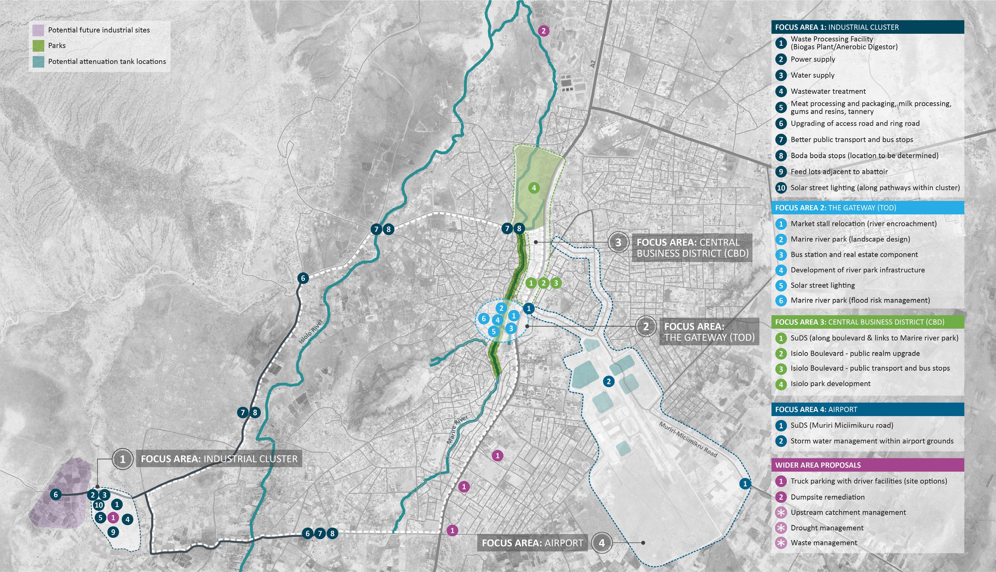
Focus Area 2: The Gateway (TOD
ECONOMIC DEVELOPMENT PLAN 52
FOCUS AREA 2: THE GATEWAY - TRANSIT ORIENTATED DEVELOPMENT (TOD)
“The Gateway” is a mixed-use project formally marking and celebrating the arrival to Isiolo.
Set in a strategic location of town, it sits beside the new Market building (under construction) and opposite the new Stadia, which is also under development. This zone is known for its exposure to seasonal and repeated floods. The Municipality has allocated, and is keen to retain the site, for a new bus station albeit this being exposed to flood risks.
As such, a robust flood management strategy is necessary to mitigate and contain the risks associated with the area, whilst releasing enhanced development potential across the site.
Figure 21 - Development Framework plan showing Focus Area 2 - The Gateway (TOD)
53 ISIOLO URBAN ECONOMIC PLAN
Focus Area 2: Sequencing The projects have been numbered in order of their preferred and optimal sequencing as follows:
1. Market stalls relocation - as noted in the introduction this area is subject to seasonal flooding due to its low-lying location and adjacency to the Marire River channel. It is proposed that these areas be cleared of market stall structures to permit a comprehensive earthworks and storm water drainage intervention to be undertaken to create protective berms and river embankments. This will protect existing properties and create additional land areas that will become available for the proposed mixed use (TOD) and public realm improvements. 2. Marire River Park - the de-cluttering of the river’s riparian areas from informal structures and dumping will enhance the storm water carrying capacity of the river channel and permit public realm facilities to be developed such as pathways, seating areas and tree planting. This will form the southern start of the Marire River Park. 3. Bus station and real estate development - following site clearing, earthworks and stormwater management infrastructure the site is ready for development of the extended bus station and associated plot preparation for private investment initiatives. This will include the development of public plazas and concourses linking the various uses within the site and to the new market building. 4. Development of River Park Infrastructure - the proposed public realm improvements will be extended to the north along the river bank to create a green corridor along the river which will eventually link to the proposed Isiolo Bio-Park to the north of the CBD area.
5. Solar street lighting - will be installed in all public areas including along the proposed river park footpaths and seating areas. 6. Marire River Park flood risk management - the proposed storm water infrastructure will be continued northwards along the river channel to improve water flow and provide remediation measures as appropriate. This will include removing all structures that are currently encroaching the riparian area of the river.
ECONOMIC DEVELOPMENT PLAN 54
THE GATEWAY (TOD) The Gateway 1 2 3 4
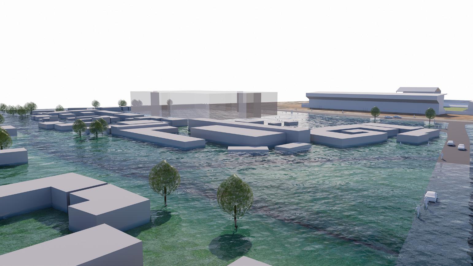
“The Gateway” is composed of a variety of uses and stems from the need to transform the current bus station. The components of the project are: Transport (Bus Terminus) a functional, semi-covered and clean bus terminus; Real Estate (RE) mixed use buildings accommodating potentially retail at ground floor and commercial/residential/hospitality uses above*; Public Realm (PR) a series of small and varied plazas linked up by pedestrian paths that interface with both the Marire River Park, the real estate components and the newly built market. A possible scenario includes the real estate component articulated in two buildings growing from 7 to 13 storeys southward sitting on a raised podium (retail and parking). In this scenario, “The Gateway” acts as a “pinnacle”, a landmark, visible when arriving in town. Good quality public realm acts as glue between the new market building, the bus station zone, the river embankment/linear park (part of other proposals) and the new buildings. The exposure to flood is addressed by the decluttering of the encroachments into the riparian zone and expansion of the natural space this is to be part of a future “Marire River Park” that acts both as public space and natural storm water container when the river swells. The overall proposal (Bus + RE + PR) is to be sitting on a man-made plateau that will protect the scheme from projected flood levels and would be used as a below grade parking area. A part embankment / part berm-like natural barrier completes the series of elements that are to protect the new market building to the north of the site. The increase in space for the river to flow freely and, potentially, be contained during intense rainfall is part of a series of nature-based, climate resilient solutions that are aimed at reducing/containing the flooding of the CBD area and the threat to life. The scheme will revitalise this area of the Town and offer significant private sector investment opportunities along with an enhanced experience to bus and market users. At the same time, it seeks to address localised flood issues and maximise the ecological value of the Marire River.
Sub-Components Estimated Cost Impacts (Benefits) Delivery Mechanisms
› Masterplan to be developed for the
TOD outlining low and high-cost options and providing solutions to existing problems in the area (includes transport, public realm & real estate) › Design of Marire River
Park › TOD CAPEX
KSh 2.4 million › Landscape regeneration
KSh 95,200k › Dedicated, functional, open and clean bus terminus › Enhances the local economy with modern amenities › Provides a positive image of the Town and adds value to sense of place › Opportunity to enhance green links and pedestrian access › Enables potential private investment initiatives › CBD storm water and flood management › Kenya Urban Roads
Authority (KURA) for road improvements › Private investment › Public realm & utilities by Municipality › Stakeholder and community engagement › Following completion: › Revenue from provision of services, business licencing › Revenue from leasing / rentals › Revenue from additional Boda boda stations
Challenges Data Gaps Time Frame Phasing Project Priority
› May require some land acquisition › Existing buildings and public realm will need to be altered › Relocation of market stalls › Construction likely to interrupt current functioning of market and bus station › Funding › Pre-feasibility and feasibility studies › Site topocadastral survey is needed › Land ownership register › Medium to long term › Phase 1 -
Infrastructure for bus terminus, including flood management › Phase 2 - Real estate and public realm, along with river park development › Bus Terminus by operating authority, public roads by
Municipality › Private areas by operator / leaseholder › Public areas by
Municipality (ie. cleaning, policing)
Operations & Maintenance
* Preferred components are to be confirmed following surveys and technical, market and financial / economic viability studies.
55 ISIOLO URBAN ECONOMIC PLAN
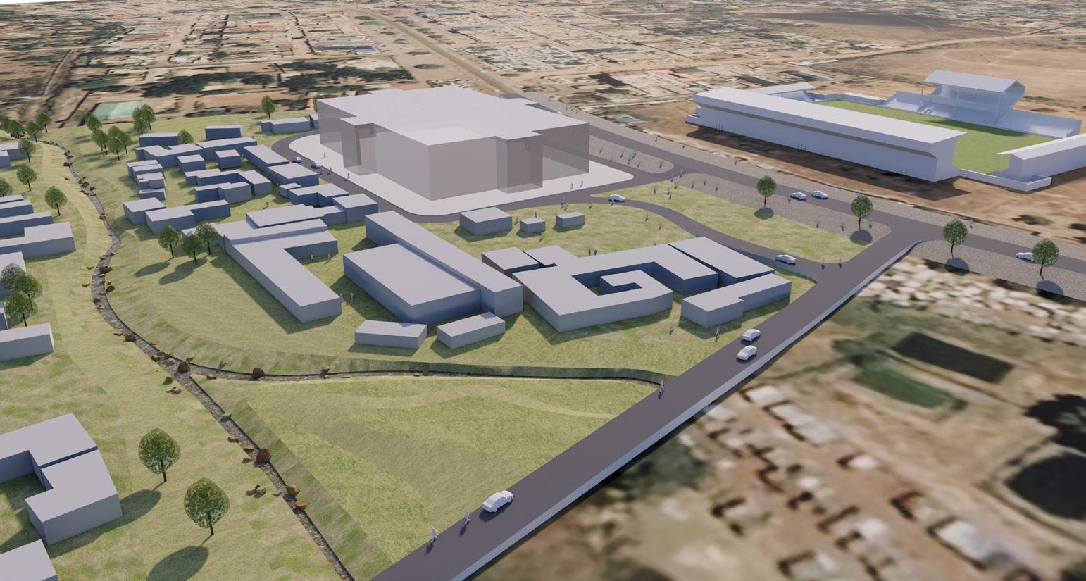
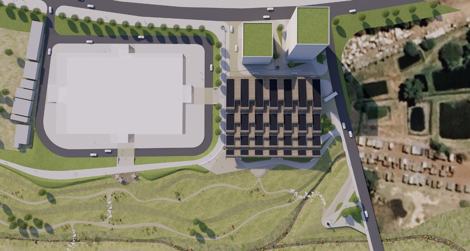
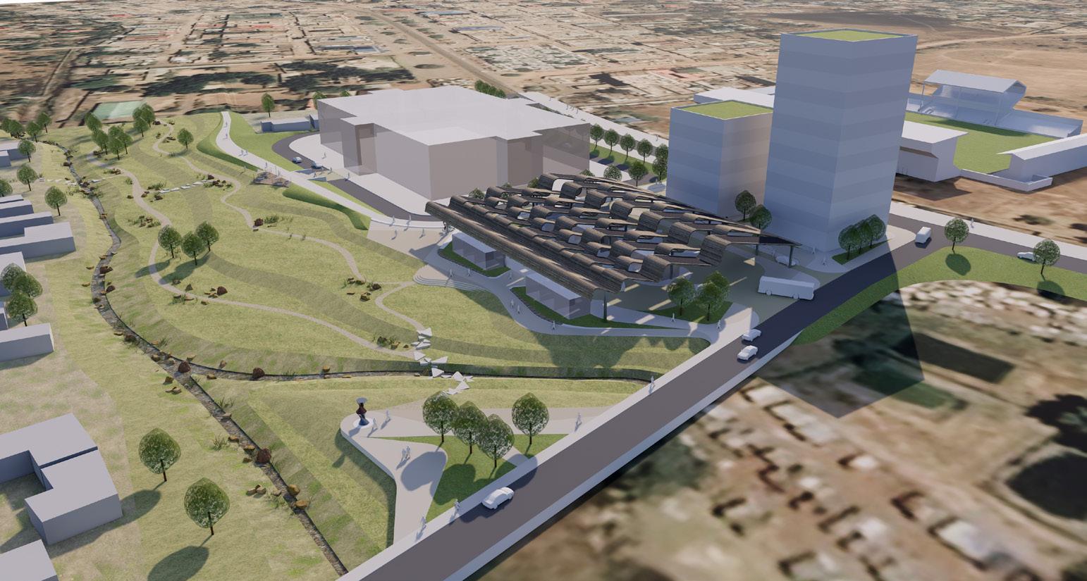
As existing plan view of the proposed market under construction and existing market stalls
As existing high level view showing the Marire river bed and market stalls in the flood plain As proposed plan view showing the new bus terminus and mixed use structure
As proposed high level view showing the new bus terminus and TOD away from the flood plain and enhanced public realm on Marire River Park bank

ECONOMIC DEVELOPMENT PLAN 56
Sequence of images showing the rising flood levels in the Marire river that could cause catastrophic damage to buildings nearby the flood plain if appropriate measure are not undertaken
1 2

3 4


57 ISIOLO URBAN ECONOMIC PLAN
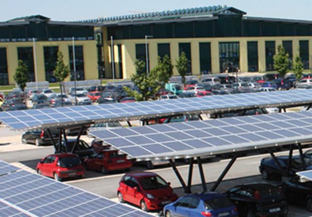
THE GATEWAY (TOD) Solar Canopies for Market and Bus Station 5
Outcome
› Provision of solar PV canopies over the new market area and bus station
› Improved life for market traders, customers and bus travellers due to improved ability to undertake more advanced economic activity, and improved safety
Sub-Components
› Detailed study of target recipients to determine current/ potential demand and ability to pay › Financial modelling › Community/ stakeholder engagement plan › Initial technical design, economic, social and environmental analysis › Development of procurement and deployment/ implementation plan › Operation plan (including revenue collection, maintenance etc.) › Benchmark:
US$ 1,600 per kW › Actual:
Bus station (265kW)
US$370,000 › Market (100kW)
US$160,000 › Funding (eqpt, installation, maintenance): › Part IFI, part public funded › Increase in business activities › Reduced carbon emissions › More grid power available for other uses › Improved health, safety and security (through provision of under canopy lighting) › Coordination with
Isiolo County
Government and other interested parties › Partnering with local / regional solution providers and equipment specialists such to determine appropriate design and technology solutions › Maintenance - capacity building programme to ensure continued operation of systems › Maintenance - responsibility of
Municipal govt
Estimated Cost Impacts (Benefits) Delivery Mechanisms Challenges
› Perceived high cost of solar canopies › Funding Data Gaps
› Detailed information on market activities Time Frame
› Short to mid-term
Case Study: SolarAfrica is a solar energy solutions provider that offers tailored solutions for businesses, residential energy users and large commercial and industrial sites in Africa. They are based in South Africa, Kenya and Mauritius. They fund and own the solar system, but commit to provide the users with reliable energy that is cheaper than the utility supply, and take care of maintenance. The user doesn’t expend any capital, but enters into a long term contract with SolarAfrica utilising one of two options; paying only for the energy they use, or paying a fixed monthly fee where they can use all of the energy that the facility generates. SolarAfrica completed the installation of an 858kW solar PV system at Garden City Mall in Nairobi, Kenya. The system covers 32 acres of the mall car park, and provides electricity to the nearby mall and additionally provides shading to cars during the daytime, as well as lighting (underneath the canopy) during the evening/ night.
ECONOMIC DEVELOPMENT PLAN 58
Poor storm drainage system in Isiolo Town. Drainage system such as drainage channels, culverts and side ditches along roads have not been developed to function as a network in Isiolo Town.18 Therefore, after rainfall event, the rain water stays on the surface causing the downtown to flood. The depth of flood water can reach up to 500mm.19 Existing drainage features needs to be maintained (example: litter picking) to ensure the system is providing full capacity to convey water. SuDS features are required to manage rainwater runoff coming from the east of Forest Road affecting the market area to west of the road. Every time there is a heavy rainfall, the associated overland flows flood the market stalls impacting on the income of the sellers.20 The following proposals can improve the surface water drainage system: › The existing road currently has only one channel. It is proposed to provide two larger channels on both side of the road to intercept flows and to create a continuous conveyance of rain water along the road. Outfalls are to be located at the Isiolo Park and (if feasible) storage tanks located at the Sewage treatment works to the north of the park.
The water can be treated and recycled/reused in process plants or for the irrigation of green spaces on site or crops in the local vicinity; › To integrate SuDS features in the new market area and new stadium, for example: local vegetated bioretention areas planted with drought resistant plants and trees. These features are visually attractive and may include seating, and efficient to manage local ponding of water.
18, 19 & 20 Isiolo Flood Management Plan Sub-Components Estimated Cost Impacts (Benefits)
Swales and conveyance channels
Bioretention areas planted with drought resistant plants
Tree pits 1,341,000 - 2,139,000 KSh. Costs varies depending on dimensions of swale TBC following detailed design.
TBC - following concept and detailed design process.
35,360 KSh based on a tree (every 6m) along 2 No. swale. Prices do not include: surface treatment (permeable surface and non compacted material) example: Organic mulch, loose aggregate, Sand -based substrates (used in clay soils and high water table areas to add capcity for water and nutrient retention). Manage Surface Water runoff by enhancing the drainage network and providing multiple mechanisms for the water to dissipate (e.g. infiltration, evapotranspiration). Provides a positive image of the Town, creates a Centrepoint and sense of place for the Town, encouraging more visitors. Opportunity to enhance green links and pedestrian access. Has the potential to regenerate the surrounding area and increase value of the local economy. Reduce pollutant concentrations in stormwater by acting as a buffer and as a result, enhance the quality of the receiving water body. Provides habitats for wildlife in urban area and opportunities for biodiversity enhancement. It encourages the natural groundwater recharge (where appropriate) to minimise the impacts on aquifers and river baseflows in the receiving catchment. Delivery Mechanisms
It is likely that this initiative will require both public and private interventions to enable changes to be undertaken. Process to be led by the Municipality with coordination through local business groups, property owners and vendors.
Opportunity for the Municipality to source funds through the World Bank KUSP programme.
Challenges
› Retrofitting SuDS elements require appropriate planning collaboration between residents and councils to implement and maintain the system. › Long-term operability (i.e. maintenance requirements) › Funding › No knowledge of current drainage system › Data of runoff volumes and flow capacity requirements › Site investigation such as infiltration testing and drainage network and topographical survey will be required Short term
Data Gaps Time Frame
59 ISIOLO URBAN ECONOMIC PLAN
Case Studies: Zhenjiang City, China21
This project implemented stormwater management retrofits for 22km2 of watersheds within the City of Zhenjiang. City of Zhenjiang is an old-high density urban residential and business area. The city suffered from extreme flooding every year and water quality deterioration of the receiving water bodies caused by combined sewers overflow and storm water runoff. The “Sponge Cities” concept was implemented in the city and aimed to provide urban areas that is ready to meet climate change challenges such as flooding, water pollution and droughts by integrating grey and green infrastructure to reduce surface water runoff, and reduce pollution by providing water treatment at the source. Discussions between the different stakeholders and community engagements workshops was part of the design process. The design aimed at: › Convey 30-year storm event; › Improve Water Quality of Receiving Water; › Treat 75% of annual runoff volume; › Reduce annual Total Suspended Solids (TSS) load by 60%.

The results were successful, it was noticed that the new system provided 72% reduction of surface water runoff for the 1 year 2 hour event. And 47.5% runoff volume reduction for the 30 year 24 hour event.
21 https://www.wasla.org/assets/Session_4_Redrawing_Grey_Cities_to_Climate_Resilient_Sponge_Cities.pdf Additional Case Studies: Swales


Swale used as a conveyance channel in the center of the road Continuous swale along the side of the road, Source: EPA Office of Water

Swale with stone check dams to protect erosion Swale with rocky check dams - Northgate Seattle

Source for Swales: https://wiki.sustainabletechnologies.ca/wiki/Check_dams


