2 minute read
Caltrans Taps VR Startup to Assess Hwy 1 by Elkhorn

COMMUNITY NEWS Caltrans Taps VR Startup to Assess Hwy 1 by Elkhorn
Advertisement
For the first time, Caltrans is using virtual reality to address sea level rise and evaluate mitigation options for a major highway in the state — Highway 1 along Elkhorn Slough.
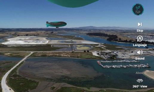
“Not taking action is not an option,” said Caltrans Director Toks Omishakin. “Due to sea level rise, we know this section of Highway 1 near Moss Landing and other A screen shot of Virtual Planet’s app “Sea Level Rise Explorer: Elkhorn Slough”, available in the Apple and Google app stores. coastal routes are vulnerable, so Caltrans experience of watching the water lev- el has made climate action a primary goal. rise, as well as seeing the measures we can We are making our state transportation take now to make the transportation corsystem more resilient and sustainable.” ridor more resilient and a benefit to nature
The department relocated Highway in the Monterey Bay.” 1 inland near Hearst Castle in 2017 after With only 10% of coastal wetlands coastal erosion threatened its viability. remaining and half of that remaining area
The “Sea Level Rise Explorer: Elkhorn vulnerable to loss from sea level rise, CaliSlough” experience was developed by fornia’s goal is to protect 30% of its land Virtual Planet Technologies, a startup in and water ecosystem targets by 2030. Santa Cruz. An in-depth analysis published last
“As coastal communities worldwide year by the Association of Monterey Bay contend with sea level rise and coastal Area of Governments, the Central Coast erosion, Virtual Planet is leveraging the Highway 1 Climate Resiliency Study, demlatest technology and pairing it with onstrated a new approach to rebuild the creative storytelling to help these com- highway to benefit commuters and nature. munities better understand the imminent The study highlighted the need to impacts of climate change and visualize act quickly to implement solutions by practical solutions,” said Juliano Calil, 2050 to minimize losses to transportation Virtual Planet Technologies’ co-founder and critical habitats. The effort to inteand chief scientist, who earned his doc- grate transportation and natural resource torate at UC Santa Cruz. planning not only tackles risks posed
An eight-mile section of Highway to both due to climate change but also 1 and five miles of railway in Elkhorn explores rebuilding the highway and Slough, home to extraordinary biological railway to benefit commuters and nature. diversity, is projected to experience regular “Not only do we believe this process storm and tidal flooding by 2030. will lead to better outcomes for the Mon-
The railway east of Highway 1 already terey Bay, we think this unique approach experiences flooding at extreme high tides. to planning, leveraging available tools The marsh area, the third largest in the and working in partnership with the state state, is especially vulnerable, with about and environmental groups will serve 85% projected to be inundated with 5 feet as a model for planning throughout the of sea level rise. state,” said Heather Adamson, director of
“The impacts of sea level rise are truly planning at AMBAG. hard to visualize,” said Alyssa Mann, Caltrans recently completed climate coastal project director at The Nature Con- change vulnerability assessments for all 12 servancy. “Even though we know what is districts, including the Central Coast. likely to happen, numbers on a spreadsheet “Elkhorn App” page 13and 2D maps are no match for the visceral


