Integrated Transport Strategy


APRIL 2022

Contents 1 Transport Vision for the Town of Victoria Park ....................................... 9 1.1 Vision ........................................................................ 9 2 Implementation ............................... 18 3 Strategic Context ............................. 31 3.1 Role in the planning framework 32 3.2 Roles and responsibilities ........................................ 34 3.3 Integrated Transport Strategy development ......... 37 4 About the Town of Victoria Park in 2021 ............................................... 41 4.1 The People ............................................................... 41 4.2 The Places 44 4.3 The existing Transport Network .............................. 47 4.4 Existing Movement & Place Assessment ................. 63 4.5 User Mindset Assessment 65 5 The Future of the Town of Victoria Park ......................................71 5.1 Introduction ............................................................. 78 5.2 Future Trends 5.3 Future Movement & Place Assessment ................... 79 5.4 Challenges and Opportunities 83 2 | TOWN OF VICTORIA PARK INTEGRATED TRANSPORT STRATEGY
Acknowledgement of Country
Many of the transport routes we use today – including rail lines, roads and water crossings follow the traditional song lines, trade routes and ceremonial paths that Australia’s First Nations People traversed for tens of thousands of years.
In preparing this Strategy, the Town of Victoria Park acknowledges this heritage, as well as the Whadjuk elders past and present who remain traditional custodians of the land that includes the Town of Victoria Park.
Lizard and Eggs (1997) by Beverley Pickett (Source: Town of Victoria Park Reflect Reconciliation Action Plan).

4 | TOWN OF VICTORIA
PARK INTEGRATED TRANSPORT STRATEGY
Executive Summary
The Town of Victoria Park (the Town) is a successful, vibrant and diverse inner-city local government located immediately south-east of the Perth Central Business District (CBD). The Town’s continued success is reliant on a sustainable, accessible and integrated transport network which connects people to places. This Integrated Transport Strategy sets the strategic direction for managing the Town’s transport network over the next 10 years and identifies a range of mobility focussed initiatives that will enable the Town to continue prospering as a vibrant inner-city community.
Located within the Central Sub-Region of the Perth and Peel region, the Town is required to accommodate an additional 18,000 dwellings to meet the State Government’s 2050 infill target. This will bring an additional 45,510 residents to the Town, increasing the total population to approximately 77,230. Most of this growth will be achieved at key strategic activity centres previously identified through community engagement and precinct planning areas. This significant change necessitates the development of a strategy to cater for the current and future transport needs of residents, visitors, businesses, as well as those who pass through the Town.
At present, most of the Town’s residents access their place of work via private vehicle, with 74% opting to drive / travel by car (in comparison to 85% in the Greater Perth region) according to the 2016 ABS census data. The data also reveals that public transport usage by the Town’s residents sits at 12% for bus and 5% for train, while walking made up 4% and cycling made up 3%. The remaining 2% accounts for residents travelling to work via motorbike / scooter and the categorisation of ‘other’. This is compared to 5% for bus, 3% for walking and 1% for cycling to work for residents in the Greater Perth region.
There is an opportunity to shift these travel patterns, including building on the relatively high use of bus and train, to attract more trips to the public transport network. The State Government’s Inner Victoria Park-Canning Level Crossing Removal Project will see the removal of existing level crossings and the rebuilding of the Carlisle and Oats Street Stations. This significant investment will also entail the enhancement of each station precinct and improve connectivity to the Town’s surrounding transport network.
Further, there are a number of key destinations and local centres within walking or cycling distance of residential areas throughout the Town. Of note, the Albany Highway Activity Centre corridor forms a town centre spine running from the Causeway to Welshpool Road. As such, the Town is well placed to encourage transition from car-based travel to active modes, which has the benefit of fostering more vibrant and lively streets and promoting greater footfall through local businesses created through people travelling on foot and bicycles generally having greater exposure to, and are better immersed in, and engaged with the street environment, in comparison to those passing through by car. The adoption of increased active modes in the Town also allows for improved passive surveillance, healthier communities and positive environmental outcomes.
The emergence of micro-mobility devices, in conjunction with technological advances in transport, such as e-bikes and e-scooters, also need to be considered in how the Town designs and manages its transport network into the future. These two areas present further opportunity to better connect residents to the Town’s diverse and unique service offerings as well as the wider Perth Metropolitan transport network, by providing more choice in the way residents move around.
The Town recognises that a quality transport system for the whole community requires close and continued engagement with key partner organisations including the State Government and local user groups. This Strategy identifies opportunities for the Town to collaborate with key partners to achieve the vision of the Town’s transport network.
This Strategy was developed using a place-based approach which aims to understand and evaluate how transport can better support the desired place outcomes of the Town. The place-based approach includes a Movement and Place assessment of the Town’s places and streets for existing and future conditions. The Movement and Place assessment reflects how people access and interact with the Town’s places now and in the future, and highlights that for the Town to grow sustainably the function of streets may change.
In addition to the Movement and Place assessment, the development of this Strategy has utilised a user mindset exercise in order to evaluate the diverse needs and wants of the Town’s existing and future transport users. This involved the development of eight user mindsets which reflect a sample of the Town’s population to test the Strategy’s ability to cater for different customer needs and highlight any gaps in the existing transport network.
This Strategy represents the Town of Victoria Park’s commitment to addressing current and future transport opportunities and challenges, creating a more integrated transport system that complements surrounding land uses. Further, this Strategy seeks to contribute to achieving the
Town’s vision as A dynamic place for everyone that enables safe, enjoyable and convenient journeys to, from or within the Town, for all modes of transport.
Our Vision
To ensure alignment of this Strategy and the Town’s broader planning framework, the Town of Victoria Park have developed a vision for the transport network over the next 10 years which is:
To provide an integrated, accessible and sustainable transport network which connects people to places and supports the Town as a liveable inner-city community.
There are three themes underpinning this vision which are:
• A Healthy Community;
• An Accessible Town; and
• A Liveable Town.
The three themes are supported by 17 objectives which have been used to identify and prioritise a series of initiatives.
6 | TOWN OF VICTORIA PARK INTEGRATED TRANSPORT STRATEGY
Key Terms
KEY TERM DESCRIPTION
Mode / Multimodal
Mode Share
‘Mode’ refers to the various transport options that people use to travel from one place to another. Examples include walking, cycling, catching the bus or train, as well as driving a car. Some people may engage in a combination of travel methods as part of their journey, which is referred to as a ‘multi–modal’ trip.
‘Mode share’ is used to describe the proportion of people using each mode of transport for a certain trip type, or to a specific destination, normally expressed as a percentage.
1 Transport Vision for the Town of Victoria Park
1.1 Vision
Mode
Shift
Active Transport
Travel Demand Management
‘Mode shift’ is used to describe changes in travel patterns, in terms of the mode of transport used by people, over a period of time.
‘Active transport’ refers to non-motorised transport modes, including walking and cycling.
‘Travel demand management’ is the concept of applying strategies or policies with the aim of incentivising or disincentivising certain travel behaviours, with the intent of ‘mode shift’. This may include encouraging people to consider alternative modes of transport for certain trips or redistributing travel demand at particular times of the day.
This Strategy seeks to contribute to achieving the Town’s vision as A dynamic place for everyone. To ensure alignment of this Strategy and the Town’s broader planning framework, the Town of Victoria Park have developed a vision for the transport network over the next 10 years which is:
To provide an integrated, accessible and sustainable transport network which connects people to places and supports the Town as a liveable inner-city community.
The vision, themes and objectives are outlined in Figure 1.1.
End of Trip Facilities
‘End of trip facilities’ is a term used to describe infrastructure provisions in buildings or communal locations (e.g. workplaces, schools, community hubs) that support and facilitate the use of active transport modes, such as walking and cycling. Examples of ‘end of trip facilities’ include bicycle parking, showers, change rooms and lockers.
Emerging Technologies
Micro-mobility
‘Emerging technologies’ refers to new technology that is currently in the process of being developed or is expected to be developed / refined over the next 5 10 years. Transport examples relevant to this Strategy include electric vehicles, driverless vehicles and trackless trams.
‘Micro-mobility’ is a term used to describe various small, lightweight vehicles that are used by an individual to travel from one place to another. ‘Micromobility’ devices can be motorised, such as electric bikes, electric scooters and electric skateboards, typically operating at speeds of 25km/hr or less. They also include traditional “human powered” wheeled recreational devices including bicycles, scooters, and skateboards see ‘Active Transport’.
Figure 1.1: Vision, Themes and Objectives Vision To provide an integrated, accessible and sustainable transport network which connects people to places and supports the Town as a liveable inner-city community. A Healthy Community Objectives HC.1 Support Vibrant People Focused Local Centres HC.2 Resilient & Prosperous Local Economy HC.3 Road Safety for All Users HC.4 Encourage Mode Shift HC.5 A greener Town of Victoria Park Objectives A.1 Support a 15 minute Town A.2 Connecting people to places A.3 A balanced network A.4 Cycling infrastructure for all ages and abilities Objectives L.1 Inclusive for all L.2 Considered approach to new technology L.3 Sustainable modes are the first choice L.4 Work with partners and community to acheive transport outcomes An Accessible Town Initiatives A Liveable Town 8 | TOWN OF VICTORIA PARK INTEGRATED TRANSPORT STRATEGY
1.2 Themes
Three overarching themes underpin the vision which are: A Healthy Community, An Accessible Town and A Liveable Town. Each theme underpins the vision and represents the transport networks role and how transport will contribute to achieving the Town’s vision of A dynamic place for everyone. Each theme is supported by a number of objectives which provide the basis for the identified initiatives. The identified themes and objectives have been developed in collaboration with various departments within the Town and are consistent and complementary with the Town’s informing Strategies. The following section provides an overview of each theme and its supporting objectives including what they seek to achieve.

10 | TOWN OF VICTORIA
TRANSPORT STRATEGY
PARK INTEGRATED
1.2.1 A Healthy Community
The design and management of a community’s transport network plays a key role in fostering healthier populations and more sustainable environments. This Strategy aims to provide the residents of the Town with choice when it comes to transport. By designing streets that better facilitate walking, cycling and ease of access to public transport, the Town is striving to empower residents to choose more sustainable transport modes. Fewer cars on the road will result in health benefits, not only for those that choose to make the switch, but it also means reducing vehiclerelated emissions and reduced road trauma.
HC.1 - Support Vibrant People Focussed Local Centres
Vibrant local centres are underpinned by people focused streets. People focused streets are welcoming, safe and provide opportunities to dwell. To achieve this, it is important that the streets supporting local centres are designed for people. This Strategy aims to enhance the Town’s local centres by making them more people friendly. To achieve this, the transport network must prioritise pedestrians through the provision of wider footpaths, shared spaces, prioritisation at intersections and the provision of shelter and shading.
HC.2 - Resilient and Prosperous Local Economy
The transport network plays an important role in the resilience and prosperity of the Town’s local economy. Multi-modal transport accessibility to the Town’s local businesses is vital in facilitating equitable access for the whole community. The community seek convenient and safe access to key destinations and the assurance there is a safe, nearby location to park their bike, car or other mode of transport. In addition to this, there is a direct link between local economic prosperity and the safety and convenience of walking. The presence of a sustainable, safe and integrated transport network which connects people to the Town’s key destinations also attracts additional businesses to the Town which adds to the diversity of local business and stimulates the local economy.
HC.3 - Road Safety for All Users
This Strategy aims to assist in achieving WA’s Driving Change – Road Safety Strategy for Western Australia 2020 2030. Safety of the transport network was a key theme in the community consultation outcomes, with respondents requesting safer road, cycling and public transport networks. Community engagement undertaken for the Town’s Joint Bike Plan found the lack of cycling infrastructure and the presence of high traffic volumes and speeds was a key concern to cycling within the Town. This Strategy aims to improve road safety for all road users through a number of initiatives aimed at improving the provision of a safe, integrated cycling network, prioritisation of pedestrians at key locations and improvements at key safety hotspots for vehicles.
HC.4 - Encourage Mode Shift
Currently the most common mode of transport for the Town’s community is via private vehicle. According to the Town’s draft Climate Emergency Plan, transport emissions account for 34% of the average Australian family’s greenhouse gas emissions. A mode shift away from private vehicles will not only aid in achieving the objectives of the Climate Emergency Plan but also deliver social, economic and health benefits to the Town. In addition to a sustainable mode shift, the Town will aim to provide people more transport options, reducing reliance on private vehicles.
HC.5 - A Greener Town of Victoria Park
The transport network plays a vital role in promoting a greener Town. A greener Town will encourage a greater uptake of walking and cycling and foster more enjoyable journeys. This will in turn encourage a greater mode shift which will contribute to the reduction in noise and air pollution. This objective is supported by a range of initiatives which aim to create improved streetscapes within the Town, making walking more enjoyable and aiding in achieving the objectives in the Town’s Urban Forest Strategy.

12 | TOWN OF VICTORIA PARK INTEGRATED TRANSPORT STRATEGY
1.2.2 An Accessible Town
A transport network that is designed to support the safe and efficient movement of people is vital. While there is emphasis on supporting a mode shift from private vehicle usage to more sustainable modes, including walking, cycling and public transport, the Town recognises that for some residents, a private vehicle is essential to how they access the Town’s services, with no other choice. By supporting development of a 15-minute town, this Strategy aims to better connect the Town’s residents with its services irrespective of mode.
A.1 - Support a 15-Minute Town
Through effective design and management of the transport network, the Town is seeking to connect its residents to key services, in alignment with the guiding principle of ‘a 15-minute town’. This recognises that the Town has a lot to offer within its immediate locality. By actively promoting and making it easy for residents to undertake localised trips, this has the benefit of supporting the Town’s local economy.

A.2 - Connecting People to Places
A good transport network is designed to connect people to key destinations. In the case of the Town, its location as a vibrant, inner city Local Government area results in various places of interest, both immediately within the localised catchment as well the wider surrounding area. The transport network plays an important role in facilitating access to, and enjoyment of, these key services and places of interest. Accordingly, this Strategy aims to facilitate improved connectivity within and throughout the Town for all modes.
A.3 A Balanced Network
The Town recognises that not all people have equal access to all modes of transport. Through this Strategy, the Town is seeking to encourage active and public transport modes for people and trips where it is a genuine option, without excluding those where it is not. Through applying a Movement and Place lens, the Town has taken a proactive approach in defining the existing and desired form and function of its streets. This approach recognises that not all modes can have equal priority on every street due to space constraints. However, the approach applies careful consideration to the movement and place function of each individual street, so that it can be designed and managed accordingly.
A.4 - Cycling Infrastructure for All Ages and Abilities
The benefits of cycling as a mode of transport are widely cited, however, when it comes to promoting greater uptake, a number of common themes can be observed when considering the barriers to cycling. Broadly, these issues include safety, connectivity and quality. Thus, in order to propel any real shift in mode share from car-based travel to active modes, the transport network has a critical role in supporting this change. This Strategy aims to encourage implementation of cycling infrastructure and supporting initiatives which enables people of all ages and abilities to feel comfortable cycling in and around the Town.
14 | TOWN OF VICTORIA PARK INTEGRATED TRANSPORT STRATEGY
1.2.3 A Liveable Town
The Town is a vibrant place with several key attractors and diverse service offerings. This includes major education and employment hubs such as Curtin University and the South Metropolitan College of TAFE, as well as retail, food, beverage and entertainment venues. As such, a good transport network is necessary to connect residents to these destinations so they can be enjoyed and accessed by all.
L.1 - Inclusive for All
The diversity of the Town’s places, in conjunction with the diversity of the Town’s residents, means that each trip purpose will be unique, be it for work, school, exercising, shopping, socialising or other. So that all residents can get maximum enjoyment from these places, this Strategy aims to support the delivery of a safe transport network which is highly accessible, and therefore, inclusive for all.

L.2 Considered Approach to New Technology
New technology presents an opportunity to enhance the existing transport network. New technology such as micro-mobility modes are becoming increasingly attractive as alternative transport modes as they provide a light weight, fast, and cost-effective way to undertake short trips. In addition to this, new micro-mobility modes provide good alternatives for first and last-mile freight deliveries. However, without a considered approach to new transport technologies, alternative transport modes such as walking, and cycling may be compromised. Other new technologies such as autonomous vehicles and shared micro mobility transport schemes may become possible in the near future. This objective aims to ensure the Town has a considered approach to new technology to ensure the potential benefits are maximised and possible drawbacks are managed.
L.3 Sustainable Modes are the First Choice
Effecting a mode shift away from predominantly car-based travel to sustainable modes requires careful and considerate design of the transport network. This Strategy aims to support streets that are user-focused, acknowledging that people will be drawn to travel options where they feel safe and are considered convenient. As an example, this could include initiatives such as installing dedicated, high quality infrastructure for pedestrians and cyclists along primary routes, designing streets to slow vehicles down, planting trees to provide shade and enhance the overall urban environment. It is through such changes; the Town can work towards encouraging sustainable modes as the first choice for residents.
L.4 - Work with Partners and Community to Achieve Transport Outcomes
The Town is committed to achieving the vision of this Strategy; however, we are required to work in close collaboration with key partners and the community to do so. With various components of the transport network owned, managed and operated by other agencies the Town acknowledges the importance of working in close collaboration to achieve the best outcomes. The community play a vital role in achieving the transport outcomes of this Strategy. The Town is committed to working with the community to ensure the transport network reflects community needs and preferences.
16 | TOWN OF VICTORIA PARK INTEGRATED TRANSPORT STRATEGY
Implementation
This section outlines the key sub-programs, that combined form the overall Integrated Transport Strategy program and deliver on the objectives under each of the three themes. The role the initiatives within the sub-programs have in contributing to the three themes and supporting objectives has been assessed on a three-point scale (low, medium and high) which is displayed in the table.
The sub-programs and their initiatives have been identified through consideration of the various analysis, investigation and community engagement undertaken in developing this Strategy, as well as the Town’s existing planning framework.
INITIATIVE REASONING Pedestrian Infrastructure Sub-Program
High quality pedestrian environments are pivotal to increasing travel by active and sustainable modes of transport. Therefore, this initiative will play a key role in achieving the three themes of this Strategy and is considered a priority for implementation.
Included in this program is the development and implementation of a Town Wide Wayfinding Strategy which is considered a high priority for the Town. Achieving all three themes of this Strategy, the implementation of a Wayfinding Strategy will improve the legibility, safety and ease of pedestrian and cyclist navigation of the Town’s network and will in turn increase the attractiveness of these modes of transport.
Table 1: Integrated Transport Strategy Program (broken into sub-programs) and supporting existing programs.
INITIATIVE REASONING
Skinny Streets Sub-Program
The Skinny Streets program involves narrowing certain local streets to encourage lower vehicle speeds. By reducing their hostility, the town hopes to encourage more walking and cycling on local streets, fostering a healthier and cohesive community. Based on the feedback received during the community consultation process, this program is considered a priority initiative for the Town.
Streetscape Improvement Plan Sub-Program
Implementation of the Town’s Streetscape Improvement Program will deliver a more inviting, healthy, accessible and liveable Town and is fundamental in achieving the vision of this Strategy. The Streetscape Improvement Program will enhance the Town’s sense of place and deliver high quality streetscapes where people want to actively move around and spend time in. The delivery of this program will also help to achieve the Town’s urban tree canopy coverage target in accordance with the Urban Forest Strategy.
Intersection and Vehicle Safety Sub-Program
Bike Network Sub-Program
The community has expressed a desire to fast-track the development of the Town’s cycling network. Key bicycle network initiatives which are considered a priority for the Town include:
• Completing the Principal Shared Path along the Armadale Railway
• Installing protected bike lanes along Berwick Street (providing access to the proposed Causeway Pedestrian and Cyclist Bridge)
• Upgrading shared path facilities along Kent Street / Miller Street and Roberts Road (linking Curtin University to Orrong Road)
• Undertaking an investigation into improving outcomes for cyclists on Albany Highway between Canning Highway and Welshpool Road.
• Providing new/upgraded on-road cycle lanes on Oats Street / Hill View Terrace between Holder Street and Orrong Road.
• Upgrading the Hayman Road shared path between Adie Court and Holder Street.
• Bike network infrastructure will also facilitate use of eRideables (such as electric scooters), which are rapidly proliferating in Western Australia.
Transport Advocacy and Partnership Sub-Program
There are major movement corridors that traverse the Town that intersect and can be difficult to navigate for road users and potentially represent a safety risk. These need to be rectified.
Many of the opportunities and challenges that relate to the Transport Strategies can be best met by State Authorities and other entities. It is for this reason that the Integrated Transport Strategy has a heavy emphasis on a targeted advocacy and partnership approach. This program includes a range of tasks and focus areas to help the Town direct its advocacy and stakeholder management efforts.
Parking Management Sub-Program
The Parking Management Plan outlines a range of general and place specific actions that are required to be undertaken over a 10-year period. The Parking Management Program is carefully aligned to the themes of the Integrated Transport Strategy.
Transport Modelling & Performance Measurement Sub-Program
Travel Demand Management Sub-Program
It is important that the Town continues to model and monitor the critical data sets that help inform the work within the programs and assess the performance of completed projects. The tasks within this program will help the Town analyse the transport network in addition to the data provided in section 3, 4 and 5 of this Strategy.
This program is a critical component of the overall Integrated Transport Strategy program. It focusses on encouraging a shift in the way people choose to travel in addition to the infrastructure changes the Town may undertake.
2
The identified list of sub-programs that the Town is responsible for delivering is shown in Table 1 below.
18 | TOWN OF VICTORIA PARK INTEGRATED TRANSPORT STRATEGY
NO. INITIATIVE
INITIATIVE REASONING
Active Transport Education & Promotions Sub-Program
The Integrated Transport Strategy will be supported by an ongoing Education and Promotions Sub-Program that encourages active transport modes, promotes the projects and programs of the Integrated Transport Strategy and helps to explain some of the complex components of the Integrated Transport Strategy and Parking Management Plan.
Other existing programs that interrelate with the vision and themes of the Integrated Transport Strategy
Vic Park Planning Reform Program
The Town is undertaking a major overhaul of its planning framework, including the development of a Local Planning Strategy, Local Planning Scheme No.2, A range of Precinct Structure Plans and future strategic Scheme amendments. These changes to the planning framework will directly impact the Transport Network, and in some instances inform its evolution.
SKINNY STREETS SUB-PROGRAM
Develop a Skinny Streets Program which focuses on improving safety and attractiveness of local streets for all modes.
FURTHER DETAIL
Urban Forest Strategy Program
The Urban Forest Strategy (UFS) Program is a critical intervention to the green infrastructure of the Town. The UFS delivers sub-programs based around urban-ecosystems, green basins, community planting and most critically and relevant to the Transport Network the Vic Park Leafy Streets program. This program of street tree planting is a fundamental component of active transport and is therefore an important component to this Integrated Transport Strategy.
Climate Change Mitigation and Action Program
Old Spaces New Places Program
Some transportation modes are major contributors to carbon emissions. The Town’s draft Climate Emergency Plan outlines tasks that relate to the Towns transport network that are consistent with the themes of the Integrated Transport Strategy.
The Old Spaces New Places program has been established to revitalise a number of “forgotten” spaces around the Town for greater community use and benefit. This initiative will deliver improved place outcomes for several streets, increasing their sense of place and amenity. At present, Project No.3 Albany Highway is of the highest priority. The project involves streetscape and public realm works at the western end of Albany Highway between Mackie and Rushton Streets.
* likely level of cost in the implementation framework should be considered as a guide, recognising that project costs must be assessed on a case by case basis. They have also been set up as comparable to one another, rather than reflecting a particular amount or range.
2 Review Stage 1 of the Lathlain Traffic management Plan and consult with the community on the results and review treatments for Stage 2, to be implemented as a Skinny Streets Program.
Individual streets to consider LATM on include Weston Street (Carlisle) and Marchamley Street (Carlisle).
INTERSECTIONS AND VEHICLE SAFETY SUB-PROGRAM
3 Design and Deliver safety improvements at key intersections including:
1. Kent Street / Berwick Street
2. Albany Highway / Welshpool Road
3. Manning Road / Waterford Avenue / Kent Street
4. Canning Highway / Berwick Street
Initially the Skinny Streets Program could include a trial in one of the Town’s suburbs such as Carlisle or East Victoria Park.
Potential treatments could include localised street narrowing, raised intersections, paved intersections, pavement colour/ road painting, bus stop build outs, tree planting, bicycle boulevards, indented parking, road priority changes or highlighted pedestrian crossing points to name a few.
A potential methodology for this initiative is outlined below: Step 1: Problem definition (undertake assessment of speeds, volumes, crash history and public perception)
Step 2: Develop a street configuration and improvements plan using graphics to illustrate network and neighbourhood level improvements.
Step 3: Implementation of treatments Step 4: Monitoring and evaluation of success.
Safety improvements could include:
• Adding auxiliary lanes where space permits
• Introducing of parallel walk phases to reduce pedestrian delay
• Upgrading refuge islands and/ or cut throughs to improve safety and amenity
• Installing countdown timers to increase pedestrian amenity
• Upgrading TGSIs to support the vision impaired. This initiative may also involve the consideration of innovative bicycle intersection treatments such as “protected intersections”
or “Dutch style roundabouts” in consultation with DoT and MRWA.
4 Investigate and deliver intersection upgrades to the following locations:
1. McMillan Street and Albany Highway Intersection Upgrade (redesign)
2. George Street / Berwick Street / McMillian Street Intersection Upgrades
3. Berwick Street / Boundary Road / Chapman Road
4. Investigate the modification of Cohn Street and Planet Street
The purpose of this initiative is focused primarily on improving pedestrian safety and amenity rather than vehicular flow.
Potential treatments likely to be considered as part of this may include:
• Tightening intersection radii to reduce the speeds of turning vehicles
• Upgrading footpaths to meet best practice and achieve DDA compliance
• Upgrading refuge islands and/or cut throughs to improve safety and amenity
• Upgrading TGSIs to support the vision impaired
Various Locations Planning and/or Investigation
High Low Moderate Moderate Medium term $$$
Various Locations Design and/or Construction
High Moderate Low Moderate Medium term $$$
LOCATION THE TOWN’S ROLE ABILITY TO ACHIEVE THEME LEVEL OF COMPLEXITY
HEALTHY COMMUNITY ACCESSIBLE TOWN LIVEABLE TOWN LEVEL OF STAKEHOLDER INVOLVEMENT REQUIRED
LIKELY TIMEFRAME FOR DELIVERY
LIKELY LEVEL OF COST
Town Wide Planning and/or Investigation Moderate Moderate High Low Short term $
Lathlain and Carlisle Community Engagement Moderate Moderate High Moderate Medium term $$
20 | TOWN OF VICTORIA PARK INTEGRATED TRANSPORT STRATEGY
5 Support the assessment of additional river crossings including a road bridge from Summers Street in East Perth to Belmont Park (as per The Belmont Park Structure Plan).
6 Advocate to and partner with MRWA to deliver the following intersection upgrades:
Advocate for MRWA to improve the Shepperton and Teddington Road Intersection to better manage vehicles turning into Teddington Road during peak hour.
Advocate for the improvement of the Orrong Road and Roberts Road intersection. – In partnership, investigate potential upgrade to the intersection of Canning Highway and Berwick Street.
Advocate for Black Spot upgrades to the Miller Street / Shepperton Road intersection.
Work in partnership with MRWA and the City of Canning for upgrades to Welshpool Road.
Work with MRWA to deliver the Mint Street / Shepperton Road intersection safety improvements.
Work with MRWA to investigate improvements to the Great Eastern Highway / Griffiths Street intersection.
7 Partner with State Authorities on a potential upgrade to Orrong Road and assess the impact any future design might have on the adjacent community. As part of the Orrong Road Upgrade Project, advocate for direct access to/from Welshpool Industrial Area through the installation of a signalised intersection at Orrong Road / Briggs Street or alternatively at Orrong Road / President Street. As part of the upgrade, the Town should also work with MRWA and the City of Belmont to ensure that high quality cycling infrastructure is provided as part of any future upgrades.
8 Conduct investigation in partnership with the State Government and other key stakeholders to identify actions for the Town in implementing the State Government’s Electric Vehicle Charging Strategy.
9 Continue advocating for improved and expanded public transport infrastructure, including the upgrade of Burswood Sation and development of a mid-tier public transit system servicing key activity centres within the town.
Actions for the Town include:
• Work in partnership with the DoT and PTA to ensure that local traffic management is considered as part of the planning stage for any middle-tier transit system.
• Work in partnership with the DoT and PTA to determine the most appropriate location for the mid-tier transit stops based on walking catchments and type of land use.
• Advocate for the mid-tier transit system to operate along Albany Highway.
• Work with DoT and PTA on the future planning of the midtier transit system connection to the Burswood Peninsula.
• Investigate options for the provision of park ‘n’ ride facilities associated with the mid-tier transit system around Curtin University in partnership with stakeholders.
10 Work in partnership with METRONET & PTA to deliver the Level Crossing Removal Program which will see the grade separation of the Mint/Archer Street, Oats Street and Welshpool Road level crossings and the upgrade and precinct planning of Carlisle and Oats Street Stations. This includes working with key stakeholders to implement the Place Plans for Carlisle and Oats Street Station.
"Relating to implementation of the Place Plans, the Town should work to ensure the broader active transport network provides connectivity beneath the viaduct being proposed as part of the level crossing removal program.
For Carlisle Station this is along Dane/Lion Street (also noted as a Local Street in the LTCN and previously discussed as a potential future Safe Active Street) and ensuring adequate connections and wayfinding from the Mint / Archer Street Town Centre. For Oats Street Station this includes Cohn Street / Milford Street, Somerset / Mercury Street and Oats Street."
Various locations Partnership/ Advocacy High High High Low Short term $
11 Work with the PTA to investigate the expansion of CAT bus services or alternative free bus service into the Town of Victoria Park.
12 Work with the PTA to review existing public transport routes into, through and around the Town, particularly options for improving east-west connectivity.
13 Support the introduction of a transit corridor between Curtin University and Canning Bridge Station with a high level of transit priority, considering the development of Bentley360 located in the City of Canning.
14 Work in partnership with PTA, DoT and MRWA to investigate improvements to public transport along Canning Highway, including potential bus lanes and potential mid-tier transit (connecting the Town to South Perth and Fremantle).
15 Advocate to the PTA for Perth Stadium Station to transition to a commuter station to support the planned development and population growth on the Burswood Peninsula and introduce are a short-range public transport link between Burswood South and Optus Stadium.
16 Advocate to the PTA and DoT for the introduction of digital trip and stop information signs and announcements to be provided on the Transperth bus fleet to assist those with visual and hearing impairments.
17 Work alongside PTA to promote the Transperth app which provides real-time bus tracking information, and investigate installing real-time bus tracking and capacity information in key locations throughout the Town / bus stops with high level of boardings. In addition, the Town should work with PTA to identify bus stop upgrades to 'bus stop nibs' to improve journey times, customer experience and pedestrian environment.
18 Work with the PTA DoT around the planning of future ferry stops on the Swan River. If deemed viable, work alongside the State Government in determining appropriate locations for ferry stops on the Peninsula.
19 Support the Town’s night-time economy through advocating to the PTA for expanded bus service hours to/through key destinations within the Town including Albany Highway and Curtin University.
20 Advocate the PTA to introduce zero-emission bus fleet to help achieve the objectives outlined in the Town’s Climate Change Emergency Plan and the States Renewable Hydrogen Strategy and Roadmap.
Potential locations could include:
• Stops located at rail interchanges.
• Various locations along Albany Highway (e.g. after Leonard Street and before Duncan Street).
• Various locations along Great Eastern Highway (e.g. before Cornwall Street and after Bolton Street).
• Shepperton Road (e.g. after Harper Street).
As per the Burswood Peninsula Structure Plan options may include McCallum Park, adjacent to Optus Stadium, and east and west side of Belmont Park.
Town Wide Partnership/ Advocacy Moderate High High Low Short term $
Town Wide Partnership/ Advocacy Moderate High High Low Short term $
Curtin University/ Bentley
Partnership/ Advocacy Moderate High High Low Short term $
Canning Highway Partnership/ Advocacy Moderate High High Low Short term $
Burswood Peninsula/ Burswood South
Partnership/ Advocacy Moderate High High Low Short term $
Town Wide Partnership/ Advocacy Moderate Moderate High Low Short term $
Town Wide Planning and/or Investigation Moderate Moderate High Low Short term $
Burswood Peninsula Partnership/ Advocacy Moderate High High Low Short term $
Various location Partnership/ Advocacy High High High Low Short term $
Town Wide Partnership/ Advocacy High Moderate High Low Short term $
NO. INITIATIVE FURTHER DETAIL LOCATION THE TOWN’S ROLE ABILITY TO ACHIEVE THEME LEVEL OF COMPLEXITY HEALTHY COMMUNITY ACCESSIBLE TOWN LIVEABLE TOWN LEVEL OF STAKEHOLDER INVOLVEMENT REQUIRED LIKELY TIMEFRAME FOR DELIVERY LIKELY LEVEL OF COST
TRANSPORT ADVOCACY AND PARTNERSHIP SUB-PROGRAM
Low
Burswood Peninsula Partnership/ Advocacy
High Moderate Low Short term $
Various Locations Partnership/ Advocacy Moderate High Low Low Short term $
"Carlisle/ Welshpool / Lathlain"
Partnership/ Advocacy Moderate High Low Low Short term $
Town Wide Partnership/ Advocacy Moderate Moderate High Low Short term $
DETAIL LOCATION THE TOWN’S ROLE ABILITY TO ACHIEVE THEME LEVEL OF COMPLEXITY HEALTHY COMMUNITY ACCESSIBLE TOWN LIVEABLE TOWN LEVEL OF STAKEHOLDER INVOLVEMENT REQUIRED LIKELY TIMEFRAME FOR DELIVERY LIKELY LEVEL OF COST
Town Wide Partnership/ Advocacy High High High Low Short term $
NO. INITIATIVE FURTHER
22 TOWN OF VICTORIA PARK INTEGRATED TRANSPORT STRATEGY
21 Work with private partners and State Government departments to investigate innovative first and last-mile freight deliveries such as adaptive and responsive parking, kerbside restrictions, and the use of local freight hub collection points.
22 Work alongside State Government and the Inner-City Local Government Group to investigate the role of micromobility within the Town in providing attractive transport alternatives which are complementary to the existing network.
23 Continue to advocate with the Inner-City Group for the Transport Portfolio’s support for legislative change and policy support for the wider roll out of lower speed limits throughout the Town and neighbouring communities. The Town will support this initiative to reduce speeds in activity centres to 30km/h and residential areas to 40km/h.
24 Work with MRWA to ensure the Causeway Pedestrian and Cyclist Bridge provides suitable connectivity to McCallum Park foreshore path network (both existing and future configurations).
25 Investigate and advocate for improvements to underpasses and overpasses within the Town. Improvements should consider becoming green ‘breathing walls’ improved lighting and sense of place enhancements.
Locations include:
• Shepperton Road overpass (near Mint Street);
• Great Eastern Highway overpass (near Streatley Road);
• Windan Bridge Underpass;
• Shepperton Road Underpass;
• Riversdale Road Overpass;
• Graham Farmer Freeway Overpass;
• Great Eastern Highway / Canning Highway Underpass; and
• Shepperton Road and Causeway Bridge underpass.
• Eastern abutment of Causeway traffic bridge (BR 0932).
• Rutland Avenue Overpass
• Kitchener Avenue to Rutland Avenue Overpass
• Maple to Newey Street Overpass
Town Wide Partnership/ Advocacy
Town Wide Partnership/ Advocacy
High High Low Short term $
Town Wide Partnership/ Advocacy
Victoria Park Partnership/ Advocacy
Various
High High Low Short term $
Explore innovative and appropriate kerbside management
initiatives.
locations.
• Provide rideshare / taxi bays within off•street car parks along / near Albany Highway (such as King George
Street) and promote availability using ITS.
26 Work with Golden Group (Property Developer) and DPLH to ensure a high quality foreshore path network is provided as part of Belmont Racecourse redevelopment (from Windan Bridge to Balbuk Way).
27 Work with the PTA to implement recommendations outlined in the Station Access Strategies for Burswood, Victoria Park, Carlisle and Oats Street Stations.
28 Advocate to MRWA to improve the pedestrian environment and priority at signalised intersections along key corridors.
Burswood Peninsula Partnership/ Advocacy High High High Low Short term $
34 Assess and effectively monitor freight and heavy vehicle access in and out of the Welshpool Industrial Area.
Locations to be considered align with PTA's Major Road Corridor Review (2018) and include Shepperton Road, Manning Road and Canning Highway.
Various
Short
locations Partnership/ Advocacy
High
Moderate
24 TOWN OF VICTORIA PARK INTEGRATED TRANSPORT STRATEGY
36 Implement various Travel Demand Management initiatives into the Town. Initiatives include:
• Continue working with the local community to improve understanding of parking and transport issues. In addition to this, work with the DoT’s YourMove department to deliver travel demand management schemes and initiatives as part of the YourMove Schools and Workplaces programs.
37 Work to implement a range of Travel Plan initiatives within the Town. Initiatives include:
• Developing and implementing a Travel Plan for the Council Administration Centre and key council run facilities such as Leisure life, Aqua life and Victoria Park Library. When implemented, monitor the success of the Travel Plan.
• Working with DoT to develop guidelines on the preparation of Travel Plans for developers. Until State-wide guidelines are developed the Town should examine the potential to provide incentives to encourage the development and implementation of voluntary travel plans.
Town Wide Delivery of other programs High Moderate High High Short term $$
NO. INITIATIVE FURTHER DETAIL LOCATION THE TOWN’S ROLE ABILITY TO ACHIEVE THEME LEVEL OF COMPLEXITY HEALTHY COMMUNITY ACCESSIBLE TOWN LIVEABLE TOWN LEVEL OF STAKEHOLDER INVOLVEMENT REQUIRED LIKELY TIMEFRAME FOR DELIVERY LIKELY LEVEL OF COST
Moderate
High High Low Short term $
High
High
High High High Low Short term $
locations Partnership/ Advocacy Moderate High Moderate Low Short term $
Station
Partnership/ Advocacy High High High Low Short term $
Precincts
locations Partnership/ Advocacy High Moderate High Low
• "Locations include: Miller Street and Shepperton Road Berwick Street and McMillan Street Kent Street and Berwick Street " term $
29 Conduct an investigation to identify how transit priority can be facilitated along key movement corridors within the Town without further impacting connectivity across the movement corridors.
Various
High High Low Short term $
30 Investigate opportunities for autonomous vehicle trials within the Town of Victoria Park, provided it will contribute to desirable outcomes.
NO. INITIATIVE FURTHER DETAIL LOCATION THE TOWN’S ROLE ABILITY TO ACHIEVE THEME LEVEL OF COMPLEXITY HEALTHY COMMUNITY ACCESSIBLE TOWN LIVEABLE TOWN LEVEL OF STAKEHOLDER INVOLVEMENT REQUIRED LIKELY TIMEFRAME FOR DELIVERY LIKELY LEVEL OF COST
A potential location for such a trial is Curtin University. Town Wide Planning and/or Investigation
Moderate Moderate Low Short term $
PARKING MANAGEMENT SUB-PROGRAM
31
Initiatives could include:
• Adoption of an on•street parking use hierarchy which supports provision of taxi / rideshare drop off areas in key
• Development of a kerbside prioritisation framework for key locations and activity centres.
delivery. Town Wide Planning and/or Investigation Moderate Moderate Moderate Moderate Medium term $$ 32 Implement Actions from the Parking Management Plan. Refer to Parking Management Plan Town Wide Planning and/or Investigation Moderate Moderate Moderate Moderate Medium term $$
• Adaptive and responsive parking and kerbside restrictions and use of collection points for first and last mile freight
33 Commission the development of a Town wide mesoscopic traffic model to better assess and manage the likely traffic impacts of proposed developments. Town Wide Planning and/or Investigation Low High Moderate Low Medium term $$
Welshpool Planning
Moderate Moderate Moderate Moderate Medium term $
TRANSPORT MODELLING & PERFORMANCE MEASUREMENT SUB-PROGRAM
and/or Investigation
Planning
High High
Moderate Short term $
35 Undertake an audit of walking and cycling infrastructure in the vicinity of all schools within the town and assess current behavioural interventions in place to improve walking and bike access for school students. Various locations
and/or Investigation
High
TRAVEL DEMAND MANAGEMENT SUB-PROGRAM
Various locations Delivery of other programs High Moderate High High Medium term $$
ACTIVE TRANSPORT EDUCATION & PROMOTIONS SUB-PROGRAM
38 Continue to plan for “car free” events and street festivals along Albany Highway. Albany
40 Conduct cultural and behaviour change strategies aimed at encouraging more people in the Town use active modes of transport.
BIKE NETWORK SUB-PROGRAM
41 Develop a design for protected cycling infrastructure along Berwick Street (between Armagh Street and Boundary Road). The Town should also advocate to the DoT for the LTCN Secondary Route to change from Gloucester Street (between Kent Street and Armagh Street) to Berwick Street.
43 Install additional bicycle counting stations at key locations (such as Kent Street, Mint Street / Archer Street, or Hayman Road) to provide a better understanding of demand and inform future investment in cycling infrastructure.
44 Explore opportunities for innovative bicycle-related trial projects as identified in CoSP/ToVP joint bike plan.
1. Kent Street / Berwick Street
3. Oats Street / Orrong Road 4. Mint Street / Shepperton Road
26 | TOWN OF VICTORIA PARK INTEGRATED TRANSPORT STRATEGY
• Engage with the DoT’s Your Move behaviour change program, for support in delivering this initiative.
• Apply for any relevant grant funding support from the DoT, such as the Connecting Schools Grants
Town
• conduct ongoing education and promotions activities using the Town’s social media platforms, presence at Town events and other potential initiatives. Wide Delivery of other programs High Moderate High High Short term $
48 Town to advocate for the existing PSP that runs through the Burswood Park and Stadium Precinct to be developed as an Environmental and Active Park Street due to poor pedestrian experience on PSP.
• Develop incentives for retro-fitting of EoT facilities and cycle parking within existing buildings / workplaces.
Various locations Planning and/or Investigation High High Moderate Moderate Long term $$$
Initiatives include:
• Prepare a design which delivers separated and safe cycling corridor along Kent Street between Curtin University and Albany Highway.
• Prepare a design to improve the cycling environment on Hillview Terrace.
Burswood Peninsula Partnership/ Advocacy High Moderate Moderate Moderate Short term $
Various locations Design and/or Construction High
High High Moderate Medium term $$$
Park Partnership/ Advocacy High High High Moderate Medium term $$
Victoria
Quick win” cycling initiatives could include new/improved cycle bypass paths through roundabouts and intersections, improved pavement markings and signage and other infrastructure modifications that aim to further enhance existing cycling routes with particular regard to safety, legibility and connectivity. locations Design and/or Construction Moderate High High Moderate Short term $
• Advocate to stakeholders and/or provide secure bike parking to suit all bike types (including tricycles and electric bikes) at key destinations throughout the Town including Albany Highway, Perth Stadium, Curtin University and various train stations.
Various
• Include Star street as a local cycling route in the LTCN and investigate improvements to connect the Lathlain Town Centre to the Leach Hwy PSP. Specific cycling improvements should be considered at the Roberts/Star intersection.
Various
Various locations Partnership/ Advocacy High High Moderate Moderate Medium term $$$
50 Create a direct, convenient and attractive bicycle and pedestrian route through Technology Park to easily connect people from Curtin University to the East Victoria Park Town Centre. To do so, the Town should work with the State Government to utilise their land to connect to Westminster Street or Riverview Road and continue the route through the East Victoria Park Town Centre.
PEDESTRIAN INFRASTRUCTURE SUB-PROGRAM
51 Improve wayfinding throughout the Town
• "Initiatives include:
1. Develop town-wide Wayfinding Strategy (excluding Burswood Peninsula and Curtin University/Bentley).
2. Develop a Wayfinding Plan for the Burswood Peninsula
3. Develop a joint local Wayfinding Strategy with CoSP to provide improved awareness and consistency of cycle routes to local destinations (particularly at key intersections)."
Town Wide/ Various Locations
Planning and/ or Investigation and Design and/or Construction
High High High Moderate Short term $$
Planning and/or Investigation
High High High Moderate Short term $
Victoria Park Design and/or Construction High High Moderate Moderate Medium term $$ NO. INITIATIVE FURTHER DETAIL LOCATION THE TOWN’S ROLE ABILITY TO ACHIEVE THEME LEVEL OF COMPLEXITY HEALTHY COMMUNITY ACCESSIBLE TOWN LIVEABLE TOWN LEVEL OF STAKEHOLDER INVOLVEMENT REQUIRED LIKELY TIMEFRAME FOR DELIVERY LIKELY LEVEL OF COST
NO. INITIATIVE FURTHER DETAIL LOCATION THE TOWN’S ROLE ABILITY TO ACHIEVE THEME LEVEL OF COMPLEXITY HEALTHY COMMUNITY ACCESSIBLE TOWN LIVEABLE TOWN LEVEL OF STAKEHOLDER INVOLVEMENT REQUIRED LIKELY TIMEFRAME FOR DELIVERY LIKELY LEVEL OF COST
Highway Planning and/or Investigation High High High High Short term $
39 Explore the merits of an e-bike salary sacrifice scheme for ToVP staff and other organisations within the town as well as promote the use of the Town’s e-bikes. Wide Planning and/or Investigation High High Moderate Moderate Short term $
Town
42 Undertake various “quick win” for improvements to the cycling network.
locations Design and/or Construction Moderate High Moderate Low Short term $$
locations Planning and/or Investigation Moderate High High Moderate Medium term $$
Various
45 Introduce pedestrian and cycle priority signals at key network locations including:
2. Hillview Terrace / Berwick Street
46 Extend the existing shared path parallel to Great Eastern Highway to link across Shepperton Road and Albany Highway into Armagh Street.
47 Improve cycling end-of-trip (EoT) facilities within the Town. Initiatives include:
• Undertake an audit/gap analysis of existing end of trip facilities to help gain a better understanding of bicycle parking supply and demand.
• Develop and deliver an annual cycle parking implementation program, prioritising Activity Centres and key local destinations with insufficient provision.
49 Deliver a range of improvements to the Town’s bicycle network to ensure cycling is an attractive mode of transport for all ages and abilities.
• Prepare a design to improve bicycle infrastructure on Oats Street (LTCN Secondary Route).
Curtin University / Bentley
52 Work to advocate for and deliver the pedestrian infrastructure improvement program. This program includes a range of pedestrian infrastructure improvements at various locations.
Initiatives include:
• Partner with stakeholders to upgrade Victoria Park Drive between Roger Mackay Drive and Optus Stadium, including pedestrian infrastructure on the western side and improved canopy coverage.
• Advocate to stakeholders to upgrade Roger Mackay Drive for an improved shading and safety for pedestrians.
• Advocate for the creation of a pedestrian crossing at Taylor Street, Canning Highway and Gloucester Street.
• Prepare an options analysis to enhance the Pedestrian Access Way connecting Jarrah Road and Allen Court.
• Implement pedestrian infrastructure improvements through Technology Park, including Allen Court and Adie Court.
53 Develop Pallitt Street into a Pedestrian Priority Zone which should include footpath realignment, renewal and provision of improved street lighting and street furniture and/or street art.
STREETSCAPE IMPROVEMENT PLAN SUB-PROGRAM
54 Implement upgrades identified in the Burswood Station East Planning Framework.
Initiatives include:
• Prepare detailed design for the “Urban Avenue” portions of Goodwood Parade, Stiles Avenue and Griffiths Street in accordance with the concept plan in the Burswood Station East Planning Framework.
• Prepare detailed design for the Live/Work Street portions of Goodwood Parade, Stiles Avenue and Riversdale Role.
• Prepare a detailed design for Vivian Street and Clause Street."
55 Deliver Streetscape Improvement Program to various locations within the Town. Locations include:
1. Conduct an investigation and streetscape improvement Plan to portions of Albany Highway to provide greater opportunities to dwell and improve the place significance of these areas (including at key locations along Albany Highway such as the East Victoria Park Centre and Victoria Park Centre).
2. Burswood and Teddington Roads;
3. Prepare Archer Street and Mint Street Streetscape Improvement Detailed Designs;
4. Duncan Street Streetscape Improvement Plan;
5. Finalise Bishposgate Streetscape improvements;
6. Prepare a Streetscape Improvement Plan for Hayman Road; and
Various locations
Planning and/or
EXISTING
Various
Various locations Planning and/or Investigation High High High Moderate Long term $$$ NO. INITIATIVE FURTHER DETAIL LOCATION THE TOWN’S ROLE ABILITY TO ACHIEVE THEME LEVEL OF COMPLEXITY HEALTHY COMMUNITY ACCESSIBLE TOWN LIVEABLE TOWN LEVEL OF STAKEHOLDER INVOLVEMENT REQUIRED LIKELY TIMEFRAME FOR DELIVERY LIKELY LEVEL OF COST
NO. INITIATIVE FURTHER DETAIL LOCATION THE TOWN’S ROLE ABILITY TO ACHIEVE THEME LEVEL OF COMPLEXITY HEALTHY COMMUNITY ACCESSIBLE TOWN LIVEABLE TOWN LEVEL OF STAKEHOLDER INVOLVEMENT REQUIRED LIKELY TIMEFRAME FOR DELIVERY LIKELY LEVEL OF COST
High
$$$
Various locations Planning and/ or Investigation and Partnership/ Advocacy
High High High Medium term
Curtin University / Bentley
Planning and/or Investigation High High High Moderate Medium term $$
Burswood Peninsula Design and/or Construction
High
High High Low Medium term $$$
7. Implement a Streetscape Improvement Plan to the East Victoria Park local centre along Etwell Street. Investigation High High High Low Short term $$
Town Wide Planning and/or investigation Moderate High High Low Short term $
56 Develop a plan for right of way upgrades and improvements. The plan should be based on factors including usage, ability to stimulate development and legal complexity.
PROGRAM: OLD SPACES NEW PLACES PROGRAM 58 Deliver progressive upgrades of laneways in key locations under the Old Spaces, New Places program. "Potential locations could include: –• ROW 51 • ROW 60 • Iceworks Lane • Nurse Lane • ROW 52"
locations Planning and or Investigation, Design
Construction Moderate Low High Moderate Medium term $$
Continue to implement and expand the Old
Places Program.
project
will
the
1.
Kent / Street Manning Road precinct (gateway to Waterford Plaza) 4. Adie Court (interface between Curtin University and aged care precinct) 2. Oats Street between train station and Albany Highway (St James centre) 3. Other locations in the vicinity of Albany Highway identified to become ‘Streets for People’" Various locations Planning and or Investigation, Design and/or Construction Moderate Moderate High Moderate Short term $$
VIC PARK PLANNING
PROGRAM 60 Prepare a Victoria Park Town Centre Precinct Plan, East Victoria Park Precinct Plan and a St James Town Centre Precinct Plan centred around Albany Highway. Albany Highway Planning and/or Investigation Moderate Moderate High Moderate Short term $$ 61 Ensure that a comprehensive investigation into improving outcomes for cyclists on Albany Highway between Canning Highway and Welshpool Road is conducted within the Albany Highway Precinct Structure Plan and Public Realm Design project. Albany Highway Planning and/or Investigation High High High Low Short term $
57 Investigate and implement measures to Oats Street, Mint/Archer Street, Burswood Road and Griffiths Street to enable them to become Vibrant Streets which facilitate both high movement and high place. STRATEGY PROGRAM 62 Continue working to implement the Town’s Urban Forrest Strategy to improve pedestrian environment and amenity. Town wide Delivery of other program High Moderate High Moderate Medium term $$ EXISTING PROGRAM: CLIMATE CHANGE MITIGATION AND ACTION PROGRAM 63 Implement transport-related initiatives in the Climate Change Emergency Plan. Town wide Delivery of other program High Moderate High Low Short term $ 28 TOWN OF VICTORIA PARK INTEGRATED TRANSPORT STRATEGY
Improvements should improve the balance of both the movement and place function of these roads. Measures could include protected cycling infrastructure, shared road space, dwelling street space, efficient movement of people via public transport and significant vegetation coverage.
and/or
59
Spaces New
The next
to commence
be
Albany Highway West End (project no. 3). • "Potential additional locations for OSNP may include:
Goodwood Parade precinct (gateway to Burswood Station and Crown Perth) 5.
EXISTING PROGRAM:
REFORM
EXISTING PROGRAM: URBAN FOREST
Transport Mode Shift Target
To measure the success of this Strategy in meeting the Town’s vision and objectives, a future 2031 mode share target has been established. The future mode share target has been based on the journey to work data from the ABS 2016 census. The future mode share target aims for a reduction in journeys to work via car and an increase in journeys to work via train, bicycle, walking and car as passenger (including ride share) and other (which include micro-mobility modes). Future analysis of journey to work data, considering the developed target will enable evaluation of this Strategy and progress towards achieving the developed vision and objectives.
Train Bus Ferry Car, as driver Car, as passenger Bicycle Walked only Other
Figure 2.1 2016 Journey to Work mode share (ABS)
3 Strategic Context
This place-based Integrated Transport Strategy (the Strategy) aims to support the Town of Victoria Park (the Town) in achieving the overarching vision of A dynamic place for everyone. To accomplish this, a vision for the Town’s transport network has been developed which is:
To provide an integrated, accessible and sustainable transport network which connects people to places and supports the Town as a liveable inner-city community.
In addition, the Strategy is underpinned by a series of themes and objectives which will facilitate the Strategy’s vision, and more broadly the Town’s vision. This Strategy identifies transport opportunities and challenges, sets strategic directions and identifies initiatives to deliver the vision for the Town’s transport network.
5% 12% 0% 69% 5% 3% 4% 2%
6% 12% 1% 62% 6% 5% 6% 2%
30 | TOWN OF VICTORIA PARK INTEGRATED TRANSPORT STRATEGY
Train Bus Ferry Car, as driver Car, as passenger Bicycle Walked only Other Figure 2.2 2031 Journey to Work mode share target
3.1 Role in the planning framework
As a Local Government, the Town plays a significant role in managing the operation and delivery of the transport network. In February 2020, the Town’s Council resolved to update the existing Integrated Transport Strategy (previously named the Integrated Movement and Network Strategy) which was developed in 2013. This Integrated Transport Strategy forms a key part of the Town’s strategic planning framework and is guided by a series of State and Local policies and strategies. This Strategy outlines the Town’s strategic direction for the multi-modal transport network and informs the Town’s related decision making and business planning.
3.1.1 State Planning Context
At the State level, a number of key frameworks are in place to guide planning and development for the Perth Metropolitan region. Perth and Peel @3.5 Million is a strategic plan outlining the long-term growth strategy for the Perth and Peel regions over the next 30 years. The plan is supported by a suite of land use planning and infrastructure frameworks. Of relevance is the Central Sub-Regional Planning Framework which aims to guide infill growth in the central sub-region, in which the Town of Victoria Park is included.
Within the Central Sub-Regional Planning Framework, a number of areas within the Town are defined as ‘activity centres’ including the Albany Highway Activity Centre corridor, the BentleyCurtin area, the area surrounding Burswood Peninsula and Burswood Station, and the area surrounding Oats Street Station. The areas immediately surrounding Victoria Park and Carlisle Stations are assigned ‘station precinct’ status. Key roads within the Town are classified as ‘urban corridor’ or ‘high frequency public transport’ routes, including Albany Highway, Shepperton Road, Oats Street, Berwick Street and Kent Street.
The above designations within the Central SubRegional Planning Framework highlight the important role that the transport network within the Town performs in connecting the Town’s residents to the broader Perth metropolitan region. Crucially, it also highlights the strategic importance of the Town in connecting the wider population and residents to multiple activity centres, which provide a diverse range of services, including access to major education hubs (Curtin University and the South Metropolitan College of TAFE), employment as well as dining, retail, amenity and entertainment.
With a view to support the development of activity centres, the State Government has developed the draft State Planning Policy (SPP) 4.2 Activity Centres for Perth and Peel. The SPP’s intent is to ensure planning and development adequately considers the distribution, function and broad land use options for activity centres, with the objective of meeting local community needs, and ensuring that the provision of social, economic and environmental benefits is equitable across the State.
3.1.2 Local Planning Context
This Strategy has been developed in accordance with the Town’s existing planning framework including the Draft Local Planning Strategy (2021), Strategic Community Plan (2017) and Place Plans. The Draft Local Planning Strategy sets the strategic direction of planning and development throughout the Town for the next 10 15 years and guides how the Town will accommodate expected growth as per the State’s infill dwelling targets outlined in Perth and Peel @ 3.5 Million. The Town’s Strategic Community Plan is the principal planning initiative aimed at reflecting the long-term vision and priorities of the Town’s community for the next 20 years. It should be noted that at the time of writing this Strategy the Town is undertaking a review of the existing Strategic Community Plan to set the vision, outcomes and priorities for the Town’s community over the next 12 years.
Complementing the Draft Local Planning Strategy and Strategic Community Plan, the Town have developed a suite of Place Plans which outline a collection of ‘place-based’ action plans, guiding the allocation of funding and resources throughout the Town’s neighbourhoods. There are 10 volumes of Place Plans, the first outlining major initiatives of the Town, relevant to all neighbourhoods, and the remaining 8 which are specific to each neighbourhood. Actions relevant to the Town’s transport network have been incorporated within this Strategy.
In addition, this Strategy is complementary and consistent with the Town’s other strategic plans including the Public Open Space Strategy (2019), Urban Forrest Strategy (2018) and Land Asset Optimisation Strategy (2013). The Town has
additional plans relating to the development of the transport network including the Joint Bike Plan with the City of South Perth (2018) and Parking Management Plan (2021). The Bike Plan outlines a 5-year action plan for specific improvements to the cycling environment and network to further investigate and implement. The plan has four implementation categories including infrastructure, trial projects, recreational facilities and behaviour change. The Bike Plan has been included within this Strategy, refer Appendix A. The Parking Management Plan (attached in Appendix B) provides a framework for addressing existing and future issues with regards to parking management throughout the Town, identifying key hotspot areas. The relationship between this Strategy and the Parking Management Plan is depicted in Figure 3.1.
Figure 3.1: Relationship between this Integrated Transport Strategy and the Parking Management Plan Strategic Community Plan EN1 EN2 EN3 EC1 SC1 Pressures Existing infrastructure Population Growth Visitor Growth Economic Growth Technology Impacts on the town Local economic development Social cohesion Climate & environmental impact Community health & wellbeing Parking & Transport Management Informing Strategies LPS TS UFS CEAP Parking Management Plan 32 | TOWN OF VICTORIA PARK INTEGRATED TRANSPORT STRATEGY
3.2 Roles and responsibilities
3.2.1 Town of Victoria Park
The Town of Victoria Park is the first point of contact with the local community and is responsible for balancing the needs of all stakeholders in order to establish a strategic direction. The Town is tasked with developing local transport policies and strategies, such as this document, to guide the management and development of the Town’s transport network, and to ensure the network is effectively integrated with local land uses.
The Town is responsible for:
• Maintaining, developing and enhancing the local walking and cycling network, including footpaths, shared paths and crossings, as well as street furniture, trees and lighting
• Maintaining parts of the road network (excluding primary regional roads)
• Managing transport demand, through the implementation of initiatives such as implementing travel behaviour change programs, adjusting the supply and pricing of parking, and modifying street layouts
• Maintaining last-mile access to destinations, such as bus stops, train stations, taxi or rideshare stands, and loading zones
• Advocating to external stakeholders on behalf of the community.
3.2.2 Western Australian State Government
The Western Australian State Government plays a vital role in planning for and managing the State’s transport network. The Transport Portfolio, comprises of the Department of Transport, Public Transport Authority and Main Roads WA, work together in guiding the planning and development of the multi-modal transport network throughout Western Australia. Table 3.1 outlines the various authorities the Town works in close partnership with to deliver an integrated transport network.
DEPARTMENT RESPONSIBILITIES
Public
Transport Authority
(PTA)
The PTA is responsible for the provision, operation and maintenance of all public transport infrastructure throughout Western Australia. Key roles include the long-term planning and service operation of train and bus services throughout the city, disability standard compliance of public transport infrastructure and planning, and construction of major public transport projects throughout the Town.
The PTA works collaboratively with Local Government authorities and other relevant agencies on the provision of transit supportive infrastructure, including bus priority measures such as on-road bus lanes or signal phasing.
METRONET METRONET is a State Government department comprised of land use and transport planning experts tasked to deliver the State’s most significant public transport projects. One of METRONET’s projects is the Level Crossing Removal Project which will see the Mint Street, Oats Street and Welshpool Road level crossings removed from within the Town.
Main Roads WA (MRWA)
MRWA is responsible for the planning, construction and management of a safe and efficient main road network throughout Western Australia. The roads within the Town under jurisdiction of MRWA include Shepperton Road, Great Eastern Highway, Graham Farmer Freeway, Canning Highway, Orrong Road and parts of Albany Highway.
RELEVANT STRATEGIES & PLANS
• Perth Greater CBD Transport Plan;
• Perth and Peel @ 3.5 Million;
• Transport @ 3.5 Million;
• Central Sub-regional Planning Framework;
• Accessibility policy (2007);
• Station Access Strategies; and
• Additional internal strategic long-term public transport plans.
• METRONET Station Precincts Design Guide.
• Place Plans for Carlisle and Oats Street Stations;
• Central Area Transport Plan;
• Perth and Peel @ 3.5 Million;
• Transport @ 3.5 Million;
• Central Sub-regional Planning Framework; and
• Policy for Cycling Infrastructure (2000).
Table 3.1: State Government Responsibilities
DEPARTMENT RESPONSIBILITIES
Department of Transport (DoT)
The DoT is the authority responsible for delivering various transport services including strategic transport planning and policy across an array of public and commercial transport systems that service Western Australia. In addition to this, the DoT coordinates and prioritises transport related infrastructure as well as educating the community and regulating the transport network to keep Western Australians safe.
RELEVANT STRATEGIES & PLANS
• Perth Greater CBD Transport Plan;
• Perth and Peel @ 3.5 Million;
• Transport @ 3.5 Million;
• Central Sub-regional Planning Framework;
• Long-Term Cycling Network
Department of Planning, Lands and Heritage (DPLH)
MRWA is also responsible for signalised intersections and bridges, as well as regulatory and advisory signage and line marking on all roads within the Town. MRWA are not responsible for parking signage and line marking on local roads within the Town.
The DPLH is responsible for all State level land use and spatial planning, including policy development for land and infrastructure development. The DPLH works closely with the Transport Portfolio to ensure that land use and transport planning are integrated at a State level.
• State Planning Strategy 2050;
• Perth and Peel @ 3.5 Million; and
• Central Sub-regional Planning Framework.
34 | TOWN OF VICTORIA PARK INTEGRATED TRANSPORT STRATEGY
3.2.3 Key Partners
In addition to the Western Australian State Government agencies, the Town of Victoria Park works closely with several key partners who are essential to achieving the vision of this Strategy. Key partners include:
• Surrounding Local Government Authorities: The City of South Perth, City of Canning, City of Belmont, City of Vincent and City of Perth have similar responsibilities to the Town within their jurisdictions. Working collaboratively alongside each Local Government is vital to ensuring the delivery of an integrated and connected transport network which considers the needs of the wider community;
• Infrastructure WA (IWA): IWA was established in 2019 with a view to provide expert advice and assistance to the WA Government, to ensure efficient and effective planning and co-ordination throughout the State, on a range of infrastructure matters. Key functions of the agency include addressing the State’s infrastructure needs and priorities over the next 20 years through development of a State Infrastructure Strategy, as well as assessing major public infrastructure proposals and facilitating the provision of information and submissions to Infrastructure Australia as required;
• Western Australian Local Government Association (WALGA): WALGA is the peak industry body, providing advocacy services on behalf of member Local Governments in Western Australia. WALGA’s role is to assist Local Governments by undertaking research and facilitating collaboration around policy development and solutions, to ultimately build service delivery capacity across the Local Government sector;
• Inner City Group: Alongside the Cities of South Perth, Perth, Subiaco and Vincent, the Town is part of the Inner City Group with the group’s overall objective being “Collaboration to enhance the strategic outcomes of each organisation as innovators in Local Government, creating appealing destinations for local community, industry and investors”. Through the group, a Transport and Infrastructure Working Group has been established. This sub-group has been working to develop a road map to advocate for the group’s identified issues and projects proposed to be addressed by the State or Federal Government; and
• Curtin University: Forming a significant part of the Bentley-Curtin Specialised Activity Centre, Curtin University is one of the Town’s key destinations. The University manages the road and path network within the campus grounds and collaborates with the Town and State Government agencies to maintain and improve access to the campus.
3.3 Integrated Transport Strategy development
This Strategy has been developed using a placebased collaborative approach between the Town, WSP and key stakeholders. This was achieved by drawing upon existing Movement and Place frameworks to conduct a high-level strategic Movement and Place assessment, combined with an assessment of the network based on eight User Mindset profiles, which reflect a sample of the Town’s community members. The Movement and Place approach is further discussed in Section 3.3.2 and User Mindset approach discussed in Section 3.3.3.
The Strategy was developed in four phases, as outlined below:
• Phase 1: Inception & Baseline included the development of the Community Engagement Plan, initial contextual review and data analysis. Phase 1 also included travelling the routes throughout the Town of Victoria Park.
• Phase 2: Review & Consult comprised of work to develop the Town’s vision and objectives for the transport network for the next 10 years. This was achieved through a visioning workshop with the Town’s project team as well as an online presentation to the Town’s Councillors. Phase 2 also included an in-depth review of the Town’s existing transport network which entailed a context mapping exercise, analysis of transport related data, review of the outcomes from community engagement as well as conducting a Movement and Place assessment with the Town’s project team, to determine the existing and future movement and place function of all streets within the Town.
• Phase 3: Develop & Assess involved drawing upon the findings from the previous two phases to identify initiatives for the Town to implement, with a view to achieve the Strategy’s vision and objectives.
• Phase 4: Strategy Finalisation included a review of community and stakeholder consultation feedback and the development of the final Strategy.
The Strategy was developed collaboratively with Australian Parking Consultants, who were tasked with updating the Town’s Parking Management Plan (PMP). This was to ensure a cohesive approach was used to develop the Strategy and PMP, ensuring strategic alignment between the documents as well as the Town’s existing planning framework.
3.3.1 Community Engagement
Critical to the success of this Strategy is meaningful engagement with the Town’s community. To ensure meaningful engagement was achieved, the community were involved in various stages throughout the development of this Strategy. Initially, the community were engaged via the Town’s online engagement platform, Your Thoughts. The Your Thoughts page was used to understand current travel behaviour, locations of specific issues and aspirations for the transport network over the next 10 years.
To understand the above, an online survey and interactive mapping tool was advertised for community feedback in March 2021. Together, the survey and interactive map received a total of 66 responses. Outcomes from the community engagement have informed various aspects of this Strategy and are filtered throughout the Strategy.
Phase 4 provides the community an opportunity to comment and/or provide feedback on the draft Strategy.
36 | TOWN OF VICTORIA PARK INTEGRATED TRANSPORT STRATEGY
3.3.2 Movement and Place Approach
Movement and Place is a new way of thinking about our streets. Traditionally streets are assessed solely on how well they accommodate the movement of people and goods (movement function). However, a Movement and Place approach recognises that streets not only facilitate the movement of people and goods but are also places in their own right. Acknowledging that streets can be places or destinations where people seek to spend time, this Strategy gives cognisance to the value of assessing the transport network from a Movement and Place perspective. This was achieved through a Movement and Place assessment which determined the existing and future movement and place function of all streets within the Town.
The DoT are currently developing a Movement and Place framework for Western Australia and in the absence of a current local reference, a number of existing frameworks were drawn upon. Considering the current progress and developing nature of the DoT’s Movement and Place Framework for Western Australia, it was agreed that drawing upon the existing New South Wales Framework would be most applicable (see Figure 3.2).
To assess the movement and place function of a street, a matrix is employed comprising of various street typologies. A street’s movement function is evaluated along the matrix’s Y-axis and its place function is evaluated along the X-axis (see Figure 3.2 and Figure 3.3).
Figure 3.2: NSW Movement and Place Matrix
A strategic Movement and Place assessment was conducted to inform the development of this Strategy. The assessment involved categorising the Town’s streets using four typologies outlined below in Table 3.2. An example of each street typology is provided in Figure 3.4.
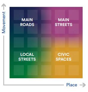
Table 3.2: Movement and Place Street Typologies
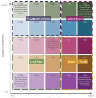
Movement Corridors
Provide safe, reliable and efficient movement of people and goods between regions and strategic centres and mitigate the impact on adjacent communities.
Vibrant Streets Significant complex places that attract both large numbers of people and move large numbers of people by various modes from all over the region. Vibrant Streets aim to ensure a high quality public realm with a strong focus on supporting businesses, traders and neighbourhood life.
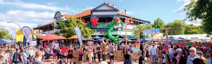
Local Streets Provide quiet, safe and desirable residential access for all ages and abilities. Local Streets aim to foster community spirit through facilitating local access.
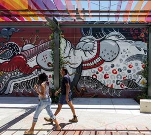
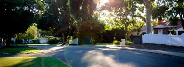
Streets for People Significant places which attract large volumes of people and facilitate pedestrian access and activity.
Figure 3.3: DoT Draft Preliminary Movement and Place Matrix
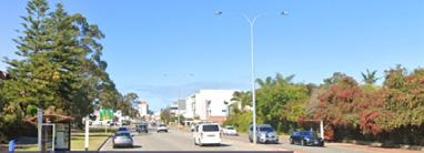 Figure 3.4: Movement and Place Example Street Typologies
Movement Corridors - Canning Hwy
Local Streets - Bone St
Figure 3.4: Movement and Place Example Street Typologies
Movement Corridors - Canning Hwy
Local Streets - Bone St
38 | TOWN OF VICTORIA PARK INTEGRATED TRANSPORT STRATEGY
Vibrant Streets - Albany Hwy Streets for People - ROW52
3.3.2.1 Movement and Place Assessment Methodology
The Movement and Place assessment included an assessment of the Town’s existing and future street networks.
• The Existing assessment involved the classification of the Town’s existing ‘Places’, classification of the Town’s existing transport network from a place perspective and the classification of the Town’s transport network from a movement perspective. These assessments were brought together to develop the Movement and Place classifications for each street within the Town, using the four street typologies described in Table 3.2.
• The Future assessment involved the classification of the Town’s future ‘Places’ which was then used to consider the future movement and place street typology of each street within the Town.
3.3.3 User Mindset Approach
The ultimate goal of a transport system is to enable people access to places where they can live, work and play. As a result, understanding community needs, pain points and behaviours is imperative when designing future transport solutions. To ensure the Town’s transport network is designed with the needs of the community in mind, WSP combined outcomes from the community engagement, feedback from the Town’s project team and Australian Bureau of Statistics (ABS) census data to develop eight User Mindsets. This Strategy recognises that each individual has unique travel behaviours and therefore a unique set of needs and pain points. The User Mindset approach aims to ensure the Strategy’s initiatives meet the varying needs of the community.
The eight User Mindsets were used as a tool in the visioning workshop to ensure the network reflects the many physical, social and emotional factors which influence the way users travel and enjoy places. These mindsets were also used to identify and test initiatives to improve user journeys.
4 About the Town of Victoria Park in 2021
4.1 The People
To aid in achieving the State’s vision of sustainable growth under the Perth and Peel @ 3.5 Million Sub-Regional Planning Framework, the Town’s Local Planning Strategy forecasts a population increase from 36,647 in 2016 to 49,913 in 2031, representing a 36% net increase in population. The Town has a significantly higher proportion of residents within the 20 34 and 85+ age groups in comparison to the Greater Perth and the national average 1. However, there is a lower proportion in the 5 19 age group indicating that there is a small school aged population, which is reflective of the relatively high proportion of couples who have no children.
Of the working age residents (aged 15 years and above), 58% work full time and 29% work part time, which is comparable to the Greater Perth and national averages. This compares to 62% full time and 27% part time working residents in 2011 reflecting a trend to a more “casualised” workforce. A high proportion of the Town’s residents are employed in arts and recreation services, accommodation and food services and education and training. This is likely attributable to the employment hubs of Optus Stadium, Crown Resorts, Albany Highway and Curtin University being located within the Town. Although there is no significant difference in proportion of the population attending an educational institution, there is a considerably higher percentage of the students enrolled in tertiary education compared to Greater Perth and the national averages. This is likely attributable to Curtin University, South Metropolitan TAFE and Swan TAFE Carlisle being located within the Town.
In 2016, 74% of workers in the Town reported that they commute by car (as a driver or passenger), a slight increase since the 2011 census which reported 72% of people commuting to work via car. Notably, a high proportion of the Town’s residents travel by bus (12%) and train (5%) to work, which is high compared to the Greater Perth average, sitting at 5% and 3% respectively. The Town’s public transport travel patterns have remained relatively stable over time, with 13% of residents catching the bus and 5% of residents using the train to access their place of work in 20111. In 2016, only 4% of residents reported commuting to work via walking, while only 3% cycled to work, remaining unchanged from the 2011 census reports.
There is a significantly lower proportion of dwellings in the Town that own more than one motor vehicle (46%) compared to the Greater Perth (60%) and the national (54%) averages. There has been a slight increase across the board, with 43% of residents owning more than one motor vehicle in 2011, 59% across the Greater Perth area and 53% nationally. Conversely, 9% of dwellings in the Town do not have access to a car, compared to 12% of dwellings in 2011.
40 | TOWN OF VICTORIA PARK INTEGRATED TRANSPORT STRATEGY
OF RESPONDENTS FROM THE COMMUNITY SURVEY INDICATED THAT WALKING IS THEIR MOST COMMON MODE OF COMMUTE
OF RESPONDENTS FROM THE COMMUNITY SURVEY INDICATED THAT CYCLING IS THEIR MOST COMMON MODE OF COMMUTE
OF RESPONDENTS FROM THE COMMUNITY SURVEY INDICATED THAT TAKING THE BUS IS THEIR MOST COMMON MODE OF COMMUTE
OF RESPONDENTS FROM THE COMMUNITY SURVEY INDICATED THAT TAKING THE TRAIN IS THEIR MOST COMMON MODE OF COMMUTE
RESPONDENTS FROM THE COMMUNITY SURVEY INDICATED THAT TAKING A PRIVATE VEHICLE IS THEIR MOST USED MODE OF TRANSPORT OVER 20% OF RESPONDENTS INDICATED THAT THEY WALKED DAILY & NEARLY 25% WALKED AT LEAST ONCE A WEEK
4% COMMUTE TO WORK VIA WALKING IN THE TOWN OF VICTORIA PARK (ABS 2016) 8% OF RESPONDENTS INDICATED THAT THEY CYCLED DAILY & 8% CYCLED AT LEAST ONCE A WEEK 7% OF RESPONDENTS INDICATED THAT THEY TOOK THE BUS DAILY, & 15% TOOK THE BUS AT LEAST ONCE A WEEK 2% OF RESPONDENTS INDICATED THAT THEY TOOK THE TRAIN DAILY, & 3% TOOK THE BUS AT LEAST ONCE A WEEK OVER 25% OF RESPONDENTS INDICATED THAT THEY DROVE A PRIVATE VEHICLE DAILY, & NEARLY 25% REPORTED THEY DROVE AT LEAST ONCE A WEEK ONLY 2% OF RESPONDENTS INDICATED THAT THEY TOOK RIDESHARE DAILY, BUT OVER 25% DID FORTNIGHTLY ABS 2016 AND 2011 CENSUS DATA WALKING TRAIN CYCLING CAR BUS COMMUTE VIA WALKING (ABS 2016) COMMUTE VIA BUS (ABS 2016) COMMUTE VIA TRAIN (ABS 2016) COMMUTE VIA CAR (ABS 2016) COMMUTE VIA CYCLING (ABS 2016) 3% GREATER PERTH 5% GREATER PERTH 3% GREATER PERTH 85% GREATER PERTH 1% GREATER PERTH 4% ACROSS AUSTRALIA 4% ACROSS AUSTRALIA 6% ACROSS AUSTRALIA 82% ACROSS AUSTRALIA THIS COMPARES TO THIS COMPARES TO THIS COMPARES TO THIS COMPARES TO THIS COMPARES TO & & & & & 11%
16%
2%
52%
3%
12%
5%
74% COMMUTE
5% GREATER PERTH 8%
COMPARED
& 9% OF
IN
1%
*These
42 | TOWN OF VICTORIA PARK INTEGRATED TRANSPORT STRATEGY
19%
OF
COMMUTE TO WORK VIA CYCLING IN THE TOWN OF VICTORIA PARK (ABS 2016)
COMMUTE TO WORK VIA BUS IN THE TOWN OF VICTORIA PARK (ABS 2016)
COMMUTE TO WORK VIA TRAIN IN THE TOWN OF VICTORIA PARK (ABS 2016)
TO WORK VIA CAR IN THE TOWN OF VICTORIA PARK (ABS 2016) (ABS 2016)
IN AUSTRALIA
TO
DWELLINGS
THE TOWN DON’T HAVE ACCESS TO A VEHICLE
ACROSS AUSTRALIA
statistics do not include people who stated they use two or more modes to travel to work.

BELMONT PARK OPTUS STADIUM CROWN PERTH MATAGARUP BRIDGE BURSWOOD STATION PERTH STADIUM STATION N VICTORIA PARK STATION CARLISLE STATION OAT ST STATION WELSHPOOL INDUSTRIAL AREA PERTH AIRPORT 5KM PERTH CBD 1KM SHEPPERTONRD GRAHAM FARMER FWY ALBANY HWY WELSHPOOL STATION TAFE - CARLISLE TAFE - BENTLEY TECHNOLOGY PARK CURTIN UNIVERSITY VICTORIA PARK CENTRAL SWAN RIVER THE PARK CENTRE MINERAL RESOURCES PARK Figure 4.1: Town of Victoria Park –Place Plan Neighbourhoods Legend The Burswood Peninsula The Causeway Precinct Lathlain Carlisle Welshpool Victoria Park East Victoria Park St James Curtin University & Bentley 44 | TOWN OF VICTORIA PARK INTEGRATED TRANSPORT STRATEGY
4.3 The Existing Transport Network
The transport network is a critical function of any locality as it enables people to access places and services and facilitates the movement and delivery of goods. The Town recognises the availability of road space is finite, which poses challenges to accommodating all user groups on all roads within the Town. However, through effective management and design of the transport network and well-informed decision making, therein lies an opportunity to influence peoples’ choices when it comes to selecting a preferred mode of travel.
The mode of transport most frequently used to travel to work by residents of the Town is car, according to the 2016 ABS Census data. However, encouragingly, the data also reveals that a higher proportion of the Town’s residents utilised active and public transport modes to commute to work, when compared to Greater Perth. The Town has identified the desire to build on this, and in line with the objectives of this Strategy the Town is keen to actively work towards shaping a transport network that encourages growth in active and public transport modes.
The following section outlines the Town’s existing transport network and relevant transport context by mode.
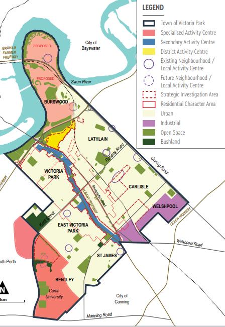
4.3.1 Walking
The Town of Victoria Park contains an extensive network of footpaths and pedestrian facilities, which is primarily under the responsibility of the Town. The Town’s street network is primarily a grid system which creates a walkable and navigable street environment. This network layout in turn encourages development to occur in line with the walkable neighbourhood model. These roads play a key role in defining the character of the Town, as they present the opportunity to be utilised for walking and cycling, as well as provide a place function.
Walking is an intrinsic feature of all transit trips, as people walk to access other modes such as buses or trains. The community engagement survey identified that 20% of respondents walk daily, whilst 11% stated walking as their preferred mode of commute. However, according to the 2016 ABS Census, only 4% of residents of the Town chose walking as their preferred mode to travel to work.
There are a number of high-quality recreational paths within the Town, including the Burswood Park Walk along the Swan River foreshore and Crown Perth entertainment complex. These recreational paths connect along the foreshore with neighbouring local governments and attract visitors from the broader Perth region to the Town.
Although many streets within the Town have high quality footpaths on both sides of the road, some streets provide no or substandard footpath infrastructure that create an undesirable walking environment. In addition, there are some areas that lack adequate crossing, weather protection and wayfinding facilities that hinder a person’s walking experience. This was demonstrated in the outcomes of the community engagement with almost all comments (~90%) made about current issues and opportunities for the Town related to pedestrian and cycling connectivity, facilities or safety.
Figure 4.2: Draft Local Planning Strategy Activity Centres
46 | TOWN OF VICTORIA PARK INTEGRATED TRANSPORT STRATEGY
There are a number of local attractors and key destinations which encourage residents to access them via walking, including the Albany Highway Activity Centre. Recent pedestrian counts along Albany Highway in 2019 and 2020 in two locations in Victoria Park (adjacent to Kabuki Japanese) and East Victoria Park (adjacent to City Farmers) are presented in Figure 4.3. This data demonstrates higher pedestrian activity in Victoria Park compared to East Victoria Park with a total of 1,207,757 pedestrians in Victoria Park in 2019, and 793,212 pedestrians in East Victoria Park in 2019. Pedestrian activity through 2019 and 2020 has remained relatively stable with the exception of March-May 2020 reduction due to the COVID-19 Pandemic lockdown.
In line with the vision of this plan and the State Government’s plan of achieving urban consolidation, the number of walking trips in the Town is forecast to increase significantly by 2031. In 2011, the Department of Planning’s STEM model indicates that the number of walking trips originating in the Town will increase by 76% by 2031. This indicates that people living within the Town want to walk, and therefore infrastructure should be provided to facilitate walking as a viable mode of transport.
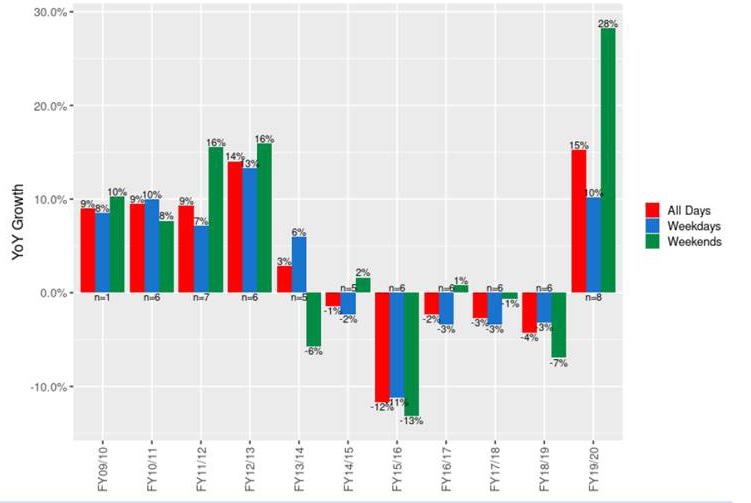
4.3.2 Cycling
The Town developed a joint Bike Plan with the City of South Perth in 2018. The Joint Bike Plan currently sets the long-term vision for the strategic cycling network throughout the Town, in line with the DoT’s Long-Term Cycling Network (LTCN) and the State Government’s Perth and Peel @ 3.5 Million Transport Plan. The development of the Bike Plan included an assessment of the existing cycling network and significant stakeholder and community engagement. Findings outlined in the Joint Bike Plan have been drawn upon to inform this Strategy including the outcomes of the community engagement. The complete Bike Plan is provided in Appendix A. The Town’s existing cycling network is comprised of various types of cycling infrastructure including off-road separated and shared paths, and on-road unprotected bicycle lanes (refer Figure 4.5).
A network of high-quality shared paths exists along sections of the Armadale railway, throughout the Burswood Peninsula and around Curtin University. High quality separated and shared paths are also provided along the Swan River foreshore, serving both commuting and recreational purposes. Additionally, unprotected on-road bicycle lanes are provided along some transport corridors within the Town, including Great Eastern Highway, Oats Street, Roberts Road and Miller Street, however these mainly attract confident cyclists due to the lack of separation from high speed vehicular traffic. There is also a localised footpath network, however these paths are of varying quality and are disjointed in many areas, meaning they do not cater high speed or long-distance cycling journeys. In summary, large portions of the Town’s cycling network are lacking in connectedness and separation from traffic, which is thought to be severely hindering cycling uptake.
Figure 4.3: Albany Highway Pedestrian Counts
48 | TOWN OF VICTORIA PARK INTEGRATED TRANSPORT STRATEGY
Figure 4.4: Perth CBD Bike Counter Trends (Source: Department of Transport)
The immaturity of the Town’s cycling network is reflected in the community engagement survey results. ‘Lack of safety and connectivity’ is cited by the Town’s residents as a key deterrent from choosing to cycle, with 90% of respondents raising this as an issue for cycling and walking throughout the Town. The community engagement survey also identifies that only 8% of respondents cycle daily. The 2016 ABS Census data further demonstrates the low levels of cycling uptake in the Town, with only 3% of the Town’s residents cycling to work.
To better understand broader trends in cycling, data was obtained from the Department of Transport, collected via 12 permanent counters located at fixed entrance / exit points to the Perth CBD. Figure 4.4 depicts year-on-year trends between the financial years of 2009/10 to 2019/20.
According to Figure 4.4, significant growth in cycling to / from the Perth CBD was observed between 2009/10 to 2012/13. Some decline occurred in 2013/14 and continued through to 2018/19, however, with a sharp reversal of these trends occurring in 2019/20. Further interrogation of the data revealed that although the occurrence of COVID-19 and the corresponding introduction of restrictions resulted in an increase in cycling in early 2020, growth was occurring prior to the introduction of these restrictions.
This uptick in cycling to / from the Perth CBD observed in 2019/20, combined with the fact that 19% of respondents to the community engagement survey stated cycling as their preferred mode of commuting in and around the Town, presents an opportunity to further encourage cycling as a legitimate mode of transport for the Town’s residents. Considering the close proximity of the Town to the CBD, and that approximately 43% of residents work within the Town and Perth CBD, there is a significant opportunity to increase cycling’s mode share.
As such, this Strategy seeks to complement the initiatives identified in the joint Bike Plan. This Strategy aims to support the development of a safe and legible cycling network, to attract a broad range of people with varying cycling abilities, including those that are less confident, and aims to encourage the Town’s residents to view cycling as a favourable and convenient mode of transport in and around the Town.
4.5: Existing Cycling Network
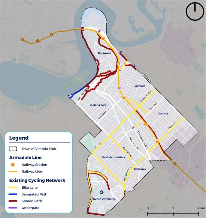
50 | TOWN OF VICTORIA PARK INTEGRATED TRANSPORT STRATEGY
Figure
4.3.3 Public Transport
Public transport has a fundamental role in connecting the Town of Victoria Park’s residents to key locations within the Town as well as to the wider Perth metropolitan area. Good access to public transport is not only essential for residents that may not have access to private transportation, the provision of high-quality public transport can also reduce the reliance on, or the need for, private vehicle usage and ownership. Encouraging greater uptake of public transport and reducing the number of private vehicles in and around the Town allows for better and more efficient use of the road space.
Train
The Town is currently serviced by four suburban train stations, these being Burswood, Victoria Park, Carlisle and Oats Street. The Town also has one special event station (Perth Stadium Station). All five stations are located within Zone 1 of the Transperth fare system. Figure 4.6 presents historical and forecasted patronage for the four suburban Stations located within the Town. Between 2015 and 2019, Oats Street, Carlisle and Victoria Park Stations experienced a decline in patronage, while Burswood station experienced a slight increase.
Looking forward to 2031, Burswood and Oats Street Stations are forecasted to have the greatest increase in patronage as a result of expected land use intensification on the Burswood Peninsula (a Specialised Activity Centre) and in the Burswood South and Oats Street precincts (District Centres).
As depicted in Figure 4.7 a significant portion of the Town has walkable access to a train station. This presents a significant opportunity for increased train mode share for both commuter and non-commuter trips. It should also be noted that the walkable catchments for Carlisle and Oats Street Station presented in Figure 4.7 are likely to change in the near future with the construction of the Victoria Park-Canning Level Crossing Removal Project (IALXR). This project will see the existing rail elevated on a viaduct structure and the existing Mint/Archer Street, Oats Street and Welshpool Road level crossings removed. The Victoria ParkCanning Level Crossing Removal project will see the reconstruction of Carlisle and Oats Street Stations as well as revitalised station precincts and access infrastructure.
Figure 4.6: Historical and forecast train patronage for suburban Stations located within the Town (source: PTA)
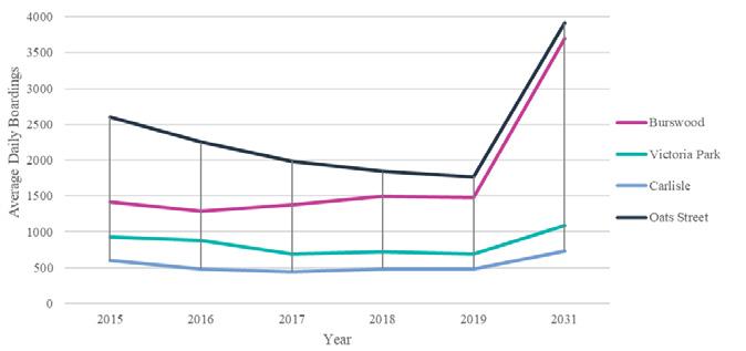
Figure 4.7: Station Walkability Catchment
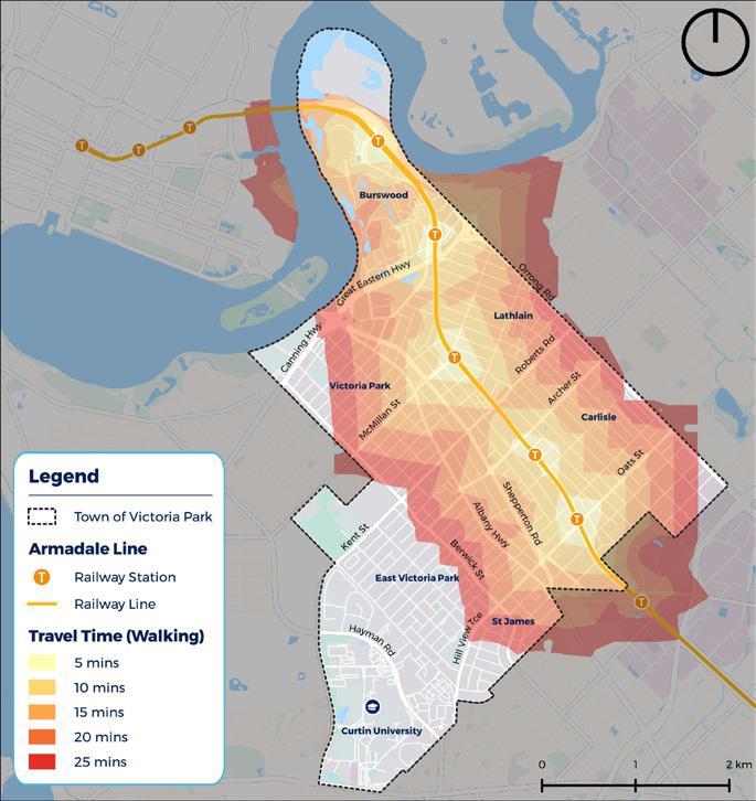
52 | TOWN OF VICTORIA PARK INTEGRATED TRANSPORT STRATEGY
Bus
The Town of Victoria Park is well serviced by a number of standard and high frequency bus routes with four bus interchanges located within the Town. This includes the Oats Street bus-rail interchange, the Victoria Park Transfer Station and two bus stations located at Curtin University Curtin University (adjacent to Hayman Road) and Curtin Central bus station). There are currently 30 standard bus routes that run within the Town, supporting trips to, from and within the Town of Victoria Park. Generally, these standard bus routes operate between 6am and 8pm during the week approximately every 20 minutes during weekday peak periods, 45 minutes during weekday off-peak times, and every 30 60 minutes on weekends.
There are 6 high frequency bus routes which operate everyday between 5am and midnight approximately every 5 minutes during weekday peak periods, 10 minutes during weekday off-peak times, and every 15 minutes on weekends. As shown in Figure 4.8, the existing high frequency bus routes run between:
• Route 910: Fremantle Station to Perth Bus Port via Canning Highway
• Route 930: Thornlie Station to Elizabeth Quay Bus Station
• Route 935: Perth Airport T3 And T4 to Perth Station
• Route 960: Curtin University Bus Station to Mirrabooka Bus Station
• Circle Route Services:
• Route 998 Clockwise
• Route 999: Anti-Clockwise.
Figure
4.8: Bus Network
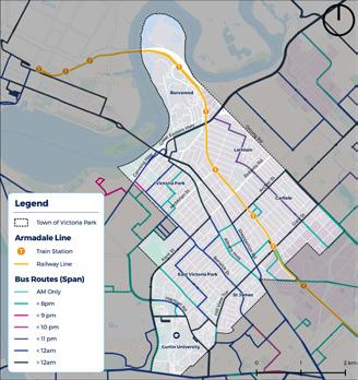
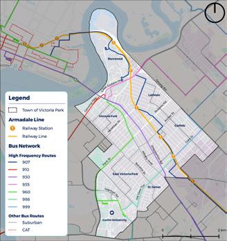
Figure 4.9: Bus Span
Public transport access assists in stimulating the Town’s night-time economy. Figure 4.9 demonstrates the bus span (time until a bus service operates until) throughout the Town. As demonstrated in Figure 4.9 not all key destinations are serviced by evening bus services, such as the whole portion of Albany highway, Burswood Peninsula and the Town’s various local centres such as Lathlain and East Victoria Park.
On an average weekday between 15th February and March 9th, 2021, there were 12,927 bus boardings and 12,951 bus alightings within the Town (provided by Transperth). It should be noted that these numbers may be slightly reduced due to the impact of COVID-19. Bus stop usage is concentrated along key movement corridors within the Town, including Albany Highway, Shepperton Road and Canning Highway. Excluding the stops located at bus interchange stations, the top 5 most utilised stops within the Town are outlined in Table 4.1.
Bus services within the Town also provide a great way to access the train network. Oats Street Station is the only station within the Town which has a formalised bus interchange and each weekday, on average 38% of train passengers boarding at Oats Street Station have accessed the station via bus (equivalent to 665 daily boardings). Burswood Station, Victoria Park Station and Carlisle Station have no formal bus interchange however a number of passengers still access the station via bus. Figure 4.10 demonstrates the percentage of overall train passengers who accessed the station by bus from 2015 – 2019. On an average weekday in 2019, 14% of passengers accessing Burswood Station did so by bus, 2% at Victoria Park Station and 6% at Carlisle Station.
Figure 4.10: Bus to Train Boardings at Stations within the Town (source: PTA)
Table 4.1: Five most utilised Bus Stops within the Town of Victoria Park
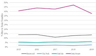
STOP AVERAGE DAILY BOARDINGS
11731: Albany Highway after Leonard Street 221 boardings
11712: Albany Highway before Duncan Street 187 boardings
11726: Albany Highway after Mint Street 144 boardings
14453: Great Eastern Highway before Cornwall Street 127 boardings 10145: Shepperton Road after Harper Street 121 boardings
54 | TOWN OF VICTORIA PARK INTEGRATED TRANSPORT STRATEGY
4.3.4 Road Safety
The road network of the Town of Victoria Park is largely reflective of a grid type street network that provides a high level of vehicle connectivity between the access and local distributor network and the higher order Distributor A and B roads. The higher order distributor roads generally carry the most traffic, and therefore generally have higher posted speed limits. Albany Highway is a key transport corridor within the Town and has a posted speed of 40km/h which reflects the placebased function and character of this street.
The Western Australian Driving Change Road Safety Strategy for Western Australia 2020 2030, sets out the State’s vision for reducing the number of people killed, severely or seriously injured by 50 70% by 2030. The foundation for this plan is the internationally recognised Safe System approach which identifies strategies to improve safety throughout road system. These strategies are not only centred around road network improvements, but also encouraging safer vehicles, safer speeds and safer driver behaviour.
Although the number of road users has increased in the Town over the past 5 years, the number of crashes has declined, as shown below in Figure 4.11. In terms of number of crashes, the Orrong Road / Francisco Place intersection ranks 61 in terms of crash frequency for the Perth Metropolitan Area for the period between 2015 2019. The Town has 73 Blackspot road sections (WA) and 75
Blackspot intersection sites. Over the 2015 2019 period, there was a total of 38 crashes involving a pedestrian, of which 53% occurred at intersections. There was one recorded pedestrian fatality over this period, and 58% of crashes involved hospitalisation.
The top 10 intersections with the highest casualty crash rate in the Town over a 5 year period between 2015 2019 include:
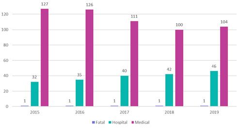
• Orrong Road / Francisco Place
• Orrong Road / Oats Street
• Great Eastern Highway / Graham Farmer Freeway
• Canning Highway / Berwick Street
• Albany Highway / Welshpool Road
• Orrong Road / Alexander Road
• Kent Street / Berwick Street
• Albany Highway / Mint Street
• Roberts Road / Orrong Road
• Manning Road / Waterford Avenue / Kent Street
Figure 4.12 provides a heatmap of crashes within the Town over a 5 year period between 2015 2019.
Figure 4.12: Heatmap of crashes within the Town of Victoria Park (between 2015 2019).
4.11:
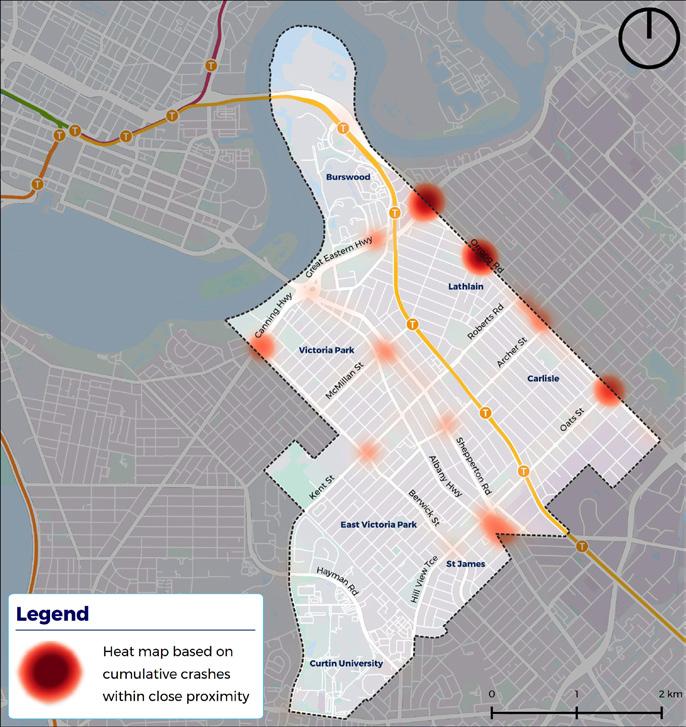 Figure
Number of Crashes within the Town between 2015 2019
Figure
Number of Crashes within the Town between 2015 2019
56 | TOWN OF VICTORIA PARK INTEGRATED TRANSPORT STRATEGY
4.3.5
Private Vehicles
The road network within the Town of Victoria Park plays a key role in the movement of traffic around the wider Perth area, due to its strategic location. The Town’s road hierarchy is depicted in Figure 4.13 and speed limits is outlined in Figure 4.14. The Town is served by a number of Primary Distributors which have a primarily movement function. The main arterial roads that move people to, from and within the Town include Shepperton Road which provides a transport link to the CBD and Albany Highway, Great Eastern Highway and Orrong Road which provide a connection to Perth Airport, and Canning Highway which links Albany Highway to Fremantle.
Albany Highway is a District Distributor road that runs north-south through the Town. Albany Highway not only provides an essential transport link for private vehicles, it is also a high frequency bus route and the town centre for the Town attracting both local residents and visitors from other parts of Perth. Key local connectors within the Town include Kent Street, Berwick Street and Hayman Road. The majority of the roads within the Town are residential access roads and laneways. The network is largely reflective of a grid system, which generates efficient vehicle movements and promotes walkability.
There are also a number of ongoing future road network plans that aim to improve safety for all road users. The Orrong Road Planning Study is centred around improving this corridor’s function as a transport and freight corridor, as well as improving travel times. Whereas, the Archer and Mint Street Upgrade Design Project is centred around making this street more people focused and activating the transit-oriented development within Carlisle. The IALXR will see the removal of eight level crossings along the inner section of the Armadale Line. Removing these level crossings will improve road safety, ease movements in the area, modernise stations and create versatile public spaces for the community.
Figure 4.13: Road Hierarchy
The 2016 ABS Census indicates that commuting by car as a driver or passenger is the Town’s most popular mode of transport (62%), marginally increasing by 1.5% from the 2011 Census. In addition, the number of households owning more than one motor vehicle has increased from 43% in 2011 to 46% in 2016 (ABS 2016). However, this is still low compared to the Greater Perth region whereby 60% of households reported to own more than one vehicle.
Without being managed effectively and consciously, car parking has significant potential implications for the Town’s transport network in terms of both Movement and Place. The Town has developed a comprehensive Parking Management Plan which outlines the Town’s strategy for parking related decision making and business planning. The Parking Management Plan seeks to respond to the key themes and objectivities identified in this Strategy to ensure that the provision and management of parking does not compromise the Town’s ambition of achieving a balanced transport network. The Town’s Parking Management Plan can be found in Appendix B of this Strategy.
There are various off-street and on-street parking facilities within the Town. There is also a mix of time-restricted, paid parking and unrestricted bays. The Town has a comprehensive Parking Management Plan that provides a framework for addressing existing and future issues with regards to medium- and long-term parking management within the identified hotspot areas.
4.3.6 Accessibility Based Analysis
To understand accessibility to key activity centres within the Town, WSP modelled the Town of Victoria Park’s accessibility by foot, cycling and public transport – the Town’s prioritised transport modes.
The WSP Customer Connectivity Tool measures active and public access to activity centres, commercial centres, health and education facilities. It does this by determining how far a person can travel by walking, cycling or public transport within a given travel time, including transfers between services and walking time to/from stops or stations.
Traditional public transport metrics that focus on simple measures, like stop coverage and service frequency, do not consider how customers use the transport network in their everyday lives. The Customer Connectivity Tool measures the quality of access that customers have across the whole network, understanding how they get to the places that are important to them.
For the Town’s Strategy, the Customer Connectivity Tool was used to understand how many activity centres customers can access across the Town within a 15-minute journey time by walking, cycling and public transport. The activity centres used in this assessment include Albany Highway in Victoria Park (adjacent to Victoria Park Central), Albany Highway in East Victoria Park (adjacent to The Park Centre), Albany Highway in St James (intersection of Alday Street and Albany Highway), Curtin University / Technology Park (intersection of Hayman Road and Kent Street), Burswood Peninsula (Perth Stadium Station), Burswood South (intersection of Burswood Road and Benporath Street).
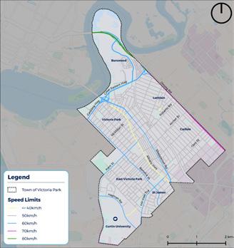
Figure 4.14: Speed Limits
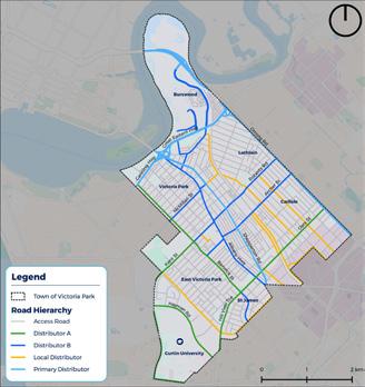
58 | TOWN OF VICTORIA PARK INTEGRATED TRANSPORT STRATEGY
4.3.6.1 Walking
15-minute walking accessibility is focussed on each individual activity centre to demonstrate the extent of the Town which has access to an activity centre. The vast majority of the Town has 15-minute access to at least one activity centre via walking, with the exception of Lathlain and Carlisle (north-east of the railway line) and western portion of St James. The maximum number of activity centres a resident can access in 15-minutes is two, which is the case for members of the community who reside in Victoria Park and East Victoria Park adjacent to Albany Highway.
4.3.6.2 Cycling
The Town’s cycling accessibility is the most expansive pattern compared to public transport which follows rail and bus corridors. The centre of the Town has 15-minute access to all nominated activity centres via bicycle. In addition to this, almost the entire Town (with the exception of the eastern, western and northern corners) have access to three activity centres, with the inner area of the Town having access to the most activity centres. Residents who live to the east and west of Albany Highway have access to five activity centres and a small portion of residents located near the Victoria Park train station have 15-minute cycling access to all identified activity centres within the Town. This shows cycling’s untapped potential within the Town.
Figure 4.15: Access to Activity Centres within 15-minutes by walking

Figure 4.16: Access to Activity Centres within 15-minutes by cycling

60 | TOWN OF VICTORIA PARK INTEGRATED TRANSPORT STRATEGY
4.3.6.3 Public Transport
The Town is serviced by the Armadale Line and an extensive bus network, which provides a large portion of the Town with access to at least one activity centre in 15-minutes, with the exception of a small portion of Carlisle and a large portion of Lathlain. Residents located to the east of the railway line have the poorest access to activity centres which demonstrates that the existing bus network servicing Carlisle and Lathlain does not provide access to activity centres within the Town of Victoria Park. The central area of the Town including Victoria Park and East Victoria Park is most highly connected to activity centres via public transport with access to four or five activity centres. Figure 4.17: Access to Activity Centres within 15-minutes by Public Transport
4.4 Existing Movement & Place Assessment
To understand how the Town’s transport network can better support achieving desired place outcomes, this Strategy used a Movement and Place Framework to map the Town’s places and streets for existing and future conditions. The Movement and Place classifications developed in collaboration with the Town’s project team are shown in Figure 4.18.

The majority of the streets within the Town are currently classified as ‘Local Road’ with a low movement and low place function. These streets provide local access throughout the Town, primarily facilitating access to residential areas. Key ‘Movement Corridors’ within the Town include Orrong Road, Shepperton Road, Canning Highway, Great Eastern Highway, Burswood Road, Victoria Park Drive, Miller Street, Oats Street, Briggs Street, Kent Street, Berwick Street and Hayman Road. The principal role of these streets is to facilitate high levels of movement throughout the Town by all modes of transport. A number of these corridors are classified as Primary Roads (Orrong Road, Great Eastern Highway, Oats Street and Shepperton Road) which play an important role in facilitating regional movement to, from and through the Town. In addition to vehicle movements, a number of these streets facilitate a high number of bus services providing access to key destinations such as Curtin University, Albany Highway, the Perth CBD and Oats Street train station. However, these streets do not present inviting and comfortable environments to attract people to dwell in.
Streets within the Town which demonstrate both a high place and high movement function are identified as ‘Vibrant Streets’. Such streets include portions of Archer Street, Basinghall Street and Sussex Street.
The Town is centred around Albany Highway which facilitates a high movement and high place function, thus identified as a ‘Vibrant Street’. Albany Highway facilitates high pedestrian, bus and vehicle movements providing a range of access options to the Street. In addition to this, there is a high level of place activity with entertainment, dining and community services located along the street. Conflicts between the high place and high movement functions exist along Albany Highway and require a bespoke planning and design response to balance both functions.
While the adjoining streets to Albany Highway have some high-quality streets, which reflect their place value including Basinghall Street and Sussex Street, others reflect the street typology of a local road. There are opportunities for Albany Highway’s adjoining streets to support both the movement and place function of Albany Highway.
Row52, Lathlain Place and a portion of The Circus are currently the Town’s only ‘Streets for People’. These streets have a high place function which prioritise pedestrians and provide opportunities for the community to dwell and spend time in.
62 | TOWN OF VICTORIA PARK INTEGRATED TRANSPORT STRATEGY
4.5 User Mindset Assessment
Eight User Mindsets have been developed to assess the Town’s existing transport network and its ability to serve user needs. The user’s help to generate the type of trips that customers may want to make around, to and from the Town and highlight the extent to which the existing network can be used for these trips.

These User Mindsets were developed considering community engagement findings, feedback from the Town’s project team and ABS census data. The User Mindsets were then further refined based on the Strategy’s visioning and objective workshop held with the Town.
Based on the above, the following User Mindsets were adopted as a representative sample of the Town’s community to test the Strategy development:
• Student at Curtin University – Chosen based on the key land use Curtin University, and because 33% of people within the Town of Victoria Park attend an education institution (with around a third of this group attending a tertiary or technical institution).
• Working Professional – Chosen to represent the Town’s most common occupation type with 29% of the Town’s employed residents being working professionals, compared to 22% for the Greater Perth region.
• Aged care resident – Chosen to represent existing demographics and future shift to an aging population, who have very specific transport network needs. There is a high proportion of aged care facilities located within the Bentley neighbourhood with 21% of the people in Bentley aged 65 years and over. This is compared to 13% for the Town and 14% of the Greater Perth region.
• Academic at Curtin University – Chosen to represent the 2.9% of the Town’s employed residents who are employed within the Higher Education industry (and an even higher percentage in St James at 3.5%).
• Parent and part-time hospitality worker –Chosen due to the significant eating and entertainment destinations within the Town as well as the requirement of the network to cater for those commuting to work outside of peak times.
• Construction Worker – Chosen to represent a smaller proportion of employed residents within the Town (13%) compared to the Greater Perth region (16%). However, this Strategy aims to cater for all members of the Town’s community as well as those travelling for work within the Town.
• Business Owner – Chosen to represent the various small and local businesses within the Town who contribute to a thriving Town.
• Customer Service Professional – Chosen to represent someone who works from home for a call centre and has a vision impairment to ensure this Strategy is inclusive to all members of the community and their individual travel needs.
These User Mindsets were profiled as set out in Table 4.2, defining their behaviours, needs/ goals and pain points experienced while moving through, to/from and within the Town.
Figure
4.18: Existing Movement and Place classifications
64 | TOWN OF VICTORIA PARK INTEGRATED TRANSPORT STRATEGY
Table 4.2: User Mindsets
PROFILE BEHAVIOURS NEEDS/GOALS PAIN POINTS
• Uses public transport to access Curtin University.
• Works part time at Crown Perth.
• Seeks reliable and frequent peak and offpeak bus services as class start and end times vary.
LEIGH
Student at Curtin University (20-28yo)
“I’m travelling to Curtin University for my 11am class.”
• Well-lit bus stop facilities and high-quality supporting path network.
• Infrequent services during off-peak periods, unreliable services during peak periods resulting in being late to class.
• Substandard bus stop facilities such as poor lighting and shelter.
PROFILE BEHAVIOURS NEEDS/GOALS PAIN POINTS

• Elderly resident who primarily uses local bus services to move around the Town.


• Primarily travels within the Town’s boundary.
• Convenient and close access to bus stops.
• Accessible access and egress to public transport services.
• Unable to find up-to-date travel information, relies heavily on timetables.

• Inadequate footpaths and crossing locations.
LOIS
Aged Care Resident (65+yo)
CARA Working Professional (25-35yo)
Cara Working Professional (25 35yo)
• A dedicated young professional office worker with no dependents.
A dedicated young professional office worker with no dependents.
Cycles into the CBD on days with good weather.
• Cycles into the CBD on days with good weather.
Uses peak bus or train services to access the CBD when not cycling.
• Uses peak bus or train services to access the CBD when not cycling.
“I travel from Victoria Park to the CBD for work each day.”
Elderly resident who primarily uses local bus services to move around the Town.
Primarily travels within the Town’s boundary.
A safe, direct and well connected cycle network.
• A safe, direct and well-connected cycle network.
• Efficient time competitive public transport services.
• Signs assisting with wayfinding on both the cycling and public transport networks.
Efficient time competitive public transport services. Signs assisting with wayfinding on both the cycling and public transport networks
Convenient and close access to bus stops.
Accessible access and egress to public transport services.
Lack of separated cycling infrastructure.
• Lack of separated cycling infrastructure.
• Walks to his work at Curtin university.
• Uses public transport to access social events in the evenings and on weekends.
OSCAR
Academic at Curtin University (30-45yo)
• A safe, intuitive, well connected path network.
• Good pedestrian crossing facilities on high trafficked roads.
• Path is disconnected with dangerous crossing points.
• High speed road environments and lack of pedestrian priority.
• Lack of public transport services and frequency after 8pm.
Unable to find up to date travel information, relies heavily on timetables. Inadequate footpaths and crossing locations.
Lois Aged Care Resident
(65+yo)
“I’m travelling to Victoria Park Central at 1pm to do my weekly shop.”
“I walk to Curtin University each day for work.”
66 | TOWN OF VICTORIA PARK INTEGRATED TRANSPORT STRATEGY
PROFILE BEHAVIOURS NEEDS/GOALS PAIN POINTS
• Works at a local café’ on Albany Highway where she travels via car after dropping two children at school.


• Available car park at destinations including long term staff bay within the Albany Highway activity centre.
• Congested road network.
• Difficult to navigate and unsafe roads.
PROFILE BEHAVIOURS NEEDS/GOALS PAIN POINTS

• Walks to local floristry business.
SOPHIE
Parent & Part Time Hospitality Worker (30-45yo)
“I take my children to school before travelling to work.”
• Due to convenience Sophie uses her car for most trips, no matter the distance, however, likes to walk around her local neighbourhood.
• Efficient road network.
• High speeds on local roads causing an unsafe walking environment.
FIONA
Business Owner (35-55yo)
“I’m travelling to Archer Street to
• Flower delivery van parked within the reserved staff parking overnight.
• Convenient cycling and public transport access to the business for the local community.
• Bike and car parking nearby to business and staff parking.
• Enjoyable walking environment to business.
• Lack of available parking for customers
• Long term parking adjacent to business entrance.
• Harsh walking environment in the summer months due to lack of shading.
GEORGE Construction Worker (20-35yo)

“I work on various construction sites and need to start work by 7am.”
• Travels early to construction sites which location varies around the Greater Perth region.
• Uses the bus network to access the Town’s entertainment locations in the evenings and weekends.
• Early morning and late at night frequency bus services.
• Reliable public transport network.
• Intuitive public transport network with easy to understand travel information as destination varies.
• Lack of flexibility of the transport network, usually always having to travel into the CBD.
• Lack of nighttime bus services to access entertainment destinations.
LILY Customer Service Professional (30-45yo)
• Works from home in customer service for a call centre.
• Uses public transport to travel around the Town due to a vision impairment.
• Public transport with universal access and auditory cues for stop and location information.
• Safe, local walking environment.
• Transparent information about accessing public transport including quality, continuity, topography and availability of ramps.
• Inconsistent public transport services and pedestrian access network.
my Floristry Business.”
“I work from home and use public transport to travel around the Town.”
68 | TOWN OF VICTORIA PARK INTEGRATED TRANSPORT STRATEGY
The typical journey for each User Mindset were mapped to illustrate the ability of the Town’s transport network to cater for each User Mindset. The User Mindset journeys shown in Figure 4.19 and Figure 4.20 showcase the diverse range of journeys within the Town. Findings from the User Mindset assessment have been used to identify challenges and opportunities relating to the Town’s transport network and have been integrated within Section 5.4 of this Strategy.
Leigh – catches the bus from East Victoria Park to Curtin University
Leigh – catches the bus from East Victoria Park to Curtin University
Cara – cycles along existing cycling route into the CBD or catches the bus (along Shepperton Rd)
Cara – cycles along existing cycling route into the CBD or catches the bus (along Shepperton Rd)
Lois – travels to Albany Highway Strip Bentley via bus
Lois – travels to Albany Highway Strip Bentley via bus


Figure 4.19: User Mindset Transport Journey Mapping
Oscar – walks to Curtin University for work from St James
Oscar – walks to Curtin University for work from St James


Sophie – drives to Lathlain Primary school for school drop off from Burswood
Sophie – drives to Lathlain Primary school for school drop off from Burswood

George – access the Armadale Line to travel to various construction sites, usually via the CBD
George – access the Armadale Line to travel to various construction sites, usually via the CBD


Figure 4.20: User Mindset Transport Journey Mapping
5 The Future of the Town of Victoria Park
5.1 Introduction
5.1.1 Future Aspirations for the Town

One aspect of the community engagement was seeking to understand the community’s aspirations for the future transport network. To understand this, the online survey included questions requesting the community to identify what transport network improvements they see as the most important. A significant proportion of comments related to better public transport provisions (cost/availability and network coverage). Improved cycling infrastructure including better on road bike lanes and, off-road cycle paths were also commonly mentioned by respondents. In summary, the key improvements identified by the community included:
• Increased public transport coverage and frequency;


• A safer and better connected cycling network;


• More attractive walking environments with greater tree canopy coverage; and
• The removal of vehicles from key destinations such as Albany Highway.
In addition to this, almost all respondents who noted their most common method of transport was private vehicle, when asked what would improve their transport journey, responded with methods to improve alternative modes (walking, cycling and public transport). This indicates a strong likelihood of mode shift if such things were improved.
In addition to the above findings, respondents of the survey were asked to rank what transport interventions are most important to improving their journey in their local area and within their local activity centre. The outcomes of these questions are provided in Figure 5.1. This demonstrates the order of improvement hierarchy identified by survey respondents and their differing priorities when considering their local area compared to activity centres within the Town.
Figure 5.1: Community ranked transport improvements within their local area and the Town’s activity centres

70 | TOWN OF VICTORIA PARK INTEGRATED TRANSPORT STRATEGY
5.1.2 Future Growth
As an inner-city community, the Town will experience a significant amount of growth as Perth nears a population of 3.5 Million by 2050. To appropriately plan for this growth, the Perth and Peel @ 3.5 Million Central Sub-Regional Planning Framework seeks to achieve a greater consolidated urban form. The Town will play a significant role in achieving this vision and is forecasted to accommodate an additional 19,320 dwellings (creating a total of 35,090 dwellings by 2050) and a population increase of 45,510 (creating a total of 77,230 residents by 2050).
After significant engagement with the community, the Town’s local planning framework sets out the key locations for this future growth to occur. More specifically, this growth is planned to be situated in identified Specialised, Secondary and District Activity Centres outlined in Section 4.2. In addition to this, the Town has identified a number of Strategic Investigation Areas which may account for some of this growth however these require further investigation and updates to the existing planning framework. In addition to these areas, Forecast.ID estimates a large proportion of this growth is expected to be centred around the Burswood Peninsula and Burswood South activity centres. This area of the Town is expected to experience an increase over 400% for both dwellings and population.


The National Institute of Economic and Industry Research (NIEIR) estimates there are currently 34,844 jobs within the Town as of 2020. The Perth and Peel @ 3.5 Million Central Sub-Regional Framework forecasts an additional 12,340 jobs by 2050 (from 2016) in key activity centres within the Town. The Curtin-Bentley Specialised Activity Centre is expected to provide a total of 23,710 jobs by 2050 (an increase of 9,740 jobs from 13,970 jobs today) and Secondary Activity Centre, Victoria Park is anticipated to provide 6,040 jobs by 2050 (an increase of 2,600 from 3,440 jobs today).
Figure 5.2: Estimated Growth in Dwellings (Forecast.ID)
5.1.3 The Town of Victoria Park’s key
projects and Programs
To support the future population and employment growth within the Town there are several significant projects and programs in various stages of planning. These projects and programs will have a transformative impact on the Town and will play a significant role in achieving the vision, themes and objectives of this Strategy. The key planned projects and programs are outlined below:
5.1.3.1 Projects
Victoria Park-Canning Level Crossing Removal Project
METRONET’s Victoria Park-Canning Level Crossing Removal will see the removal of six level crossings along the inner section of the Armadale Line. Removing these level crossings will improve road safety, ease movements in the area, modernise stations and create versatile public spaces for the community.
Package 1 includes the Mint Street (adjacent to Carlisle Station) and Oats Street (adjacent to Oats Street Station) level crossings, both of which are located within the Town, as well as Welshpool Road. This project will result in the relocation and reconstruction of Carlisle and Oats Street stations, provide new station access infrastructure and community facilities underneath the viaduct, as well as the closure of Welshpool Station.
Causeway Pedestrian and Cyclist Bridge
Orrong Road Planning Study
Orrong Road is a key road and freight corridor distributing vehicle traffic between the Mitchell Freeway and Graham Farmer Freeway to the north-west and Leach Highway, Roe Highway and Tonkin Highway to the south-east. Orrong Road is currently operating at capacity with 65,000 vehicles per day using the road. Main Roads WA have conducted a planning study which has included the development a concept design which sees the corridor transformed to an expressway built within a significant trench structure.
Archer and Mint Street Upgrade Design Project
Located adjacent to Carlisle Station, the Archer and Mint Street Upgrade Design Project involves the transformation of the street from car focussed to people focussed. This street upgrade will create a more activated transport-oriented development within Carlisle. This will be achieved with the provision of a protected bike lane, increased canopy coverage and greater pedestrian and cyclist priority at intersections.
Trackless Tram Consortium
Figure 5.3: Estimated Growth in Population (Forecast.ID)
The Causeway Pedestrian and Cyclist Bridge (CPCB) project involves the provision of a new active transport river crossing linking East Perth to Victoria Park via Heirisson Island. Comprising of two cable stay bridges, the proposed crossing will be located approximately 80 100m downstream of the existing Causeway traffic bridges. The CPCB will improve safety, capacity and connectivity for pedestrians and cyclists over the Swan River, providing a high-quality user experience attracting tourists and encouraging increased levels of cycling and walking.
The Town, alongside the City of Canning, City of Vincent, City of Perth, City of Stirling and Curtin University have formed a consortium advocating for the provision of a trackless tram in Perth. It is envisioned that a trackless tram system in Perth would provide Perth with a mid-tier transit system supporting the city’s existing heavy-rail and bus networks. The route is planned to operate between Cannington and Scarborough Beach providing connections within the Town at Curtin University and the Victoria Park Bus Transfer Station.
72 | TOWN OF VICTORIA PARK INTEGRATED TRANSPORT STRATEGY
Burswood Station Upgrade

It has been identified that Burswood Station will need to be upgraded to accommodate 6 car trains operating at a higher frequency (up to 15 trains per hour) at a future point. Beyond completing an initial planning study, in which the Town of Victoria Park was involved, there has not been any further planning work or updates to timeframes to progress the project into delivery.
The same applies for the Platform and Signalling Upgrade Program (PSUP), with Burswood and Victoria Park Stations both being investigated under the PSUP scope. This is a long-term planning project, with no current timeframes or funding committed to the delivery of physical works.
Speed Reduction in Activity Centres and Residential Streets
The Town supports the need for slower speeds within residential inner city Perth (40 km/h), with a further reduction to 30km/h within key activity centre areas where there is a concentration of pedestrian activity. Lower speeds in residential and activity centre areas will result in making streets safer for all road users, contributing to more connected communities, reduced greenhouse gas emissions and will have only minor impacts on average travel times.
Perth Stadium Station function
Perth Stadium Station is currently only serviced by trains during events. In the longer term, as the planned urban development is realised around the Stadium and Belmont Park site, consideration should be given to transitioning Perth Stadium Station from a ‘special events’ station to an ‘all stops’ station, to service the growing population around the Station as well as Burswood Peninsula as a key destination.

Burswood Road Streetscape Improvement Plan

The revitalisation of streets in the Burswood South neighbourhood area will help to realise this area’s potential as a major mixed use centre for commercial, office and apartments close to the Perth CBD and within easy reach of the Perth International Airport.

The plan will outline concepts for improving landscaping/street trees, public lighting, footpaths and verges, public seating, pedestrian crossing points, location of car bays car bays (on-street), road pavement widths and treatments, bike access and movement and delivering public art. It will include preliminary costs of implementation and recommended stages of work over several years and will make recommendations regarding undergrounding of power.
Albany Highway Precinct Structure Planning
The Albany Highway Precinct runs through the heart of the Town from Canning Highway to Welshpool Road. In accordance with the Town’s Local Planning Strategy, the Town is currently undertaking precinct structure planning for the Albany Highway Precinct to ensure this area can continue to thrive as a vibrant Activity Centre, accommodating residential, business and visitor growth. This project will also see the delivery of a range of public realm and streetscape improvements.
 Artist impressions, subject to change.
Design: ipv Delft international Indicative image only – subject to change
Artist impressions, subject to change.
Design: ipv Delft international Indicative image only – subject to change
74 | TOWN OF VICTORIA PARK INTEGRATED TRANSPORT
Figure 5.6: Orrong Road Planning Study Draft Concept Plan Visualisation (Source: Main Roads)
STRATEGY
Programs
Old Spaces New Places Program
Old Spaces New Places (OSNP) is a Town-initiated program that identifies spaces that can be renewed and upgraded for greater community use and benefit. The Program rejuvenates streets and public spaces to meet the demand for high quality people focused places. With the first OSNP project at IGA laneway already complete, the Town will continue to roll out the program across its commercial precincts. The next project for delivery is located at the western end of Albany Highway (near Mackie and Rushton Streets).
Vic Park Leafy Streets Program
The Town’s Urban Forest Strategy has set a target for the Town to achieve 20% urban tree canopy coverage while increasing tree diversity, beautifying neighbourhoods and improving urban health. To achieve this, the Town has developed the Vic Park Leafy Streets Program which is an annual initiative run by the Town’s Urban Forest Program. Through the Leafy Streets Program, the Town works alongside the community to identify suitable tree planting locations and select appropriate species to create an urban forest in the Town’s local streets.
Bike and eRideable Infrastructure
The Town will fast-track development of a number of priority bike routes, which were identified as priorities by the community, as the first steps towards developing a comprehensive network of priority routes for bikes and eRideables. The Town will continue to seek support from the DoT in delivering on this network, and it is expected that the DoT’s will focus on support for the Long Term Cycle Network.


Skinny Streets
The Skinny Streets movement developed in the United States in the early 1990s, with the aim of reducing widths in standard municipal street designs. This was in response to community concerns about traffic speeds and road safety.
The Town’s Skinny Streets program will result in narrowing certain streets within the Town, to encourage lower traffic speeds, in order to improve road safety and amenity for all street users. The program will consider the conditions under which skinny street treatments will be applied and develop appropriate street designs. This may resemble a Dutch-style “Woonerf” street, or other shared space concept.
The Town will develop this program in consultation with Main Roads, which has considerable regulatory powers over local government roads, including speed zoning and all regulatory signs and lines.

5.1.3.2
Figure 5.7: LTCN Function
Figure 5.8: Long Term Cycling Network
Dutch-style Woonerf Street
76 | TOWN OF VICTORIA PARK INTEGRATED TRANSPORT
Narrowed street entrances
STRATEGY
5.2 Future Trends
The Town’s Strategic Community Plan outlines seven global megatrends which are likely to affect the Town. Three of these megatrends include changing demographics, technological advances and climate change, which directly impact the way people move around.
5.2.1 Changing Demographics
It is expected the population of the Town will grow from 35,000 in 2016 to 56,000 people by 2036, and to over 100,000 by 2050. Although, the age structure of the Town is expected to remain similar, and dominated by one or two person households, the Town is forecast to become more homogeneous in terms of socio-economics but more multi-cultural. This projected influx of new permanent residents will substantially increase the demand for key transport infrastructure and services throughout the Town. It is also imperative that transport choice is allowed for to support the diverse transport needs throughout the Town.
5.2.2 Technological Advances
Technological advances are leading to greater diversity, reliability and efficiency in transportation. Connectivity, automation, sharing and electric propulsion are driving change across all aspects of mobility, from the way we move around to how we plan and develop infrastructure for the future. In recent years there has been significant progress and uptake of emerging transport technologies such as micro mobility devices (including e-bikes and e-scooters), as well as drones and driverless vehicle technology. This strategy seeks to maximise the benefits of changes in technology to achieve the vision of the Town’s transport network.
5.2.3 Climate Change
In 2018 the Town of Victoria Park declared a climate emergency and made the commitment to become a zero-carbon local government by 2030. As such, the Town have recently developed a draft Climate Change Emergency Plan which sets out an action plan to achieve net-zero emissions by 2030. How and how far we choose to move around comprises a significant portion of our carbon footprint, which is estimated to be approximately 35% for the average Australian household (Environment Protection Authority, 2011). This strategy supports the actions identified in the draft Climate Change Emergency Plan and will play a vital role in facilitating the Town’s transition to net-zero emissions by 2030.
5.3 Future Movement & Place Assessment
The future Movement and Place classification designed in collaboration with the Town’s project team is shown in Figure 5.9.
In the future, the Town will experience an even greater place significance. Albany Highway will continue to be the centre of the Town with increased movement and place activity. It is envisioned that parts of Albany Highway will take on a greater place function which will require a decrease in the movement function, creating ‘Streets for People’. Locations where this is envisioned include the Victoria Park Town Centre (between Teddington Road and Harvey Street) and East Victoria Park Town Centre (between Basinghall Street and Dane Street). Adjoining Basinghall Street is also envisioned as a future ‘Street for People’ with a high place function.
The remaining portions of Albany Highway will continue to serve as a ‘Vibrant Street’, however as the Town experiences its forecasted growth, precinct planning and street improvement upgrades will be required along Albany Highway to maintain a healthy balance between its movement and place function.
Local neighbourhood centres in Lathlain, Carlisle and East Victoria Park will play a greater play role in the future. The centre of these local neighbourhood centres has been identified as future ‘Streets for People’ which includes a Lathlain Place, a portion of Gallipoli Street in Lathlain and Etwell Street in East Victoria Park. The Victoria Park-Canning Level Crossing Removal project will also transform the land under the rail viaduct adjacent to a portion of Rutland Avenue as a ‘Street for People’. In addition to this, the Belmont Park Structure plan sets out the road network for the area with an unnamed street envisioned as a future ‘Street for People’. These streets will play an important role in achieving the Town’s vision as a Dynamic Place for Everyone.
Increased place significance is also envisioned to occur along existing ‘Movement Corridors’. These streets with existing high movement function and a future high place function are identified as future ‘Vibrant Streets’. This includes, Burswood Road, Griffiths Street and Oats Street. Burswood Road and Oats Street are located within ‘Precinct Planning Areas’ identified within the Town’s Draft Local Planning Strategy. Griffiths Street is located within the Burswood Peninsula which is a proposed Specialised Activity Centre. An unnamed ‘Integrator B’ road within the Belmont Park Structure Plan is also identified as a future Vibrant Street. These streets will play a significant role in accommodating movement to, through and within these key destinations as well as acting as destinations themselves.
The existing ‘Movement Corridors’ will continue to provide a high movement function within the Town. The Town will continue to work in close partnership with Main Roads WA, DoT and PTA to ensure the primary movement network continues to serve the Town’s to, through and within movement requirements.
78 | TOWN OF VICTORIA PARK INTEGRATED TRANSPORT STRATEGY
5.3.1 Design Guidance
The Movement and place assessment has identified a number of locations where the existing street typology is required to service a different movement and/or place function in the future. To enable this, the Town is required to implement movement and/or place improvements to these streets. This will ensure that the Town’s street network reflects the movement and place function identified within the future Movement and Place assessment. To achieve this, Table 5.1 outlines clear design guidance for each of the four street typologies. This guidance should provide the basis for implementation of the future Movement and Place network. However, when developing a design for these streets, additional consideration should be given to the local context of each individual to ensure a bespoke design response.
Table 5.1: Movement and Place Design Guidance
STREET TYPOLOGY POTENTIAL TRANSPORT RELATED DESIGN RESPONSES
Local Roads
• Low vehicle speeds and traffic volumes;
• Footpaths on at least one side of the road;
• Extensive use of local area traffic management treatments;
• Skinny streets;
• Minimal kerb radii at intersections to encourage vehicle traffic to slow down when turning into side streets;
• Shared space environments;
• Active frontages; and
• Extensive tree canopy coverage creating a comfortable pedestrian environment.
Movement Corridors
• Wider lanes facilitating higher vehicle speeds;
• Dedicated turning pockets at major intersections;
• Clear sightlines for all road users;
• Bus/transit priority infrastructure on key transit routes;

• Wide footpaths that facilitate safe and convenient access to public transport stops;
• Cycling infrastructure that is physically separated from motorised traffic; and
• Provision of safe pedestrian and cyclist crossing points at key locations.
Figure 5.9: Future Movement and Place Classification
80 | TOWN OF VICTORIA PARK INTEGRATED TRANSPORT STRATEGY
STREET TYPOLOGY POTENTIAL TRANSPORT RELATED DESIGN RESPONSES
Streets for People
• Low vehicles speeds and traffic volumes,
• Pedestrian priority, including potential use of continuous footpath treatments across driveways and side roads;
• Ample areas to dwell with street furniture and active frontage to buildings on at least one side of the street space/plaza;
• Extensive tree canopy coverage creating a comfortable pedestrian environment;
• Provision of a transition zone between the ‘Street for people’ and higher movement streets using on-street vehicle parking and/or landscaping measures; and
• Good pedestrian connections to the broader pedestrian, cycling, transit and road network.
5.4 Challenges and Opportunities
The Town not only aspires to improve transport efficiency, but also improve journey experience and promote the uptake of active and sustainable transport modes. The aim of this is to increase sustainability, supporting a more healthy, accessible and liveable Town.
Transport challenges and opportunities have been identified through an understanding of the place-based context analysis presented within this Chapter. This analysis has drawn upon a range of data sources including site observations, community and stakeholder engagement outcomes, ABS Census data, transport network patronage data, accessibility based analysis and a Movement and Place assessment.
As an outcome of this analysis, the following table provides a summary of the Town’s transport challenges and opportunities which have informed the development of the vision and objectives of the Town’s transport network.
Table 5.2: Overview of Transport Challenges and Opportunities
Vibrant Streets
• Traffic calming promoting low vehicle speeds;
• Separated cycling infrastructure;
• Wide pedestrian footpaths / sidewalks with activated frontages on both sides of the street;
• Reliable bus services with potential bus priority measures at signalised intersections or on-road bus priority lanes;
• Bus stop facilities including timetable, seating, shelter, rubbish bin and real time information (when implemented in the future);
• Extensive tree canopy coverage creating a comfortable pedestrian environment;
• Convenient bicycle parking outside businesses and other points of interest;
• Street furniture and pockets of urban greenery providing opportunities for visitors to dwell;
• Minimal kerb radii at intersections to encourage vehicle traffic to slow down when turning into side streets;
• Bicycle parking along the street;
• Implementation of CPTED measures; and
• Provision of on-street parking between moving vehicles and pedestrians, with on-street parking managed by time-restrictions.
THEMES CHALLENGES OPPORTUNTIES
Walking
• Disconnected footpath network, lack of lighting and wayfinding in some areas throughout the town pose a challenge for walkability.
• Lack of canopy coverage in some locations creating a hostile walking environment.
• High speed and trafficked roads as well as the rail line creating barriers to walkability within the Town.
• Poor pedestrian connectivity from Curtin University to surrounding residential areas.
• Walking is the most common method of transport for 11% of survey respondents and 38% of respondents travel somewhere daily by walking, and 50% travel somewhere at least once a week by walking.
• There are a number of key destinations and local centres which are in walking distance of residential areas throughout the Town.
• Albany Highway is located in an opportunist location creating a town centre spine down the middle of the Town.
• Improve amenity through the provision of shade and lighting on local streets, as identified in the community engagement survey.
• Revitalise street environments to create streets for people that favour pedestrians, increase opportunities for businesses and enhance sense of community.
• Implementation of the Town’s Streetscape Improvement Program will deliver improved pedestrian environments in key locations.
82 | TOWN OF VICTORIA PARK INTEGRATED TRANSPORT STRATEGY
THEMES CHALLENGES OPPORTUNTIES
Cycling
• Absence of protected or dedicated cycling infrastructure throughout the Town, especially to key destinations.
• Substandard to absent endof-trip facilities at work places within the Town deterring people from cycling to their place of work.
• Lack of separated pedestrian and cyclist infrastructure throughout the Town creating opportunities for conflicts.
• Absence of a completed Principal Shared Path along the Armadale rail line.
• Difficulties in crossing high speed and trafficked roads.
• Absence of secure bicycle parking at key destinations within the Town deterring people from cycling to their destination.
• The Town’s community are interested in cycling with the community engagement findings demonstrating that cycling is the second most common method of transport (20%) and 32% of survey respondents noted that they cycle at least once a week.
• Cycling presents an attractive mode to access activity centres and key destinations located within the town.
• Established recreational shared path cycling network along the Swan River foreshore.
• Cycling can be combined with other transport modes to create multimodal journeys, which can be further enhanced through the provision of end-of-trip facilities.
• The emergence of e-bikes and other forms of micro-mobility creates more opportunities, overcoming the barriers of exercising before work and making topography less of a challenge.
• Implementation of the Skinny Streets program to improve attractiveness of cycling on local streets within the Town.
• Implementation of bike boulevards to improve cycling for all ages and abilities.
THEMES CHALLENGES OPPORTUNTIES
Public Transport
• Community perception of safety and security on public transport throughout the Town.
• Lack of bus service provision and frequency in the nighttime, creating a challenge for the Town’s night time economy.
• Lack of bus priority and prevalence of road connection on key movement corridors creates bus service delays.
• Unreliable bus services due to road congestion and lack of priority on the road network.
• Planning and the operation of public transport services is not the responsibility of the Town.
• The Level Crossing Removal Project as well as Burswood Station redevelopment project within the Town will see the redevelopment of Carlisle and Oats Street Stations as well as revitalised station precincts and new station access infrastructure.
• Frequent bus services to the Perth CBD and key locations within the Town such as Curtin University.
• Potential for a mid-tier public transport system within the Town to complement and support the existing network.
• The use of emerging technologies, including zero-emission buses, accurate real time bus location data, and permitting the use of forms of micro-mobility to improve connectivity.
• Opportunity to explore the provision of a CAT bus service or similar as identified through community engagement.
• Opportunity to improve access to public transport stops and interchanges to improve overall journeys.
Driving & Parking
• Driving remains the most popular mode of transport in the Town, making up 52% of survey respondents most common mode of transport and 62% of all journeys to work in 2016, increasing marginally from the 2011 Census.
• Vehicle ownership rates have also risen from 43% of households owning more than two motor vehicles in 2011 to 46% in 2016 (ABS 2016).
• Rat running of through trips creating congestion and safety issues on the Town’s local road network.
• Large provision of parking in areas of high place value and high activity such as within activity centres.
• Encourage mode shift from private vehicle to more active and sustainable modes for short trips within the Town.
• The implementation of planning for electric vehicles (EVs) to ensure the Town can cater for their growing use.
• Draw upon various methods including existing and emerging technologies for managing parking demand in the Town’s activity centres.
• Implementation of Skinny Streets program to improve road safety for all users and encourage mode shift.
• Frequently host car-free event days within the Town to demonstrate benefits of reduced vehicles on the network.
84 | TOWN OF VICTORIA PARK INTEGRATED TRANSPORT STRATEGY
#LOVEVICPARK victoriapark.wa.gov.au
Park
of loving Vic

