Public Health Geographic Information Systems
Fall: July 15
Spring: Nov 15
Summer: April 15
UIC's online Public Health GIS certificate program teaches you to use GIS data to help protect the health of people, the economy, and natural resources.
- Michael Calias, PhD
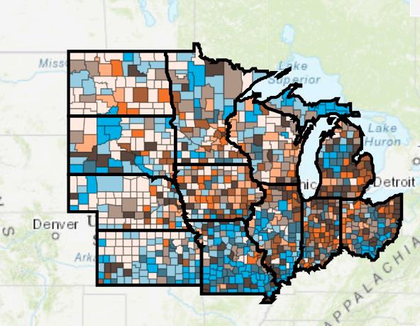
The PHGIS program has built a series of Midwest Comprehensive Visualization Dashboards (MCVD) focused on public and environmental health issues in this region The MCVD create visualizations that lead to operational insights that enhance data-driven decisions These dashboards are explicitly designed to overcome some limitations identified during the COVID-19 pandemic and the plethora of dashboards created at this time
The dashboard pictured above focuses on assisting public health professionals with the difficult task of prioritizing vaccinations in their counties. The new operational parameter included in this dashboard is a measure of vulnerability encapsulated by the CDC’s Social Vulnerability index. Interact with the dashboard @ https://bit.ly/3rnS8Jc
Public Health Geographic Information Systems
CERTIFICATE and COURSES
COURSE DESCRIPTIONS
HPA 436 | EOHS 436. GIS for Environmental and Public Health Professionals. 4 hours. Aims to promote a critical understanding of the basic practices and techniques associated with GIS applications in the environment and public health areas Required for students with little or no GIS experience
HPA 455. Geographic Information Systems Integrative Project. 2 hours. The integrative project aims to demonstrate a comprehensive mastery of the course materials, database theories, and GIS techniques by pursuing a project resembling those encountered by public health
HPA 480 | EOHS 475. Health Related Database Design and Analysis. 4 hours.
Introduces students to the design and analysis of health related relational and spatial databases Extensive computer use required Strong quantitative background recommended
HPA 564 | EOHS 564. Geographic Information System Application in Public Health. 3 hours.
Advanced level GIS course to promote a critical understanding of the major practices associated with GIS in the many application areas found in public health. Prerequisite(s): HPA 465 or HPA 436 or EOHS 436.
HPA 565. Datamining Applications in Public Health. 3 hours.
Presents the key public health information system sources, describes the process of datamining and introduces the student to a sample of datamining techniques. Prerequisite(s): BSTT 400.
HPA 592. Spatial Data Analysis and Visualization. 4 hours.
Application of spatial analysis techniques to visualize patterns, distributions, relationships of public health related data emphasizing their advantages and limitations. Prerequisite(s): Credit/concurrent registration in HPA 564 or instructor consent.
HPA 593. Social Vulnerability Analysis. 4 hours.
Study of advanced level social vulnerability analysis techniques and their application for the protection of communities Prerequisite(s): Departmental approval
Students must complete four courses (13 credit hours) and maintain a 3.0 (out of 4.0) GPA across all courses.
HPA 455 is required for all students. HPA 436 is required for students with little or no GIS experience. Choose from additional courses based on interest. The certificate can be earned in as little as one year.
Graduate credits earned may be transferred toward the fulfillment of a Masters or PhD degree at UIC (i.e. MPH, PhD in in Health Policy and Administration, or other)
Program Delivery
Completely online
Application Deadlines
Fall: July 15
Spring: November 15
Summer: April 15
Application
https://admissions uic edu/
Enrolling Semester
Fall, Spring, Summer


