M A URBAN DESIGN
NEWCASTLE UNIVERSITY

M A URBAN DESIGN
NEWCASTLE UNIVERSITY
Sept 2022- Sept 2023

ADDRESS: 31A, Heaton road, Heaton, Newcastle Upon Tyne, NE6 1SA.
PHONE: +44 7436999202
EMAIL: varshithanapa12@gmail.com
LinkedIn: www.linkedin.com/in/varshitha-napa-01b937266
PROFILE SUMMARY
An Accomplished Urban designer with a strong background in architecture and a detailed focus on sustainable solutions. My expertiese lies in Masterplanning, formulating site-specific urban strategies, architectural design, demonstrated graphic skills and producing detailed architectural drawings. My qualifications are deeply rooted in the seamless integration of these disciplines to drive forward all urban development projects that are both environmentally responsible and visually compelling.
Masters in Urban design (MAUD) , Newcastle university, England.
• Relevant modules included:
Urban design studio, Principles and practice of Urban design, Housing alternatives, Urban design seminars, Urban design and the use of design codes, Design thesis.
Grade: Merit
Aug 2016- Aug 2021
Bachelors in Architecture (B.Arch), Anna University, India
• Relevant modules included:
Architectural Design Studios, Building Materials, Construction and Project Management, Mechanics of Structures, Design of Structures, Urban Design Studio,Landscape Architecture, and other relevant subjects.
Grade: First Class (CGPA 8.62)
Junior Architect Sept 2021- Aug 2022
Design works , Chennai, India
• Executed architectural design projects for six high-end residential and two commercial clients in India.
• Achieved full client satisfaction by delivering creative concepts and site-oriented design solutions.
• Facilitated client communication by presenting mood boards and producing 3D conceptual modelling.
• Co-ordinated with multidisciplinary teams, including engineers, designers, and contractors, to achieve holistic project solutions.
Intern Architect Oct 2019- March 2022
Design works , Chennai, India
• Collaborated on three high-end residential interior projects, contributing to the design team by translating conceptual ideas into detailed and organized drawings.
• Facilitated firm’s participation in an award winning Design Diva competition, a renowned platform for women architects and designers at National level.
Intern Architect May 2019- Sept 2019
Technicalya Consultants Pvt Ltd , Chennai, India
• Assisted in the planning of a diverse range of hospital infrastructure projects spanning 80 acres, involving creation of master plans and development of precise working drawings utilizing AutoCAD.
• Engaged in long term site visits to facilitate a comprehensive understanding of project sites.
• AutoCAD
• Photoshop
• Lumion
• Sketch Up • Rhino • 3Ds Max • V-ray • Enscape • Arc GIS • In Design • Iluustrator • Microsoft skills
COURSES AND COMPETITIONS
• Currently pursuing a 3 month online ArcGIS Urban web course to enhance proficiency in urban design analysis.
• Took part in NAS X NUAS design competition at Newcastle University that themed to design a sustainable community for Young people at Newcastle.
• Actively attended informative talks at the university on topics including high-end housing in Scottish architecture and socially engaging architecture, staying updated on industry trends and emerging practices.
• Holding a life time certification from the Council of Architecture (COA) in India, validating professional competency as an architect.
• Acquired a Professional Diploma in Design software, securing an “A” grade in 3Ds Max from Cadd India Research Development in Chennai.
• Holding a partial RTPI accreditation for Urban Design.
ACHIEVEMENTS
• Topped the Architectural School by attaining the top grade during the year 2018 in B.Arch.program.
• Attained S grade (highest grade given to a subject by the University) in residential design studio,Mechanics of structures, Construction technologies, Internship training programs 1 and 2.
VISIT MY URBAN DEISGN BLOG PUBLICATIONS AT: https://nclurbandesign.org/author/varshita-nap-muralikrishnan/
VISIT MY LINKEDIN PROFILE AT: www.linkedin.com/in/varshitha-napa-01b937266
Decreasing social inequalities through sustainable Urbanism- a case study of deprived areas in Newcastle upon Tyne
Gateshead blue housing project - “Housing alternatives” Prospective artist’s corridor- Newcastle cultural and creative zone
Ousburn futures- Urban design and the use of design codes. Projects handled as Junior architect and Intern Architect Other Achievements and interests
Thiruvanmaiyur Urban documentationUrban design studio Undergrad
1. Decreasing Social Inequalities Through
Urbanism- a case study of deprived areas in Newcastle upon Tyne
Around the world, social inequality in urban areas is a significant and urgent issue. A good city should have a stable social environment and cohesive residents. Byker is a marginalised neighbourhood in Newcastle upon tyne, England RESEARCH QUESTION: How to improve the quality of life in Byker such that it benefits the locals and draws people from neighbouring communities, which fosters social cohesion.
AIMS OF THE PROJECT
• To identify the primary economic, social, and civic elements that contributes to social disparity in marginalised regions of Newcastle upon Tyne.
• Engaging with local stakeholders, such as local residents, business owners, and government representatives, to make that the project represents their needs and objectives.
• In an urban endeavor, policy and design should go hand in hand. Thus, a few policies that will serve as the design’s fundamental building blocks will be investigated in the project.

Project type: Thesis work
Personal contribution : Literature review, Site analysis, Surveys and interviews, Precedent analysis, Final concept and design development.
Websites Used : Digi maps and Open street maps for analysis. Softwares Used: AutoCAD, SketchUp, Lumion , Photoshop, InDesign, Illustrator.

The distribution of wealth and income across the UK is unequal. With a huge sum of money concentrated in London and the South East at the expense of regions like the North East, the UK has a long history of inequality (Whitfield, 2021). Hence, I chose Newcastle, a metropolitan municipality in Tyne and Wear in North Eastern England, to investigate its deprived neighbourhoods and promote social stability. There are many causes of deprivation in an urban development. Geographic segregation prevents inhabitants from having full access to services such as public amenities, which results in certain areas being undeveloped. The research project will focus on identifying the underlying causes of social inequality in Newcastle upon tyne and providing remedies using various methods of sustainable urbanism.


1. POTENTIAL NODE FOR DEVELOPING A MULTIPURPOSE PLAZA THAT CONNECTS BYKER TO THE SHIELDS ROAD AND NEARBY NEIGHBOURHOODS
2. CREATE ENGAGING ACTIVITIES THAT DRAWS PEOPLE FROM NEARBY NEIGHBOURHOODS PROMOTING SOCIAL COHESION
3. CREATE LOCAL COMMERCIALIZATION FOR PEOPLE IN BYKER
4. CREATE COMMUNITY GARDENING THAT ENGAGES THE PEOPLE TO HAVE A HEALTHY DIET AND LIFESTYLE
5. ESTABLISH CYCLE ROUTES THAT CONNECTS TO NEARBY NEIGHBOURHOODS AS WELL CONNECTS THE DIFFERENT COMMUNITY GARDEN SPACES IN THE BYKER
6. CREATE POCKET NODE THAT DELIVERS A GOOD LINKAGE AND ENGAGE USEFUL ACTIVITIES SUPPORTING BYKER


Design elements
All three nodes will collaborate to benefit the Byker community sustainably. It will create opportunities for local commercialization, urban community gardening, recreational activities, and other facilities, allowing byker to socially elevate and involve themselves with healthy wellbeing.
Programmatic scheme of the Project


Green space and play Mobili -ty and Accessibility

Local commercialzation Living and wellbeing

Important buildings considered Passive surviellance
Important Landmarks/ nodes
Existing cycle routes
Proposed cycle routes
Existing green infrastructure
Existing bus route in shields road

Cycle route connecting to Heaton.
“THE BYKER PARK “ - Prospective node.
A plaza that acts as the centre of attraction to the shields road and handles different activities that draws people from nearby neighbourhoods creating a social inclusion . The activities in the byker park will benefit byker people by genereting revenue.
The junction where all the cycle routes meet
Proposed cycle routes connecting from Ousburn to Byker and Byker to Walkergate


Lumion rendered visualization showing the Byker park
“THE BYKER PARK “ - Prospective node.
A plaza that acts as the centre of attraction to the shields road and handles different activities that draws people from nearby neighbourhoods creating a social inclusion . The activities in the byker park will benefit byker people by genereting revenue.


View from the shields road showing the Byker wall, East end recreational pool and the commercial blocks along the shields road. The visualization clearly depicts all the surrounding existing activities along with the proposed byker park.


Lumion rendered visualization showing the community gardening in the byker wall community.

This project provides an opportunity to rethink the current approaches which often relies on the private sector to deliver a lesser proportion of affordable housing. Exploring the site as a whole, within the wider context of the natural environment, the riverside, previously developed land, neighbouring uses and alternatives to the private car this project highlights many of the opportunities and constraints presented by sustainable locations at a strategic level.
Site: Gateshead, county near Newcastle Upon Tyne
Site Area: 12 hectares
No of Housing units proposed: 508 units of mixed typologies

ACADEMIC SEMESTER 2 WORK:
Project type: Academic work
Group contribution: Literature review and site analysis
Personal contribution: Precedent analysis, Final concept and design development.
Websites Used : Digi maps and Open street maps for analysis. Softwares Used: AutoCAD, SketchUp, Lumion , Photoshop, InDesign, Illustrator.


Concept: The project aims to create a mixed-use development that offers a range of housing options, from luxury to affordable, with a focus on creating a transition from a busy urban core to a more peaceful and country feel. The housing blocks are strategically zoned to achieve this goal, likely with the intention of creating a cohesive and visually appealing development.


This Urban block is less dense. It has family homes which gives a tranquil feel. The mixed usage of building is very less compared to other blocks. Though it has a cental recreational spaces for elderly people housing.

This Urban block is mediumly dense. The nodes at the intersection of the urban blocks acts as a transition from one Urban block to another. This Urban block has less mixed use buildings compared to prior.

This node acts as a transitional point from medium dense urban units to low density urban units.The stepped seating allows access to the river promenade from higher contour level.

This node is a busy one as it engages multi activities. This node acts as a transition point from high density apartments to medium density units.
A plaza is created which is connected to other side of the river to Ousburn

NODE 1
Hotspot node of the project
This Urban block is highly densed. Mainly luxury apartments are zoned in this block as they are near to the Urban core. This Urban block has mixed use of buildings like baltic place, leonardo hotel and some recreational spaces


Proposed Landscape in the existing contour


This project aims to develop strategic master plan that enhances the culture and supports the development of the artists and the creative practitioners in North –East England, mainly in Newcastle Upon Tyne.
The project was developed along the central spine of newcastle, the clayton street. The Master plan covered about 10 hectacres, which included various connecting nodes and spaces for creative work spaces for artists.
Explored the scale and elements of urban design scale including program, movement, open spaces, and communities, as well as issues of heritage, morphology, massing, and materiality relating to the architectural scale.

ACADEMIC SEMESTER 1 WORK:
Project type: Academic work
Group contribution: Literature review and site analysis
Personal contribution: Precedent analysis, Final concept and design development.
Websites Used : Digi maps and Open street maps for analysis.
Softwares Used: AutoCAD, SketchUp, Lumion , Photoshop, InDesign, Illustrator.


4. ARTIST COMMERCIAL NODE
A small strip plaza is designed at the periphery of the node. The ground floor of the vacant buildings 25 to 30 can be used as commercial market space for artists where they can shop all the essentials for their practice. The upper floors can be designed to have large halls which acts as a space to conduct trade fair for artists.
The vacant buildings in the clayton street can be used as live and work space for artists and creative practioners. A bridge connecting the two artists blocks is designed, artists can display their work to attract the public, creating a hub for the city.

The formal tree planting from st. james boulevard continues in the west gate road. The pink lane connecting the central station will be designed with pedestrian and cycle lanes which connects through the green node to the west walls.
This node has been found as a potential spot for creating a cultural plaza which connects central station , Life science centre , St. Mary’s Cathedral, and the western part of the site. The plaza acts as a major landmark as well as a transition route from central station to the discovery museum. It is envolped on all the sides with bollards to make it completely pedestrianized.
Landscaping at the node Street furnishing Bridge for artists

On Street Parking
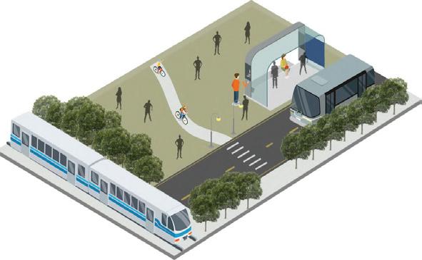
The stretch of clayton street is redesigned with bus lanes, cycle lanes and transit lanes. The existing nodes are improved . Elements like street furnishing and street art are added to the street
Sketch of the street furnishing


The formal tree planting from st. james boulevard continues in the west gate road. The pink lane connecting the central station will be designed with pedestrian and cycle lanes which connects through the green plaza to the west walls. The green plaza mereges with the landscape along the west walls.

Urban design and the use of design codes.
The project is response to the design codes of Lower ousburn by Newcastle city council. The transformation of Ouseburn from a neglected and overlooked backwater of the city to the thriving ‘alternative’ quarter of Newcastle.
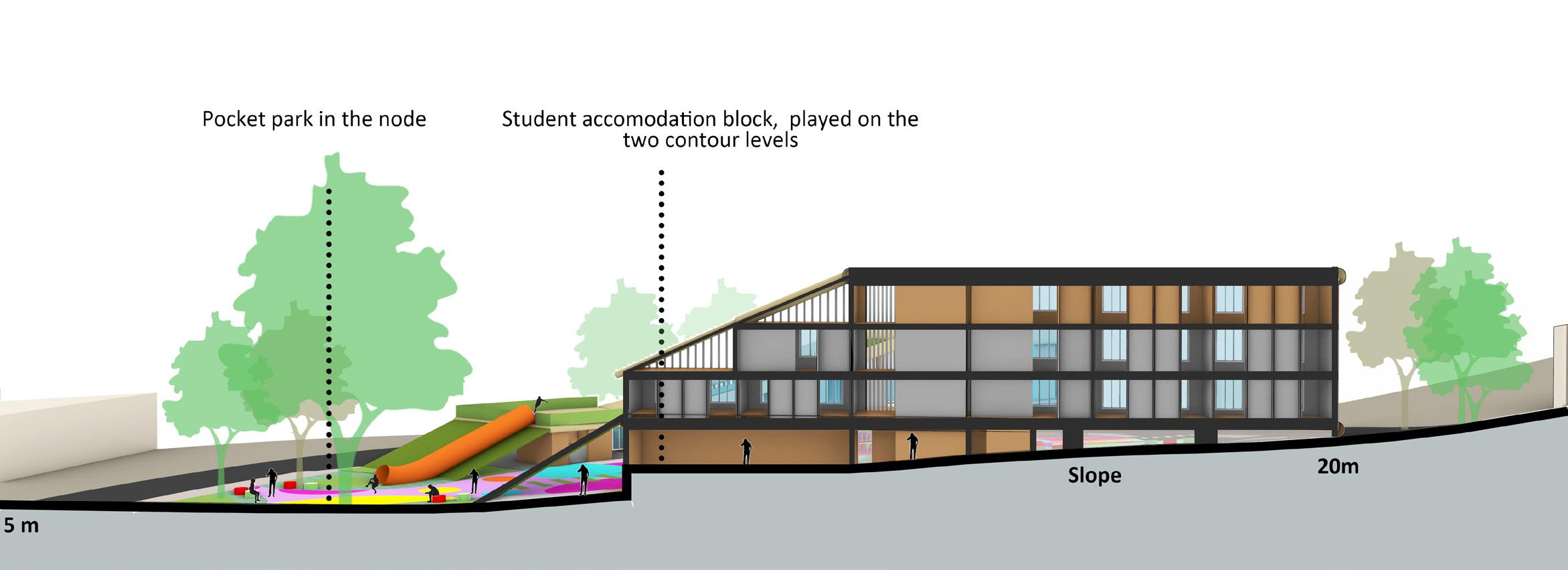
Explored various design elements that supports the design codes. The site was about 5 to 8 hectares where the development is made to attract young poeple to Ousburn and generate revenue to the site through student housing.
THEME OF THE PROJECT: CREATIVE ARTS CENTRE AND STUDENTS ACCOMODATION
This theme is about ensuring that Ouseburn is a great place to grow up and visit and where children have the chance to make the most of their talents and fulfil their potential.
AIM: Attract more children and young people from surrounding areas to the ValleyContribute to improving educational attainment in surrounding areas
To create a Playful site in ouseburn

ACADEMIC SEMESTER 2 WORK:
Project type: Academic work
Group contribution: Literature review and site analysis
Personal contribution: Precedent analysis, Final concept and design development.
Websites Used : Digi maps and Open street maps for analysis. Softwares Used: AutoCAD, SketchUp, Lumion , Photoshop, InDesign, Illustrator.
Master plan


Conceptual sketches

Highest contour-25m
Secondary access to the site
Lowest contour-5m

Access through the site connecting the neighbourhood Byker
Access points to the site Primary access Junction upgradation Slope towards the river
Base Conceptual Model (RHINO software)
One year of work experinece as Junior architect at DESIGN WORKS, CHENNAI, INDIA
Used softwares : Auto CAD, Sketch Up, 3D’s max, V-ray , Lumion, Microsoft powerpoint and excel.
One year of work experinece as Intern Architect in CHENNAI, INDIA
Used Softwares: Auto CAD, Sketch Up, Microsoft powerpoint and excel.

RESIDENTIAL DESIGN- Proposed residential apartment at Choolaimedu , Chennai, India.
117 sqm plot housing 3 residential units ( 2 bh and Duplex flats). The design also embraces the principles of minimalism, emphasizing clean lines, simplicity, and functionality. The interior spaces are thoughtfully organized to optimize flow and enhance usability. The use of neutral colors, sleek materials, and minimalist furniture further contributes to a sense of tranquility and modernity.

Project type: Professional works
Reference: vaishali@designworks.in - Senior architect at Design works, Chennai.


also embraces the principles of minimalism, emphasizing clean lines, simplicity, and functionality. Passive design strategies are employed to optimize energy efficiency.

The design aslso embraces the mixed style of traditional exterior facade and modern interiors, emphasizing the elements like clean lines, simplicity and functionality


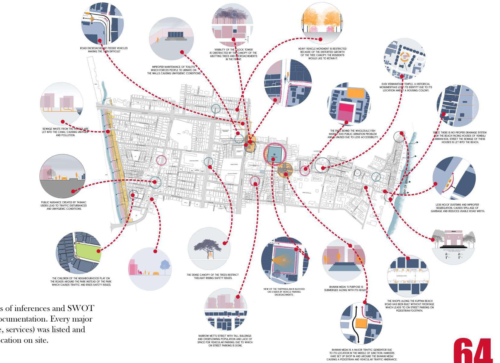
The objective of this project is to comprehensively document Thiruvanmaiyur, a substantial residential neighborhood located in Chennai, India. Additionally, the project seeks to formulate a design proposal that enhances the community’s social fabric, ultimately transforming Thiruvanmaiyur into an exemplary Chennai suburb.
Documentation, being major part of the Urban deisgn and the starting point for the process of analysis was done in depth and with extensive care in the design studio. The whole study stretch was divided and documentation of collected data was done under different aspects like social, built form, traffic, history and many more.

Project type: Undergrad Academic work
Group contribution: Literature review, site area documentation and site analysis, Framing of vision
Personal contribution: Final design development.
Websites Used : Open street maps for analysis.
Softwares Used: AutoCAD, SketchUp, Lumion , Photoshop.


Five teams, each comprised of five individuals, actively participated in the comprehensive documentation of the specified area. We conducted meticulous analysis involved in-depth examinations of every street within the area, conducted at various times of the day. The scrutiny covered multiple facets, including but not limited to daylighting conditions, pedestrian footfall, vehicular traffic, urban ecology and overall movement dynamics. This methodical approach was undertaken to gather a holistic understanding of the diverse aspects influencing the urban environment.


I possess strong sketching abilities and a deep passion for creating portraits. During my second year of the B.Arch program, I had the privilege of leading the Visual Sketching team, and our efforts were recognized as the best in the field. Some of my works were published in the University magazine.

during Rural area documentation semester during B.Arch

Recognised for taking part in NASA ZONAL COMPETITION- ( Sustainable techniques suitable for coastal fishermen communitites in south India)


the best fashion designer during the

Top ranked the architecture school during the year 20182019


