
VIVIAN MONTEIRO MALTA
STAYING & FOLLOWING AS SOURCES OF KNOWLEDGE of PUBLIC LIFE & URBAN RHYTHMS
Urban Studies Research - M.Sc. THESIS - 4CITIES
Softwares: Photoshop, InDesign, Word, PowerPoint
Public Space Design - B.Arch. THESIS - UFES
Softwares: Photoshop, InDesign, AutoCAD, SketchUp
EXPLORING THE BORDER BUSHWICK ELEMENTARY SCHOOL
Institutional Building Design - NYIT
Softwares: Photoshop, AutoCAD, Revit
Metropolitan Approach Proposal - Workshop
Softwares: Photoshop, IIllustrator, PowerPoint
Social Housing - Architectural Competition
Softwares: Photoshop, AutoCAD, SketchUp
CONTENT
01 02 03 04 05
LEAVES ON THE EDGE PAISSANDÚ RESIDENCE
STAYING AND FOLLOWING
AS SOURCES OF KNOWLEDGE OF PUBLIC LIFE & URBAN RHYTHMS
TYPE: Urban Research
LOCATION: Vienna, AT & Copenhagen, DK
SUPERVISOR: Henrik Reeh (UCPH)
YEAR: 2021
LINK:
For complete workhttps://www.4cities.eu/master-thesis/
As an architect and urbanist, it is inherent to conceive and design urban spaces. In the training process, we are taught to draw plans and abstract representations which are immobile, stable, looking at the city as an object, overstressing function and layout. Whereas, in reality, city spaces are lived spaces. Thus, when we work on a project or manage cities, we should think of this mobile dimension of city life. But how to do it? It is easily said, but it is much more challenging to integrate it into methodologies that allow us to design and
extractknowledge,whichiswhat thisworkattemptstodo.
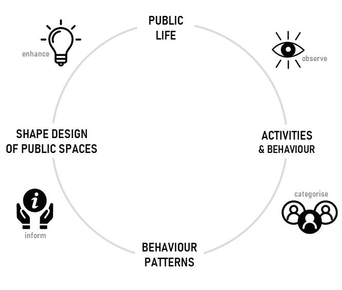
Istartbyexploringtwomethods with different points of view on howtostudypubliclifeinpublic spaces. Furthermore, public life is conceived not momentary but repetitive and cyclic, thus related to the concept of urban rhythms and rhythmanalysis (from Lefebvre), used here as a lens to discuss my findings. By doing so, I gained insight into new ways to study public life and to assist our understanding of city rhythms, to integrate this knowledge into further research andplanningapproaches.
1
O1
RESEARCH QUESTION & OBJECTIVE
Howmaythestudyofpubliclife inpublicspacesbytwomethods – stayingandobserving, walking andfollowing – inform a sense ofurbanrhythms?
• To explore two methods in their point of view to study publiclifeinpublicspaces.
• To discuss how they inform a senseofurbanrhythms.
• To provide an empirical exploration of the theoretical framework given by Lefebvre’s rhythmanalysisconcept.
APPROACH
Thisworkadoptsaphenomenological methodology with the assistance of two methods and case studies in Vienna and Copenhagen.
2
VIENNA
COPENHAGEN
KONGENS HAVE SCENE
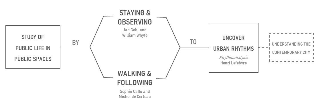
STUDY OF PUBLIC LIFE IN PUBLIC SPACES
UNDERSTANDING THE CONTEMPORARY CITY
Jan Gehl and William Whyte
Sophie Calle and Michel de Certeau
Rhythmanalysis Henri Lefebvre
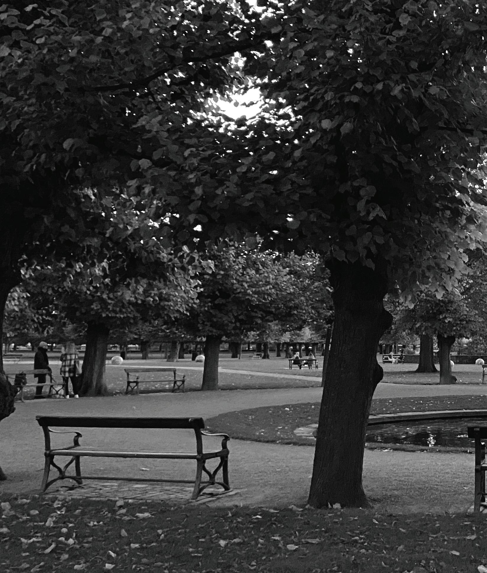
STAYING & OBSERVING IN VIENNA
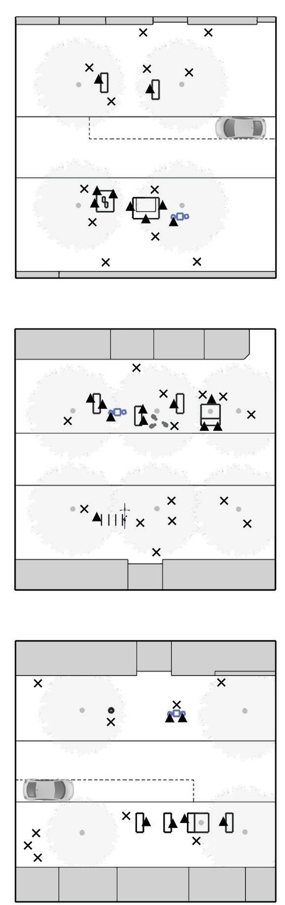
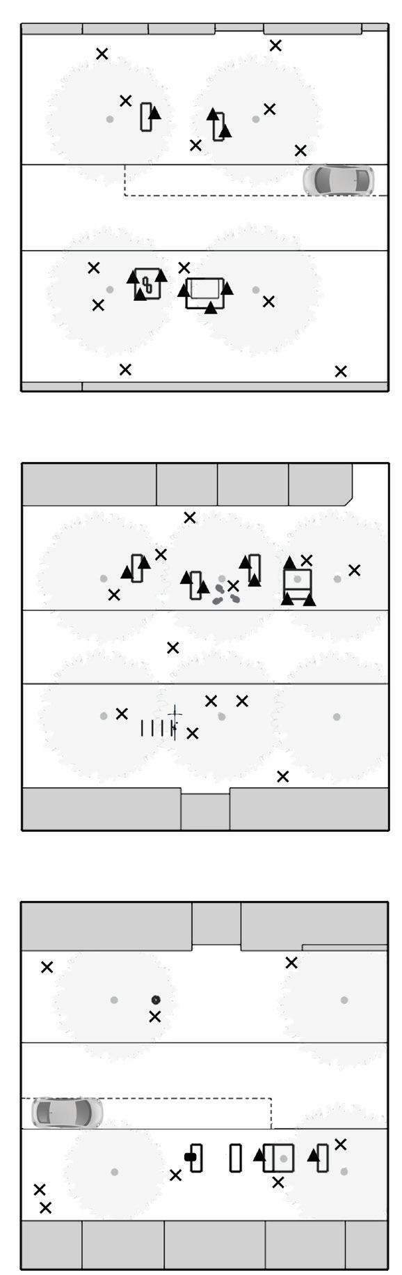
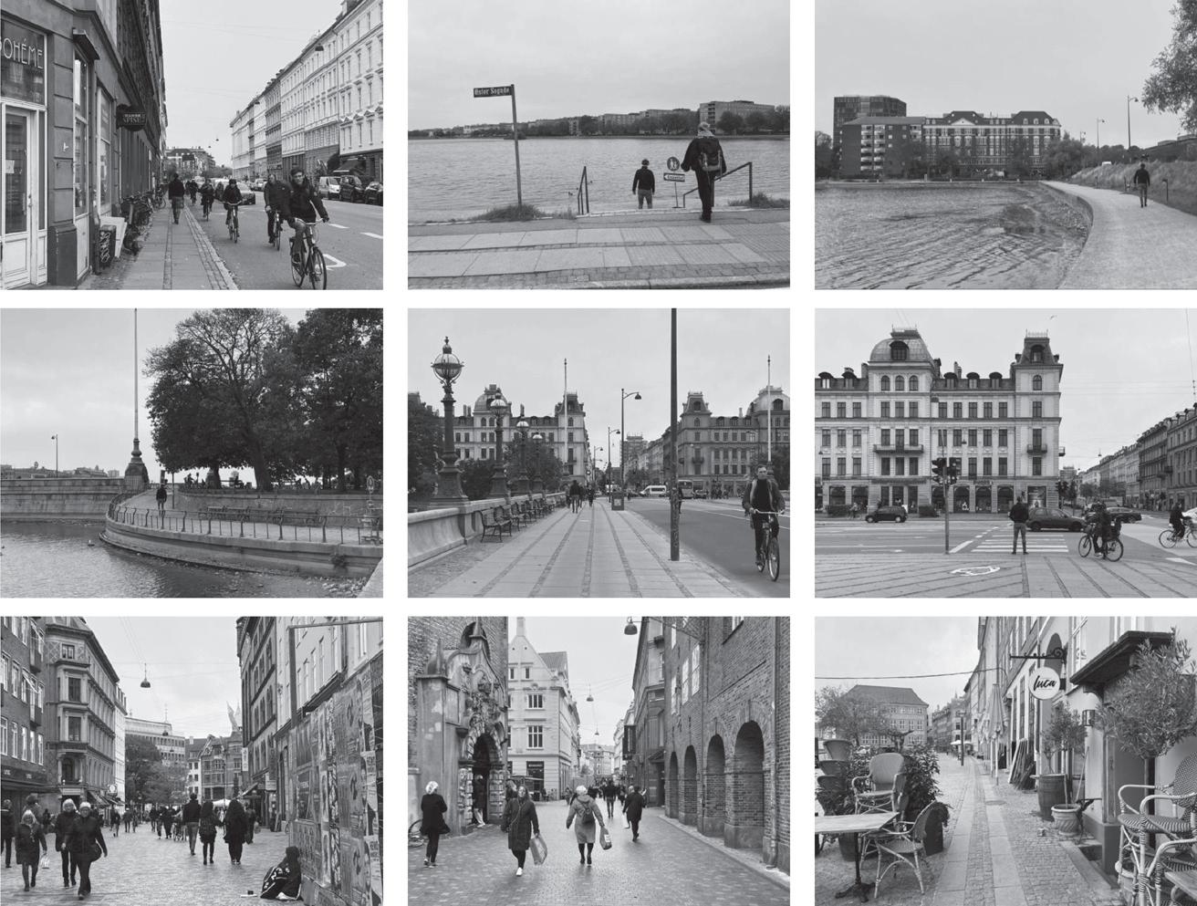
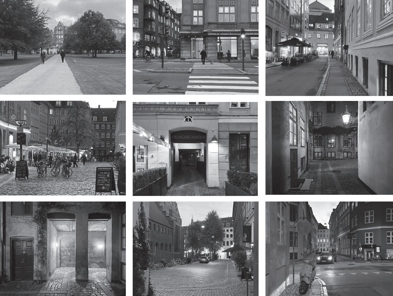
The first method is based on Jan Gehl and William Whyte approach to study, register and illustrate urban life. These authors developed public life studies as an interdisciplinary field to inform urban design. Both have conducted systematic research on people in public spaces(focusingonpedestrians); have looked for behaviour patterns, quantifiable data on public life and spatial features conditioning those; and have drawn specific remarks from general observations to inform urbanplanninganddesign.
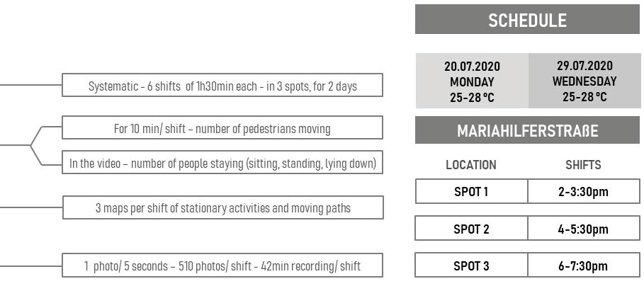
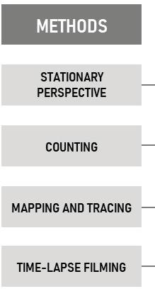
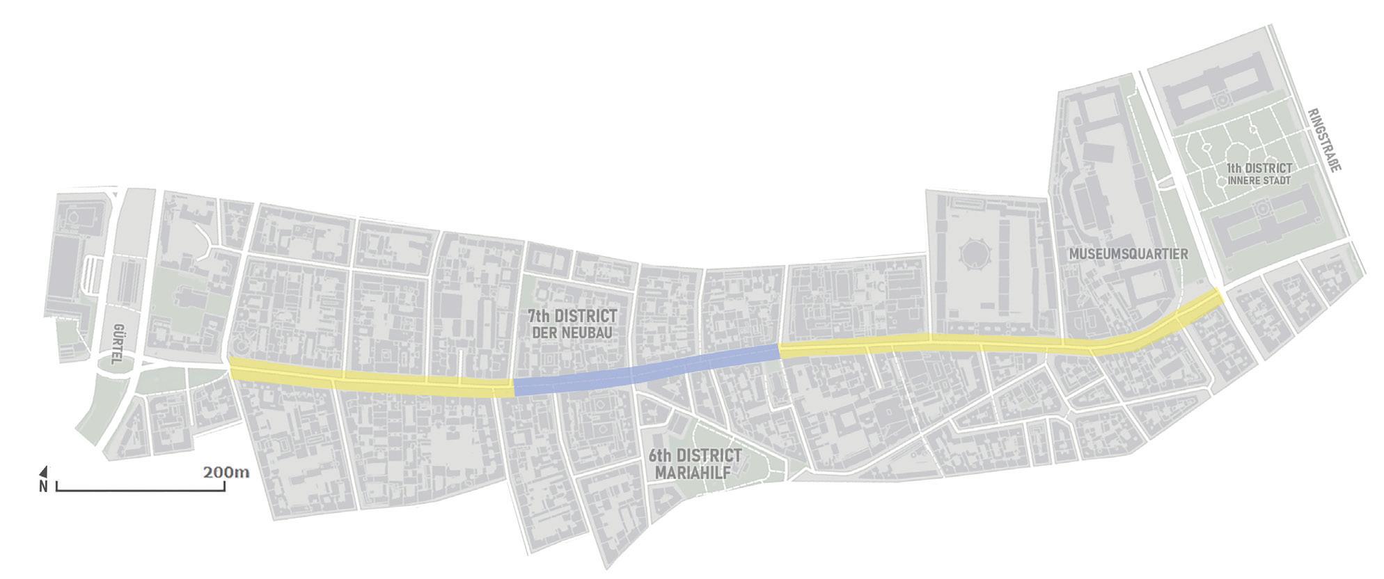
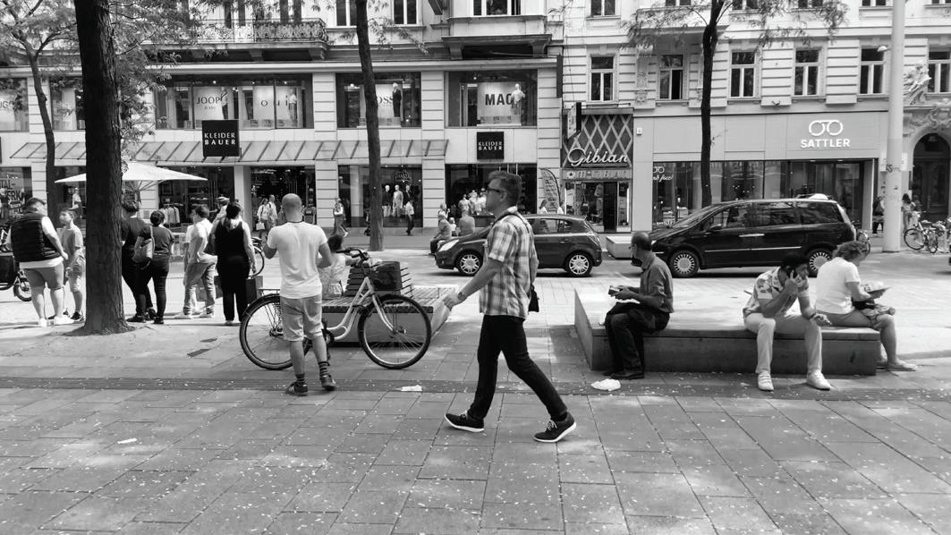
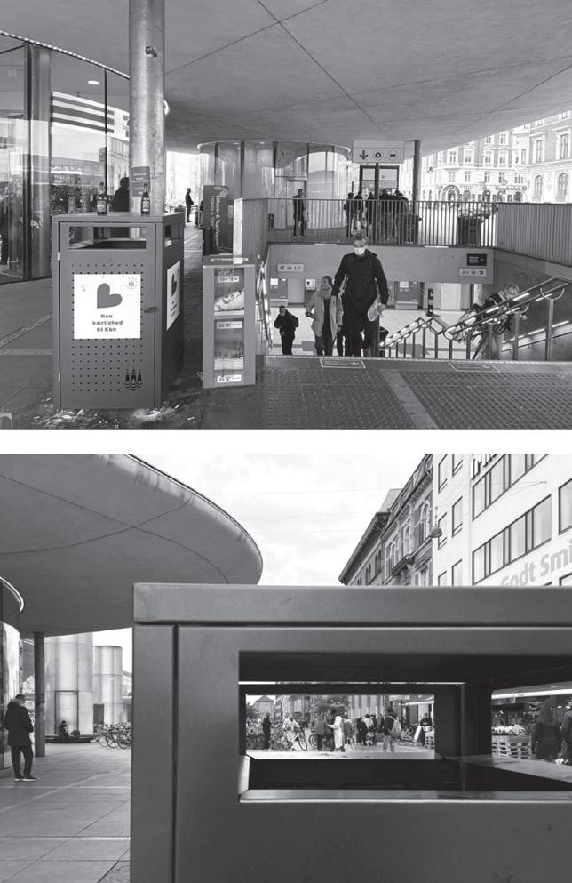
Based on their work, I used direct observation from a stationary perspective as the core to study people in Mariahilferstraße, which is a well-known shopping street in Vienna with a shared traffic concept. While systematically observing I also recorded time-lapse videos that were combined to gather other data as the counting of pedestrians moving and staying, tracing of their movements and mapping of their stationary activities in order to find patterns of city life in Mariahilferstraße.
LOCATION
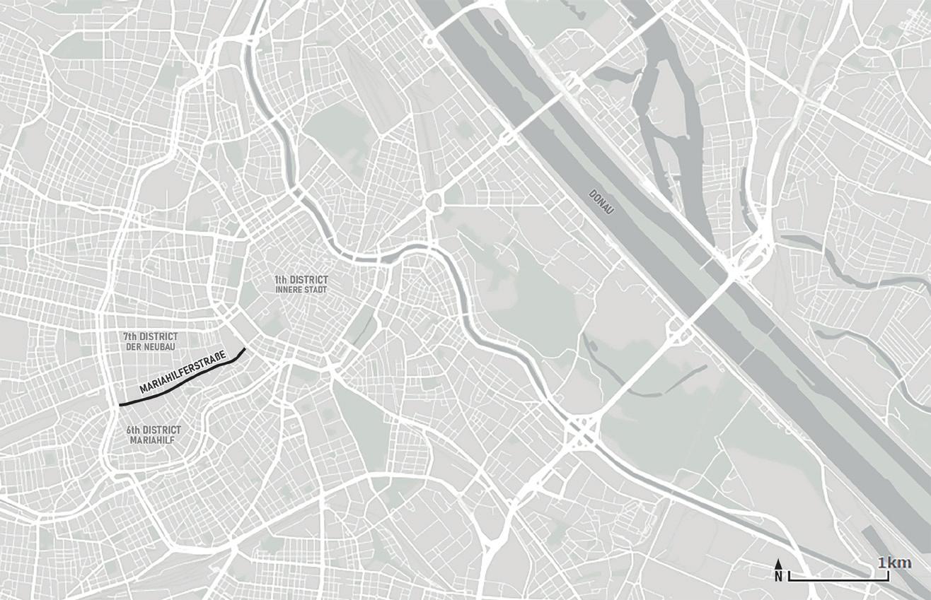
Mariahilferstraße is 1,6km-long street, shared by pedestrians, cyclists, and drivers. Located at the border between the 6th (Mariahilf) and 7th (Neubau) districts of Vienna, it goes from the Museums Quartier to the Gürtel, connecting the centre to its newer neighbourhoods. Locals, visitors, and tourists use the area for shopping, walking, accessing the metro, and other activities. Also, the street is considered a linear green and openspacebytheCity.
3
observe categorise inform enhance
DAY PROGRESSION IN MARIAHILFERSTRAßE
The perceived number of people in Mariahilferstraße changes with thedayandisstronglyinfluenced by the shops opening and closing hours. In summer, an ordinary daygoesaccordingly:
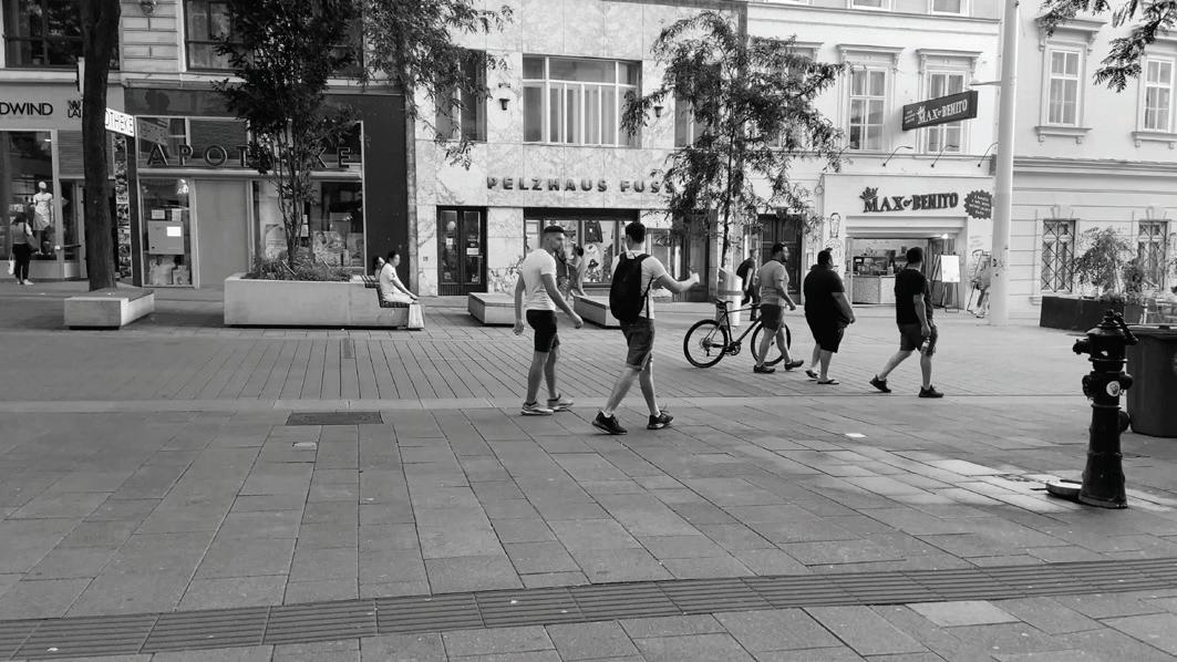
Before10a.m. Most people walk to go to work, school, to take the metro. A few also walk with their dogs or drink coffee. Some people sit on spots under thesun,andtrucksdelivergoods. 10a.m.to2p.m. As the shops open, more people come to use the street and occupy the benches. It is noticeable the presence of elders among user groups.
2p.m.to7p.m. The busiest timein Mariahilferstraße.Alotof people are shopping, sitting, and walking. At this time, the plaza feeling that qualifies the street as more than a transient space is noticeable. Primarily seen are youngpeopleandadults.
7p.m.to11p.m. Shops close around 7 p.m., progressively fewer people transit in the street, but still, many are sitting and enjoying the sunset in a more serene scene than earlier. Young adults are mostly seen among usergroups.
4
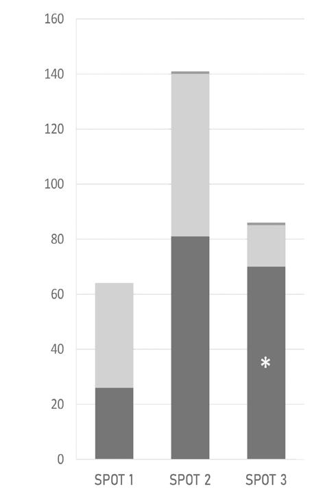
SPOT 1 - located in the western shared zone
SPOT 2 - located in the pedestrian zone
SPOT 3 - located in the eastern shared zone
THE FLUX OF PEOPLE
- GENERAL PATTERNS OF PEOPLE MOVING

Within Mariahilferstraße the movement patterns change and are mostly affected by the traffic concept. However, the crowds’ number, noises, and standing differences over the three spots observed were combined with the static spatial divisions to produce various spatial rhythms along the street. People were affected by the traffic concept but also affected the spatial
rhythms by their movements along the street. This reveals the understanding of space as fluid even when on the same publicplace.
The observed staying activities also suggest many urban rhythms taking place at the same time. In a way, what Gehl subdivides as necessary, optional and social activities (Gehl, 2011) can be associated
with the understanding of rhythms. Much of the necessary activities in public spaces are related to linear rhythms of socially imposed structures. For example, in Mariahilferstraße, movements of people going to school or work, arriving in the shops, or queueing are associated with Viennese work schedules. While many optional activities in the street
5
walking471 62 45 670 115 50 350 73 25 SPOT 1SPOT 2SPOT 3 biking other walking466 65 48 678 108 53 355 75 19 SPOT 1SPOT 2SPOT 3 biking other DAY
DAY
DAY
DAY
1
1
2 SPOT 2 SPOT 1 SPOT 3
2
A GOOD STREET TO STAY
- GENERAL PATTERNS OF PEOPLE STAYING


were related to cyclical rhythms, people sitting or standing for eating, drinking, or feeding a child have these activities connected to body rhythms of hunger, thirst or desire (Lefebvre,2004).
Staying and observing, as a behaviourist approach based on Gehl and Whyte work, offers valuable tools to findings patterns of movement and
staying activities. However, observations on the street demonstrated that the researcher is immersed and engaged in the surrounding environment before any analytical reflection about it. Also, this method restricted the research to visible actions, neglecting other senses and limiting the understanding of experiencingpubliclife.
Therefore, it still raised the wonder of how to account for people in public spaces. Specifically, howtoaccountfor theonesmovinginthestreet?
6
standing26 38 0 81 59 1 70 15 1 SPOT 1SPOT 2SPOT 3 sitting lying down standing42 49 0 96 49 0 90 26 0 SPOT 1SPOT 2SPOT 3 sitting lying down
down Added furniture DAY 1 DAY 1DAY 2
Lying
SPOT 2 SPOT 1 SPOT 3 DAY 2 Standing Sitting
* 2/3 of people standing in Spot 3 were costumers of a burrito place
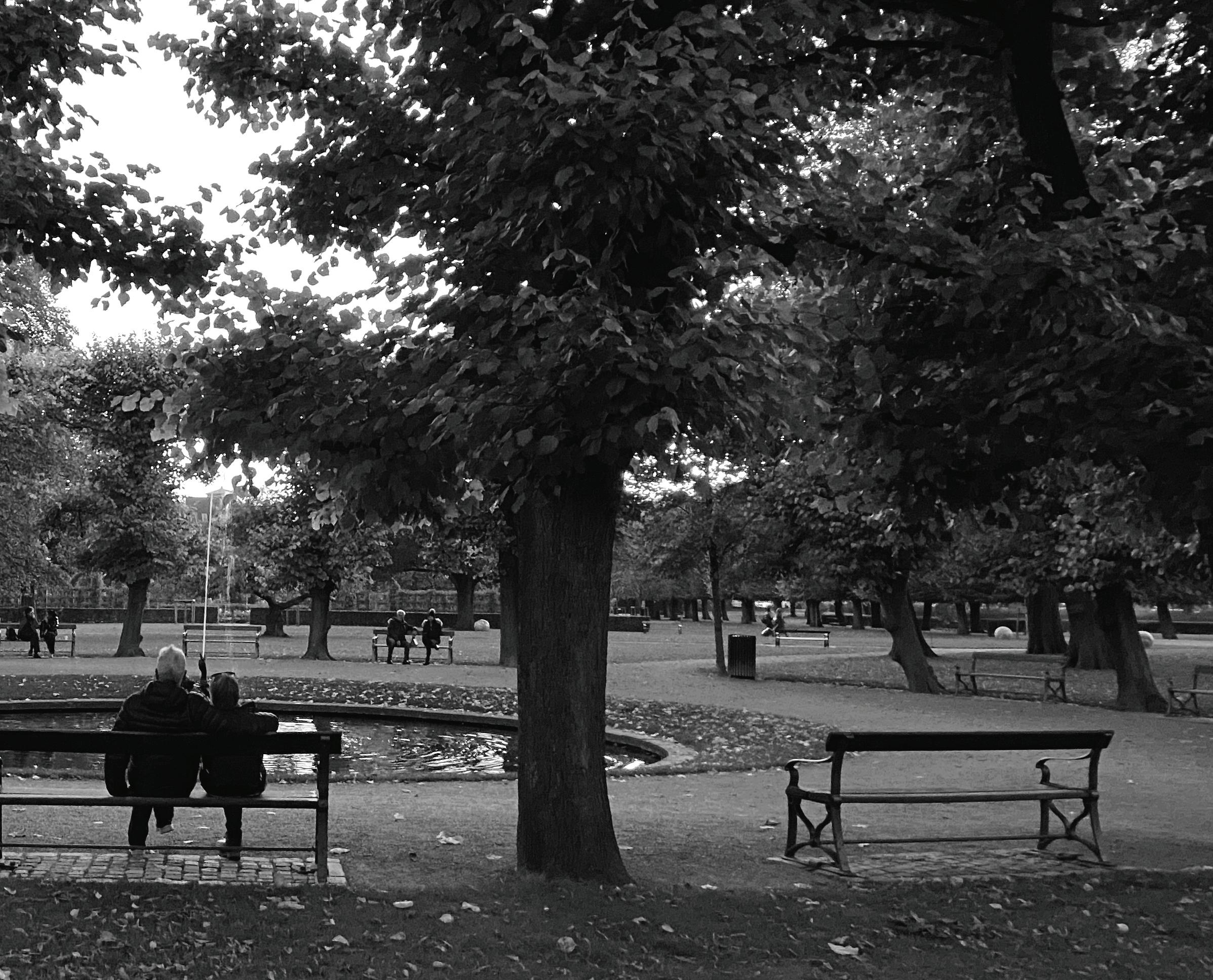
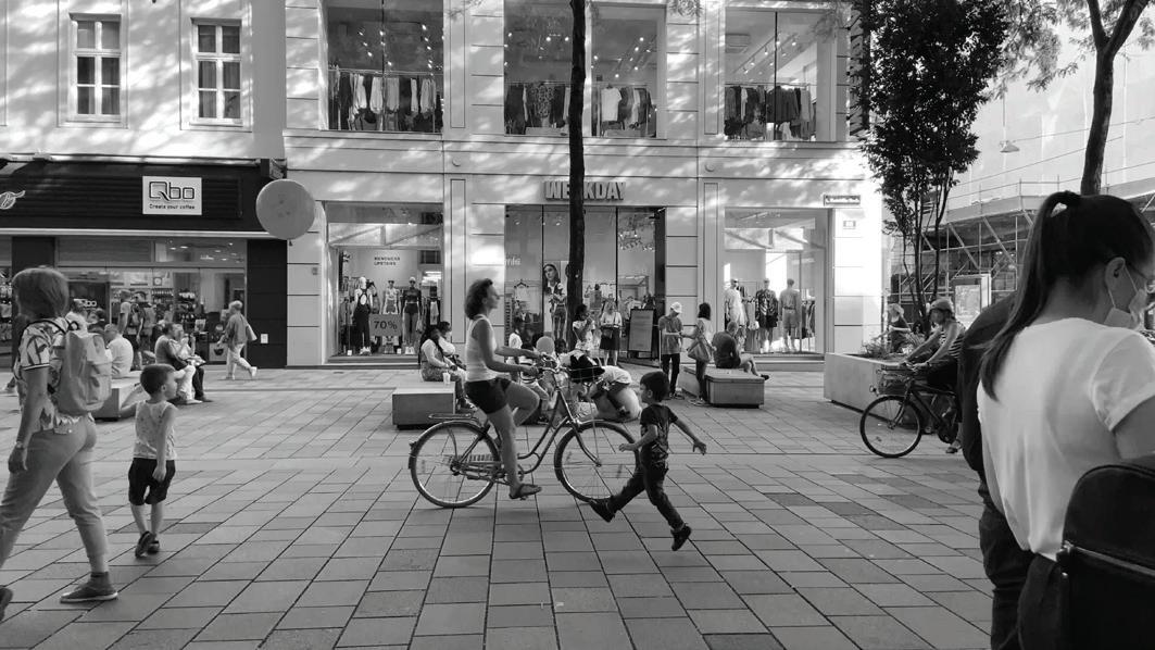
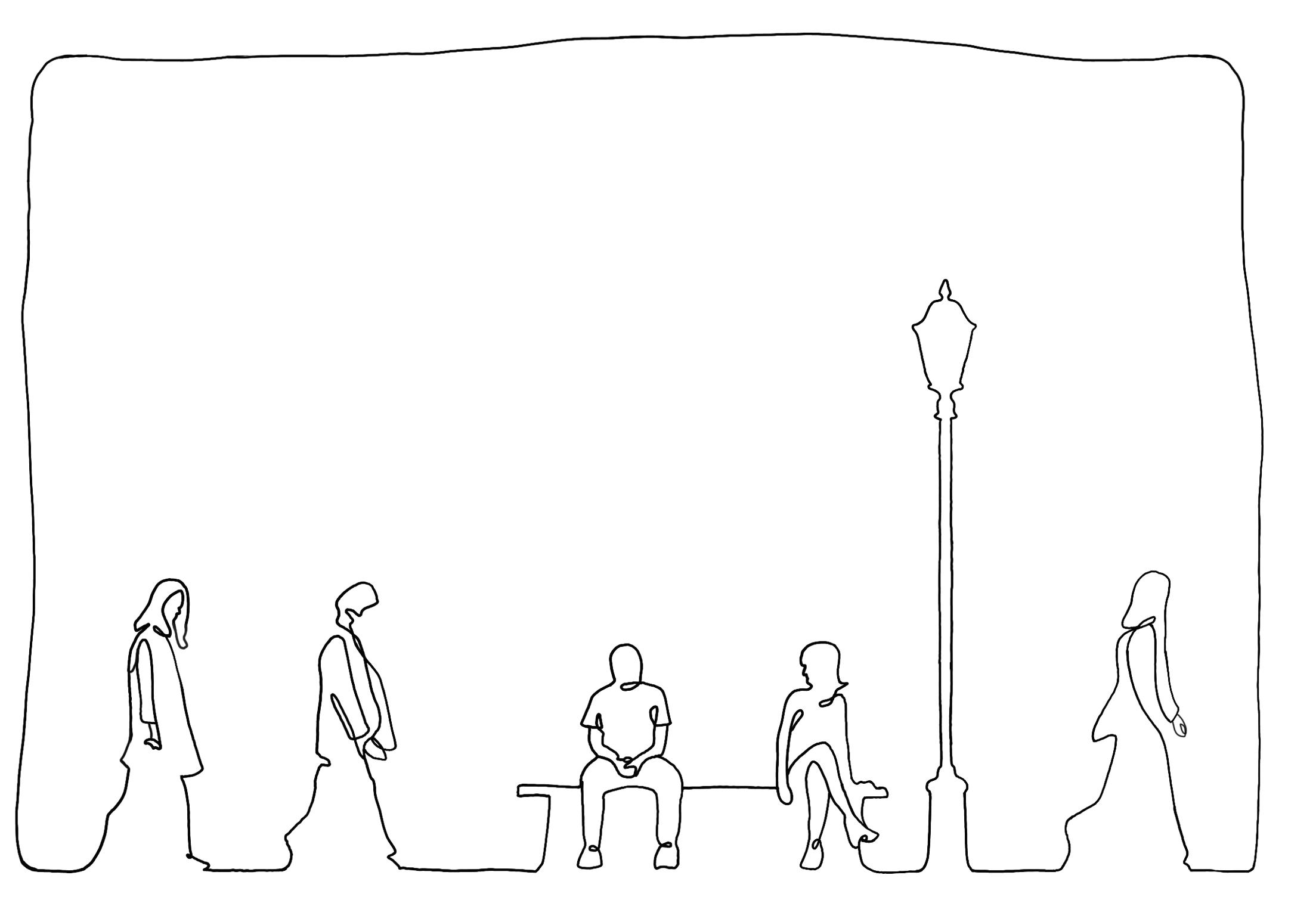
WALKING & FOLLOWING IN COPENHAGEN
The study in Vienna concluded with the need for new ways to look at city life, which led me to the methodology of walking and following, based on Calle and de Certeau approach to public life through movement and experience. Calle is a contemporary artist, a woman walking in Venice and following Henri B. In her work, she explores human life as an artistic project. De Certeau is a philosopher and writer that raisesawarenessfortheordinary
person walking in the city and practising the everyday life that is hardly grasped by planners, who are used to look at the city from above. Here combined, CalleanddeCerteauassisteach other’s work. De Certeau offers walking as a public life activity, and Calle offers following as a way to understand this practice and reveal everyday urban life. Here lies the novelty and relevanceofthismethodological partofthepresentresearch. Based on their work, I followed
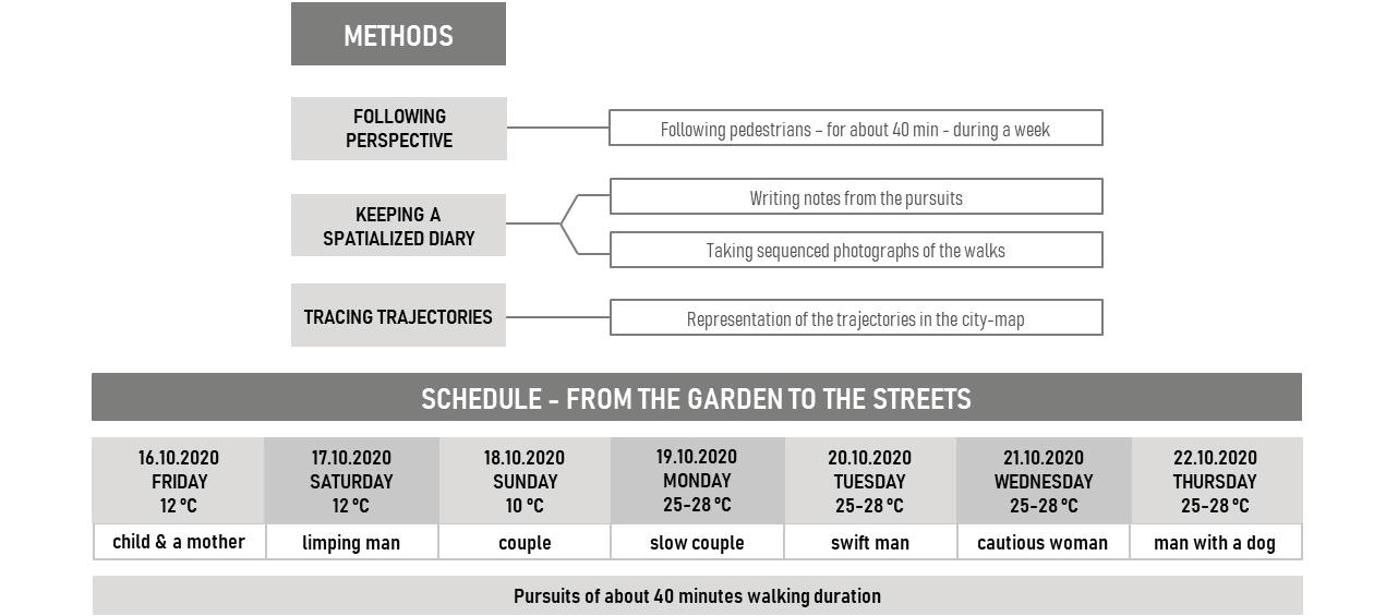
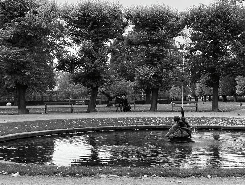
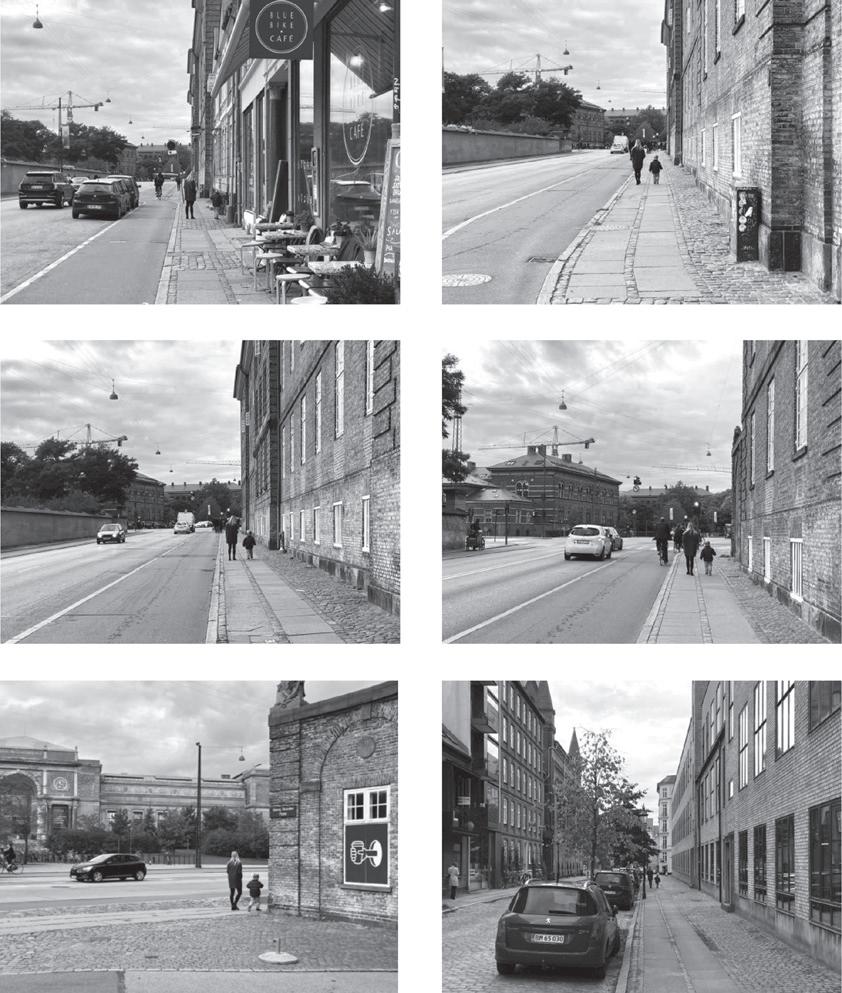
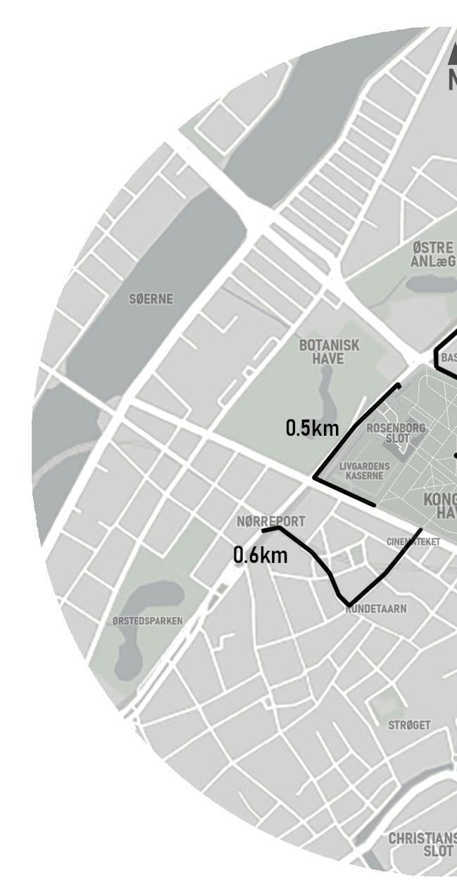
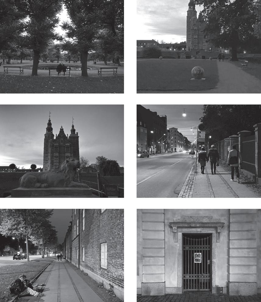
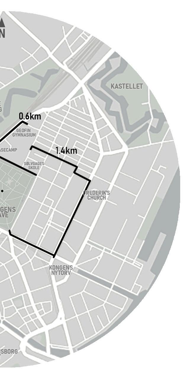
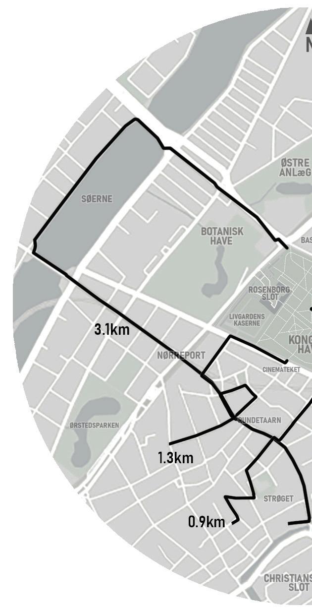
pedestrians for one week starting every day from the same point in the city, the fountain “The Boy on the Swan”,in KongensHave.While following, I kept a diary taking notes on people's movements, sequential photographs of their routes, and, lastly, traced the trajectories in maps that summarise the walk. Out of 15, 7 pursuits with similar duration were selected for comparison to register and reveal public life in Copenhagen.
LOCATION
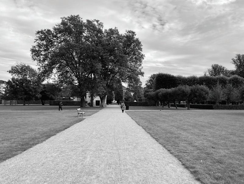
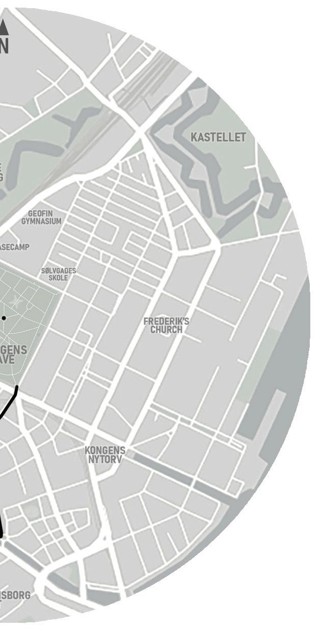
Kongens Have is a living cultural-historical open space of twelve hectares, located in the city centre, by the Rosenborg Castle. The park is surrounded byresidences,schoolsandother institutions, commercial areas, and other two city parks, the BotanicalGardenandthe Østre AnlægPark. Close to it is also located the busiest station of the city, NørreportStation. Making KongensHave one of the most importantparksinCopenhagen.
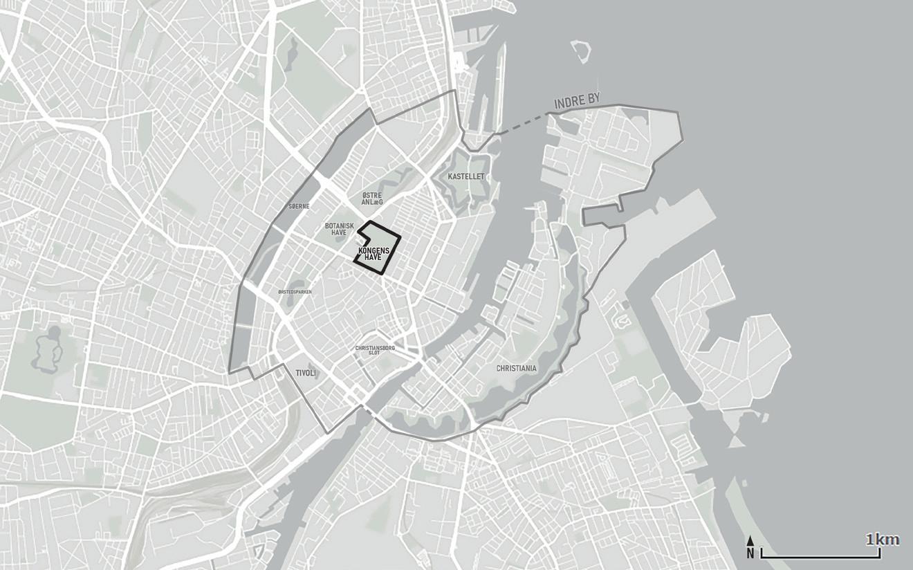
7
KONGENS HAVE
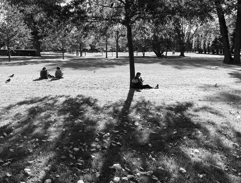
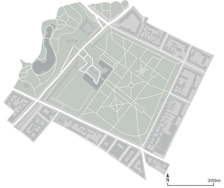
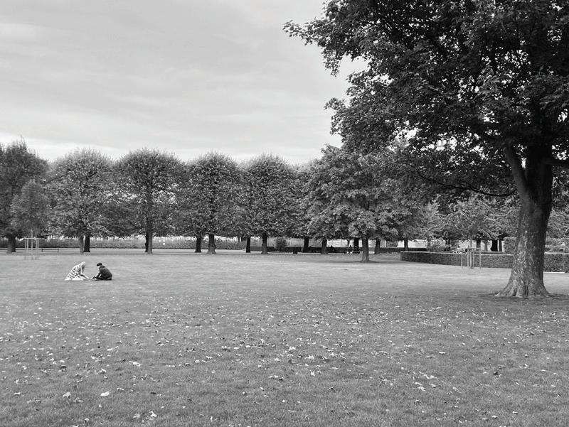
The King’s Garden was established in the early 17th century as Christian IV’s leisure and kitchen garden for his Rosenberg castle. In the 18th century, it was opened to the public and became one of the very first parks in the city. Over the centuries, the garden adapted to different times and uses, however keeping its character. Nowadays, Kongens Have has the importance of a city park, yet is also a central green area for the surrounding residents.Becauseofitslocation and design, it plays a very urban roleinthecity’severydaylife,by being daily used by pedestrians as a shortcut to access different areasofCopenhagen'scentre.
8
FOUNTAIN “THE BOY ON THE SWAN”
ROSENBORG SLOT
LIVGARDENS KASERNE
SEVEN PURSUITS
Friday. October16,2020–12°C.
5 p.m. The kid stops often. She points to the floor and the façades and says something to the woman that patiently agrees. As the floor changes from concrete slabs to cobblestones, the little girl also changes her walk. She seems to dance on the cobblestones. Her arms up to the shoulders and the feet on thetoes…
Saturday. October17,2020–12°C
3:30 p.m. A man, about 55 years old, leaves the Garden at Gothersgade exit, close to the Cinemateket. He crosses the street before me, but I observe while he is going in the direction of Landemærket. He limps while walking... He looks around himself as if he senses I amwatching…
9
A CHILD & A MOTHER
A LIMPING MAN
Monday. October19,2020–8°C.
6:30 p.m. They stop at the Rosenborg Castle and observe the lions. They stroll, the man carries the woman’s purse. He often stops to look at the surroundings, the castle, the parked busses, the gate of the garden. Ihavetobecarefulto notbecaught…
Sunday. October18,2020–10°C.
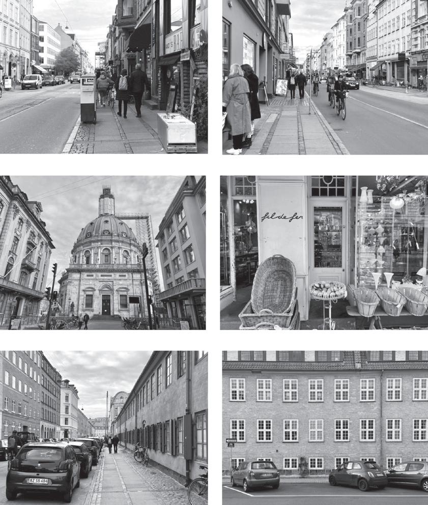
4:15 p.m. A couple in their 50s arewalking,holdinghands. The woman has a yellow backpack, and they walk harmonically together. Exit in the South corner, they go down walking Gothersgade In Kongens Nytorv, they first make it to the right but then decide to go left into the Store Kongensgade. They walk, looking at the windows, and the man takes a picture of the Marble Church Quickly,Ido thesame.
10
A COUPLE
A SLOW COUPLE
Tuesday. October20,2020–10°C.
11:20 a.m. A man, about 30 years old, passes through the Fountain... He is tall, and walks very fast… Ifollowatspeed. He wears headphones, looks pretty concentrated on his thoughts. He does not guess the way; neither looks to the sides. He walks surely. He knows where heisgoing. Whereishegoing?
Wednesday. October21,2020–12°C

1:30p.m.In Frederiksborggade, she stops at the corner, looks right and left, thinking about wheretogo.Sheturnsleft. She looks at the surroundings, thestreet,shopwindows, buildings, people. She does not takelongtoseeme. Itrytohide in my umbrella, but she gets suspicious.
11
A SWIFT MAN
A CAUTIOUS WOMAN
Thursday.
October22,2020–13°C
5:40 p.m. A man, in his 60s, is walking accompanied by a small dog. Iwonder...whoisleading theway,themanorthedog? Theyarefightingforleadership. On the sidewalk, the dog meets another dog, and they play together. The owners shortly smileateachotherandjustwait. Then, the battle continues. The man tries to keep walking while the dog tries to stop every five seconds. Eventually, the man givesupandstopsforamoment beforeresuming.
Walkingandfollowingobserved the disseminated person, where following double-layered walking and emphasized it as a spatial practice and way to experience the city. It displayed varietyofwalkingforms,walking as more than just moving from A to B and the pedestrian as more than a unit. In the observations, pedestrians had perception and impact of and
in space very particular to their movements, body and everyday life rhythms. Also, the diaries integrated time and space in a spatial narrative for the description of the experience and analysis of public life. Lastly, this perspective focused on the body with all senses, using my body rhythm to describe the movements of otherpedestrians.
12
A MAN WITH A DOG
RHYTHMANALYSIS
Lefebvre says that “everywhere where there is interaction between a place, a time and an expenditure of energy, there is rhythm”, starting his discussion towards the rhythmanalysis as a way to consider time and space together, in the understanding ofeverydaycitylife.
To this, Lefebvre classifies rhythms as either cyclical or linear. Cyclical rhythms are natural, biological, and bodily, such as day and night, seasons, hours and months, movements of becoming. And linear rhythms come from human and social practices, structures, schedules,movementsofwork. Lefebvrefocusesonthe bodyas
thepointofcontactwheresocial (linear) and biological (cyclical) rhythmscoexist.Hesuggeststhe rhythmanalyst “does not simply analyse the body as a subject, but uses the body as the first point of analysis, the tool for subsequentinvestigations.”

Lastly, Lefebvre argues that rhythms are in constant interrelation, named Polyrhythmia. And this relations can be harmonic (Eurhythmia) or disruptive(Arrhythmia). Thus, these are the basic concepts of rhythmanalysis used to discuss and integrate the analysis of urban life in this research.
URBAN RHYTHMS - DISCUSSION
Public life and urban rhythms are interrelated subjects as the movements of people, interactions, and rest in relation to urban spaces, architecture and cycles of the day, seasons and years merge into rhythms that give city spaces temporal distinctiveness. By staying and observing, walking and following, urban rhythms were observed in Vienna and Copenhagen, here categorized by spatial, social and body rhythms.
SPATIAL & SOCIAL RHYTHMS
Staying and observing kept one public space constant in analysis, where it was possible to observe static and dynamic rhythms associated with social rhythms.Thedayprogressionin thestreetisonestronglymarked by the social rhythms of shop hours. Also, this perspective found spatial patterns affected
by traffic design and accounted for masses of people moving and staying, which indicate dynamic spatial rhythms that gives Mariahilferstraße much of itsatmosphereandtemporality. In walkingandfollowing, space appeared more abstract, not attached to one static locality, but taking on sequentiality to understand movement through the city (from the garden to the streets, and other spaces in Copenhagen). Also, it made evident how everyday life walks – coming back from school, going to work – are still ways of experiencing the city and living publiclife.
BODY RHYTHMS

In staying and observing, the people’s behaviours of stopping to rest or to eat demonstrated their body rhythms in Mariahilferstraße. This perspective adopted an
objective view and helped to produce tangible data on people’s moving and staying activities. However, it presented limitations to dealing with data that cannot be quantified or seen through behaviour watching,namelytheexperience ofmovinginpublicspaces. Walkingandfollowing kept the body constant in the analysis while time and space were passing.Itdemonstratedwalking as a body and spatial rhythm, and the pedestrians' diversity of body rhythms in movement. Also, this perspective allowed the researcher to use the own body as a metronome in the analysis of public life. This method presents limitations to the generalisability of results, but the following exploration gave new insights into the relationship of public life, moving in the city and urban rhythms.
13
THE BODY CYCLICAL RHYTHMS LINEAR RHYTHMS
CONCLUSION & APPLICATION
The people walking and staying in Mariahilferstraße and KongensHave are part of the perception and memory of those spaces as much as architecturalrhythmsare.Asfor location-specific, urban rhythms characterise spaces that are perceived by physical elements and also by dynamic rhythms associated with social practices and the body. These together are part of building the image of public spaces in the city. In this way, urban rhythms both describe and impact how we engage with and live in urban spaces.
The first perspective offered an objective view over public life, a data that is tangible and easier to operationalise, but reinforced the question of how to account for the experience of moving through space. Then, the secondpointofviewofferedthe experience as a way of studying public life, which was, indeed, closer to the one of living in publicspaces.
Concerning urban design and planning, this research suggests the exploration of how spatial and social rhythms interrelate in the use of public spaces, meaningthatthedecisiontostay
inpublicspacesisinfluencedby urban design but also by linear rhythms of work schedules and everyday life activities. This understanding can assist the interdisciplinary planning of the city,connectingspacesandlocal routines. Also, the research could be further developed to observe specific social groups moving in the city and to study public spaces in an integrated way, accounting for movement, rhythms and sequentiality to inform policies and urban design that aim to understand and improve contemporary cities.
14
EXPLORING THE BORDER
TYPE: Public Space - Urban Park
LOCATION: Vitória, ES - BR
SUPERVISOR: Homero Penteado (UFES)
YEAR: 2018
LINK:
For complete projecthttps://issuu.com/vivianmonteirom/ docs/tcc_vivian-070718
Borders tend to be detrimental tocitieswhen,inadditiontothe territorialdivision,theyevidence social inequalities among urban dwellers.
Thus,howcouldweusethese spaces of segregation as a potential connector between communities?
The objective of this work is to explore a border area between four neighbourhoods (Andorinhas, Santa Luiza, Pontal de Camburi and Goiabeiras)inthecityofVitoria - BR, by designing a connecting public space to enhance the interaction among different socialgroupsoflocalresidents. By analysing the demographics ofsurroundingneighbourhoods, it is possible to formulate a hypothesis about the variety of people likely to use a given site. In this project, socioeconomic
15
O2
data from the Brazilian Institute of Geography and Statistics (IBGE 2010), and also on-site observations, map analysis and walking tours guided by local community leaders demonstrated the big diversity of residents in these four neighbourhoods.
They have substantial socioeconomic differences, but also a significant variety of race, age groups and gender, indicating the potential of the area to receive a public space used by a diversegroupofpeople.

CONCEPT
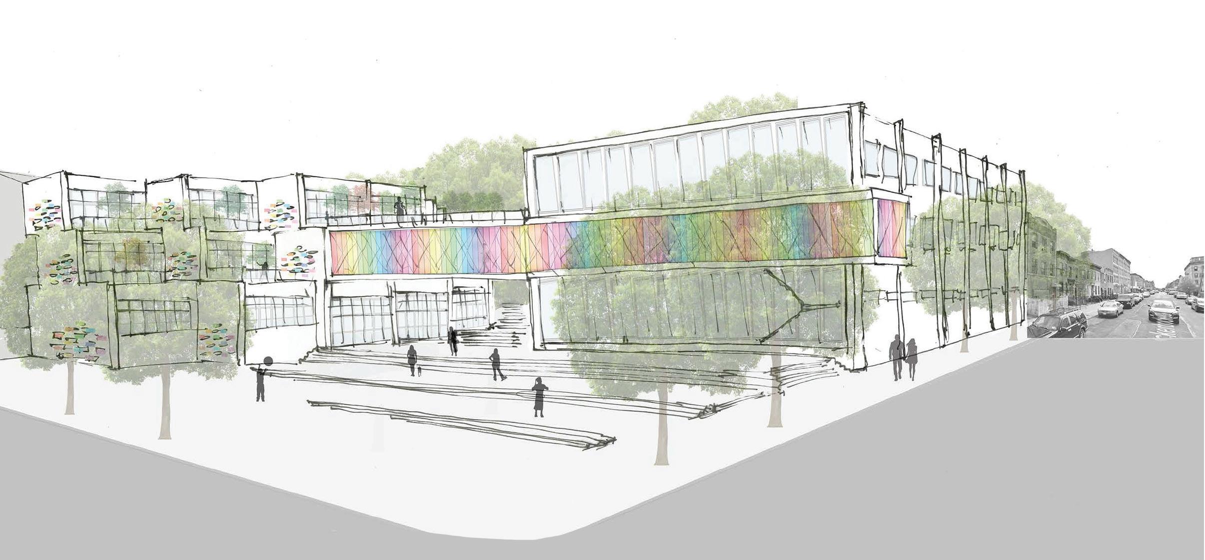
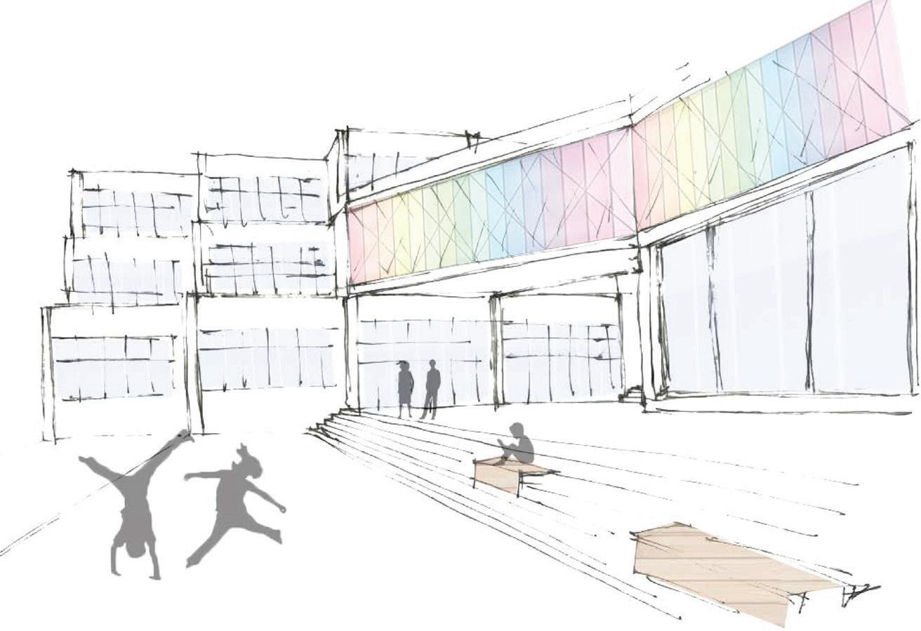
“Fromasegregatingbordertoa connectingpublicspace”-
To explore the border is to see theopportunitytobuildapublic space for community and social interactionsthatenhancesurban lifeandqualityoflifeinthecity.
16
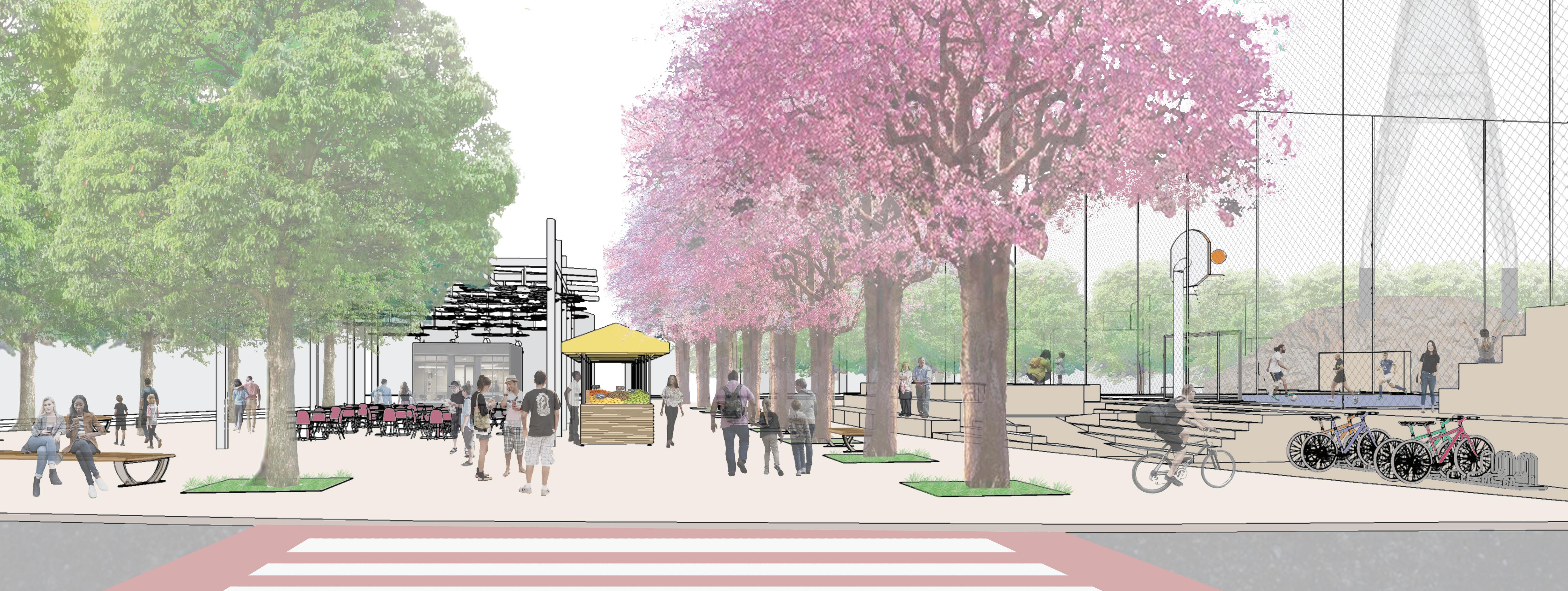
COFFEE AND MARKET PLAZA VIEW
The site is located in Vitoria, under the Passagem Bridge and facesthecanal.Itisdelimitedby local streets and metropolitan roads, suggesting the potential use of the area on a city scale. The surroundings are diverse in use, being mostly commercial in Santa Luiza and residential in Andorinhas and Pontal de Camburi. In Goiabeiras, the Federal University of Espirito Santo (UFES) brings many students, professors and youth to the area. Besides, the site has views of the canal, natural reserve and the Mestre Alvaro Mountain (a natural landmark). Lastly, the study suggests the lack and need for more public spacesintheregion.
Based on the analysis, it is proposed an urban park compiled of subspaces, a library and a student residence. The park and the library were developed at the preliminary study level and the residence was proposed only. This public space offers diverse activities thatareinterconnectedtoattract abigrangeofusers.
PARTI
Inthisdesign,thepartidevelops tocreateaccessandconnections between the neighbourhoods of Andorinhas and Santa Luiza, and between the land and the water.
The design process uses an orthogonal 1m x 1m grid to grasp the scale of the space. Together with arcs, circumferences and guidelines, the grid assists the composition and distribution of uses in the project.
17
LAND USE PROGRAM
Private
Inst.
18
THE PARK
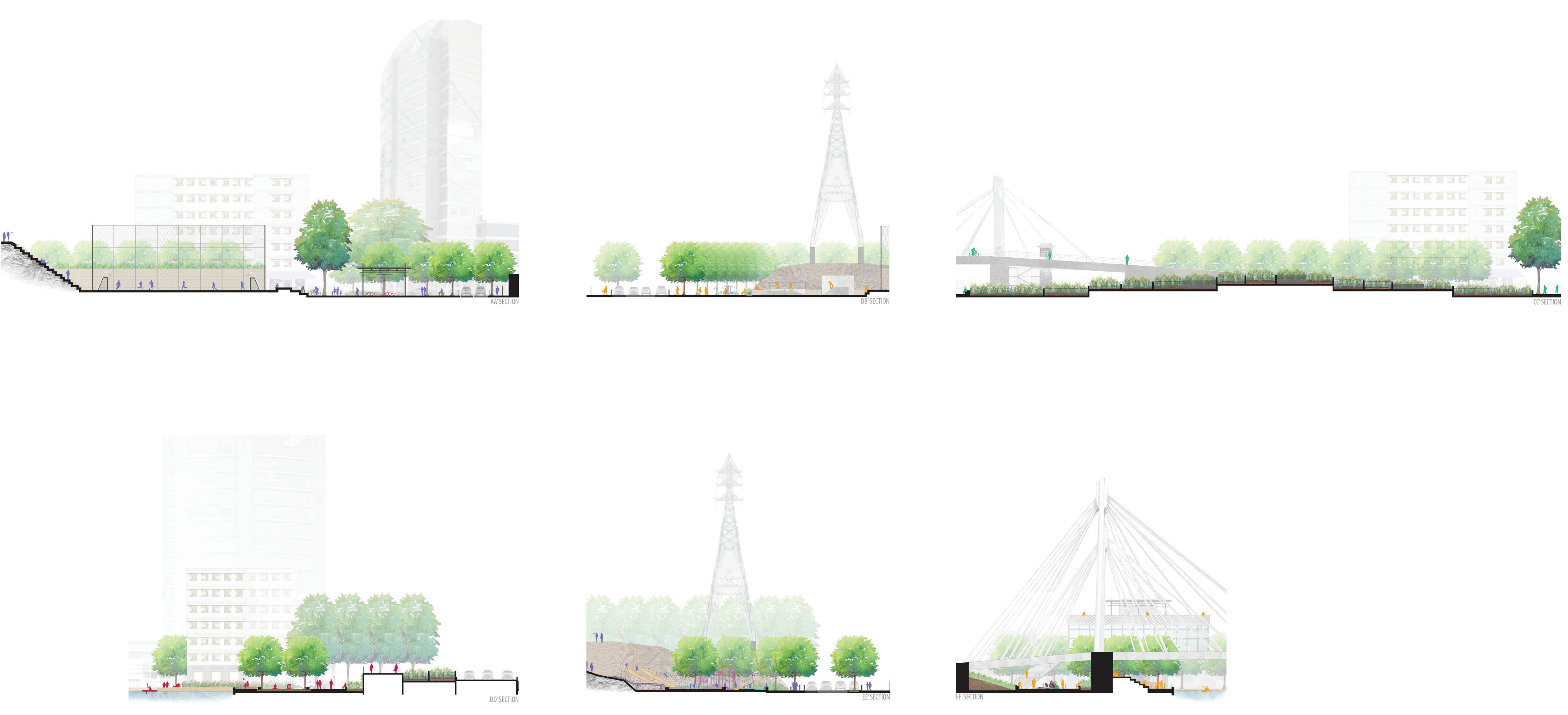
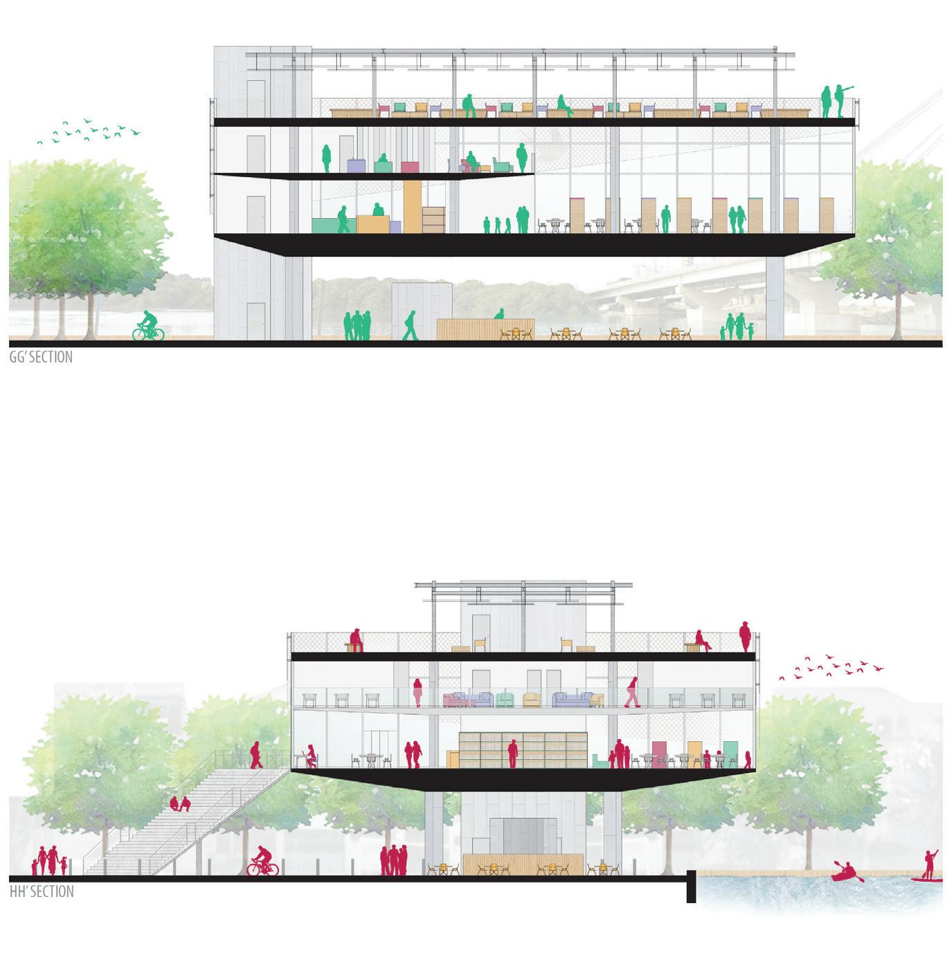
The design focuses on the pedestrian’s viewpoint to create visual and spatial connections by taking parti in existing elements. The rock formation, a natural barrier, is used both in the sports area, as steps and sitting space (see section AA’), and on the opposite side, in the playground, to support the slides(seesectionEE’).
The Sports court and the skate park are proposed to attract young people to the noisy areas of the park since these social groups tend to prefer bustling places (see section AA’). In this area is also proposed an outdoor Gym, game tables and chairs that can be used, for example, by elderly people to exercise and to watch the movement(seesectionBB’).
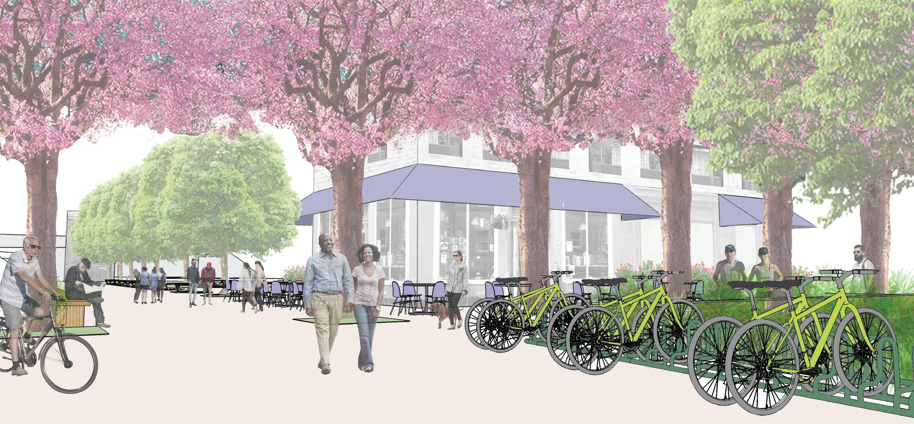
Near to this, the Coffee and Market Plaza is located where the local community of Andorinhasalreadyhasaweekly street market. This area holds the biggest flow of pedestrians in daily life context (see section AA’). The park spaces are subdividedtacticallyandvisually with different floor pavement andtreedemarcations.
In between the car and pedestrian bridges, the Rain Garden collects the pluvial water that drains from the bridges and treats it naturally before returning to the canal (see section CC’). This is also a practical and informative way to show citizens how plants can assist in the treatment of rainwater.
CC’SECTION
STUDENT PLAZA VIEW
Skate park Rain garden
DD’SECTION EE’SECTION

21
Sunbathing area MeadowGardenRain Garden
SlidesFountainBenches D. Clerio Falcao St.
Seeking to enhance connection with the surrounding nature, the design proposes a new border between the land and the water and the implantation of about 100 new trees in the park and adjacent streets. The trees should also work as a visual element to reinforce the connectingaxes.
Following, the Student Plaza surrounds the dorm building proposed next to the avenue of greater movement and another existing high-rise building. From the residence, the proximity to access the pedestrian bridge makes it easy for students to cross to the university. It is important to bring them to this areatoenhancetheirinteraction with the local community, to have more people using the park and the library daily and to create new pedestrians flows. Close to the residence is also proposedabikerentalpoint. The bridges that cross the site are surrounded by vegetation and benches to tactically and visually soften it from the pedestrian’s viewpoint. Next to it, the Meadow area receives the morning sun and provides a quiet space for contemplative activitiesinthepark(seesection DD’).
The Children’sArea is located near to the local street, it accounts with two playgrounds, one for 1 to 5-year-old children and another for 6 to 12-yearold children. This intends to meet different expectations of children of those ages, from quiet and exploring, to challenging and adventurous activities. Also, slides and climbing stones are designed on the rock and an interactive fountain connects the two playgrounds surrounded by a bench for caregivers to watch the children playing (see section EE’).
The MeetingPlazaislocatedon the border of Andorinhas and Santa Luiza. The installation of the Tulip sculpture by Jeff Koons – or something similar – is suggested. The colourful flowers made of reflective material should symbolise diversity, unity, and reflection of people in the space. Also, sitting steps facing the canal are designed for users to enjoy the view to the Mestre Alvaro Mountain (see section FF’). For this area is also proposed a staircase and elevator that give direct access from the pedestrianbridgetothepark.
22
LIBRARY PLAZA VIEW
SculptureStands
FF’SECTION
THE PARK LIBRARY
MAIN FLOOR PLAN GROUND FLOOR PLAN
MEZZANINE PLAN
The Park Library should be especially useful for the university students and many residents of Andorinhas to have access to computers, study areas, workshops and meeting rooms.
Foritsdesign,theparkdecisions were considered in the process,
TERRACE PLAN
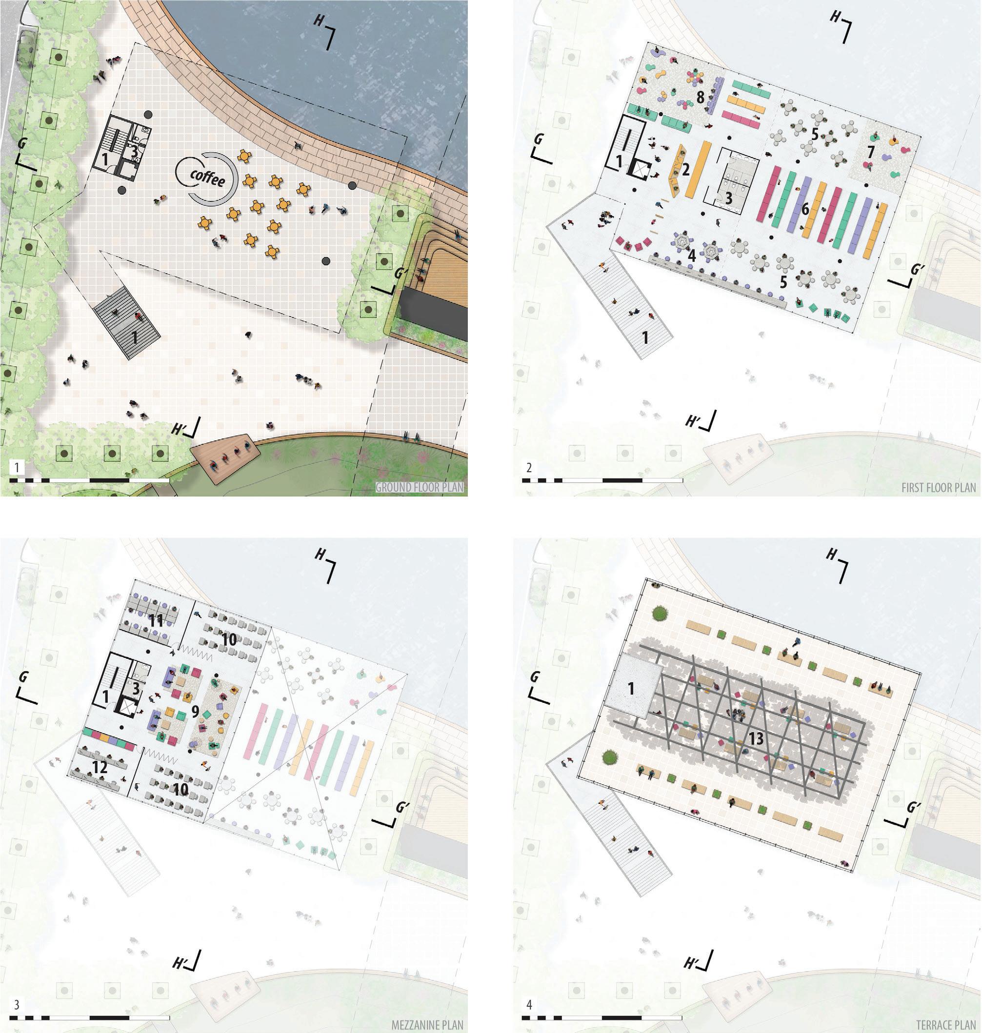
such as the main and secondary flows created, subspaces and views.
The open ground floor has a coffeebar and mobile furniture. Following,facingthestageinthe park,thestairstothelibrarycan also serve as a place to sit and watchpresentations.
23 Access Front desk Restroom Computers Studying Stacks Puff’s area
Children’s area Lounge Multifunctional Silent reading Staff area Terrace 1 2 3 4 5 6 7 8 9 10 11 12 13
The stairs and elevator lead to the main floor that holds the reception, computers, book stacks, children's and studying areas. On the next floor, the mezzanine overlooks the library, has a lounge area and two multipurpose rooms for classes and meetings. Lastly, the terrace on the top floor gives a continuation to the park on a higher level so that users can enjoythesurroundingviews.
The library building is partly overhanging the canal, crossing the border of land and water, and giving the user the sense to beonthewater.
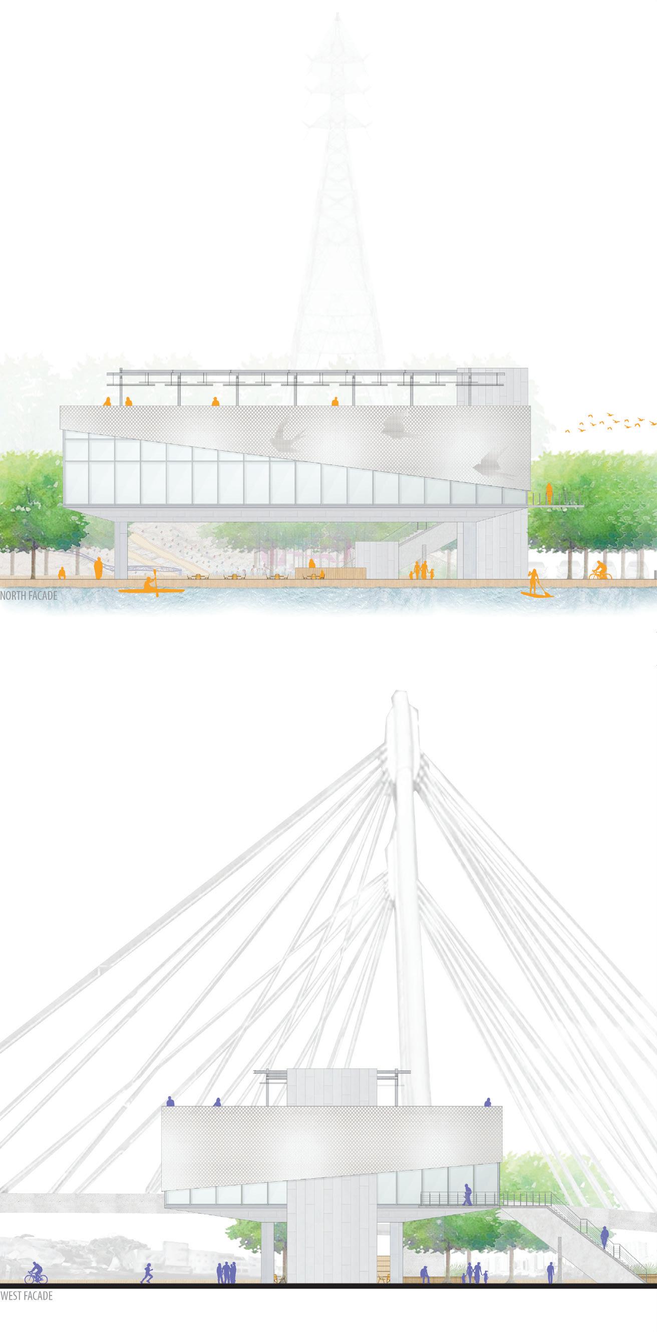

The façade is coated in glass, to allow the outside view, and wrapped with perforated metal panels that provide sun protection, thermal comfort, andventilatedfaçade.Theareas covered by the metal panels are placed according to the internal program and to the sun incidenceonthefaçades.
In the north façade, the figurative symbol of flying swallows is drawn on the metal in reference to the neighbourhood of Andorinhas (swallows in Portuguese) and in allusion to the power of knowledge to give wings (see NorthFaçade).
This project aimed to create a connecting public space that assists the diversity of users of the surrounding neighbourhoods to strengthen their community and to have a betterqualityoflife.
GG’SECTION
HH’SECTION
NORTH FACADE
WEST FACADE
Access
Coffeebar
Coffeebar
BUSHWICK ELEMENTARY SCHOOL
TYPE: Institutional Building
LOCATION: New York, NY - USA
SUPERVISOR: Matthias Altwicker (NYIT)
YEAR: 2015
Using the program of an elementary school, this project also offers the Bushwick neighbourhooda dynamicplace to meet and build a stronger community.
Thedemographicanalysisofthe areainBrooklynshowedittobe mainly composed of Hispanics from the Dominican Republic and Puerto Rico, African Americans and new dwellers that have been priced out from nearbyneighbourhoods.
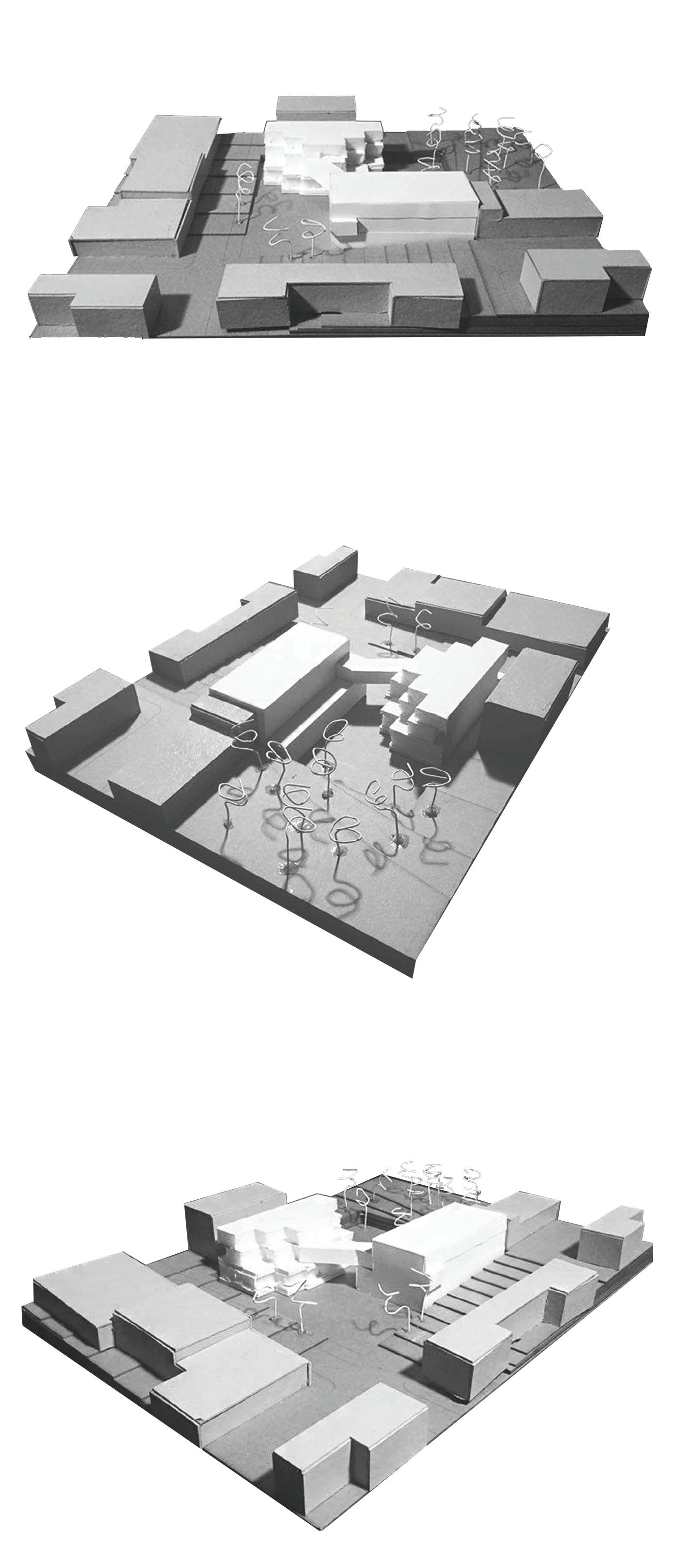
The school at the corner of Knickerbocker Ave. and Woodbine St. is adjoins the block with the Bushwick Playground Park and the
25 O3
Academy for Excellence Leadership High School. The area is already daily used by the local community. Therefore, the elementary school is proposed to enhance urban life and strengthen this community by offering new public spaces andmeetingareas.
On a more technical note, the schoolsitehasanunevennessof +17feet(5m)duetoaprevious urban planning mistake. The design of the school also attempts to work with this in a way that connects the street corner to the highest point of theblock.
26
CLASSROOMISO
VIEW FROM THE CORNER
DESIGN PROCESS DIAGRAM

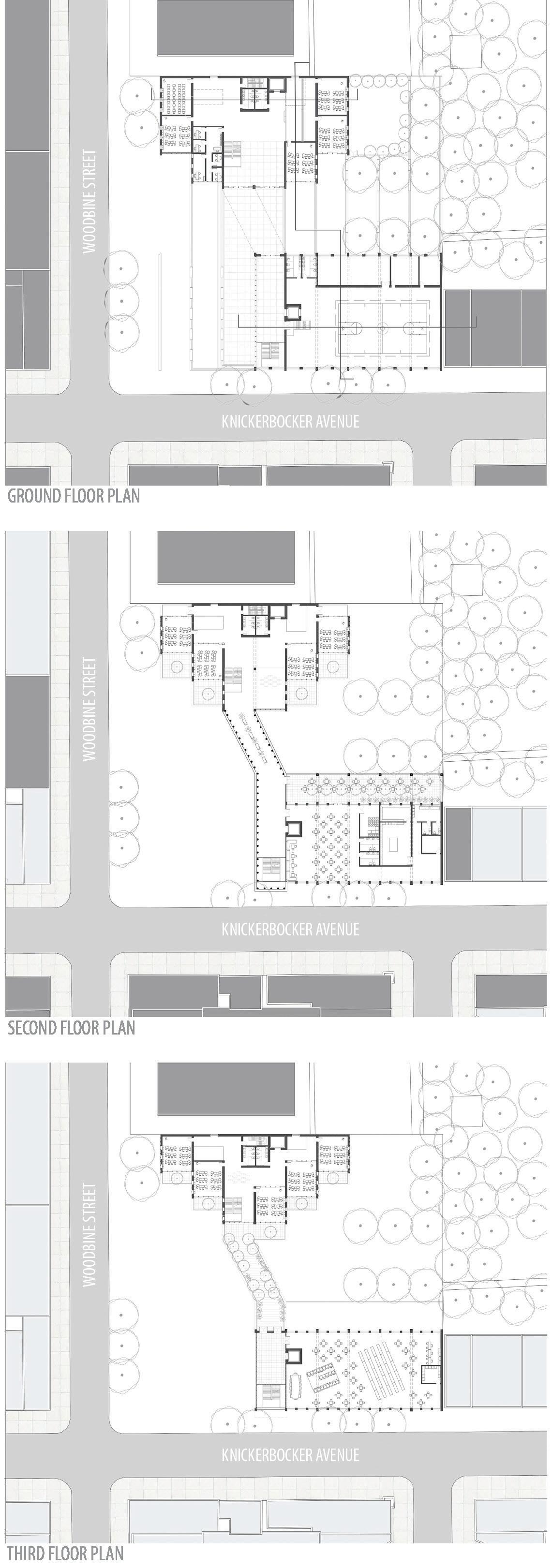
1. Observations on- site showed that, in the neighbourhood, the streets have more residential buildings (private), while the avenues have mixed-use ones (private/public/commercial).
2. The school is divided into two buildings: private areas (classrooms and administration) and public areas to be shared with the local community (library,gym,cafeteria).
3.Theprivatebuildingisplaced onWoodbineSt.andthepublic buildingonKnickerbockerAve
4. Then, a grid of 24 feet (7,3 m) is used to assist the structure ofthebuildings.
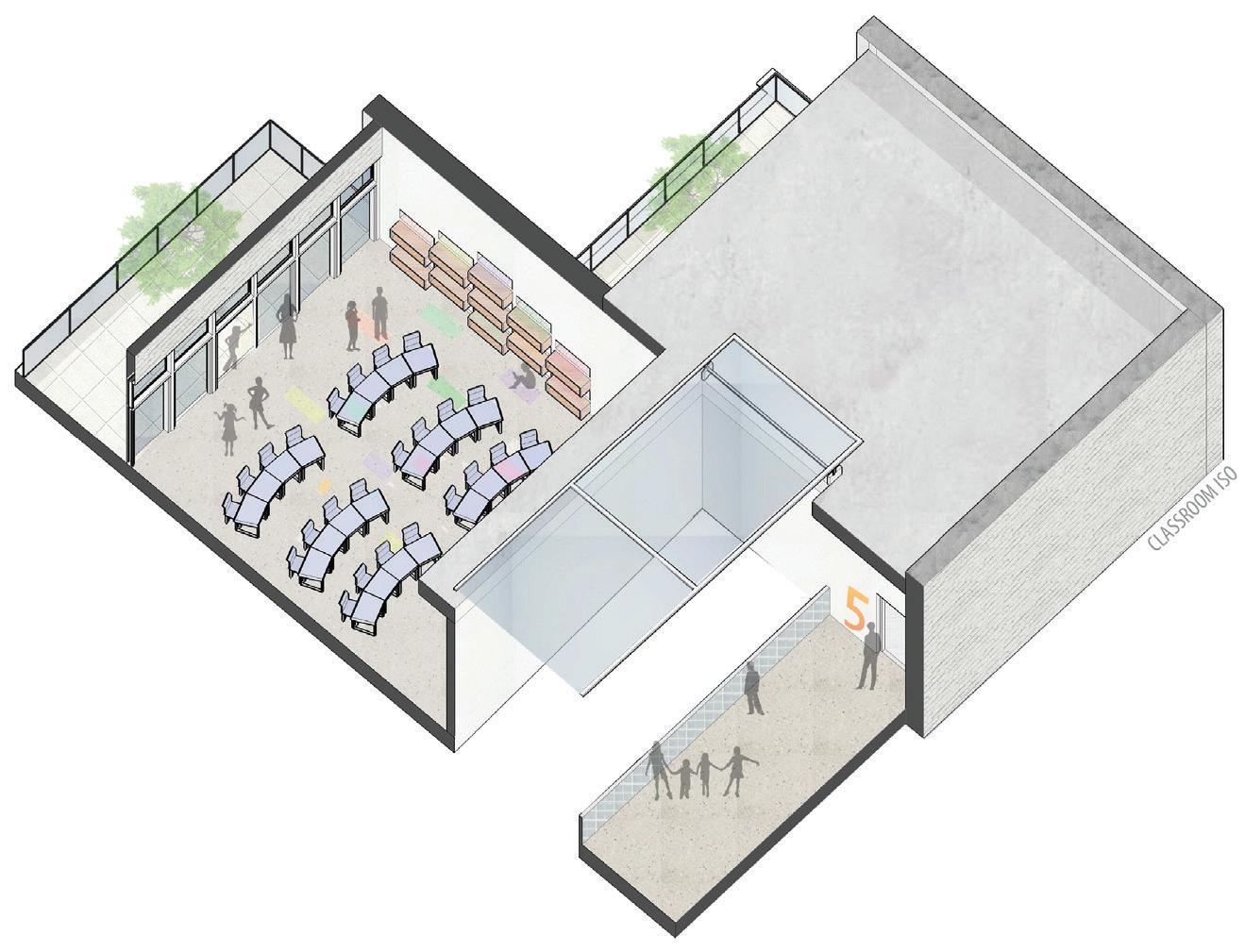
5. Following the grid, the classrooms on the private building are placed in steps that allowmoresunlightinsideanda terracetoeachclassroom.
6. A pedestrian bridge connects the two buildings. The remaining area of the site functionsasapublicopenspace and a connection from the cornertotheplaygroundpark.
27
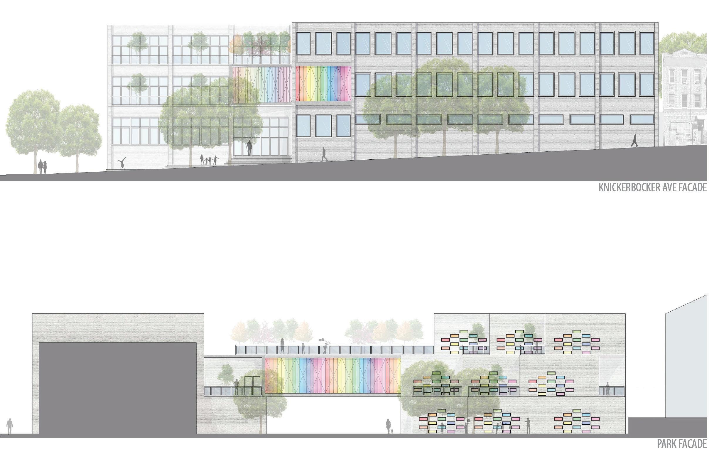
KNICKERBOCKER AVE. FACADE
PARK FACADE
Public Building Public BuildingBridge Private Building Private Building
The Bushwick Elementary School’s design is thought through a multiscale approach. Beginning from the classroom, concerning the pedagogic work, going to the building’s facades, scale, and community areas. Thedeskandtablefurnitureare also designed to be comfortable and to allow different layouts according to pedagogical activities.
The classrooms are placed in steps that allow windows on two facades to provide natural light and ventilation. The smaller windows are colourful, to give a ludic atmosphere, and intercalatewithbookshelves.
Overall,theschoolsupports260 students and each classroom fits up to 24 children with dimensions of 24 feet x 28 feet (7,3mx8,5m).
GROUND FLOOR PLAN
SECOND FLOOR PLAN
THIRD FLOOR PLAN
28
1 1 2 3 4 3 5 6 3 7 1 2 3 4 5 6 7
Access Administration Classroom Sports area Bridge Cafeteria area Library area
PRIVATE AND PUBLIC BUILDING SECTION
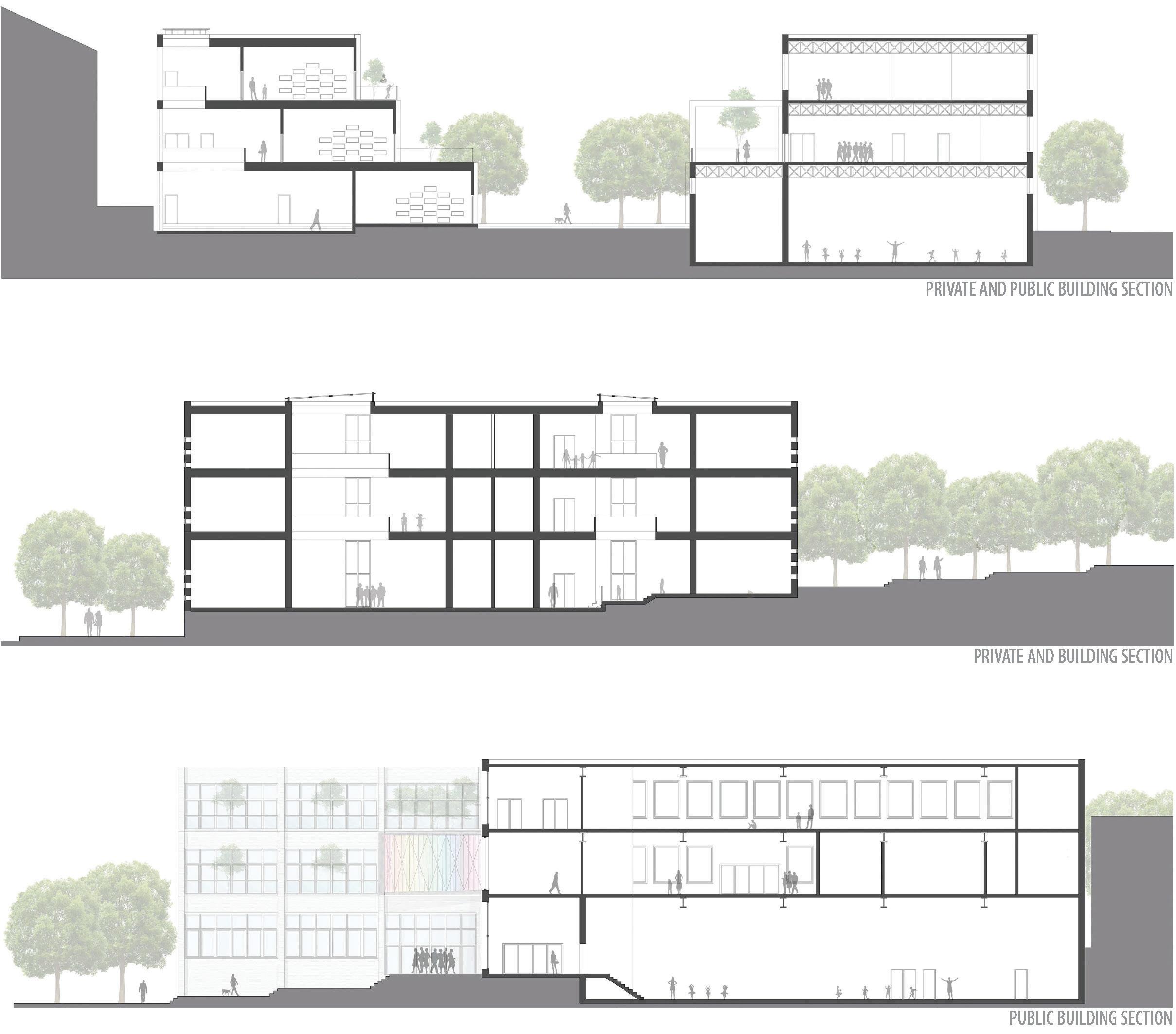
PRIVATE BUILDING SECTION
PUBLIC BUILDING SECTION

Classroom Classroom
ClassroomSports area Sports area
Elevator WC
Cafeteria Cafeteria
Library Library
CLASSROOM MODEL
The private building, used by students, teachers, and the school staff, contains the classrooms for kids from kindergarten to fifth grade, rooms for special classes and theschooladministrationarea.
The publicbuilding, dedicated to students but also open to the community, holds the gymnasium and sports area on the ground floor, the cafeteria with terrace on the upper floor, and the library with computer andstudyareasonthetoplevel.
The scale of the elementary school is thought in a way that matches the adjacent buildings, seekinganarchitecturaldialogue with them. On the façade, white brick is used to communicate with the surroundings buildings alsomadeinbrick.
This project sought to design an elementary school that is good for the educational development of a child, that provides multi-purpose spaces for the pedagogic program, and that is also connected to the urban surroundings. This place provides the local neighbourhood with public spaces and meeting areas that aim the development to the communityasawhole.
30
SITUATION PLAN MODEL
LEAVES ON THE EDGE
TYPE: Metropolitan Approach Proposal
Team Work (five people) - Workshop
LOCATION: Rio de Janeiro, RJ - BR
SUPERVISOR:
Antonella Contin (PoliMi)
Maria Fernanda Campos Lemos (PUC Rio)
Giovanni Santamaria (NYIT)
YEAR: 2018
The uncontrolled urban expansion, the deforestation of Mata Atlantica and the poor water management are crescent problems for the metropolitan region of RiodeJaneiro. These are interconnected issues in need of an interdisciplinary approach, that uses transversal management skills to deal with the complexity and fragmentationintheCityofRio.
Rio de Janeiro was founded in 1565 by the Portuguese that had recently arrived in the tupiniquim country. Since then, the city grew to become secondmost populous in Brazil. The analysis of the area was made through research, site visits and talks to local leaders in order to identify the strengths, opportunities, weaknesses and threatsofthecity.
As for strengths, Rio de Janeiro has, among others, biodiversity, natural and historical heritage, and a tropical biome that indicates fast growth of the flora. The weaknesses and threats are related to the poor infrastructure of the city, lack of awareness of the importance of ecology, and uncontrolled urban sprawl. Much of these problems are associated with food production and the monocultural agriculture in periphericalareasofthecity. There is urgency to integrate a system of controlled development that preserves the natural reserves of Rio. Therefore, this proposal takes an agro-archaeological tactic for the application of nature itself and agriculture as agents to improve infrastructure and to controlurbansprawlinRio.
31
O4
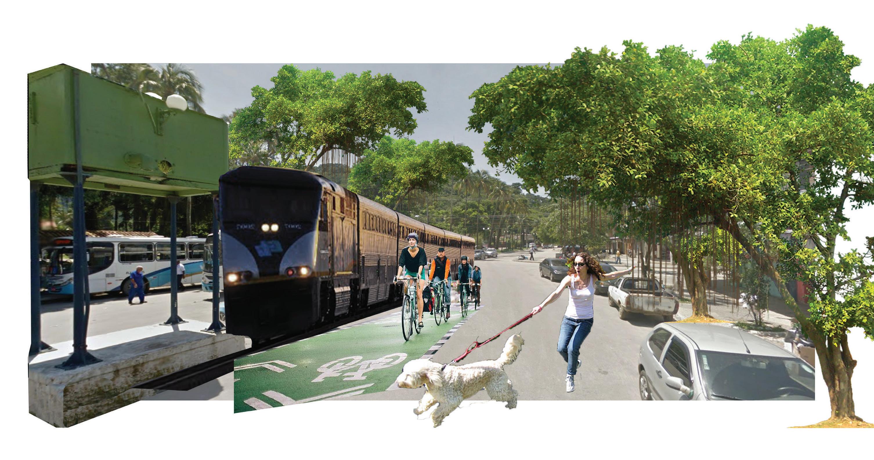
PERSPECTIVE COLLAGE
PLAN OF ACTION
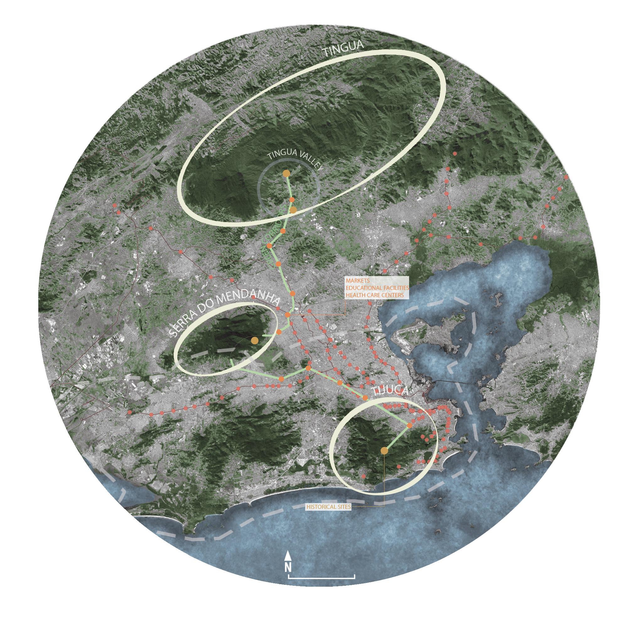
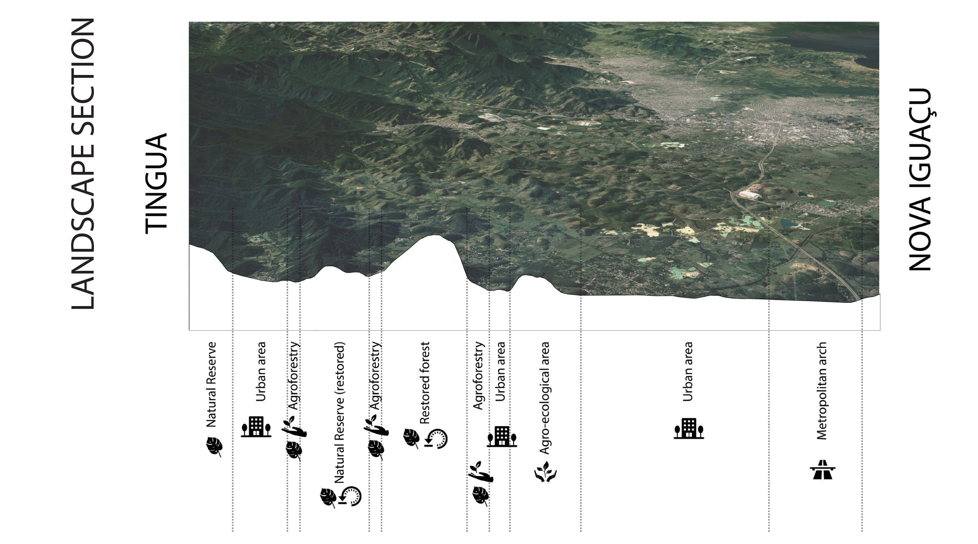
The proposal is to connect threeecologicalzonesinthecity by means of green corridors. The area of Tingua, a protected zone, Serra do Mendanha, a leisure zone, and Tijuca, a touristicandurbanzone,should beconnectedbygreencorridors for preservation and integration ofthesenaturalreserves.
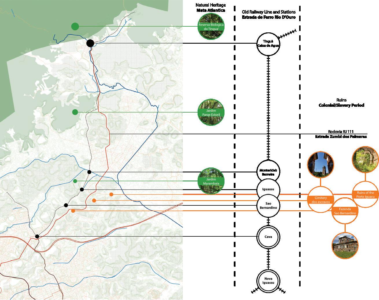
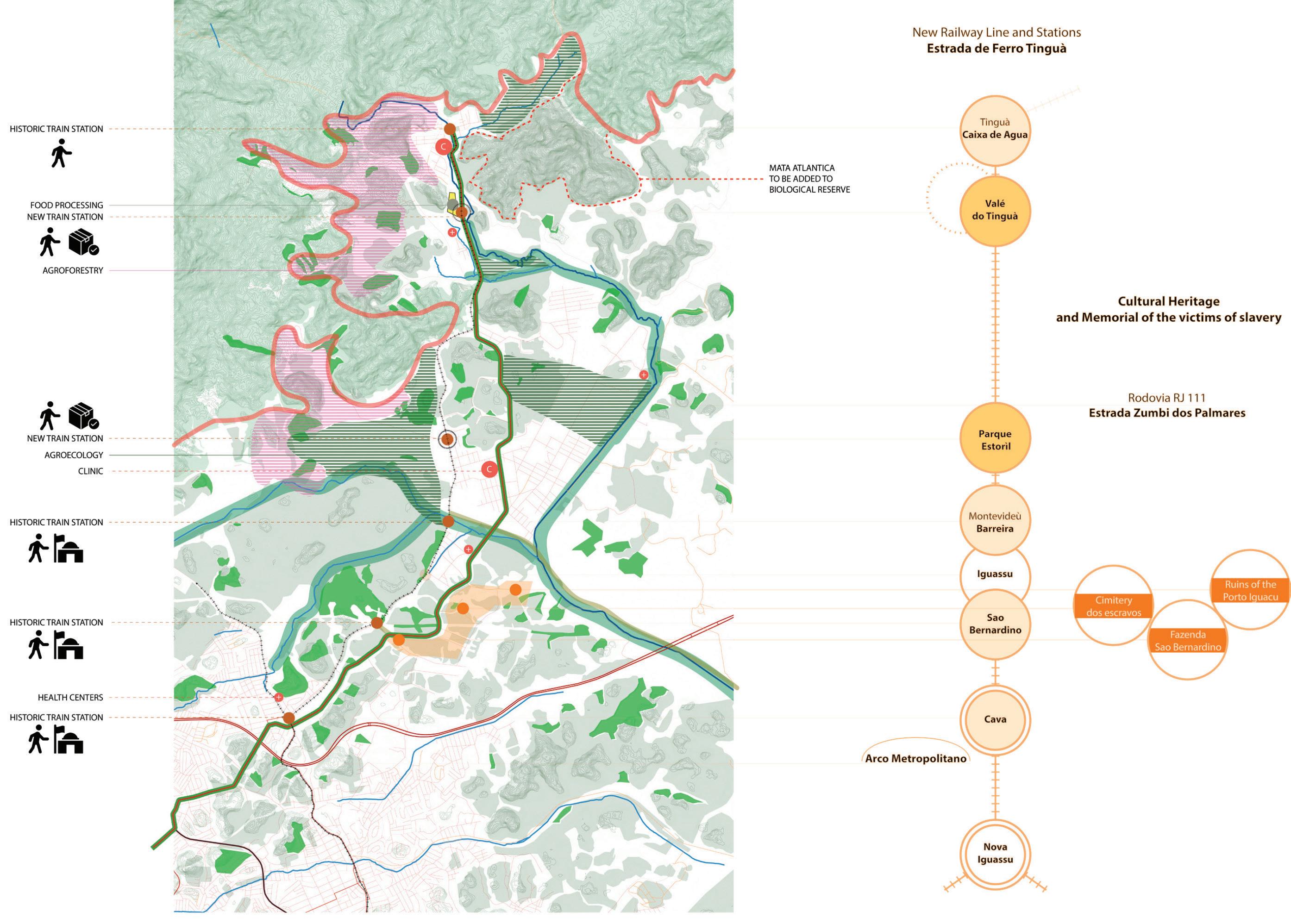
This approach is developed by creating a green network to connect the metropolitan scale to the Tingua Valley while introducing an agro-ecological economy. In addition, a new rail-way line, where the Estrada de Ferro Tingua existed, is suggested. This railway remits to the historical development of
the city, going through cultural heritage points, recreating train stations and making the needed connection between the centre and peripherical areas for transportation of goods and peopleonametropolitanscale.
32
10
km
RiodeJaneiroCity
ANALYSIS
INFRASTRUCTURE EVOLUTION
INTERVENTION
Site visits demonstrated the potential to use the region of Tinguaformoreecologicalfood production for the city. Tingua is located in the peripherical area of Rio, close to a natural reserve, and has an agricultural economy with potential for the implantation of agroforestry as land-use management, food production and nature preservation. Another opportunity can be associatedwiththehistoryofthe city. The development of Rio since 1565 indicates a dormant historical colonial heritage that couldbeusedforbothhistorical tourism and educational awareness of the importance of the existing nature in the development of the city to what itisnowadays.
33
PLAN
Cemitery of slaves Ruins of Porto Iguacu Farm Sao Bernardino Cemitery of slaves Ruins of Porto Iguacu Farm Sao Bernardino Rio
MASTER
de Janeiro City
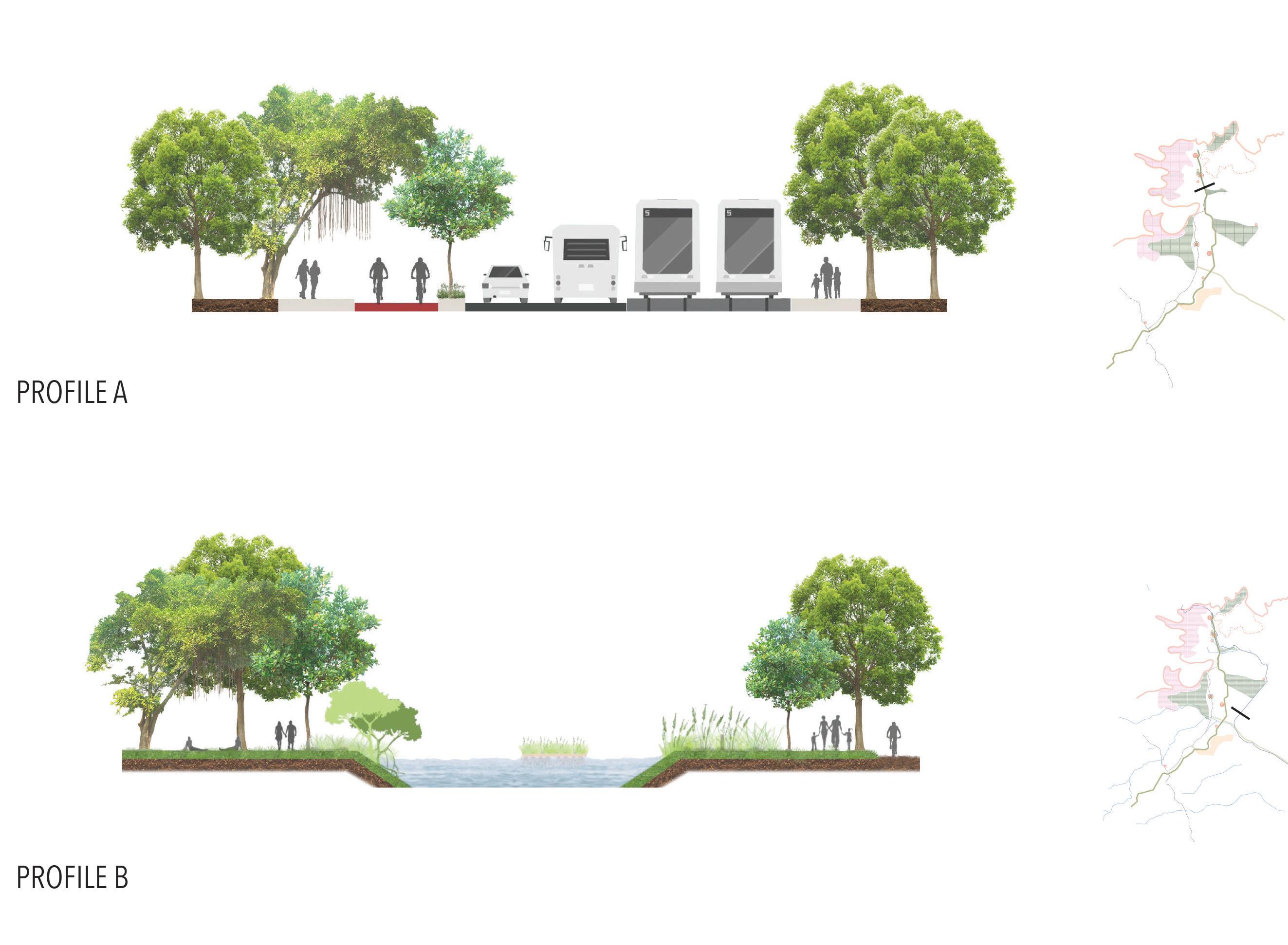
The landscape section shows the integration of the elements proposed with the existing urban and natural context on the metropolitan scale. As a glimpseofwhatthisintervention represents on a local scale, the street’s profile shows the proposals for the railway connection that could cross the metropolitan re-gion from Tingua to the city centre (see profileA)aswellastheproposal for the areas of green corridors connecting the reserves (see profileB).
Therefore, this plan took a metropolitan approach to manage the urban expansion in Rio, to improve infrastructure andtocontroldeforestation.
34
LANDSCAPE SECTION
STREET PROFILE A
STREET PROFILE B
PAISSANDÚ RESIDENCE
TYPE: Social Housing Team Work (four people)
Architectural Competition for ideas
LOCATION: São Paulo, SP - BR
YEAR: 2018
NOTE:
The challenge of this design process lies in the fact that it was developed in two weeks over virtual meetings only. Also, in the team of four, two people I have never met before.
SãoPaulo has a crescent issue concerning homelessness and theneedforsocialhousing.This situation can be easily observed in the city centre, where Largo doPaissandúislocated.
There existed the building WiltonPaesdeAlmeida, which was exemplary of Brazilian modern architecture from the 1960s. The construction has been home to companies and public institutions, but after being abandoned, was occupied by squats and became informal housinginthecitycentre.
In May 2018, a fire destroyed the building entirely and some dwellers even lost their lives.
The ones that survived ended uphomeless.
Motivated by this disaster, seeking to house these people, and to democratise the city centre spaces of São Paulo, this project develops a social housing idea with an urban potential by designing a mixeduse tower on the same site that the Wilton Paes de Almeida buildingwasdestroyed.
Thedesigniscommittedtohigh architectural quality, but also to enhancing interactions among the dwellers and the urban spaces of the city. To this, it follows the concepts of solidary economy, shared spaces for everyday life and bioclimatic architecturalstrategies.
35 O5
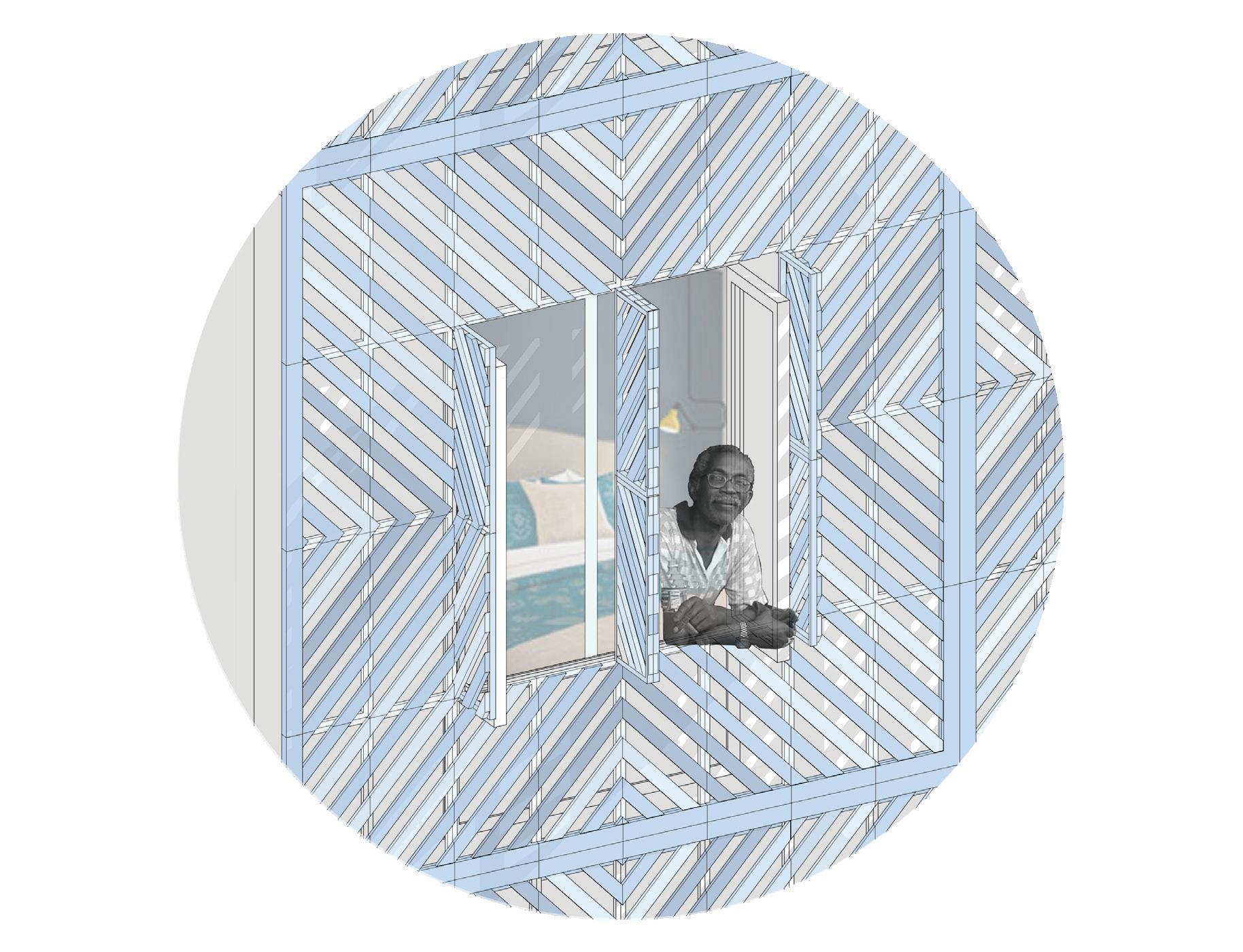
FACADE DETAIL
VIEW
36
PERSPECTIVE
PEDESTRIAN’S VIEW
DESIGN PROCESS DIAGRAM

1. Twenty floors of housing, distributing 10 apartments per floor and keeping the scaleofthepre-existing building.
2. Alignment of the building to the corner, creating a garden between the tower and thenextsite.
3. The floor type is mirrored along the central axis to have apartmentsfacingthree ofthefourfaçades.
4. A central opening is created to provide natural cross-ventilation in apartments and corridors.
5. Another opening is placed on the main façade to assist the natural ventilation insidethebuilding.
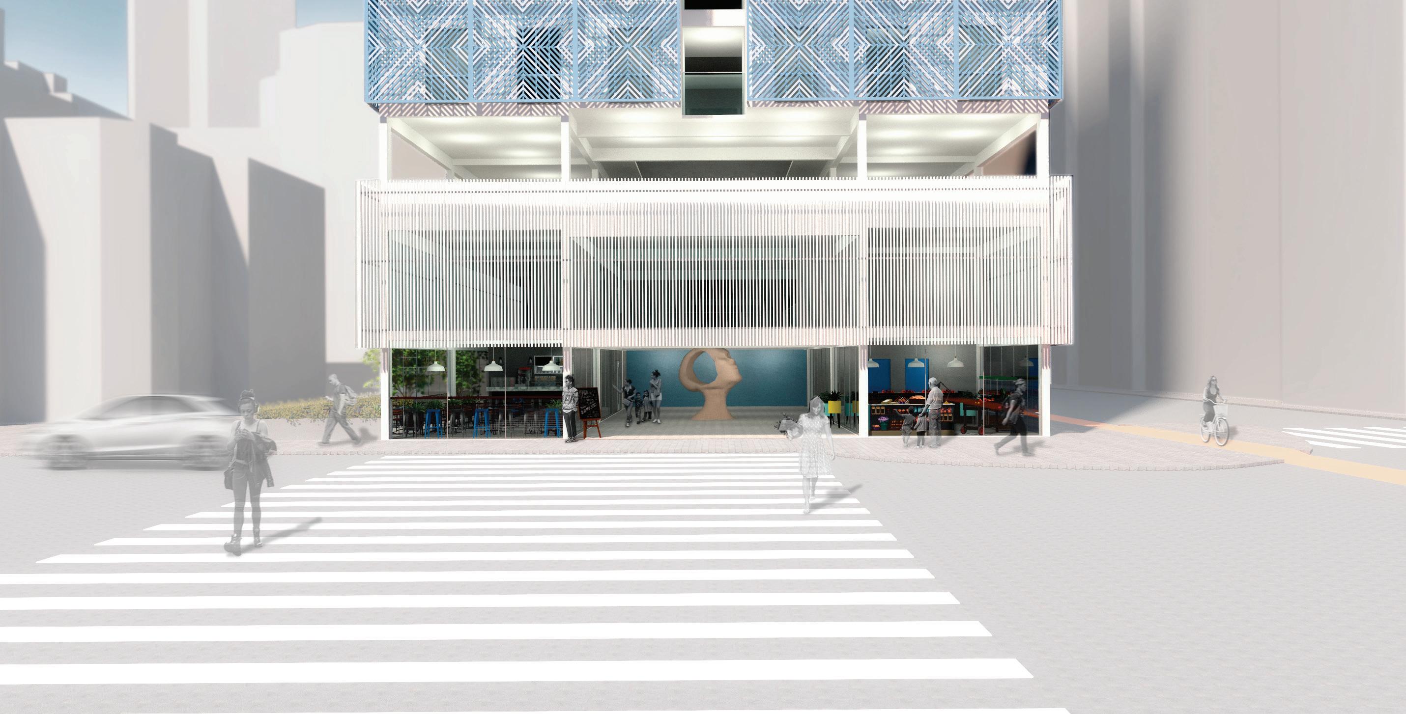
6. The tower is elevated on a threefloorbasethatcontains the public program of thebuilding.
7.Aterraceandshared areas for residents are created in between the base and the tower for a smooth transition of usesinthebuilding.
8. Lastly, an envelope system is placed on the three main façades for sunshading and ventilatedfaçades.
Thebioclimaticstrategyadopted in the building works with an integrated system of food-share, vegetable and fruit production (1), ventilated façade (2) and crossed ventilation (3), pluvial garden (4), rainwater collection andstorage(5)(SeeSection).
The program in the tower follows accordingly: the base has areas of public access, the coffee bar, library and stores - that could also sell products made by residents or vegetables producedontherooftop.
Then, the third floor and the rooftop have areas to be shared byresidents.Onthisfloor,there aremeetingareas,aplayground, alaundryroom,apluvialgarden and a shared kitchen. On the rooftop, there are greenhouses and areas for vegetables and fruitsproduction.
On the tyoical floor plan, the apartmentshavethelivingroom and bedrooms with windows facing the outside while the kitchen and bathrooms face the internalcorridor.
37
BUILDING
SECTION
BASEMENT FLOOR Access Greywater cistern Rainwater cistern Cistern Car parking Bike parking Front desk Gas room Warehouse Ramp Toilet Stores Coffeebar
23 23
SECOND 23
FLOOR Classroom Staff area Lounge Library Locker room Loundry Shared kitchen Meeting area Playground Apartments Water tank Garden tools room Community garden
23,5 m² 6 units/ floor 120 apt. total
2 BEDROOMS
32,8 m² 2 units/ floor 40 apt. total
3 BEDROOMS 14 15 16 17 18 19 20 21 22 23 24 25 26
38
PLAN THIRD FLOOR PLAN GROUND
1 BEDROOM PLAN TYPICAL FLOOR PLAN APARTMENTSISO
42,7 m² 2 units/ floor 40 apt. total FLOOR PLAN TERRACE FLOOR PLAN 1 2 3 4 5 6 7 8 9 10 11 12 13
THANK YOU