
the great book


There are many occasions and instances of the fight against the water in the history of the Netherlands. It is therefore not surprising that the National Archives stores contain many kilometres of documents about efforts to hold back the water or even to profit from it. They include thousands of maps and drawings on the themes of dyking, land reclamation, river improvement, canal building, and the construction of all kinds of engineering works, such as bridges, locks, and harbours. All of these civil and cultural engineering maps have their origins in hydraulic engineering. Some of them, along with legal maps, are among the oldest in the National Archives collection.
– Nova Roma on the North Sea (1553) / dyke construction
– The un-dyked Beemster (1607) / polder
– The silting of the great rivers (1769) / river correction

– The Spanish canal issue (1776) / irrigation project
– The major land and water connections (1822) / channel, road, and rail construction
– Holland at its narrowest (1863) / digging a canal to the sea
– The Delta Act (1954) / shortening the coastline
– Guest author Rene Haubourdin (posthumously) / water management inspector j. blanken


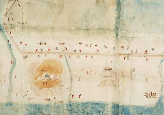
Concept van de Bedijkingen van de Zijpe over lange jaeren gedaen (Concept of the dyking of the Zijpe spanning a long period): map of the northern part of North Holland with the islands of Eierland, Texel, Wieringen, Huisduinen, and Callantsoog and dyke work on the Zijpe
Jan van Scorel
c. 1552-1553
Scale approx. 1:25,000, north is left
Manuscript on paper, mounted on linen, coloured, 80 x 240 cm
4.vth inv. no. 2486
Dyke construction map
This map of the dyking of the Zijpe is usually attributed to Jan van Scorel (1495-1562) but may have been made by one of his pupils. Van Scorel was a polymath, a homo universalis. In addition to being a painter, he was also a cartographer, inventor (for example, of a dredger) and businessman. He was therefore sometimes called the ‘Leonardo da Vinci of the North’. He went on a pilgrimage to Jerusalem, but also did a grand tour of Italy. Van Scorel had one foot in the Middle Ages and the other in the Early Modern period. To finance his most important work, the reclamation of the Zijpe, he used his network to engage the interest of merchants, writers, and painters. His dyke plan ultimately turned out to be a financial failure.
Background
The Zijpe was the first major dyking project in North Holland. The Zijpe, a tideway that had formed between Petten and Callantsoog at the end of the 12th century, had always become submerged at high tide. In 1392 it was acknowledged by a comital commission that the Zijpe needed to be dyked in the national interest. In 1398 Duke Albrecht of Bavaria tried to bring this about, but his initiative did not result in a concrete project. In 1438 Duke Philip of Burgundy asked the Court of Holland, Zeeland, and West Friesland to help him find supporters for a new attempt to achieve a dyke; this again was in vain. During the 16th century, however, a new argument arose in favour of dyking: in the past, the rationale had been to protect West Friesland from the sea, but now it was also emphasised that reclamation could yield agricultural land. Yet it was only in 1552 that the first dyke was actually built.
First dyking of the Zijpe
Jan van Scorel introduced his initial plans to dyke the Zijpe in 1549. He asked Emperor Charles V for permission to reclaim ‘ den weert, schorre, sant ende slijck geheten de Sijpe’ (the lands, inlets, sand and silt called the Sijpe). He said that the boundaries of the area were ‘from Petten to Huisduinen and also near Wieringen to the West Frisian sea dyke’. Charles V gave Van Scorel official permission (patent) to reclaim the Zijpe in March 1552. Immediately afterwards, in April, he travelled to Antwerp, where he tried to gain the interest of wealthy traders at the stock exchange, in his capacity as ‘fundraiser’, seeking to obtain the necessary capital. Van Scorel had taken a few barrels of ‘rich marine clay’ to the Antwerp stock exchange with him, to convince potential buyers about the fertile soil that would emerge after reclamation. Van Scorel’s large and highly detailed map was part of the original patent application. It may have also served as propaganda material for the project and the map was on display at the Antwerp stock exchange. Another map that may have served the same purpose is what we would now call an artist’s impression of the Zijpe dyking project. This map was created around 1550. Clearly visible are the seven pilgrim churches of Rome. This reference to the city of Rome related to the fact that Van Scorel had coined the name ‘Nova Roma’ (New Rome) for the newly reclaimed land. Partly due to his good contacts, Van Scorel was able to source most of the funding for the dyking from Antwerp. Flemish speculators and investors were interested in Van Scorel’s lucrative project and bought more than half of the land. With that, the work could begin.
At work
On 24 May 1552, Helico Huijbertszoon, the dyke warden of Schagen, started on the ‘construction of the Zijpdijk’
detail / eierland island - the collection of eggs

The small island of Eierland (later part of Texel) is drawn on the far left of the map. In the middle of the 16th century this belonged to Maximiliaan de Cocq, Lord of Zevenbergen, who leased out the farmhouse with the surrounding lands, hunting rights, and duck decoy. Maximilian de Cocq was executed by Alva in 1568 and his possessions were confiscated. In 1629 the Delegated Councils of the States of Holland and West Friesland bought the island with all the rights attached to it. The construction of the sand dyke between Texel and Eierland could therefore be completed without legal obstacles in that same year. What this detail portrays so beautifully is the activity of collecting eggs: seagull eggs, mainly intended for ‘export’ to the bakers on the mainland.

with a team of twelve dyke workers. It was the start of a project that ultimately encountered many setbacks. While Jan van Scorel may have devised a wonderful plan, he had not taken much account of the practicalities. His contractors and dyke workers squandered the invested funds and the newly installed locks were damaged by the stormy weather.
In the summer of 1552, Van Scorel called in the assistance of a seasoned dyke builder, Andries Vierlingh, the dyke warden of Steenbergen. This practical and experienced hydraulic engineer was constantly aware of the treacherous water and warned against the optimism of inexperienced ‘wijse clerken … op welcke men niet en behoort te lettene, want zij Neptunium noyt gram ende leelycken gesien en hebben’ (wise clerks … to whom one should not pay heed, for they have never seen Neptune angry and ugly). He wrote that Van Scorel and his investors had never even seen a dyke. Vierlingh eventually managed to get the work going again. Within 17 months the job was done. Simon Meeuwszoon from Edam was commissioned to measure the polder layout and then define the plots. In the summer of 1553, the polder layout was finished and the plots could be allocated by drawing lots.
detail / work on the dyke
A remarkable feature of Van Scorel’s map is that he draws settlements and many human activities in great detail. Here, for example, we can clearly see fishing activities on the beaches and people working on the sand dyke. The drawing was likely made before the actual work started, because we know from dyke builder Vierlingh’s report that ultimately no oxen or wheelbarrows were used, although they can be seen in this drawing. Sand was mainly transported by means of a mollebord , a wide shovel pulled by horses.
Van Scorel withdraws
Two years after ground was first broken, the situation appeared to be more favourable than it actually was. For the investors, the dyke plan soon proved unprofitable. The people who bought the land in the Zijpe had been promised that the investors would bear all the costs of completing the works, but this was not forthcoming. Financial difficulties and dissension within the parties executing the project caused Van Scorel to formally withdraw from the enterprise in 1554.
In 1555 a storm made holes in the still fresh dykes. The Zijpe sea dyke was breached in several places and fell into a sad state of disrepair. There were various subsequent attempts to build a dyke, but they had few lasting consequences. Then in 1573, at the start of the Dutch Revolt, the people of Holland decided to flood the Zijpe again to delay the Spanish siege of Alkmaar. In the end, it was 1597 before the Zijpe was definitively reclaimed.
Van Scorel calls the newly reclaimed land Nova Roma, or the New Rome. Here, Jan van Scorel creates an artist’s impression of the area that will be dyked, showing seven new churches. These churches are named after the seven pilgrim churches of Rome, representing the planned new village centres. The sacred number seven refers to the seven hills of Rome and the seven days of creation. In the end, Jan van Scorel’s idea did not materialise in the polder layout after the land was reclaimed.
The ‘Red Brazilian Register’, 1540-1555 Grafelijkheidsrekenkamer of Rekenkamer der Domeinen van Holland: Registers en Stukken 3.01.27.01 inv.no. 9

Jan van Scorel receives imperial approval for the dyking of the Zijpe, 31 March 1552. This permission is included in the Red Brazilian Register.
fol. 226: ‘Octroij verwurven bij haeren Jan van Schorel priester canonick tot Ste Marien binnen Utrecht omme te moegen bedijcken de Zijpe gelegen in Hollant ’ (‘Permit obtained by Mr Jan van Schorel canon to St. Mary’s within Utrecht to be allowed to dyke the Zijpe situated in Holland’).

In 1553, officials of the Court of Audit of Holland drew up conditions for allotting the new dykes. Land surveyor Simon Meeuwszoon of Edam was given the task of measuring the polder layout (allotment) and defining the plots. The church shown in the centre of the map was never built. During that year the roads, canals, and ditches were completed. On 23 October 1553 a large meeting was held in Petten, and all the plots were assigned to the new owners by drawing lots.


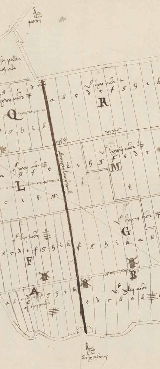 Allotment map of the Zijpe from 1553 by Simon Meeuwszoon of Edam Van Wassenaer van Duvenvoorde, 3.20.87 inv.no. 323
Choro-Topographische Kaart der Noordelijke Provincien van het Koningrijk der Nederlanden
[…] (Choro-topographical map of the Northern Provinces of the Kingdom of the Netherlands, made by the topographical office of this State, according to the design and the geodesic and astronomic observations of lieutenant general baron Kraijenhoff, commander of the Military Order of William, governor of Amsterdam, inspector-general of the Fortifications, of the Corps of Engineers, the Pontoon Engineers, Miners and Sappers)
C.R.T. Kraijenhoff1829
Scale 1:115,200
Copperplate print on silk, coloured, 87 x 94 cm
4.krf inv. no. 11, sheet viii
Geometrically reliable map of the unitary state
In 1798, at the time of the Batavian Republic, the Uitvoerend Bewind (Executive Authority; the government at the time) introduced a new administrative structure. However, when this authority wanted to cartographically record the new unitary state, it was found that the regional maps made during the Republic did not correspond with one another. C.R.T. Kraijenhoff was tasked with aligning the maps on a correct geometric foundation. While Blanken could be called the king’s canal digger, Cornelis Kraijenhoff was William I’s undisputed cartographer and fortification builder.
One of his greatest achievements was to systematically map the entire territory of the Netherlands using triangulation. It is the first ever map of the whole of the Netherlands made on a sound geometric basis. Kraijenhoff was commissioned by the Nationale Vergadering (the National Assembly of the Batavian Republic, the parliament at the time). In October 1798, they instructed him to create a large map of the Batavian Republic (Groote kaart van de Bataafsche Republiek), at a scale of ‘800 Rhenish rods to the thumb’ (1:115,200).
The first sheet, covering Zeeland, was published in print in 1809, and it was 1823 before the Kraijenhoff map was completed. That is when the ninth and last sheet was published, depicting the province of Groningen and the eastern part of Friesland. A reprint was required as the map sold out quickly. After this, as early as 1829, a full revision of the first eight sheets of Kraijenhoff’s map was issued. It also included a change to the numbering of the maps.
Even before the complete map was published in 1823, other map materials were issued, using Kraijenhoff’s measurements and drawings; we call these ‘derived maps’. In the mid-19th century, the Groote kaart was superseded by the Topographic and Military Map of the Kingdom of the Netherlands (tmk), which was topographically even more detailed (see page 222). However, as a military overview map, Kraijenhoff’s map remained serviceable for quite some time.
Cornelis R.T. Kraijenhoff
Cornelis Rudolphus Theodorus Kraijenhoff (17581840), son of Cornelis (see page 28), was one of the patriots who took advantage of the French period (17951813) to introduce innovations. As a physician, physicist, hydraulic engineer, topographer, cartographer, military engineer, and Minister of War, he played a role in all the political and military upheavals of his time (1787, 1795, 1799, 1809/1810, and 1813), and witnessed five different forms of government. The extensive projects that were accomplished under his management are of great importance for the Netherlands: the triangulation for the first geometrically reliable map of the country; his water management surveys that led to the national introduction of the Amsterdams peil (Amsterdam level; a standard measurement for water levels); the organisation and reorganisation of the water defences in Holland and Utrecht; and the enormous fortification project in the south of the Netherlands: the Zuidelijk Frontier (Southern Frontier).
Triangulation for the ‘Groote kaart’
Kraijenhoff’s original plan was to compile his new map on the basis of existing map material, such as the provincial maps ( provinciekaarten). However, it soon became apparent that the existing maps were inconsistent with one another, that there were large gaps in the available topographical information, and that there were areas such as Drenthe, the Veluwe, and Groningen where new area surveys would be necessary. The geometrical foundation needed to draw the new map was also lacking.
Kraijenhoff therefore decreed that a triangulation of the entire country would be carried out. This measurement was to determine the location of 111 specially designated vertices: fixed points in the landscape, precisely recorded so that they could later be used for measurements.
In most cases, church steeples were used for this purpose. The completion of this ‘primary triangulation’ of the Netherlands revealed significant errors in old maps. For example, the locations of the Zuiderzee and the Wadden Islands had systematically been drawn incorrectly.
From 1798, many different surveyors, engineers, draughtsmen, and scientists worked on the map. The geographical engineers who worked under Kraijenhoff’s supervision were also instructed to collect data on agriculture, soil conditions, industry, and the number and type of inhabitants.


The work on the triangulation was slow, partly because Kraijenhoff was engaged in many different tasks at the same time. For years, groups of surveyors travelled across the country in summer to take measurements from steeple to steeple.
With his primary nationwide triangulation, Kraijenhoff had also unintentionally laid the foundation for the Dutch cadastre. With a secondary triangulation that was even more accurate, the cadastre was later able to overlay its own measurements, as it were, onto Kraijenhoff’s Groote kaart.


Southern Frontier
Another of Kraijenhoff’s large military projects was the defence line in the south of the Netherlands (now Belgium). That line was called the Zuidelijk Frontier This zone with defences was the direct result of the agreements made by Napoleon’s conquerors in Vienna. The idea was that the new state, the United Kingdom of the Netherlands, should form a buffer (military and otherwise) against France. On 26 September 1815, Inspector-General of the Fortifications Kraijenhoff received the instruction to ‘secure the southern frontiers’. In other words: the southern border of the Netherlands had to be protected.
the large map by kraijenhoff
Kraijenhoff travelled along the new southern border. On the basis of his report, the king gave him ‘free disposal [...] of the personnel of the Corps of Engineers (only excepting the Directors of the Fortifications), in order to make use of them when required under the circumstances and in the interests of the service’. Kraijenhoff remained a reliable advisor and executor of defence lines (often using water) and fortification systems for King William I for a long time.
Financially, Kraijenhoff’s project got seriously out of hand. In 1807, before even one sheet of the map had been published, the costs had already risen to 105,000 guilders, a gigantic sum for that time. About 40 surveyors and military engineers were assigned to perform the triangulation, copy maps, and create new maps.
detail / peat cutting in drenthe This is sheet VIII of the Groote kaart from 1823. The Kraijenhoff map sheets vary in quality. This is related to the fact that Kraijenhoff had to settle for the topographical knowledge available for each area at the time. detail / deluxe edition Eight maps, title page, and index, and case in the form of a book from the Kraijenhoff family archive. Deluxe edition printed on silk, possibly presented to Kraijenhoff on a special occasion. 4.KRF inv.no. 11 Cost summary of the Kraijenhoff map Staatssecretarie, 2.02.01 inv. no. 270Kraijenhoff was responsible for the Southern Frontier. In the first five years of the reign of King William I, this was the single largest activity in the Netherlands, dwarfing all other infrastructural works. The defence line consisted of several forts. One of them is a fort on the hill alongside the Maas/Meuse at Huy (Dutch: Hoei) in Liège province. Between 1818 and 1823, a new fortress was built on the rock where the castle of Huy once stood. The strategic view from the hilltop is what determined the location for the construction. These drawings date from 1823, when the fort had just been built.


4.krf inv.
4.osk inv. no. w17.12
The Situation Maps subfile in the archive of the Army Corps of Engineers (4.osk) contains many topographical maps in manuscript form, which are considered to be ‘predecessors’ of the Topografische en Militaire Kaart van Nederland (tmk ; the topographic and military map of the Kingdom of the Netherlands; see page 222). Together, these military maps produced in the period 1769–1824 were a reasonably comprehensive patchwork covering all of the Netherlands. However, we have to wait until the mid-19th century for more uniform cartography. In 1798, Kraijenhoff also gained access to this map created between 1788–1792 by Captain J.H. Hottinger and the Hattinga atlases, both from the Council of State’s map collection, which was discontinued at that time.

 Sheet 12 (Emmen) of the Atlas Topographique van het Frontier des Yssels, Wedde & Westwoldingerland by J.H. Hottinger, 1788-1792
Legend of the ChoroTopographic Map
no. 11, sheet a
Sheet 12 (Emmen) of the Atlas Topographique van het Frontier des Yssels, Wedde & Westwoldingerland by J.H. Hottinger, 1788-1792
Legend of the ChoroTopographic Map
no. 11, sheet a


Kaartje van het eijland Ceylon. Eerbiediglijk Gepresenteerd
aan den Wel Edel en Agtbare heer Raad Extra Ordinaris van Nederlands India en Ceylons gouverneur Gerrard Joan Vreeland (Small map of the island of Ceylon. Respectfully presented to […] Gerrard Joan Vreeland)
Balthus van Lier
1751
Scale approx. 1:685,000, north is right
Manuscript on paper, coloured, 75 x 79 cm
4.miko inv. no. w42
The Elephant Map of Ceylon
The name by which this map is known, the ‘Elephant Map’, interestingly does not refer to the geographical information drawn on it, but to the decoration in the cartouche. It features an elephant holding in its trunk a log that has been stripped of its bark. This is undoubtedly a cinnamon tree. Cinnamon was a product that was found in large quantities in Ceylon (present-day Sri Lanka). For many of the European countries that sailed to Asia, the island was therefore a greatly desired possession for trade. The voc also wanted to control Ceylon for the same reason; the monopoly on the cinnamon trade brought the Company a great deal of money. Dutch voc employees forced the original inhabitants of the island to work in cinnamon growing and production, just as traders and colonisers from several other European countries had done before them. This is also reflected in the cartouche on this map: a number of cinnamon peelers are removing the bark from the cinnamon trees. Members of the native population are also displaying other products grown in Ceylon. This map originally belonged to the collection of Johan Gideon Loten, the governor of Ceylon on behalf of the voc in the mid-18th century.
Administrative regions and fortifications
This map, which was intended to provide a picture of the administrative division of the island of Ceylon in the mid-18th century, was created by Balthus Jacobszoon van Lier. It not only shows the Kingdom of Kandy, but also the various regions into which the voc had divided the island. Around this central map are no fewer than 22 plans of the voc ’s forts and fortifications on Ceylon. Clockwise from the top-left, they are: Ponnerijn, Aripo, Jlipkarwe, Menaar, Baticaloa, Oostenburgh, Trinconomale, Katoene, Mature, Gale, Calpentijn, Hangwelle, Nigombo, Calture, Colombo, Jaffanapatnam, Punta Pedra,
Hammenhiel, Pijl, Beschutter, Eliphant and de Leeuw. Partly to promote trade and combat smuggling, the Company overhauled numerous forts and lookout posts captured from the Portuguese. Remains of about 15 of these forts can still be found along the coasts of Ceylon.
Johan Gideon Loten (1710-1789)
In December 1731, Johan Gideon Loten sailed as a junior merchant for the voc on the ship Beekvliet. He must have done well in Asia, because in 1752 the Company appointed him as Governor of Ceylon: a prestigious position, because cinnamon production and trade were of great economic importance. In addition to his trade activities, Loten was a skilled topographical draughtsman, but naturally he could not fully concentrate on that. In Ceylon, he commissioned several draughtsmen and surveyors, including Baltus van Lier, to produce drawings of nature, ground plans, and maps. Loten kept most of that cartographic output for himself in his own collection. He wanted to use his collection to write a book about the natural history of Ceylon and other places, but that was not to be. After his death, Loten’s Asian collection was dispersed. Some of it was donated to the Ministry of the Colonies by a private individual in 1835 and thus eventually arrived in the Dutch National Archives.
Cinnamon and elephants
The Machtige Eyland Ceylon (Mighty Isle of Ceylon) was the title of a well-known description by the preacher Philipus Baldaeus of the island we know today as Sri Lanka. Ceylon was successively governed and exploited by the Portuguese, Dutch, and English. It was one of the first places within the voc trading area where the Company itself also acquired large territorial assets by force. By conquering the coastal areas between 1638 and 1658, the voc had acquired a monopoly on the cinnamon trade.
detail / adam’s bridge
At the top-right of the map of the island of Ceylon is the name Adamsbrugh (Adam’s Bridge). This is first mentioned on a map in the 1672 description of Ceylon by the preacher Philipus Baldaeus. Adam’s Bridge is a chain of shoals that connects the north of Sri Lanka/Ceylon with South India. The name is derived from teachings of Islam. An Islamic myth relates how Adam flees to Ceylon/Sri Lanka after being banished from Paradise. He then reached India by way of this island ‘bridge’.

details / rich decoration
Both the cartouche with the elephant and the cinnamon peelers and the one with the dedication to G.J. Vreeland are executed very beautifully. Gerard Joan Vreeland (1711-1752) was the 28th governor of Ceylon. Vreeland had been governor for less than a year when he died on 26 February 1752. Cartographer


The Company would hold it until the English occupation in 1796.

Cinnamon was the main reason for the voc to set its sights on Ceylon. Helped by the local king of Kandy, the voc was able to drive out the Portuguese. The Dutch immediately took over leadership of the global trade in cinnamon. For a century and a half, Ceylon remained a very important and profitable area for the Company. Apart from cinnamon, elephants were also a commodity.
They were popular with Indian rulers, who used the animals not only as status symbols but also in their warfare. The Dutch also exported the animals to other places, such as Persia. The elephants were caught in the vicinity of Galle and Jaffna, where they lived in the wild, using an ‘elephant kraal’, a kind of duck decoy, but for elephants.
Baltus van Lier dedicated his map to Vreeland. the elephant map of ceylon