Appendix I: Land Use Element Image: City of Newark
CONTENTS ● Built Environment ● Development Trends ● Newark Today: Existing Conditions ● Newark360: Land Use Vision ● Future Land Use Plan ● Zoning Recommendations ● Statements of Strategy ● Climate Change Assessment ● Consistency with Other Plans p.6 p.42 p.46 p.48 p.58 p.70 p.80 p.82 p.84 2 | Appendix I.
Introduction
The Newark360 Citywide Master Plan is a comprehensive planning and public engagement effort that began in 2021. The Plan utilizes a narrative structure and story-telling approach to creating an approachable and dynamic policy document the extends beyond the formulaic master plan element requirements set forth in New Jersey’s Municipal Land Use Law.
The Newark360 Plan includes the Newark Today chapter that outlines existing conditions in the city with a focus on activity since the last master plan was adopted in 2012. Broad planning trends are outlined including recent growth and development patterns, the important resiliency and climate change adaptation as flood events and weather extremes become more common and damaging, equity, racial justice, and public health in the wake of the Covid-19 pandemic.
The Newark Voices chapter of Newark360 provides an overview of the public engagement process that included in-person and virtual activities throughout each of the city’s wards for more than a year. The inclusive planning process centers the emotional attachment Newarkers have to their city and the wealth of talent, ideas, and ambition evident in the engagement process informs the vision, goals, and actions outlined in the Plan.
The Newark Tomorrow chapter establishes five pillars that will guide the city’s next decade and a set of goals and actions that will drive policy and investment. The Land Use Element brings the pillars of prosperity, culture, neighborhoods, families, and strength into the statutory framework established in the Municipal Land Use Law. The future land use plan aligns with the Newark360 vision and creates the foundation for zoning and land use implementation that will build on Newark’s momentum and lead to a more equitable, affordable, safe, healthy, and prosperous city.
Land Use Element | 3
Natural Conditions
Newark’s physical characteristics influenced how the city’s built form took shape and has evolved over the past 350 years. The Newark Today existing conditions report provides an overview of the city’s history and development patterns. Topography played an important role in dictating how the city grew away from the Passaic River. The contours of Newark slope from west to east. The highpoint of the city is near West Side Park between South
Orange Avenue and Springfield Avenue in the West Ward at approximately 240 feet above sea level. Downtown and the Ironbound Neighborhood sit on relatively flat ground approximately 10 feet above sea level. The industrial portion of the East Ward, encompassing the Port and the Doremus Avenue area was built on historic fill and is only several feet above sea level.
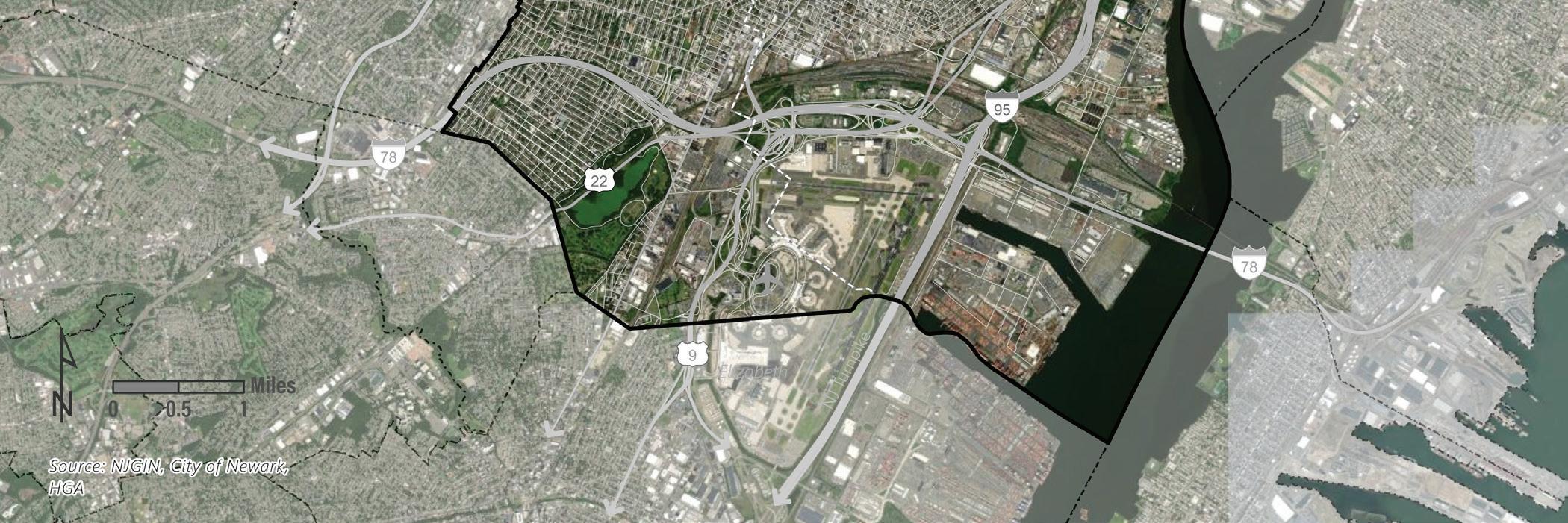
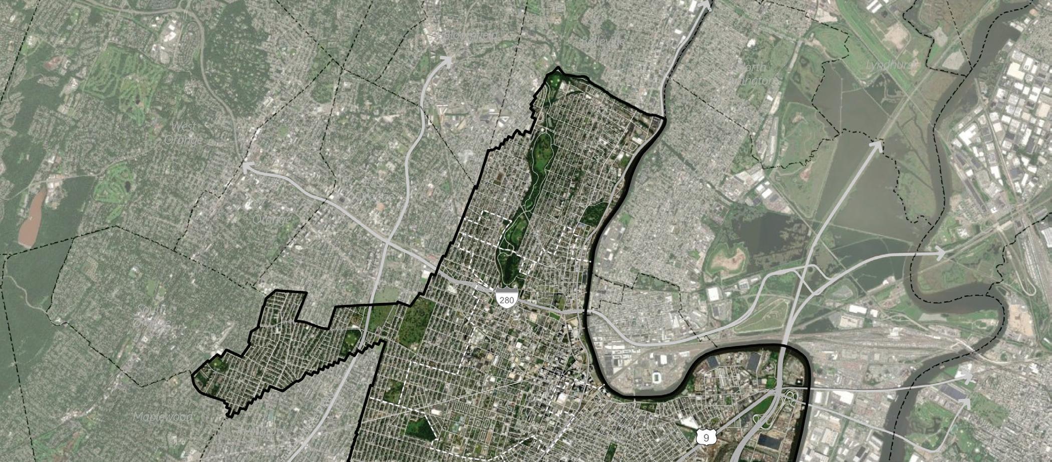 Figure 1 Aerial Image of Newark, prepared by HGA
4 | Appendix I.
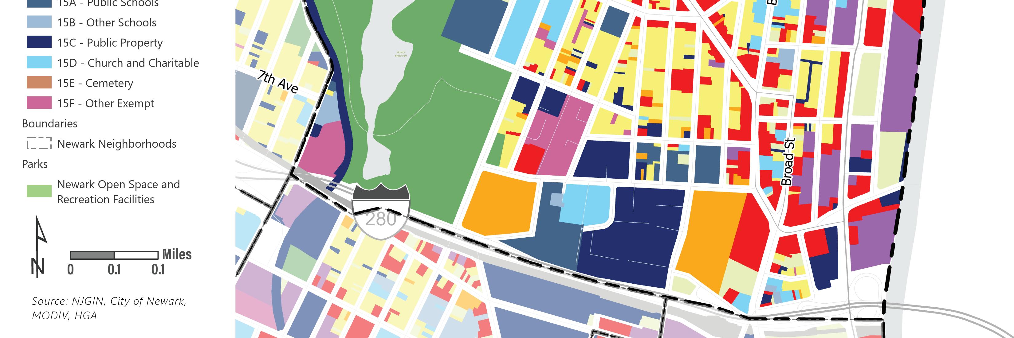
Today, the city is highly urbanized with limited open space, tree cover, and pervious surface. Few areas of the city remain in a natural state. Branch Brook Park, running from the city’s northern border with Belleville south to Interstate 280, and Weequahic Park, located at the city’s southern border with Hillside just east of Newark Liberty International Airport are the city’s major green spaces.
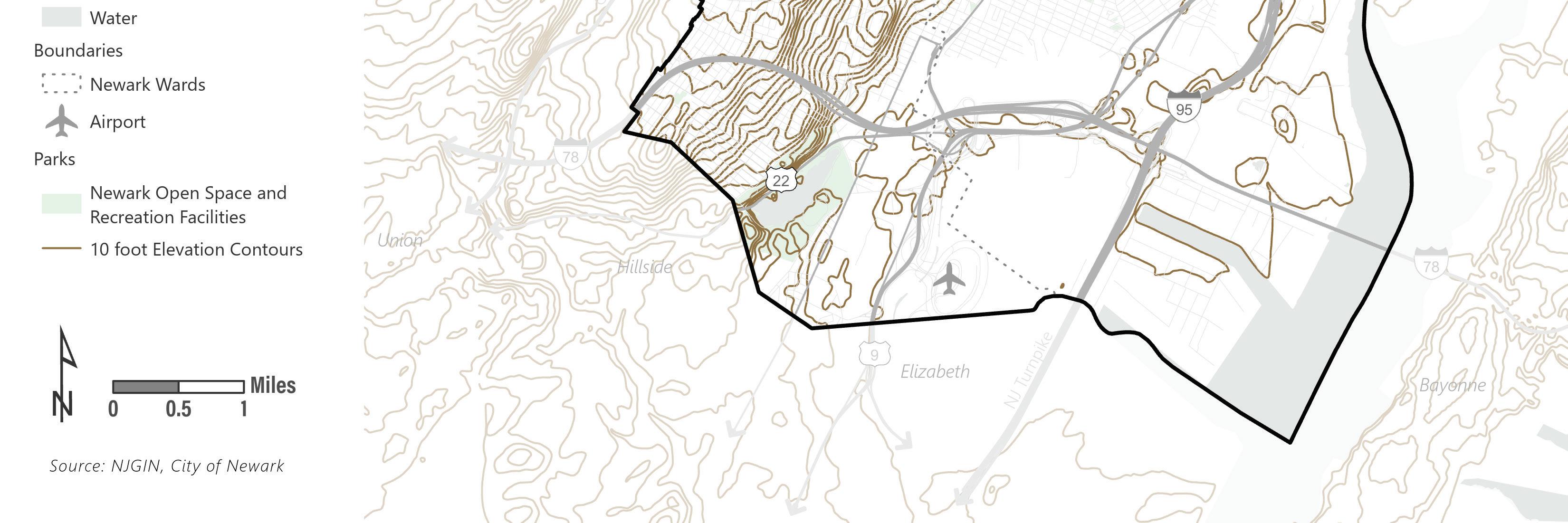
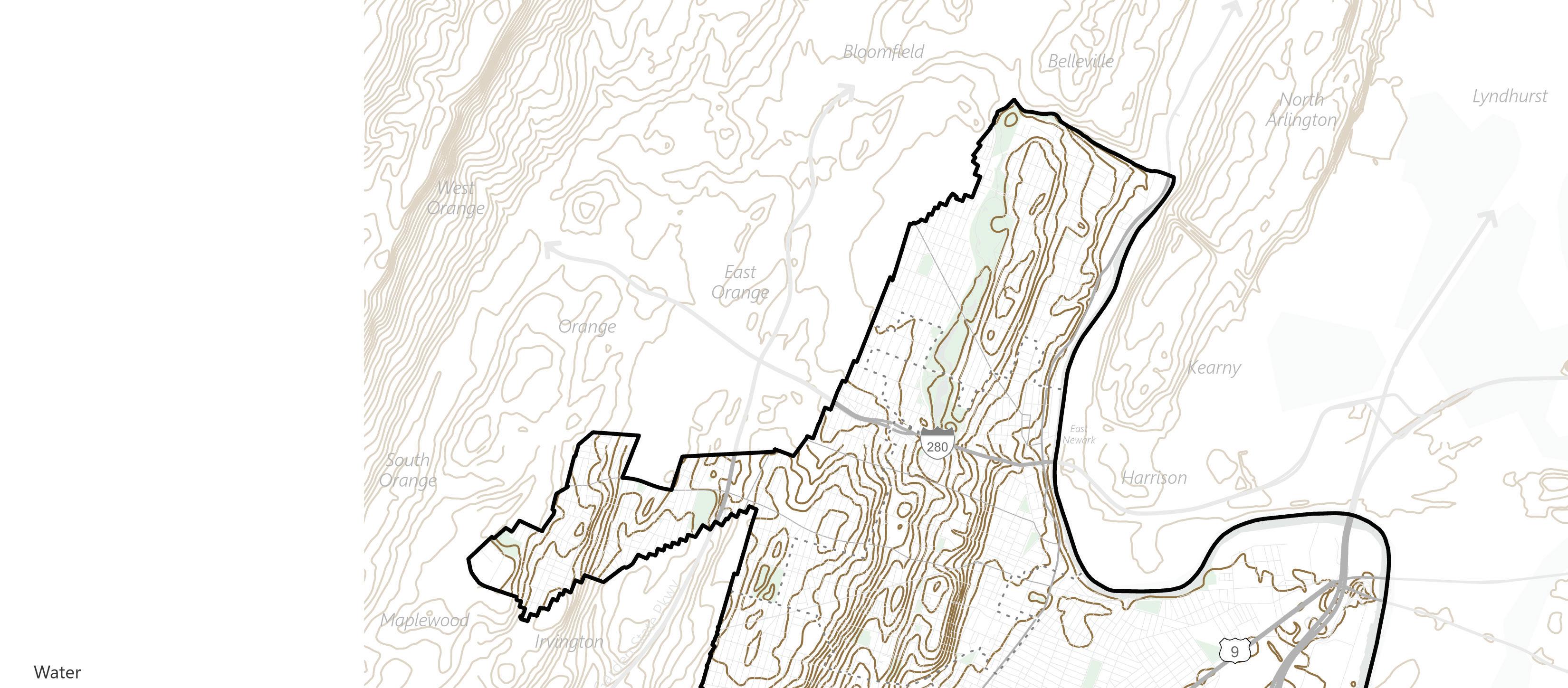 Figure 2
Topographic Map 10' contour intervals prepared by HGA
Figure 2
Topographic Map 10' contour intervals prepared by HGA
Open Space 10 ft Elevation Contours Topography Land Use Element | 5
Built Environment
The city’s built environment ranges from high rises downtown that reflect different eras of development and redevelopment, to neighborhood commercial corridors radiating like spokes in a wheel from the heart of the city, to quiet residential neighborhoods in the north, west, and south wards, to the vibrant and dense mixed-use Ironbound neighborhood, to the industrial port and airport waterfront. The building stock in Newark comprises many historic buildings and homes developed in the 19th and early 20th centuries.
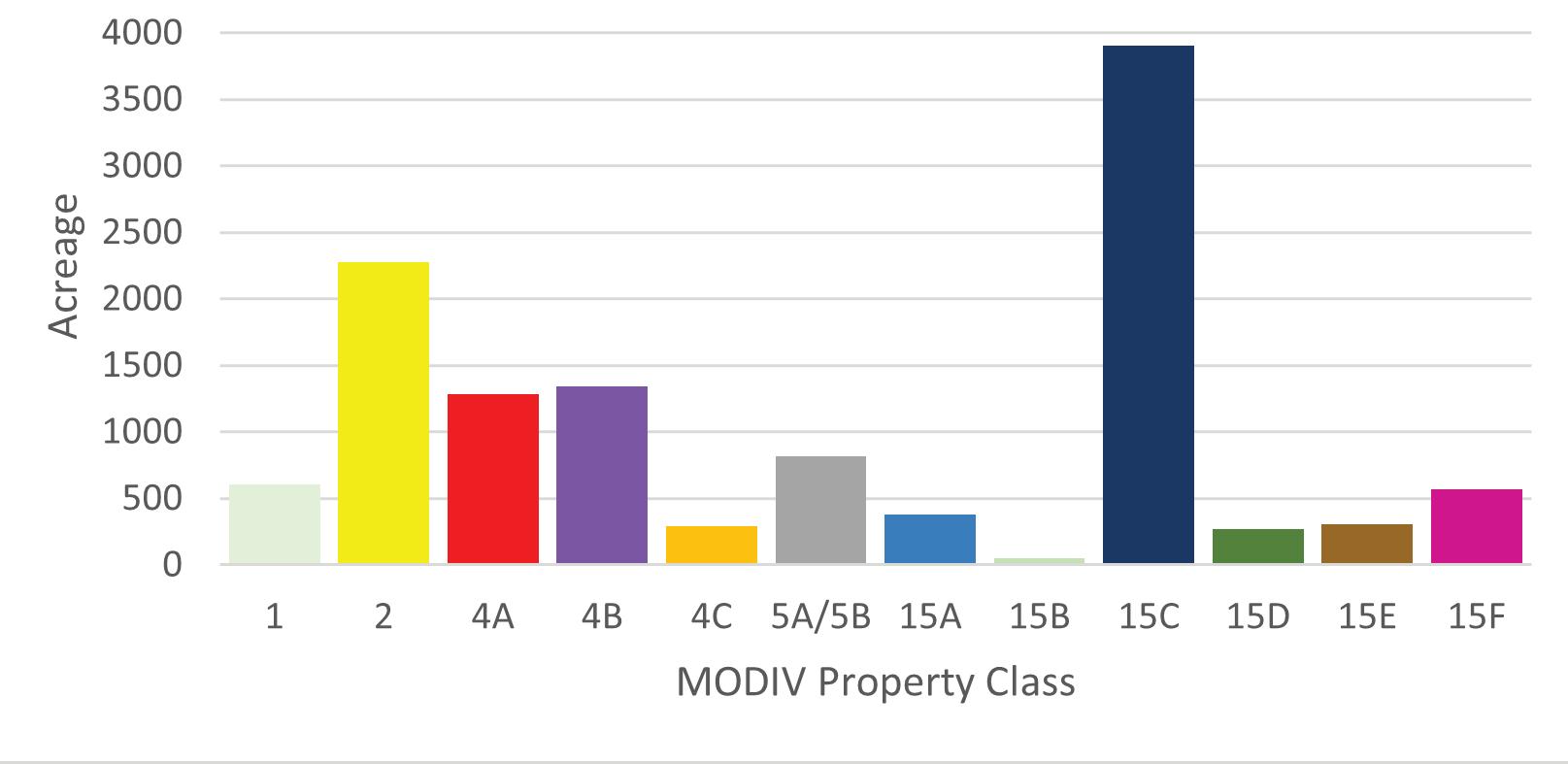
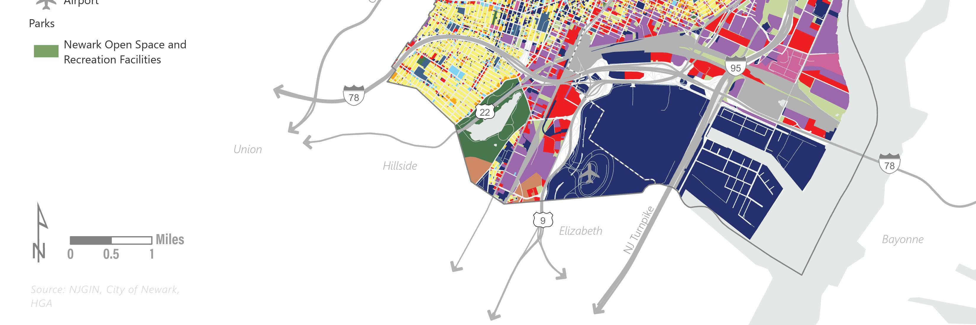
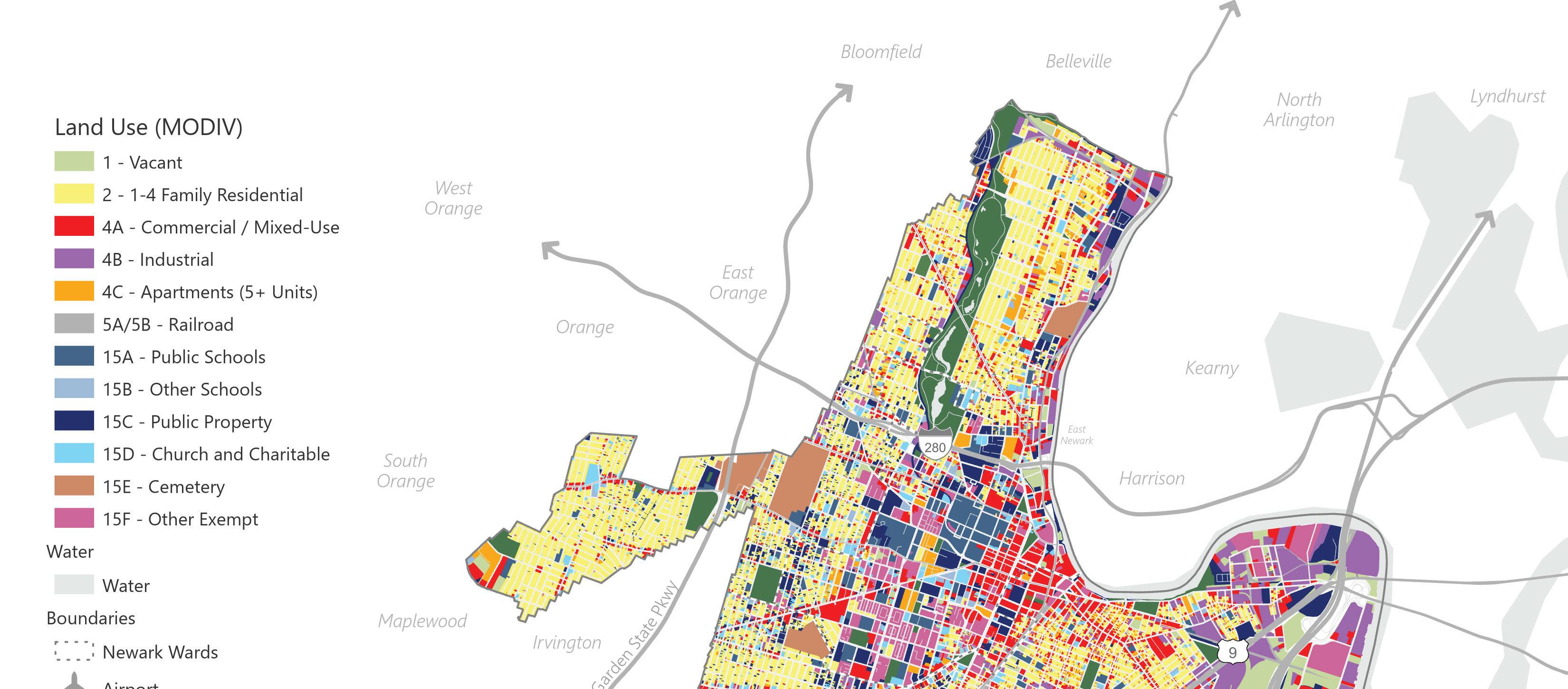
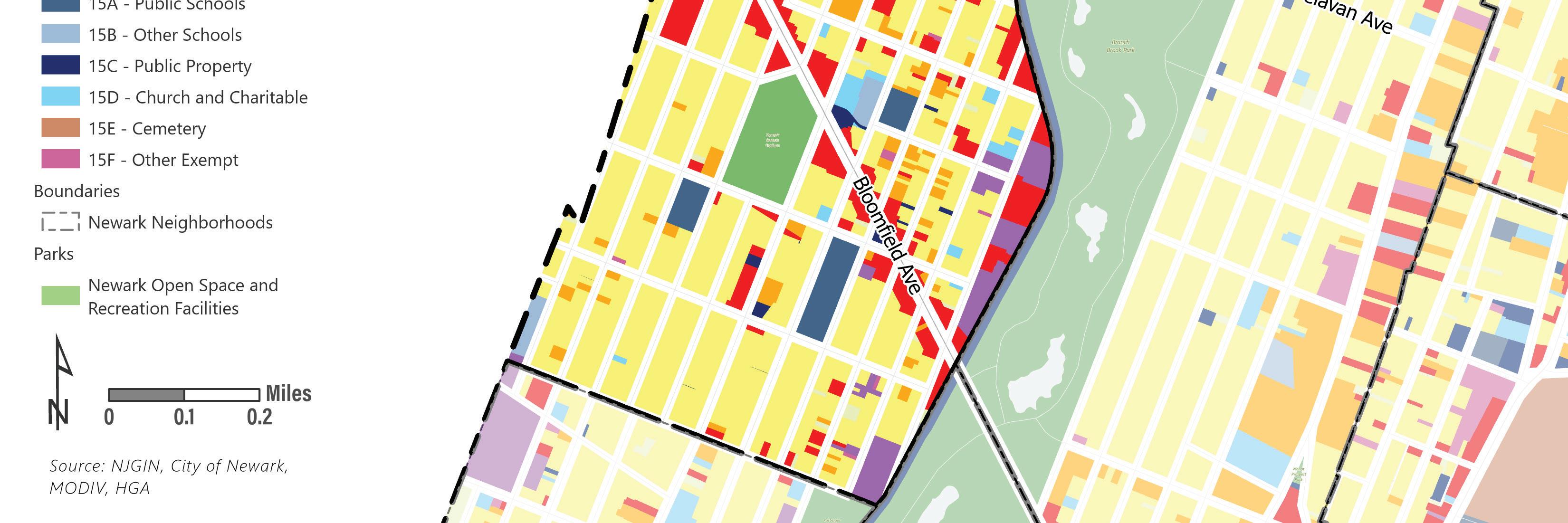
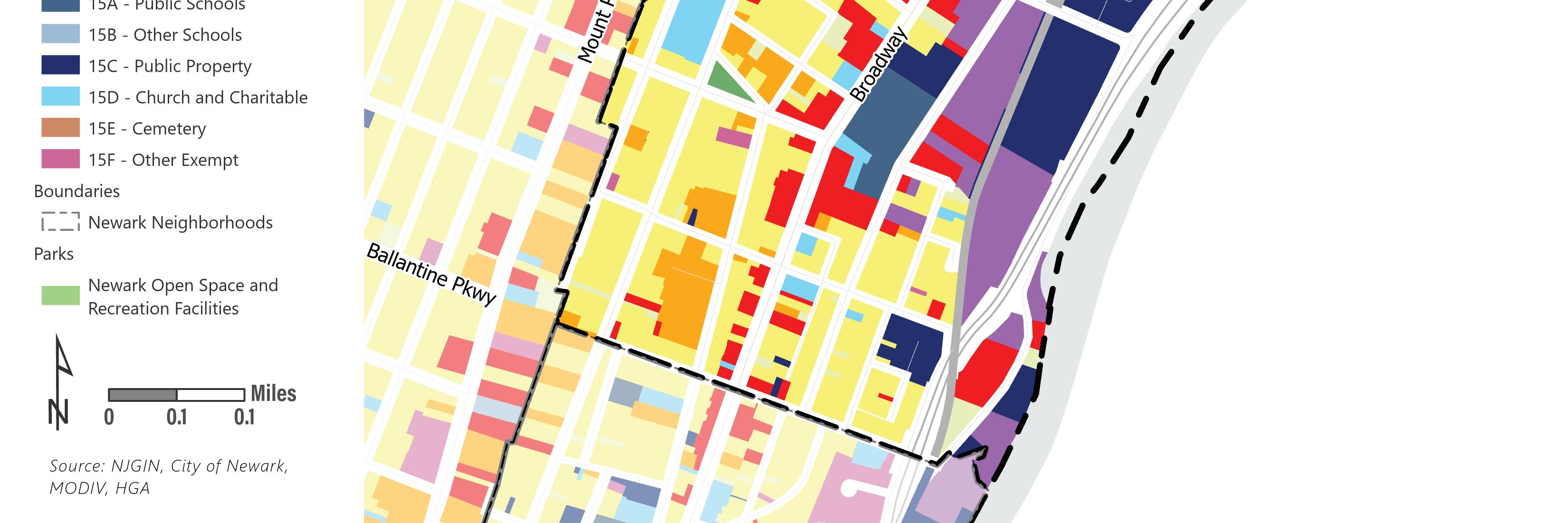
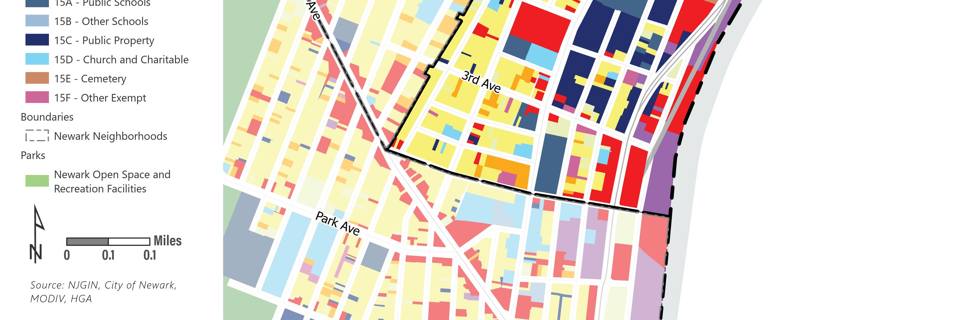
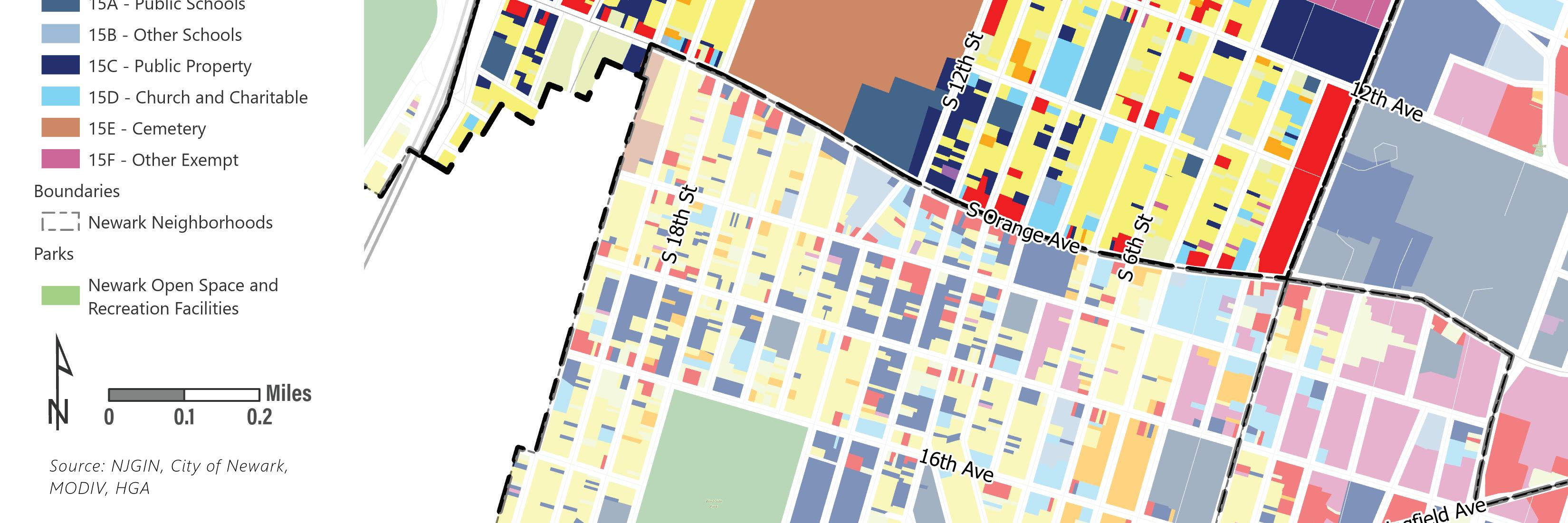
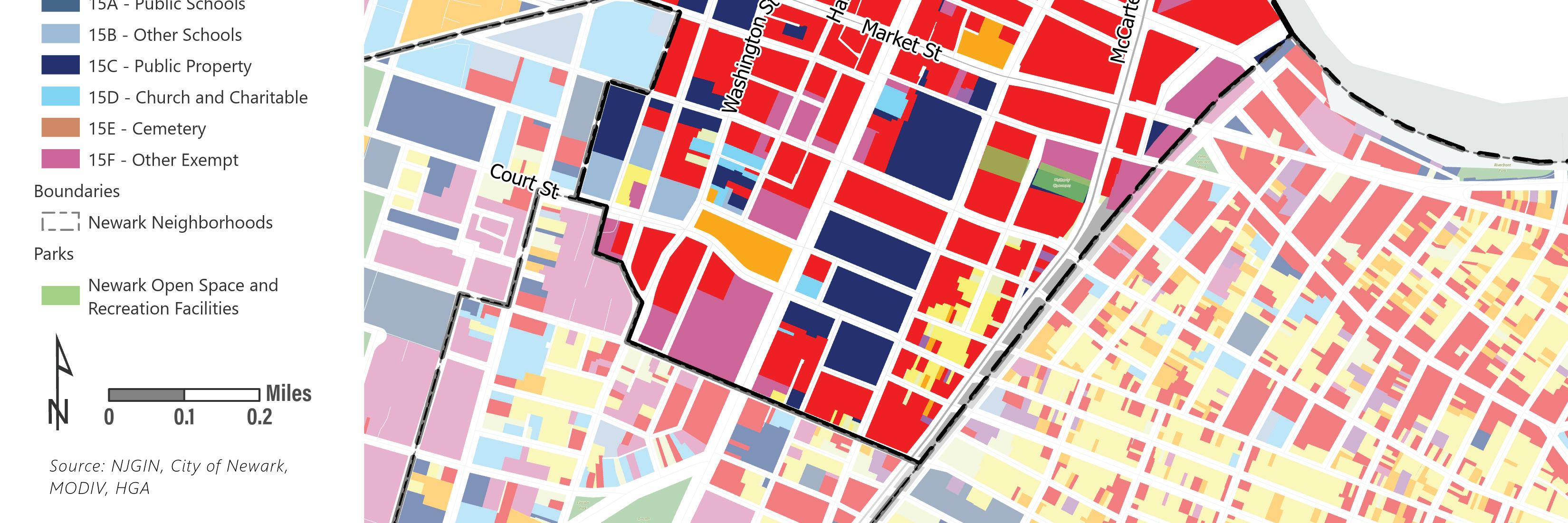
Figure 3 shows the spatial distribution of existing land uses throughout the city as defined by taxation records. Lower density residential neighborhoods, seen in yellow, predominate in the North, South, and West Wards of the city. The central business district and commercial corridors are defined as red areas. The industrial portions of the city in the south and east ward are shown in purple. Large swaths of publicly owned land, which include parks, Newark Liberty International Airport, and Port Newark are dark blue.
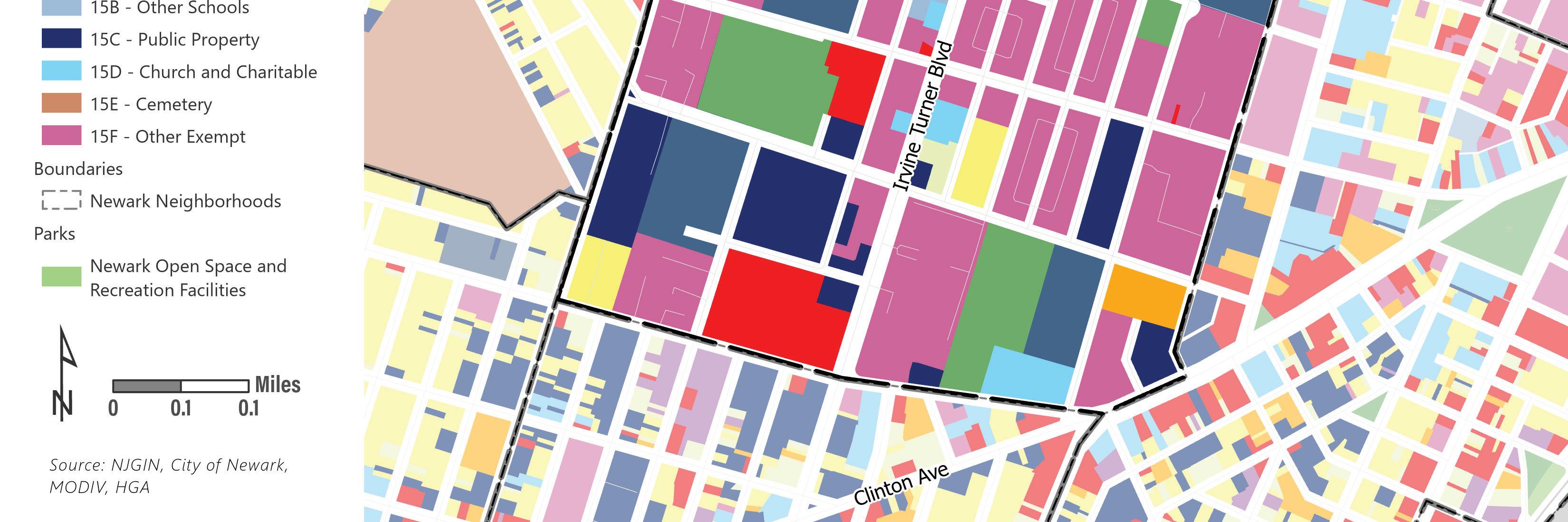
The pink-purple color (Class 15F “Other Exempt”) is dominant in the central ward and within current and former redevelopment areas. Properties classified as 15F are often those subject to payments in lieu of taxes, or other tax abatements. These types of incentives may be provided to redevelopment projects. Many of the areas shown as “Other Exempt” in the central ward are either residential or mixed-use developments that are currently making payments in lieu of taxes. There are also several industrial developments in the East Ward identified as “Other Exempt.”
Existing Land Use1 Acreage Percentage of City
1 - Vacant Land 604.9 5.0%
2 - Residential (1-4 Units) 2,278.70 18.8%
4A - Commercial / Mixed-Use 1,283.30 10.6%
4B - Industrial 1,345.80 11.1%
4C - Apartments (5+ Units) 292.8 2.4%
5A/5B - Railroad 815.4 6.7%
15A - Public Schools 380.3 3.1%
15B - Other Schools 51.9 0.4%
15C - Public Property 3,906.30 32.3%
15D - Church and Charitable 270.4 2.2%
15E - Cemetery 303.9 2.5%
15F - Other Tax-Exempt Property 567.7 4.7%
• 1 - Existing land use is derived from ArcGIS parcel data and MOD-IV tax assessment records. MOD-IV is a standardized system used throughout New Jersey to provide uniform recording and storage of tax records. One of the fields in the tax data is “Property Class” which classifies the property for taxation purposes based on its use and/or ownership.
EXISTING LAND USE
6 | Appendix I.
Land
 Figure
3 Existing Land Use Map based on MODIV tax data, prepared by HGA Vacant 1-4 Family Residential Commercial/Mixed-use Industrial Apartments (5+ units) Railroad Public Schools Other Schools Public Property Church and Charitable Cemetery Other Exempt Open Space
Use (MODIV) Land Use Element | 7
NEIGHBORHOODS
Newark is divided into five political wards, and twenty informal neighborhoods.
Neighborhood divisions are based on history, geography, topography, land use, and culture. The city is physically and ethnically diverse, with the diversity reflected in the distinct character of its neighborhoods.
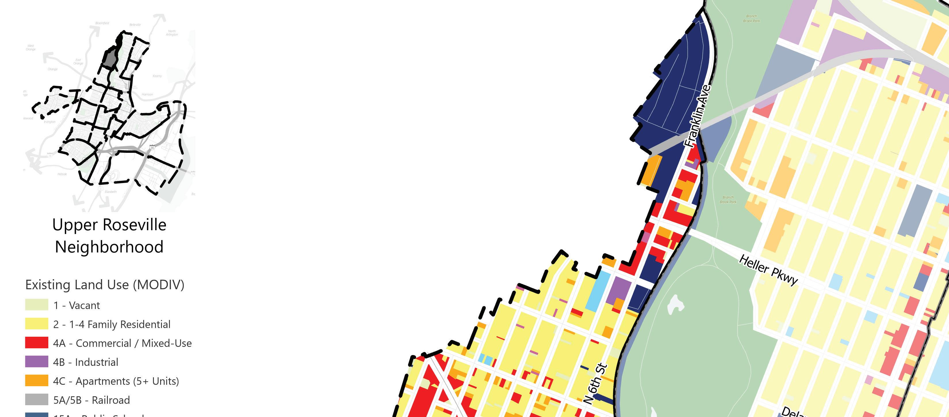
Upper Roseville
The Upper Roseville neighborhood is in the western section of Newark’s North Ward adjacent to the municipal boundary between Newark and the city of East Orange. The edges of the neighborhood are defined by Franklin Avenue, Branch Brook Park, and 3rd Avenue. The neighborhood is largely residential with commercial clusters in the northern section and along Bloomfield Avenue. Bloomfield Avenue has a mix of retail and small office uses in mixed-use buildings. Newark’s light rail runs along the eastern boundary of the neighborhood alongside Branch Brook Park, connecting Upper Roseville to Downtown Newark. In addition to neighboring Branch Brook Park, Upper Roseville has Savlatore Bontempo Memorial Park and St. Francis Park along Bloomfield Avenue.
Land Use (MODIV)
Vacant
1-4 Family Residential Commercial/Mixed-use
Industrial
Apartments (5+ units)
Railroad Public Schools
Other Schools
Public Property
Church and Charitable Cemetery
Other Exempt
Open Space
8 | Appendix I.
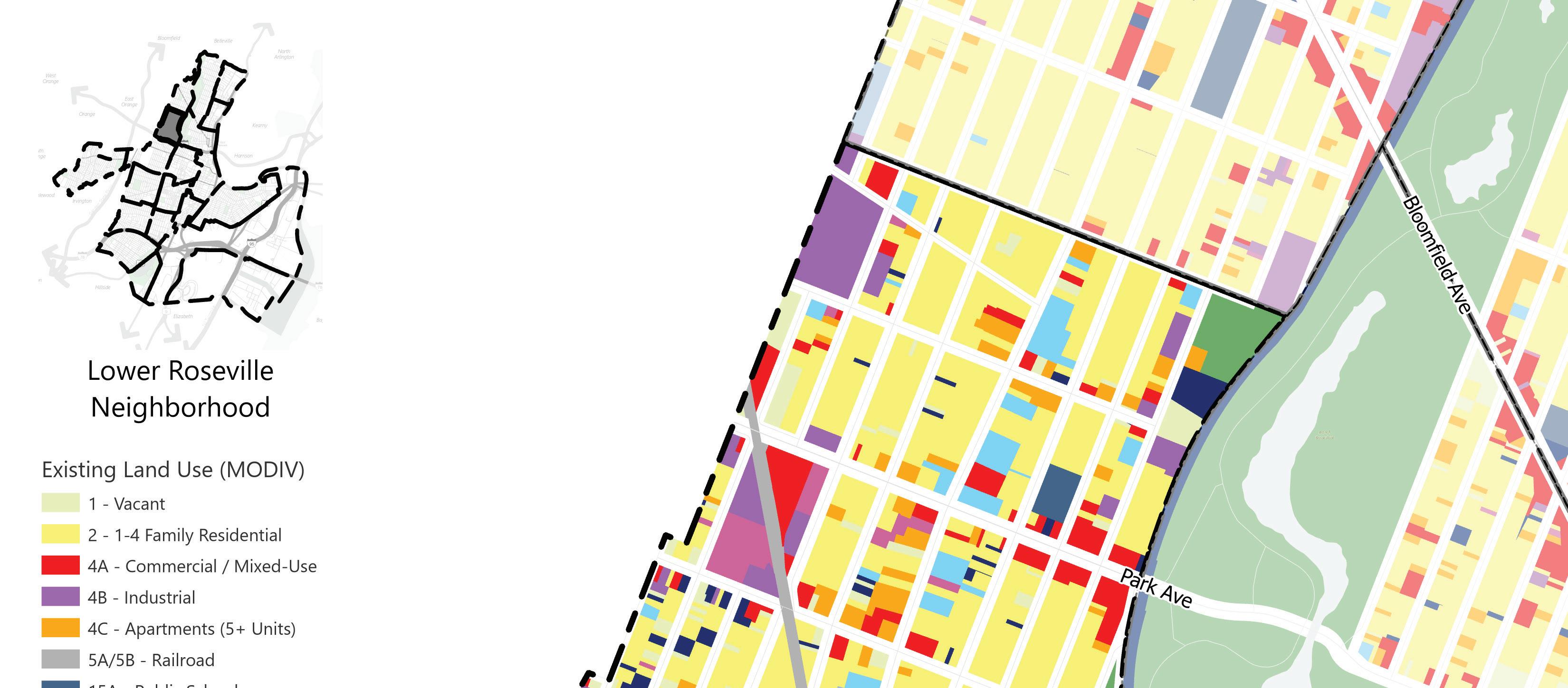
Lower Roseville
Lower Roseville is partially in Newark’s North, West, and Central Wards. The boundaries of the neighborhood are the municipal boundary between Newark and the city of East Orange to the west, 3rd Avenue to the north, Branch Brook Park to the east, and Interstate 280 to the south. Lower Roseville is a mixed-use neighborhood with two commercial corridors along Orange Street and Park Avenue. The neighborhood has a wide range of residential uses including, one- and twofamily homes and low-, mid-, and high-rise multifamily buildings. The Lower Roseville neighborhood has three parks, Kasberger Field, 1st Street Park, and Thomas Silk Park, in addition to neighboring Branch Brook Park.
Land Use (MODIV)
Vacant
1-4 Family Residential Commercial/Mixed-use Industrial
Apartments (5+ units)
Railroad Public Schools
Other Schools
Public Property Church and Charitable Cemetery
Other Exempt
Open Space
Land Use Element | 9
Land Use (MODIV)

Vacant
1-4 Family Residential Commercial/Mixed-use
Industrial
Apartments (5+ units)
Railroad Public Schools
Other Schools
Public Property
Church and Charitable Cemetery
Other Exempt
Open Space
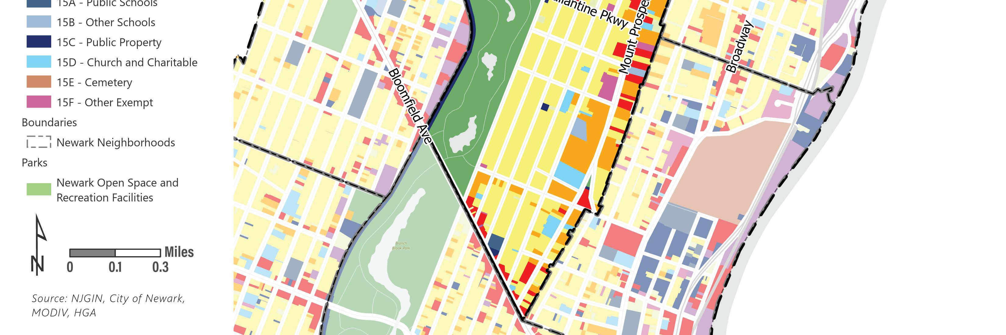
Forest Hill
The Forest Hill neighborhood is in the Newark’s North Ward bounded by the Newark and Township of Belleville municipal line to the north, generally along Mount Prospect Avenue and Woodside Avenue to the east, Bloomfield Avenue to the South, and the Newark Light Rail to the west. The neighborhood is primarily single-family residential homes with a few vacant and industrial properties in the northern section along Elwood Avenue East and mixed-use properties along Mount Prospect Avenue. The northern half of Branch Brook Park stretches across the entirety of the Forest Hill neighborhood’s western boundary, providing ample open space. The Forest Hill neighborhood contains the Forest Hill Historic District.
10 | Appendix I.
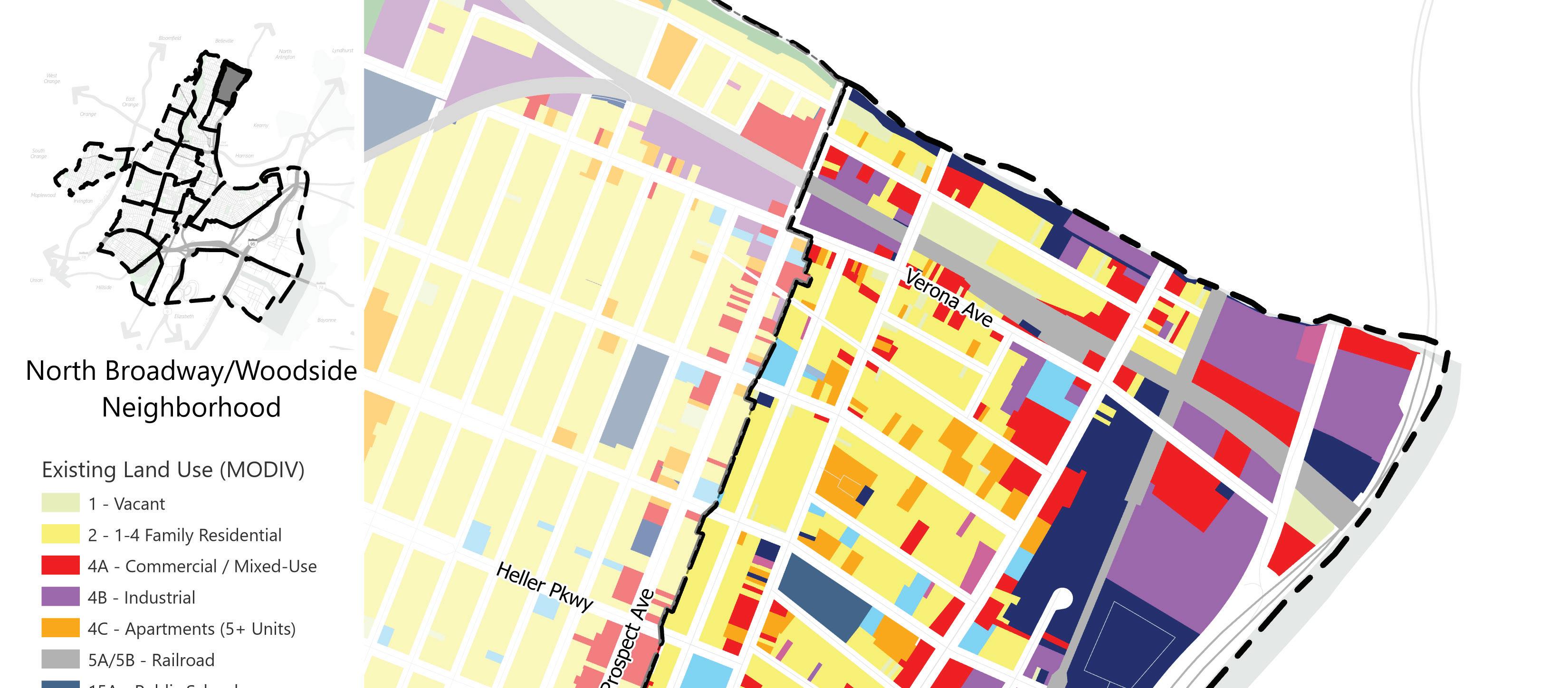
North Broadway / Woodside
The North Broadway / Woodside neighborhood in Newark’s North Ward. The neighborhood boundaries are generally along Mount Prospect Avenue and Woodside Avenue to the west, Newark and Township of Belleville municipal boundary to the north, Passaic River to the east, and Chester Avenue to the south. There is industrial development on the eastern side of the neighborhood along the Passaic River. Commercial development in the neighborhood is concentrated along Broadway. The western and southern areas are largely residential with a combination of oneand two-family homes and multifamily residential. The riverfront properties in the southeastern corner of the neighborhood are in the Riverfront Public Access and Redevelopment Plan area. Phillips Park is the only park in the North Broadway / Woodside neighborhood.
Land Use (MODIV)
Vacant
1-4 Family Residential Commercial/Mixed-use Industrial
Apartments (5+ units)
Railroad Public Schools
Other Schools
Public Property Church and Charitable Cemetery
Other Exempt
Open Space
Land Use Element | 11
Land Use (MODIV)
Vacant
1-4 Family Residential
Commercial/Mixed-use
Industrial
Apartments (5+ units)
Railroad Public Schools
Other Schools
Public Property
Church and Charitable
Cemetery
Other Exempt
Open Space
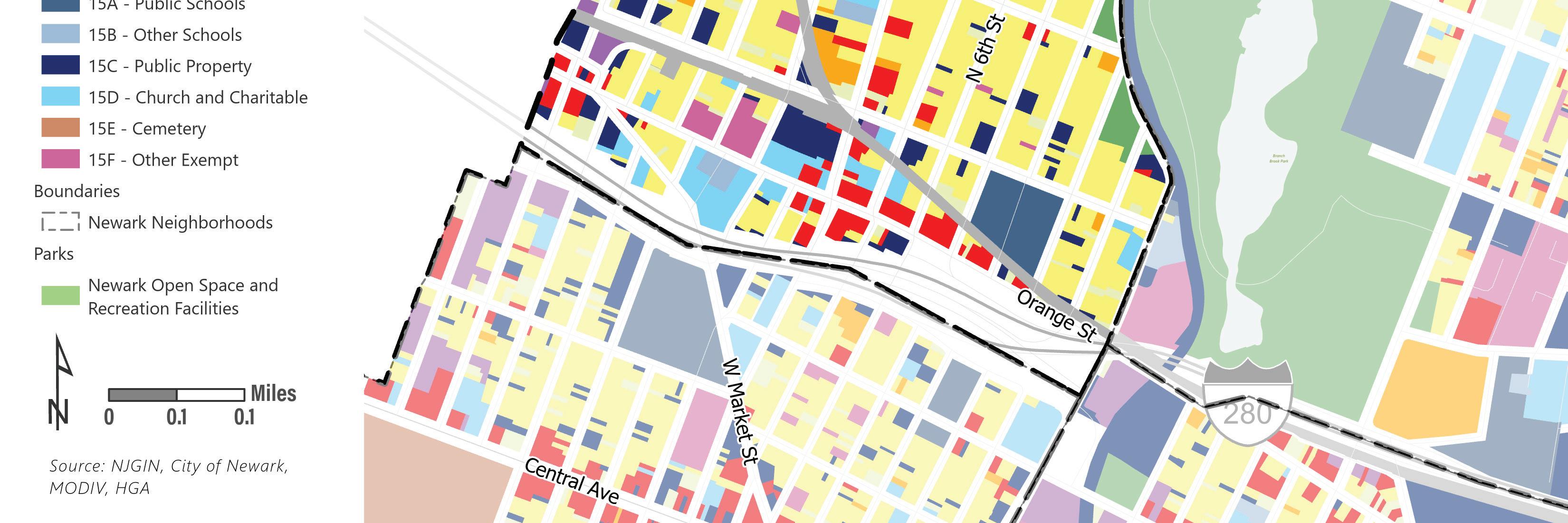
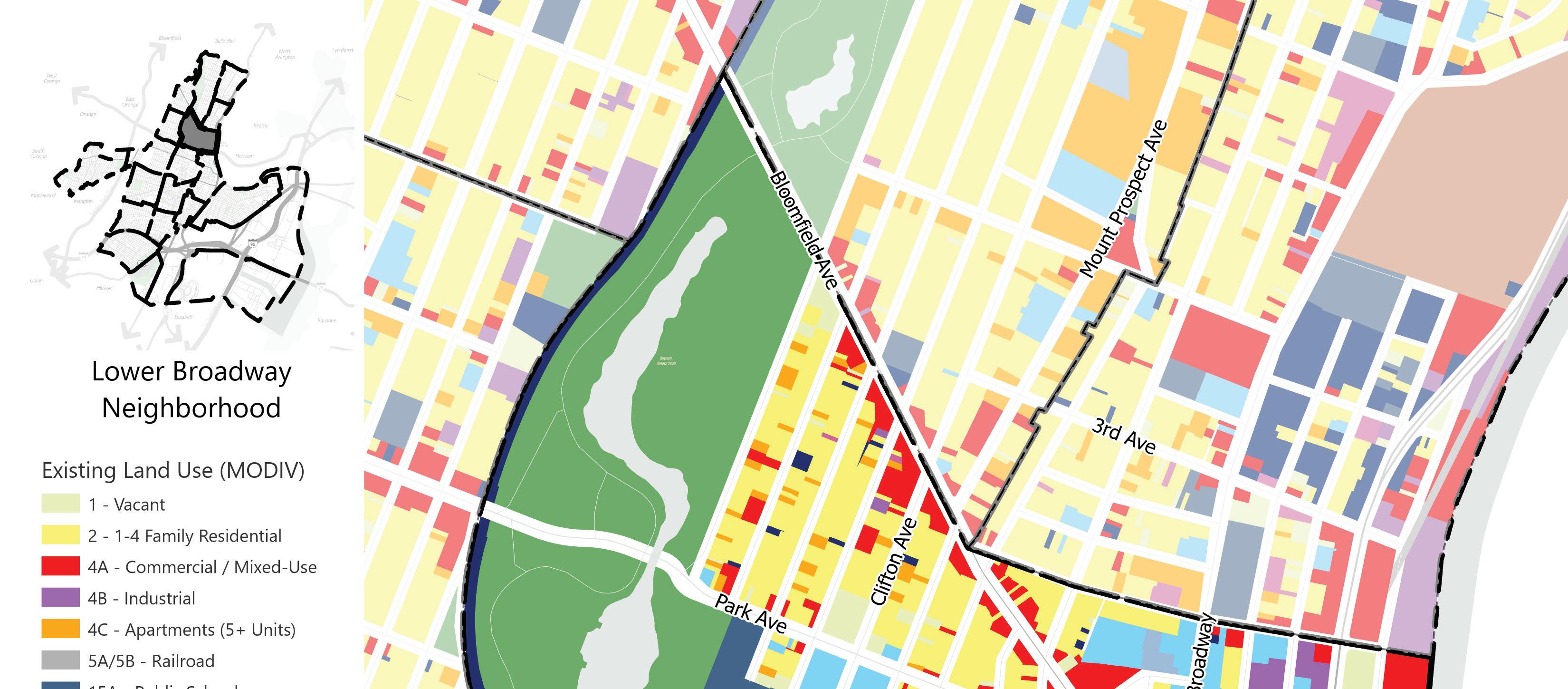
Lower Broadway
The Lower Broadway neighborhood is in Newark’s North and Central wards and bounded by Bloomfield Avenue and 4th Avenue to the north, the Passaic River to the east, Interstate 280 to the south, and the Newark Light Rail to the west. The neighborhood is largely residential with industrial and commercial uses along the Passaic River and commercial uses along Bloomfield Avenue and Broad Street. The southern section of Branch Brook Park provides open space for the neighborhood. The Riverfront Public Access and Redevelopment Plan areas encompasses the neighborhood’s properties east of Mount Pleasant Avenue along the Passaic River.
12 | Appendix I.
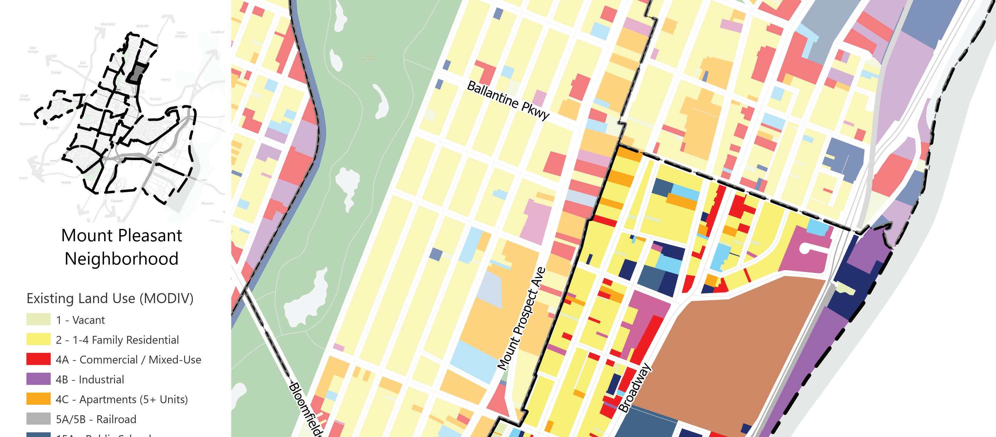
Mount Pleasant
The Mount Pleasant neighborhood is in Newark’s North and Central Wards. The boundaries of the neighborhood are Chester Avenue to the north, the Passaic River to the east, 4th Avenue to the South, and mid-block between Mount Prospect Avenue and Garside Street or Woodside Avenue to the west. The neighborhood is primarily residential with mostly two- and three-family homes. There are numerous vacant properties, and infill development has led to some commercial properties scattered throughout the neighborhood. Mount Pleasant Cemetery is a fixture in the neighborhood that is the burial site for many notable Newark citizens and provides open space to the neighborhood. The Riverfront Public Access and Redevelopment Plan areas encompasses the neighborhood’s properties near the Passaic River.
Land Use (MODIV)
Vacant
1-4 Family Residential Commercial/Mixed-use Industrial
Apartments (5+ units)
Railroad Public Schools
Other Schools
Public Property Church and Charitable Cemetery
Other Exempt Open Space
Land Use Element | 13
Land Use (MODIV)
Vacant
1-4 Family Residential Commercial/Mixed-use
Industrial
Apartments (5+ units)
Railroad Public Schools Other Schools
Public Property Church and Charitable Cemetery
Other Exempt
Open Space
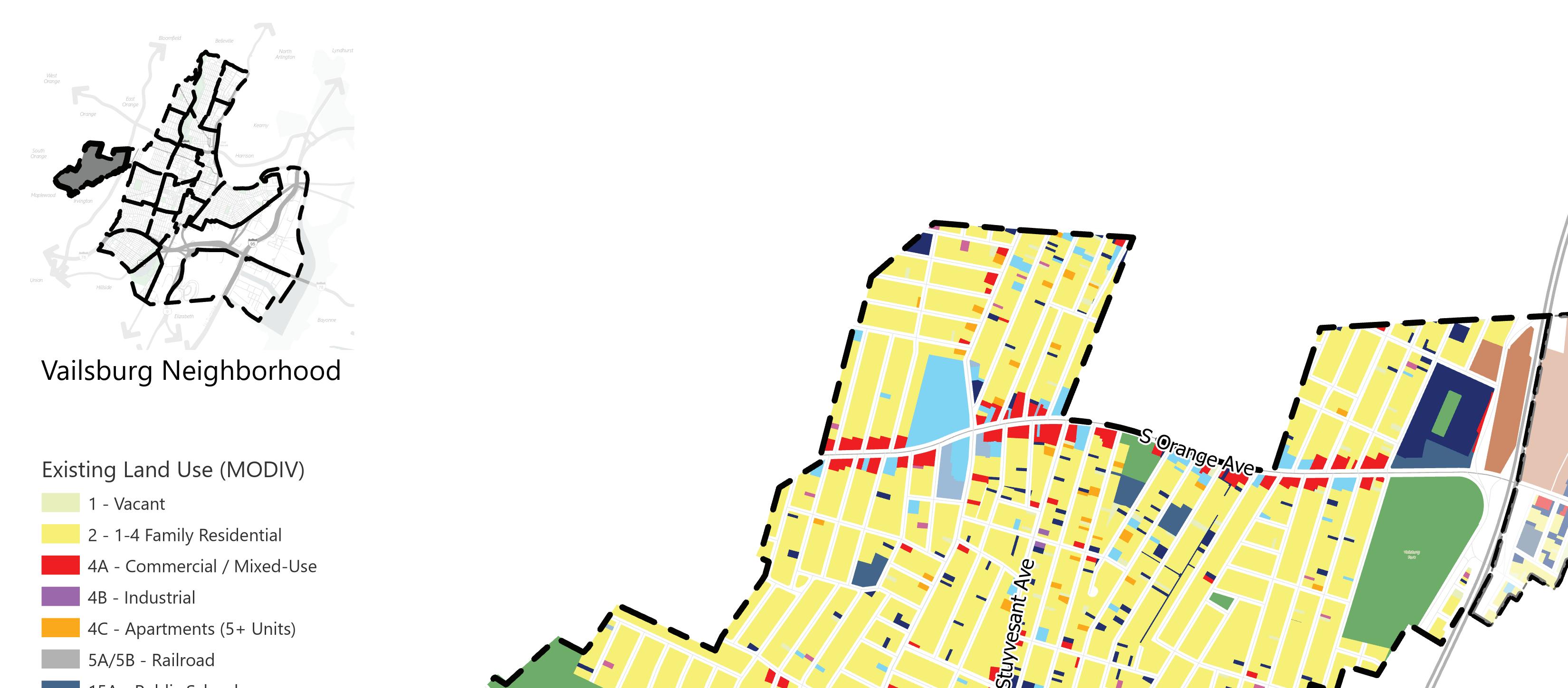
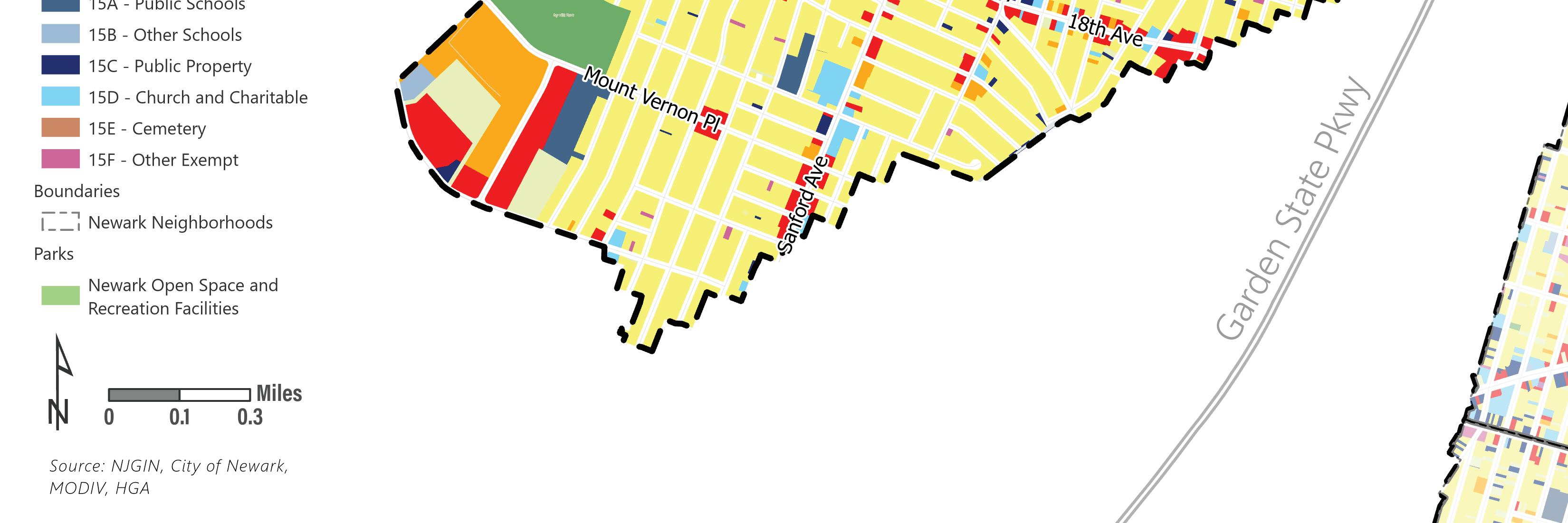
Vailsburg
The Vailsburg neighborhood is Newark’s westernmost neighborhood. The boundaries of the neighborhood are the Newark and City of East Orange municipal boundary to the north, the Garden State Parkway to the east, the Newark and Irvington Township and Newark and Maplewood Township municipal boundaries to the south, and the Newark and South Orange Township municipal boundary to the west. The neighborhood is primarily one- and two-family residential homes with a pocket of low-, mid-, and high-rise multifamily residential properties at the western edge of the neighborhood. Commercial development is concentrated along South Orange Avenue that connects Valisburg to the rest of Newark, with additional commercial uses along Sanford Avenue and 18th Avenue. There are two parks in the neighborhood, Ivy Hill Park and Vailsburg Park.
14 | Appendix I.
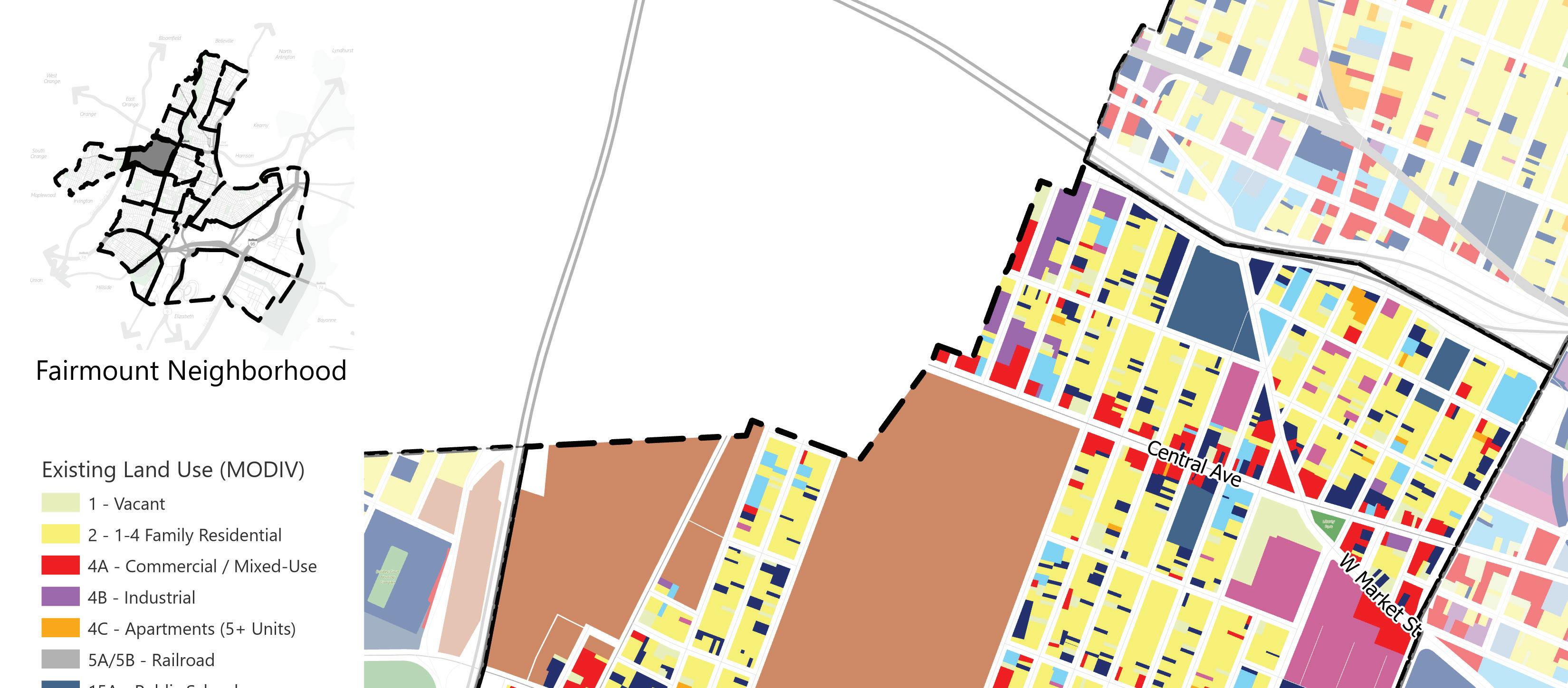
Fairmount
The Fairmount neighborhood is in Newark’s West Ward and is bounded by the Newark and City of East Orange municipal boundary and Interstate 280 to the north, Bergen Street and 1st Street to the east, the Newark and Irvington Township municipal boundary and South Orange Avenue to the south, and the Garden State Parkway to the west. The neighborhood is a mixed-use neighborhood with a variety of residential housing types ranging from single-family homes to high-rise multifamily buildings. The neighborhood’s primary commercial corridor is Central Avenue, which runs east to west across the neighborhood. Fairmount has two cemeteries, the Holy Sepulchre Cemetery and Fairmount Cemetery, that occupy one quarter of the neighborhood’s land area. Liberty Park is a small park and the only park in the Fairmount neighborhood.
Land Use (MODIV)
Vacant
1-4 Family Residential Commercial/Mixed-use Industrial Apartments (5+ units)
Railroad Public Schools
Other Schools
Public Property Church and Charitable Cemetery
Other Exempt
Open Space
Land Use Element | 15
Land Use (MODIV)
Vacant
1-4 Family Residential Commercial/Mixed-use Industrial
Apartments (5+ units)
Railroad Public Schools
Other Schools
Public Property Church and Charitable Cemetery
Other Exempt
Open Space
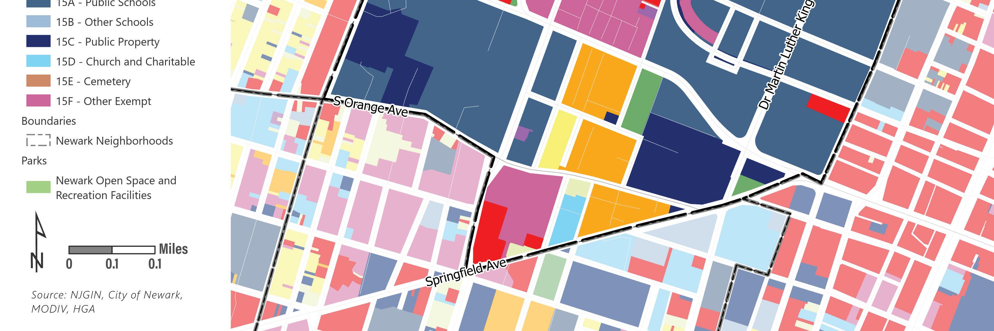
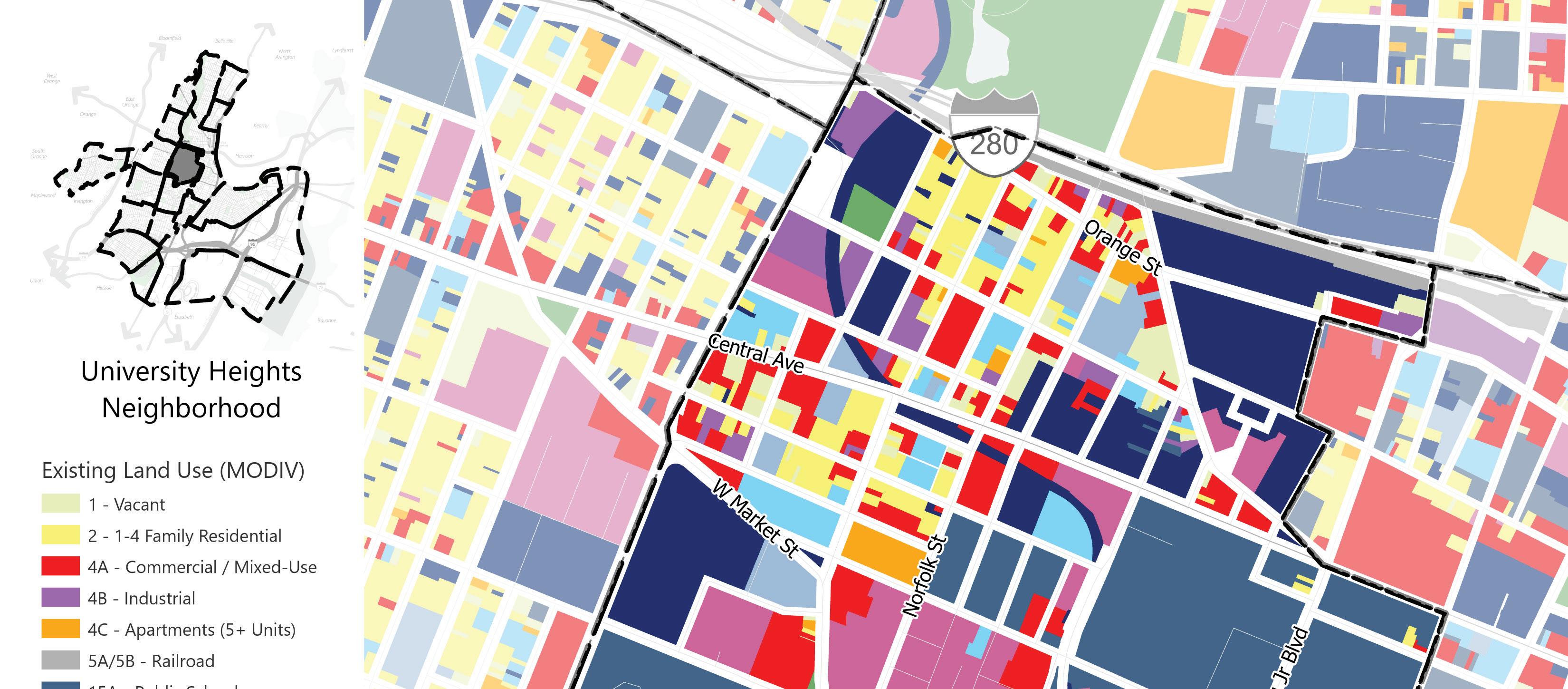
University Heights
The University Heights neighborhood is in Newark’s Central Ward. The neighborhood boundaries are Interstate 280 to the north, University Avenue, Summit Street, Boyden Street, and Martin Luther King Jr. Boulevard to the east, South Orange Avenue and Springfield Avenue to the south, and Bergen Street and 1st Street to the west. The neighborhood is home to several institutions of higher education, including Rutgers University-Newark, the New Jersey Institute of Technology, and Essex County Community College. The northern corner of the neighborhood is mixed-use with residential, commercial, and industrial properties. Open space in University Heights is provided by two parks, Boys Park and Sussex Park, and the green space on the university campuses.
16 | Appendix I.
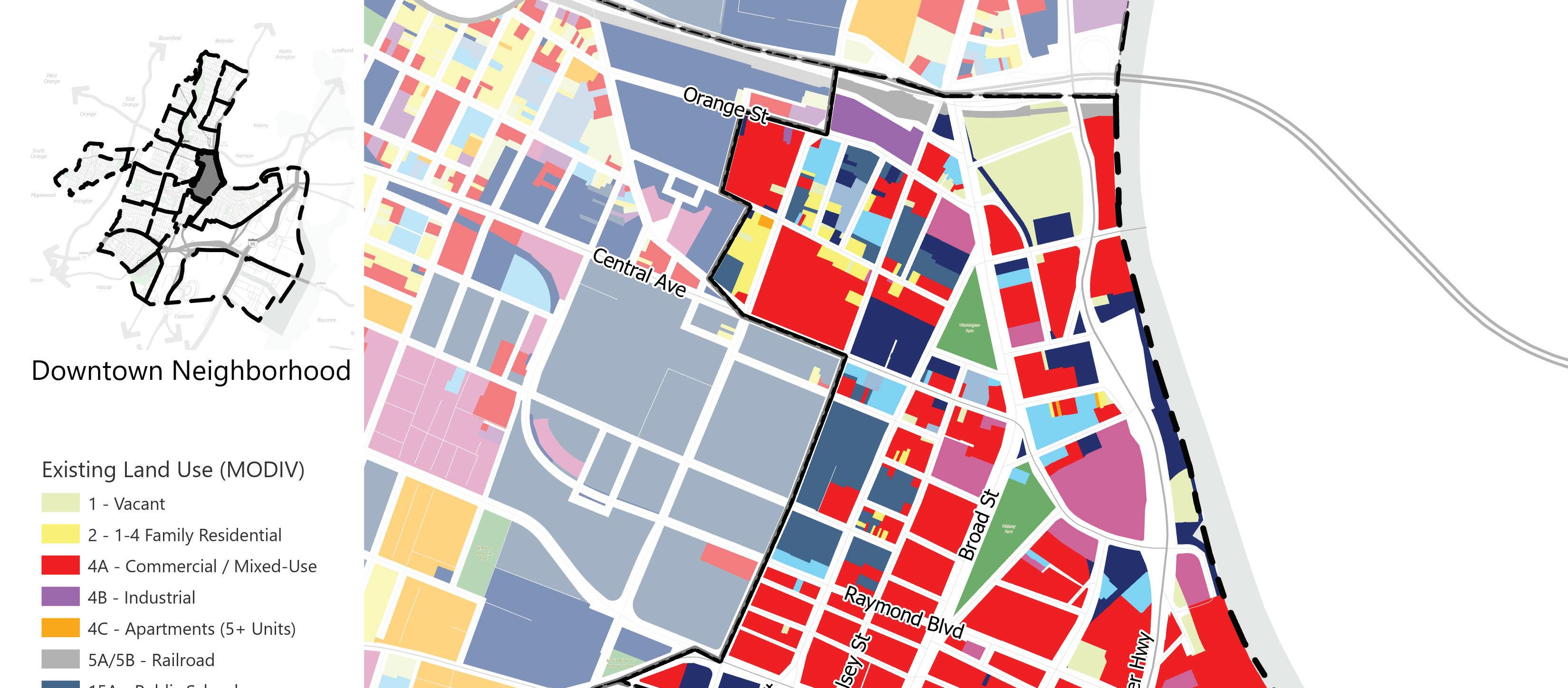
Downtown
Downtown is in Newark’s Central Ward bounded by Orange Street and Interstate 280 to the north, the Passaic River and McCarter Highway to the east, Court Street and Kinney Street to the south, and University Avenue, Summit Street, Boyden Street, and Martin Luther King Jr. Boulevard to the west. Downtown is the commercial hub of the city centered on “Four Corners” at the intersection of Broad Street and Market Street. Both Broad and Market Streets are lined with commercial uses. Downtown has four historic districts: James Streets Commons, Four Corners Historic District, Military Park Historic District, and the Lincoln Park Historic District. Multiple redevelopment districts encompass areas of Downtown in efforts to revitalize the area as there are numerous vacant properties. There are several parks in Downtown, including Military Park and Harriet Tubman Park found along Broad Street.
Land Use (MODIV)
Vacant
1-4 Family Residential Commercial/Mixed-use Industrial Apartments (5+ units)
Railroad Public Schools Other Schools
Public Property Church and Charitable Cemetery
Other Exempt
Open Space
Land Use Element | 17
Land Use (MODIV)
Vacant
1-4 Family Residential Commercial/Mixed-use
Industrial
Apartments (5+ units)
Railroad Public Schools
Other Schools
Public Property
Church and Charitable Cemetery
Other Exempt
Open Space
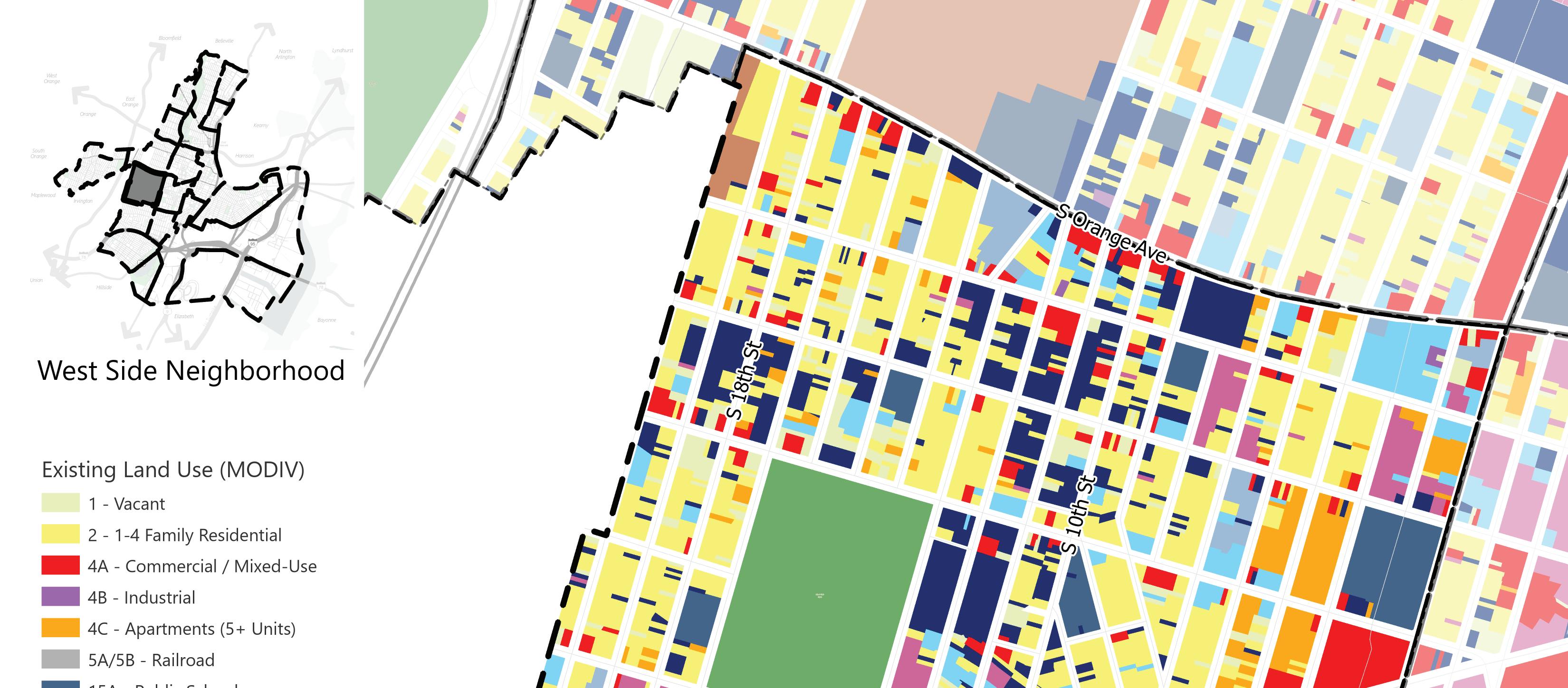
West Side
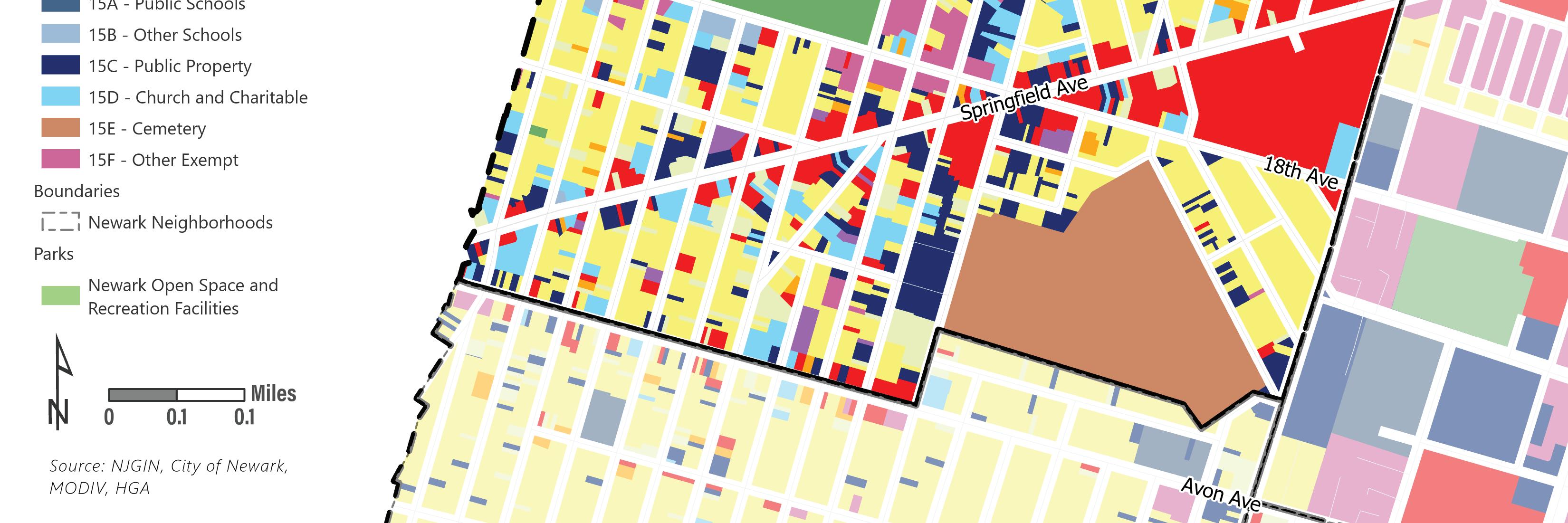
The West Side neighborhood is in Newark’s West, Central and South Wards. The neighborhood boundaries are South Orange Avenue to the north, Bergen Street to the east, Avon Avenue and Woodland Cemetery to the south, and the Newark and Irvington Township municipal boundary to the west. The neighborhood is largely a mix of residential buildings and vacant and abandoned properties. Most of West Side’s commercial properties are concentrated along Springfield Avenue. The West Side neighborhood has access to open space through the West Side Park. The Kent/ Brenner/Springfield Redevelopment Plan areas encompasses a large portion of the West Side neighborhood.
18 | Appendix I.
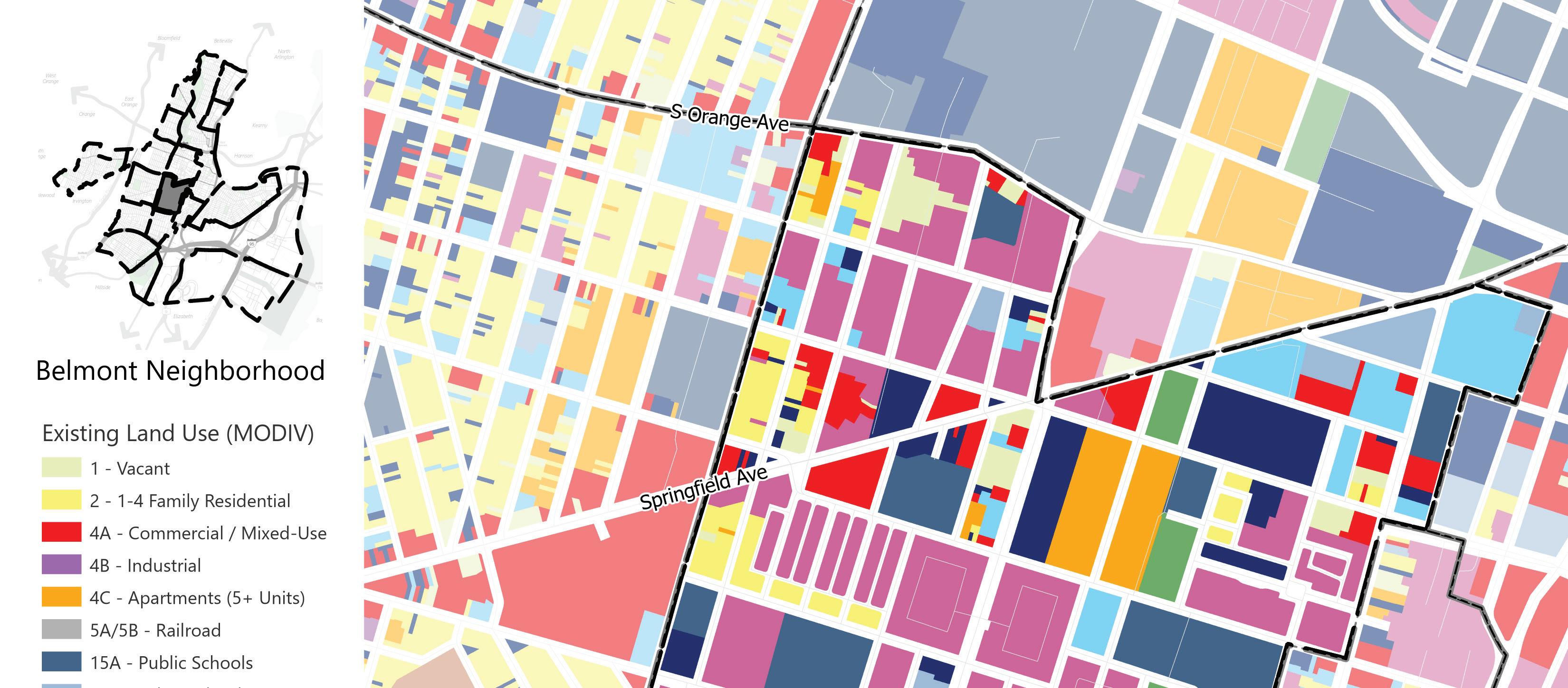
Belmont
The Belmont neighborhood is in Newark’s Central Ward bounded by Springfield Avenue, Branford Place, and South Orange Avenue to the north, Martin Luther King Jr. Boulevard, Quitman Street, and Shipman Street to the east, Avon Avenue to the south, and Bergen Street to the west. The neighborhood is primarily low- and midrise multifamily residential. There are few commercial properties in the neighborhood. Open space includes Jesse Allen Park, Nat Turner Park, Hank Aaron Field, and the JFK Recreation Center.
Land Use (MODIV)
Vacant
1-4 Family Residential Commercial/Mixed-use Industrial
Apartments (5+ units)
Railroad Public Schools
Other Schools
Public Property
Church and Charitable Cemetery
Other Exempt
Open Space
Land Use Element | 19
Land Use (MODIV)
Vacant
1-4 Family Residential Commercial/Mixed-use
Industrial
Apartments (5+ units)
Railroad Public Schools
Other Schools
Public Property
Church and Charitable
Cemetery
Other Exempt
Open Space
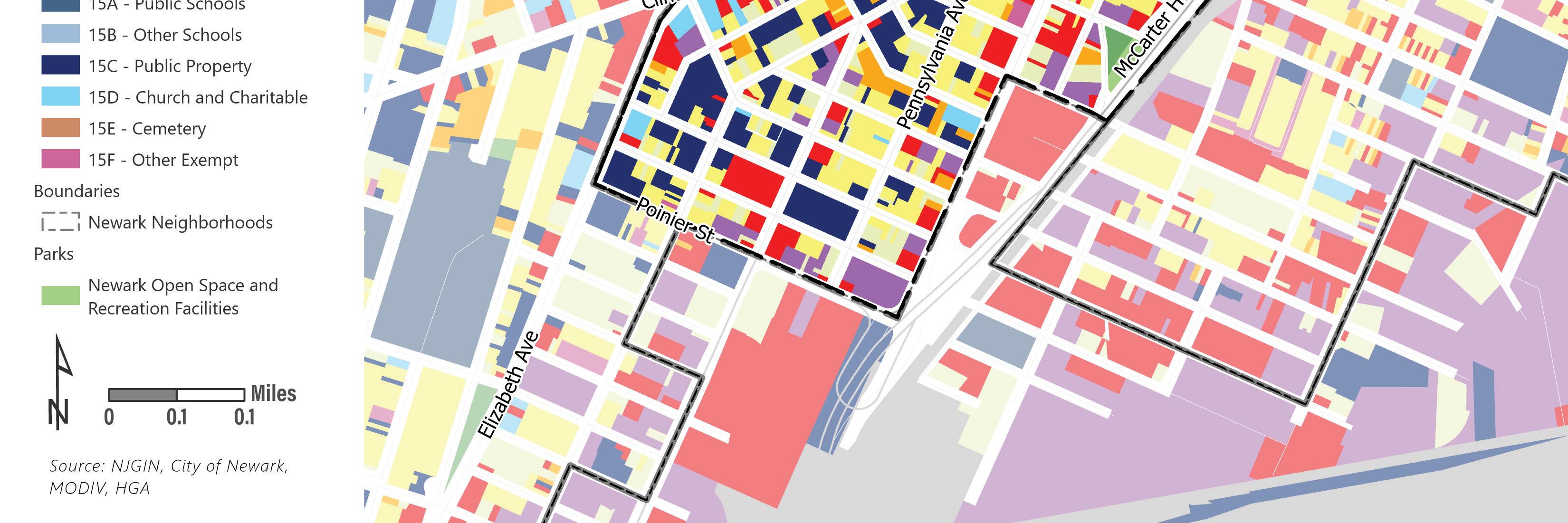
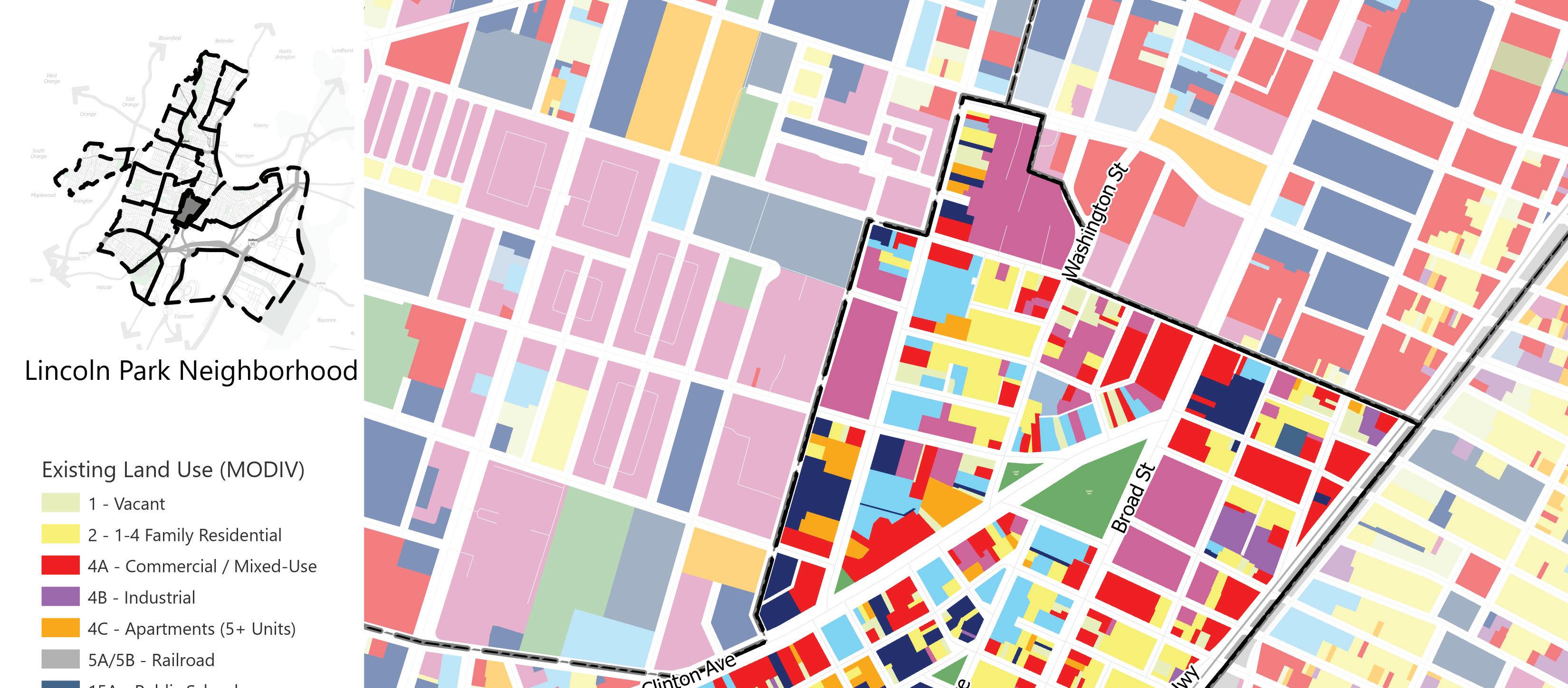
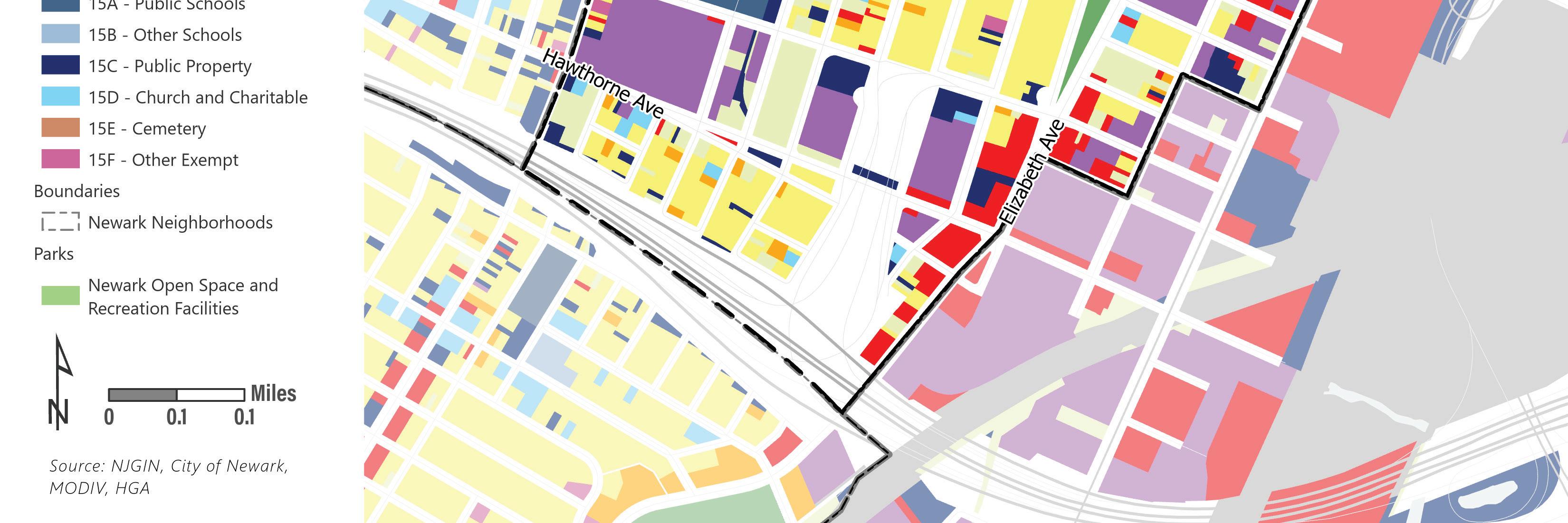
Lincoln Park
The Lincoln Park neighborhood is in Newark’s Central Ward. The neighborhood boundaries are Kinney Street and Court Street to the north, Broad Street and McCarter Highway to the east, Poinier Street to the south, and Martin Luther King Jr. Boulevard, Quitman Street, Clinton Avenue, and Elizabeth Avenue to the west. Lincoln Park is a mixed-use neighborhood. There are a range of residential building types from one- and two-family homes to high-rise residential buildings. The major thoroughfares are Clinton Avenue, McCarter Highway, and Broad Street where most of the neighborhood’s commercial properties are concentrated. There are industrial uses in the southern corner of the neighborhood. There are five parks in the neighborhood: Lincoln Park, Clinton Park, Clinton Avenue Park, Jackson Park and Tichenor Park. The neighborhood contains the Lincoln Park Historic District and the Lincoln Park Redevelopment Area.
20 | Appendix I.
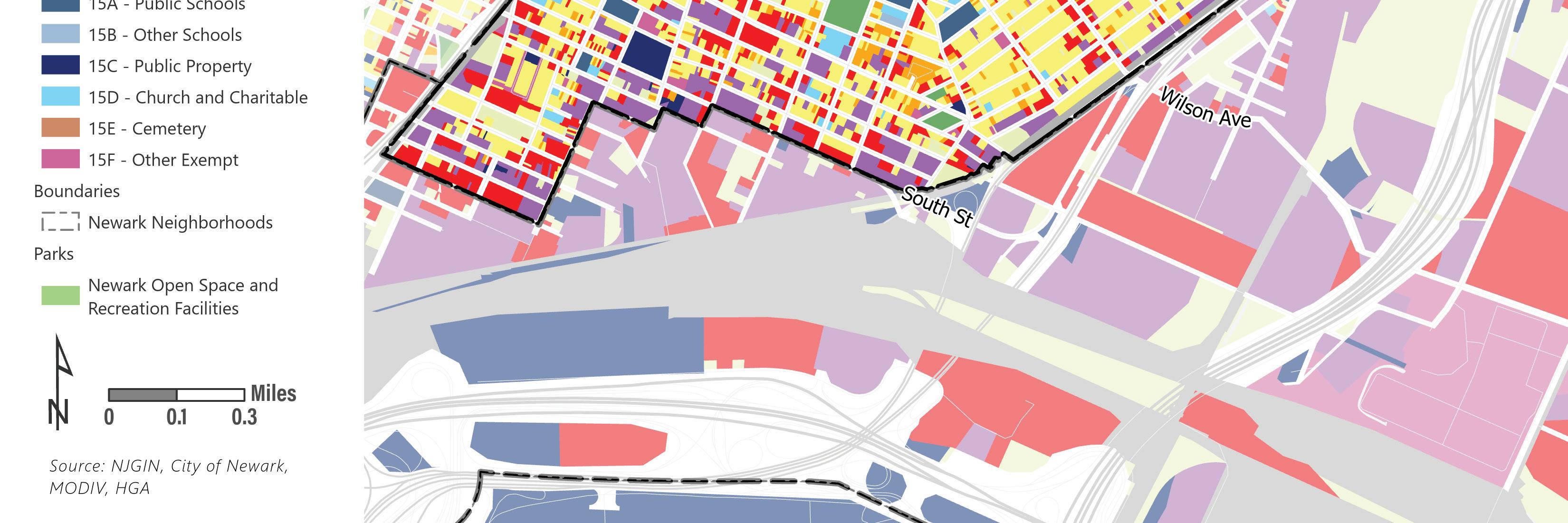
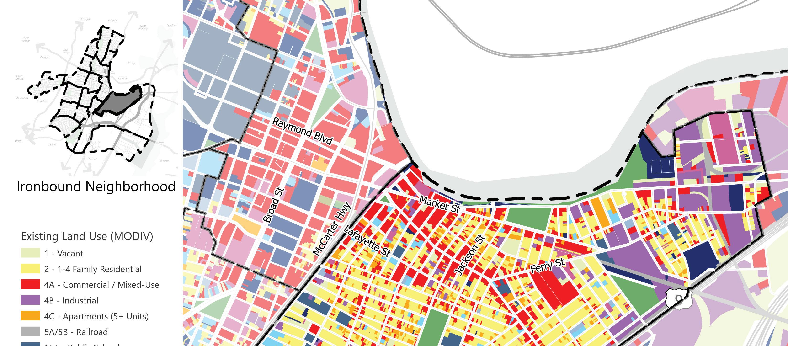
Ironbound
The Ironbound neighborhood is in Newark’s East Ward. The boundaries are Lister Avenue and the Passaic River to the north, Route 1, Route 9, and Lockwood Street to the east, Miller, Parkhurst, Thomas, and South Streets to the south, and the Amtrak/ NJ Transit Northeast Corridor right-of-way to the west. Ironbound is a mixed-use neighborhood and Newark’s densest neighborhood. The neighborhood consists mostly of two- and three-family homes and mixed-use buildings. The northern edge of the neighborhood is in the Riverfront Public Access and Redevelopment Area. Open space consists of Hayes Park, Riverbank Park, Independence Park, and the Ironbound Recreation Center.
Land Use (MODIV)
Vacant
1-4 Family Residential Commercial/Mixed-use
Industrial
Apartments (5+ units)
Railroad Public Schools
Other Schools
Public Property Church and Charitable Cemetery
Other Exempt Open Space
Land Use Element | 21
Land Use (MODIV)
Vacant
1-4 Family Residential
Commercial/Mixed-use
Industrial
Apartments (5+ units)
Railroad Public Schools
Other Schools
Public Property
Church and Charitable Cemetery
Other Exempt
Open Space
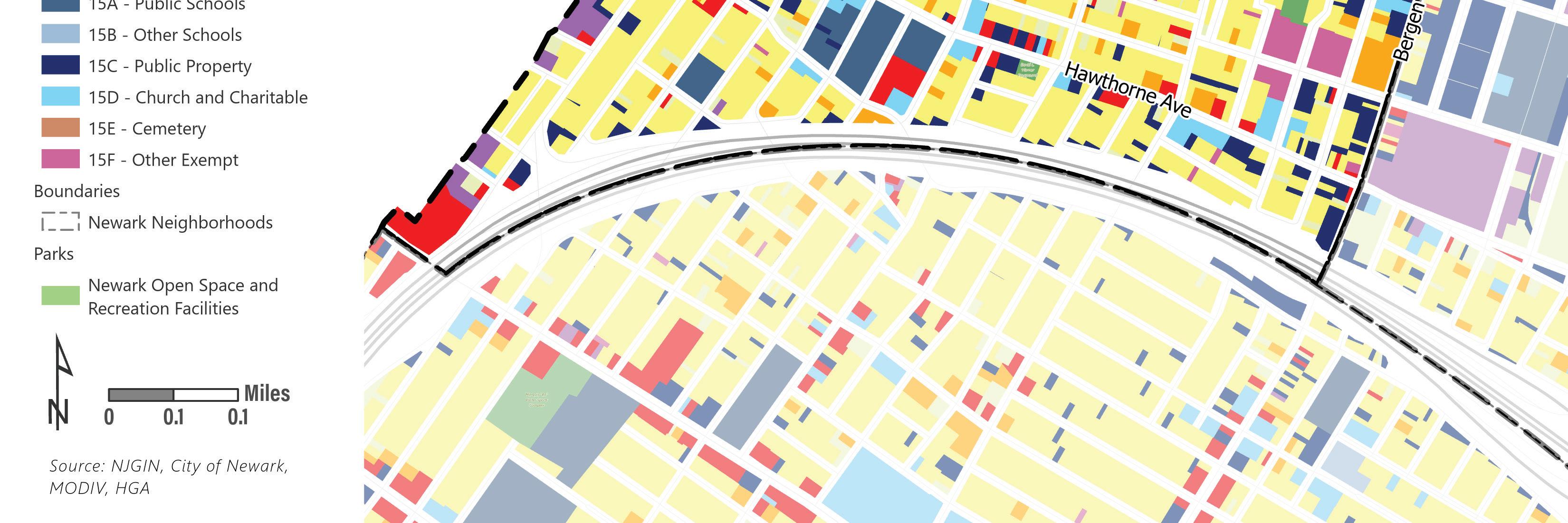
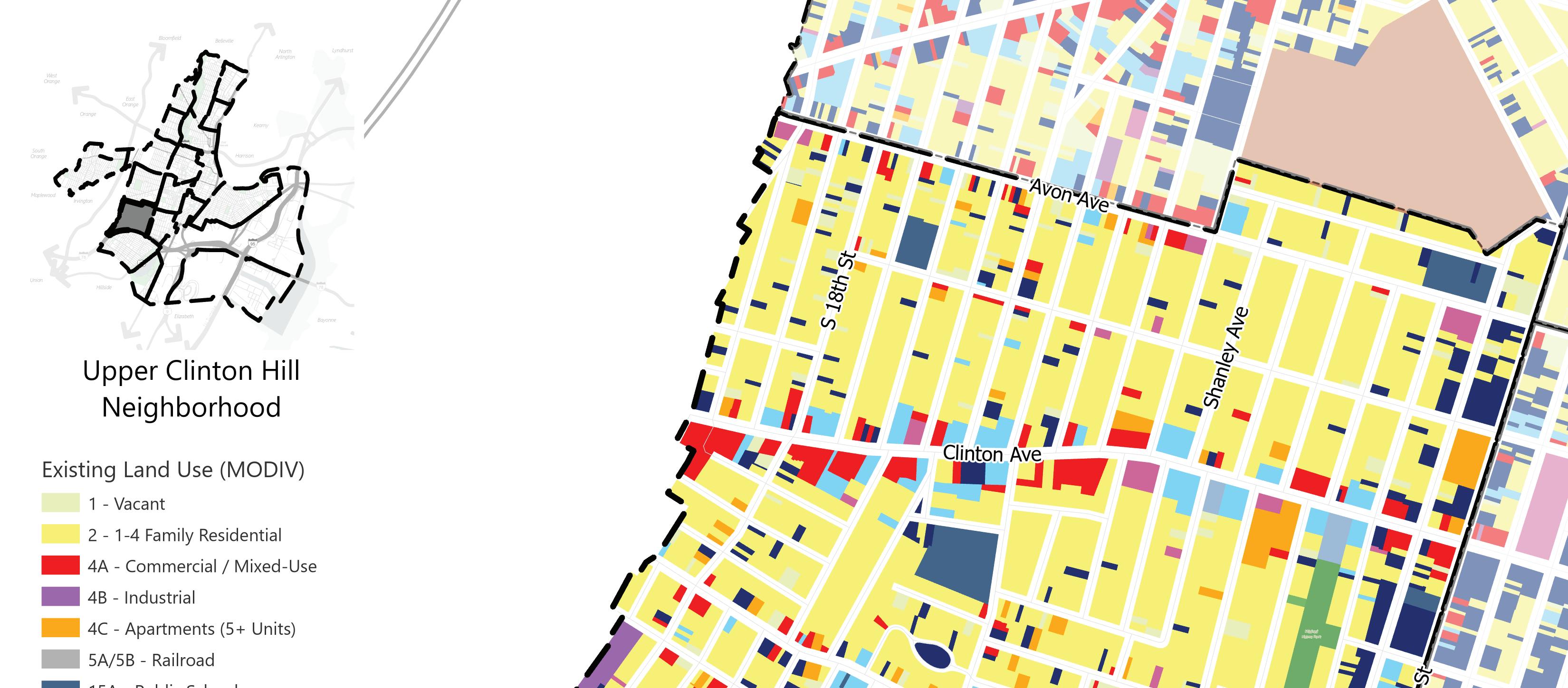
Upper Clinton Hill
The Upper Clinton Hill neighborhood is in Newark’s South Ward and is bounded by Woodland Cemetery and Avon Avenue to the north, Bergen Street to the east, Route 78 to the south, and Newark and Irvington Township municipal boundary to the west. Upper Clinton Hill is primarily residential with commercial uses concentrated along the main commercial corridors, Clinton Avenue and Hawthorne Avenue. Open space in the neighborhood consists of Mildred Helms Park, Homestead Park, and Herpers Park. The parcels north of Avon Avenue are part of the Kent/Brenner/Springfield Redevelopment Area.
22 | Appendix I.
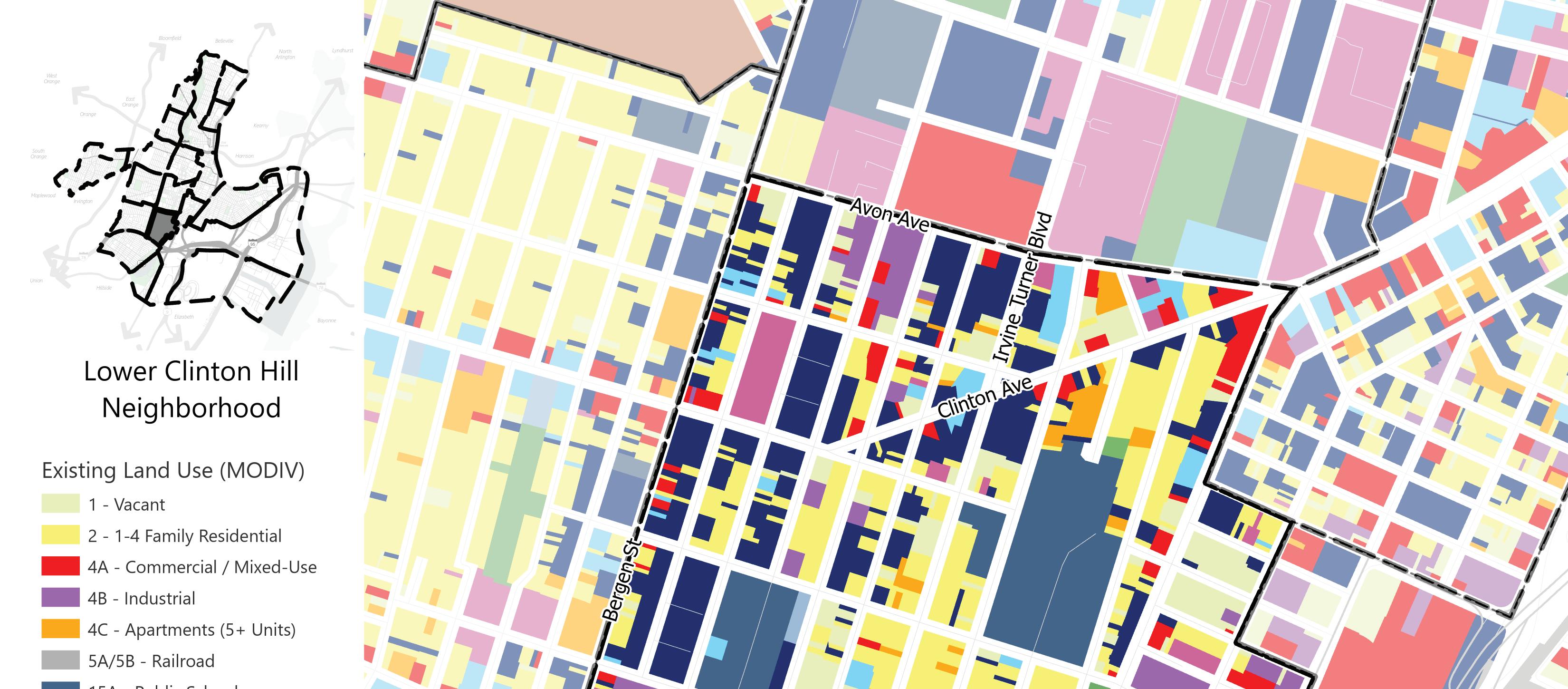
Lower Clinton Hill
The Lower Clinton Hill neighborhood is in Newark’s South Ward. The neighborhood is bounded by Avon Avenue to the north, Elizabeth Avenue, Sherman Avenue, and Frelinghuysen Avenue to the east, Interstate 78 to the south, and Bergen Street to the west. There are a mix of residential, commercial, and industrial uses. Three parks in Lower Clinton Hill provide access to open space: Schleifer Memorial Park, Peshine Park, and Hunterdon Street Park.
Land Use (MODIV)
Vacant
1-4 Family Residential Commercial/Mixed-use
Industrial
Apartments (5+ units)
Railroad Public Schools
Other Schools
Public Property
Church and Charitable Cemetery
Other Exempt
Open Space
Land Use Element | 23
Land Use (MODIV)
Vacant
1-4 Family Residential Commercial/Mixed-use
Industrial
Apartments (5+ units)
Railroad Public Schools
Other Schools
Public Property Church and Charitable
Cemetery
Other Exempt
Open Space
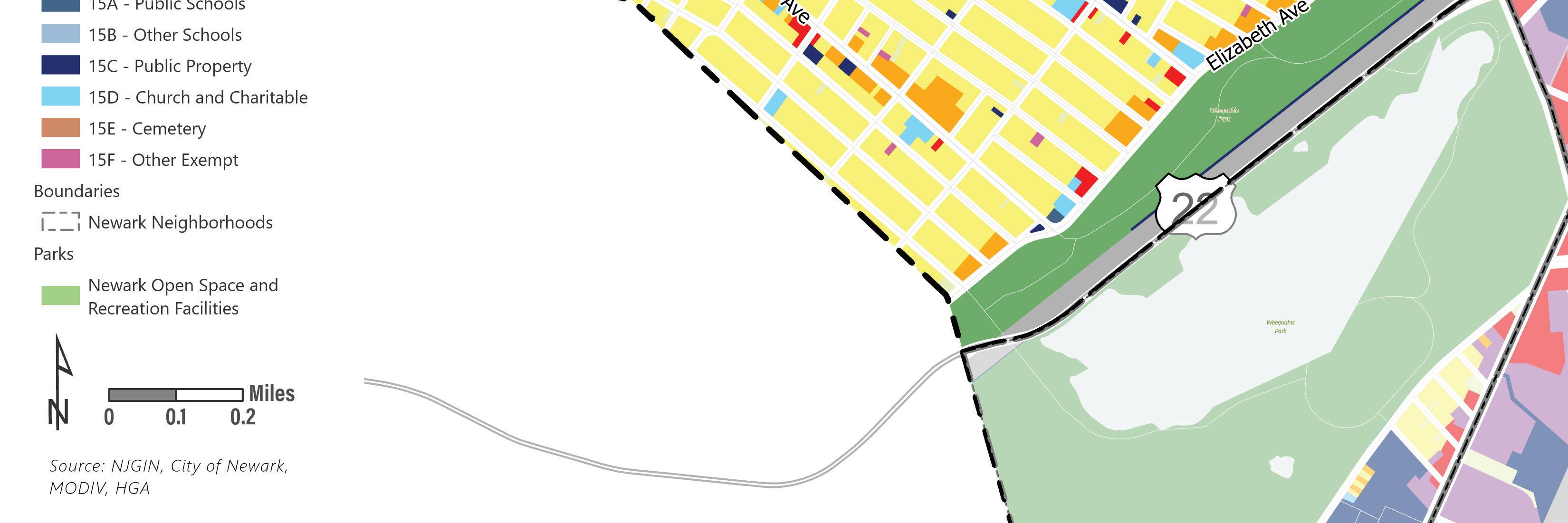
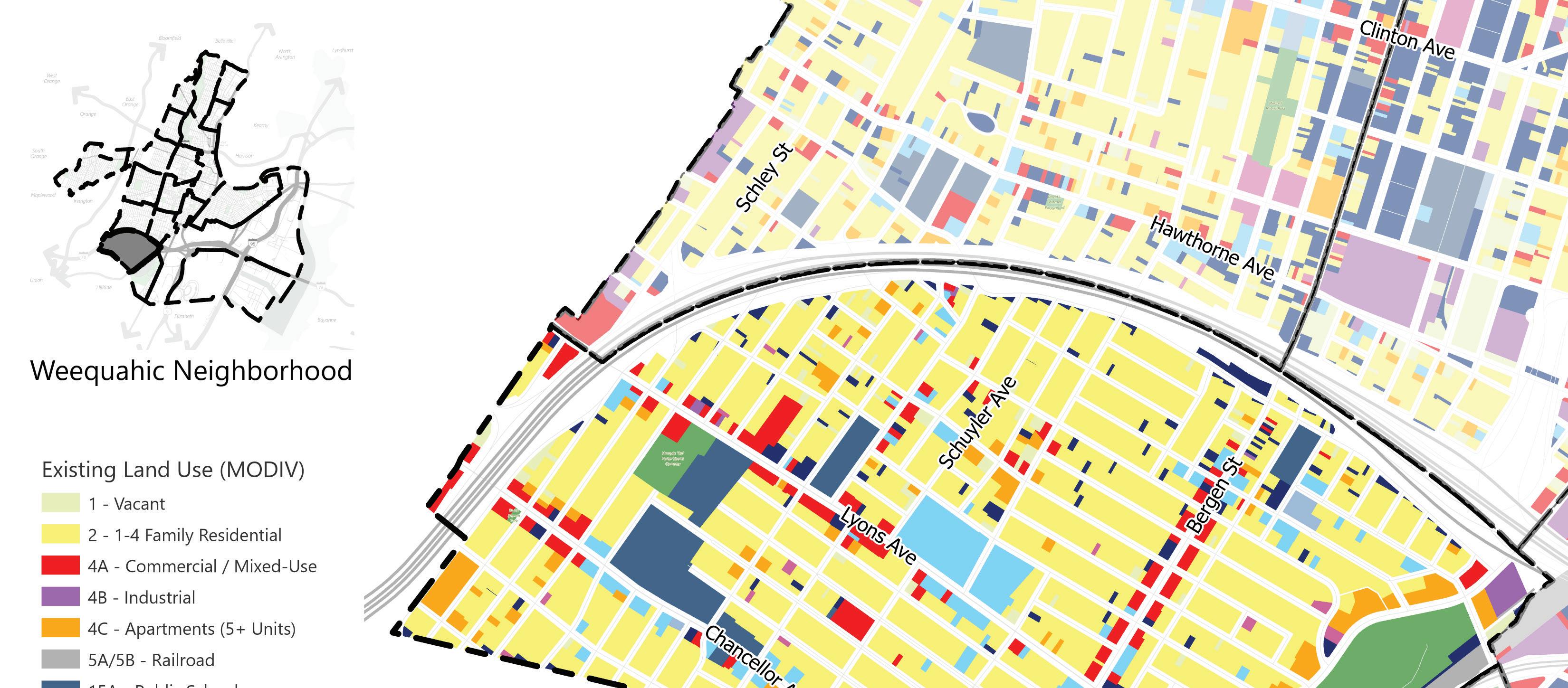
Weequahic
The Weequahic neighborhood is in Newark’s South Ward. The boundaries of the neighborhood are Route 78 to the north, Route 22 to the east, the Newark and Elizabeth municipal boundary to the south, and Fabyan Place and the Newark and Irvington Township municipal boundary to the west. Weequahic is primarily residential. Commercial uses are concentrated along Lyons Avenue and Bergen Street. Weequahic Park is in the eastern part of the neighborhood. Part of the South Bergen Redevelopment Area is in the Weequahic neighborhood, encompassing the properties along Bergen Street north of Lyons Avenue. The Weequahic Park Historic District is partially in the Weequahic neighborhood.
24 | Appendix I.
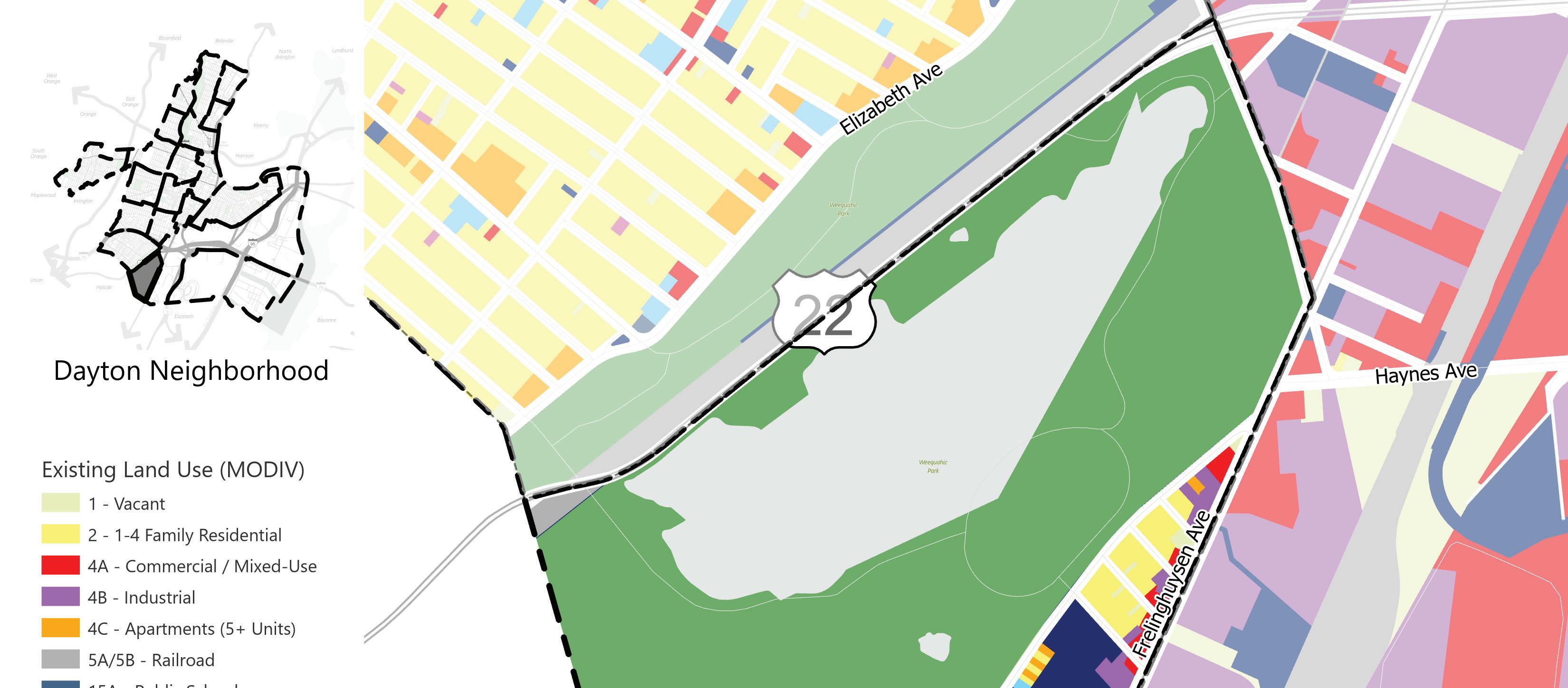
Dayton
The Dayton neighborhood is in Newark’s South Ward and is bounded by Meeker Avenue to the north, Frelinghuysen Avenue to the east, the Newark and Elizabeth municipal boundary to the south, and Route 22 to the west. Dayton is a mixeduse neighborhood, with residential, commercial, and industrial uses. Dayton’s commercial and industrial uses are found along Frelinghuysen Avenue. Many of the neighborhood’s properties are vacant, and efforts are being made to revitalize them. The abandoned Seth Boyden Court public housing complex occupying 15 acres of the neighborhood is intended to be replaced by a film production facility and new housing. Weequahic Park occupies the western portion of the neighborhood.
Land Use (MODIV)
Vacant
1-4 Family Residential Commercial/Mixed-use
Industrial
Apartments (5+ units)
Railroad Public Schools
Other Schools
Public Property Church and Charitable Cemetery
Other Exempt
Open Space
Land Use Element | 25
Land Use (MODIV)
Vacant
1-4 Family Residential Commercial/Mixed-use Industrial Apartments (5+ units)
Railroad Public Schools
Other Schools
Public Property
Church and Charitable Cemetery
Other Exempt
Open Space
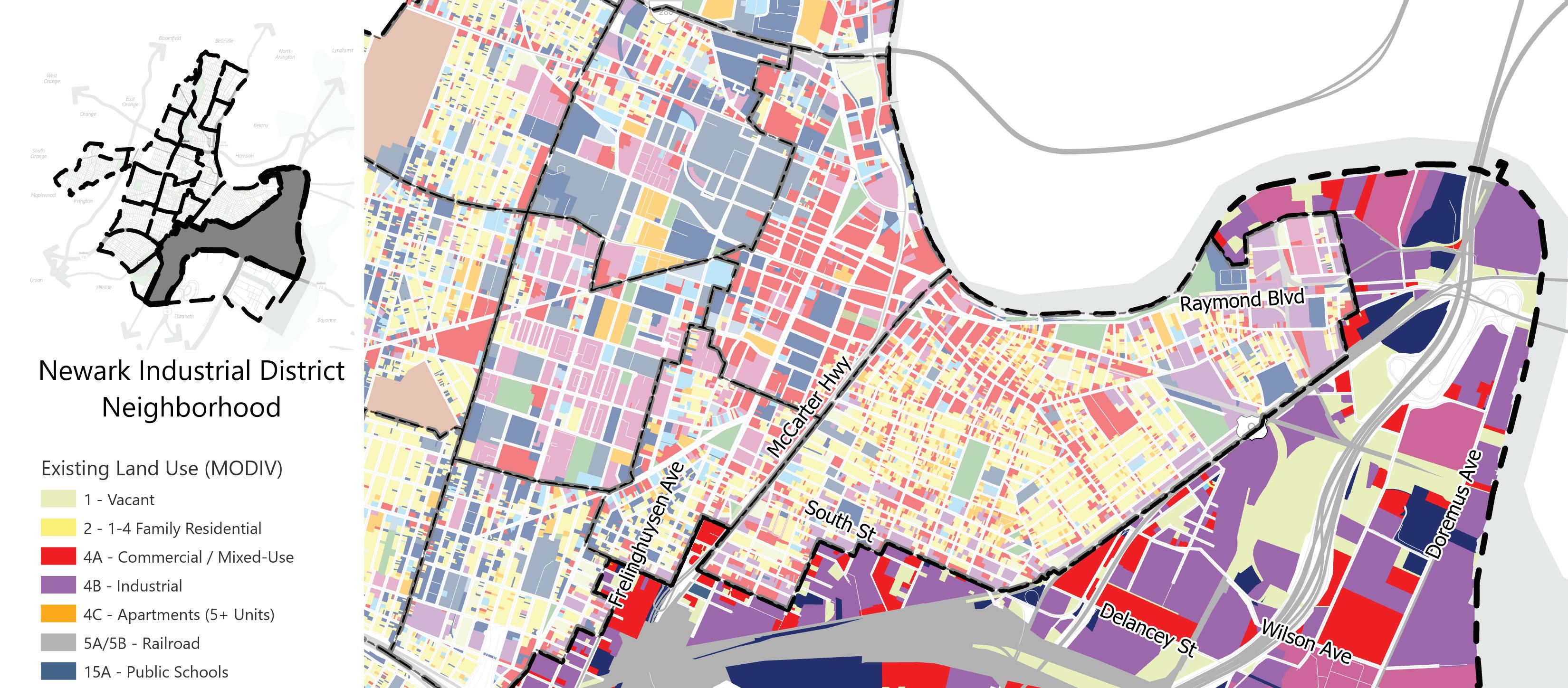
Newark Industrial District
The Newark Industrial District is in Newark’s East and South Wards. The Newark Industrial District boundaries are the Passaic River to the north and east, Interstate 78, Route 1, Route 9 and the Newark and Elizabeth municipal boundary to the south, and Frelinghuysen Avenue, Meeker Avenue, Elizabeth Avenue, Sherman Avenue, Broad Street, Avenue C, Route 1, Rout 9 and Lockwood Street to the west. The district is almost entirely industrial. A handful of commercial properties are found along Route 1 and Route 9 in the western portion of the district near Newark International Airport. There is no open space in the district.
26 | Appendix I.
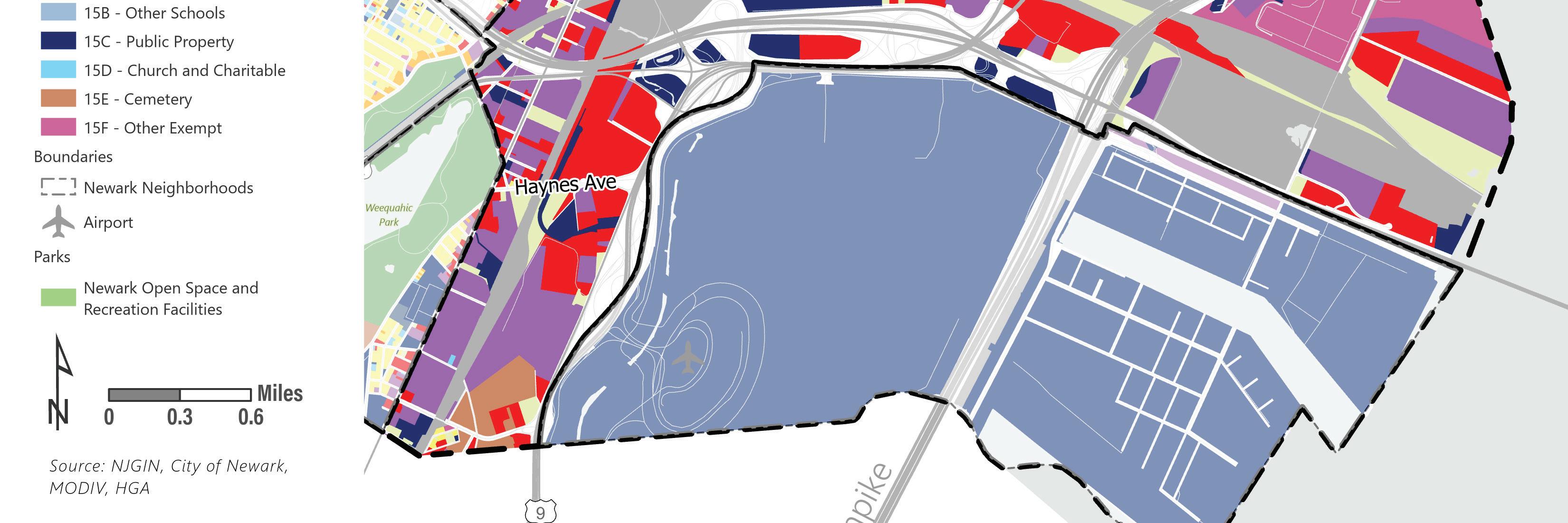
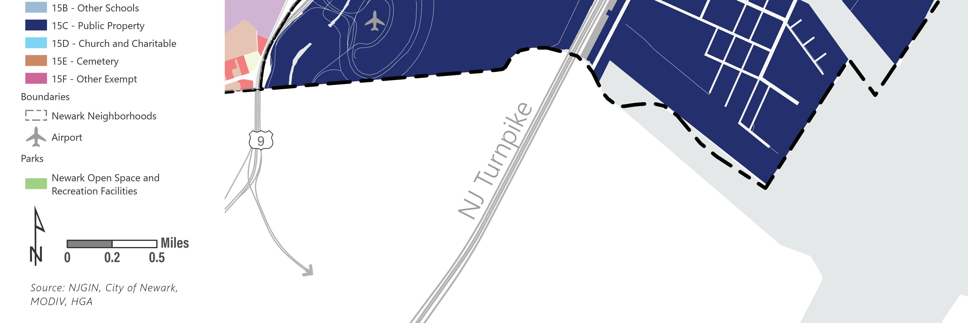
Port District
The Port District is in Newark’s East and South Wards. The boundaries of the district are Interstate 78 to the north, the Passaic River to the east, the Newark and Elizabeth municipal boundary to the south, and Route 1 and Route 9 to the west. The Port District includes Newark Liberty International Airport and the Port of Newark characterized by industrial uses.
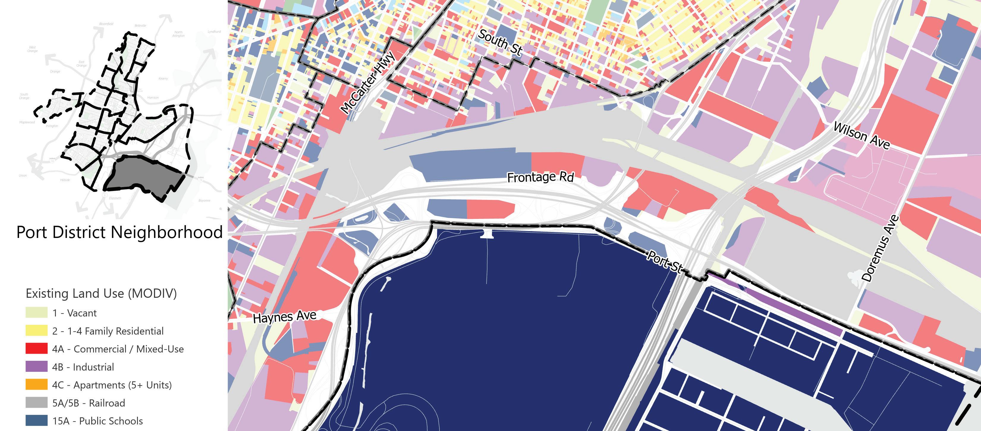
Land Use (MODIV)
Vacant
1-4 Family Residential Commercial/Mixed-use Industrial Apartments (5+ units)
Railroad Public Schools
Other Schools
Public Property
Church and Charitable Cemetery
Other Exempt
Open Space
Land Use Element | 27
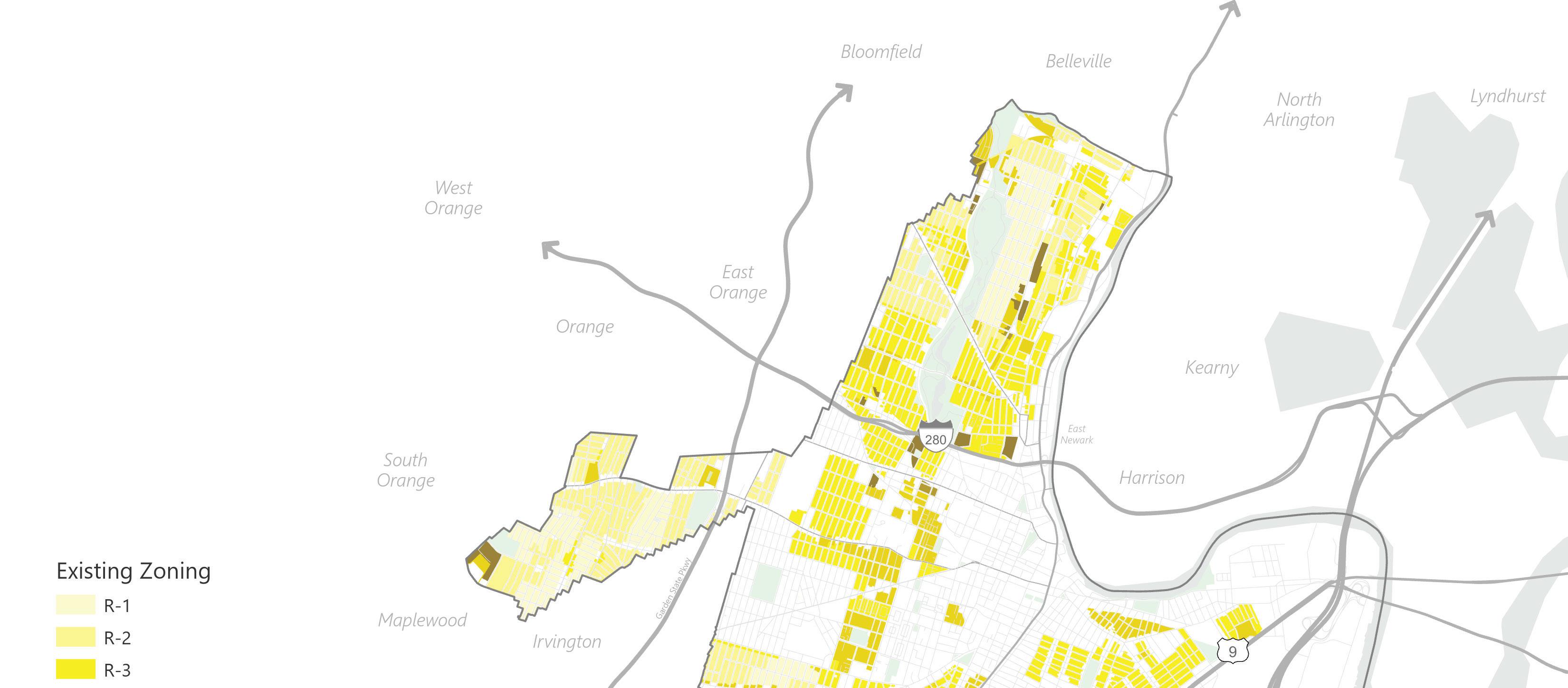
Existing Zoning
After the city’s 2012 Master Plan was adopted, a comprehensive update to the city’s Zoning and Land Use Regulations was prepared. The new Ordinance was adopted in February 2015, consolidating former Titles 37 (Land Use Procedures), 38 (Subdivision and Site Plan Procedures), and 40 (Zoning Ordinance) into Title 41 Newark Zoning and Land Use Regulations (“NZLUR”). The NZLUR created a hybrid approach to land use regulation combining formbased standards for different building types with traditional zone and use requirements.
Existing Zoning
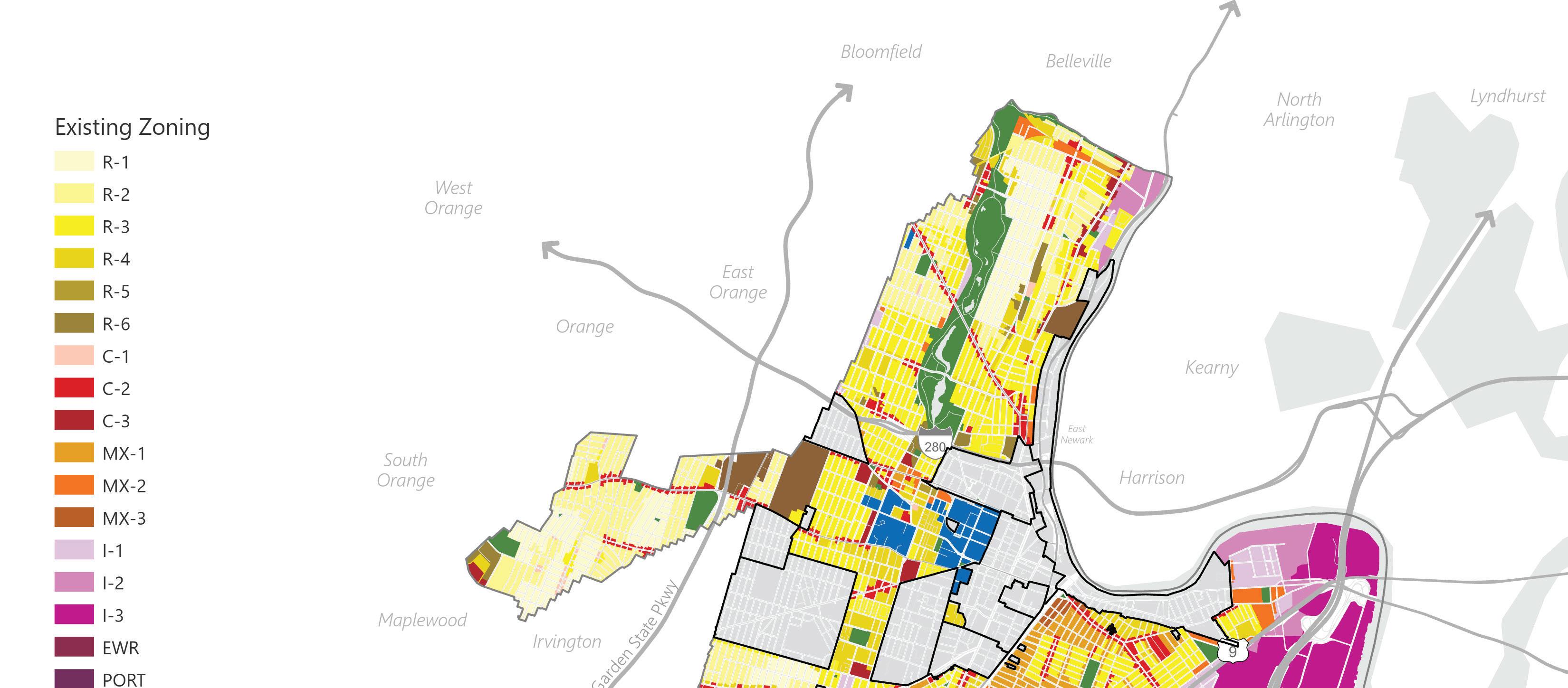 Figure 4 Existing Zoning, prepared by HGA
R-1 R-2 R-3 R-4 R-5 R-6 C-1 C-2 C-3 MX-1 MX-2 MX-3 I-1 I-2 I-3 EWR PORT INST CEM PARK RDV
28 | Appendix I.
Residential
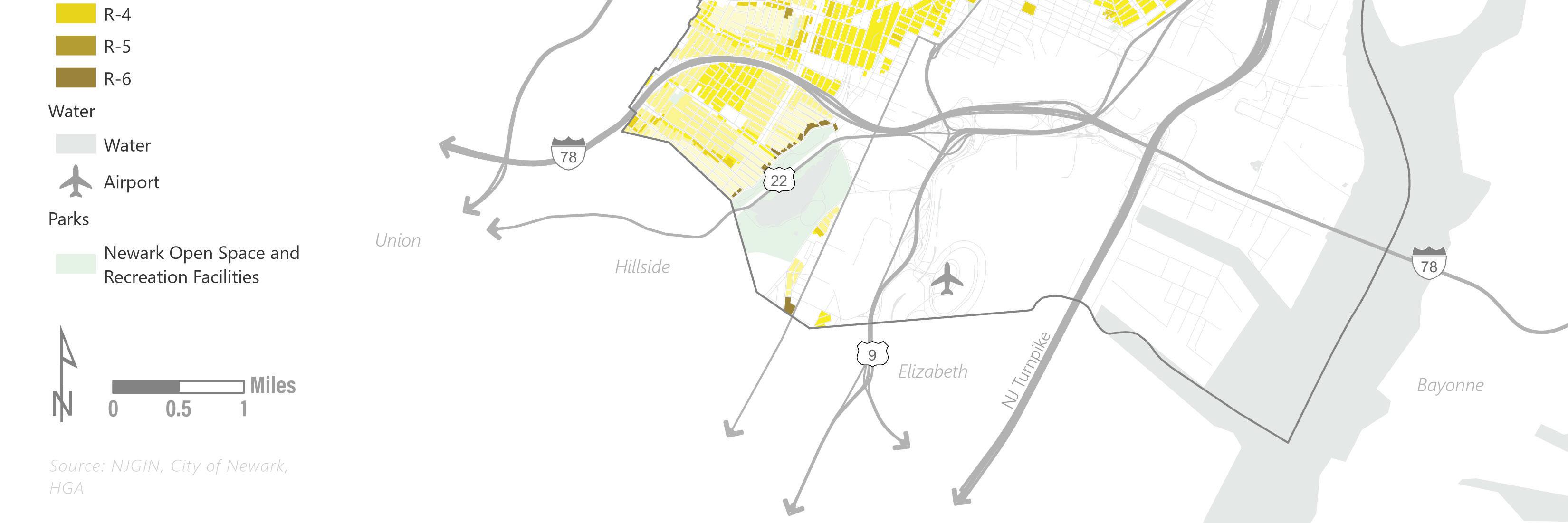
There are six residential districts in Newark: Residential One-Family (R-1), Residential One-to-Two Family (R-2), Residential One-to-Three Family and Town House (R-3), Residential Low-Rise Multifamily (R-4, Residential Mid-Rise Multifamily (R-5), and Residential High-Rise Multifamily (R-6).
Existing Zoning
R-1
Figure 5 Residential Zoning, prepared by HGA
R-2 R-3 R-4 R-5 R-6
Land Use Element | 29
Residential Zoning Districts
● The R-1 Zone permits only single-family residential homes up to three stories. Other permitted uses are municipal uses and active and passive recreation. Schools are permitted as conditional uses. The R-1 Zone is generally located within the city’s residential historic districts and other traditionally lower density neighborhoods, including Forest Hill, Weequahic, Clinton Hill, and Vailsburg.
● The R-2 Zone permits single- and two-family homes up to three stories. Other permitted uses include municipal uses, active and passive recreation, and community gardens. Childcare centers, places of worship, and schools are permitted as conditional uses.
● The R-3 Zone allows for one-, two-, and threefamily homes and townhouses up to three stories. Other permitted uses include urban farms, municipal uses, active and passive recreation, and community gardens. Community centers, childcare centers, places of worship, and schools are permitted as conditional uses in the R-3 Zone.
● The R-4 Zone allows one-, two-, and three-family homes and townhouses up to three stories and low-rise multifamily dwellings. Other permitted uses include ground-floor commercial, urban farms, municipal uses, active and passive recreations, and community gardens. Assisted living facilities and nursing homes, community centers, childcare centers, places of worship, and schools are permitted as conditional uses in the R-4 Zone.
● The R-5 Zone permits low-rise multi-family dwellings and mid-rise multifamily dwellings. Other permitted uses include ground-floor commercial, urban farms, municipal uses, active and passive recreation, and community gardens. Assisted living facilities and nursing homes, community centers, childcare centers, places of worship, and schools are permitted as conditional uses in the R-5 Zone.
● The R-6 Zone permits the highest residential density allowing only low-rise, mid-rise, and high-rise multi-family dwellings. The other permitted uses and conditional uses are the same as the R-5 Zone. All six residential districts permit community residences, shelters for victims of domestic violence, and adult family care homes.
30 | Appendix I.
Development of residential units in residential and mixed-use zones is controlled by building types in the Newark Zoning and Land Use Regulations. Each building type has a minimum lot area requirement, bulk / setback standards, including maximum height, and a maximum permissible density based on a square footage of lot area per dwelling unit requirement. The following residential building types are permitted in various zones throughout the city:
Building Type
Lot Area Per Dwelling Unit Required DU/Acre
Minimum Lot Area
Maximum Height (Stories)
One-Family 5,000 8.7 5,000 3
Two-Family 1,250 34.8 2,500 3
Three-Family 1,165 37.4 3,500 3
Townhouse 770 56.6 7,000 3
Low-Rise 625 69.7 10,000 4
Mid-Rise 350 124.5 10,000 8
High-Rise 300 145.2 10,000 10+
Mixed-Use 130-300 75-335 3,500 5 (145’ in MX-3)
Land Use Element | 31
Commercial Districts
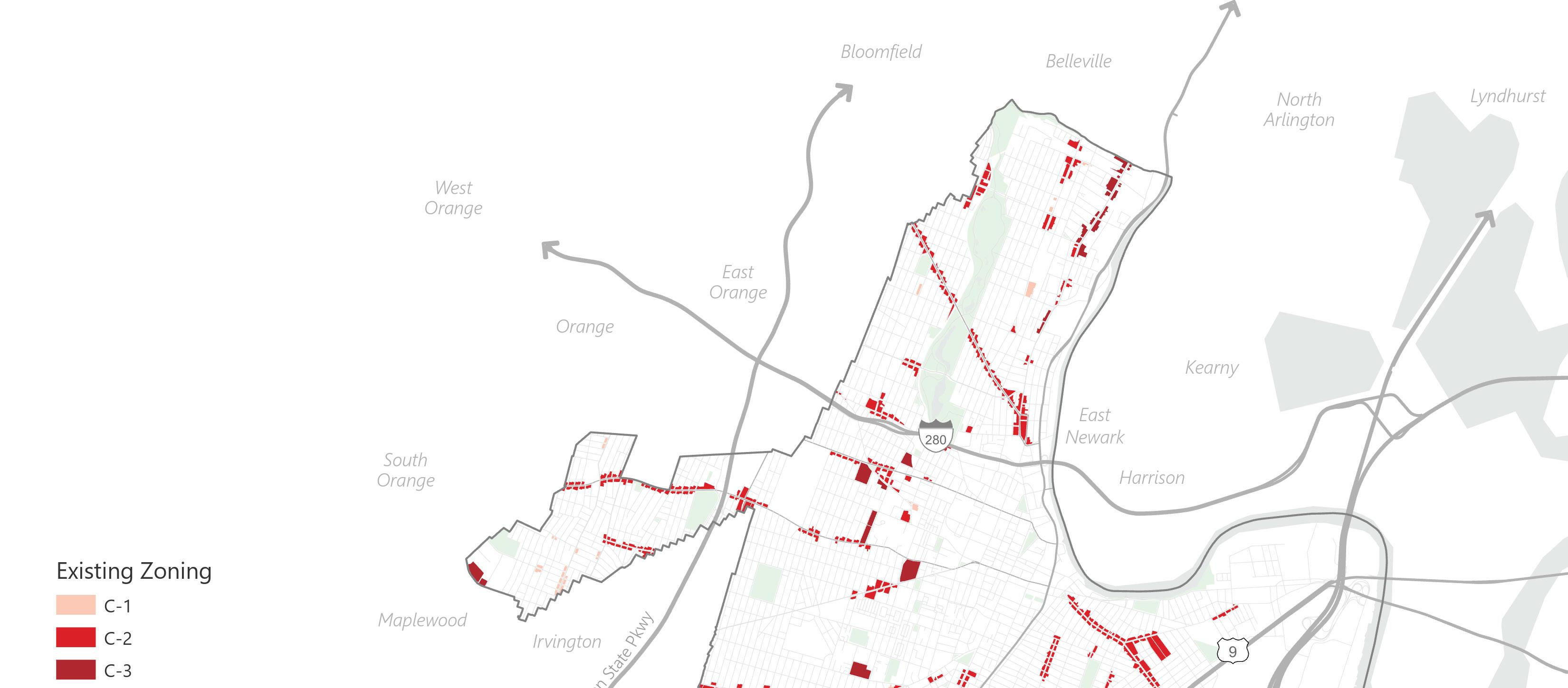
There are three commercial districts in Newark: Neighborhood Commercial (C1), Community Commercial (C-2), and Regional Commercial (C-3). The scale of development and variety of uses increases from the C-1 Zone to the C-3 Zone. The C-1 Zone permits small-scale commercial development that preserves neighborhood character and serves the neighborhood in which it is found. Ground-floor commercial uses with commercial or residential above are allowed in buildings up to four stories. The C-2 Zone allows moderate-scale commercial development and more permitted uses than the C-1 Zone. Ground-floor commercial uses with commercial or residential above are allowed in buildings up to five stories. The C-3 Zone permits larger-scale commercial development meant to serve more than its immediate neighborhood. Ground-floor commercial uses with commercial or residential above and detached commercial buildings are allowed in buildings up to eight stories. The C-3 Zone permits more uses than the C-2 Zone.
 Figure 6 Commercial Zoning, prepared by HGA
Zoning
Figure 6 Commercial Zoning, prepared by HGA
Zoning
C-1 C-2 C-3 Existing
32 | Appendix I.
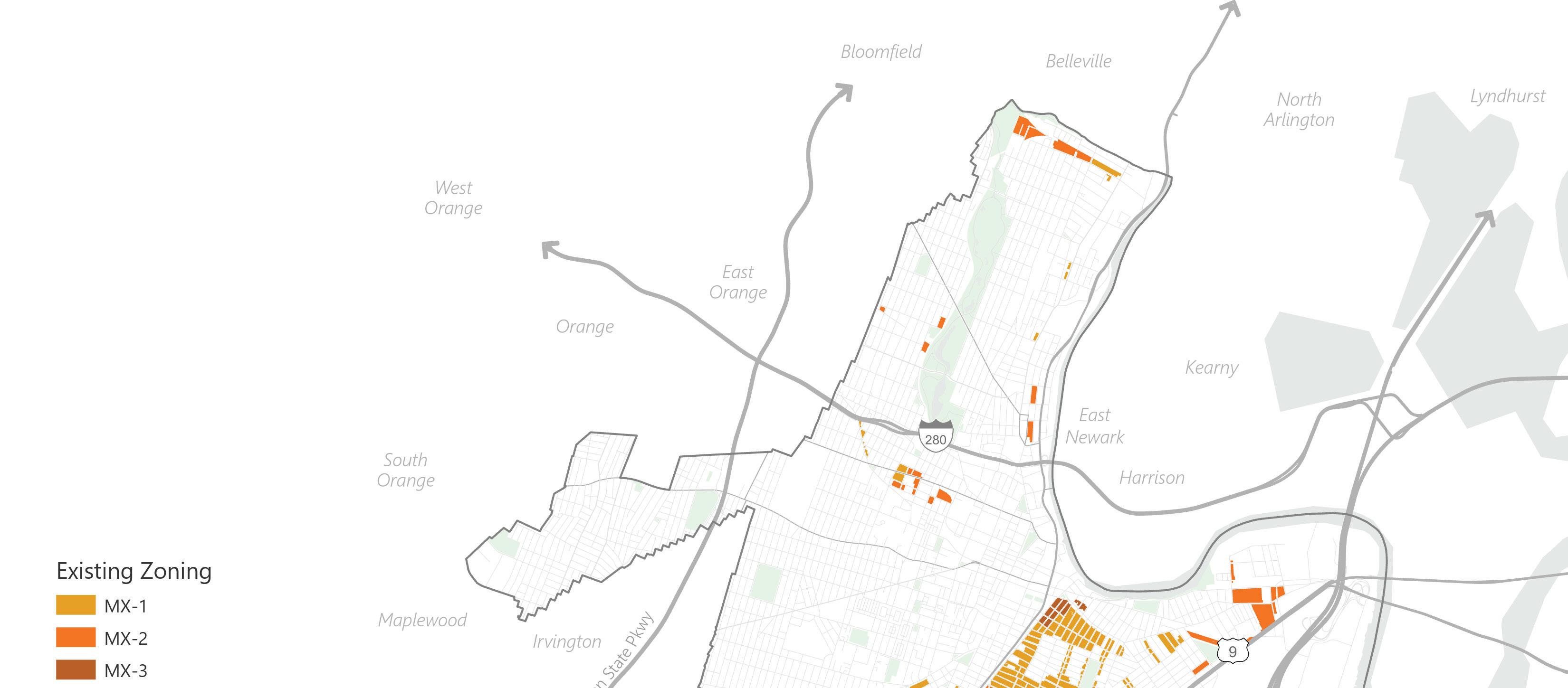
Mixed-Use Districts
There are three mixed-use districts in Newark: Mixed-Use 1 Residential and Commercial (MX-1), Mixed-Use 2 Residential, Commercial, Industrial (MX-2), and Mixed-Use 3 Residential & Commercial (MX-3). The MX-1 Zone allows for a mix of residential and commercial uses within a building or neighborhood. One-, two-, and three-family homes and townhomes up to three stories and low-rise, multi-family housing up to four stories are permitted uses. Ground-floor commercial uses with commercial or residential above are permitted. The MX-2 Zone allows for a mix of residential, commercial, and industrial uses. The MX-2 Zone permits the same residential and commercial uses as the MX-1 Zone. Many industrial uses permitted in the I-1 Zone are permitted in the MX-2 Zone.
The MX-3 Zone consists of parcels in the East Ward generally within one-half mile of Newark Penn Station. It permits a mix of residential and commercial uses with the predominant model being dense mixed-use developments that can capitalize on and support nearby commercial corridors, transit, and the Downtown Core area.
MX-1
MX-2
MX-3
Figure 7 Mixed-Use Zoning, prepared by HGA
Zoning
Existing
Land Use Element | 33
Existing Zoning
I-1 I-2 I-3
Industrial Districts
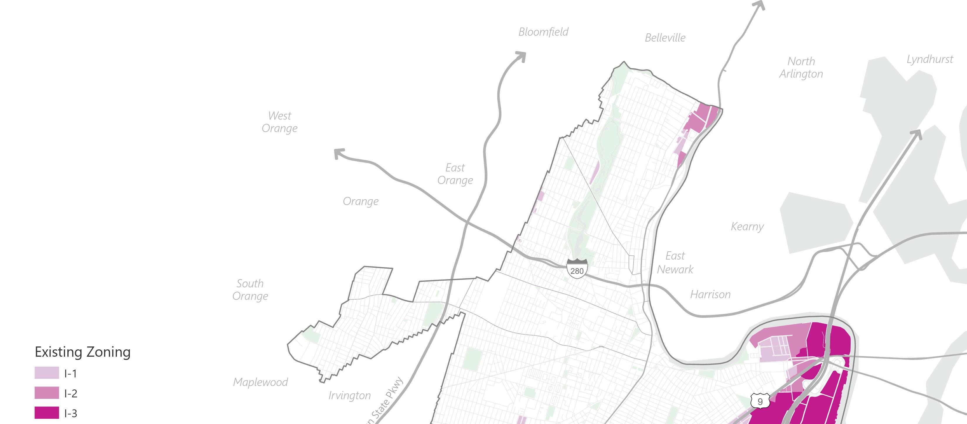
There are three industrial districts in Newark: Light Industrial (I-1), Medium Industrial (I-2), and Heavy Industrial (I-3) Zone. The permitted uses become less compatible with residential neighborhoods from the I-1 Zone to the I-3 Zone. The I-1 Zone permits light manufacturing and other non-nuisance uses such as sit-down and take-out restaurants, nightclubs, and self-storage. The I-2 Zone permits industrial development, including light and medium manufacturing. The I-3 Zone permits industrial development not compatible with residential neighborhoods, including heavy manufacturing, power generation facilities, and waste transfer stations. The maximum height for all industrial uses in the industrial districts is 8 stories and 96 feet.
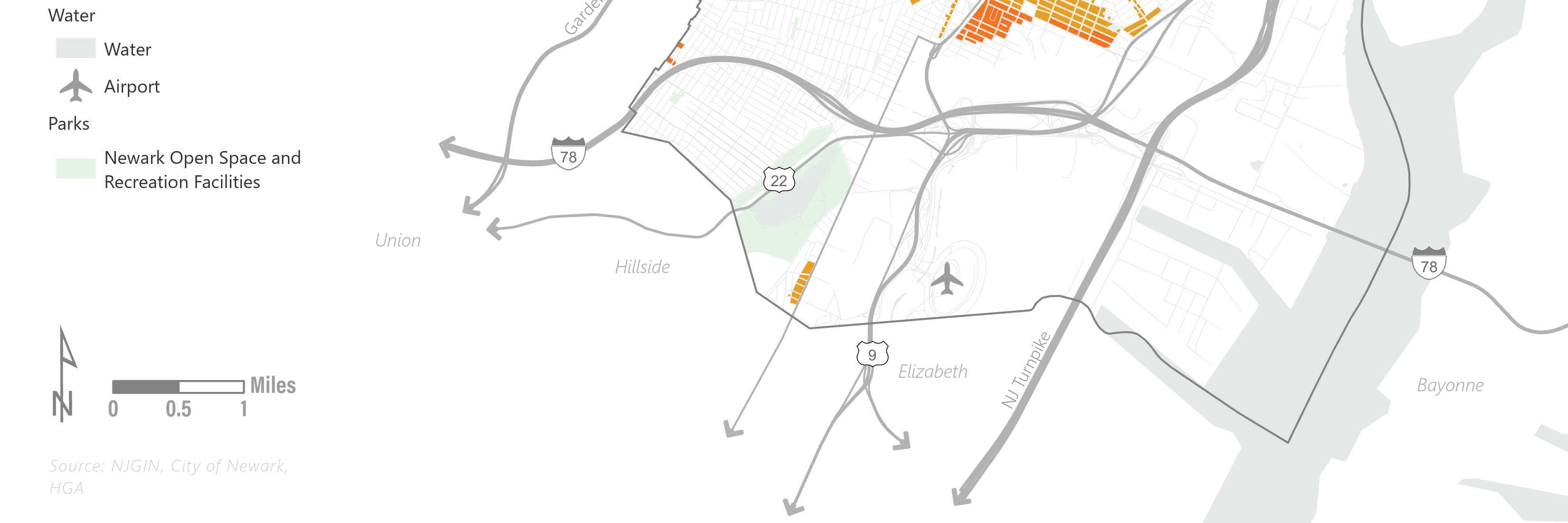
Newark’s Port (PORT) Zone applies to the Port Newark-Elizabeth Marine Terminal. The PORT Zone permits activities related to the port and its services, including manufacturing and warehousing, wholesaling, and distribution.
The Airport (EWR) and Airport Support (EWR-S) Zones apply to Newark Liberty International Airport and its surrounding area. EWR and EWR-S permit industrial uses related to the airport and its services.
Figure 8 Industrial Zoning, prepared by HGA
34 | Appendix I.
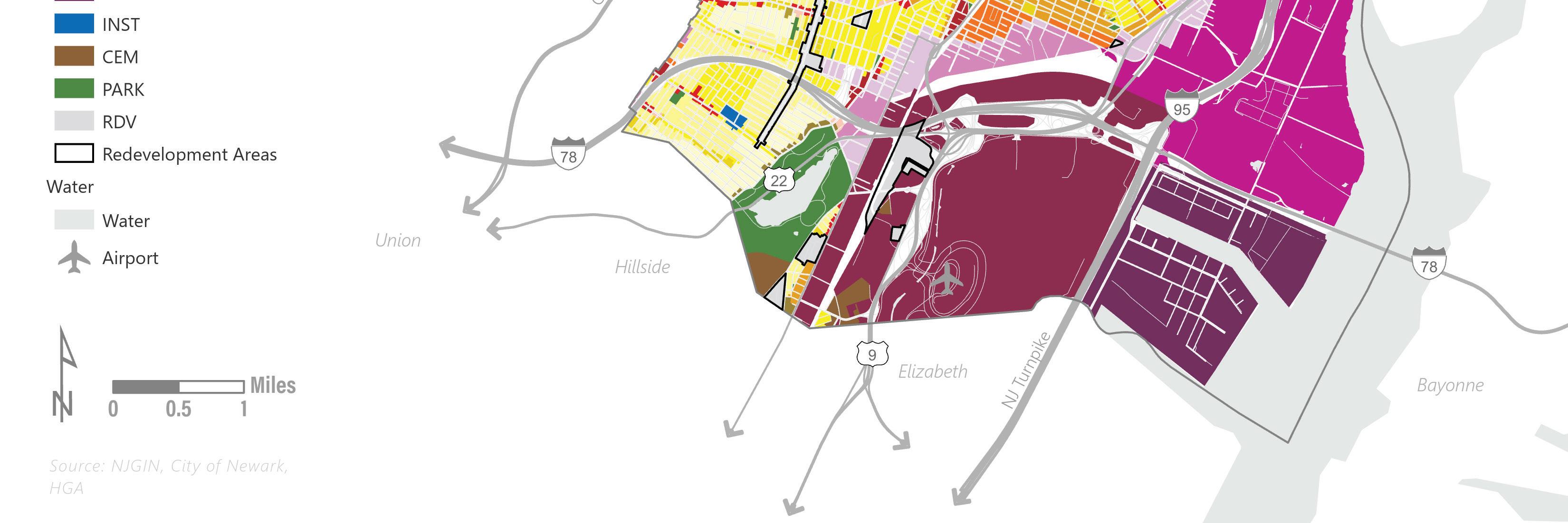
Redevelopment Plans
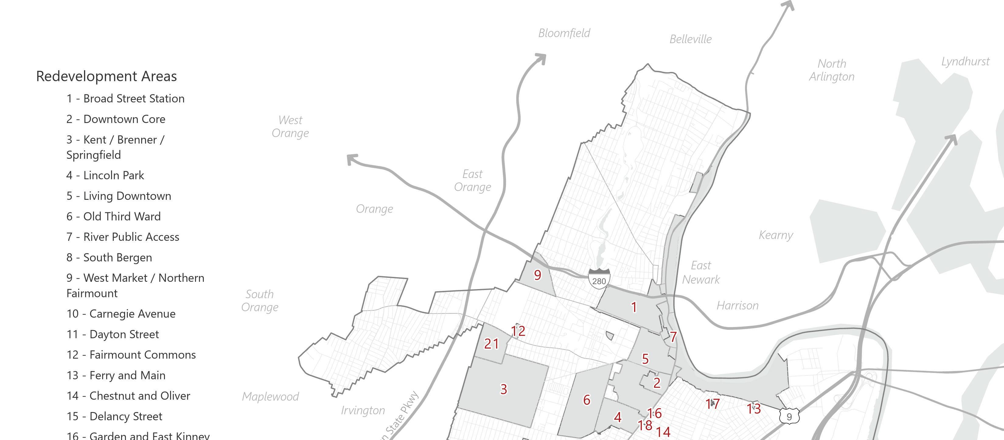
The city’s twenty-one Redevelopment Plans cover nearly the entire Downtown neighborhood, Newark Penn Station, Broad Street Station, a significant part of the Passaic riverfront, and other important parts of the city. The tools provided by the Local Redevelopment and Housing Law provide invaluable support to redevelopment projects and render developments viable that may not be otherwise. Redevelopment Plans can also provide the city with the ability to direct development of specific parcels with a greater degree of certainty and have a stronger seat at the table when reviewing the scope and terms of redevelopment projects.
1. Broad Street Station
2. Downtown Core
3. Kent / Brenner / Springfield
4. Lincoln Park
5. Living Downtown
6. Old Third Ward
7. River Public Access
8. South Bergen
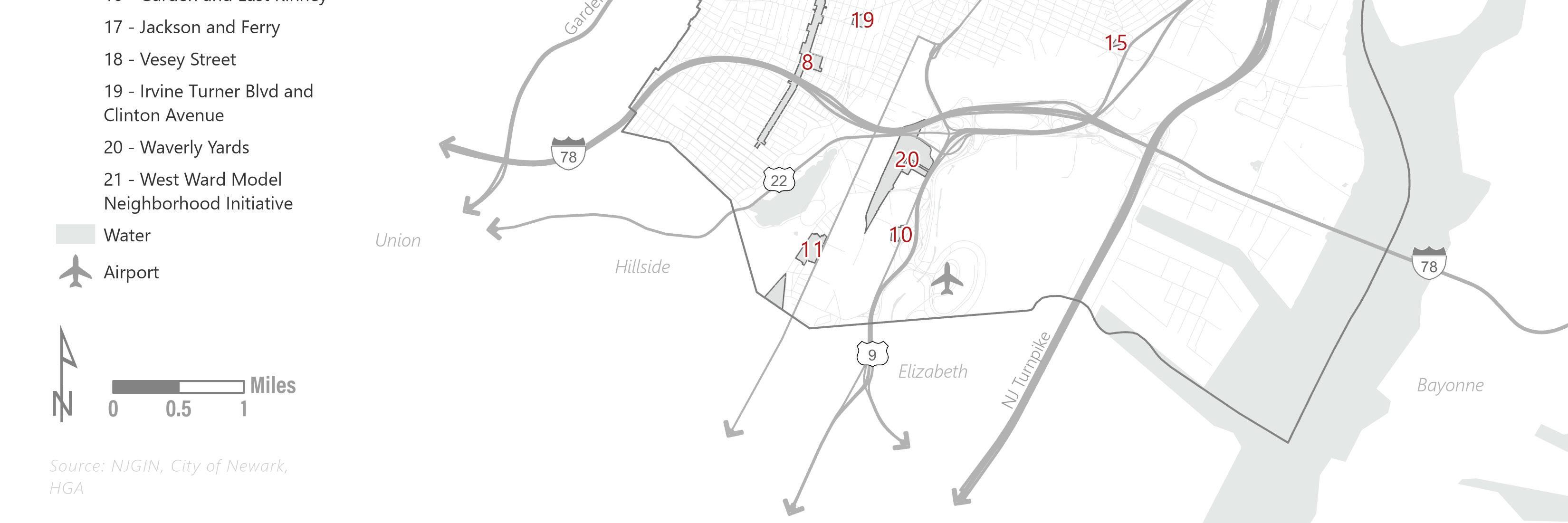
9. West Market / Northern Fairmount
10. Carnegie Avenue
11. Dayton Street
12. Fairmount Commons
13. Ferry and Main
14. Chestnut and Oliver
15. Delancy Street
16. Garden and East Kinney
17. Jackson and Ferry
18. Vesey Street
19. Irvine Turner Blvd and Clinton Avenue
20. Waverly Yards
21. West Ward Model Neighborhood Initiative
Figure 9 Redevelopment Plans, prepared by HGA Land Use Element | 35
Prior to 2015, there were 104 distinct redevelopment areas in the city, some of which dated back to urban renewal plans with roots in the 1950s. As part of the city’s effort to modernize its zoning code, the land use regulations associated with most of the plans were replaced with the newly defined zoning districts. Nine redevelopment plans were identified to remain in full effect:
Broad Street Station
● The Broad Street Station District Redevelopment Plan was adopted on January 21, 2009 and amended October 30, 2018. The Area encompasses the northern end of Downtown Newark bounded by Central Avenue to the south, Norfolk Street to the west, McCarter Highway and Broad Street to the east, and Interstate 280 and Clay Street to the north. The Area includes seven sub-districts, each with their own regulations. The focus of the Plan is to create a walkable, sustainable, and transit-oriented development hub by constructing mixeduse, mixed-income housing, encouraging new retail uses, providing adequate parking, redesigning streetscapes, and promoting open space.
● There are awkward overlaps between the Broad Street Station Plan and the Living Downtown Plan – some boundaries of the Broad Street Station Plan are defined by a distance offset from a street, which has created split lot conditions that are undesirable.
● Several major developments have been approved and constructed in the Broad Street Station Area. New mixed-use developments on Norfolk Street, Sussex Avenue, Central Avenue, Broad Street, and Orange Street have been constructed or are under construction. Additional major projects, including the Bears Stadium redevelopment, Newark Art Museum mixed-use development, and several others have been approved.
Downtown Core
● The Downtown Core District Redevelopment Plan was adopted October 6, 2004 and included an Amendment to the Newark Plaza Urban Renewal Plan. The Plan was last amended in 2017. The Area includes the parcels surrounding the Prudential Center in Downtown Newark between Broad Street and McCarter Highway. The Plan encourages high-density, mixed-use development anchored by the Prudential Center, nearby government buildings, and access to mass transit. Site specific development standards are set forth for significant development parcels.
● Since its original adoption, the most significant development in the Downtown Core Area is the construction of the Prudential Center. A more recent public improvement was the construction of the City’s Mulberry Commons Park, a triangular park extending from the Prudential Center to McCarter Highway with anticipated future connections to the Ironbound Neighborhood.
● Private developments include the Ironside Newark adaptive reuse of a former warehouse building at Edison Place and McCarter Highway into commercial and office space. To the north of Ironside a high-rise residential tower at 777 McCarter Highway is nearing completion.
● There are numerous remaining development parcels in the Downtown Core Area that are largely occupied by surface parking lots today.
36 | Appendix I.
Kent Brenner Springfield
● The Kent/Brenner/Springfield Redevelopment Plan was adopted on April 1, 2009. The Plan encompasses a 450-acre area of Newark’s West Side neighborhood. The Area is bounded by 15th Avenue, Bergen Street, Irvington Township, and Avon Avenue, partially overlapping with the West Model Neighborhood Initiative Area between 15th Avenue and 16th Avenue. The Plan defines five districts, each with its own design standards. The focus of the Plan is on increasing commercial capacity and the variety of goods and services provided around Springfield Avenue. The Plan also looks to strengthen the neighborhood by creating affordable housing and enhancing public safety.
● The Home Depot and CityPlex movie theater along Springfield Avenue in the eastern portion of the Redevelopment Area are the most significant developments that have taken place. The Area is still characterized by widespread vacant and underutilized parcels.
Lincoln Park
● The Lincoln Park Redevelopment Plan adopted in 2016 is a revision and expansion of the Symphony Hall West Redevelopment Plan adopted May 17, 2004. The revised Plan encompasses the entirety of the original Area and additional streets. The Lincoln Park Redevelopment Area is bounded by Dr. Martin Luther King Jr. Boulevard to the west, East and West Kinney Street to the north, McCarter Highway to the east, and Clinton Avenue and Tichenor Street to the south. The Plan encourages preserving the historic and cultural assets of the neighborhood, rehabilitating existing buildings, and building new residential and commercial development.
● The Lincoln Park Area is one of the most culturally and historically rich portions of the city. Recent developments have included the adaptive reuse of several historic mansions. There are plans in the development pipeline for several new mid-rise residential developments and mixed-use projects along Clinton Avenue, Washington Street, and Broad Street.
Living Downtown
● The Living Downtown Plan was adopted on May 23, 2008. The Plan has been amended several times, most recently on June 6, 2019. Th Living Downtown Plan covers a large portion of Downtown Newark centered on Broad Street and Washington Street, stretching from Kinney Street to Central Avenue. Several other redevelopment plans cover neighboring sections of Downtown Newark. The focus of the Plan is to create a 24/7 urban center with walkable, active streets and a mix of uses anchored by Four Corners intersection. The Plan intends to capitalize on nearby mass transit and connect to the riverfront.
● The most prominent projects undertaken in the Living Downtown Redevelopment Area include the mixed-use high-rise at One Theater Square, the rehabilitation of the Hahne Building into a hub of commercial and residential activity, several adaptive reuse projects in historic high rises, and numerous mid-rise residential developments, including Teacher’s Village, 999 Broad Street, 915 Broad Street, and the William House.
● There are prominent projects in various stages of development in the Living Downtown Redevelopment Area that could potentially provide an influx of several thousand new residential units.
Land Use Element | 37
Old Third Ward
● The Old Third Ward Urban Renewal Plan was adopted on January 12, 1960. Since its adoption, the Plan has been amended twenty-one times, most recently on May 30, 2017. The Redevelopment Area is bounded by Springfield Avenue to the north, Dr. Martin Luther King Jr. Boulevard to the east, Avon Avenue to the south, and Irvine Turner Boulevard to the west. The Plan seeks to redevelop and rehabilitate substandard properties in the Area.
● The Old Third Ward Plan is the oldest remaining Redevelopment Prea in the city. Most of the redevelopment activity has consisted of mid-rise residential projects, including several for senior citizens. The rehabilitation of the Krueger-Scott Mansion and the development of Newark Makerhoods, a live-work residential development with workshop and storefront space, at the corner of Court Street and Dr. Martin Luther King Jr. Boulevard, is nearing completion.
River Public Access and Redevelopment
● The River Redevelopment Plan was adopted August 7, 2013. The focus of the River Redevelopment Plan has been on the development of Riverfront Park. The Park incorporates some resiliency (living shoreline, etc.) design elements, but the Plan itself does not include specific requirements.
● A comprehensive review and overhaul of the Plan may be appropriate to create a unified approach to resiliency.
● The high-rise at 50 Rector Street is the most prominent development that has been completed in the River Redevelopment Area.
● Significant approved projects that are in the development pipeline include the Bears Stadium redevelopment, a high rise at 96 Clay Street, a riverfront high-rise along the east side of McCarter Highway, and a new mixed-use development concept at the New Jersey Performing Arts Center (NJPAC) site.
South Bergen Street
● The South Bergen Street Redevelopment Plan was adopted in 2016. It superseded and extended the Bergen South Redevelopment Plan that dated to 2008 and remained in effect after the adoption of the NZLUR. The Area covers the parcels along Bergen Street stretching between Weequahic Avenue and Madison Avenue The Area is divided by Interstate 78 that separates the Weequahic and Clinton Hill neighborhoods. Bergen Street is a major commercial corridor this Plan seeks to redevelop with mixed-use development designed to create a sense of place. The Plan uses two land use districts to implement zoning regulations, the Mixed-Use Neighborhood Commercial district and Mixed-Use Neighborhood Residential district.
● Since the adoption of the South Bergen Street Redevelopment Plan there have been several small-scale infill projects within the Area. The most significant activity is the ongoing development of a new public safety training facility at the corner of Bergen Street and West Bigelow Street.
38 | Appendix I.
West Market / Northern Fairmount
● The West Market Redevelopment Plan was adopted on June 30, 2009. The Area is a triangular section of Northern Fairmount bounded by Central Avenue to the south, West Market Street to the East, Orange Street to the North, and the Newark and East Orange border to the west. The Plan takes a three-prong approach centered around the neighborhood’s existing assets by advertising the strengths of the neighborhood, helping residents become homeowners, and investing in and improving the physical environment.
● There has been limited redevelopment activity in the West Market / Northern Fairmount Redevelopment Area.
Since 2015, eleven new redevelopment plans have been prepared, one of the previously superseded plans was reinstated, and two new plans have been drafted but not yet adopted.
Carnegie Avenue Redevelopment Plan
● The Carnegie Avenue Redevelopment Plan was adopted July 20, 2020. The Area includes three parcels along Route 1 and 9 South. The redevelopment of the former surface parking lot into a warehouse and logistics facility is nearing completion.
Dayton Street
● The Dayton Street Scattered Site Redevelopment Plan was adopted December 7, 2020. The Area includes 16 lots for redevelopment in the Dayton Neighborhood along Dayton Street, Frelinghuysen Avenue, and Foster Street. The Plan looks to create a mixed-use development anchored by a film production facility that provides housing and economic opportunities for the community.
Fairmount Commons
● The Fairmount Commons Redevelopment Plan was adopted June 15, 2020. The Redevelopment Area is in the southern section of the Fairmount neighborhood consisting of one block along South 12th Street bounded by 13th Avenue and South Orange Avenue to the north and south, respectively. Most of the Area was publicly owned and many properties were vacant when the plan was adopted.
● Two mid-rise residential projects with substantial affordable housing components were approved by the Central Planning Board in 2021 and are currently in the development pipeline.
Land Use Element | 39
Ironbound Scattered Plans
● Ferry and Main
• The Ferry and Main Redevelopment Plan encompasses three contiguous parcels bounded on three sides by Main Street, Ferry Street, and St. Francis Street. The Plan looks to create a mixed-use development to replace the vacant properties.
● Chestnut and Oliver
• The Chestnut and Oliver Redevelopment Plan was adopted August 17, 2020. The Area includes five contiguous lots in the Ironbound between Chestnut Street and Oliver Street and immediately east of New Jersey Railroad Avenue. The Plan looks to create housing by permitting multi-family or mixed-use residential buildings for the area.
● Delancy Street
• The Delancy Street Redevelopment Plan was adopted August 17, 2020. The Redevelopment Area includes four contiguous parcels in a triangular block along at the intersection of Delancy Street and Wheeler Point Road. Similar to the Chestnut and Oliver Redevelopment Plan, the Plan only permits multi-family and mixed-use residential buildings as principal uses.
● Garden and East Kinney
• The Garden and East Kinney Street Redevelopment Plan was adopted August 17, 2020. The Redevelopment Area includes ten contiguous parcels under common ownership between Garden Street and East Kinney Street immediately east of New Jersey Railroad Avenue. The Plan permits multi-family and mixed-use residential buildings as principal uses.
● Jackson and Ferry
• The Jackson and Ferry Street Redevelopment Plan was adopted August 17, 2020. The Redevelopment Area includes nine parcels along Jackson Street north of Ferry Street and south of Downing Street. The Plan only permits multi-family and mixed-use residential buildings as principal uses.
● Vesey Street
• The Vesey Street Redevelopment Plan was adopted on August 17, 2020. The Redevelopment Area consists of two contiguous parcels on Vesey Street and New Jersey Railroad Avenue. The Plan only permits multi-family and mixed-use residential buildings as principal uses.
40 | Appendix I.
Irvine Turner Boulevard and Clinton Avenue Plan
● The Irvine Turner Boulevard and Clinton Avenue Plan was adopted in January 2020. The purpose of the Plan is to facilitate the expansion of Newark’s public safety facilities with sitespecific standards for a facility along Clinton Avenue.
Waverly Yards
● The Waverly Yards Redevelopment Plan was originally adopted March 10, 1989. The Plan was amended twice, last on January 24, 2012. The Plan was temporarily found inconsistent with Newark’s 2012 Master Plan and was superseded by the adoption of the NZLUR in 2015. It was reinstated in 2016. The Redevelopment Area encompasses parcels in the western section of the Newark Industrial District along the east side of Newark Airport Railroad stretching from south of Haynes Avenue to McCarter Highway.
West Ward Model Neighborhood Initiative
● The West Model Neighborhood Initiative (WWMNI) Redevelopment Plan was adopted on July 11, 2016 and amended July 10, 2019. The Redevelopment Area is bounded by South Orange Avenue and 16th Avenue to the north and south, and South 20th Street and South 13th Street to the west and east. The portion of the Area between 16th Avenue and 15th Avenue supersedes the Kent/Brenner/Springfield Redevelopment Area. This Plan prioritizes new housing, open space, and mixed-use and commercial development paired with streetscape improvements to create a safer, thriving community.
● The 2019 Amendment to the WWMNI Plan reduced minimum lot size requirements and authorized administrative approval of three-family residential developments. There has been limited large-scale activity in the WWMNI, but there has been investment in smaller-scale two- and three-family developments.
Land Use Element | 41
Development Trends
The current Newark Zoning and Land Use Regulations were adopted in February 2015 to implement recommendations from the 2012 Master Plan Land Use Element. From the beginning of 2015 through the end of 2021, nearly 1,100 applications for development were heard by either the Central Planning Board or the Zoning Board of Adjustment.
Approximately 22,875 housing units were approved by the Boards during the seven-year timeframe, of which about 4,500 have been constructed, or are under construction. These figures do not include developments that are exempt from Board review, which are mostly limited to one- and two-family homes that conform to the zoning ordinance in all respects. These smaller scale applications account for additional units throughout the city but represent a small percentage of the overall development.
The approved but not yet built units show that there is a substantial pipeline of potential residential units that have already cleared the important hurdle of receiving Board approval. After the Board approvals are in place, developments typically require plan revisions to address technical comments, financing needs to be secured (which may include tax incentives, abatements, and other competitive funding sources), and approvals from outside agencies must be received. Each of these steps can be costly and time-consuming with the magnitude potentially increasing with the size of the project. Even projects moving on a fast track can take a year or more from Board approvals to the commencement of construction.
The Newark360 Plan and Land Use Element acknowledge the need to continue to review and fine-tune the city’s process to make sure projects move through the portions of the approval pipeline under the city’s control in a consistent and efficient manner.
Central Planning Board
Central Planning Board Applications (2015-2021)
Total Applications 504
Housing Units Approved 16,654
Non-Residential SF Approved 9,200,000 (Approx)
The Central Planning Board (CPB) is the board of permitted uses. The CPB hears applications for site plan and subdivision approval (with or without “c” bulk variances) that involve uses and densities that are permitted in the zone district, and applications for conditional use approval. Requests for bulk variance approval are inevitable, but when there are consistent patterns of the same types of variances being sought, actionable trends tend to emerge.
Evolution and refinement of zoning ordinances should reflect changing development trends and best practices. Frequent requests for variances can reflect a misalignment between the letter of the ordinance and one or more real world factors. Since the adoption of the NZLUR in 2015, the seven year sample of data provides valuable feedback on its strengths and weaknesses. The Future Land Use Plan includes recommendations for updates to the NZLUR to address some of the more common variance requests.
42 | Appendix I.
Applications by Variance Sought from Chapter 5 “Building Bulk & Design Requirements”
Setbacks 33.7%
Building / Impervious Cover 28.8%
Height 8.7%
Lot Dimensions (Area / Width) 18.5%
Transparency 32.0%
Chapter 5 of the NZLUR contains the building bulk and design requirements. These standards are related to the size of property (lot area, lot width), size and location of the building (yard setbacks, height, building coverage), and other standards, including front and rear yard impervious surface coverage and façade transparency.
The most common types of variances sought are for setbacks, building or impervious cover, and transparency. Conversations with the development community highlighted a frequent need to seek variances from the NZLUR transparency requirements, which are not typical standards in many ordinances.
The NZLUR contains standards in Chapters 7 and 8 related to parking and parking lot design that can also require variance relief. Approximately seventeen (17%) percent of CPB applications from 2015-2021 required a parking variance.
Chapter 9 deals with standards for signage. Residential projects, especially smaller scale ones, tend to have minimal signage requirements, so most of the variance requests, encompassing about thirteen (13%) percent of applications, were for mixed-use or non-residential applications.
The signage standards in Chapter 9 lack specificity for certain building types and tend not to provide adequate requirements for multi-tenant buildings. The Future Land Use Plan includes recommendations for updates to the signage standards.
Chapter 16 of the NZLUR includes Additional Zoning and Design Standards that deal with other site and building related issues, including: landscaping, buffering, screening, fences and walls, lighting, garbage and refuse collection, and utilities. Nearly fifty-four (54%) percent of applications required relief from one or more standards in this Chapter. Some of the more common requests involve relief for shade tree planting, fence height, and lighting intensity. The Future Land Use Plan recommends continuing to enhance the city’s tree canopy through enforcing and discouraging variances associated with the shade tree planting requirements. The fencing and lighting standards may benefit from review and updates.
Zoning Board of Adjustment
Zoning Board of Adjustment Applications (2015-2021)
Total Applications 580
Denied of Withdrawn 59 10.2%
Housing Units Approved 6,221
The Zoning Board of Adjustment handles two main types of applications – one- and two-family homes that require bulk variance relief, and applications that require serious deviations from the zoning standards called “d” variances, so named because of the section of the Municipal Land Use Law that defines them (N.J.S.A. 40:55D-70.d)
Applications
Land Use Element | 43
The D variance data was available for most applications from 2015-2020, with some of the 2021 data not yet completely tabulated. The most common requests are d(1) variances, which deal with a use or structure that is not permitted in the zone, and d(5) variances, which deal with requests for density that exceeds what is permitted in the zone.
Of the D(1) use variances sought, 157 were to permit a residential development type that was not permitted in the zone. Of those, 46 were to permit smaller scale (two-, three-, and four-family dwellings) in zones that did not permit them. Examples of such applications include the development or conversion of a two-family dwelling in an R-1 zone that only permits single-family dwellings or the development or conversion of a three-family dwelling in an R-2 zone.
The remaining 111 applications were for larger multi-family development types. Typical examples include multi-family developments in R-1, R-2, and R-3 zones where they are not permitted and five- or six-story mid-rise developments where only “low-rise” buildings up to four-stories are permitted.
The remaining 121 use variance applications were to permit non-residential uses that are prohibited throughout the city or in the zones where approvals were sought. Some examples include commercial enterprises like stores, medical offices, and funeral parlors in residential districts, surface parking lots as standalone uses anywhere in the city, and other commercial or industrial uses not permitted in the zones.
Development Activity by Ward
The geographic distribution of CPB activity shows two clear patterns – the Central and East Wards have the plurality of applications and account for nearly 95% of the housing units approved by the Board. The Zoning Board of Adjustment has a more even distribution of both applications and approved housing units throughout the wards.
The trends inform the Future Land Use Plan and highlight a need to create opportunities for more equitable housing development throughout the city.
Most of the zoning and redevelopment plans in the city that permit multi-family development are located in the Central and East Wards. There are limited opportunities for as-of-right multifamily housing development in a mid- or highrise model in the North, South, and West Wards. The Central Planning Board activity reflects those realities – the mean application in the Central Ward is for about 68 residential units, in the East Ward for approximately 24 units, while in the North and West Wards the average is about 3 units per application, and in the South Ward the average is fewer than 10 units per application.
Within the North Ward, there are areas with existing buildings zoned as R-6 “High Rise MultiFamily Residential”. There are no other locations zoned more intensely than C-2 (5-stories maximum) and R-4 (4-stories maximum).
Variances
D(1) Use 278 47.9%
D(2) Expansion of a Non-Conforming Use 39 6.7%
D(3) Conditional Use 42 7.2%
D(5) Density 141 24.3%
D(6) Height 30 5.2%
Total “D” Variance Applications 530
44 | Appendix I.
Within the South Ward, there are a handful of R-6 zones that are built out near the west side of Weequahic Park. Portions of the Kent-BrennerSpringfield and South Bergen Redevelopment Plans permit 5-7 story multi-family housing. Otherwise, there are areas zoned R-4 and C-2 that permit up to four and five stories respectively.
In the West Ward, several areas of historic development are zoned R-6, while the highest density permitted elsewhere is in portions of the West Ward MNI, which allows up to 5-stories, and in the C-2 and R-4 zones.
The trends show that the housing approvals that are taking place outside the East and Central Wards are largely being driven by applications to the Zoning Board of Adjustment. These applications require relief to either permit a building type or use that is not permitted, exceeding the maximum permitted density, exceeding the maximum permitted height, or a combination of these factors. There is demand, as evidenced by the development activity, but it tends not to be permitted, as evidenced by the Zoning Board hearing the applications.
Central Planning Board Activity by Ward
Ward Applications Housing Units Approved
Central 174 34.5% 11,912 71.5%
North 46 9.1% 119 0.7%
East 161 31.9% 3,850 23.1%
South 61 12.1% 575 3.5%
West 62 12.3% 198 1.2%
Zoning Board of Adjustment Activity by Ward
Ward Applications
Housing Units Approved
Central 113 19.5% 1,350 21.7%
North 78 13.4% 712 11.4%
East 184 31.7% 1,702 27.4%
South 126 21.7% 834 13.4%
West 79 13.6% 1,623 26.1%
Types of Residential Development By Ward Approved by Both Boards
Ward 1-4 Units 5+ Units
Central 44 16.3% 97 30.6%
North 49 18.1% 29 9.1%
East 88 32.6% 102 32.2%
South 54 20.0% 47 14.8%
West 35 13.0% 42 13.2%
Land Use Element | 45
Newark Today: Existing Conditions
The Newark360 Plan is a comprehensive look at the existing conditions in the city. Newark Today hig hlights important trends and issues that have emerged since the 2012 Master Plan was adopted. These trends impact the city’s Future Land Use Plan and inform recommendations in the Land Use Element.
Demographics
Newark has seen significant population growth with over 35,000 new residents since 2010. The demographic trends show that the city’s population is becoming increasingly Hispanic and foreign-born. Newark’s diversity creates its robust culture, history, cuisine, and identity.
While the city has seen growth, development, and investment, it remains one of the poorest cities in the region. Newark has a low homeownership rate of approximately 22%, which has remained virtually unchanged in the past decade, and leaves large portions of its population without savings and the ability to build wealth.
Climate and Resilience
As outlined in the Newark Today section of the Newark360 Master Plan and the Climate Vulnerability Assessment Appendix, Newark is one of the most climate vulnerable places in the United States.
Since 2012, Newark has experienced Hurricane Sandy, Tropical Storms Henri and Ida, and other extreme weather events that have brought dangerous heat, flooding, and other impacts. Every part of Newark ranks above the 75th percentile in the Center for Disease Control’s Social Vulnerability Index. Sea level rise and increased flooding events will combine to
have serious, frequent impacts along the city’s Passaic Riverfront and throughout large sections of the East Ward and smaller sections of the South Ward.
The city was identified as the second worst heat island out of 159 U.S. cities by Climate Central, a Princeton-based nonprofit research organization. The lack of tree canopy and high levels of impervious coverage, particularly in the Central and East Wards are major contributing factors to the extreme heat.
Environmental Justice
In 2017, Newark adopted a landmark Environmental J ustice and Cumulative Impacts Zoning Ordinance. The ordinance represents an important step in casting a critical eye on development impacts, but it is only one tool in the ongoing struggle to create a healthier and more equitable city. Neighborhoods throughout Newark are vulnerable to layered impacts exacerbated by historic fill and pollution related to past and present industry, air quality detriments associated with vehicle traffic, high temperatures associated with impervious surfaces and a lack of tree canopy, nuisance rainfall flooding, and sea level rise and extreme storm events. The continued efforts to advance the principles of environmental justice require a comprehensive approach to resilience and changes to land use patterns and the built environment.
46 | Appendix I.
Housing Affordability
Over 70% of Newark residents are renters, with a homeownership rate less than half the metropolitan areas average. Nearly two-thirds of renters in the city are cost-burdened. Low income, cost-burdened renters rely on housing safety net programs and are particularly vulnerable to displacement, gentrification, eviction, and homelessness. The Baraka Administration has set robust housing goals to create new housing stock affordable to Newarkers at all income levels and to work towards wealth creation and a stable, healthy city.
COVID-19 Pandemic
The Covid-19 pandemic has had a global impact since early 2020. The disease has disproportionately impacted lower-income black and brown Americans, a trend which has played out in Newark. Housing cost-burden and overcrowded conditions, lack of access to quality health care, disproportionate representation in “essential work” settings that demand in-person attendance, lower incomes, and higher environmental stresses all contribute to the out-sized impact of the pandemic on Newarkers. The pandemic laid bare the issues that must be addressed to build health, equity, resilience, and prosperity in the city. The Newark360 Master Plan and Land Use Element provide the tools to move Newark forward.
Land Use Element | 47
Newark360: Land Use Vision
Recent trends demonstrate the need for modifications to the Land Use Plan and amendments to the Newark Zoning and Land Use Regulations (NZLUR) and redevelopment plans. The Land Use Plan creates a policy and roadmap for Newark’s continued development and evolution. The NZLUR and redevelopment plans are the implementation vehicle that dictate how land is developed and used in the city.
The Newark360 Plan’s five pillars of prosperity, culture, neighborhoods, families, and strength create the vision for Newark’s next decade and beyond. The Land Use Element builds from the foundation of the five pillars to create policy and guide implementation. The following goals, recommendations, and action items are critical to land use policy in Newark for the next decade or more.
48 | Appendix I.
Prosperity
Newark is a city of prosperity where new and legacy residents can leverage the Brick City’s richness to build their American Dream.
1.2.1 – Reduce homelessness in Newark significantly over the next five years through delivery of various housing solutions and supportive services.
● Review and update the zoning ordinance to define a variety of housing types and supportive services (single room occupancy units, intermediate/ transitional housing, supportive housing, tiny homes) and permit them in appropriate locations distributed throughout the city that will help provide stable living accommodations for the city’s most vulnerable residents.
1.4.1 – Enhance Newark’s position as an Airport City with needed redevelopment and study.
● To capitalize on the potential PATH extension and opening of the NJ Transit Newark Airport station to the public, the city should consider rezoning and/or direct and undertake an area in need of redevelopment study, followed by a comprehensive redevelopment planning process for the portions of the Dayton neighborhood best positioned to benefit from those transit resources. These efforts will build on the Newark Airport City work that has taken place over the last five years and enable the city to take advantage of ongoing investments in the South Ward.
1.5.2 – Ensure that employment locations (industrial districts, commercial corridors, offices) have the zoning necessary to accommodate shifts in emerging business use and space.
● Review and amend the zoning ordinance to permit small-scale consumer production in a wider range of locations.
● Review and amend the zoning ordinance to expand the definition of home-based businesses to encourage entrepreneurship and small-scale enterprise.
● Consider a segmented approach to zoning for uses based on scale and intensity through fine-grained definitions similar to the distinctions between types of cannabis businesses and the microbusiness models in that industry.
1.6.4 – Promote Newark’s maker economy with grant funding, workshops, and the reuse of public spaces and vacant storefronts.
● Review and amend the zoning ordinance to create the flexibility needed to permit temporary and popup uses and support emerging and evolving creative businesses.
1.7.2 – Expedite transfer of city owned vacant lots to the Newark Land Bank to preserve affordability and create Community Land Trusts (CLT) and Limited Equity Cooperatives (LEC) to build long-term wealth and equity for Newarkers.
● The Future Land Use Plan includes recommendations for reducing or eliminating minimum lot area requirements, extending site plan review exemptions to cover three-family dwellings city-wide, and increasing the permitted density of development within most of the city’s existing zones. These policies will help streamline the approval process for smaller scale development projects on individual city-owned properties.
● Further review of specific, significant Land Bank properties should be undertaken on a case-by-case basis to determine if the zoning is appropriate for the city and community’s goals. Redevelopment planning, such as that undertaken at Fairmount Commons, could be an effective way to plan for larger tracts of available property.
Land Use Element | 49
Culture
Newark is a city of culture where our individual history, art, faith, and stories are central to our collective identity, our economy, and our neighborhoods.
2.1.2 – Support the vision of the Newark Arts and Education District.
● The definitions and permitted land uses in the NLZUR and applicable redevelopment plans should be reviewed and updated to support and encourage the proliferation of arts, entertainment, education, event spaces, and other similar and complementary uses that fit Newark’s vision for the district.
2.1.5 – Update the zoning code to allow and encourage Newark to be a 24/7 city for arts and entertainment.
● Review permitted use and other land use regulations in the NZLUR and redevelopment plans to ensure that nightlife, arts, and entertainment uses are appropriately defined, permitted, and regulated.
● Other sections of the city code, including the Alcoholic Beverage Control (ABC), business licensing, and general hours of operation regulations should be reviewed and updated as needed to eliminate barriers to creating a vibrant and active city.
2.2.1 – Remove policy and regulatory barriers to allow for and encourage more adaptive reuse.
● Review the NZLUR and redevelopment plans to ensure that options for the adaptive reuse of existing structures, including but not limited to historic structures, are permitted and that unnecessary regulatory barriers, such as variance requirements, are removed.
2.2.3 – Activate and support public arts, murals, and monuments to enliven public spaces.
● Current and future redevelopment plans should be evaluated to determine if it is appropriate to create a dedicated public art and/or open space fund that is financed by redevelopment fees.
2.3.1 – Create and maintain dedicated live/work housing for artists in arts districts.
● Review the NZLUR and redevelopment plans to ensure that live/work space, artists galleries and studios, flexible event spaces, and other similar venues that support artistic endeavors are permitted in light industrial, commercial, mixed-use, and most residential zones throughout the city.
50 | Appendix I.
Neighborhoods
Newark is a city of neighborhoods where each neighborhood is attractive and distinct in character, with high quality of life for existing residents to stay and new households to move in.
3.1.1 – Conduct a park system master plan that builds on the Newark360 Master Plan.
● The Land Use Element recognizes the need for additional parks, open space, and recreational facilities throughout Newark. Active and passive recreation parks should be permitted uses in all zoning districts.
● Future land use planning efforts should consider the provision of parks and open space based on local needs and national best practices. Redevelopment tools and/or density bonuses may be leveraged to help develop or finance the development of neighborhood and pocket parks.
3.2.1 – Identify strategically located vacant and under-utilized sites for park development.
● Vacant and underutilized parcels represent both development opportunities and potential open space and recreation sites. The city’s long-term strategy for managing publicly owned parcels should consider strategic assignment of parcels for open space purposes (which may include active and passive recreation, resilience and stormwater management facilities, and forested or planted areas) distributed geographically throughout the city’s neighborhoods.
3.2.4 – Bring park qualities into the street environment.
● As an adaptation measure to respond to the Covid-19 pandemic, Newark permitted street eateries and other outdoor gathering places within the public realm. The lessons learned from those necessary interventions can inform a longer-term response to how valuable street and curbside space is used. From a land use perspective, the city should define temporary uses in public spaces and establish a clear approval process that is efficient and cost-effective.
3.2.5 – Generate new public space as part of new development.
● The NZLUR and redevelopment plans should be reviewed for opportunities to create density bonuses in exchange for the provision of publicly accessible open space or similar amenities.
● Site specific redevelopment plans and redevelopment agreements should consider ways to incorporate dedicated public space in design decisions and financial agreements.
3.3.1 – Create mobility hubs within each neighborhood.
● The NZLUR and redevelopment plans should define and permit the components of mobility hubs as accessory uses throughout the city. Mobility hub installations within the public right-of-way are exempt from zoning, but where private property may complement a mobility hub, the use should be permitted.
3.3.2 – Explore capping Interstate 280
● As part of any project capping I-280 or any of the city’s other limited access highways, a redevelopment plan, or zoning amendments should be incorporated to define land uses for the newly created area.
Land Use Element | 51
3.4.2 – Examine opportunities for mixed use zoning approaches that can accommodate hybrid business models (e.g. pop-up retail, showroom, light manufacturing, distribution space typical of a maker or mixed use event / co-working space).
● The NZLUR and redevelopment plans should be reviewed and updated to ensure that flexibility is permitted within light industrial, commercial, mixeduse, and most residential zones.
● Definitions should be reviewed and updated / added where necessary to ensure that creative businesses are able to occupy spaces in Newark with minimal “red tape”.
3.4.3 – Upzone along key corridors and around transit hubs.
● The Future Land Use Plan for Newark envisions extending existing commercial and mixed-use corridors to create cohesive zoning along the city’s major corridors and around the city’s major transportation centers. Up-zoning in lower-density residential neighborhoods adjacent to the key corridors and transit hubs is envisioned to provide additional flexibility, create the potential for land assemblage for larger projects, and promote the development of new housing in accordance with Mayor Baraka’s goals.
3.5.1 – Allow and promote accessory dwelling units for single-family households to add density without full redevelopment.
● The city should review best practices and develop an accessory dwelling unit policy that fits Newark’s built environment and needs.
• About 10.5% of the parcels in the city (+/4,900) are in the R-1 zone, occupying nearly 530 acres of land. The R-1 zone is the most restrictive zone from a development perspective, with single-family residential housing being the principal use.
•
As part of the overall strategy to increase housing opportunities citywide ADUs may provide an option to create additional small-scale, affordable residential units in the city’s historic districts where multi-family conversions and other new development is not permitted or desired.
•
A potential ADU ordinance should prioritize life safety, sustainability, and resiliency. Conversion of basements in areas subject to 1% or 0.2% annual change of flooding should not be permitted.
3.5.2 – Support Land Bank efforts to preserve affordable housing.
●
The city should ensure that projects on Land Bank properties for housing are permitted as of right. with a streamlined approval process.
3.6.1 – Advance planning and implementation for Resilient Northeastern New Jersey (RNJ) tools and strategies to address coastal flooding and manage rainfall events.
●
The resiliency strategy and climate hazard assessment sections of the Land Use Element align with the goals and recommendations of the RNJ project.
• Drainage and pumping improvements
• Coastal protections
• Advancement of green infrastructure projects
• Wetland restoration along Newark Bay and the lower Passaic River
• A network of resilience hubs to spread knowledge, provide resources, and act as emergency shelters
52 | Appendix I.
3.6.2 – Increase permeable surfaces and expand planted areas to combat urban heat island effect and improve stormwater management.
● The impervious coverage standards in the NZLUR and redevelopment plans should be reviewed and updated where needed.
● Surface parking lots should continue to be prohibited city-wide as standalone uses and phased out of new development proposals at all scales.
● Green or blue roofs should be mandated for all but the smallest developments in the city.
● Tree planting standards in the ordinance should be strictly enforced and variance relief for plantings held to a higher standard to ensure that on-site and ontract tree planting takes place throughout the city.
3.6.3 – Leverage existing community facilities to create resilience hubs and community health centers.
● The NZLUR should be reviewed and updated to include definitions and permitted locations for resilience hubs and community health centers.
3.6.4 – Incentivize the transformation and restoration of brownfields and contaminated sites.
● The city should continue to use the statutory tools provided by the Local Redevelopment and Housing Law to support the cleanup and redevelopment of brownfields and contaminated sites where necessary.
3.6.5 – Create an East Ward Strategic Climate Adaptation plan.
● The Ironbound Neighborhood is one of the most densely developed mixed-use portions of the city. Additional density is not recommended beyond what is currently permitted until a comprehensive climate adaptation plan is prepared to outline the interventions necessary for long-term sustainability and resiliency.
Land Use Element | 53
Families
Newark is a city of families – traditional and nontraditional – putting down roots and thriving.
4.1.1 – Operationalize Newark’s housing goals.
● The Future Land Use Plan expands areas in which multi-family housing and mixed-use development are permitted, reduces lot area requirements for most residential zones and building types, increases permitted development densities, and increases height limits for multi-family developments to enable the production of new market rate and affordable housing units as outlined in the city’s housing goals.
• Add 3,000 new homes across all five wards by 2026 and 8,000 homes by 2032.
• Fund the creation or preservation of 6,600 affordable homes by 2026, prioritizing affordability at or below 30% AMI.
• Convey all city-controlled vacant properties by 2026, with at least 30% affordable units.
• Support 1,500 new and 200 existing low- and moderate-income homeowners by 2026.
• Support 10,000 vulnerable or unsheltered households annually by 2026.
4.1.3 – Include bigger housing units in new developments to accommodate large families of different cultures.
● Several of the city’s redevelopment plans include limitations on the size and number of bedrooms in residential units. The city should review and amend these older redevelopment plans to bring them into alignment with the current vision and objectives.
4.2.1 – Implement a façade improvement program and promote the reuse of vacant neighborhood storefronts for entrepreneurs and small-scale makers.
● The city should review the NZLUR, redevelopment plans, and other relevant sections of the city code to permit short-term, temporary, rotating, and pop-up uses. An inexpensive, expedited review process should be established to allow for the rapid transformation of underutilized spaces on a seasonal, rotating, or otherwise temporary basis.
4.4.1 – Develop and support a citywide tree canopy initiative.
● As part of the city’s sustainability and resiliency strategy, tree-planting and other appropriate landscaping as part of development applications should continue to be prioritized. A significant burden of proof with verifiable documentation should be required of applicants that are permitted to make a contribution in lieu of on-site planting.
● The city’s tree fund, into which in lieu contributions are deposited, should be accompanied by a dedicated plan that plants trees in priority areas to substantially increase the city’s tree canopy coverage and maintains/replaces trees throughout the city.
4.4.3 – Identify and mitigate point source pollution from heavy industry and energy infrastructure.
● Review and consider modifications to the permitted uses in the city’s industrial zones to prevent the development of new, potentially harmful land uses.
54 | Appendix I.
4.5.1 – Designate and support urban agriculture zones within each ward.
● The NZLUR and redevelopment plans should be reviewed and updated where necessary to permit a full range of urban agricultural activities along with retail and local distribution.
4.5.2 – Create and incentivize neighborhood-based fresh food access / grocery stores and accessible healthcare.
● The NZLUR and redevelopment plans should be reviewed to ensure that fresh food retailers are permitted in commercial, mixed-use, and most residential zones at different scales and in appropriate contexts.
● The city should consider potential density bonuses that can be achieved by providing fresh food retail space within development projects.
Land Use Element | 55
Strength
Newark is a city of strength where systems and infrastructure support the health, safety, and cohesion of Newarkers.
5.1.1 – Initiate a Green Zone initiative for environmental justice / overburdened neighborhoods.
● As Green Zones are designated through a future process, land use and zoning changes may be appropriate to improve environmental justice outcomes and mitigate burdens and hazards.
5.2.1 – Create a phased stormwater fee and utility to fund stormwater infrastructure upgrades.
● As the stormwater fee and utility are developed, consider whether density bonuses or other zoning offsets are necessary and incorporate the appropriate changes in the NZLUR and redevelopment plans.
5.2.2 – Mandate green and blue roofs as part of public building upgrades and retrofit projects.
● The NZLUR and redevelopment plans should be reviewed and updated to require green and/or blue roofs for projects above a certain size and/or above a certain lot coverage threshold.
• For example: The Lincoln Park Redevelopment Plan includes various maximum lot coverage standards but permits up to 100% lot coverage if at least 50% of the building roof is a green roof. This, or a similar standard, should be considered throughout the city.
5.2.4 – Designate priority sites and areas for green infrastructure investment.
● Land use decisions related to the distribution and end use of city-owned parcels should consider the allocation of space for green infrastructure and other resilient improvements.
● Area-wide and site-specific redevelopment plans should include requirements for large-scale green infrastructure.
5.4.1 – Provide public EV charging stations piloted at public spaces (libraries, parks) and on street meters/ kiosks.
● The city is enforcing the statewide model electric vehicle supply equipment ordinance but should also incorporate it into the NZLUR and redevelopment plans.
● The city should ensure that EV infrastructure is phased in throughout the city in parking facilities owned by the Newark Parking Authority, Essex County, and other public entities.
5.4.2 – Explore community-based solar projects at schools and parks.
● Solar photovoltaic energy systems should be a permitted accessory use in all zone districts and subject to administrative review and approval.
5.4.5 – Create energy-efficiency and clean energy requirements for new construction and provide training for new tenants.
● The city should consider creating a set of green building design standards or guidelines based on LEED, Passive House, or other similar rating systems and building codes.
● Reference materials and example codes that may inform the city’s future ordinances can be found at: https://newbuildings.org/code_policy/zero-codes/
56 | Appendix I.
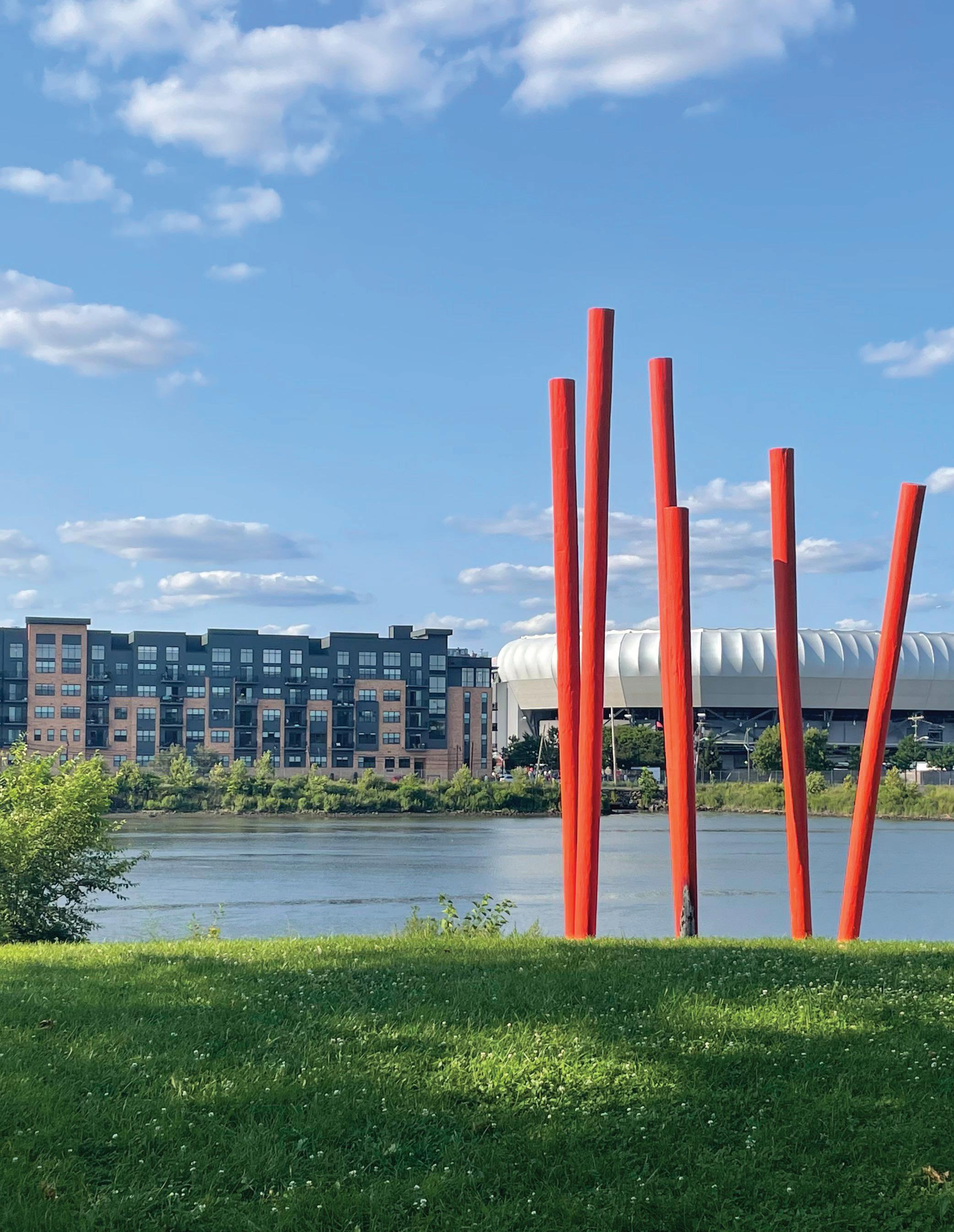
Future Land Use Plan
The Future Land Use Plan establishes a basis for potential zoning ordinance changes, redevelopment plan amendments, and areas to be targeted for future redevelopment projects. The Plan is the technical distillation of the visioning process, goals, and recommendations set forth in the five pillars of the Newark360 Master Plan.
Over the next decade, the following recommendations seek to create a Newark that is healthier, more equitable, and more resilient. The policy recommendations that will inform zoning ordinance and other regulatory changes place people, Newark’s most important asset, at the center of the conversation.
The Future Land Use Plan seeks to:
1. Create new opportunities for housing development that will enable the city to meet its housing goals, create units affordable to people throughout the income spectrum, protect existing Newark residents, and support the most vulnerable Newarkers.
2. Advance Accessory Dwelling Units (ADUs) as a housing typology to create new residential opportunities and advance the city’s housing goals.
3. Consider the elimination of single-family zoning throughout the city, except where it is essential to maintain the historic qualities of designated historic districts.
4. Examine opportunities to establish new historic districts and designate new individual historic sites and landmarks to preserve and respect Newark’s past.
5. Eliminate minimum parking requirements throughout the city and institute parking maximums within proximity to transit to focus new land development on creating space for people to lead healthy, productive, and active lives rather than focusing on dedicating excessive, costly space for vehicle storage.
6. Provide a wider range of locations where small, neighborhood-scale commercial activity can take place. Rather than concentrate economic activity in a few places, each neighborhood should have its own businesses, economic hubs, and local character.
7. Review industrial land uses and locations in which they are permitted to ensure a balance between healthy communities, quality of life, environmental sustainability, and economic activity.
58 | Appendix I.
Future Land Use
C-2N New C-2 Corridor Zoning
DOR - Forward Bound Doremus Redevelopment
ACN - Airport City Newark
Existing Zoning
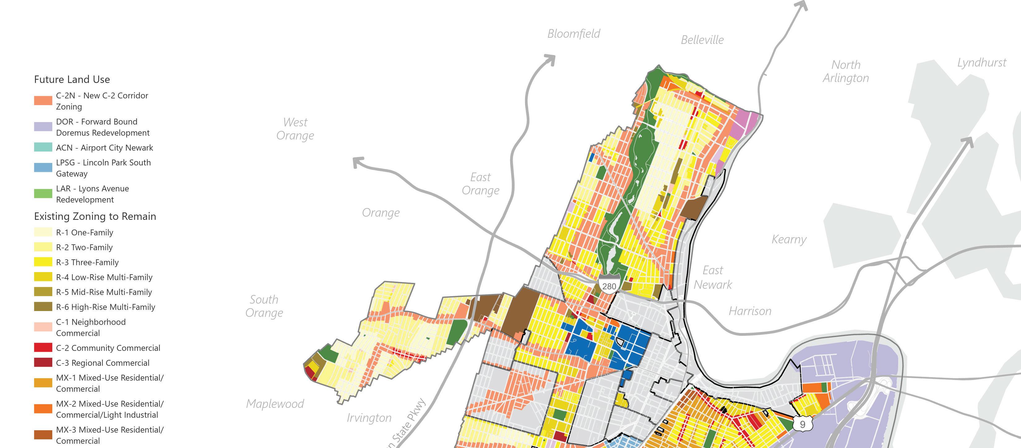
R-1
R-2 R-3 R-4 R-5 R-6 C-1 C-2 C-3 MX-1 MX-2 MX-3 I-1 I-2 I-3 EWR PORT INST CEM PARK RDV
LPSG - Lincoln Park South Gateway
LAR - Lyons Avenue Redevelopment
Proposed Land Use Changes
The Future Land Use Map builds on the existing zoning map to recommend changes that are designed to promote the city’s goals of providing new market-rate and affordable housing units and creating a vibrant, sustainable, and inclusive economy throughout each of Newark’s five wards. The Future Land Use Map reflects the areas where zoning changes or potential redevelopment activity area proposed. In addition to the areas that may be rezoned, changes to standards associated with existing zones and building types are proposed to further the city’s land use goals. Neighborhood-scale Future Land Use Maps are included at the end of the Element.
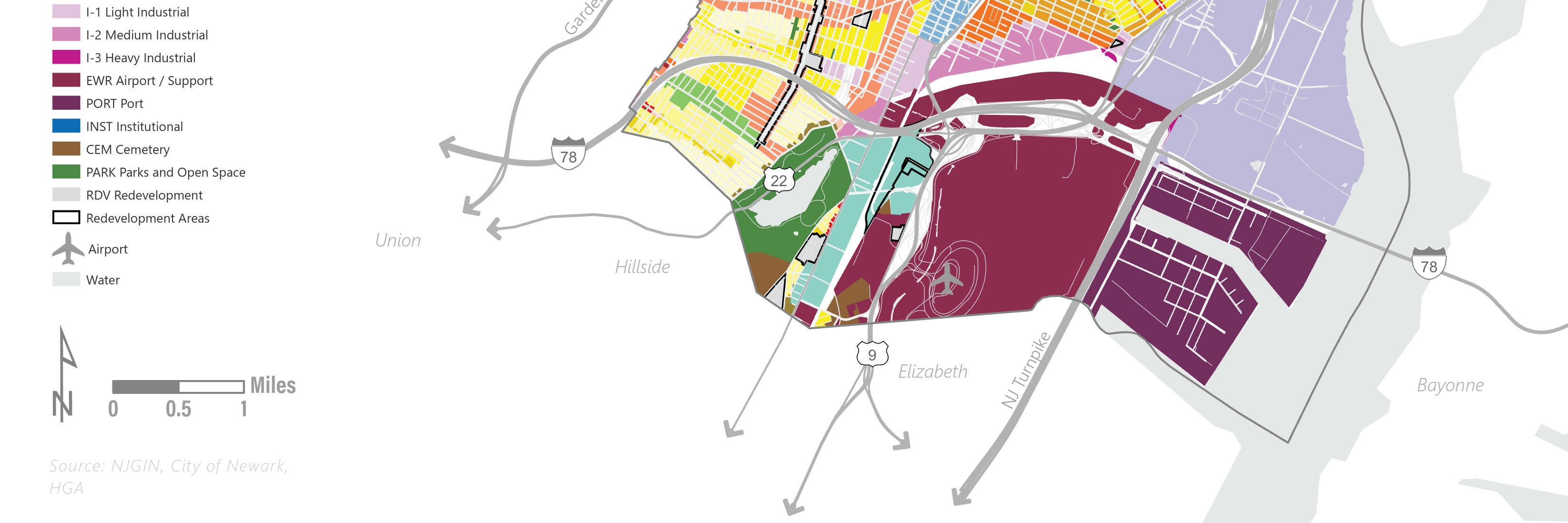 Figure 10 Future Land Use, prepared by HGA
Land Use Element | 59
Key Corridor and Transit Hub Residential and Mixed-Use Strategy
The trends and activity and the Central Planning Board and Zoning Board of Adjustment since 2015 show that most development approvals for the highest volume of units have been received in the Central and East Wards. The Central Ward contains several major redevelopment plans and other areas zoned for multi-family and mixed-use development. The East Ward also has substantial areas zoned for at least four-story developments. The North and South Wards have seen relatively low development activity as there are limited areas where new multi-family or mixed-use projects can be built. The West Ward has seen a proportionally higher volume of applications to the Zoning Board of Adjustment to permit multifamily developments.
Much of the Central Ward is subject to redevelopment plans that already provide significant development potential. The East Ward is densely built out and also subject to a mix of zoning and redevelopment plans that permit robust development opportunities. Furthermore, the East Ward is the most severely flood impacted portion of the city, so until a comprehensive strategy of physical interventions can be planned and implemented, increasing the development density in that area is not prudent.
As part of the broader strategy of promoting housing production in each ward, the Future Land Use Plan recommends extending and modifying the C-2 zone to permit mixed-use and residential developments of six to eight stories along the city’s mixed-use and commercial corridors and near transit stops. An area extending approximately 250-300 feet from the following corridors will be considered for rezoning to the modified C-2 zone, which will also be amended to permit additional height and residential density:
● Bloomfield Avenue (North)
● Broadway (North)
● Franklin Avenue (North)
● Verona Avenue (North)
● Orange Street (Central and West)
● Central Avenue (Central and West)
● South Orange Avenue (Central and West)
● Springfield Avenue (Central and South)
● Clinton Avenue (Central and South)
● Elizabeth Avenue (South)
● Bergen Street (South)
● Lyons Avenue (South)
● Sanford Avenue (West)
The same zoning will also be applied to areas outside of established redevelopment areas within three to four blocks of Newark Light Rail stops.
A supplemental tool that can help balance the increased development pressures with the existing neighborhoods is a system of density bonus standards. The future zoning could include a sliding scale of maximum height and density standards. The highest standards would only be eligible for projects that meet certain thresholds, which may include enhanced sustainability and resiliency elements, publicly accessible open space, community centers, and other similar benefits.
It is important to note that the proposed zoning changes will allow the existing development pattern to remain, while enabling greater flexibility in what can be built in the future.
60 | Appendix I.
Airport City
The Newark Airport City project is a long-term planning exercise that has been undertaken by academic institutions (NJIT, Rutgers, UPenn) the Regional Plan Association, the City of Newark, and other key stakeholders and partners. The Airport City concept centers Newark Liberty International Airport as a hub of activity and investment that can catalyze transformation in the South Ward. The planning focuses on how to create public access to the NJ Transit Newark Airport train station and how to capitalize on potential redevelopment opportunities for properties in its vicinity with a mix of residential units, job opportunities, enhanced circulation, connections to Weequahic Park, and resilience and climate adaptation measures.
An area in need of redevelopment investigation followed by a comprehensive redevelopment planning process may provide the best tools to advance the airport city concept from a land use perspective.
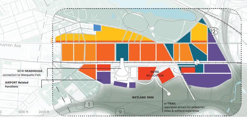 Figure 11 Conceptual Airport City redevelopment (Airport City Newark)
Land Use Element | 61
Citywide Prosperity
● Define and permit a wider range of home-based businesses in all residential zones. Models such as those from Nashville should be considered as case studies. Flexibility should be encouraged to account for non-traditional living and working arrangements, physical and virtual home-based occupations, and artist and light manufacturing maker spaces. Limitations on home-based businesses should focus on life-safety and environmental concerns – for instance, any activity requiring permitting from NJDEP should not be permitted as a home-based business.
● In addition to home-based businesses, a wider variety of non-residential activity should be permitted in residential zones. Medical uses and community facilities may be appropriate throughout residential areas. Neighborhood commercial uses can anchor corners and provide needed services at the local scale to spread economic opportunity throughout the city’s neighborhoods.
Industrial Uses
● The city’s port industrial area in the East Ward is one of the areas that is most vulnerable to climate change, sea level rise, and extreme weather events. At the same time, it is a major driver of pollution, emissions, and air quality impacts through truck traffic, energy generation facilities, and other heavy industrial uses. The Forward Bound Doremus Redevelopment Plan proposes a new set of standards for the area. The Plan is in draft format and is expected to be completed and adopted shortly. Key issues include:
• Area-wide circulation improvements to improve traffic flow and create safer conditions.
• Infrastructure and utilities to promote the electrification of vehicle fleets for warehousing and logistics businesses that support Port Newark.
• Site-specific and area-wide interventions to make the area more resilient to flooding. The recommendations from the Resilient Northeastern New Jersey plan are reinforced by the Newark360 Plan and Land Use Element.
• Promoting green industries that generate economic activity to the benefit of the city’s tax base and provide high-quality, permanent jobs for city residents.
• Continued clean-up and remediation of historic brownfield sites in the area and elimination of noxious industrial uses.
● Warehousing, distribution, logistics, truck and trailer parking, container storage, and other similar land uses are vital to support the ecommerce-based economy that has continued to grow nationwide.
Throughout New Jersey, municipalities are struggling to maintain a balance between a strong tax ratable base and the environmental externalities associated with traffic volumes that accompany logistics facilities. Newark’s port and airport represent important opportunities for collocation of logistics facilities, but there is concern about truck traffic in overburdened environmental justice neighborhoods throughout the city, particularly in the East Ward. In an attempt to balance land use considerations, the following zoning changes are recommended:
• Establishing definitions for distinct types of logistics facilities based on the types and volumes of traffic they generate.
• Remove large-scale warehousing and distribution facilities from the list of permitted uses in the MX-2 and I-1 zones, which create a gradient of uses to buffer dense residential areas of the East Ward from heavier industrial uses and allow for smaller light-industrial uses. Depending on the range of definitions developed, small-scale logistics facilities may be appropriate in these zones.
• Planning for the Forward Bound Doremus Area and other medium and heavy industrial zones should identify how to continue to support the logistics industry without negative impacts on Newark’s residents.
62 | Appendix I.
• Consider defining and permitting urban core distribution facilities that rely on smaller electric vehicles and e-bikes with minimal truck traffic volumes closer to commercial corridors and mixed-use neighborhoods. There are considerable energy consumption, CO2 emission, and traffic safety benefits to using smaller vehicles for local deliveries.
• Small-scale, light-industrial uses such as makerspaces, artisan manufacturers, and similar facilities should be permitted in a mixed-use zones and potentially as home-based businesses with performance standards.
• In order to promote environmental justice and mitigate the historic impacts that heavy industry has had on Newark, the definition of heavy manufacturing and industrial uses should be reviewed to prohibit a wider range of uses that have detrimental impacts on the wellbeing of Newark residents. In addition, as part of the Forward Bound Doremus redevelopment planning effort, the areas in which heavy manufacturing and industrial uses are permitted should be reduced.
Figure 12 Drone flight data reveal energy and greenhouse gas emissions savings for very small package delivery (DOI: https://doi.org/10.1016/j.patter.2022.100569)
Land Use Element | 63
Density and Height Standards
Expanding locations where multi-family housing is permitted and increasing residential density is a critical step toward meeting the city's housing goals, creating affordable and market rate homes, and reducing the backlog of applications at the city’s Zoning Board of Adjustment (ZBA), where about half of the applications are related to either types of residential use or density. ZBA applications tend to be complicated and deliberative, so a high volume creates a substantial strain on the volunteer board, city staff, and the development community. Re-aligning the NZLUR to reduce the number of applications that require ZBA review is good planning practice and will be beneficial to the city.
The current NZLUR regulates density using a minimum lot area per dwelling unit requirement. The standards are linked to different building types, so in zones that permit multiple building types, there are potentially different residential density standards. To regulate density more consistently within zones and throughout the city, the following changes to the NZLUR should be considered:
● Regulate density based on zone district rather than building type and review all density standards to ensure that they are consistent with best practices, typical unit sizes, and desired housing production.
● Reduce minimum lot area requirements and minimum lot area per dwelling unit requirements in R-2 and R-3 Zones to permit as-of-right development on undersized lots and to permit two-family dwellings on 2,000 square foot lots and three-family dwellings on 2,500 square foot lots.
● Review the R-1 Zones and up-zone the portions of those zones located outside historic districts that rely on single-family residential development patterns to maintain their historic qualities. Changes to R-3 or R-4 zoning should be evaluated and considered within each neighborhood context.
● Revise the definition of site plan to exempt threefamily dwellings. This will allow administrative approval of three-family dwellings throughout the city provided no other zoning variance relief is required.
● The concept of density bonuses should be considered, including a review of examples and best practices to determine the most effective way to balance the interests of developers with the need to build equitable and sustainable neighborhoods throughout the city.
● Within the corridor-based mixed-use districts, a density standard of 150 to 250 square feet of lot area per dwelling unit should be considered, which would permit between 175 and 290 units per acre. A sliding scale could be implemented that offers density bonuses if certain community benefit or sustainability enhancements are provided.
● Where the current NZLUR permits mixed-use or multi-family residential development, the most common height limit is four-stories for “Low-Rise” multi-family, which is permitted in the R-4, MX1, and MX-2 zones, and five-stories for “Ground Floor Commercial with Residential Above,” which is permitted in the C-2, MX-1, and MX-2 zones. In order to maximize building and market efficiencies and promote the development of additional housing units, it is recommended that the multi-family and mixed-use building types be re-defined to permit up to six stories in a wider range of areas throughout the city, consistent with the Future Land Use Plan.
64 | Appendix I.
Parking
To advance the Newark360 objectives related to health, equity, resilience and to promote housing affordability, the Future Land Use Plan recommends eliminating minimum parking requirements throughout the city.
Parking is an expensive component of land development and a major use of space in urban areas. During the Master Plan process, members of the development community explained that there are significant costs associated with building and providing parking spaces, and that they are often observed to be underutilized after developments are built and occupied. The raw cost of a single structured parking space in an urban area tends to exceed $50,000, while providing one parking space per unit can increase moderate-priced housing costs by about 12%.
The Newark Zoning and Land Use Regulations should be updated to eliminate minimum parking requirements throughout the city. In addition, the redevelopment plans should be individually amended to reflect the citywide policy so there is not a patchwork approach to parking requirements.
Further study should be undertaken to establish appropriate maximum parking requirements in areas that are well-served by transit. The current residential minimum requirements may be an effective baseline for future maximum parking standards. In addition, there is precedent for parking maximums in the Broad Street Station Redevelopment Plan, which could provide additional guidance. As with the parking minimums, the NZLUR and redevelopment plans should be updated to reflect maximum parking standards.
Bicycle and Micro-Mobility Parking
As a complement to the elimination of vehicle parking minimums, new requirements for bicycle and micro-mobility parking should be implemented. The current bicycle parking standards should be increased to at least 0.5 spaces per residential unit. The bicycle parking should be provided in secure and dedicated areas. Parking and charging infrastructure for scooters, electric bikes, and other similar emerging micro-mobility options should also be considered as a requirement for all new and substantially rehabilitated buildings.
Electric Vehicle Charging
The statewide model electric vehicle service equipment ordinance should be integrated into the NZLUR. The optional sections of the ordinance should be reviewed and modified to suit the city’s needs if applicable.
Land Use Element | 65
Vacant and City-Owned Property
City-owned properties represent a significant opportunity to create additional affordable housing, provide new parks, recreational, and open space opportunities, and provide needed stormwater management and resilience facilities. Analysis done by city staff in 2019 and Invest Newark in 2020 indicates that there are about 1,875 vacant, city-owned properties and over 4,600 total vacant properties. The Newark Land Bank, managed by Invest Newark provides a tool that can effectuate the transfer of those vacant properties to private entities. It is recommended that the city employ the following strategies to leverage the potentially transformative resource at its disposal:
● Where larger sites are available, redevelopment planning may be appropriate to develop concepts with community-based input that can catalyze change. Where appropriate, a request for proposal (RFP) process may be used to solicit development proposals and vet potential development partners.
● The disposition of city properties should provide opportunities for pocket parks and other open space and recreational amenities in underserved areas. Resilience and stormwater management improvements can also be targeted to city-owned properties in areas that are most vulnerable to flooding and climate change impacts.
● When the city or Land Bank transfers property for specific purposes, there should be communication with the Office of Planning and Zoning to ensure that the desired end use aligns with existing zoning, so the development is as close to “turnkey” as possible.
● As a way to support small-scale local developers and potential homeowners, the city should consider partnering with architects to prepare stock plans that are pre-approved to expedite the review and approval process for zoning and building permits for two- and three-family buildings.
66 | Appendix I.
Vacant Parcel Parcel with Vacant Building
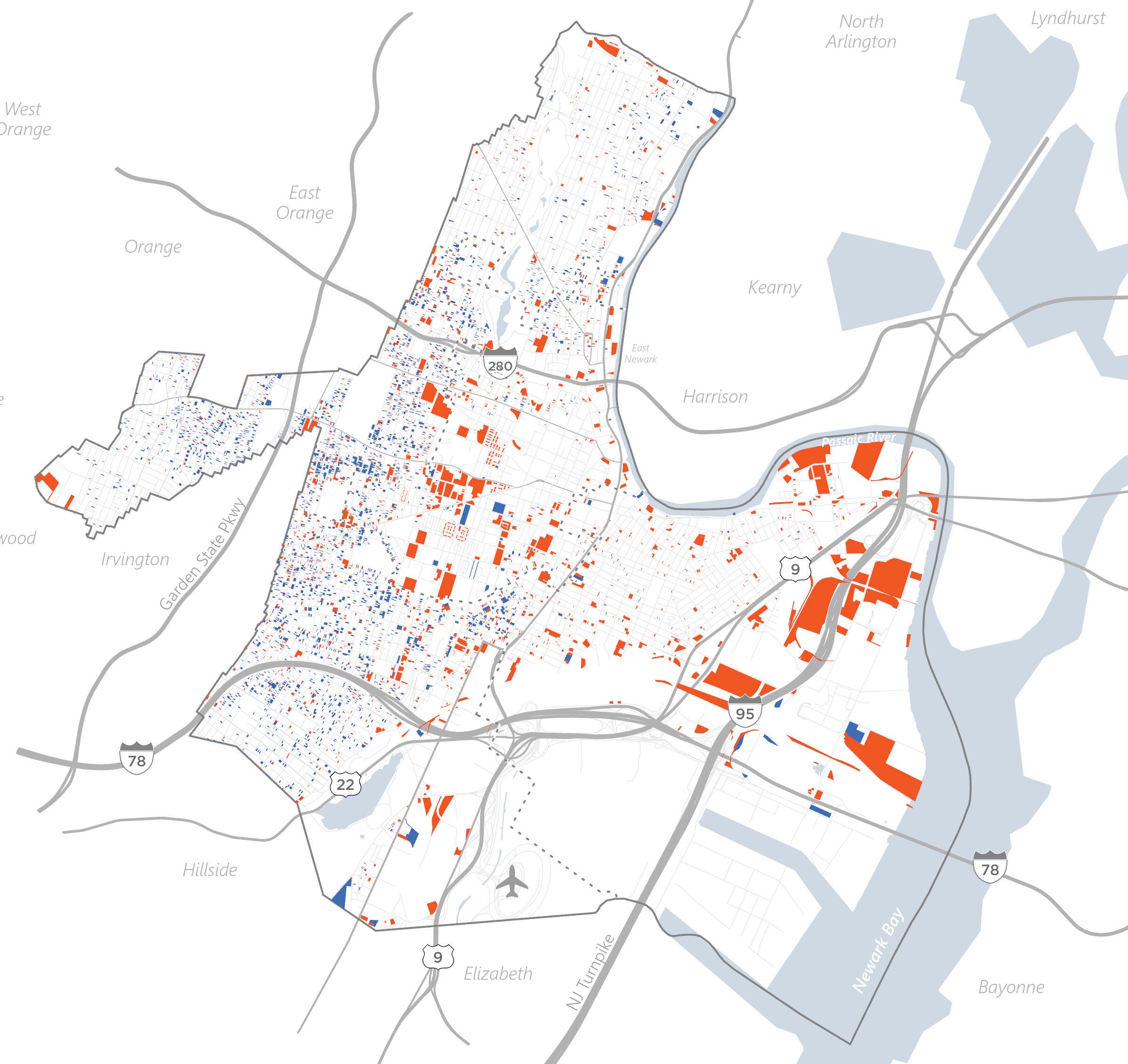 Legend
Figure 13 Vacant Land & Buildings (City of Newark, Reinvestment Fund)
Legend
Figure 13 Vacant Land & Buildings (City of Newark, Reinvestment Fund)
Land Use Element | 67
Special Districts and Hubs
In June 2022, Mayor Baraka announced plans for the creation of an Arts and Education District centered around the downtown area to support and capitalize on the Newark Museum, NJPAC, Newark Symphony Hall, Rutgers-Newark, NJIT, the Prudential Center, Seton Hall Law School, Newark School of the Arts, and Mulberry Commons Park. The District is not explicitly related to land use and zoning, but as part of the broader effort to promote arts, education, economic development, and activity downtown, it is critical that the applicable zoning and redevelopment plans be updated where needed to permit the variety of activity envisioned by the Arts and Education District.
Other potential districts and hubs that warrant further planning study and analysis include:
● Green Zones – Green Zones are a potential designation for environmental justice in environmentally overburdened neighborhoods. Newark360 envisions the potential designation of these areas as a community-led effort that is designed to bring resources to bear on addressing negative externalities around air quality and other pollutants. The Land Use Element acknowledges that zoning modifications may be appropriate in areas designated as green zones.
● Resilience Hubs – Creating resilience hubs, which are locations that provide physical and social infrastructure to educate the public, improve emergency management, and enhance community resilience. The Resilient New Jersey project identified a location for a potential resilience hub in the Ironbound Neighborhood. The Land Use Element reinforces the goal of creating a city-wide distributed network of resilience hubs to serve all Newarkers.
● Mobility Hubs – The Newark360 Plan recommends creating mobility hubs within each neighborhood. Mobility hubs are locations where resources can be marshaled to address inequitable access to jobs and provide a variety of transportation options. The Land Use Element acknowledges that the location of future mobility hubs may create areas that can support increased intensity of land use. Properties within a quarter or half mile of future mobility hubs should be zoned for mixed-use and multi-family residential development that can symbiotically support, and benefit from the mobility hub.
● Historic Districts – The Newark360 Plan identifies areas that could warrant evaluation for the creation of new historic districts in the city.
68 | Appendix I.
1.
Existing Historic Districts
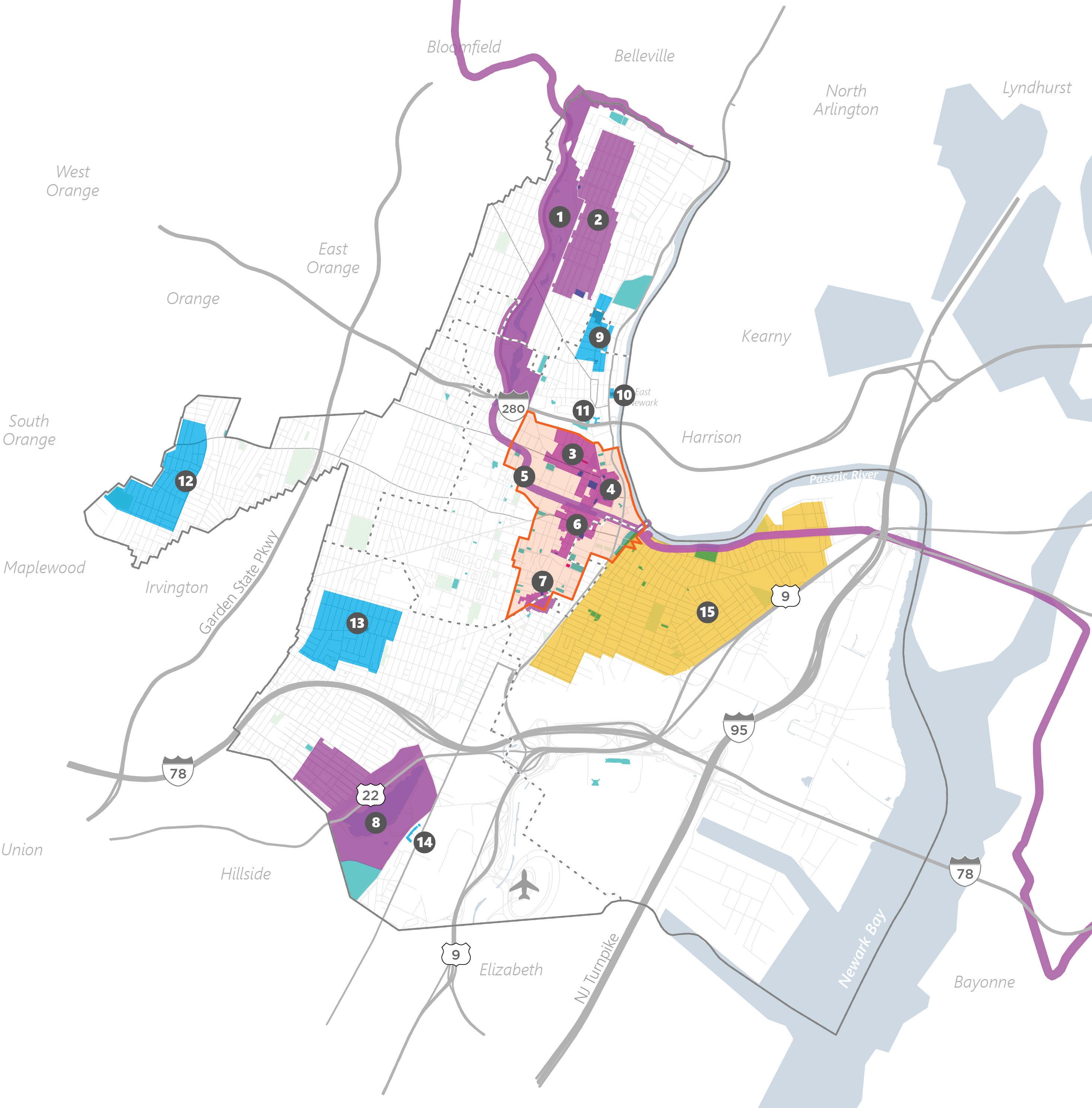
Listed Historic Property
National Historic Landmark
Proposed Historic District
Arts & Education District
Brook Park
Hill
Figure 14 Current & Proposed Historic and Cultural Districts (City of Newark)
Branch
2. Forest
3. James Street Commons 4. Military Park Commons(National Register) 5. Morris Canal 6. Four Corners 7. Lincoln Park 8. Weequahic Park 9. Broadway 10. Watts Campbell 11. Grand Street/8th Ave 12. Vailsburg 13. Clinton Hill 14. Dayton Street 15. Ironbound Legend
Land Use Element | 69
Zoning Recommendations
In addition to the broader future land use recommendations, the Land Use Element supports the following specific, technical recommendations for review and amendment of the Newark Zoning and Land Use Regulations and redevelopment plans.
The Newark Zoning and Land Use Regulations (NZLUR) was adopted and codified as Title 41 of the City code in February 2015. Based on the lessons learned (see existing zoning section) and the evolution of the city since the 2012 Master Plan, a set of technical zoning changes are appropriate to continue to promote positive growth and development in a manner consistent with the city’s goals and vision for the future.
Specific Zoning Recommendations
Uses
● Neighborhood Commercial uses should be evaluated within residential districts. These uses may be most appropriate as a conditional use on corner lots.
● Review and expand the definition of urban agriculture to permit a full range of agricultural activities and appropriate accessory uses.
● Review institutional zone uses to ensure that public / private recreational space is permitted and that the appropriate complementary range of uses is permitted.
● Define single-room occupancy (SRO) facilities, that include supportive services, in a manner similar to community residences as defined in the MLUL, with up to 15 beds. These types of facilities should be permitted in the R-1 through R-4 Zones. Consider definitions for larger SRO buildings and appropriate zones or redevelopment plans where they may be located.
● Modify the standards for mixed-use buildings to permit residential units on the ground floor to account for ADA accessibility in smaller buildings that cannot support elevators.
● Wireless communications antenna standards should be reviewed for consistency with current best practices and FCC regulations. The application and approval process for collocation and modifications to existing sites should be clarified and streamlined. The standards for new installations should be updated.
● Review light industrial definitions:
• Remove warehousing and distribution from the I-1 zone.
• Define additional categories of warehousing and distribution based on industry trends. Differentiate between last-mile facilities with fleets of smaller vehicles and trans-shipment, high cube, and port-based facilities that rely on tractor trailers. Urban distribution models that rely on smaller vehicles, cargo bikes, and other similar modes of transportation can also be defined and permitted in appropriate locations.
• Permit non-nuisance light manufacturing in commercial areas and create a home-based industry category.
70 | Appendix I.
● The following uses should be reviewed and defined. In some cases, existing definitions should be modified, and the location in which the uses are permitted should be reviewed and expanded:
• Makerspace
• Live Work
• Temporary uses
• Pop-Up
• Incubators
• Dancing, nightclubs, bars, cigar lounges, hookah bars
• Art galleries, studios, and similar flexible spaces
• Event spaces
• Catering halls / banquet halls
• Hybrid business models – permit multiple uses within a space
• Resilience Hub
• Mobility Hub
• Medical facilities
General Ordinance Changes
● Exempt ramps and other facilities necessary for accessibility from residential setback requirements
● Consider reducing or abolishing minimum lot size requirements throughout the city. Eliminating minimum lot size requirements can provide creative use of smaller parcels or allow subdivision of smaller fee-simple lots for individual homes.
● Where minimum lot-size requirements remain, existing lots should be “grandfathered” or exempt from lot area requirements provided all other bulk conditions can be met.
• For undersized lots, a percentage-based setback requirement for rear yards may be appropriate to provide adequate building envelope on lots with less depth.
● Review building types – there are uses that do not fit cleanly into some of the available categories, which makes it difficult to know which standards to apply. Consider creating a set of building standards applicable to an “all other permitted uses” category for each zone.
• Additional clarity is needed, particularly for commercial building types – Ex: is a 2-story commercial building “detached commercial” or “ground floor commercial with commercial above.”
Land Use Element | 71
● Review all density standards. The current “lot area per dwelling unit” requirement should be revised to permit additional density throughout most parts of the city and should be based on the zone rather than the building type.
• For instance: in the R-5 zone, “Low-Rise Multi-Family” and “Mid-Rise Multi-Family” are both permitted. If a building is four stories or fewer, it is considered “low-rise”. At that height, a minimum of 625 square feet of lot area is required per unit (+/- 70 units per acre). If a building is five to eight stories (a “mid-rise”) then a minimum of 350 square feet of lot area is required per unit (+/- 125 units per acre). The permissible density should be based on zone districts rather than building types.
● Clarify which standards are minimums and which are maximums – the language in the standards is not applied evenly.
● Review impervious coverage standards – the separate front yard and rear yard breakdown may not be serving its purpose, particularly for projects that have no front or rear yard area. Adjustments should consider the interplay between parking standards and impervious coverage standards.
● Require the use of permeable paving materials for most impervious yard areas. Consideration should be given to an impervious coverage “discount” for permeable pavers / paving materials. There are potential maintenance issues that diminish the effectiveness of permeable paving materials for longterm stormwater management purposes. Additional review and consultation with the engineering department should be undertaken before deciding.
● Review the building transparency requirements. The building transparency requirements are a tool that was put in place with the February 2015 ordinance to reduce blank facades and provide “eyes on the street” throughout the city. There are frequent variance requests for deviation from the transparency standards, so a review and “calibration” should be undertaken to balance the goal of the standard and the practicality of the requirement.
● Conduct a full review of Chapter 16 Zoning and Design Standards to make sure that they are clear and consistent with best practices.
• Lighting • Landscaping
• Fence height (currently 3’ / 5’ – 42” / 6’ may be more appropriate)
• Additional review of which standards require variances, and which are waivers
● Signage - A comprehensive review and update of the signage standards (Chapter 9) should be undertaken. The review should include, but not be limited to the following:
• Clarify signage standards for multi-tenant retail buildings to permit appropriate signage for each separate storefront.
• Define and regulate electronic message center signs.
• Include general signage standards that apply to building types that may not fit in one of the prescribed categories.
• Review the definition and regulation of temporary signage and update as needed.
● Review locations where utilities are permitted. Currently utilities are not well defined, and some essential facilities are not permitted in most of the city. A review of utilities and their potential impacts should be undertaken to identify larger areas where they are permitted and/or conditional use standards to permit them as a way to offset impacts.
● The NZLUR includes a section defining “Extraneous Living Space” as a method to combat illegal conversions of basement and attic spaces to residential units. This section should be reviewed to ensure that it is serving its intended purpose of protecting the public welfare from unsafe living conditions and creating a burden on property owners that overly restricts the use of their space
72 | Appendix I.
Process Recommendations
● Chapter 15 of the NZLUR should be reviewed and updated to modify the requirements for site plan approval and clarify exemptions.
• Change of use applications to permitted uses that do not involve construction should be exempt from site plan approval.
• The division of commercial spaces within existing footprints that do not involve construction should be exempt from site plan approval.
• The creation of residential units within smallscale non-residential buildings should be exempt from site plan approval. Currently adding one or two apartments above a ground floor commercial space is exempt. The threshold should be raised to permit more flexibility and administrative approval of infill conversions.
● The NZLUR should be amended to include a process for administrative approval and monitoring of temporary uses. A definition of “temporary” should be created and a clear process for review and approval developed. Uses could be defined as monthly, seasonal, annual, or some other defined period of time.
● The Environmental Justice and Cumulative Impacts Ordinance provides an opportunity for technical review by the Environmental Commission. It is recommended that resources be provided, which may be funded by application escrow, to provide the Environmental Commission with expert staff including environmental scientist / engineer, certified floodplain manager, arborist, and other appropriate specialists to assist with timely preparation of reports.
Land Use Element | 73
Sustainability and Resiliency Recommendations
● It is recommended that a new set of sustainability and resiliency standards be developed and integrated into the NZLUR consistent with national best practices for other high-risk coastal communities, particularly those that include large vulnerable industrial areas.
● The stormwater management ordinance should be updated to be consistent with the most recent state standards that went into effect in 2021. The updated stormwater management ordinance should incorporate higher standards than the statewide minimums.
• One such standard may be to reduce the threshold for major developments to projects that include impervious surfaces of 5,000 square feet or more.
• A Green Area Ratio Ordinance (see Jersey City and Washington, D.C.) could be appropriate to require additional green infrastructure with a point system based on the type of best management practice.
● Solar panels should be made a permitted accessory use in every zone district in the city. A distinction should be made between solar panel systems intended to provide electricity for use on-site and utility-scale or community solar projects.
● Tree Planting and Canopy Enhancement
• The existing tree planting requirements in the NZLUR mandate significant numbers of plantings. It is recommended that additional clarity be provided about appropriate exceptions for when trees are not required to be planted and a formal process of documentation that accompanies those requests.
• Where trees cannot be planted in-ground, large-scale planters can be an appropriate alternative subject to adequate sidewalk widths and city approval.
• Variances that permit payments to the Tree Fund in lieu of planting should be discouraged.
• A more active role for the city arborist is recommended.
•
It is recommended that an urban forestry plan with specific recommendations, a spending plan, and a dedicated budget and funding stream be prepared.
● The flood damage prevention ordinance should be reviewed and optional higher standards incorporated. The Resilient New Jersey work and other best practices include appropriate guidance for how to promote more resilient development within flood hazard areas.
•
It may be appropriate to require Environmental Commission review under the Environmental Justice and Cumulative Impacts Ordinance of any project in the flood hazard area.
● Design or zoning standards should be considered to require that any roof over a certain size threshold be required to incorporate one or more of: solar panels or other renewable energy installation, cool roof, or green roof.
● A green building chapter that includes standards, requirements, or best practices derived from rating systems like LEED, EERE’s Zero Energy Buildings, Passive House, or others can be integrated into the NZLUR.
● The Future Land Use Plan recommendations related to permitting increased development density are focused outside the portions of the city subject to the most climate and extreme weather-related vulnerabilities. Newark360 recommends pursuing a climate adaptation / resilience plan for the East Ward that builds on the Resilient Northeastern New Jersey recommendations. Until that work has been advanced and a plan for long-term resilience established, land use changes that potentially increase development intensity are not recommended for that area.
74 | Appendix I.
Inclusionary Zoning
In 2022, the city was in the process of amending its inclusionary zoning ordinance. Providing affordable housing units is consistent with the city’s broader goals and objectives; particularly the housing production targets. It is recommended that the Division of Economic and Housing Development monitor the impacts of the amended ordinance in terms of total housing starts, market rate units produced, affordable units produced, and the geographic distribution. Quarterly (or more frequent) updates to benchmarks and monitoring can demonstrate the impacts of the ordinance and inform the evolution of policy and land use regulations in the city.
Land Use Element | 75
Redevelopment Plan Recommendations
Different plans of different vintages are not necessarily aligned on some important issues. Comprehensive, city-wide considerations that need to be addressed, potentially throughout all plans include:
● Transportation Improvements
● Green / Complete Streets standards that are consistent citywide.
● Affordable housing obligations should be applied throughout the city with the understanding that redevelopment plans could mandate different standards.
● Community benefit agreements should be considered with specific projects identified within redevelopment areas that can be advanced by redevelopers. One tool could be to require a development fee that can be used for resilience, open space or arts improvements within the redevelopment area.
Broad Street Station
● There are some internal conflicts and inconsistencies about height requirements based on street frontages and other similar standards. The standards in the Plan should be reviewed and updated to clarify the existing requirements to prevent future confusion.
Living Downtown
● Review the permitted uses to ensure that they are consistent with the goals of the Arts and Education District and creating a 24/7 city.
• Bars, nightclubs, dancing, event spaces, galleries, etc.
● Medical uses are currently not permitted in retail storefronts. It may be appropriate to revise the plan to permit medical uses in a wider range of areas.
Kent Brenner Springfield
● Review districts and expand mixed-use areas to be consistent with overall corridor-based concepts elsewhere.
Specific Redevelopment Plan Recommendations
All of the older redevelopment plans should be reviewed and updated to include solar panels as permitted accessory uses and permitted or conditional principal uses where appropriate. Other global changes should include modification to parking standards to be consistent with the elimination of citywide minimums and the institution of maximums near transit. Where other similar conflicts occur between the newer zoning ordinance and best practices and older redevelopment plans, the redevelopment plan standards should be eliminated or updated to be consistent with best practices.
● Consider standards similar to those in the West Ward MNI that permit two- and three-family dwellings on smaller lots.
West Market / Northern Fairmount
● The zoning standards in the Northern Fairmount Redevelopment Plan should be revisited for consistency with the corridor-based strategy of increasing permitted residential density and height.
River Redevelopment
● The River Redevelopment Plan is focused largely within the Ironbound Neighborhood. It is recommended that the Plan be reviewed to include additional standards related to resilience and physical infrastructure improvements.
● The Plan has been amended four times. It is also recommended that all of the amendments be integrated into a cohesive plan document.
76 | Appendix I.
Downtown Core
● The Downtown Core Plan is mostly based on specific redevelopment concepts for block-scale parcels for which redevelopers are designated, and for which there are binding redevelopment agreements.
● It is recommended that the Plan be reviewed to determine which project sites are legally designated, and which portions of the Plan could potentially be amended. For any blocks that can be amended, a more general, less restrictive regulatory program may be appropriate.
Old Third Ward
● The Old Third Ward Plan dates to the 1960s and has been amended piecemeal 21 times. It may be appropriate to undertake an updated planning review of the area covered by the Plan. A modernization and comprehensive update may be appropriate.
● The neighborhood to the west of the Old Third Ward boundary contains potential redevelopment sites that may benefit from inclusion in a broader planning effort. The expansion of the Old Third Ward Plan to encompass these areas, or the development of a new plan that supersedes and absorbs the Old Third Ward Plan could be beneficial.
South Bergen
● It is recommended that the use, bulk, and density standards along Bergen Street be reviewed for consistency with the broader corridor-based Future Land Use Strategy. Bergen Street is an important link between Clinton Avenue and Lyons Avenue – each of these corridors should have consistent development potential to support the South Ward neighborhoods.
Land Use Element | 77
Proposed Potential Redevelopment Areas
Forward Bound Doremus
The Forward Bound Doremus Redevelopment Plan is in a working draft stage. The Plan proposes standards that will promote a more sustainable and resilient industrial area within Newark’s East Ward. The area covered by the Plan is generally east of the Ironbound Neighborhood and encompasses the traditional heavy industrial part of the city, which is mostly zoned I-3.
Dayton Neighborhood / Airport City
It is recommended that the city investigate the possibility of redevelopment designations and planning for additional portions of the Dayton Neighborhood. The former Seth Boyden Homes property, which is owned by the Newark Housing Authority, was designated as an area in need of redevelopment and is currently targeted for mixed-use redevelopment with a movie production facility and residential units. The areas to the north and south along Frelinghuysen Avenue may be appropriate for further investigation and redevelopment planning around the Airport City concept.
South Lincoln Park Gateway
The South Lincoln Park Gateway Redevelopment Plan was drafted in 2019 and 2020, but its adoption was stalled in part due to the Covid-19 pandemic. The Plan focused on the area centered on Broad Street south of Lincoln Park with a focus on creating an improved gateway to the city from the surrounding highway network. It is recommended that the Plan be revisited and considered for future adoption.
Lyons Avenue / Beth Israel Hospital
The city recently designated an area in need of redevelopment in the South Ward along the Lyons Avenue corridor focused around Beth Israel Hospital. It is recommended that the city continue the redevelopment process by developing a redevelopment plan in collaboration with the hospital and other community stakeholders.
78 | Appendix I.
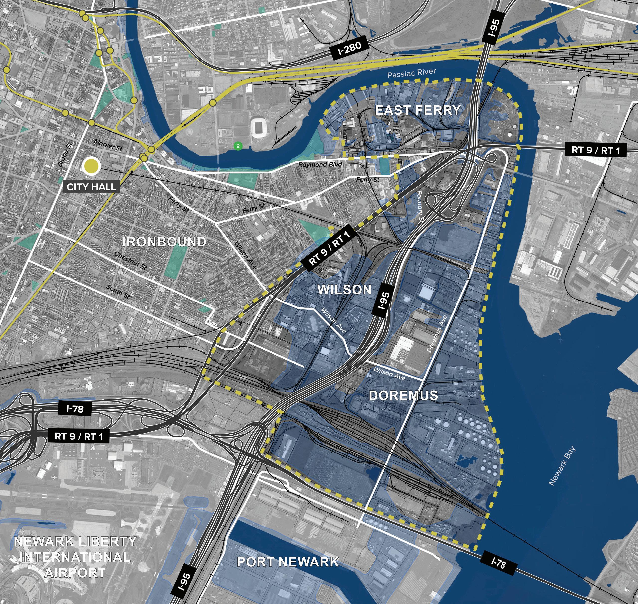 Figure 15 Forward Bound Doremus Redevelopment
Land Use Element | 79
Statements of Strategy
Smart Growth
The entire city of Newark is located in the State Development and Redevelopment Plan Metropolitan Planning Area (PA1). The city is also designated as one of the state’s urban centers. The city is well served by transit and has walkable, mixeduse neighborhoods. The Future Land Use strategy envisions increased residential density in mixeduse neighborhoods along important corridors and around transit stops. In addition, parking minimums will be reduced or eliminated to promote more efficient use of land, housing affordability, and an increase in transportation options. Each of these strategy elements promotes smart growth through urban redevelopment and infill, reduces vehicle miles traveled, and creates more affordable housing.
Storm Resiliency with Respect to Energy Supply, Flood-prone Areas, and Environmental Justice
The Newark Tomorrow chapter and the Land Use Element recommend that a comprehensive East Ward Climate Resilience Plan be prepared to develop an approach to ensuring a sustainable and resilient future in the Ironbound Neighborhood, the port, airport, and industrial areas in the East Ward.
PSE&G has been working on a comprehensive upgrade and “hardening” of its electric supply and distribution infrastructure in the city. It is recommended that the city continue its engagement with PSE&G as these projects continue to ensure that there is an appropriate balance of environmental justice, aesthetics, public safety, and resiliency.
Environmental Sustainability
The Newark360 Master Plan and Land Use Element include numerous strategies to promote environmental sustainability. The following recommendations from Newark360 are relevant:
1.1.2 – Introduce young Newarkers to opportunities in the local Green Economy.
1.5.5 – Increase green economic opportunities for businesses, including the green business challenge, energy efficiency, fleet deployment and green infrastructure.
3.1.9 – Integrate parks with green infrastructure.
3.6.1 – Advance planning and implementation for Resilient Northeastern New Jersey (RNJ) tools and strategies to address coastal flooding and manage rainfall events.
3.6.2 – Increase permeable surfaces and expand planted areas to combat urban heat island effect and improve stormwater management.
3.6.4 – Incentivize the transformation and restoration of brownfields and contaminated sites.
3.6.5 – Create an East Ward Strategic Climate Adaptation Plan.
4.2.3 – Incentivize retrofits of existing buildings for energy efficiency, indoor air quality, and lead abatement.
4.4.1 – Develop and support a citywide tree canopy initiative.
5.2.2 – Mandate green and blue roofs as part of public building upgrades and retrofit projects.
5.2.3 – Establish standards for new development to include robust stormwater capture.
5.2.4 – Designate priority sites and areas for green infrastructure investment.
80 | Appendix I.
Existing and Proposed Location of Public EV Infrastructure
Since the 2021 amendment to the Municipal Land Use Element and the adoption of the statewide model ordinance, all new development applications in the city have been required to demonstrate compliance with the provision of electric vehicle service equipment (EVSE) and or “make ready” infrastructure if applicable. As the approved developments are constructed, a mix of private and publicly-accessible EVSE will come online throughout the city.
It is recommended that the city pursue funding opportunities and include the provision of EVSE on public property within its capital planning program. In addition, the city should begin phasing electric vehicles into its fleet. Light-duty passenger vehicles and trucks can begin immediate phase-in. The city should monitor emerging trends in battery technology and vehicle development to phase-in heavier electric vehicles when feasible.
Locations for EVSE on publicly owned property include:
● Police precincts and other public safety facilities, including the new facilities being developed on Bergen Street and Irvine Turner Boulevard.
● Department of public works and other properties with large motor pool parking.
● Newark Parking Authority garages and surface lots.
The city should also partner with other entities including Essex County, NJIT, Rutgers, and Newark Public Schools to support the installation of EVSE on their properties.
The city should evaluate appropriate locations for on-street EVSE along commercial corridors.
Land Use Element | 81
Climate Change Assessment
The Newark Hazard Vulnerability Assessment in Appendix II provides a review of existing climate vulnerability, hazards, critical infrastructure and coordination with other plans. The Land Use Element incorporates the assessment by reference and includes the following specific land use strategies, and build-out analysis component.
Land Use Strategies
1. Construct green infrastructure on municipal properties. Green infrastructure can help reduce urban temperatures through shade and evapotranspiration and mitigate flooding through pervious surfaces which reduce runoff.
2. Incentivize the construction of green infrastructure on existing private properties. Offer tax incentives to encourage construction of green infrastructure.
3. Require environmental site design standards including stormwater management infrastructure for new development. Stormwater management infrastructure that reduces impervious surface will help mitigate the impact to Newark’s combined sewer system and reduce flooding.
4. Establish cooling and warming centers across Newark to provide relief from extreme temperatures. Cooling and warming centers ensure even the most vulnerable Newark residents can stay safe during extreme weather.
5. Establish resilience hubs in existing community facilities. Resilience hubs will help reduce the impacts from hazards by helping communities prepare for and adapt to climate hazards.
6. Increase Newark’s urban tree canopy through a tree canopy program. Reduce the ability to seek exceptions to tree planting requirements for private developers, develop and implement a tree planting plan that uses the city’s Shade Tree Fund, and provide dedicated budget to support the maintenance and replacement of trees in the right-of-way throughout the city.
7. Continue implementing Newark’s Long Term Control Plan. The Long Term Control Plan will help manage the quantity of water flowing into Newark’s combined sewer system and reduce the risk of overflow during flooding and storm events through combined sewer overflow storage tanks, green infrastructure, and water conservation .
8. Construct a living shoreline along Newark Bay. The living shoreline would include wetland restoration to reduce flooding along the Passaic River during storm events and high tide.
9. Create a floodplain overlay district limiting new development and increasing adaptation regulations in Newark’s most vulnerable neighborhoods.
a. Establish minimum elevations for critical systems such as boilers, electric panels, generators.
b. Establish a minimum elevation for new construction and renovations of more than 50% of existing buildings.
c. Reduce the permitted amount of impervious coverage.
d. Require green or blue roofs for buildings that exceed a certain size or percentage of lot coverage.
82 | Appendix I.
Build-Out Analysis
The City of Newark has approximately 600 acres of vacant and developable land, which accounts for about 3.6% of the city’s total area. Of the 600 acres, about 74 are within redevelopment areas. In addition to vacant parcels, currently developed lots throughout the city may be subject to short or long-term redevelopment that includes an increase in existing residential units or non-residential square footage.
For the purposes of this analysis, the storm surge extent associated with Superstorm Sandy is used to identify potential future hazards. The Sandy surge extent covers a larger area than either the effective or preliminary flood insurance rate maps (FIRM) prepared by FEMA.
To calculate the possible build-out, properties subject to standard zoning were analyzed for development potential. All developments were assumed to be “as of right” and conform to the lot area, building coverage, and density requirements associated with the zone and/or building types as outlined in the Newark Zoning and Land Use Regulations. Vacant parcels in residential and mixed-use zones can yield approximately 7,800 new residential units. Commercial and mixed-use parcels can yield about 1,500,000 square feet of commercial / retail space. Industrial parcels can yield about 14,100,000 square feet of industrial floor area.
In order to understand risk, the development potential associated with parcels all, or partially within the Sandy surge extent was broken out as a percentage of the overall potential yield. Approximately 16% of the potential residential units, 31.5% of the commercial square footage, and nearly 94% of the industrial floor area are within the Sandy surge extent.
Redevelopment areas, not subject to standard zoning, have additional development / redevelopment potential. It is difficult to quantify the number of potential residential units or building square footage because some of the redevelopment
plans do not have limits on height or density. Furthermore, the nature of redevelopment is such that currently developed parcels may be redeveloped so the universe of theoretical development sites is greater.
The redevelopment areas clustered in the Downtown neighborhood near Newark Penn Station are those with the greatest development potential. There are a limited number of vacant parcels in the Living Downtown, River Public Access and Redevelopment Plan, and Broad Street Station areas that are in the Sandy surge extent. Of those parcels, several have already received approvals and are in the development pipeline. Most of the vacant parcels in the redevelopment areas are located in the Kent Brenner Springfield and West Ward Model Neighborhood Initiative areas. Those areas are not subject to tidal or riverine flooding, but could be impacted by flash flooding and aerial events in low lying areas and locations with sewer infrastructure issues.
The area of greatest concern for direct climate change impacts on future development is generally concentrated in the East Ward. The industrial districts are almost entirely in the flood hazard area. The forthcoming Forward Bound Doremus Redevelopment Plan will encompass a large section of this area and will include higher standards for new development moving forward.
The Airport and Port areas, while not under the city’s jurisdiction, are also vulnerable to climate change and sea level rise impacts.
The Ironbound neighborhood is the most consistently vulnerable part of the city and is densely built up. New development and redevelopments in the Ironbound should recognize the current and future risk and plan accordingly with building and site design elements to mitigate flood risk, enhance stormwater management, and reduce the urban heat island effect.
Land Use Element | 83
Consistency with Other Plans
The Municipal Land Use Law requires that a Master Plan review and include a policy statement about the relationship between the proposed development of the municipality and the following other plans:
1. The Master Plans of contiguous municipalities
2. The State Development and Redevelopment Plan (SDRP)
3. The Essex County Master Plan
4. The Solid Waste Management District Plan
Newark borders thirteen municipalities, five of which are in Essex County, six are in Hudson County, and two are in Union County.
Municipal Plans
Bloomfield Township
Bloomfield Township borders the Northwest edge of Newark along 13th avenue between Second Avenue and Bloomfield Avenue. Bloomfield Avenue is an important commercial corridor through Newark’s North Ward and continues through Bloomfield and beyond. The land uses in Newark and Bloomfield are consistent with commercial uses and mixed-use development along Bloomfield Avenue and generally two- and three-family scale residential developments elsewhere along the municipal line.
The Bloomfield Master Plan was Reexamined in 2014, with none of the recommended land use changes impacting Newark. The most recent Land Use Element amendment was adopted in 2020. That amendment was focused on specific land use changes for several parcels, none of which impact Newark.
Belleville Township
Belleville Township shares a municipal border with Newark along the city’s northern edge in the Forest Hill and North Broadway / Woodside Neighborhoods, and to the northwest of Branch Brook Park. Branch Brook Park, which connects to Belleville Park and abuts the Second River is the defining feature of the municipal boundary.
The area between Broadway and the Passaic River consists of warehousing, logistics, and industrial uses in Newark and similar light industrial and commercial uses in Belleville. The area to the west of Branch Brook Park in Newark is generally commercial enterprises and multi-family housing, which abut similar neighborhoods and the Clara Maas Medical Center in Belleville.
The most recent Master Plan Reexamination Report was adopted in 2021. The Plan identifies the HudsonEssex Greenway, which is proposed to pass through
84 | Appendix I.
both Belleville and Newark as an important regional project. The Reexamination Report also identifies the Silver Lake Light Rail station, which is the northwestern terminus of the Newark Light Rail as a potential Transit Village.
The area around the municipal boundaries is largely built-out or consisting of parks and open space. The land use patterns are generally compatible.
City of Elizabeth
Elizabeth is located to the south of Newark with access between the cities at Frelinghuysen Avenue and Routes 1 and 9. The municipal boundary splits the Port Newark-Elizabeth Marine Terminal and Newark Liberty International Airport. The west edge of the municipal line is adjacent to Evergreen and B’Nai Jeshuron Cemetery and the southern edge of Weequahic Park.
The municipalities have common land use patterns within the port and airport areas, along Route 1 and 9, and within the industrial districts that line Frelinghuysen Avenue.
The most recent Elizabeth Master Plan Reexamination Report was prepared in 2020. The 1029-1061 Newark Avenue Redevelopment Area was identified as a new redevelopment plan. The Area has since been redeveloped into a warehouse that includes access to Virginia Avenue in Newark but is almost entirely in Elizabeth. There are no other recommendations in the Plan that are relevant to Newark.
Hillside Township
Hillside shares a portion of the southern municipal border with Newark adjacent to Weequahic Park. West of Weequahic Park, Elizabeth Avenue changes character as it transitions away from the generally residential uses in Newark to retail and commercial uses in Hillside.
The 2009 Hillside Master Plan recognizes that the Township is largely built out. The existing and future land uses along the Newark boundary are generally consistent between the two municipalities.
Township of Irvington
Irvington has a roughly triangular border with Newark along the southern part of the Vailsburg neighborhood and the western edge of the West Side, Upper Clinton Hill, and Weequahic neighborhoods.
Generally, the two municipalities blend into one another with minimal distinctions in land use. The one exception is the commercial and industrial section of southeast Irvington, generally between Clinton Avenue and Lyons Avenue borders residential neighborhoods in Upper Clinton Hill.
The 2009 Irvington Master Plan Reexamination Report includes a focus on economic development in the area along Clinton Avenue, that is consistent with the development intensity and potential up-zoning along Clinton Avenue recommended in the Future Land Use Plan.
Township of Maplewood
Maplewood borders the southwest corner of the Vailsburg neighborhood along Irvington Avenue and Putnam Street from Eder Terrace to Eastern Parkway.
In Newark, the land uses are mix of low-density residential uses except for a concentration of highrise residential and a shopping center in the Ivy Hill neighborhood, the city’s westernmost corner. The development patterns differ between the municipalities, but they are well established and not likely to change.
Maplewood is currently updating its Master Plan.
Township of South Orange Village
South Orange abuts the western edge of Newark’s Vailsburg neighborhood. In Newark the primarily land uses are commercial and mixed-use residential along South Orange Avenue, Ivy Hill Park, and highrise residential at the Ivy Hill Apartments.
South Orange Avenue continues through the West Ward of Newark and becomes one of the main commercial thoroughfares in South Orange. Seton Hall University is adjacent to the Upper
Land Use Element | 85
Vailsburg neighborhood and is one of the defining developments in the eastern part of South Orange near Newark.
The land use patterns and policies in the 2021 South Orange Master Plan are generally consistent with the existing pattern of development in Newark.
City of East Orange
East Orange shares two of its edges with Newark. East Orange abuts the northern edge of the Vailsburg neighborhood and the western edge of the Upper Roseville neighborhood. South Orange Aveune, Central Avenue, and West Market Street are major commercial and mixed-use thoroughfares shared by the two cities. Holy Sepulchre Cemetery and Fairmount Cemetery both straddle the municipal line and are important local landmarks.
East Orange’s most recent Master Plan was updated in 2018. One of the goals of the Master Plan is to improve gateways to the city. A redevelopment project of the former Arcadian Gardens along Sussex Avenue is identified as an important gateway between East Orange and Newark. The project has the potential to benefit both municipalities.
The area along South Orange Avenue that forms the municipal boundary was identified for rezoning from C-1 to Gateway Commercial. The Master Plan recommends coordinating with the City of Newark to undertake a comprehensive approach to revitalizing South Orange Avenue.
The Circulation Element of the Master Plan recommends evaluating the possibility of a joint bike share program that could include East Orange, Newark, Orange, and South Orange.
The Historic Preservation Element recommends collaboration between Newark and East Orange on the preservation of the cemeteries on Central Avenue and Springdale Avenue.
Harrison Town
Harrison is located north of the East ward and east of the Central Ward across the Passaic River from Newark. The Bridge and Jackson Street Bridges connect the municipalities. The Harrison Waterfront Redevelopment Area has been a twodecade long project to replace former industrial uses with a new mixed-use community anchored by the Harrison PATH station. The land use and development patterns are consistent with the mixeduse patterns in Newark’s Downtown and Ironbound neighborhoods.
Harrison is in the process of developing a waterfront walkway on the north and east sides of the Passaic River that mirrors Newark’s efforts on the south and west sides.
The most recent Master Plan Reexamination Report was adopted in 2020. The most significant land use recommendations dealt with the creation of a TV and Film Studio Overlay and Affordable Housing districts. No significant changes were recommended for the Waterfront Redevelopment Area.
Borough of East Newark
East Newark is across the Passaic River from Newark. The municipalities are connected by the Clay Street bridge. The western portion of East Newark nearest Newark is zoned for industrial and commercial uses, which are consistent with the land use patterns on the Newark side of the river. The Clark Thread Factory redevelopment area is the only significant development or redevelopment opportunity in East Newark.
The most recent East Newark Master Plan Reexamination Report was adopted in 2021. The recommendations in the Reexamination Report do not have any adverse impact on the city of Newark.
86 | Appendix I.
Kearny Town
Kearny is located across the Passaic River from Newark in both the North and East Wards. Across from the North Ward, the land uses in Kearny include regional commercial uses with a grocery store and other “big box” retailers, recent mixed-use redevelopment projects, and a riverfront park. Across from the East Ward is the industrial district of South Kearny that mirrors Newark’s Doremus Avenue area and industrial uses. The land uses are compatible and well-aligned in both locations.
The Kearny Master Plan was most recently amended in 2022. The land use recommendations retain the existing land uses for the portions of Kearny closest to Newark. None of the recommendations have any adverse impact on the city of Newark.
Jersey City
The eastern edge of Newark shares a border with Jersey City along Newark Bay. The municipalities are separated by the water and have no direct connections to each other. Jersey City’s land use policies have no direct impact on Newark’s East Ward, and vice-versa.
City of Bayonne
The eastern edge of Newark shares a border with Bayonne along Newark Bay. The municipalities are separated by the water and have no direct connections to each other. Bayonne’s land use policies have no direct impact on Newark’s East Ward, and vice-versa.
Land Use Element | 87
State Development and Redevelopment Plan
The City of Newark is one of eight “Urban Centers” and is entirely within the Metropolitan Planning Area (PA1) as defined by the State Development and Redevelopment Plan (SDRP). The Plan, while last updated in 2001, remains the effective state plan and includes goals and policies that are relevant to the city.
The following goals are particularly important for Newark and are consistent with the policies set forth in the Land Use Element:
◌ Goal 1 – Revitalize the State’s cities and towns
◌ Goal 3 – Promote beneficial economic growth, development, and renewal for all residents of New Jersey.
◌ Goal 4 – Protect the environment, prevent, and clean up pollution.
◌ Goal 5 – Provide adequate public facilities and services at a reasonable cost.
◌ Goal 6 – Provide adequate housing at a reasonable cost.
◌ Goal 7 – Preserve and enhance areas with historic, cultural, scenic, open space, and recreational value.
Within Urban centers and PA1, the SDRP sets forth the following policy objectives:
1. Land Use: promote redevelopment and development in cores and neighborhoods of centers. Promote diversification of land uses and ensure efficiency and beneficial utilization of scarce land resources.
2. Housing: provide a range of housing choices and the creation of mixed-use districts.
3. Economic development: promote strategic land assembly, infill development, public/private partnership, and infrastructure improvements.
4. Transportation: encourage the use of public transit, walking, and alternative forms of transportation to reduce automobile dependency. Transit-oriented development and compact, mixed-use development is encouraged.
5. Natural Resource Conservation: reclaim environmentally damaged sites and mitigate future negative impacts.
6. Agriculture: provide opportunities for, packaging, processing, and value-added operations to support the agriculture industry in the state.
7. Recreation: provide active and passive recreational opportunities and facilities at the neighborhood, local, and regional levels.
8. Redevelopment: encourage redevelopment at intensities sufficient to support transit, a mix of uses and efficient use of infrastructure.
9. Historic Preservation: encourage the preservation and adaptive reuse of historic or significant buildings, sites, and neighborhoods.
10. Public Facilities and Services: upgrade and maintain existing infrastructure and improve capacity and quality of public facilities and services.
11. Intergovernmental Coordination: regionalize public services where feasible and cost-effective.
The Newark360 Plan and Land Use Element are consistent with the SDRP goals and policies for Urban Centers and the Metropolitan Planning Area.
88 | Appendix I.
Essex County Master Plan
Essex County Comprehensive Transportation Plan (2013)
The County transportation plan identifies Newark as the major population and transportation hub in Essex County. Newark Liberty International Airport, Port Newark, and major train and bus routes are significant transportation hubs in Newark.
● Goal 1 – Revitalize the State’s cities and towns
● Goal 3 – Promote beneficial economic growth, development, and renewal for all residents of New Jersey.
● Goal 4 – Protect the environment, prevent, and clean up pollution.
● Goal 5 – Provide adequate public facilities and services at a reasonable cost.
The following initiatives affecting Newark are identified in the Plan:
● Light Rail Infrastructure and Rolling Stock Improvements.
● Portal Bridge Replacement.
● Newark Penn Station Improvements.
● Newark Airport Interlocking.
● Hunter Flyover.
● Franklin Street and Broad Street Intersection Improvements.
● Road / Intersection Improvements at Central Avenue, Market Street, Bloomfield Avenue, McCarter Highway, and Springfield Avenue.
● Various aviation and freight systems projects.
● Genesis Tower rail station re-opening at Roseville Avenue.
Relevant goals of the plan include:
● Increase and/or provide more opportunities for walking and bicycling.
● Improve connectivity for all modes of Transportation and intra-county connectivity.
● Foster and support development and industrial growth.
Solid Waste Management District
The County Solid Waste Management Plan outlines the solid waste and recycling goals and strategies for Essex County.
The plan designates the Essex County Utilities Authority (ECUA) as responsible for the waste management for the County. The solid waste strategy determined in the plan are “Waste Disposal Agreement with the Port Authority and [5- to 10Year] Voluntary Contracts with all of the County municipalities for the delivery, processing and disposal,” of waste and has 5- to 10- year contracts for interstate solid waste haulers and the resource recovery facility.
The County has detailed goals and extensive initiatives / programs to meet their recycling goals established in the plan.
Land Use Element | 89
Future Land Use Maps
Future Land Use
C-2N New C-2 Corridor Zoning
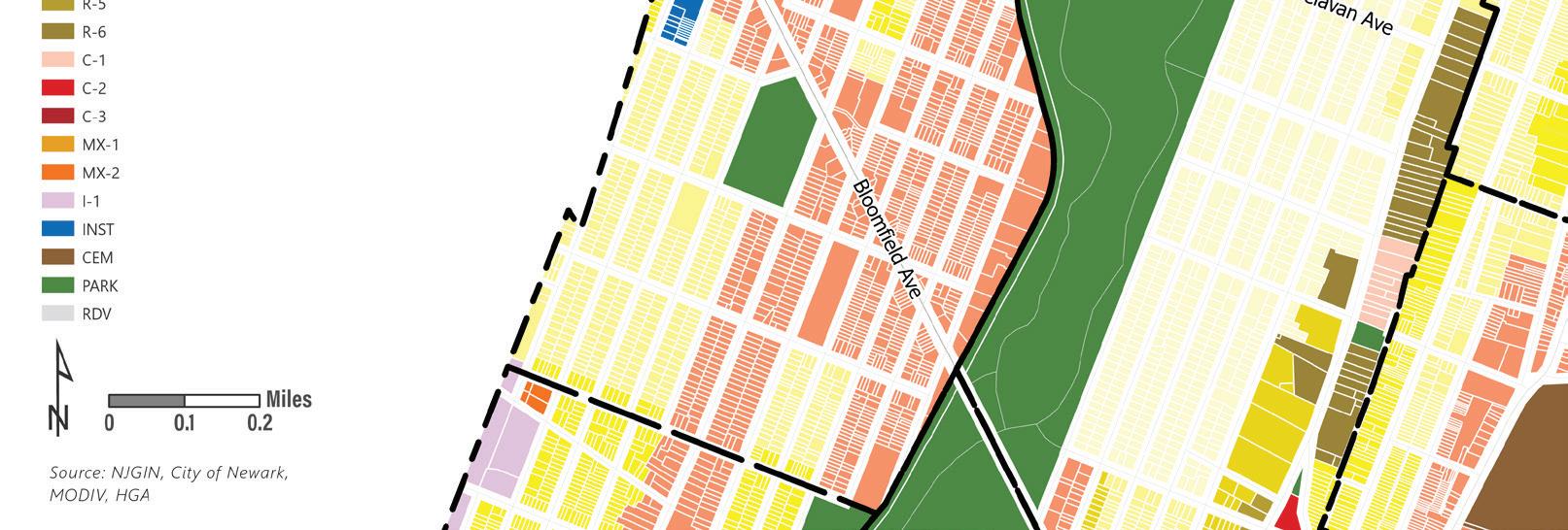
Existing Zoning to Remain
R-1 R-2 R-3 R-4 R-5 R-6 C-1 C-2 C-3 MX-1 MX-2 I-1 INST CEM PARK RDV
Future Land Use
C-2N New C-2 Corridor Zoning
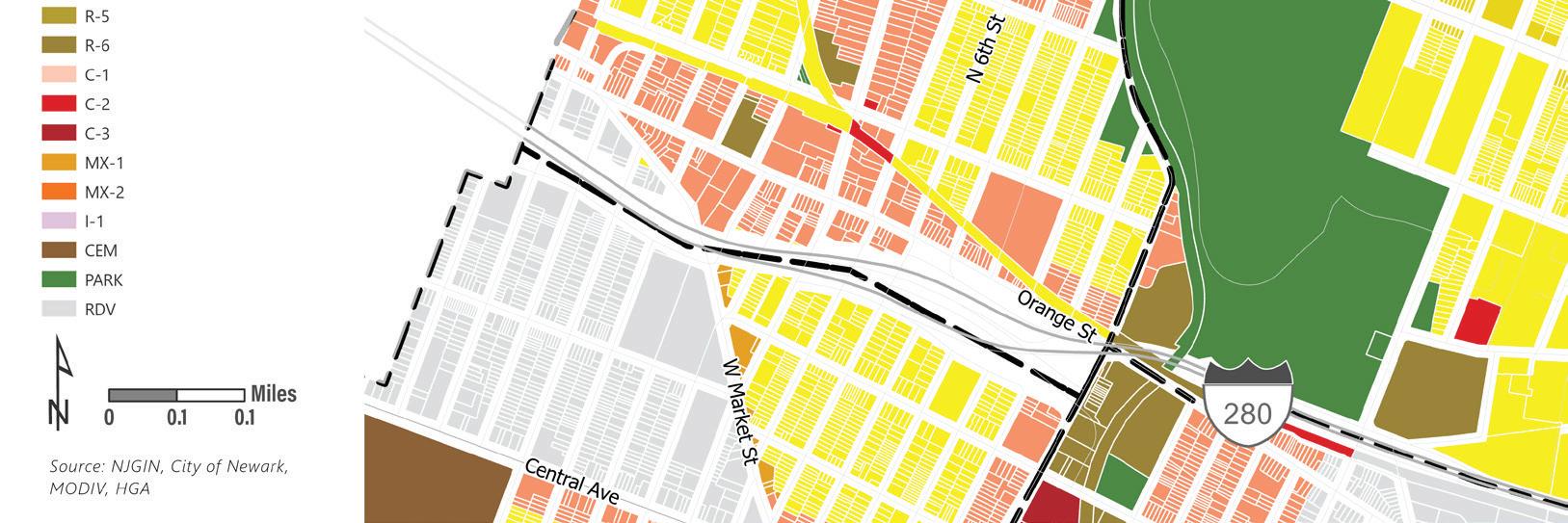
Existing Zoning to Remain
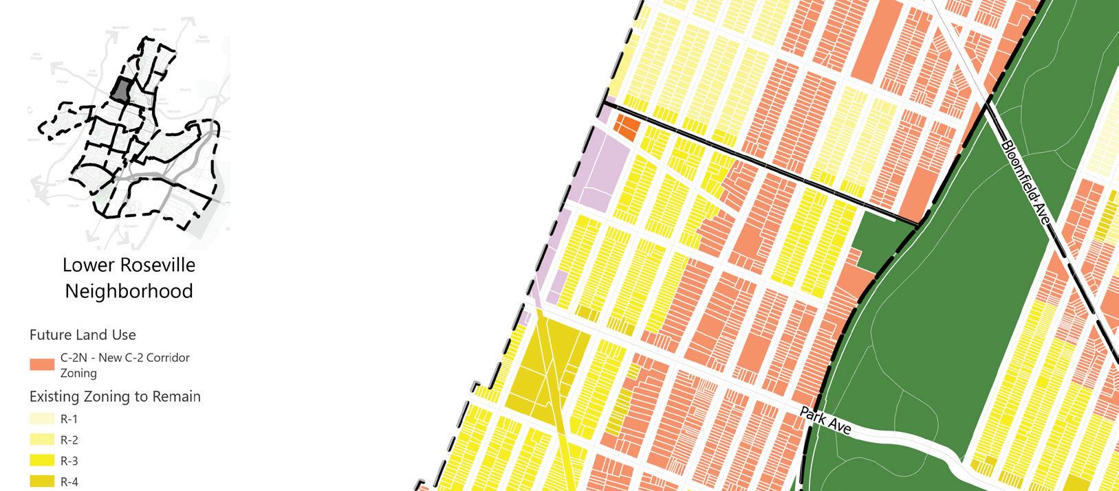
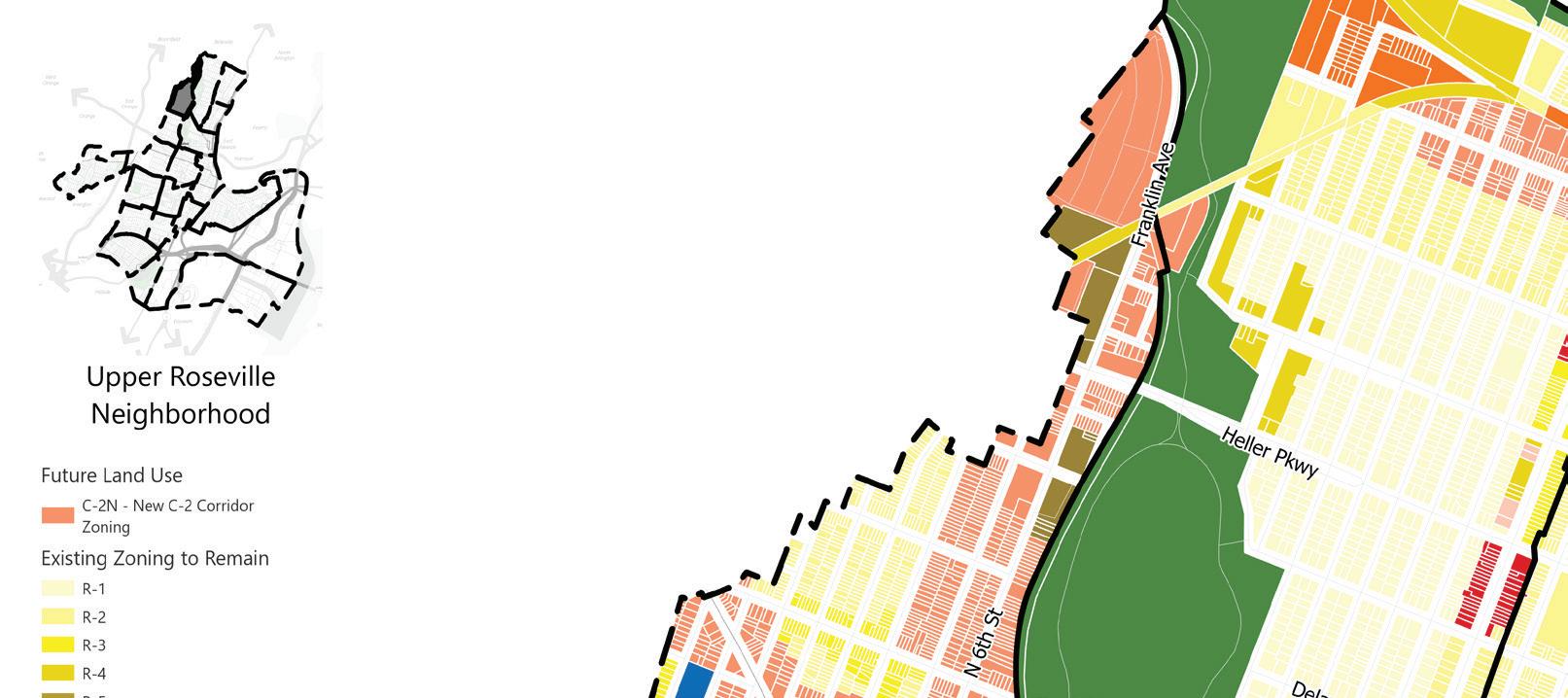
R-1 R-2 R-3 R-4 R-5 R-6 C-1 C-2 C-3 MX-1 MX-2 I-1 CEM PARK RDV
N N 90 | Appendix I.
Future Land Use
C-2N New C-2 Corridor Zoning
Existing Zoning to Remain
R-1
R-2 R-3 R-4 R-5 R-6 C-1 C-2 C-3 MX-1 MX-2 I-1 I-2 INST CEM PARK RDV
N
Future Land Use
C-2N New C-2 Corridor Zoning
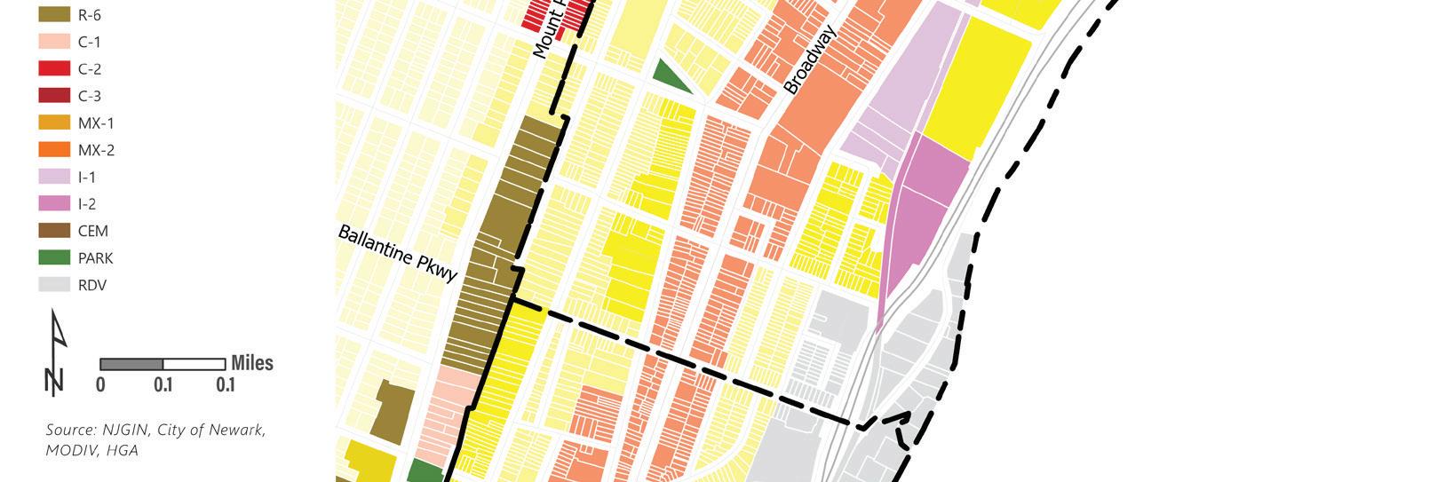

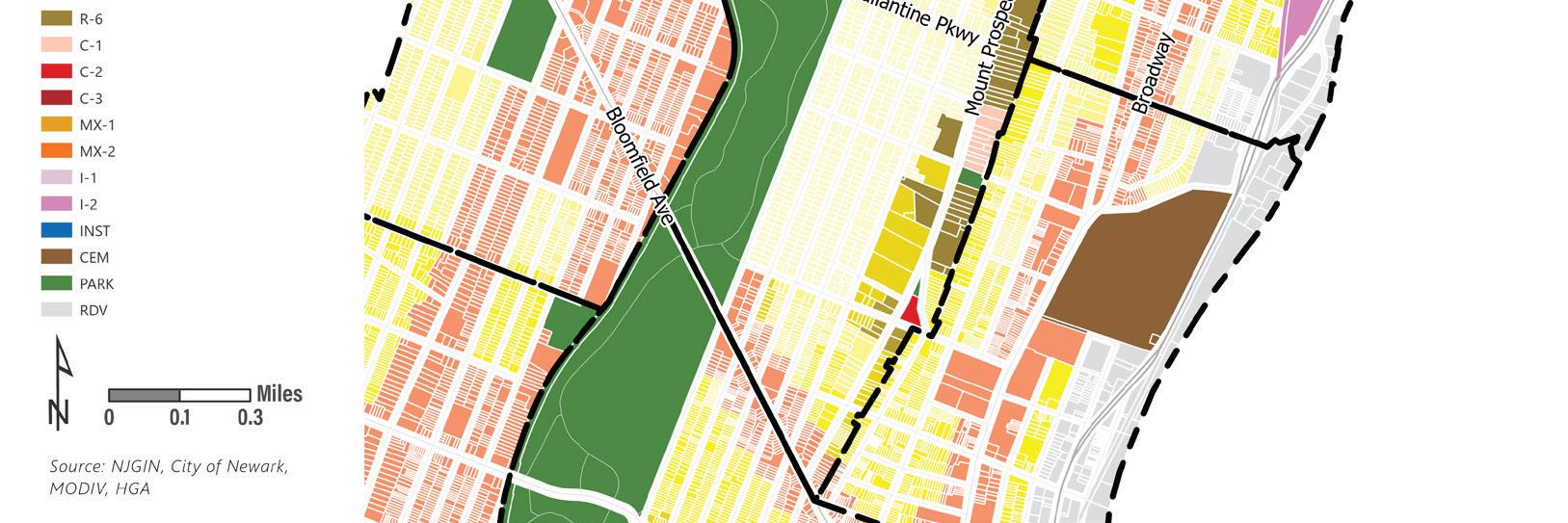
Existing Zoning to Remain
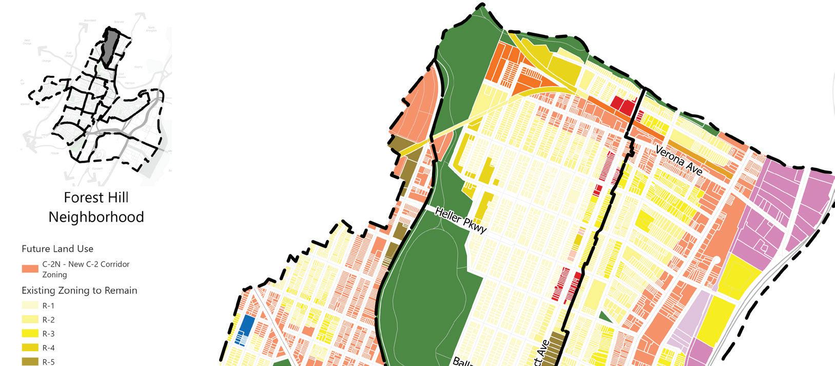
R-1 R-2 R-3 R-4 R-6 C-1 C-2 C-3 MX-1 MX-2 I-1 I-2 CEM PARK RDV
N
Land Use Element | 91
Future Land Use
C-2N New C-2 Corridor Zoning
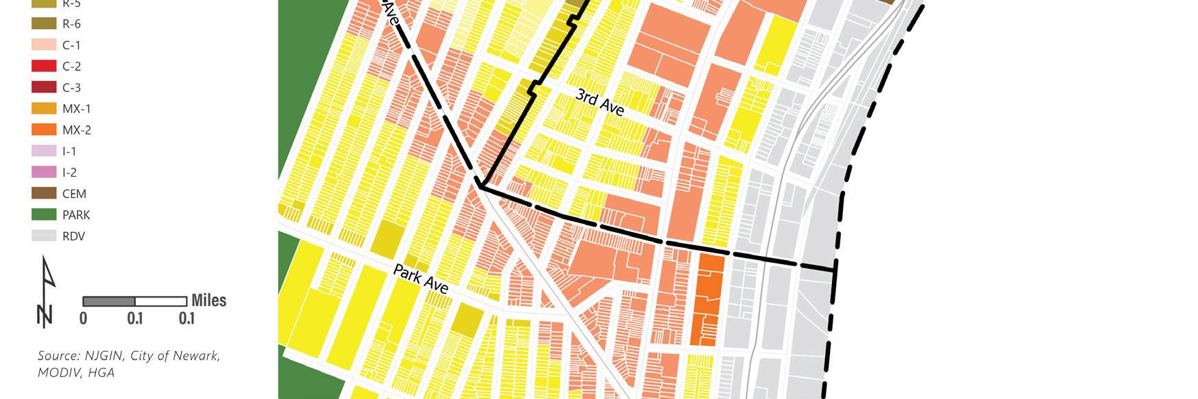
Existing Zoning to Remain
R-1
R-2
R-3 R-4 R-5 R-6 C-1 C-2
C-3 MX-1 MX-2 I-1 CEM PARK RDV
N
Mount Pleasant Neighborhood
Future Land Use
C-2N New C-2 Corridor Zoning
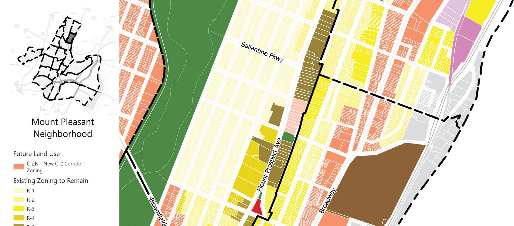
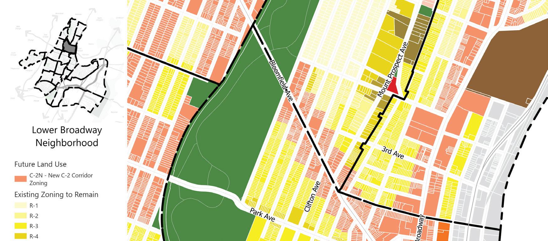
Existing Zoning to Remain
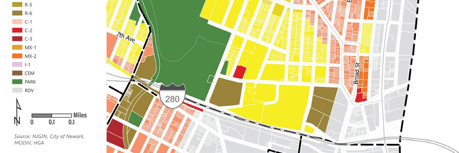
R-1 R-2 R-3 R-4 R-5 R-6 C-1 C-2
C-3 MX-1 MX-2 I-1 I-2 CEM PARK RDV
N
92 | Appendix I.
Future Land Use
C-2N New C-2 Corridor Zoning
Existing Zoning to Remain
R-1
R-2
R-3 R-4 R-6 C-1 C-2 C-3 CEM PARK RDV
Future Land Use
C-2N New C-2 Corridor Zoning
Existing Zoning to Remain
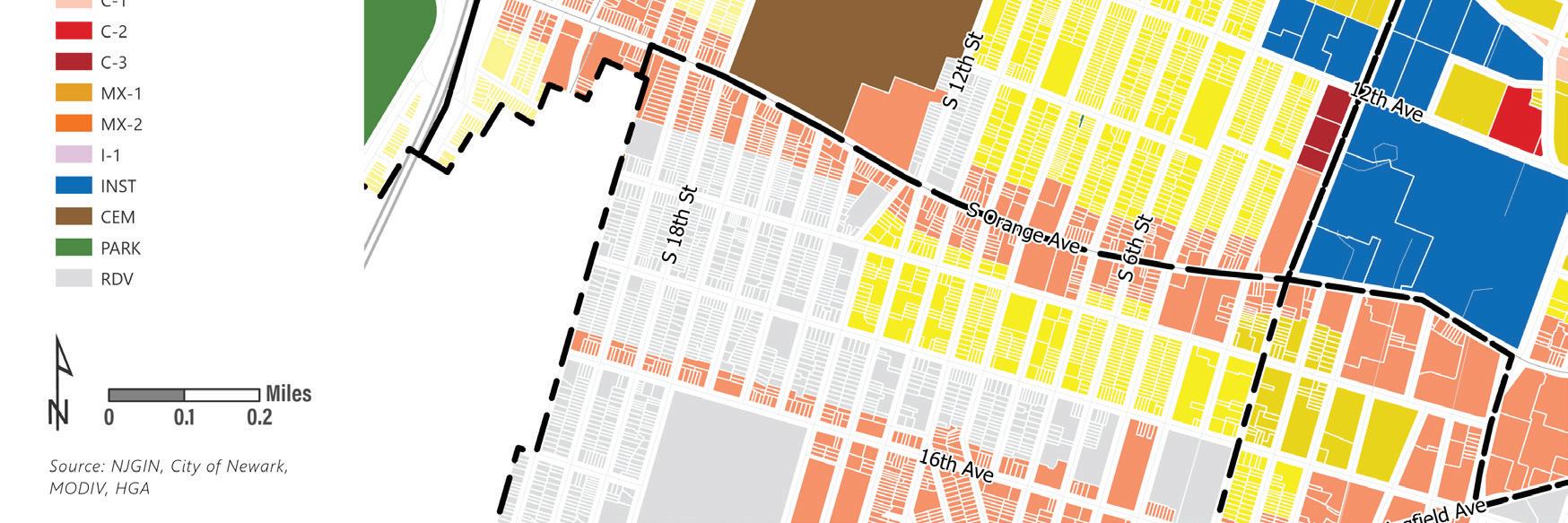
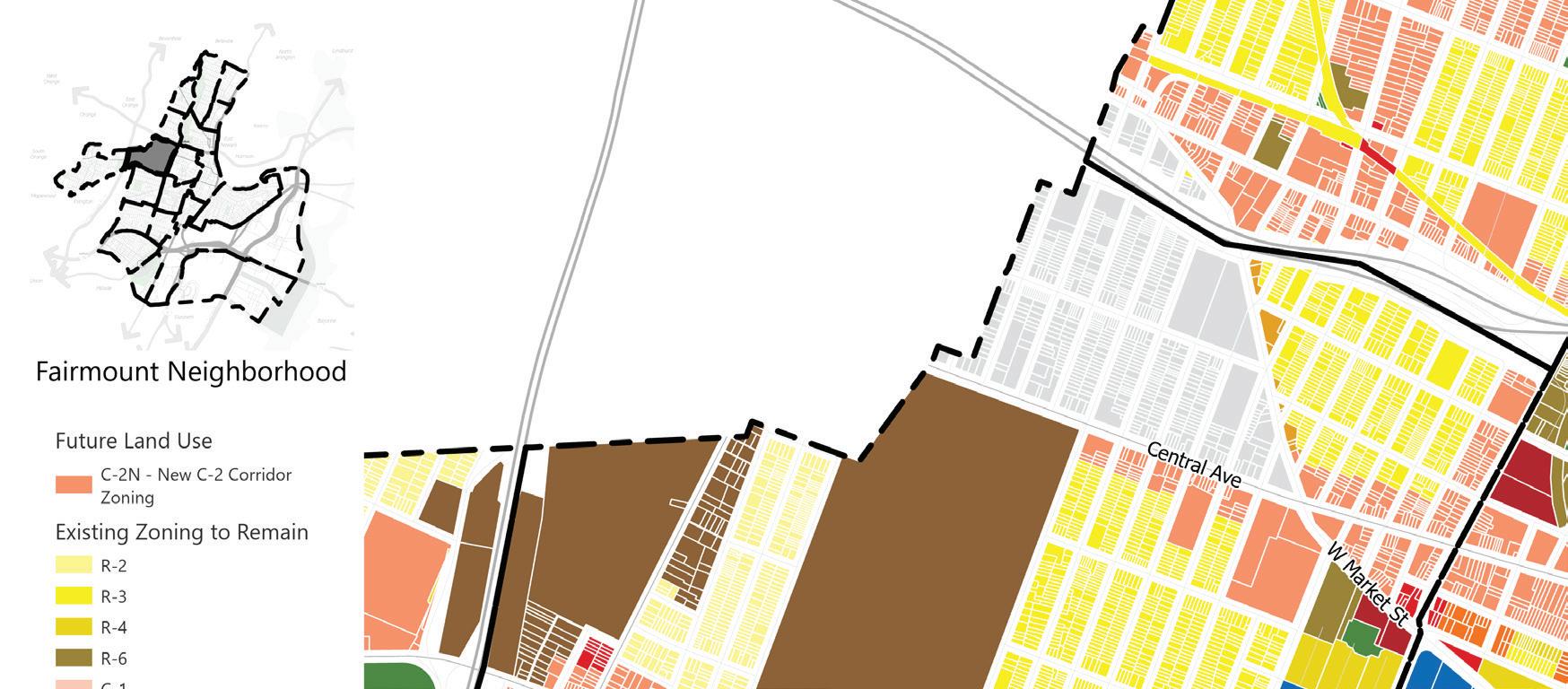
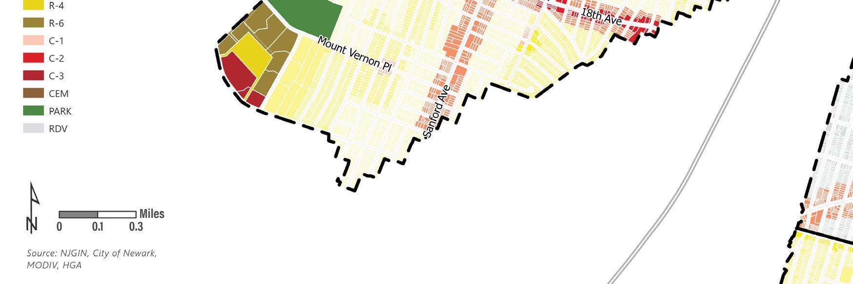
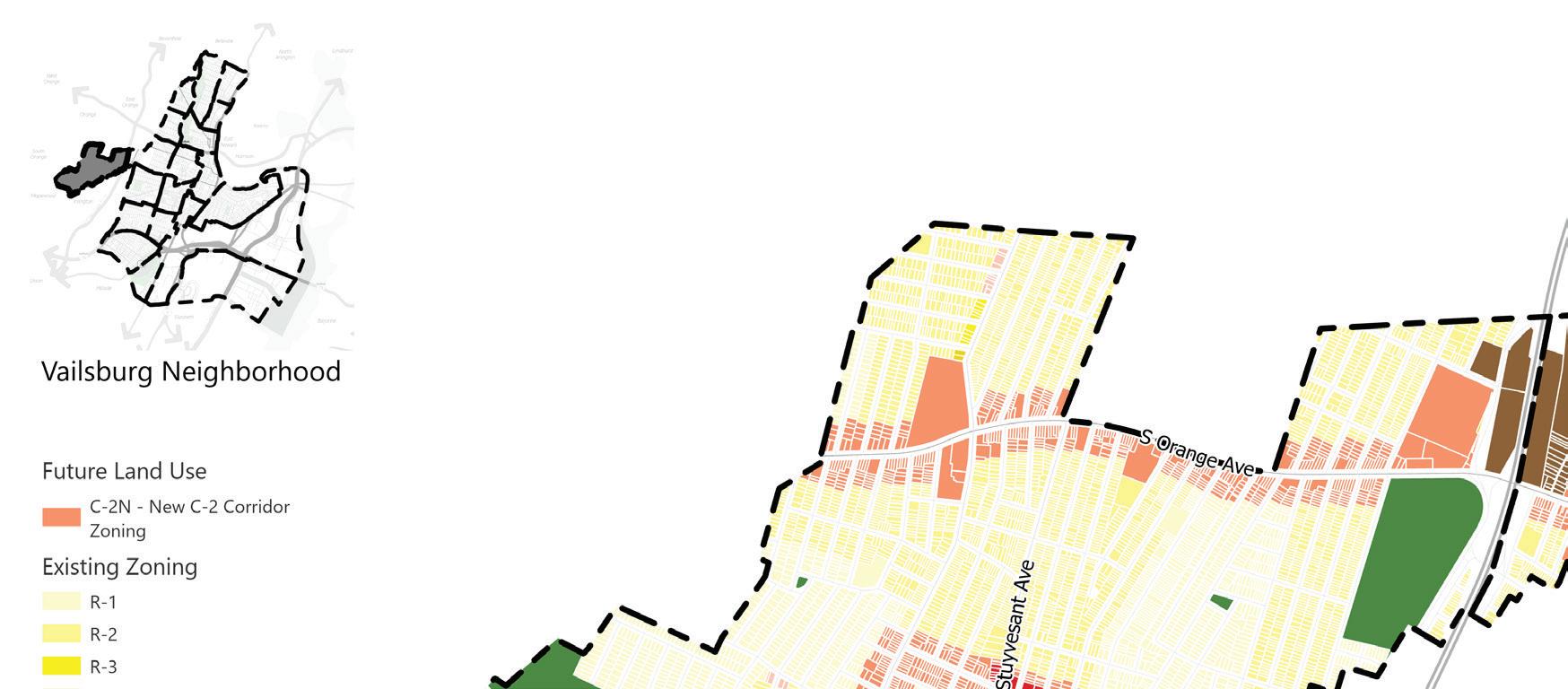
R-2
R-3 R-4 R-6 C-1 C-2 C-3 MX-1 MX-2 I-1 INST CEM PARK RDV
N N Land Use Element | 93
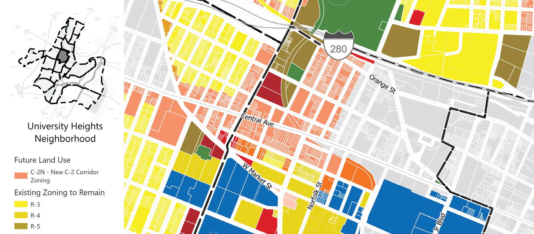
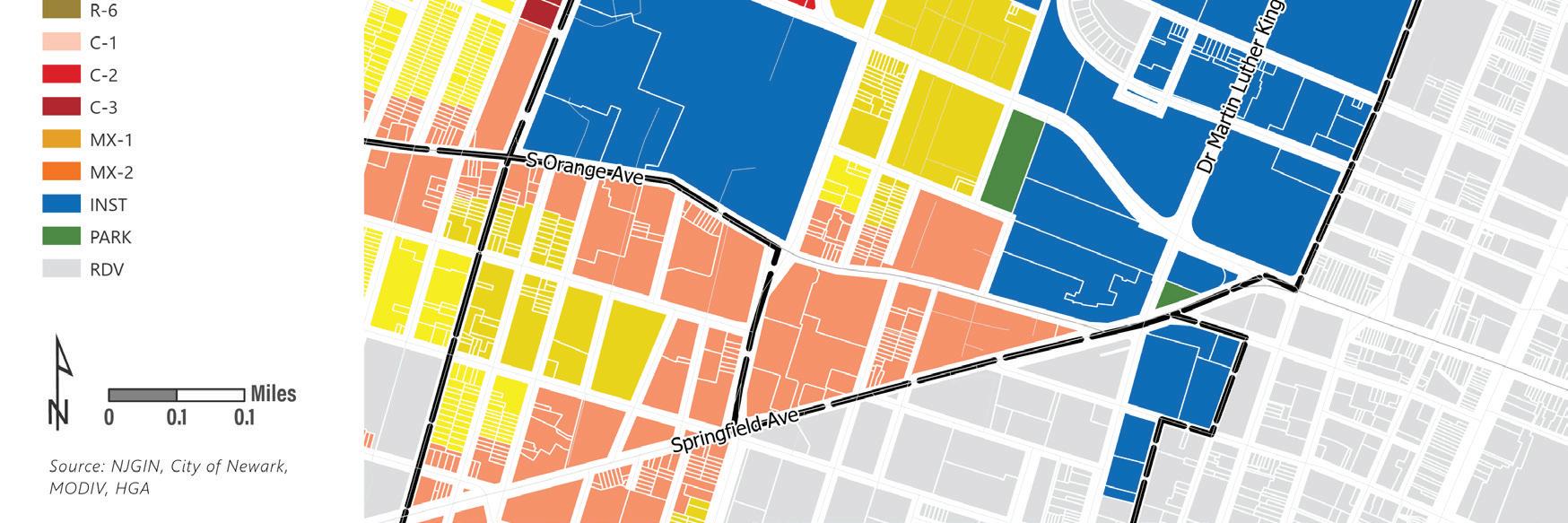
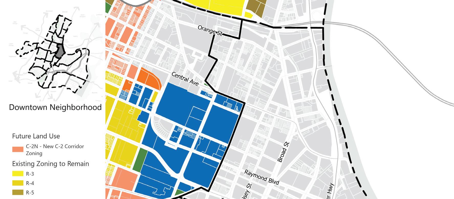
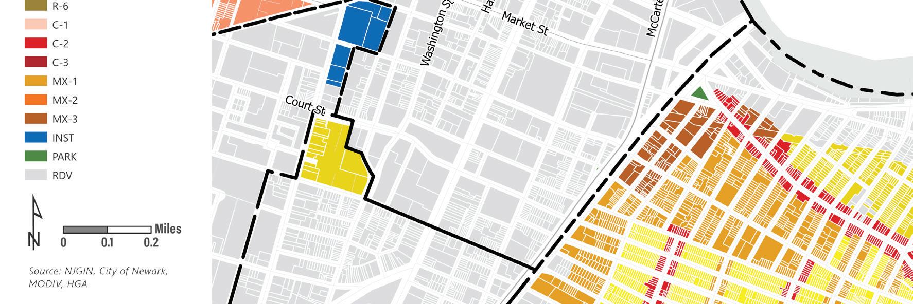
N N 94 | Appendix I.
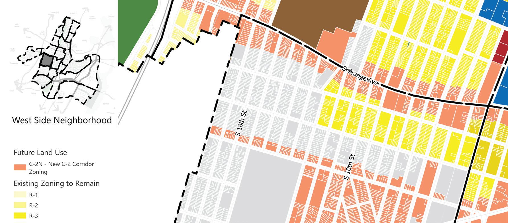
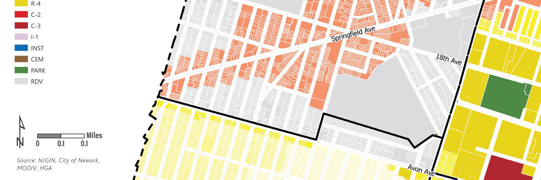
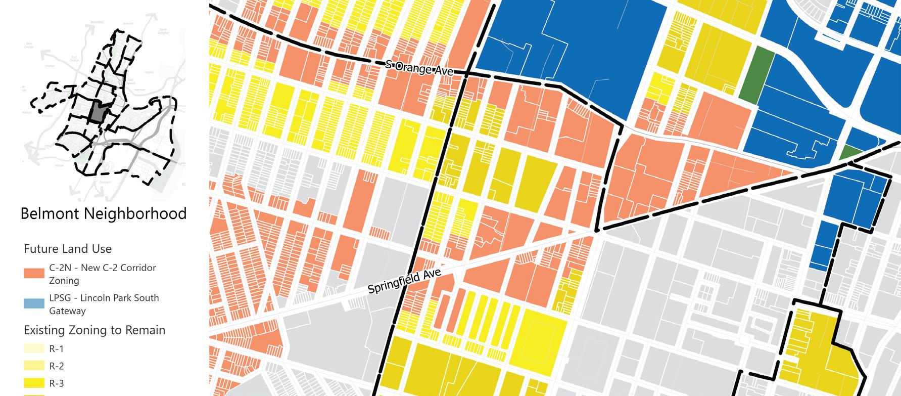
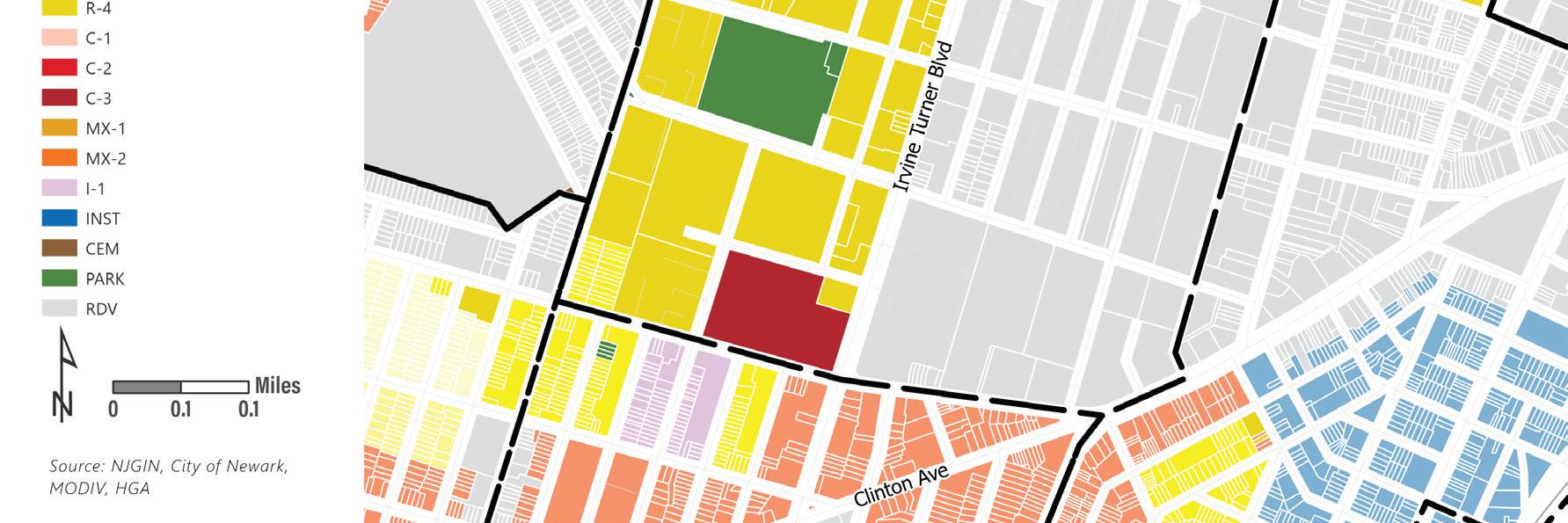
C-2 C-3 PARK RDV C-2N New C-2 Corridor Zoning LPSG - Lincoln Park South Gateway Future Land Use N N Land Use Element | 95
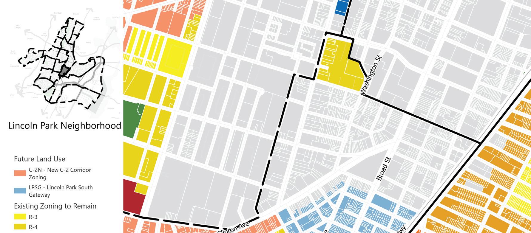
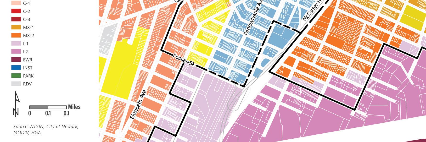
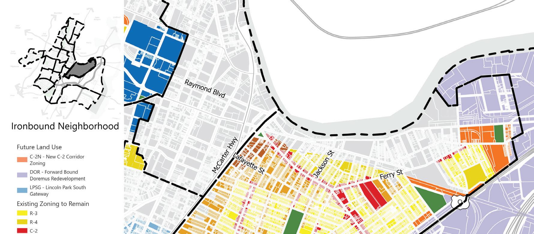
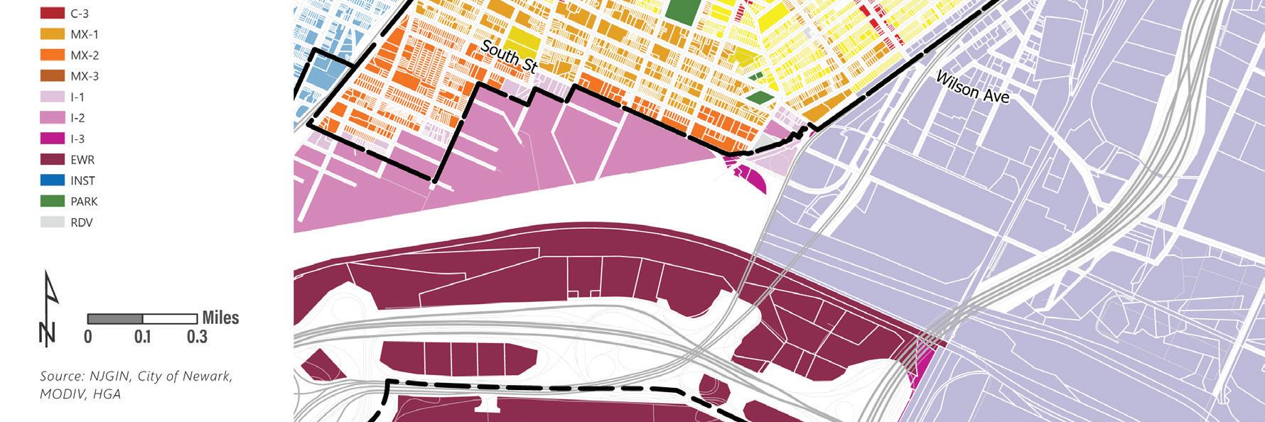
MX-2 Park South MX-2 MX-3 PARK RDV N N 96 | Appendix I.
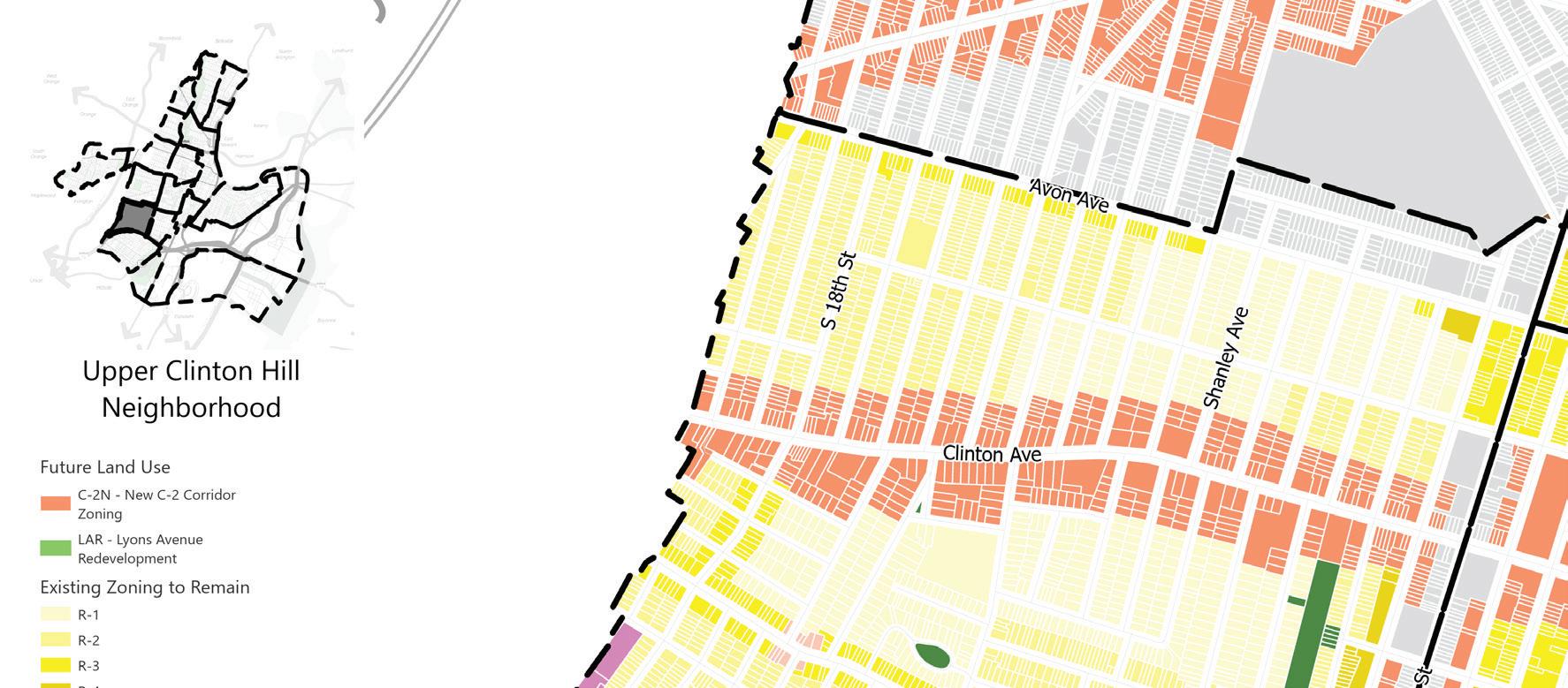
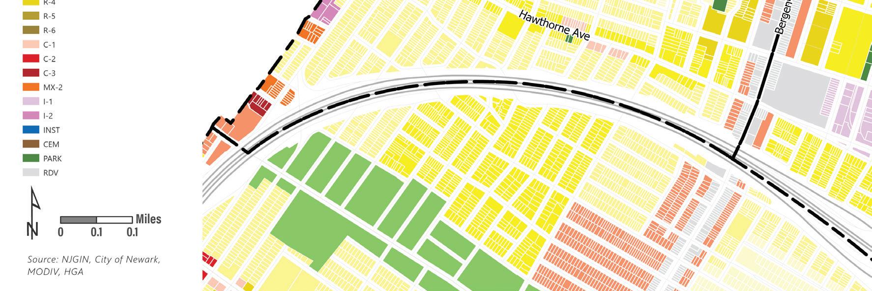
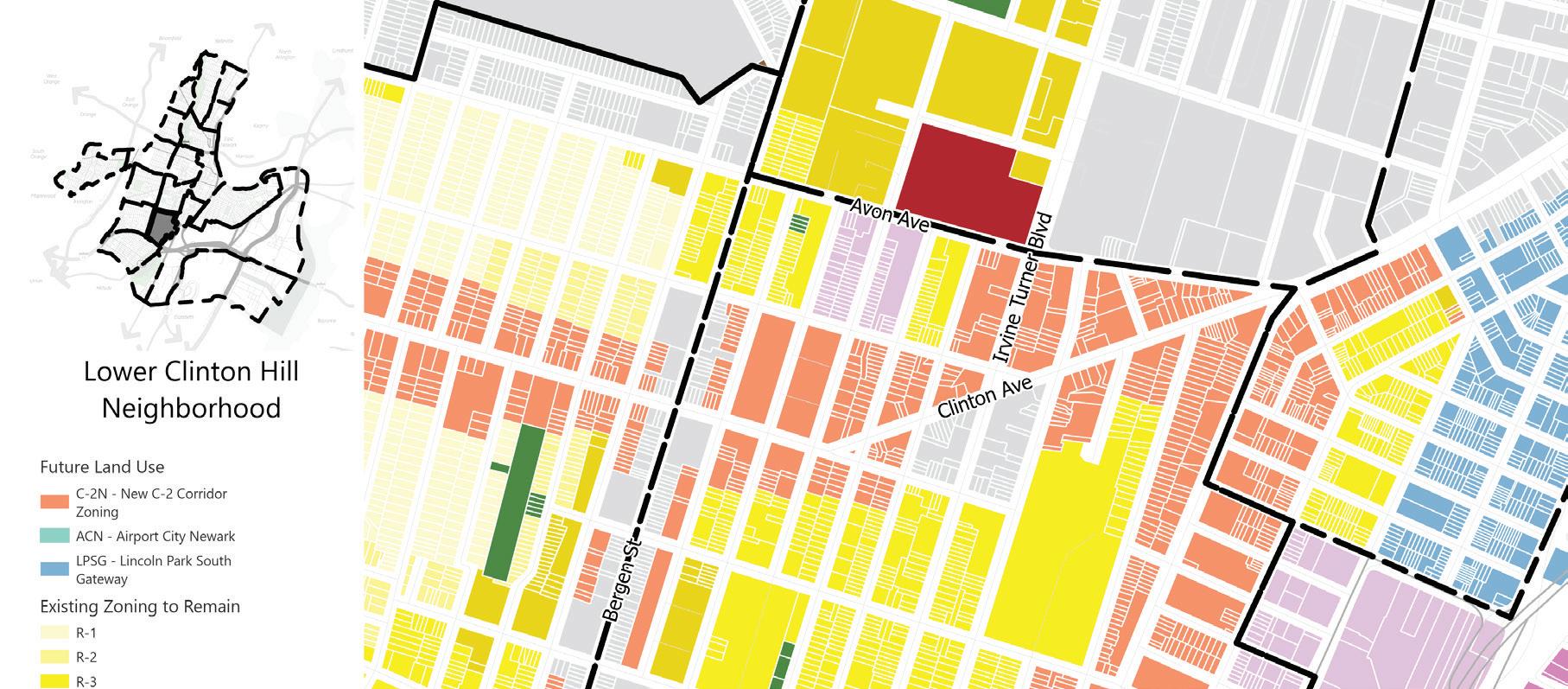
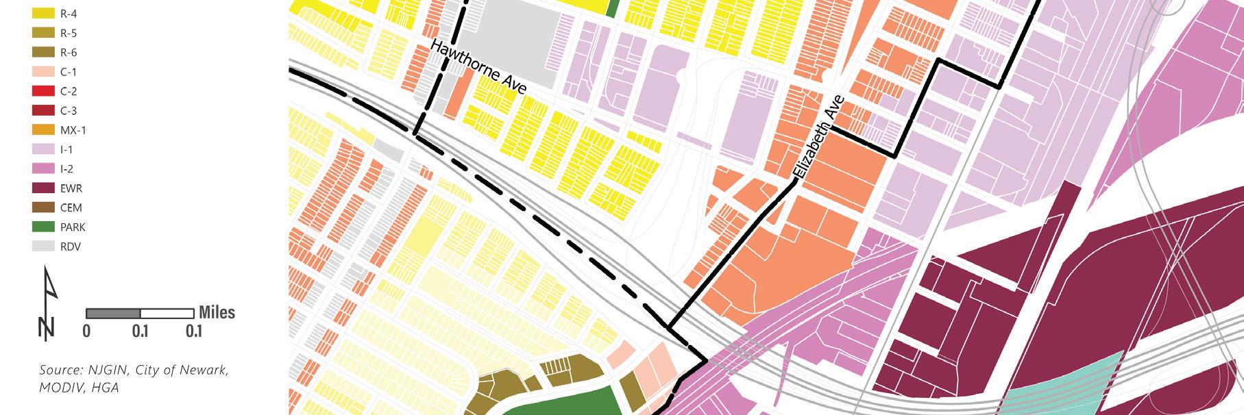
C-2 RDV C-1 C-2 PARK RDV ACN - Airport N N Land Use Element | 97
ACN - Airport
Existing Zoning to Remain
R-1 R-2 R-3 R-4 R-5 R-6 C-1 C-2 C-3
I-1 I-2
EWR INST CEM PARK RDV
ACN - Airport
Existing Zoning to Remain
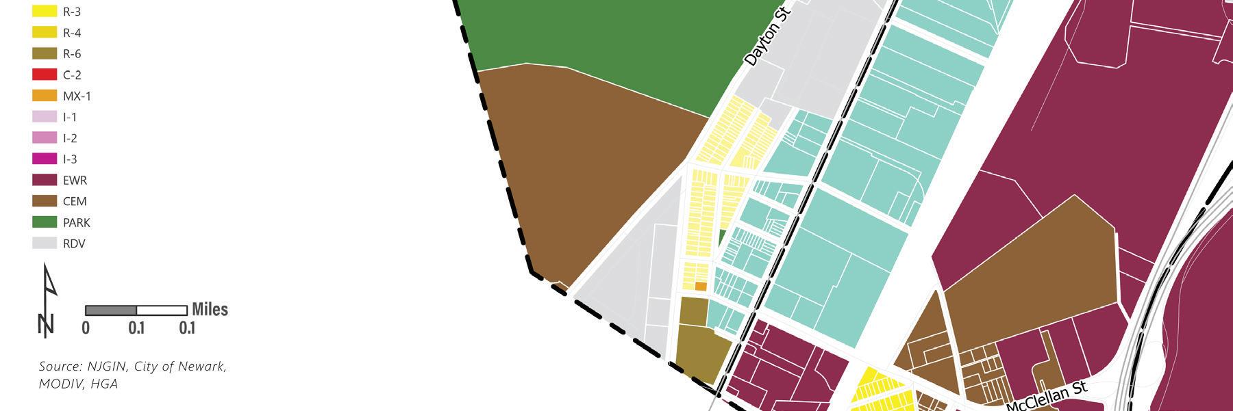
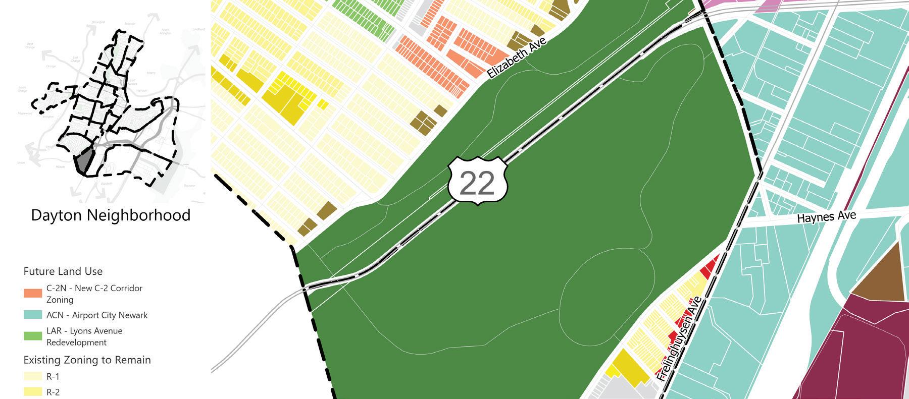
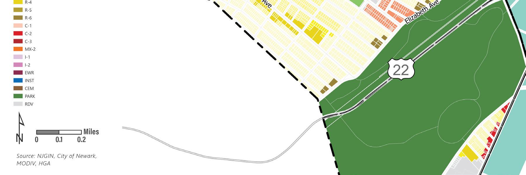
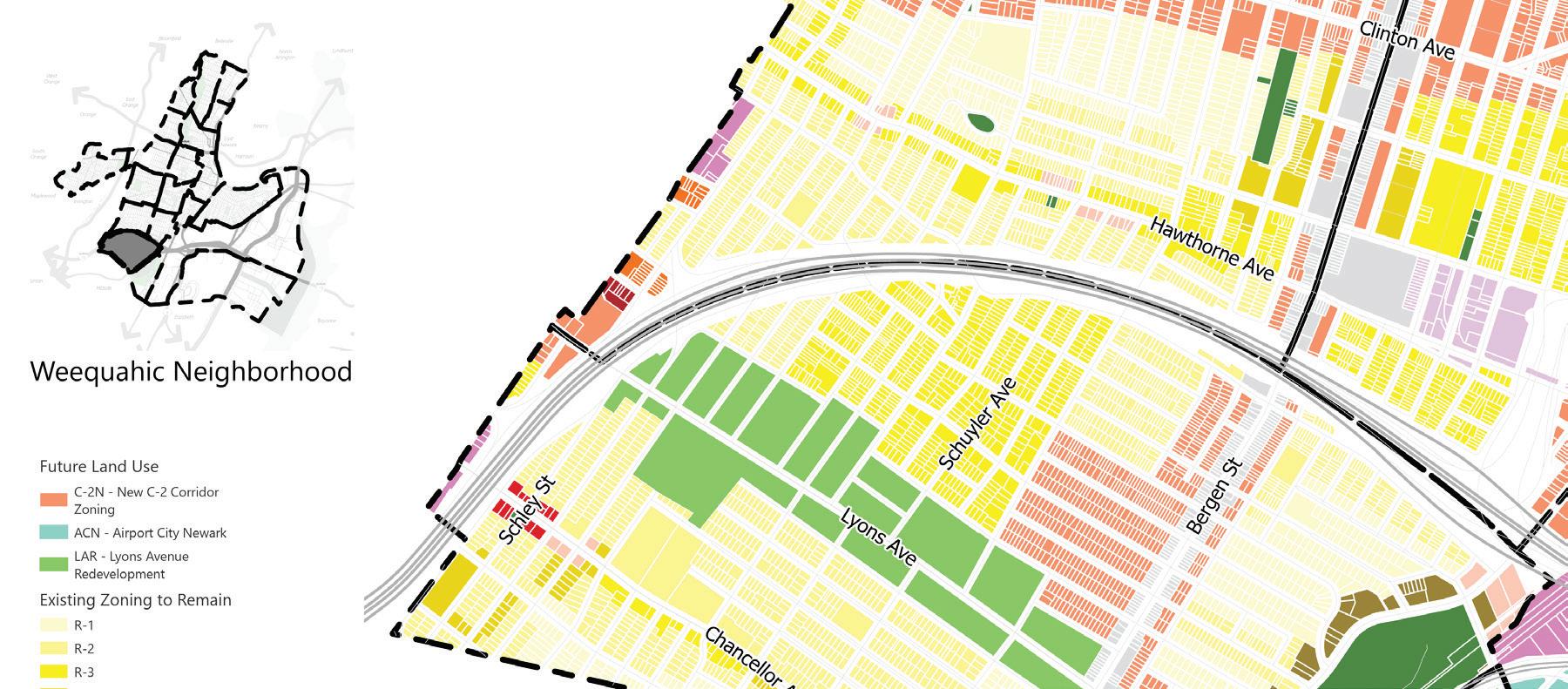
R-1
EWR CEM
R-2 R-3 R-4 R-6 C-2 MX-1 I-1 I-2 I-3
PARK RDV
MX-2
N N 98 | Appendix I.
C-2N New C-2 Corridor Zoning
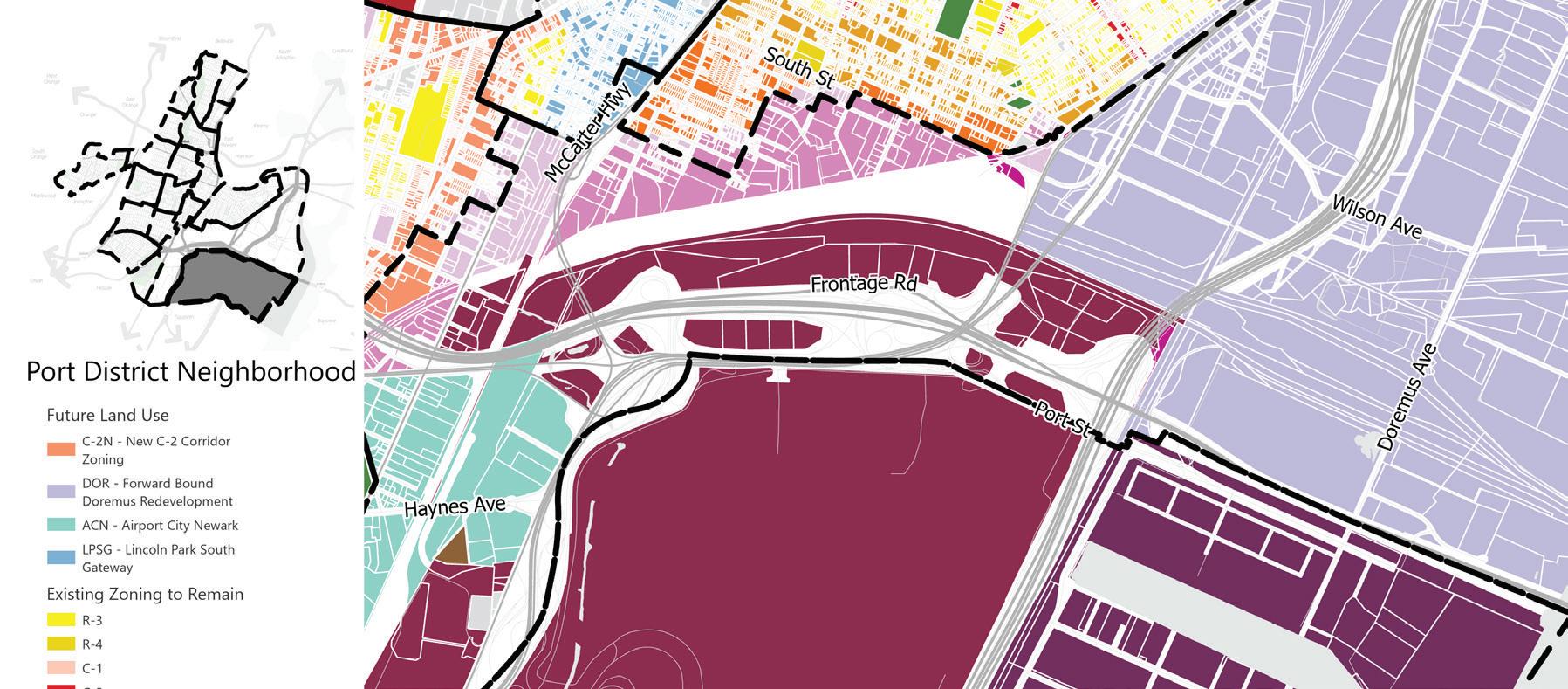
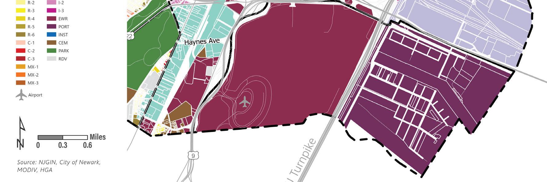
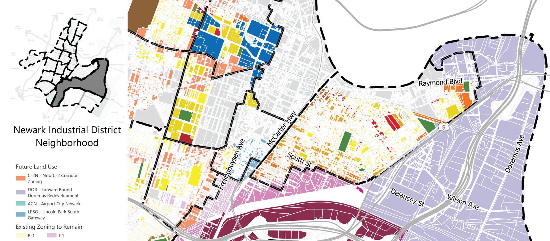
DOR - Forward Bound Doremus Redevelopment
ACN - Airport City Newark
LPSG Lincoln Park South Gateway Future Land Use
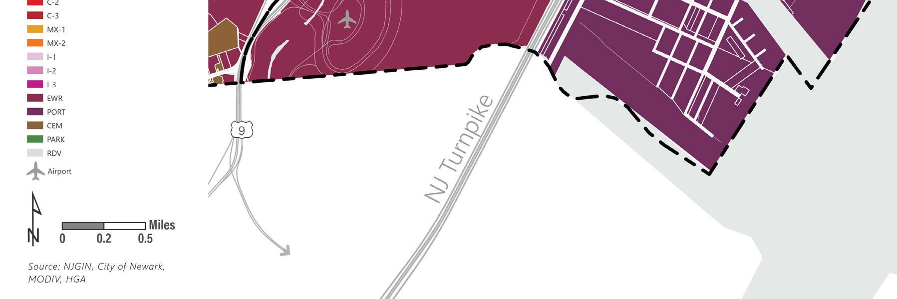
R-6
DOR - Forward LPSG Lincoln Park
C-1 I-1 I-2 PARK RDV
N N Land Use Element | 99
Planning Certification
This Land Use Element was conducted under the direction of John Barree, AICP, Professional Planner in the State of New Jersey.
John Barree, NJPP, AICP
Professional Planner, State of New Jersey
License Number: 33L i 00627000