
San Geronimo protect • connect • restore VISION PLAN A VISION FRAMEWORK JANUARY 2022
Reimagine
with WRT
Environmental Science Associates
Trout Unlimited
VISION PLAN A VISION FRAMEWORK
Notes (Version / Date)
2022
JANUARY
San Geronimo protect • connect • restore
Reimagine
TABLE OF CONTENTS Executive Summary ............................................................................ 8 Project Team ................................................................................................................................................................... 9 Purpose of the Vision Framework ............................................................................................................... 10 Overview of Community Engagement Process 10 Vision Statement ................................................................................. 16 A. Introduction ...................................................................................... 19 About San Geronimo Valley.............................................................................................................................. 21 Social History of the Valley 22 San Geronimo Commons .................................................................................................................................. 26 Lagunitas Creek Watershed 28 B. New Ownership and Vision for the Future ....................... 41 Guiding Principles ................................................................................................................................................... 43 Property Management, Emergency Response, and Community Stewardship 44
5 C. Building a Vision ............................................................................ 47 Summary of Community Feedback........................................................................................................... 48 Site Planning Frameworks 51 Site Opportunity Zones ........................................................................................................................................ 52 Key Site Planning Considerations................................................................................................................ 56 Vision Concepts 62 D. Case Studies ................................................................................... 80 E. References ......................................................................................... 92 F. Appendices ................................................... Separate Document

EXECUTIVE SUMMARY
EXECUTIVE SUMMARY
The Trust for Public Land’s San Geronimo Commons property, nestled in the scenic San Geronimo Valley in west Marin County, spans the valley floor and connects to several public open space preserves. It serves as an informal greenbelt linking the rural communities of Woodacre, Forest Knolls, San Geronimo, and Lagunitas. San Geronimo Creek and Larsen Creek, key tributaries within the Lagunitas Creek Watershed, flow through the property and support one of the largest remaining populations in the state of endangered Central California Coast Coho Salmon and California freshwater shrimp, among other important aquatic species.
The property plays a critical role in ongoing and future restoration efforts for both endangered Coho Salmon and threatened Steelhead Trout populations. As the nexus between four existing public open space preserves – Roy’s Redwoods,
French Ranch, Maurice Thorner, and Gary Giacomini – the San Geronimo property provides rich opportunities for ecological restoration and conservation-compatible recreation, and serves as an invaluable crossroads for both wildlife and recreational trail use. Its proximity to open space areas and local schools and its gentle, walkable terrain allow Marin County residents and visitors of all ages and physical ability to access this beautiful natural setting.
The Trust for Public Land, a national nonprofit conservation organization founded in Marin County in 1972, purchased the 157-acre property in 2018 to protect its as natural open space character, facilitate critical habitat restoration work, connect adjacent open space lands, and create public access opportunities - with a goal of transferring the property to public park ownership. Past uses of the land have degraded many of the
natural features and functions of the property. Meadows that were once a habitat mosaic of oak woodlands, expansive grasslands, and dense riparian forests, were converted to rangeland then golfing uses by previous owners. Natural creeks and drainages that supported salmonids and other species were encroached upon by these uses or forced to flow underground through culverts. The Trust for Public Land envisions a future that facilitates community-based efforts to conserve the San Geronimo Commons, restore its ecological health and resilient functions, support public access including multi-use trails and compatible recreational uses, and make space for a Marin County fire station and community-serving amenities in appropriate locations.
Guided by its commitment to community health and climate resilience, and with this broad vision in mind, The Trust for Public
Executive Summary 8
Land commenced an extensive public engagement process in early 2019 to invite public input into a Vision Framework for the property. Through dozens of large and small engagements, TPL’s goals for this process included building support for conservation and habitat restoration efforts, seeking suggestions for conservation-compatible land uses, creating a re-use framework to guide future owners and managers of the land, and exploring long-term ownership options for the property. Throughout its ownership, The Trust for Public Land has made this privatelyowned land available to the public for passive recreational uses such as walking, hiking, riding and naturewatching, as well as for planning and implementation of habitat restoration projects in partnership with neighbors and other conservation organizations.

PROJECT TEAM
The Trust for Public Land assembled a team of experts in the disciplines of community planning, landscape design, and environmental restoration and design. WRT, LLC an interdisciplinary firm with a national practice rooted in ecological values and community-based planning, led the community engagement process and preparation of a Vision
Framework to guide future use of the property. Trout Unlimited, a national non-profit organization, is The Trust for Public Land’s restoration partner on the San Geronimo project. Trout Unlimited will lead efforts to plan for and implement restoration projects on the property, consistent with its mission to conserve, protect and restore North America’s cold-water fisheries and their watersheds. ESA,
9
Image credit: The Trust for Public Land
an environmental consulting firm, has done extensive work with Trout Unlimited on preliminary restoration design and planning related to this Vision Framework.
PURPOSE OF THE VISION FRAMEWORK
The Vision Framework, also referred to as the Vision in this document, establishes a broad planning foundation to guide future uses of the San Geronimo Commons. The Vision sets forth the primary goals of habitat conservation and restoration, and creates opportunities to plan for and develop compatible public uses. Restoration planning by Trout Unlimited, The Trust for Public Land’s conservation partner, underpins the Vision. Community input and the project team’s technical analysis – to identify which uses best align with The Trust for Public Land’s organizational
mission, values, and real-world constraints - further inform the Vision.
The Vision Framework is meant to direct and guide future land use actions. Conceptual site renderings included in the Vision are not design proposals; rather, they suggest possibilities for how future landowners and land managers may appropriately integrate access, circulation (i.e., trails and pathways), and community activities within the restoration context. Any such future uses would be planned, designed, and managed in conformance with protective covenants that will run with the land. In addition, future uses – a new fire station, for example - may be subject to local and County planning requirements, environmental review, public review and comment, and due diligence efforts. While the site renderings prioritize conservation goals and illustrate restoration potential, they
also examine opportunities for creating memorable experiences and deeper connections with nature by identifying compatible movement patterns and community uses Each of the property’s three large parcels -the two meadow parcels and the clubhouse parcelpresent distinctive attributes that offer unique restoration and public access opportunities.
OVERVIEW OF THE COMMUNITY ENGAGEMENT PROCESS
In the spring of 2019, The Trust for Public Land convened a yearlong, facilitated community engagement process that invited the public to help reimagine the future of the 157-acre San Geronimo Commons property within the broad context of ecological restoration. From the outset, TPL envisioned creating a new community asset: a restored and resilient natural
Executive Summary 10
11
Stakeholder
Workshops,
Community Engagement Internal Analysis & Draft Vision Framework
September 2020
January
September
FALL 2020
FIGURE 1: PROCESS DIAGRAM
One on One Stakeholder Meetings
Group Site Tours
Open Houses, Site Tours Project Website Stakeholder Engagement
June 2019
October 2019
2019 August 2019
2019
landscape that would contribute to the ecological health and functions of the Valley, including fire and climate resilience, and provide open space accessible to all. To achieve these goals, TPL invited robust public input with the following overarching objectives:
• Share The Trust for Public Land’s conservation and public access goals for the San Geronimo property,
• Provide science-based information and guidance regarding existing conditions and habitats, and the many restoration opportunities that exist for the property and surrounding areas,
• Engage in meaningful dialogue with the community regarding potential conservation-compatible future uses and outcomes for the property, and
• Develop a Vision Framework for the property that highlights conservation, restoration, and public access opportunities; incorporates and reflects public input in a meaningful way; and is valued by and beneficial to a broad cross section of the community.
The community engagement process focused on sharing information about the land and its sensitive ecology while exploring compatible community and public uses. This approach was reflected in the range of engagement activities listed below:
• Reimagine San Geronimo Website/ Email
• One-on-One and Small Group Stakeholder Meetings with The Trust for Public Land staff and project team
• Focus Group Meetings
• Stakeholder Group Site Tours (3)
• Community Open House
• Visioning Workshop
• Periodic Newsletters from The Trust for Public Land
• Ongoing Community Conversations with The Trust for Public Land
Three overarching planning objectives informed the community engagement process: Protect, Connect, and Restore are central themes that meet The Trust for Public Land’s organizational values and mission, and reflect important community goals shared in the preliminary stakeholder conversations. The project team considered all community recommendations regarding future uses in the context of their consistency with these three thematic and organizing goals.
Executive Summary 12
Community Outreach Events


13
As specific categories of use emerged during the community engagement process, the team developed Site Planning Frameworks to organize these ideas and guide development of the Vision Framework.
1. Restoration and Ecological Management: Prioritizing restoration activities that enhance the property’s ecological health and functions, support the region’s biodiversity and climate resilience, and maximize opportunities to support broad efforts to restore the Bay Area’s last great Choho Salmon run in the greater Lagunitas Creek watershed.
2. Recreation: Continuing to provide and expand upon conservationcompatible recreational opportunities on the property, while supporting the health of its ecological resources.
3. Access & Connectivity: Ensuring safe recreational access for all and improved connectivity to adjacent public lands through a regional trail network.
4. Community: Supporting opportunities to create a social and community hub and related amenities in appropriate locations on the property, with a focus on public uses within and around the existing Clubhouse.
5. Fire Safety: Supporting fire-safety for the Valley by making space for a new Marin County fire station and ensuring that property uses are consistent with fire resilience and best practices for fire safety management.
6. Partnerships and Funding: Creating a vision that is financially feasible, creates opportunities for strategic partnerships, and advances
conservation, land stewardship, and public access objectives.
In developing the Vision Framework, the team applied the Site Planning Frameworks to the entirety of the community feedback to identify desired uses for the property that align with The Trust for Public Land’s conservation and public access goals. The Vision distills this extensive feedback in the context of The Trust for Public Land’s mission, guiding principles, and practical considerations. These are foundational to the Vision Framework.
Executive Summary 14
Community Outreach Events


15
VISION STATEMENT
Section Title 16
The San Geronimo Commons will be protected in perpetuity as conserved land and public open space. Any future uses of the property should prioritize habitat restoration and ecological health, create meaningful connections for wildlife and people, integrate compatible passive recreational activities, and provide opportunities to engage with and interpret nature.
The property will be a place for Marin County residents and visitors to come together in community, and to act as natural stewards of the land.
A. INTRODUCTION

A. Introduction Non-Profit Owned Preserve City Park Urban Special District Preserve NICASIO NORTH NOVATO BOLINAS INVERNESS EAST SHORE KENTFIELD SOUTH NOVATO MARINWOOD STRAWBERRY SLEEPY HOLLOW GREEN POINT POINT REYES STATION TAMALPAIS INDIAN VALLEY MARIN CITY WALDO POINT WOODACRE ALMONTE HOMESTEAD BLACK POINT MUIR BEACH SAN QUENTIN STINSON BEACH LAGUNITAS FOREST KNOLLS OLEMA COUNTRY CLUB LOS RANCHITOS LUCAS VALLEY LOMA VERDE SAN GERONIMO MUIR WOODS PARK PARADISE CAY BAYSIDE ACRES POINT SAN PEDRO SUN VALLEY 1 1 1 37 NOVATO SAN RAFAEL TIBURON MILL VALLEY LARKSPUR FAIRFAX CORTE MADERA ROSS SAUSALITO BELVEDERE SAN ANSELMO 101 101 PT REYES NATIONAL SEASHORE GOLDEN GATE NATIONAL RECREATION AREA Nicasio Resevoir Kent Lake PACIFIC OCEAN TomalesBay Alpine Lake Bon Tempe Lake Stafford Lake Soulajule Resevoir MT. WITTENBERG Samuel P Taylor State Park Tomales Bay State Park Stafford Lake County Park
LOCATION
FIGURE 2:
MAP
A. INTRODUCTION
ABOUT SAN GERONIMO VALLEY
San Geronimo Valley, located in the heart of Marin County, lies on both sides of Sir Francis Drake Boulevard and extends from the town of Fairfax to West Marin. The Valley is part of Marin County’s “Inland Rural Corridor” and, as the name suggests, it has a predominantly rural character. The Valley is a special place by virtue of the rich natural resources it enjoys. The redwood-, fir- and oak-studded hillsides of the area offer scenic views
and protect the watershed’s health. A key functional and aesthetic feature of the Valley is San Geronimo Creek, which is part of the larger Lagunitas Creek Watershed. It is one of the last places along the central California coast to support a Coho Salmon population and one of the few places where people and salmon exist so closely together. In addition, the Valley enjoys significant conservation areas such as Roy’s Redwoods Preserve, French Ranch Preserve, Maurice Thorner Memorial Preserve, and Gary Giacomini Preserve.
21
SOCIAL HISTORY OF THE VALLEY
The first people to discover the beauty and bounty of the San Geronimo Valley were Marin County’s original inhabitants, the Coast Miwok. From archeological evidence, we know they established seasonal camps thousands of years ago along what is now San Geronimo Creek, taking advantage of its robust runs of salmon, as well as the elk and deer herds that populated the hillsides, and the rich acorn harvest provided by the Valley’s many tanoaks and coast live oaks, which they tended assiduously. Sah-ta-ko means “People of the Tanoak” in Coast Miwok and is a name the inhabitants of this area gave themselves.
There is no word for “war” in the Coast Miwok language, and the people suffered tremendously following the settlement of San Francisco’s Mission Dolores in 1776. In 1770, there were between 1,500-2000 Coast Miwok
living in their traditional territory of Marin and southern Sonoma; by 1880, only 60 remained. The last historic band of Coast Miwok - the Huimen Band – disappeared from the County by 1805. Their knowledge and stewardship of the land were replaced in the 1830s by Euro-American settlers who moved into the Valley to extract the abundant natural resources that had sustained the Coast Miwok for millennia. Valley industries throughout the 19th century included ranching, timber and logging camps, paper mills, powder mills, and fur trapping. Samuel P. Taylor’s mill, and other paper mills, dotted Lagunitas Creek downstream of the Valley.
The first instance of land ownership in the form of title-holding occurred in the Valley in 1844, when the Mexican government granted 8,800 acres called Rancho Cañada de San Geronimo (Valley of St. Jerome) to Rafael Cacho, a military officer and friend of General Mariano Vallejo. Rafael lived on the rancho with his
family, grazing cattle and horses, for two decades. In 1864, he sold the property to Lieutenant Joseph Warren Revere, grandson of Paul Revere and American naval officer who had also served in the Mexican army under General Vallejo.
Early Coast Miwok lived in small hunter gatherer bands, with a diet that included salmon, acorns, nuts and deer. Original stewards of the land, the Coast Miwok managed its ecology and natural resources, and likely used controlled burning to increase forage for game, stimulate seed production, and regenerate the soil. For example, they managed vegetation cover using fire to encourage oak trees to grow and to create open space for deer and other desirable plants and animals (Joe Sanchez, documented MLD (most likely descendent) Coast Miwok by the Bureau of Indian Affairs, and member of the Coast Miwok Tribal Council of Marin County). The last historic band of Coast Miwok - the Huimen Band –disappeared from the County by 1805.
A. Introduction 22
The Cañada [hollow or vale] of San Geronimo is one of the loveliest valleys in California, shut in by lofty hills, the sides of which are covered with redwood forests, and pines of several kinds, and interspersed with many flowering trees and shrubs peculiar to the Country. Through it flows a copious stream, fed by the mountain brooks; and the soil in the bottomlands is so prolific, that a hundred bushels of wheat to the acre can be raised with the rudest cultivation and other crops in corresponding abundance.

23
“ “
- Joseph Revere (circa 1846)
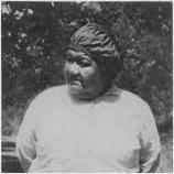
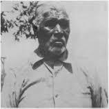
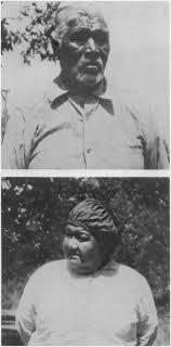
Local Coast Miwok elders, Tom Smith and Maria Copa. Local “last known descendants” of the Coast Miwok tribe trace their lineage back through one of these two individuals.
Adolph Mailliard - purportedly the grandson of Joseph Bonaparte, King of Spain and Naples, and brother of Napoleon Bonaparte – purchased the land for $50,000. Adolph constructed an 18room family home near Castle Rock in Woodacre
Title to the Rancho Cañada de San Geronimo property changed hands once again in 1868, when Adolph Mailliard - purportedly the grandson of Joseph Bonaparte, King of Spain and Naples, and brother of Napoleon Bonaparte – purchased the land for $50,000. Adolph constructed an 18room family home near Castle Rock in Woodacre, and in 1877, transferred title to approximately 450 acres (including present-day Roy’s Redwoods) to James and Thomas Roy in San Geronimo, who planted large fields of wheat in the rich meadowlands once stewarded by the Coast Miwok.
In the early 1900s, Adolph Mailliard’s heirs began subdividing the Rancho Cañada de San Geronimo property, and ultimately sold their remaining interest to the Lagunitas Development Company in 1912. The land was further subdivided to create the communities of Forest Knolls, San Geronimo, and Woodacre. In the early part of the
century, homes in the Valley were used primarily as summer cabins, and the population never exceeded 4,000. The opening of the Golden Gate Bridge in 1937, and post-World War II growth, however, brought the potential for dramatic development.
In April 1961, the Marin County Board of Supervisors adopted a Master Plan proposal for the Valley that envisioned 20,000 new residents and substantial development. The Master Plan included amenities that would support – and be supported by – this influx, including 5,000 new multi-family residences, a Civic Center, shopping center, golf course, and a freeway crossing through present-day Roy’s Redwoods into Nicasio Valley. The 18-hole San Geronimo Golf Course was constructed on what is now the San Geronimo Commons in 1965, and a subdivision of 18 homes was built adjacent to the course. No other elements of the 1961 Master Plan were
developed, and in 1973 – following extensive community involvement and advocacy - the Master Plan was rescinded and replaced by a Countywide Plan that incorporated environmental protection measures and significantly reduced the potential for development in the Valley.
Today the population of the San Geronimo Valley (including Woodacre, San Geronimo, Forest Knolls, and Lagunitas) is about 3,200. Throughout its history, despite many changes in land use, industry, and demography, the Valley’s rural character has remained and is widely cherished by today’s local communities.
A. Introduction 24

25 Historical Timeline
SAN GERONIMO COMMONS
The 157-acre San Geronimo Commons property -also referred to as Sah-tako Commons to acknowledge Marin County’s original inhabitants, the Coast Miwok -is situated in the heart of the San Geronimo Valley and framed by rolling hillsides – a location that provides both functional and aesthetic benefits.
The San Geronimo Commons stretches across the valley and is bisected east to west by Sir Francis Drake Boulevard, an important twolane arterial road that connects San Rafael to State Route 1 and serves as the gateway to West Marin. Nicasio Valley Road, San Geronimo Valley Drive, and Lagunitas School Road also border the property. Point Reyes Station is approximately twelve miles to the northwest of the property. San Rafael is eight miles to the southeast,
and about eighteen miles further south is the city of San Francisco.
The property serves as a geographic hub and critical wildlife corridor linking over 100,000 acres of largely contiguous public open space from the Golden Gate National Recreation Area to the Point Reyes National Seashore. It is surrounded by Marin County open space preserves as well as large swaths of state and national park lands. Single-family residential homes dot the landscape immediately adjacent to the property and surrounding open space areas. Miles of regional hiking and biking trails begin at the property’s boundary, and an existing network of older paved paths on the property currently accommodate walking, jogging, bicycling, safe routes to school, nature viewing, and quiet contemplation.
A small pedestrian tunnel under Sir Francis Drake Boulevard, several bridges, a 15,000-square-foot
clubhouse building, and a 200-car parking lot are also present on the property, and support access and circulation for passive recreational opportunities such as hiking, bicycling, and horseback riding.
The San Geronimo Commons property includes three large parcels –
• The Larsen Meadow parcel north of Sir Francis Drake Blvd and west of Nicasio Valley Road,
• The Clubhouse parcel northeast of the intersection of Sir Francis Drake Boulevard and Nicasio Valley Road, and
• The San Geronimo Meadow parcel bordered by San Geronimo Valley Drive south of Sir Francis Drake Blvd
A. Introduction 26
27 Non-Profit Owned Preserve City Park Urban Special District Preserve NICASIO NORTH NOVATO BOLINAS INVERNESS EAST SHORE KENTFIELD SOUTH NOVATO MARINWOOD STRAWBERRY SLEEPY HOLLOW GREEN POINT POINT REYES STATION TAMALPAIS INDIAN VALLEY MARIN CITY WALDO POINT WOODACRE ALMONTE HOMESTEAD BLACK POINT MUIR BEACH SAN QUENTIN STINSON BEACH LAGUNITAS FOREST KNOLLS OLEMA COUNTRY CLUB LOS RANCHITOS LUCAS VALLEY LOMA VERDE SAN GERONIMO MUIR WOODS PARK PARADISE CAY BAYSIDE ACRES POINT SAN PEDRO SUN VALLEY 1 1 1 37 NOVATO SAN RAFAEL TIBURON MILL VALLEY LARKSPUR FAIRFAX CORTE MADERA ROSS SAUSALITO BELVEDERE SAN ANSELMO 101 101 PT REYES NATIONAL SEASHORE GOLDEN GATE NATIONAL RECREATION AREA Nicasio Resevoir Kent Lake PACIFIC OCEAN TomalesBay Alpine Lake Bon Tempe Lake Stafford Lake Soulajule Resevoir Samuel P Taylor State Park Tomales Bay State Park Stafford Lake County Park
OPEN SPACE
FIGURE 3: REGIONAL
AND TRAILS
LAGUNITAS CREEK WATERSHED
The San Geronimo Commons is situated along San Geronimo and Larsen Creeks in the upper reaches of the Lagunitas Creek watershed, a precious natural asset in the heart of rural west Marin County. Draining the largest watershed in Marin County, Lagunitas Creek flows approximately 22 miles from its headwaters on Mount Tamalpais to its mouth at the southern end of Tomales Bay. San Geronimo Creek is the last undammed tributary of Lagunitas Creek, and while it accounts for less than one tenth of the total watershed, its lack of dams and relatively natural hydrograph have consistently sustained almost half of the recorded Coho Salmon spawning sites in the watershed. However, while it remains a crucial resource, the main stem of San Geronimo Creek has been degraded over time by excessive runoff, channel incision and erosion,
and is now much more confined and disconnected from its floodplain and riparian corridor compared to historic conditions, as discussed below. San Geronimo Creek supports a mature but narrow riparian corridor characterized by a mix of Coast Live Oak, Valley Oak, Alder, Willow and Cottonwood trees. Sections of riffle pool channel and gravel bed channel are maintained by shallow bedrock as well as woody debris accumulations.
Larsen Creek, a smaller, ephemeral tributary to San Geronimo Creek, also provides habitat for different life stages of salmon and steelhead populations, and makes important contributions to riparian ecosystem functions to the watershed. Two named forks of Larsen Creek flow through the Commons: the main channel and the North Fork of Larsen Creek.
Before entering the San Geronimo property, the main channel of Larsen Creek flows through Roy’s Redwoods
Preserve where it has been impacted by informal trails and compaction of the forest floor in the park’s old-growth redwood grove. Larson Creek’s main stem is characterized by two distinct reaches, upstream and downstream of a large bedrock outcrop in the channel that forms a natural barrier to upstream migration by salmon and steelhead. The downstream reach, the majority of which flows through the San Geronimo property, is a small, highly confined gravel bed channel experiencing similar erosional processes and floodplain disconnection as San Geronimo Creek. The creek currently enters the property under Nicasio Valley Road at the property’s northeast corner, where approximately 1,500 feet of the creek has been buried underground in culverts and routed through two constructed ponds on the San Geronimo property. Similarly, several seasonal drainages to Larsen
A. Introduction 28
29 N 2000 ft 0 ft 5000 ft SAN GERONIMO VISION PLAN REGIONAL MAP Site Area Water Body Primary Watershed Boundary Secondary Watershed Boundary Secondary Watershed Boundary Stream Wildlife Corridor Federal Preserve County Park State Park Non-Profit Owned Preserve City Park Urban Special District Preserve Trail Network Cycling Route Major Road BLACK MOUNTAIN MT. WITTENBERG PINE MOUNTAIN LOMA ALTA Nicasio Resevoir Kent Lake PACIFIC OCEAN TomalesBay Alpine Lake Bon Tempe Lake Stafford Lake NICASIO POINT REYES STATION FIVE BROOKS OLEMA INVERNESS PARK SAN GERONIMO WOODACRE FAIRFAX SLEEPY HOLLOW LUCAS VALLEY MARINWOOD IGNACIO TERRA LINDA SAN ANSELMO SAN RAFAEL NOVATO FOREST KNOLLS LAGUNITAS TOCALOMA LAGUNITAS CREEK WATERSHED SAN GERONIMO CREEK WATERSHED 1 1 101 101
FIGURE 4: LAGUNITAS CREEK WATERSHED
Creek have been routed through culverts to support past land uses.
The North Fork (NF) of Larsen Creek is a small channel within a mature and relatively intact riparian corridor. NF Larsen Creek is formed by two headwater tributary streams that are characterized by steep, well defined channels that extend upslope on the surrounding hills, delivering stormwater flows to the creek in winter, and providing terrestrial wildlife habitat and cover year-round.
Ecological Setting
The Lagunitas Creek watershed, which includes San Geronimo Creek, has statewide significance as a home for protected aquatic species, including Coho Salmon, Steelhead Trout, and California freshwater shrimp. The Lagunitas Creek watershed supports the most viable wild population of endangered Central California Coast Coho Salmon, making up nearly 10%
of the state’s Coho Salmon population. The watershed also supports one of the largest remaining populations of endangered California freshwater shrimp in the State, making it an important stronghold for the species.
Other special status species that occur in the Lagunitas Creek watershed include Northern spotted owl, California red-legged frog, foothill yellow-legged frog, and tidewater goby. Notable native species that occur in the watershed include river otter, Pacific giant salamander, the California and rough-skinned newts, and northwestern pond turtles (California Species of Special Concern). Because of this diverse community of sensitive species and critical habitats, the Lagunitas Creek watershed has long been viewed as an important priority location for conservation efforts and species recovery.
The San Geronimo Commons property historically supported a broad,
complex riparian corridor, including connected floodplain areas set within native grasslands and surrounded by oak woodlands and redwood forests. These native grasslands, oak woodlands, and redwood forests were largely converted to rangeland, and subsequently, to a 19-hole golf course. Modifications to the property to accommodate these uses included removal of many small streams that once drained the adjacent hillslopes and flowed through the landscape as well as the creation of artificial topographic features. These changes degraded and fragmented the habitats, and compromise landscape connectivity and wildlife movement across the Valley and between existing open spaces. Although the property has been altered over timein ways that have impacted the type, quality, and extents of habitat areas – the property continues to provide important, albeit limited, breeding,
A. Introduction 30

31
FIGURE 5: LAGUNITAS CREEK WATERSHED DETAILS
overwintering and migratory habitat for a range of aquatic and wildlife species and, most importantly, now presents unique opportunities and a vital resource for species recovery and climate resilience.
Salmon and Steelhead in San Geronimo Commons

Coho Salmon and Steelhead Trout belong to the fish family commonly referred to salmonids. Salmonids have a very unique and sensitive lifecycle. The lifecycle begins with adult salmonids laying eggs in the gravel beds of creeks. Their juvenile offspring spend their early life in those creeks for a period of months to years until they grow large enough to migrate out to the ocean. Once in the ocean, they mature for several years, and eventually return to their natal creeks (where they were born) to lay their eggs as adults, restarting the entire cycle. Each stage of this
complex lifecycle requires the right watershed conditions: the absence of barriers for fish migrating upstream; clean gravel and cold water for egg incubation; cool, deep, well-shaded pools to shelter juveniles during the summer; floodplains, off-channel alcoves and fallen trees to shelter juveniles from fast flowing winter floods; and a healthy riparian corridor to provide shade, cover, and an ongoing source of river wood and food. Despite making up only 10% of the total watershed, San Geronimo Creek supports 40% of the Lagunitas Creek Coho Salmon spawning, and over 30% of the watershed’s juvenile rearing habitat. The San Geronimo Commons property annually supports active spawning sites for Coho and steelhead, and observations of redds (or egg nests) documented by the Marin County Municipal Water District specifically show a high density found on the property extending from Roy’s

A. Introduction 32
Coho salmon in Lagunitas Creek
Steelhead trout in Lagunitas Creek
Pools upstream to the confluence with Woodacre Creek.
Salmonids enter the Lagunitas Creek watershed from Tomales Bay and make their way up to the San Geronimo Valley in the late fall and winter after storm events. Main stem San Geronimo Creek is one of the primary spawning areas for salmon and steelhead. Spawning also commonly occurs in lower Larsen Creek although juvenile fish move into San Geronimo Creek as seasonal flows recede. Juvenile Coho stay in the Lagunitas Creek watershed for approximately one year after emerging. Steelhead may remain for one to four years in their natal stream, while Chinook (limited observations and documentation) only remain for a few months. Depending on habitat conditions, some juvenile salmonids remain near where they hatched, while others migrate further upstream, or move downstream to Lagunitas
Creek in search of quality habitat conditions. San Geronimo Creek currently provides some of the most persistent summer rearing habitat for juvenile fish, as other tributaries in the Valley typically dry out. Salmon population numbers in San Geronimo Valley are highly variable in any given year, but long-term population trends make it clear that statewide Coho salmon populations, and the population in San Geronimo Valley, are in crisis. Preserving and restoring Coho and other species populations depends on creating self-sustaining watershed conditions to support their varying lifecycle needs. The Commons property has great potential to provide for those needs through an intentional program of preservation, enhancement, restoration and expansion of habitat conditions and ecosystem functions.
The Need and Opportunity for Restoration and Ecological Management
Though still one of the most favorable locations for salmonid spawning and rearing on the entire Central California Coast, San Geronimo Creek has been impacted by human development in the watershed. The creek once supported a broad riparian forest with a well-connected floodplain surrounded by grass and forested uplands. However, increased stormwater runoff due to historic logging, land clearance, culverting of tributary streams and drainages, and urban development has caused San Geronimo Creek to erode down into its bed over many decades, becoming entrenched and disconnected from its historic floodplain in the process. This has had several impacts on watershed health. Winter flows that would have spread out across alluvial fans (sediment
33
accumulations) or spilled out onto the floodplain and created wetter habitat are now rapidly connected through ditches and culverts and concentrated in the channel. These changes dry the floodplains out, reduce groundwater infiltration, funnel more water more rapidly downstream, and degrade riparian habitat. The confined channel is faster-flowing and more erosion-prone than it was prior to development, scouring away the gravels in which salmon and steelhead lay their eggs, as well as eroding the creek banks causing a loss of trees and valuable shade. The flashier and more intense flows flush out juvenile salmonids and/or force them to expend valuable energy fighting stronger currents. These conditions are present in San Geronimo Creek throughout the property, threatening current and future habitat quality for salmonids and other aquatic species and limiting the extent and health of adjacent riparian habitat.
However, the San Geronimo Commons property offers unique and important restoration opportunities along significant lengths of these two streams – San Geronimo Creek and Larsen Creek - with the potential to create more complex and expansive riparian floodplain habitat that provides high-quality spawning, rearing, and refuge habitat for fish; valuable breeding and stopover habitat for birds; and improved winter groundwater recharge, summer streamflow, and water quality throughout the year. These opportunities will build off recent and planned actions to remove fish migration barriers (Roy’s Pools and San Geronimo Valley Drive) and expand floodplains, and they include the potential to restore additional reaches for salmonid spawning and rearing. The restoration of connected and complex floodplains on Larsen Creek and San Geronimo Creek will create broad and sustainable riparian corridors around the creeks that support many species of fish, birds,
and animals, and function as wildlife corridors between adjacent open spaces. On Larsen Creek there are opportunities to restore headwater hydrologic processes that improve groundwater recharge and reduce fine sediment, as well as to daylight and restore the culverted portions of the creek and its tributaries within the San Geronimo Commons. These efforts could contribute importantly to habitat and water quality improvements on both the property and downstream reaches of San Geronimo Creek.
There are also opportunities to manage and/or enhance the constructed ponds located on the San Geronimo Commons. Several ponds provide aquatic and wetland habitat for a diversity of wildlife, as well as scenic and recreational values, but they currently harbor predators such as largemouth bass and American bullfrog that prey on native fish and frogs.
A. Introduction 34
Former fish Ladder at San Geronimo Creek prior to restoration aided adult salmon, but created poor habitat conditions for young coho salmon and steelhead trout and limited juvenile fish migration downstream.

35
Land Use and Planning Context
A majority of the land within the ~6,000-acre San Geronimo Valley is privately owned, with singlefamily residential uses representing approximately 30% of total land ownership, followed by agricultural ownership at nearly 10% and institutional ownership (including the San Geronimo Commons) reflecting another 10%. The Marin County Open Space District is the largest public landowner, owning and managing about 37% of the watershed as public open space lands, reflecting local commitment to preserving the rural character of the area.
The San Geronimo property is under the jurisdiction of Marin County and is zoned Resort and Commercial Recreation District (RCR). The Marin Countywide Plan land use designation is Recreational Commercial (RC).
The current use of the property as open space complies with County zoning ordinances and plans, and is
consistent with the San Geronimo Valley Community Plan, adopted as part of the Marin Countywide Plan.
The Resort and Commercial Recreation zoning district is intended to create and protect resort facilities in pleasing and harmonious surroundings, with emphasis on public access to recreational areas within and adjacent to developed areas. Permitted uses in the RCR zone include visitor-serving commercial uses, such as lodges, bars, and restaurants. Conditional uses allowed with a permit include community centers, outdoor commercial recreation, and playgrounds.
In addition to the Marin Countywide Plan, the Marin County Zoning Code and the San Geronimo Valley Community Plan apply to the San Geronimo Valley community. The San Geronimo Valley Community Plan, which was adopted as part of the Marin Countywide Plan, presents goals, objectives, policies, and programs that aredesigned to
preserve the unique natural attributes of the Valley and its communities as well as the historical character of the built environment. The Plan provides direction to property owners, community groups, and interested individuals in formulating and reviewing new developments.
This Vision Framework is not a Master Plan or set of design proposals. Rather, it is a guide for future land owners and managers that sets forth conservation priorities for the property and outlines conservation-and wildlife-compatible recreational and community land use opportunities.
Implementation and activation of many future uses discussed in the Vision Framework may be subject to local and Marin County planning requirements, environmental review, public review and comment, and/or due diligence activities such as soils testing and engineering assessments.
A. Introduction 36
37 N 200 ft 0 ft 500 ft Water Body Site Boundary Path Regional Trail Recreation Open Space Agriculture Public Facilities Low Density Single Family Residential Medium Density Single Family Residential Limited Commercial SAN GERONIMO VISION PLAN LAND USE Sir Francis Drake Boulevard San Geronimo Valley Drive MeadowWay Dixon Ridge Fire Road Nicasio Valley Road Water Body Site Boundary Path Regional Trail Recreation Open Space Agriculture Public Facilities Low Density Single Family Residential Medium Density Single Family Residential Limited Commercial San Geronimo Valley Drive
6: LAND USE CONTEXT
FIGURE

B. NEW OWNERSHIP AND VISION FOR THE FUTURE
B. NEW OWNERSHIP AND VISION FOR THE FUTURE
Founded in Marin County in 1972, the mission of The Trust for Public Land is to create parks and protect land for people, ensuring healthy, livable communities for generations to come. The project that launched the organization – the protection of Gerbode Valley in the Marin Headlands, just above Rodeo Beach – gave rise to the 82,000-acre Golden Gate National Recreation Area. Since its inception, The Trust for Public Land has completed over 5,000 conservation and park projects across the United States, and over 750 projects in California, protecting 3.7 million acres of land. This includes over 30 projects in Marin County that have added nearly 10,000 acres to Marin’s
national park, county park, and local park systems.
Continuing its commitment to save land for people to enjoy, The Trust for Public Land acquired the 157-acre San Geronimo property in early 2018, after the prior owners indicated a desire to sell the golf course and the County identified an opportunity to protect its natural resources, provide public access and other benefits, and avoid development into a private spa, lodge, or hotel. The Trust for Public Land similarly recognized the property’s high restoration and public values. In the spring of 2019, after months of conversation with community members and diverse stakeholders across the County, The Trust for
Public Land convened an extensive community engagement process to develop a vision for the property, consistent with its conservation and public access objectives.
At the outset of this process, The Trust for Public Land outlined three essential goals:
1. Advance The Trust for Public Land’s mission to protect land for people.
2. Recover The Trust for Public Land’s financial investment in the property.
3. Ensure the property’s long-term stewardship and sustainability.
Along with project goals, The Trust for Public Land established the following principles to guide the development of this Vision.
B. New Ownership and Vision 40
GUIDING PRINCIPLES
Protect
• Preserve rural Valley character
• Protect open space and habitat
• Prioritize fire resilience
• Provide safe access to schools

Connect
• Ensure public access for all
• Connect people and nature
• Integrate area preserves
• Promote sense of community
Restore
• Restore streams and salmonids

• Enhance habitat and corridors
• Promote climate resilience
• Sustain and enhance biodiversity

41
PROPERTY MANAGEMENT AND USE, EMERGENCY RESPONSE, AND COMMUNITY STEWARDSHIP
As current owners of the San Geronimo Commons property, The Trust for Public Land is committed to managing the property for ecological and public benefit, taking steps to ensure a safe and healthy transition from manicured golf course to thriving, natural open space. Management priorities include ecological restoration, climate and fire resilience, and conservationcompatible recreational access. Since its purchase of the property in early 2018, the Trust for Public Land has opened the San Geronimo Commons to the public for recreational activities such as walking, bicycling, picnicking, bird watching, and the quiet enjoyment of nature. The Commons is becoming an important public
resource and served as a respite to the community during the Covid-19 pandemic of 2020.
In addition, the Trust for Public Land has supported active creek and fish restoration on the property, for example, allowing a long-planned project to remove the Roy’s Pools fish barrier on San Geronimo Creek – the highest priority fish passage removal. Working with both the Marin County Fire Department and an outside fire expert, The Trust for Public Land has developed fuel management standards and a fuel management plan for the property, and is implementing recommended actions. A three-year invasive species management plan for the property that will prioritize weed management in sensitive areas is also under development.
It is anticipated that portions of the Larsen Meadow and San Geronimo
Meadow parcels will return to broad valley-bottom riparian areas flanked by a blend of native and naturalized grassland and oak savanna communities that provide wildlife habitat, recreational opportunities, and fuel management values as appropriate. Throughout the planning process, The Trust for Public Land and its partners have undertaken land management and restoration efforts in keeping with this expectation. The Clubhouse parcel, which accommodates a broader range of community and recreational uses, is being more actively managed, as are the areas immediately adjacent to existing cart paths and roads.
Through the unprecedented Covid-19 pandemic and fire season of 2020, the property’s clubhouse building and adjacent grounds and open space areas served as safe (socially distanced) administrative space for Marin County Fire Department
B. New Ownership and Vision 42
staff, and as an Incident Command Center and base camp for federal and local firefighters responding to the Woodward Fire in the Point Reyes National Seashore in West Marin.


Additionally, under The Trust for Public Land’s ownership, the property has hosted a variety of community-serving activities, such as educational summer camps, school cross-country meets, community blood drives, Covid-19 testing and vaccination pop-up sites, a drive-through food pantry for local residents, and art installation projects.


43
Community serving usage of the property.

C. BUILDING A VISION
C. BUILDING A VISION
The Trust for Public Land convened an intensive community engagement process in the spring of 2019 to educate the community about its project objectives, solicit feedback as to conservation-compatible uses for the property, and develop a long-term vision to guide future stewards of the land. Though not a public agency, TPL recognized the property’s unique public value and the importance of outreach to the community about its future. This section summarizes that feedback, and outlines the key considerations informing development of the Vision Framework.
SUMMARY OF COMMUNITY FEEDBACK
By the end of 2019, the project team had identified seven major categories
of community feedback (including a catch-all “Other” category). (Fig: Themes matrix with suggested uses)
1. Restoration: There is strong support in the community for habitat and ecosystem restoration on the San Geronimo property. Throughout the engagement process, the community expressed support for: restoring San Geronimo Creek to preserve fish habitat, daylighting Larsen Creek and its tributaries, protecting the Larsen Meadow and San Geronimo Meadow parcels as open space preserves, and creating wildlife corridors, especially from the San Geronimo Meadow parcel to the Clubhouse parcel.
2. Recreation: There is overwhelming community interest and support for multi-use trails on the property
for passive recreational pursuits such as walking, bicycling, riding, and enjoyment of nature; trail connections to Roy’s Redwoods and surrounding open space areas; and safe crossings across Sir Francis Drake Boulevard. and Nicasio Valley Road. The community expressed a desire to see parks on the property, opportunities for outdoor nature education and interpretation, picnic and play areas, and active recreational uses specifically on the Clubhouse parcel.
3. Regenerative Land Management Practices: Some community members expressed a keen interest in using the property for farming and agricultural activities, while others strongly objected to these uses. Community suggestions for
C. Building a Vision 46
Recreation
• Public recreational access
• Safe routes to school
• Connections from the school to the preserves
• Multi-use paths for walking, running, biking, and horseback riding
• Bike paths (flat)
• Back nine park
• Children’s playground
• Skate park
• Disc golf
• Fly-casting pool / Fishing pond
• Bocce courts
• Archery
• Safe crossing (Sir Francis Drake)
• Equestrian trails
• Tennis courts
• Batting cages
• Swimming pond
• Soccer field
• Camping
Land Management
• Community garden expansion
• Community orchard
• Demonstration farm/garden
• Local food growth (general)
• Regenerative farming/permaculture farm
• Hands-on stewardship
• Sheep/goat grazing
• Botanical gardens
• Food forest
• Sell locally grown food
• Fish restoration
• Restoration of riparian habitat/ Daylighting streams
• Creek restoration
• Remediation and restoration with native vegetation
• Open space preserve
• Hands-on stewardship
• Community hub
• Nonprofit hub
• Cafe/Locally sourced restaurant (farm to table)
• Community commercial kitchen
• Event center
• Education center
• Art Center
• Larson Creek restoration
• Pond removal
• Traditional cultural property area (coast miwok)
• Beer garden
• Bike repair self-help shop
• Kid/teen center
• Virtual reality golf lab
• Fire station relocation from Woodacre
• Fire refuge area
• Affordable housing co-located with a relocated fire station- especially workforce housing
• Carbon sequestration
• Additional restrooms
• Makers’ spaces
• Art installation
• None
• Waste water treatment and recycling
• Sculpture garden
• Natural burial site
• Local power grid (solar and wind)
• Labyrinth
• Additional parking
• Additional entrances
• “18 Holes of art”
• Affordable Housing
47
FIGURE 7: THEMES MATRIX WITH SUGGESTED USES
More Frequently Expressed More Frequently Expressed More Frequently Expressed More Frequently Expressed More Frequently Expressed More Frequently Expressed Less Frequently Expressed Less Frequently Expressed Less Frequently Expressed Less Frequently Expressed Less Frequently Expressed Less Frequently Expressed Restoration Fire Safety
Climate Resilience Community Other Regenerative
+
regenerative land management practices that could be compatible with shared conservation, nature interpretation and public access goals in appropriate locations include community gardens, native plant harvest areas, demonstration spaces (for example, for rainwater capture and infiltration projects), and carefully managed and controlled seasonal grazing for restored soil health and weed and fuel management. Any such uses would need to be carefully considered for compatibility with water conservation, protection of sensitive habitat, and public safety, and located in suitable locations. In addition, community members encouraged the planning team and future owners to consider including permaculture principles into community decision-making processes regarding future uses.
4. Circulation (Trails and Pathways): Throughout the community engagement process the community clearly articulated a strong desire for safe, multi-use paths and safe routes through the San Geronimo Commons.
5. Community: There is also a strong desire in the community to make the existing clubhouse building and surrounding areas available for community purposes, such as meeting rooms and event spaces for nonprofit and community groups, maker or artist spaces, social gatherings, and public art. There is also significant support for creating opportunities on the property for educational programs and nature interpretation where appropriate.
6. Fire Safety: The community has expressed concern over fire vulnerability in the area, and has consistently supported relocation
of the Woodacre fire station to the property to ensure a ‘hub’ of fire resilience in the Valley. A shared goal of ensuring the property contributes to the fire and climate resilience of the Valley has been expressed through suggestions for conservation-compatible fuel management and restoration of significant portions of the property to well-managed native vegetation and open grasslands to sustain ecological health.
Based on these themes, the project team developed the following Site Planning Frameworks to identify shared priorities, understand necessary trade-offs, and focus the discussion of future uses.
C. Building a Vision 48
SITE PLANNING FRAMEWORKS
1. Restoration and Ecological Management: Prioritizing habitat and ecosystem restoration activities that enhance the region’s biodiversity and climate resilience and maximize the opportunity to restore the Bay Area’s last great Coho Salmon run in the greater Lagunitas Creek watershed
2. Recreation: Continuing to provide and expand upon passive recreational opportunities on the property, while supporting the health of its ecological resources.
3. Access & Connectivity: Ensuring safe access for all and better connectivity to adjacent public lands through a regional trail network.
4. Community: Supporting opportunities to create a social and community hub and related amenities on the property.
5. Fire Safety: Supporting fire resilience for the Valley by making space for a new fire station and ensuring that the uses of the property are consistent with fire and climate resilience.
6. Partnerships and Funding: Creating a vision that is financially feasible, creates opportunities for strategic partnerships, and furthers conservation, land stewardship, and public access objectives. The Site Planning Frameworks have served as the basis to determine how space on the property could be used in the future. They inform the location and extent of the conservation areas, location of circulation trails, site entrances, and other uses. The following two sections on Site Opportunities and Key Site Planning Considerations, summarize opportunities for future use, highlight possible areas of incompatibility, and provide specific guidance for addressing them in a future site plan.
49
SITE OPPORTUNITY ZONES
The San Geronimo Commons property includes three large parcels, which are the focus of this Vision Framework. Each parcel presents varying opportunities for restoration, conservation, circulation/access, recreation, and other community uses. Considerations for future use and conservation of the San Geronimo Commons begin by evaluating the property’s hydrological, ecological, recreational, and scenic attributes. Each of these features presents independent opportunities and constraints, and when intertwined, represent an integrated social and ecological environment. This section summarizes specific physical conditions in each opportunity zone that lend themselves to opportunities as well as constraints.

C. Building a Vision 50
FIGURE 7: ZONES DIAGRAM

51
Priority Floodplain Restoration Zone
A core value shared by TPL and many in the conservation and local community is the unique opportunity that the San Geronimo Commons property offers for restoring the ecological health and function of the San Geronimo Creek and Larsen Creek floodplains. Through the visioning process, the project team has worked closely with experts, partners, and knowledgeable community members to identify areas of the property that hold the highest potential ecological benefit, focusing future restoration efforts on projects that will protect and restore floodplain functions and improve both spawning and rearing habitat for salmonids. These Priority Floodplain Restoration Zones are intended to reserve essential areas along the creeks and drainages of the site for current and future ecological restoration efforts, prioritizing their protection and enhancement. As such, infrastructure development should be minimized and recreational uses
thoughtfully managed in these areas. To protect spawning and rearing fish as well as other sensitive species, care should be taken to ensure pets are prevented from entering riparian and floodplain areas, except on leash on specifically identified trails that ensure recreational connections to suitable pet-friendly areas.
Priority Upland Wildlife Habitat Zone
Another exceptional natural feature of the property is its unique capacity for preserving, enhancing, and expanding wildlife movement across the Valley and between adjacent protected open space areas. A significant impediment to wildlife movement is Sir Francis Drake Boulevard. This threat to wildlife is likely to become more severe over time as traffic and infrastructure demands increase. Another, less tangible impact on wildlife movement can be the concentrated presence of people and their pets - which can reduce the willingness or ability for slower moving or sensitive wildlife
through these more populated areas - and the related use of fencing to manage access and provide for public safety. Priority Upland Wildlife Habitat Zones recognize areas of particular value to wildlife movement within the property to ensure that land use, infrastructure, lighting, and public access within these areas are managed to protect and promote wildlife passage. Public access improvements within these zones should be carefully designed and managed to protect, and when possible, enhance current wildlife use, while also making these areas available for future restoration consistent with this value. The Vision Framework recognizes that in the event of the future widening or intensification of Sir Francis Drake Boulevard, installation of a wildlife crossing may be desirable, and notes that a suitable location for such a crossing could be considered in the Priority Upland Wildlife Zone in the northeastern portion of the San Geronimo Meadow Parcel.
C. Building a Vision 52
Future Potential Restoration Zone
Future Potential Restoration Zones designate areas that will contribute to the overall ecological health of the site and its ability to convey stream flow, support fish and wildlife, and rebuild healthy soils and native vegetation. While these areas may not be actively restored in the immediate future, they are recognized for their potential, and use of these areas will provide for future restoration by allowing for compatible recreation and nature interpretation activities. that do not require significant development of improvements.
Managed Natural Lands Zone
The Vision Framework recognizes that several areas of the property will be managed in an open, grassland setting to support both wildlife uses and a variety of conservationcompatible low-impact recreational uses, including picnicking, walking, birdwatching, and the quiet enjoyment
and interpretation of nature. Managed Natural Land Zones include areas adjacent to homes and other structures where a higher level of fuel management is appropriate and called for in the property’s fuel management plan. These zones may also include small areas on the property that are maintained for picnic tables, benches, nature interpretation, and similar low-impact activities. While these areas may be more actively managed through mowing, ecologically directed seasonal grazing, and other low-impact approaches, use of impermeable surfaces or significant modifications to topography will be avoided. By contrast, the Clubhouse Parcel will allow for a broader range of recreational and community gathering spaces and uses.
Community Benefit/ Mixed Use Zone
While all areas and zones of the San Geronimo Commons property benefit the community through the restoration and conservation-compatible public
access and recreational opportunities they offer, the Community Benefit/ Mixed Use Zone identifies the Clubhouse Parcel as the focal point for more intensive community-serving amenities and uses. Centrally located, with ample public parking and access, and utility hookups already in place, the Community Benefit Zone is the ideal location for community and educational programming, such as community classrooms, meeting spaces, workshops, farmers markets, outdoor concerts, art installations, community gardens, ceremonial spaces, and other community/social uses. The Community Benefit Zone is also the most suitable place for a new fire station. This zone has the potential to provide significant community and public safety benefits, and will serve as a recreational and social hub – the heart of the Commons– connecting all other parts of the property and surrounding open space areas through a network of trails and pathways.
53
KEY SITE PLANNING CONSIDERATIONS
Conservation Priority
The Trust for Public Land is committed to permanently protecting the property’s natural resource values, in particular fish and wildlife habitat, enhanced stream flows, publicly accessible natural open space, and circulation for both people and wildlife. Future uses of the San Geronimo Commons should support efforts to restore and enhance its natural resources, and be limited to activities that do not impair or interfere with the property’s ecological health or the strength and viability of its natural resource values.

Climate Resilience
Climate change has emerged as the world’s most critical environmental issue, as well as one of the most pressing social, economic, and health challenges of our time. While climate change is a global issue, its impacts
are felt most acutely at the local level. From longer, hotter summers to record fire seasons, the impacts of climate change are very real for residents of California and the San Geronimo Valley. The Trust for Public Land is committed to addressing climate change through its work to ensure healthy, livable communities by creating parks and protecting and restoring land for
people and nature. There is growing recognition that parks and open spaces are an important part of the climate solution: they reduce carbon pollution; slow and absorb floodwater; enable species to adapt to climate-related habitat loss, cool communities; and protect people and infrastructure from increasingly severe storms, sea-level rise, heat waves, and droughts. The San
C. Building a Vision 54
Coho spotting in Lagunitas Creek
Geronimo Commons offers valuable opportunities for sustaining and enhancing the climate resilience of the San Geronimo Valley through carbon sequestration; restoration of streams and floodplain habitat for droughtand temperature-sensitive aquatic and riparian resources; protection and enhancement of critical wildlife corridors, and by providing cool, quiet green spaces where community members can seek refuge and recreation during high temperatures.

Carbon Sequestration
Human activities, for example the burning of fossil fuels such as coal and oil, have increased the concentration of carbon dioxide in our atmosphere, amplifying Earth’s natural greenhouse effect. The annual rate of increase in annual carbon dioxide over the past 60 years is 100 times faster than previous natural increases, such as those that occurred at the end of the last ice age 11,000 to 17,000 years ago. Parks and open space areas have a signiicant
55
Roy’s Redwoods, Marin County
role to play in mitigating the risks of climate change. For example, it is estimated that tree canopy in urban parks and along streets sequesters more than 90 million metric tons of carbon and removes 711,000 metric tons of air pollution annuallyequivalent to removing more than 19 million cars from the road for one year. Trees also filter particulate matter from automobiles and other vehicles, and wetlands are considered to be among the most important ecosystems available to counteract climate change through carbon sequestration. By virtue of its enormous conservation and restoration potential, the San Geronimo Commons property provides an opportunity to mitigate climate change impacts through enhanced green spaces and biological carbon sequestration.
Habitat Impacts and Adaptation
In general, wildlife corridors protect species by providing access to essential resources like food, water, and shelter; mitigating habitat fragmentation; and maintaining biodiversity by increasing gene flow between small and fragmented wildlife populations. Climate change can result in a loss of natural habitat, requiring species to quickly adapt. In these circumstances, wildlife corridors and connectivity promote climate resilience by allowing species to move over time to cooler temperatures and moister soils, and follow plant and insect populations as they too adapt. A climate-resilient future for the San Geronimo Commons property includes robust protection, enhancement, and expansion of wildlife habitat and corridors.
Water Conservation
Higher temperatures caused by climate change increase evapotranspiration from vegetation, land, surface water, and oceans. More water in the atmosphere caused by a warming climate leads to more precipitation, and an increased risk of flooding. It also results in more precipitation in the form of rain rather than water-storing snow. A warmer climate also increases the risk of longer and more severe periods of drought as is evidenced throughout the West Coast. All of this may contribute to an increased demand for irrigation and greater water scarcity in California. The Trust for Public Land stopped irrigating the San Geronimo Commons, in particular the meadow parcels, in 2018, and future uses of the Commons similarly envision restricted irrigation to conserve water and return it to local reservoirs and creeks.
C. Building a Vision 56
Fire Safety
Climate change is a key factor in increasing the risk and severity of wildfire. Hotter temperatures, less dependable precipitation, and snowpack that melts sooner leads to drier soil and parched vegetation. In California, climate change has doubled the number of extremerisk days for wildfires according to climate scientists (Mulkern 2020).
The Vision Framework contemplates addressing such impacts locally by managing the San Geronimo Commons property for climate and fire resilience, and by creating space for a new Marin County fire station. The Marin County Fire Department’s current headquarters in Woodacre, built 80 years ago, is badly outdated, too far from major roads, and too small to effectively serve the County and the San Geronimo Valley. The San Geronimo Commons provides an opportunity to remedy this situation.
Recreation and Amenities
The Trust for Public Land is committed to protecting and envisioning recreational opportunities that are compatible with restoration goals and priorities for the San Geronimo Commons. Of the five planning zones, the Community Benefit Zone on the
Clubhouse Parcel offers the most opportunity for active recreational and community-serving uses, public safety infrastructure, community gardens, regenerative land management practices and demonstration spaces, and other social and community programming. The San Geronimo Meadow parcel has high restoration

57
Recreation
value and is most suitable for natural open space, low-impact trails, nature interpretation, habitat restoration, and future trail connections to Woodacre. The Larsen Meadow parcel also has meaningful restoration potential, and would support a variety of conservation-compatible recreation and outdoor activities such as multiuse trails, and outdoor educational and interpretive opportunities. Future use of the San Geronimo Commons shall protect natural resource values and restoration priorities, while enabling public access and engagement with the natural environment as well as compatible community amenities. Below are further factors for consideration relating to recreation and community uses:
• Areas of high ecological sensitivity should be protected
• Recreational uses should be directed to areas of lower ecological sensitivity
• Wildlife corridor protection should be prioritized
• Dog access should be managed to protect sensitive habitat areas
• Linkages to adjacent public lands should be identified and enhanced.
• Environmental education and stewardship opportunities should be provided
• Equal, ADA-complaint access should be provided
• Specific site needs, sensitivities, and resources available to potential future owners or management agencies should be considered.
• Access points, limitations, and regulations should be clearly defined with signage; primary entry points identified; and site maps provided to discourage formation of social trails that adversely impact restoration areas.
Trails and Access
The San Geronimo Valley is in the geographic center of Marin County. The Commons property is similarly at the heart of over 100,000 acres of existing public lands. Its parking lot, pathways, tunnel, and bridge are the perfect launching pad for adventures into this remarkable landscape. It will be important to ensure that future use of the property for public access and recreational opportunities is compatible with restoration goals, by integrating trails and trailheads that support low-impact recreational uses such as walking, bicycling, riding, and enjoyment of nature. Other key considerations will be to avoid impediments to creek flow and/or conservation corridors in the location and design of trails; and to minimize and maintain creek crossings, periodically checking them for debris or other impediments.
C. Building a Vision 58

59
Trail access on site
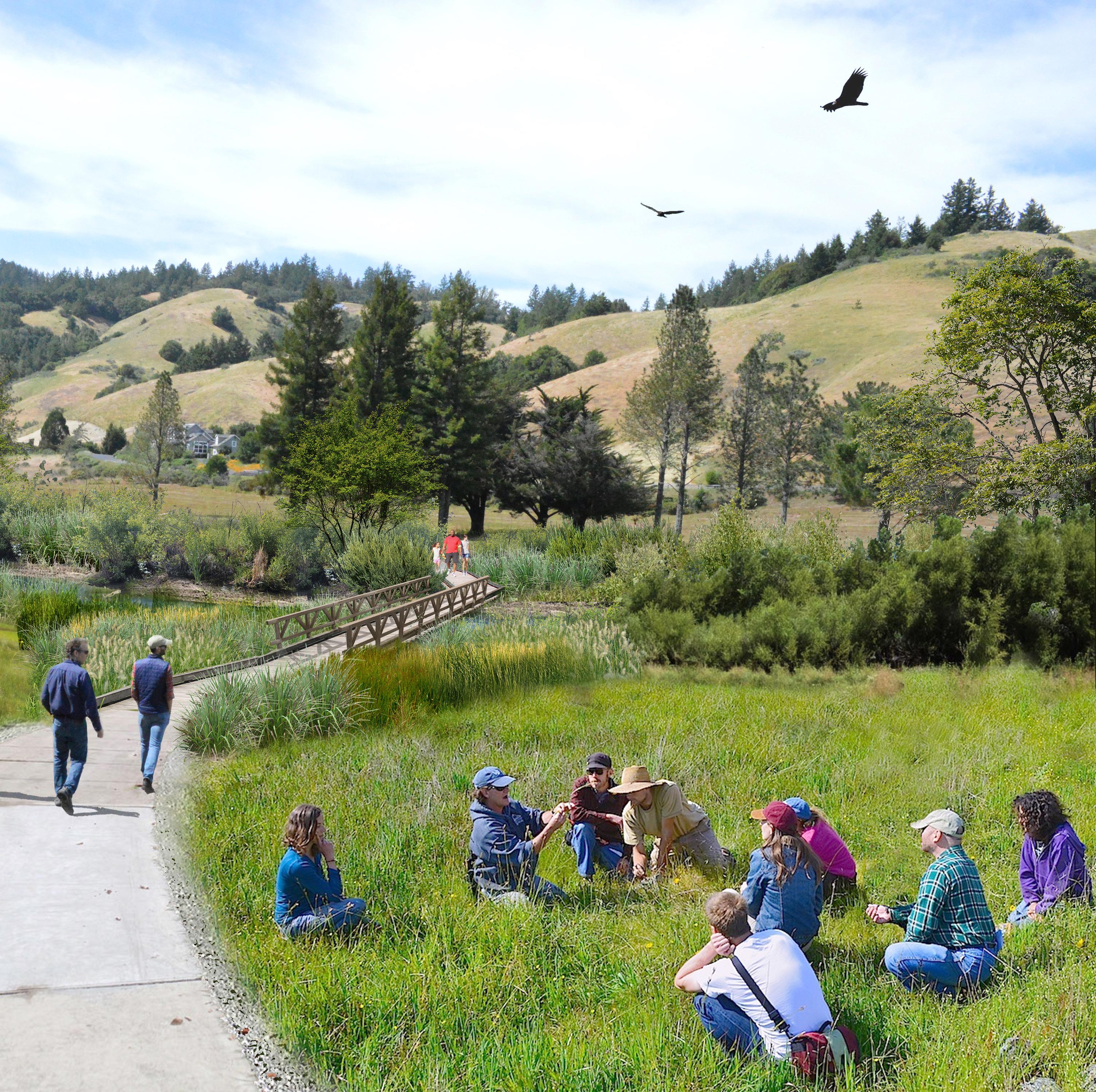
VISION CONCEPTS
Building upon the Site Opportunity Zones and Key Site Planning considerations, the project team developed vision concepts that further explore the interrelationship between site ecology, conservation areas, landscape, circulation/trail patterns, and compatible community uses - to create opportunities for memorable and meaningful experiences on the property.

C. Building a Vision 60
Bird’s Eye View Larsen Meadow Parcel

61
San Geronimo Meadow Parcel
The San Geronimo Meadow parcel is bounded by Sir Francis Drake Boulevard to the north, San Geronimo Valley Drive to the south and west, and the Marin Municipal Water District Water Treatment Plant to the east. Immediately adjacent to the parcel, on the west and south, are single family homes, a church, nursery and other community services. The Gary Giacomini Preserve is in close proximity, to the south.
The San Geronimo Meadow parcel supports a significant reach of San Geronimo Creek, which runs east-west through the broad valley floor, flanked by a mature riparian corridor and majestic heritage oaks. Adjacent open meadow areas reflect a transition from former irrigated golf uses to a more natural grassland community type, interspersed by four small constructed irrigation ponds supporting wetland

habitat. San Geronimo Creek connects to the broader network of streams in the Lagunitas Creek watershed, the largest watershed in the region and of state-wide significance for protected aquatic species. The San Geronimo Valley is one of the most ecologically important areas for salmon recovery in California. San Geronimo Creek provides vital habitat for endangered Central California Coast Coho Salmon and steelhead trout because it has not been dammed and there are fewer barriers than other streams in the watershed.
Because of the critical role that San Geronimo Creek plays as a primary spawning and rearing area for Coho Salmon and Steelhead Trout, restoration of San Geronimo Creek and its floodplain is a priority for this parcel. This Framework envisions extensive creek and floodplain restoration for the San Geronimo Meadow parcel with an emphasis on habitat restoration for
C. Building a Vision 62
Vision for San Geronimo Meadow

63
Coho Salmon, Steelhead, and other aquatic and riparian species that are supported there. The protection and enhancement of wildlife corridors will also be a priority. Complementary public access and quiet, low-impact recreation such as walking, natureviewing, and nature interpretation may co-exist here, but active recreation, agricultural activities, or structures of any kind are not compatible. Pet and horse access should be limited to specific through-trails to protect sensitive wildlife habitat, spawning and rearing fish, and other sensitive resources. Use of livestock for weed management should be closely monitored, and should avoid all riparian areas.
Conservation and restoration opportunities on the San Geronimo Meadow parcel include:
• Restoration and enhancement of floodplains
• Improved, more complex instream habitats that function across a range of future potential conditions for salmonids and other aquatic species
• Riparian corridor conservation and enhancement for habitat protection, wildlife movement, and ecosystem resilience
• Restoration and enhancement of wetland habitats
To minimize impacts to the natural resource values, these conservation and restoration priorities should inform future public access, placement of trails and pathways, and recreational and community opportunities on the San Geronimo parcel. Conservationcompatible programs and activities on this parcel may include the following ideas suggested by the community and public stakeholders:
• Well-designed and managed primary and secondary trails and tertiary footpaths, for example, a
multi-use trail running parallel to Sir Francis Drake Boulevard and outside of sensitive ecological areas to accommodate hikers, bicyclists, and horseback riders; and tertiary footpaths that allow for quiet contemplation of nature.
• Trailheads and connections to existing trails in adjacent open space areas, and connections that support safe routes to schools.
• Low-impact recreational activities including trail use, picnicking, outdoor gatherings and play in managed natural areas.
• Natural, historical, and cultural education and interpretation programs. Interpretive panels and use of existing structures for lowimpact nature education, including ecological, natural, historical, and cultural education and interpretation programs.
C. Building a Vision 64


65
Larsen Meadow Parcel

The Larsen Meadow parcel is bounded by Nicasio Valley Road to the east, West Nicasio Road to the north, and Lagunitas School Road to the southwest. West Nicasio Road is a private road that provides access to the French Ranch residential community and contains a public trail easement on its southernmost edge. Marin County open space surrounds the Larsen Meadow parcel. To the north is the French Ranch Open Space Preserve. The Maurice Thorner Memorial Preserve bounds the parcel to the south. Across Nicasio Valley Road to the east is Roy’s Redwoods Preserve, and the Lagunitas School and San Geronimo Valley Community Center border the southwestern edge of the property.
Larsen Creek and its tributaries are the primary features on the Larsen Meadow parcel. Additionally, there are open meadows, perennial and
C. Building a Vision 66
Bird’s Eye View San Geronimo Meadow and Clubhouse Parcel

67
intermittent streams, and seasonal wetlands. Larsen Creek and its tributaries are an important part of the effort to restore the broader Lagunitas Creek Watershed. While Larsen Creek, in particular, supports salmon and steelhead populations, there are other special status species that occur there as well. By virtue of its location amid three open space preserves, the Larsen Meadow parcel allows for uninterrupted wildlife movement. With deliberate restoration efforts, there is a significant opportunity to create wildlife corridors that connect the preserves together and support wildlife movement and migration. The Larsen Meadow parcel is envisioned to be a quiet restorative place in a natural open setting, with significant restoration potential, and opportunities for multi-use trails, outdoor education, nature interpretation, and low-impact facilities such as picnic tables and benches.
Conservation and restoration opportunities on Larsen Meadow parcel include:
• Creek channel and floodplain restoration including creek daylighting
• Improved stream flow for salmonids and other aquatic species
• Riparian corridor conservation for habitat protection and wildlife movement
• Wildlife corridor enhancement
• Restoration and enhancement of wetland habitats
C. Building a Vision 68
Vision for Larsen Meadow

69
To minimize impacts to the natural resource values, these conservation and restoration priorities should inform future public access, placement of trails and pathways, recreational and community opportunities on the Larsen Meadow parcel. Conservationcompatible programs and activities on this parcel may include the following ideas suggested by the community and public stakeholders:
• Well-designed and managed primary and secondary trails and tertiary footpaths, for example, a multi-use trail traversing the Larsen Meadow parcel from access points at the Clubhouse parcel and Lagunitas School Road, and footpaths to appropriate picnic areas
• Trailheads and connections to existing trails in adjacent open spaces areas, and connections that support safe routes to schools.
• Recreational activities in appropriate areas, including trail use, picnicking, bird watching, and outdoor gatherings and play in managed natural areas
• Nature education and interpretation
• Native plant propagation and harvest, and similar indigenous cultural practices
• Natural, historical, and cultural education and interpretation programs
• Fly casting ponds in suitable locations away from streams and drainages
• Managed dog access outside riparian, wetland and aquatic habitat areas
• Low-impact facilities such as limited picnic tables and benches, nature play using unpaved surfaces, and a restroom facility
C. Building a Vision 70


71
Clubhouse Parcel/ Community Commons
The Clubhouse parcel is at the intersection of Sir Francis Drake Boulevard and Nicasio Valley Road. Historically, it has served as the entrance to the property, marked by a gateway sign. This is the most developed area of the property with an existing clubhouse building from the former golf course, access roads, and a parking lot for 200 cars.
Because of its location between the San Geronimo Meadow parcel and the Larsen Meadow parcel, it plays an important role in connecting the northern and southern meadows of the property. This function is supported by the pathway tunnel under Sir Francis Drake Boulevard and the pedestrian bridge over Nicasio Valley Road.

When the property was a golf course, the Clubhouse parcel served as a popular venue for weddings, fundraisers, and other community
events. More recently, a local group started a community garden on the northeastern part of the parcel. While the San Geronimo Meadow and Larsen Meadow parcels have the greatest conservation and restoration potential, the Clubhouse parcel presents the most opportunity for recreation and other communityfocused programming. Because of its location on Sir Francis Drake Boulevard, safe and easy accessibility, distance from neighboring homes, and limited restoration potential, the Clubhouse parcel is also the most suitable location for a new Marin County fire station.
Possible future uses on the Clubhouse Parcel may include the following ideas suggested by the community and public stakeholders:
• Stand-alone Marin County fire station and related amenities
• VERG refuge or safe space area in event of emergencies
C. Building a Vision 72
Community Commons Rendering

73
• Multi-use trailheads, trails, and connections to existing trails in adjacent open space areas, and connections that support safe routes to schools
• Active recreation such as bocce courts, archery, kids’ playground, etc.
• Outdoor art and sculpture installations
• Garden and regenerative land management opportunities under two acres:
• Existing and/or new community gardens
• Native harvest garden
• Pollinator gardens
• Demonstration sites for rainwater capture, regenerative land management, permaculture practices, and related projects
• Fenced dog area
• Outdoor community events:
• Farmers’ markets
• Outdoor concerts and local music venues
• Indigenous cultural, educational, and ceremonial uses
• Commons area for organized and spontaneous social and recreational uses, such as family picnics, pop-up food spots,
• Community-serving uses in the former golf course clubhouse:
• Administrative space for the Marin County Fire Department
• Local nonprofit meetings and administrative space
• Community classrooms and meeting space
• Community Center programming, including job skill and youth services, art and cultural events, and social service programs
• Business incubator space
• Teen center
• Nature education programming
• Maker spaces, artist studios and/ or galleries
• Museum/historical/cultural exhibits and uses
• Reference library
• Wildlife Corridors
C. Building a Vision 74


75
The Former Golf Course Clubhouse
Re-purposing of the existing Clubhouse building presents a possible venue for integrated fire and community functions, with portions of the building potentially accommodating Marin County Fire Department administrative and storage needs, and portions serving mixed-community functions. For example, the former clubhouse could serve as a space for meetings and trainings, educational programming, nonprofit and/or community center programming, maker and artist studies, etc. The Clubhouse could also serve as an anchor for outdoor events, such as farmers’ market, community celebrations, and recreational events. Given its central location within the valley, accessibility, large parking lot, and adjacent public open space opportunities, the Clubhouse location is ideal for such uses.
Community Benefit Zone
Tied to the use of the Clubhouse building is the area of the property most heavily devoted to communityfocused uses and amenities. Here, the parking lot could act as the primary setting off point and trailhead for park and open space users, and the community gardens would further define this space as a social hub. Across the driveway, open space areas could be set aside for activities and community programming that are not appropriate for the more ecologically sensitive San Geronimo and Larsen Creek Meadow areas. This is the most suitable area for a future fire station, which would serve as an important community asset in this area. Plantings and visual enhancements could provide a buffer between community and fire department spaces.
C. Building a Vision 76

77
Community benefit on Clubhouse Parcel
Primary Parking Area / Trailhead
The main parking area adjacent to the Clubhouse would continue to serve as the primary setting-off point for visitors to the property. With a capacity for close to 200 vehicles, the existing parking area provides abundant space for users of the open space and community areas. Consideration should be made for stormwater runoff at the parking lot, which could be managed or treated through the introduction of retention basins or filtration gardens surrounding the paved area.
Community Gardens and Regenerative Land Management Area
As a well-loved asset already existing on the property, the Vision Framework seeks to protect and potentially expand the area of the community garden within the Clubhouse
parcel to accommodate additional gardens, a native harvest garden, pollinator-friendly plants, and/or demonstration sites for regenerative land management activities such as rainwater capture, infiltration, carbon sequestration, and other demonstration projects focused on soil health, stormwater management, and aquifer recharge. This area would be integral to the social and community nature of the Clubhouse parcel, and representative of the community’s values, including land management and ecological stewardship, nature education, and the importance of communal gathering and interaction.
C. Building a Vision 78

79
Former golf course clubhouse as a community amenity

D. CASE STUDIES
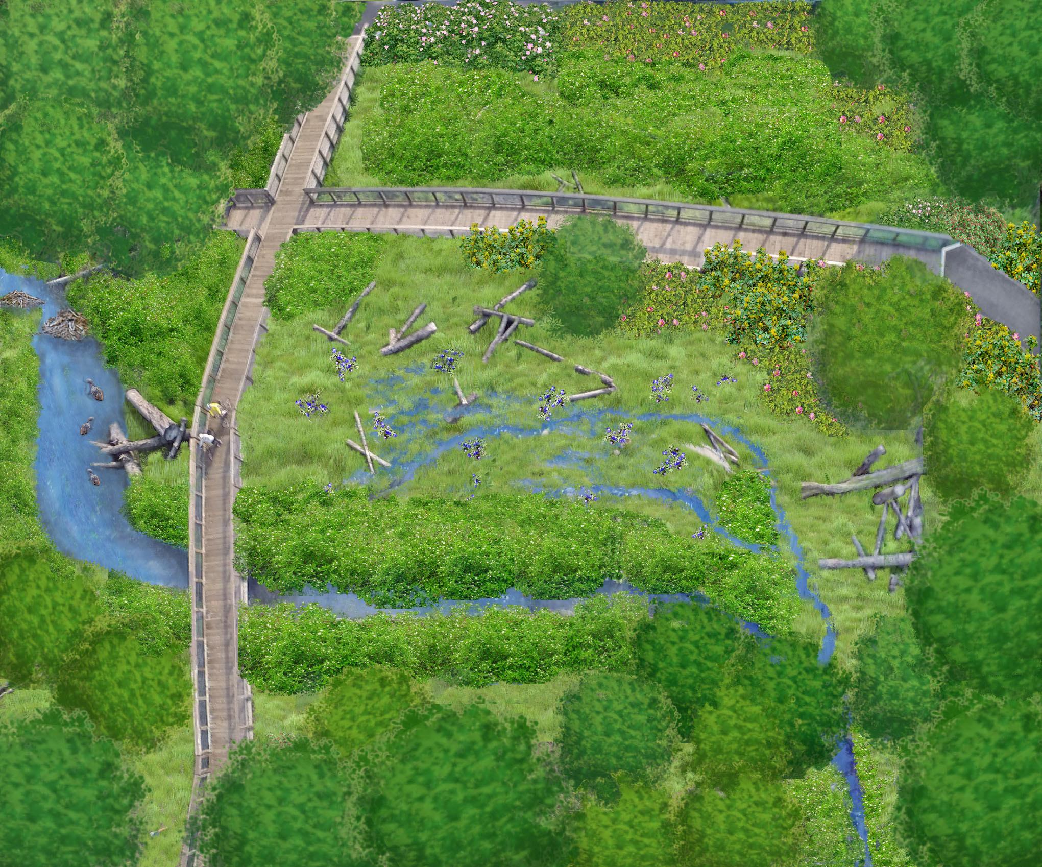
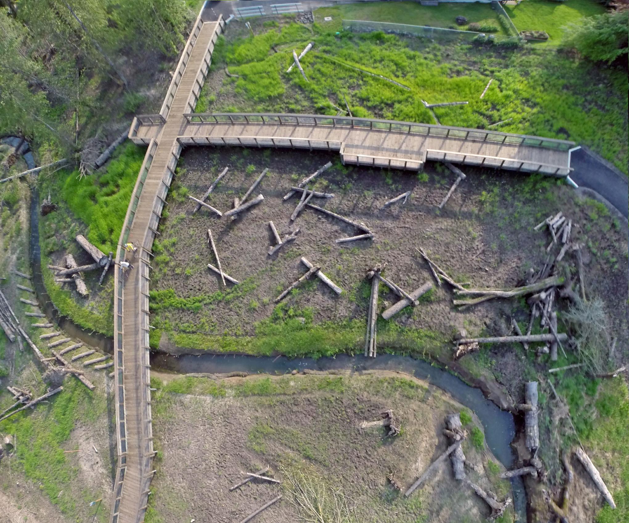
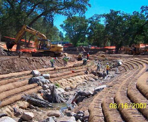
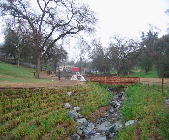
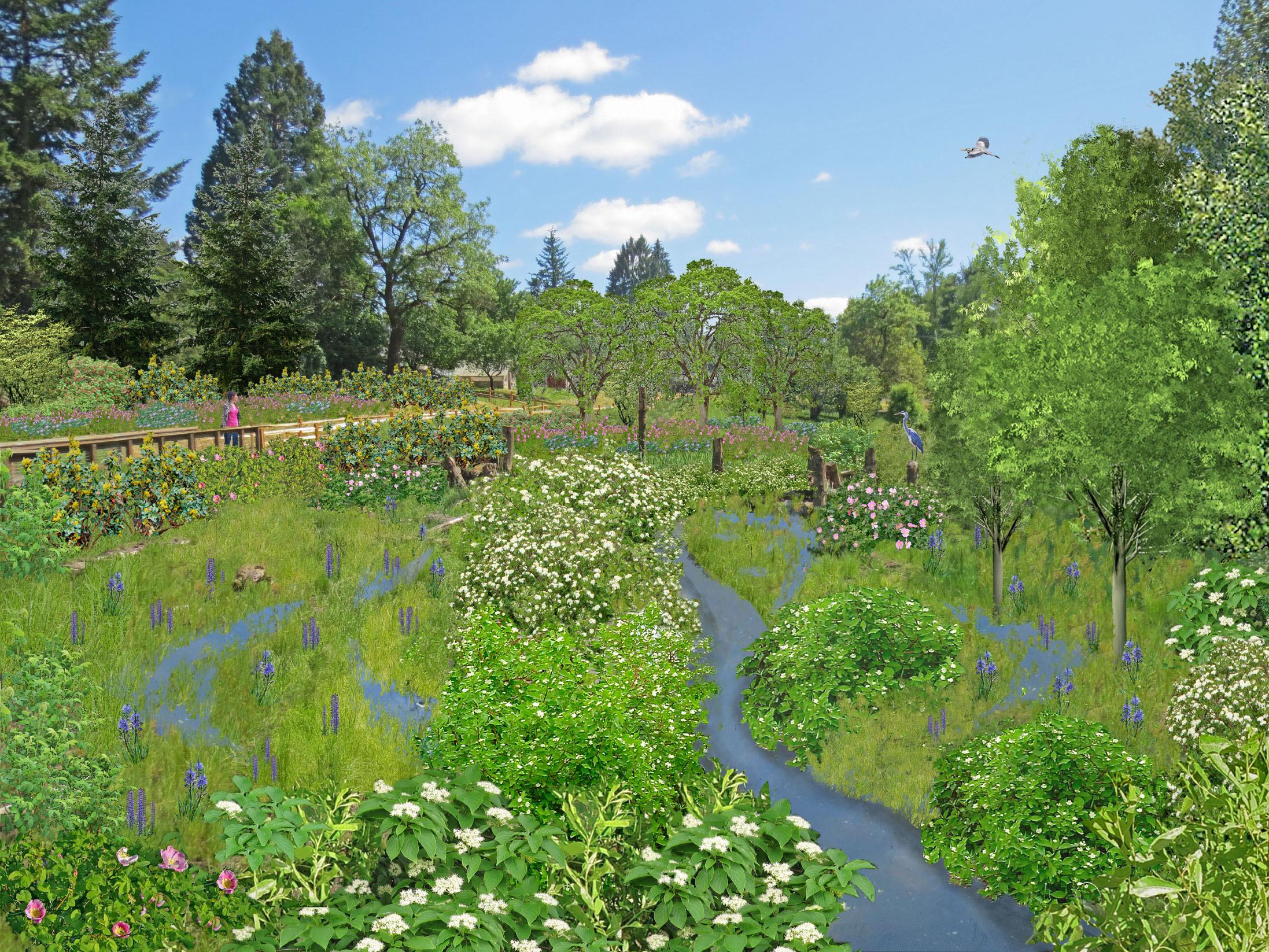
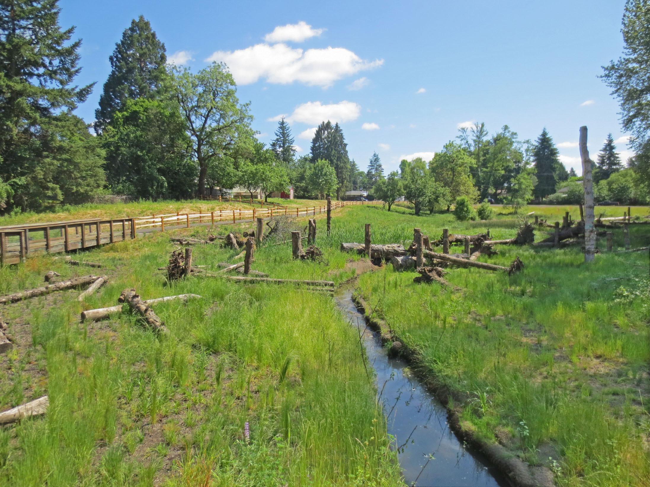
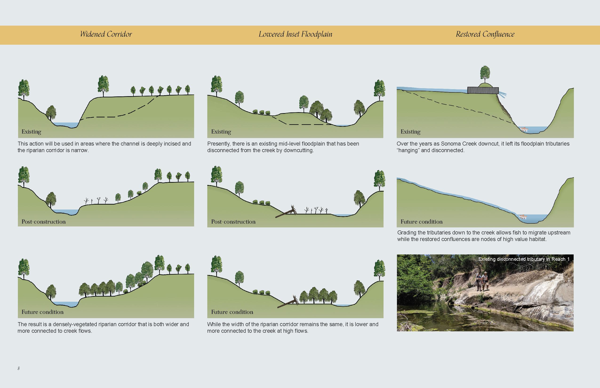
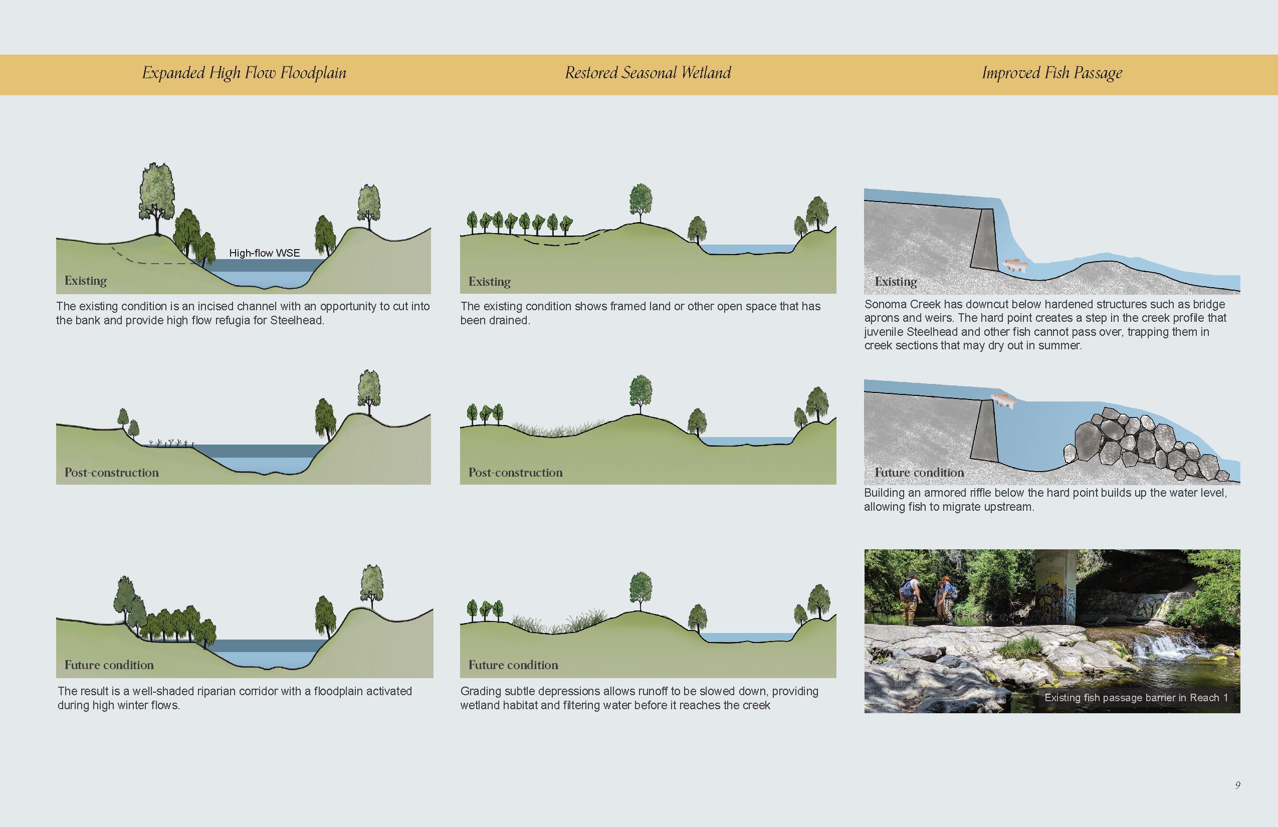
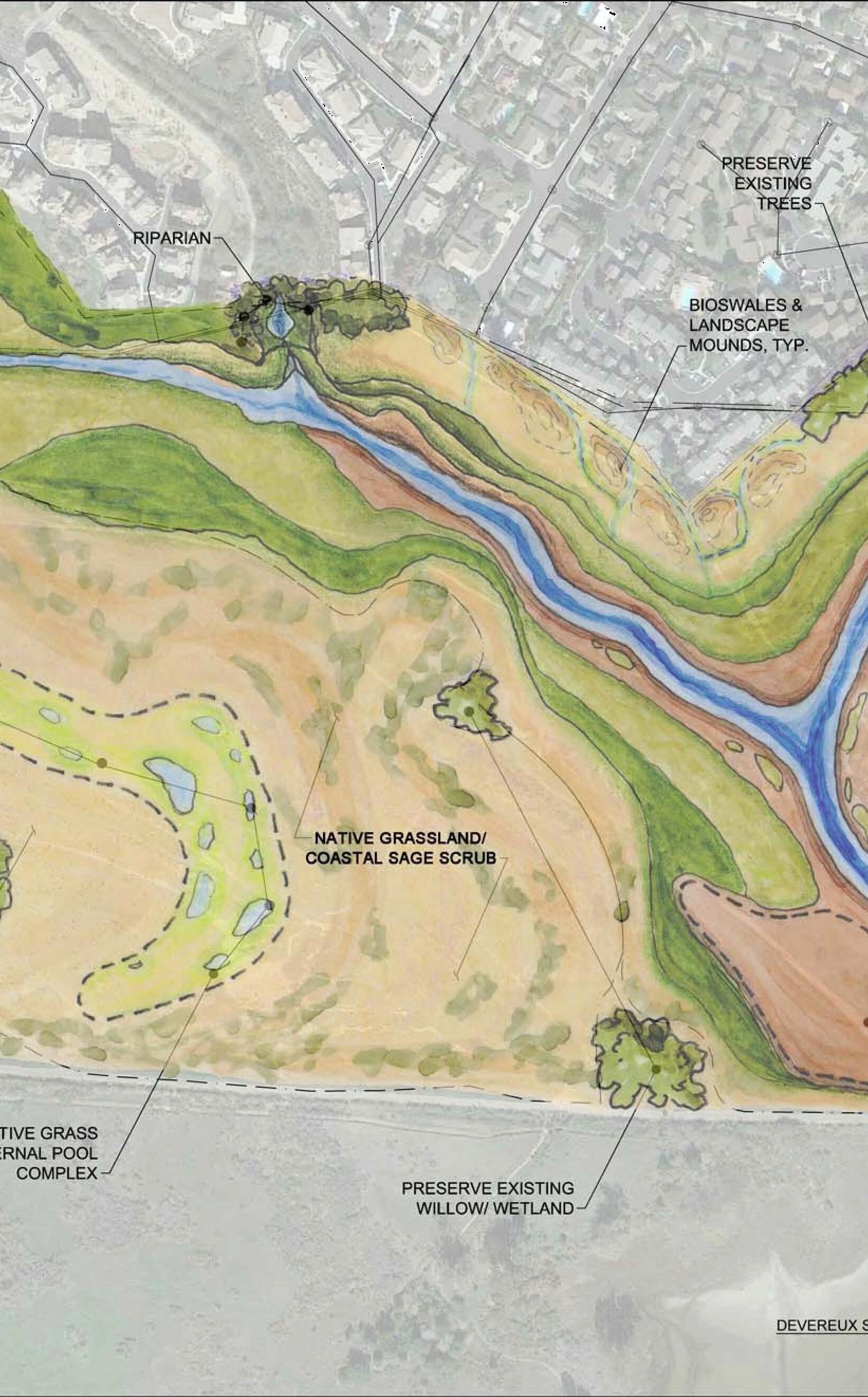
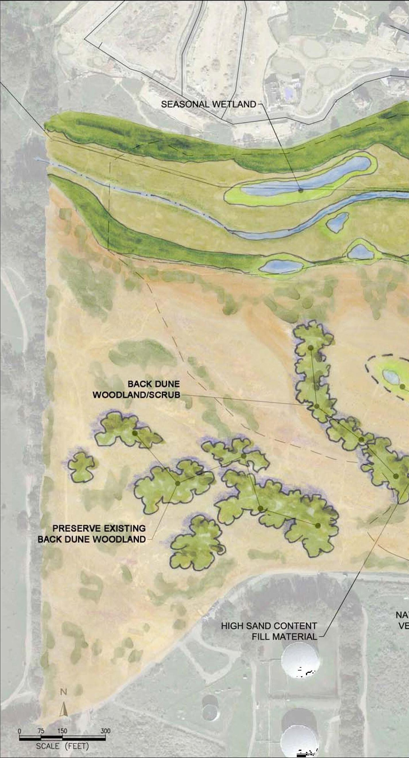
B
SOURCE: Aerial Photo: Google Earth, 2015. Topography: Aerial Photogrammetry June 13, 2006 by Arrowhead Mapping Corporation
AQUATIC/SUBTIDAL MUDFLAT/SALT FLAT


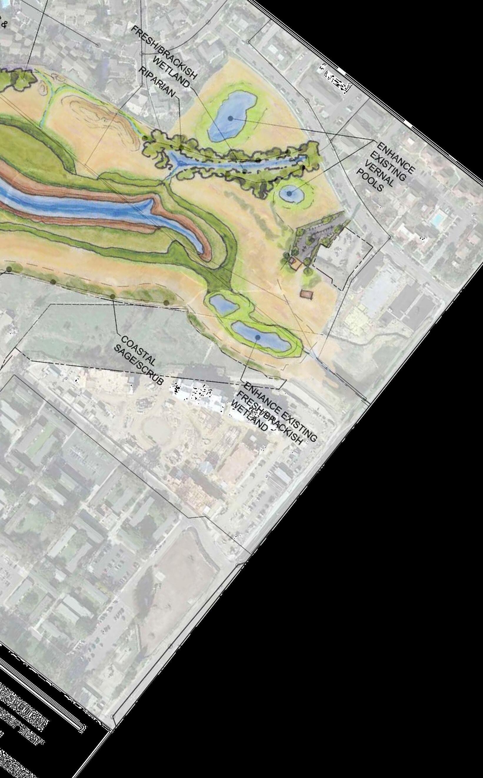
MARSH PLAIN

HIGH MARSH/TRANSITION
UPLAND


UCSB NCOS RESTORATION PROJECT . D140769
24
DEVEREUX SLOUGH
FIGURE
LEGEND
A
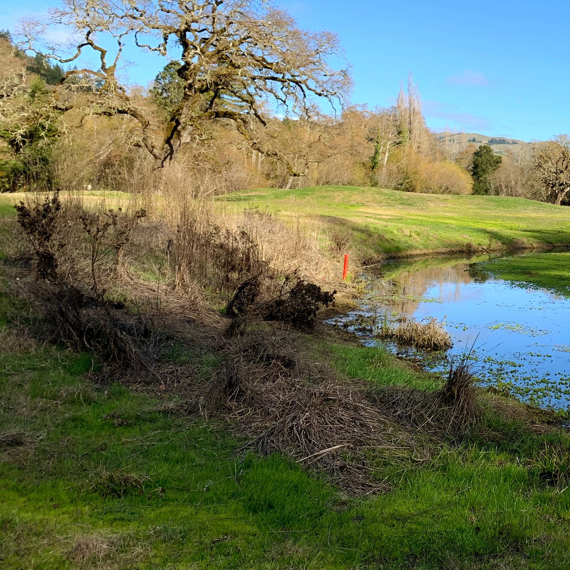
E. REFERENCES
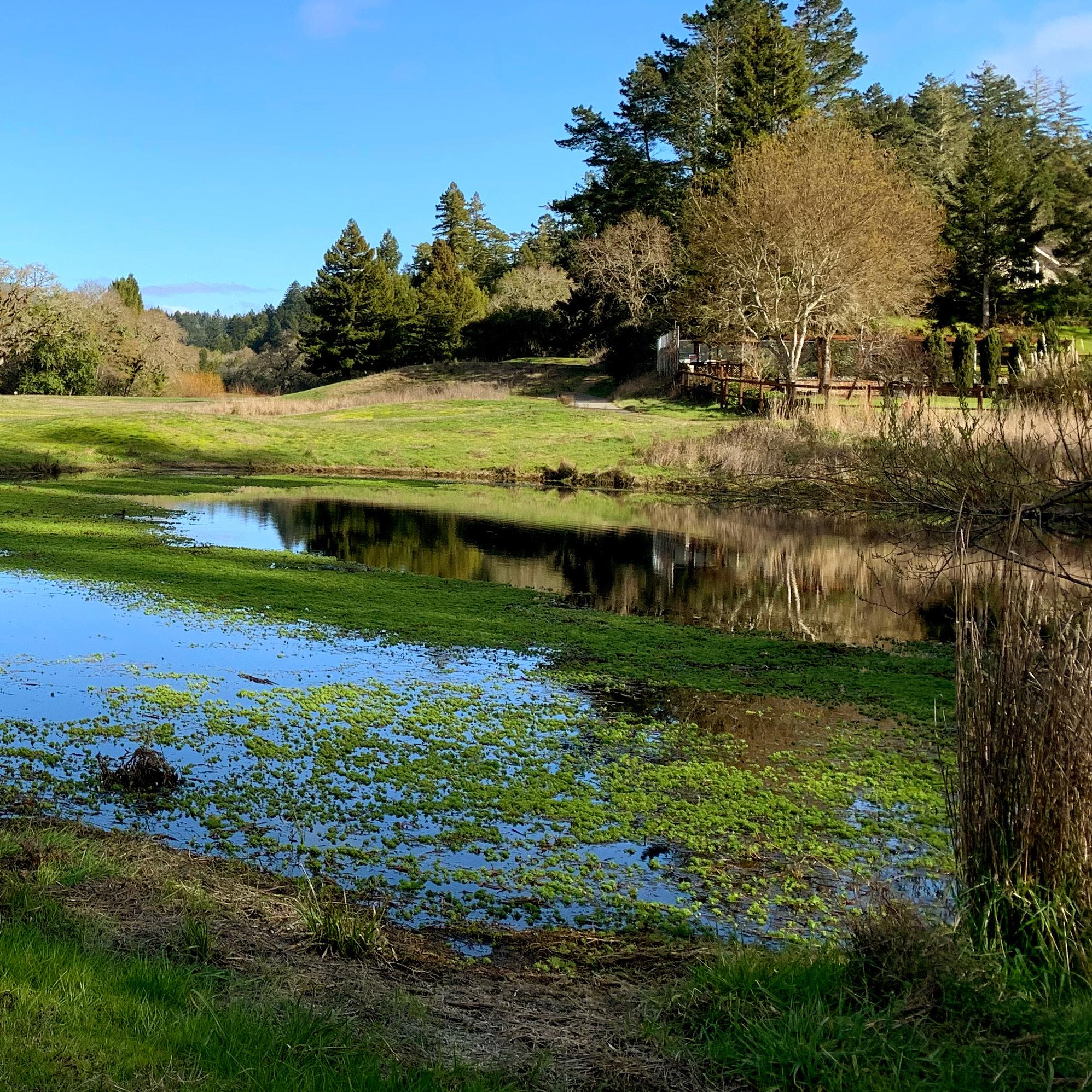
E. REFERENCES
“Community Guide 2017.” San Geronimo Valley Community Center, 2017. https://www.sgvcc.org/wp-content/ uploads/2020/08/CommunityGuide2017_Online_01.pdf.
Joe Sanchez, documented MLD (most likely descendent) Coast Miwok by the Bureau of Indian Affairs, and member of the Coast Miwok Tribal Council of Marin County
Lindsay, Rebecca. “How Do We Know the Build-up of Carbon Dioxide in the Atmosphere Is Caused by Humans?” NOAA Climate.Gov, November 5, 2020. https://www.climate.gov/ news-features/climate-qa/how-do-we-know-build-carbondioxide-atmosphere-caused-humans.
Lindsey, Rebecca. “Climate Change: Atmospheric Carbon Dioxide.” Nature 453, no. 7193 (May 2008): 379–82. https://doi. org/10.1038/nature06949.
Change Is Making It Worse.” Union of Concerned Scientists (blog), September 9, 2019. https://blog.ucsusa.org/pabloortiz/the-world-is-in-a-water-crisis-and-climate-change-ismaking-it-worse.
“San Geronimo Community Plan 1997.” Marin County Board of Supervisors, 1997. https://www.marincounty.org/-/ media/files/departments/cd/planning/currentplanning/ publications/communityandareaplans/san_geronimo_ community_plan_1997.pdf.
Schottland, Taj. “Parks as a Solution to Climate Change.” NRPA “Parks and Recreation” Magazine, April 5, 2019. https:// www.nrpa.org/parks-recreation-magazine/2019/april/ parks-as-a-solution-to-climate-change/.
Climate Change: Vital Signs of the Planet. “The Causes of Climate Change.” Accessed November 24, 2020. https:// climate.nasa.gov/causes.
Mulkern, Anne C. “Fast-Moving California Wildfires Boosted by Climate Change.” Scientific American, August 24, 2020. https://www.scientificamerican.com/article/fast-movingcalifornia-wildfires-boosted-by-climate-change/.
Ortiz, Pablo. “The World Is in a Water Crisis and Climate
E. References 94
95
F. Acknowledgements 96
