

YANQI LAKE


Forest eco-park
Regional park
Connectivity park
Ecological park
Linear park
Landscape park
Balancing Environmental Conservation and Development
With the relentless rise of China on the world stage, Beijing authorities are looking to reposition the city of Yanqi Lake, located northeast of Beijing, as a global destination for conventions and exhibitions.
Using a cross-disciplinary approach, we brought together disciplines as varied as ecological and environmental planning, land assessment, real estate strategy and event planning, to complement a robust sustainable design and transportation planning approach to the brief.
We coordinated the overall initiative and conducted the research and analysis related to issues of water quality, environmental conservation, and social and landscape considerations. The resulting masterplan incorporates strategies for the orientation and placement of new buildings, reduction of pedestrian/ vehicular conflicts and revitalization of open spaces.
Project Role Statement
In order to approach the eco-friendly development, we had some chapters detailing environmental strategies particularly in this project. Besides helping on studying and developing conceptual masterplan, I was responsible for the overall landscape development and environmental design guidelines, including riparian landscape, open space, streetscape and green resortation.


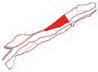
NEW TAIPEI CITY RIVER FRONT LANDSCAPE DEVELOPMENT
New Taipei City, Taiwan, 2012-2013
New Taipei City Gov | waterside open space of 5 rivers
Story of Water
The project was comprised of the 5 major rivers within the city. The individual proposed plans for each rivers will not only satisfied its initial purpose – flood control, but also enhance the life style of the surrounding neighborhoods. Together, they share a vision and recourses for a bigger and better green and blue system within the city.

Landscape Architectural Design and Planning of Dahan River
After proposing position and strategy of each river, we have to provide further landscape design of Dahan River. Using the distinct characteristic of the river itself as the story line, the goal is to create a place not only for its great recreational value for the people among the region but also to execute it in a more environmentally responsible way.
Project Role Statement
In first stage, I worked on overall site study and analysis of all the 5 rivers to characterize each of them and give the story line of the project. In the fallowing stage, I helped on producing overall diagrams and lighting design of Dahan River. In addition, I was responsible for part of view collages and waterfront sections respected to the environmental conditions.


Linkou River
Red Narcissus River
Dahan River
Xindian River
Beishih River


Da-Han River Site


Riverside Scenery of Left Bank
Main Landscape Scenery of Left Bank
Transforming of Hou-Tsun Weir/Dam

Landscape Scenery of Right Bank


Prairie Landscape
Waterfront Landscape
Mixed Forest Landscape Trail
Schematic Diagram of Riverside Ecosystem
CAOFEIDIAN INTERNATIONAL ECO-CITY TOURISM PLAN
Caofeidian, Tangshan, China, 2011
Plan and construction Bureau of Caofeidian International Eco-City | 2600 Ha
Eco-tourism Destination
This is a competition project for proposing a ecological tourism town in Caofeidian. First, we had to repositioning of the site, based upon analysis of its natural characteristics and adjacent developments. Giving recommendations on the use of inner harbor islands, coastlines, and functional subdivisions. Then applying sustainability design principles to adhere to the Eco City concept. Take into account cost efficiency to make it an exemplary inner harbor resort/ destination.
Project Role Statement
As one of the main project members, I was responsible for all the design diagrams, collages and the final animation production.

Tourism and ecological programming: Take into account local climate and the geography of the Caofeidian Eco City when recommending programs.


District 2 - Pier
District 3 - Marina
District 4 - Archipelago
District 5 - Peninsula
District 6 - Coastal Islands
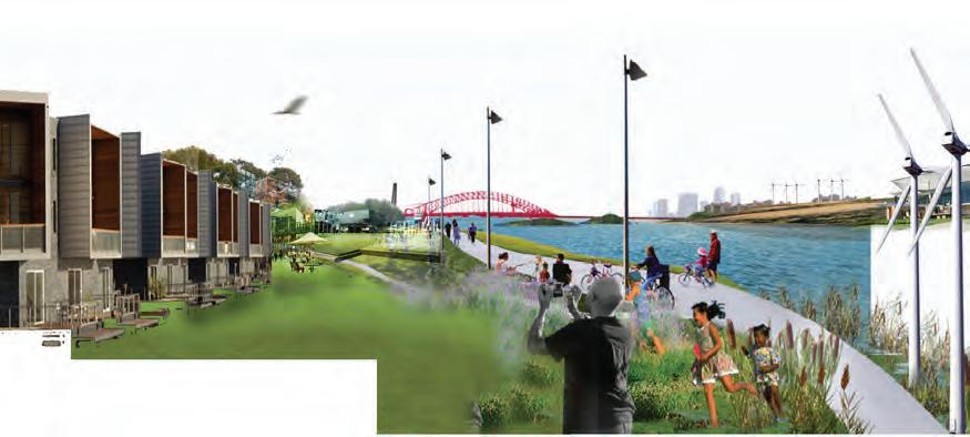
FRANCES BAY
WATERFRONT MASTER PLAN
Darwin NT, Australia, 2015 Toll Holdings | 7.795 Ha
A New Waterfront Precinct
This visionary master plan was prepared for the site, which is currently an industrial working waterfront at Frances Bay, located immediately to the east of Darwin City Centre on the waterfront of Port Darwin.
Embracing its working waterfront past, long, thin finger wharves immerse the site in its waterfront context and are home to a variety of waterfront apartment typologies including central breezeways, terraced rooftop gardens and marina access. Private residents’ recreation clubs and a 6 star hotel terminate the piers creating waterfront destinations. New parklands are activated with dining precincts and event spaces as well as swimming lagoons and waterplay.
Project Role Statement
I was part of the urban/landscape design team in cooperating with the economic team to feasibly deliver the development program and master plan. I participated in developing the site context, analysis, master plan, built form and final visualization.


Key Design Principles
Illustrative Master Plan


Indicative Perspectives of Future Development
CAPTURE COOLING BREEZES AND SHADE PUBLIC SPACES
A VARIED WATERFRONT EXPERIENCE A CITY OF CONNECTED PRECINCTS
WATERFRONT
1
YUNDANG LAKE URBAN & LANDSCAPE MASTER PLAN
Xiamen, China, 2012-2013
Xiamen CIty Planning Bureau | 358 Ha (42% water area)

City Living Room

Green Subcenter - 5km Sustainable Corridor

Urban Acupuncture
Project Role Statement
I participated in the preliminary design, in which my team proposed scheme 2 and worked out relating drawings (as above second one). On embodiment of eco-park, we are trying to transform YunDang lake as an ecological corridor across Xiamen city center, but also to consolidate its surrounding open space system, be part of the green belt system in Xiamen.


Optional Schemes in Satge 2: Scheme 2 was adopted for further development.


Urban and Landscape Strategies
The ultimate goal of this project was to establish a sequence of ecological, accessible, iconic, and sustainable world-class destination.
Creating new urban landscape, represent YunDang Lake as a new city images of Xiamen is to maximize the sustainable development of lake ecosystems, to create organic urban park.


Landform Plaza
Overall Perspective View
Lakeside Night Scene
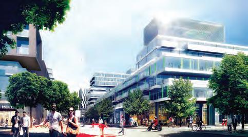
LIVERPOOL STADIUM & ENTERTAINMENT PRECINCT CONCEPTUAL MASTER PLAN
Liverpool NSW, Australia, 2015
Liverpool City Council | 26.56 Ha
Western Gateway to Liverpool CBD
In collaboration with Populous, a conceptual master plan is delivered to accommodate the new Liverpool stadium and mixed use sports precinct closed to Liverpool CBD.
Aiming at creating a sense of ‘place’, a destination point in Liverpool for a mix of uses that includes high quality sporting facilities, hotels, residential apartments and community facilities, the precinct master plan covers landscape design, programming, built form options and yield.
Project Role Statement
I was involved in the urban context analysis, master planning, built form and yield investigation as well as the final visualization and illustrative master plan.


Community Precinct - Culture Center concept design
Community Precinct and associated parkland design
Indicative images of public realm
Stadium Precinct and associated mixed use development


Stadium Design - Cantilevering Waffle © Populous
TAICHUNG GREENBELT
Taichung, Taiwan, 2010-2011
Taichung Planning Bureau | 12 Ha
Known for its rich artistic and cultural fabric, Taichung was awarded the title of “World’s Best Cultural and Art City” by the World Leadership Forum in 2007. Keen to promote the city’s cultural scene and its commitment to sustainability, local authorities approached our team to transform Taichung’s existing greenbelt landscape into one that incorporates innovation, sustainability and recreation within an artful design framework.
Project Role Statement
As an urban designer and a landscape design assistant in this project, I helped on developing street furniture and coordinating with local landscape design firm for checking CAD detailed drawing. I was also involved in the final report production where I mainly focused on producing zoning landscape perspectives and relating sections.
Implementation
Designed with bio-swales and other mechanisms to achieve the goal of a 100 percent rainwater recycling system, our schematic design and detailed development is carried to construction documentation through our local partners in Taiwan.


Unifying the City
Situated at the intersection of the new and historic towns, this greenbelt will become the new Central Green Spine for all of Taichung, unifying the two parts of the city.
Linking Amenities
The alignment of the park links major cultural facilities, universities, commercial centers and residential neighborhoods throughout Taichung. The new improvement scheme will also significantly raise the land value of the surrounding areas.


New Town
Historic Town Central Green Spine
Intersecting Greenbelts
SYDNEY SCIENCE PARK MASTER PLAN & 1ST COMMUNITY PRECINCT
Luddenham NSW, Australia, 2015- current Celestino | 287 Ha
Sydney Science Park is located in the strategic ‘Western Sydney Priority Growth Area’ at Luddenham. It is an AUD 5 billion project that will create an internationally recognized epicenter for research and development in the heart of Western Sydney. Sydney Science Park is designed to be a place to live, learn, work and play. It will foster innovation and cultural development in science and technology in the context of a vibrant, integrated community. The First Community Precinct will be the inaugural phase of this great vision.

The master plan aims to create a new mixed use community with a focus on scientific enterprises, R&D, educational institutions, residential and a town centre - all of which will be supported by a multi-modal transport and green infrastructure network.


Project Role Statement
I have been involved in producing both overall Sydney Science Park master plan and delivering the Stage 1- First Community Precinct Plan. Focusing on urban design and setting development controls, I helped to restructure the overall master plan, producing analysis , design principles and control diagrams and 3D visualization.
Access and Servicing
Science Park Master Plan -
Sydney Science Park 1st stage- Boulevard and Park
A place to live, learn, work and play Common Areas
Orientation and Design Pocket Greens and Connections
Key Urban Design Principles


Pedestrian Walkway & Pocket Parks
Linear Waterside Park & Mixed use area
Waterside pedestrian/cycle path & Urban Plaza
Waterside Landscape & Amphitheatre
Placemaking and Wayfinding
Corners


Project Role Statement
I fully participated in this project. As an assistant project manager, I had to communicate with the client and negotiate with local government. Besides doing urban design and all the relating productions, I was also responsible for preparing presentation and team/project management.


The
of Jiaozhou Bay
The vision for the Jiaozhou Bay New Town East District is defined as: “The Haiyue District, The pearl of Jiaozhou Bay”
- to create an ecological coastal district with waterfront life style, supportive industry and green environment.
- to drive the urban development around the Jiaozhou Bay area, so as to enhance the competitiveness of the Greater Qingdao region and the quality of living environment.


Strategy Create a Clear Overall Image with Distinctive Zones
pearl
NEW TOWN
CONTROL PLANNING GUIDELINES OF HUATIAN ZHANGBEI RESORT
Zhangjiakou, Hebei, China, 2009-2010
Theme Lifestyle Resort
Zhangbei Resort is a tourist real estate development project targeting the high end. The programs within the development include an equestrian park, golf course, ski center, SPA boutique hotel, outwardbound training center, resort villas, commercial development and other tourist amenities. Refer to the previous conceptual master plan, the project aims to provide regulatory detailed planning and guidelines for each district.
Project Role Statement
Following the conceptual master plan which proposed an integrated resort destination in previous stage, this project is to provide control planning guidelines for four of the main districts, including Equestrian Lifestyle Community and Ski Lifestyle Community. I helped on revising the master plan and diagrams to cater for client’s development requirement. I also built up the 3d model and focused on proposing guidelines and control planning of Tourist Town Center District.
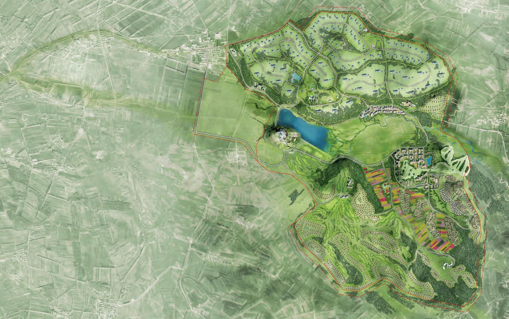

Masterplan


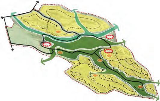
Overall Spatial Structure

Equestrian Community District
Tourist Town Center District
Ski Community District
3.廈門面對海西競爭的焦慮,加速推動對台政策
以國際觀光為目標的觀光遊憩構想
整體觀光發展構想
利用五星級聚落形塑金門獨有的觀光特色
International tourism plan
翔安國際機場將加速帶動海西區域的國際化
Overall tourism development plan
1.新機場規劃帶動城市發展重心東移
Special tourist attraction : 5 star traditional villages
2.爭取兩岸共享機場,掌握國際脈動
3.Xiamen
冷戰遺址轉型為多元的觀光主題
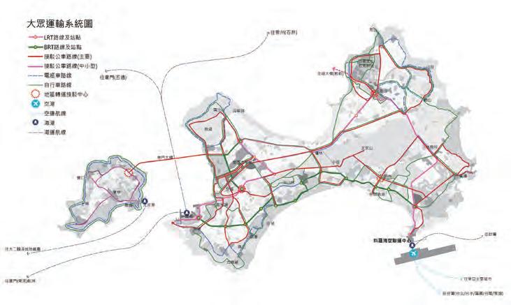
KINMEN COUNTY CONCEPTUAL MASTER PLAN
From cold war legacy to attractive scenic spots
1.Building the airport drives the city development focus move towards the east
2.The airport is expected to be shared by both China and Taiwan
3.Reserve the land and infrastructure for future development related to the construction of Xiangan Airport and Jindeng Bridge
3.預留翔安機場及金嶝大橋興建後的發展腹地及配套措施
Kinmen, Taiwan, 2011-2013
國家公園傳統聚落
Kinmen County Gov | 155.37 sqkm
A級自然村
B級自然村
金門奇蹟/願景與定位
C級自然村
計畫發展範圍
發展影響示意
Kinmen Miracle/ Vision and Positioning
對於臺灣:臺灣第一座智慧島嶼
For Taiwai: the first smart island Position of Kinmen
4E金門
Eco: sustainable eco-island: 21 century new low carbon living island
Eco永續生態島 21世紀新型態低碳生活的幸福宜居島嶼 Event國際旅遊島 觀光渡假及魅力產業的國際旅遊目的地
Event: international tourism island: international tourism destination for vacation with characteristic industries
善用臺灣高科技產業優勢為基礎,以及面積適宜、可行性高的特性,由中央政府協 助金門朝向智慧島與的方向發展,透過高科技基礎設施及高速網路的建構,排除因 距離而產生的隔閡及限制,建構智慧管理系統,提昇金門的生活品質,也讓金門成 為臺灣科技實力的展示櫥窗。
自然村/聚落分布圖
E-Island先鋒智慧島 引領跨界經濟與創新生活的先鋒智慧島
Entrust海峽服務島 提供海峽兩岸值得信賴的個人與商務服務 定位金門
生態休閒度假旅遊
自然生態及鳥類觀察
A1:古寧頭及慈湖地區
A2:烈嶼
森林公園
B1:中山林地區
B2:太武山地區
Ecotourism
海岸地質觀察
C1:金西南海岸
C2:金東北海岸
主題發展區
D1~D5:田園、海岸及森林風光
The location of villages
生態觀光活動路徑

生態觀光資源分布圖
The location of ecotourism resource
金門焦點
/重點示範地區
烈嶼生態慢活渡假島
與家人及朋友共享歡樂時光的國際度假勝地 濱海渡假金烈灣
集海灣渡假、購物娛樂、休閒生活為一體的國際海灣
Project Role Statement
南村落黃金海岸
與綿長海灣比鄰的國際渡假休閒 金東生態休閒渡假林
帶動國際旅遊發展的海濱高爾夫球場
E-Island: pioneering smart island: smart island crossing over economy and innovative life
建構金門的黃金旅遊軸線 構想:一島一軸 策略:串連與整合
冷戰遺址資源分布圖
The location of cold war legacy
Entrust: strait service island: provide reliable personal and business service for both sides of Taiwan Strait
Kinmen Golden tourism axis
Concept : one island and one axis
Strategy : linkage and combination
金東生態休閒渡假林
南村落黃金海岸
濱海渡假金烈灣
烈嶼生態慢活娛樂島

The target aims to develop Kinmen from past borderland into an economic and trading front line across Taiwan Straits and an international ecological holiday island ,which is based on the Touchstone policy of the ECFA era, national development strategy of low carbon ecology, reservation and redevelopment of historical villages.
Key areas
Lieyu : LOHAS island
黃金旅遊軸線構想圖
Kinmen Golden tourism axis
•International holiday resort with family and friends
International vocation beach
•International vocation beach with recreational and leisure life
Golden sea shore along south villages
•International resorts with the long beach
Eco resort in east Kinmen
•Coastal golf club
海西文化教育新城
I was involved in the second stage of this project, where I mainly helped on developing three of the focal areas as design and planning demonstration(see as below). Since this project aimed at the strategy and vision for the future development rather than practical planning and design, I spent 1 week for site exploration and understanding. I also helped to revise the design strategy and diagrams of the previous stage, and then the final report production.
展現金門獨有文化特色與國際教育優勢的新城鎮


A new collage town
•A new collage town with special culture and international education


以國際觀光為目標的觀光遊憩構想
整體觀光發展構想 利用五星級聚落形塑金門獨有的觀光特色
International tourism plan
冷戰遺址轉型為多元的觀光主題
From cold war legacy to attractive scenic spots
Overall tourism development plan
Special tourist attraction : 5 star traditional villages
國家公園傳統聚落
建構自給自足低碳島的策略
建構自給自足低碳島的策略
A級自然村
B級自然村
C級自然村
計畫發展範圍
發展影響示意
水資源利用及管理策略 ‧綜合水資源管理 ‧水資源供給方案
水資源利用及管理策略 ‧綜合水資源管理 ‧水資源供給方案
Water resources usage and management strategy
Water resources usage and management strategy
•Water resource management
•Water resource management
•Water supply strategy
•Water supply strategy

生態休閒度假旅遊
能源供應及管理策略 發展智能電網 發展再生能源 與大陸買電
能源供應及管理策略 發展智能電網 發展再生能源 與大陸買電
Ecotourism
海岸地質觀察
自然生態及鳥類觀察
A1:古寧頭及慈湖地區
水資源供需量預估(目標年:2030年)
水資源供需量預估(目標年:2030年)

能源供需預估(目標年:2030年)
自然村/聚落分布圖
The location of villages
生態觀光活動路徑

建構金門的黃金旅遊軸線 構想:一島一軸 策略:串連與整合
冷戰遺址資源分布圖
The location of cold war legacy
Kinmen Golden tourism axis
Concept : one island and one axis
Strategy : linkage and combination
Energy supply and management strategy
Energy supply and management strategy
A2:烈嶼
C1:金西南海岸
•Develop smart electric grid
C2:金東北海岸
•Develop smart electric grid
森林公園
•Develop renewable energy
•Develop renewable energy
主題發展區
•Buying electric power from Xiamen
B1:中山林地區
•Buying electric power from Xiamen
D1~D5:田園、海岸及森林風光
B2:太武山地區
2030年供水比例,自給自足方案
2030年供水比例,自給自足方案
Water supply
南村落黃金海岸
濱海渡假金烈灣
烈嶼生態慢活娛樂島
2030年供水比例,境外引水方案
生態觀光資源分布圖
Water supply plan in 2030 : import from Xiamen
The location of ecotourism resource
金門焦點/重點示範地區
以集約發展為導向的空間架構
烈嶼生態慢活渡假島
以集約發展為導向的空間架構
三個發展核心
三個發展核心
與家人及朋友共享歡樂時光的國際度假勝地 濱海渡假金烈灣
三個特色發展帶
三個特色發展帶
一個綠色走廊
一個綠色走廊
Compact Development Oriented Spatial Framework
•Three development cores
•Three development cores
集海灣渡假、購物娛樂、休閒生活為一體的國際海灣 南村落黃金海岸
三個生態旅遊區
三個生態旅遊區
一個生態慢活娛樂島
一個生態慢活娛樂島
Compact Development Oriented Spatial Framework
能源供需預估(目標年:2030年) •Land use planning principles •Development types Water supply plan in 2030 : self sufficient Energy supply plan in 2030
•Three characteristic development belts
•One green corridor
•One green corridor
•Three eco-tourism areas
•Three eco-tourism areas
•One eco-recreational island
與綿長海灣比鄰的國際渡假休閒
•One eco-recreational island
金東生態休閒渡假林 帶動國際旅遊發展的海濱高爾夫球場
海西文化教育新城
展現金門獨有文化特色與國際教育優勢的新城

增加價值的土地使用優化構想
增加價值的土地使用優化構想
土地利用系統規劃原則 開發情境分類
土地利用系統規劃原則 開發情境分類
Optimization
Key areas
金門現況能源供應結構 金門2030年能源供應願景
2030年供水比例,境外引水方案 金門現況能源供應結構 金門2030年能源供應願景
金東生態休閒渡假林
Existing energy supply plan
黃金旅遊軸線構想圖
Kinmen Golden tourism axis
Optimization of Land Use to Increase Value
•Land use planning principles •Development types
•Three characteristic development belts

金門空間發展架構圖
金門空間發展架構圖
以綠色運具為基本理念的交通構想
以綠色運具為基本理念的交通構想
Transport system based on green vehicles

Lieyu : LOHAS island
•International holiday resort with family and friends
International vocation beach
•International vocation beach with recreational and leisure life
Golden sea shore along south villages
•International resorts with the long beach

保護
保護
•A new collage town with special culture and international education
連結
連結
儲備
儲備
改造
改造
復舊
復舊
再生
再生
新發展
新發展
土地開發情境圖
土地開發情境圖
UNIVERSITY OF NEWCASTLE CALLAGHAN CAMPUS MASTER PLAN
Newcastle NSW, Australia, 2016
University Of Newcastle & UrbanGrowth NSW | 160 Ha
Callaghan Campus Redevelopment
The project presents a unique opportunity for infill development on a site with rare high amenity. The site presents opportunity for the University, Government and local community to benefit from redevelopment.
The Callaghan Village will provide an exemplar urban community based on sustainable development principles, designed to integrate with University life while embracing its physical setting. Village living will bring together all members of the community including students, academics, university employees, industry, residents and seniors into a unique mixed use urban environment.
Project Role Statement
I was responsible for the detail built form development, landscape design and visualization of the Retail Precinct Plaza.


Vision Plan
The proposed master plan is organised around a central activated pedestrian spine, which extends through the entire site connecting to the Warabrook Train Station. The spine links a small retail core to a number of public plazas, and secondary pedestrian paths connect to a number of different land uses and to the Western Campus.
Aerial Perspective of Pedestrian Connection


Upper Level (RL 8.5)
Lower Level (RL 2.5)
Pedestrian Boulevard
Undulating Sun Bathing Lawn with Dining Lounge Terrace
Outdoor Cafe and Supermarket Entrance
Lower Plaza Planting Verge Road
CAMPUS
TELOPEA RENEWAL MASTER PLAN
Telopea NSW, Australia, 2016-2017
NSW Land and Housing Corporation | 83 Ha
Vision for Telopea
The Telopea master plan aims for a sustainable and feasible renewal outcome as part of the preferred network alignment of Parramatta Light Rail.
Set over 80 ha to deliver 4,500 dwellings, a background report and master plan have been prepared to guide the transition of Telopea, with the focus on a diverse housing provision, revitalized public domain, improved community facilities and maximized accessibility. The collaborative work involves design, economics, heritage and planning in formulating innovative revitalization strategies that will foster the longterm growth of a vibrant, cohesive and safe neighborhood.
Project Role Statement
I participated in the urban context analysis, developing development options, master planning, built form, typologies and yield investigation in alignment with Apartment Design Guide. In additions, I also helped in the community consultation.

OF MATURE TREES NEW LIGHT RAIL


Telopea Master Plan
Vision & Master Plan Objectives


Illustrative Master Plan of Core Area
Artist Impression of
Telopea arrival precinct with the light rail stop
Artist Impression of Telopea Village Community Facilities Plaza
Artist Impression of Telopea Retail Plaza in connection with the light rail stop
Artist Impression of Sturt Park
SECTION AA
transform to George, longthe commissioned further that Town suggests civic extensive interchange systems. and precinct. development point, spaces; such school, proposal midvariety offices; fields; Therefore, place CBD, potential added services. expected market where play a
TOWN HALL SQUARE PRECINCT BATHURST STREET CROSS AXIS
Sydney NSW, Australia 2015
UNSW Studio project: Lin YuHsuan, Luo Hao, Vidhya Ramesh

In 1985 the City of Sydney embarked on a strategy to acquire properties in the block bounded by Pitt, George, Park and Bathurst Streets, with a longterm vision to create a new public square opposite the Sydney Town Hall. Sydney City Council had commissioned an urban design Study to assist in developing further understanding of the key issues and opportunities that will influence creation of a new civic square opposite Town Hall in central Sydney.
This design proposal suggests the possibility of a more beneficial scheme than the civic square proposed by Council that provides an extensive
public open space and a grand civic transport interchange that integrates the existing and future transport systems. This proposal would provide easy access, flexibility and opportunity to capitalise on the potential of this precinct. It comprises of mixed-use, higher-density development centred on this major public transport access point, while accommodating high quality open and civic spaces; business activities and employment opportunities such as up-market retail services, offices, hotels, a school, convention centre and residences.
scheme comparison
SCHEME COMPARISION
Scheme & Feasibility Comparison
SCHEME 1

Accessibility and ownership

1.Amalgamation of the council owned sites.
2.Easy to develop (readily available after 2021). However, it provides very limited access to various transit points.
3.Area: 2,700sqm; GFA: 29,820sqm
4.FSR: 12:1
5.Maximum height: 235m
SCHEME 2


1.Amalgamation of the Council sites + three private properties
2.Better access to various transit points, thus improving the accessibility and opportunities.
3.Area: 6,800sqm; GFA: 94,600sqm
4.FSR: 14:1
5.Maximum height: 260
SCHEME 3 [Preferred]


1. Amalgamation of the Council sites + three private properties + two strata titled buildings.
2. Easy access to various transit points, thus permitting flexibility and opportunity to provide a grand civic public space.
3. Area: 8,700sqm; GFA: 144,643sqm
4. FSR: 17:1
5. Maximum height: 300m (approximately)
Town Hall Square proposed in 2009 © Tony Caro Architecture
to George, longthe commissioned further that Town suggests civic extensive interchange systems. and precinct. development point, spaces; such school, proposal midvariety offices; fields; Therefore, place CBD, potential added services. expected market where play a


5. Maximum height: 300m (approximately)


Potential Development Program
scheme comparison

The preferred scheme proposes an iconic landmark at the heart of the mid-city that will be flexible to accommodate a variety of programs such as the City of Sydney Council offices; a school for about 1,200 students and playing fields; auditorium and conference facilities and a hotel.
1.Amalgamation of the council owned sites.
2.Easy to develop (readily available after 2021). However, it provides very limited access to various transit points
3.Area: 2,700sqm; GFA: 29,820sqm
4.FSR: 12:1
5.Maximum height: 235m
1.Amalgamation of the Council sites + three private properties
2.Better access to various transit points, thus improving the accessibility and opportunities.
3.Area: 6,800sqm; GFA: 94,600sqm
4.FSR: 14:1
5.Maximum height: 260

1. Amalgamation of the Council sites + three private properties + two strata titled buildings.
2. Easy access to various transit points, thus permitting flexibility and opportunity to provide a grand civic public space.
3. Area: 8,700sqm; GFA: 144,643sqm
4. FSR: 17:1
5. Maximum height: 300m (approximately)
Vision
Sydney Metro (2030) and the Light rail (2018) offer the opportunity to create a major metropolitan transit interchange in the mid-city. The proposed civic heart will be part of the essential urban toolkit, linking people more quickly to the key centres (business and tourism) and therefore maximises the economic benefits of agglomeration and higher density development at this transport node.


The project envisages
1. Pre-stage reconstruction of Town Hall station with concourses extending up to Pitt Street and Kent Street.
2. An amalgamated public open space of approximately 4.2 hectares.
3. Redevelopment of the Town Hall precinct into an iconic landmark and high performance sustainable building that offers a variety of programs, thereby enabling bigger potential outcomes and adaptability that shall transform the site into a diversified, high end urban precinct.


Underground concourse
Indicative perspective of the new Town Hall Square
Ground floor mater plan

Indicative potential development


Indicative perspectives of the proposed Town Hall Square
SEIDLER & THE CITY CENTRAL SYDNEY REDEVELOPMENT
AMP Circular Quay, Sydney NSW, Australia 2014
UNSW Studio project: Hu Xin, Lin YuHsuan, Zhou Bin
The proposal is to redevelop the AMP Circular Quay Sydney site by using what we learnt from the central Sydney projects designed by Harry Seidler from the 1960s to the first decade of the 21st century. Taking an ‘urban design as public policy’ approach, the current building envelopes and development mix have been critiqued to produce a more elegant skyline above Circular Quay and the Royal Botanic Gardens, and more active streets integrated with a repositioned historic precinct linked to the Customs House.
The elegant waterfront skyline is shaped according to the analysis of shadow and sun access by reducing the building bulk and scale and improving the solar access to neighbouring open spaces during the winter. As the heritage building impedes the block reconfiguration, the former ‘Barker’s Wool and the Produce Stores’ is to be repositioned on the lane south of Custom House and restored to its original condition, forming an integrated historic precinct with


the Customs House and former Hinchcliffe Stores on Young Street. The proposed uses for the two city blocks are insufficiently diverse without connection between public spaces and the two blocks. The mix of uses are therefore proposed to transform a monocultural commercial block into a diverse, high end urban precinct.
The key design ideas were to re-position the heritage item, redesign the public ground to connect open space network with the two blocks, and replace the existing AMP centre building with a mix-used new construction targeting at high end market to make it financially feasible and profitable. The proposal introduces a five star hotel, high standard conference/exhibition rooms, high end retail shops/ restaurants and a luxury residential apartment building to the Bridge and Alfred Street block. Curvilinear themes and geometric elements are used to relate the development to the distinctive Seidler towers on the skyline of the city.


Master Plan
LEP Envelope Revision © City Council
Proposed waterfront skyline


